Resources for Spatial Thinking and Analysis
|
|
|
- Oswin Baldwin
- 5 years ago
- Views:
Transcription

1 Resources for Spatial Thinking and Analysis Donald G. Janelle Center for Spatially Integrated Social Science University of California, Santa Barbara New Orleans, 21 November 2002 Workshop on Spatial Analysis in Anthropology
2 Social Science Infrastructure Enhancing shared resources for research and learning the NSF View Data and tools Human resources - training, education Communication - linkages, networks, collaboration Outreach - accessibility and dissemination
3 Spatial Social Science The CSISS Perspective Views space as integrating social processes Sees social science problems as processes in place Uses GIS to integrate data by location Uses spatial analysis to integrate multi-discipline views
4 Crime & Law Enforcement Biophysical-Human Interface Electoral Processes Population & Demographic Issues Space-Time Accessibility Urban & Regional Issues Critical Themes in Social Science Equity Externalities Globalization Key Investigators CSISS Specialist Meetings International Conflict Risk Theory Cultural Analysis Governance Health & Disease Community Organization Small-Area Analysis Tools Development Workshops Learning Resources Best- Practice Publications
5 Location-Allocation Modeling Spatial Econometrics Agent-Based Modeling S p a t i a l A n a l y s i s Flow Data Analysis GIS Specialist Meetings Tools Development Best-Practice Publications Virtual Community Point-Pattern Analysis Analytical Cartography C S I S S Workshops Learning Resources Internet Portal Place-Based Search ESDA Dynamic Visualization Bayesian Analysis Spatial Interaction Modeling Advances in Theory New NSF Programs Diffusion of Spatial Analysis Interdisciplinary Collaboration O u t c o m e s New Journals International Conference(s) New Applications New Social Science Resources
6
7
8
9

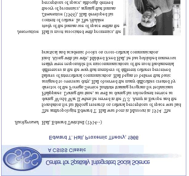
10 Strangers waiting for a train in Oklahoma try to maintain at least 18" of personal space. Edward Hall's theory of proxemics suggests that people will maintain differing degrees of personal distance depending on the social setting and their cultural backgrounds.
11

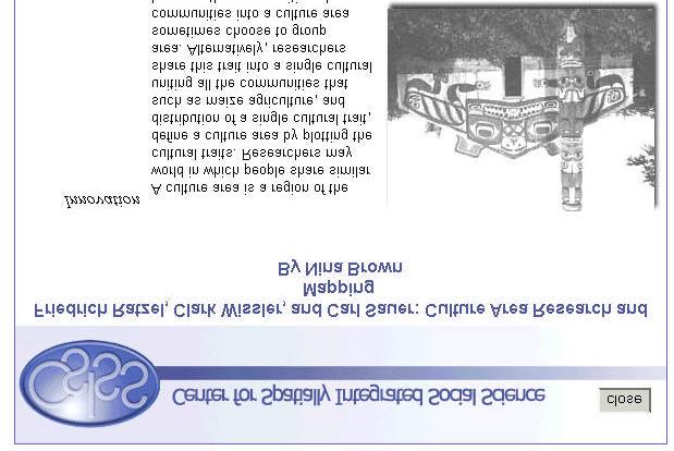
12 The map highlights similarities in food gathering techniques for seven culture areas

13 Cultural Area: Related Work and Web Links
14
15 CSISS Classics in Anthropology?? To what extent is space the 'great un-named' variable in anthropological research? Anthropology s role in documenting the environmental and cultural distinctiveness of places and regions. Spatial integration, though primarily implicit rather than explicit, is an important component of anthropological theory. Can these contributions be expressed in a more explicitly spatial way as examples of spatial thinking and spatial analysis in anthropology?

16 Bronislaw Malinowski A CSISS Classic? Noted for fieldwork and for theoretical contribution to 'functionalism' Documented the ceremonial exchange known as the Kula among the Trobriand Islanders of the South Pacific The Kula helped maintain social relations and trading networks with people across vast expanses of ocean. a long-distance balanced reciprocity to cope with vast spaces.

17 Margaret Mead a CSISS Classic? Noted for fieldwork and for theoretical contributions in gender and personality research. Are there spatial dimensions to her research that can be made more explicit? In studies of the Mundugumor (Biwat of Papua New Guinea), how is space treated in the contexts of subsistence, trade, and settlement patterns?
18
19
20
21
22
23
24 CSISS Web Search Engine Building databases of web sites Thunderstone s Texis Webinator web walking and indexing software (seeded with ~1500 terms related to spatial social science) About 36,000 websites / updated weekly User Searchable via keyword entries or access via directories
25
26
27
28
29
30

31 Database of ~ 10,000 entries Searches abstracts and keywords Retrieves bibliographic references Derived from Econ Lit, Sociological Abstracts, Social Sciences Citation Index, Humanities Citation Index, MLA International Bibliography, Anthropological Literature, Historical Abstracts, America: History and Life, and California Digital Library
32
33 CSISS Summer Workshops 2003 Accessibility in Space and Time: A GIS Approach?? July, Ohio State University (Mei-Po Kwan) Introduction to Spatial Pattern Analysis in a GIS Environment, 28 July 1 August, UCSB (Arthur Getis) Geographically Weighted Regression, 4-8 August (Stewart Fotheringham) Spatial Analysis in Population Studies?? July, Pennsylvania State University (Stephen Matthews) to apply and to learn more about the workshops. ICPSR Workshops (with Luc Anselin) Introduction to Spatial Data Analysis (UIUC) Spatial Regression Analysis (University of Michigan)
34
35 CSISS Best Practice Publications Spatially Integrated Social Science MF Goodchild and DG Janelle, eds. Oxford University Press, 2003 Advances in Spatial Econometric Modeling L Anselin, RJGM Florax, and SJ Rey, eds. Springer-Verlag, 2003


36 Center for Spatially Integrated Social Science Building resources for spatial analysis in the social sciences UCSB / Principal Investigator: M.F. Goodchild Co-PI: R.P. Appelbaum Program Director: D.G. Janelle Internet Gateway to Spatial Analysis Virtual Community for Spatial Social Science Learning Resources for Researchers Summer National Workshop Program Spatial Analytic Tools Development L. Anselin
CSISS Resources for Research and Teaching
 CSISS Resources for Research and Teaching Donald G. Janelle Center for Spatially Integrated Social Science University of California, Santa Barbara Montreal 26 July 2003 Workshop on Spatial Analysis for
The Case for Space in the Social Sciences
 The Case for Space in the Social Sciences Don Janelle Center for Spatially Integrated Social Science University of California, Santa Barbara Roundtable on Geographical Voices and Geographical Analysis
SPACE Workshop Santa Barbara, California July 2007
 SPACE Workshop Santa Barbara, California 15 20 July 2007 Modeling a Center for Spatially Integrated Social Science Critical Themes in Social Science + Tools and Concepts for Spatial Thinking + Infrastructure
SPACE Workshop NSF NCGIA CSISS UCGIS SDSU. Aldstadt, Getis, Jankowski, Rey, Weeks SDSU F. Goodchild, M. Goodchild, Janelle, Rebich UCSB
 SPACE Workshop NSF NCGIA CSISS UCGIS SDSU Aldstadt, Getis, Jankowski, Rey, Weeks SDSU F. Goodchild, M. Goodchild, Janelle, Rebich UCSB August 2-8, 2004 San Diego State University Some Examples of Spatial
Spatial Perspectives on Analysis for Curriculum Enhancement (SPACE)
") Spatial Perspectives on Analysis for Curriculum Enhancement (SPACE) NSF Proposal 0231263: NSF 02-043 CCLI National Dissemination Submitted 6 June 2002; Revised 29 April 2003 PI: Donald G. Janelle Co-PIs:
Spatial Perspectives on Analysis for Curriculum Enhancement (SPACE) NSF Proposal 0231263: NSF 02-043 CCLI National Dissemination Submitted 6 June 2002; Revised 29 April 2003 PI: Donald G. Janelle Co-PIs:
Spatial Modeling, Regional Science, Arthur Getis Emeritus, San Diego State University March 1, 2016
 Spatial Modeling, Regional Science, and UCSB Arthur Getis Emeritus, San Diego State University March 1, 2016 My Link to UCSB The 1980s at UCSB (summers and sabbatical) Problems within Geography: The Quantitative
INTEGRATING GEOSPATIAL PERSPECTIVES IN THE ANTHROPOLOGY CURRICULUM AT THE UNIVERSITY OF NEW MEXICO (UNM)
") INTEGRATING GEOSPATIAL PERSPECTIVES IN THE ANTHROPOLOGY CURRICULUM AT THE UNIVERSITY OF NEW MEXICO (UNM) VERONICA ARIAS HEATHER RICHARDS JUDITH VAN DER ELST DEPARTMENT OF ANTHROPOLOGY MARCH 2005 INTEGRATING
INTEGRATING GEOSPATIAL PERSPECTIVES IN THE ANTHROPOLOGY CURRICULUM AT THE UNIVERSITY OF NEW MEXICO (UNM) VERONICA ARIAS HEATHER RICHARDS JUDITH VAN DER ELST DEPARTMENT OF ANTHROPOLOGY MARCH 2005 INTEGRATING
The Scope and Growth of Spatial Analysis in the Social Sciences
 context. 2 We applied these search terms to six online bibliographic indexes of social science Completed as part of the CSISS literature search initiative on November 18, 2003 The Scope and Growth of Spatial
From Research Objects to Research Networks: Combining Spatial and Semantic Search
 From Research Objects to Research Networks: Combining Spatial and Semantic Search Sara Lafia 1 and Lisa Staehli 2 1 Department of Geography, UCSB, Santa Barbara, CA, USA 2 Institute of Cartography and
Spatial Analysis 1. Introduction
 Spatial Analysis 1 Introduction Geo-referenced Data (not any data) x, y coordinates (e.g., lat., long.) ------------------------------------------------------ - Table of Data: Obs. # x y Variables -------------------------------------
A spatial literacy initiative for undergraduate education at UCSB
 A spatial literacy initiative for undergraduate education at UCSB Mike Goodchild & Don Janelle Department of Geography / spatial@ucsb University of California, Santa Barbara ThinkSpatial Brown bag forum
A.P. Human Geography
 A.P. Human Geography 2012-2013 Instructor: Chris Vitt Brief Description of Course AP Human Geography is designed to provide students with a learning experience equivalent to that obtained in most college
Department of Geography, University of California Santa Barbara, USA b California NanoSystems Institute, University of California Santa Barbara, USA
 This article was downloaded by: On: 11 May 2010 Access details: Access Details: Free Access Publisher Routledge Informa Ltd Registered in England and Wales Registered Number: 1072954 Registered office:
Canadian Historical GIS Partnership Development: Taking Steps for Historical Mapping in Canada
 Canadian Historical GIS Partnership Development: Taking Steps for Historical Mapping in Canada Byron Moldofsky Manager, GIS and Cartography Office Department of Geography and Planning University of Toronto
GIS and Demography. John R. Weeks Professor of Geography and Director International Population Center
 GIS and Demography John R. Weeks Professor of Geography and Director International Population Center Introduction to Spatial Pattern Analysis in a GIS Environment Center for Spatially Integrated Social
International Development
 International Development Office: The Payson Center for International Development and Technology Transfer, 300 Hébert Hall Phone: 504-865-5240 Fax: 504-865-5241 Website: www.payson.tulane.edu/ Program
State and National Standard Correlations NGS, NCGIA, ESRI, MCHE
 GEOGRAPHIC INFORMATION SYSTEMS (GIS) COURSE DESCRIPTION SS000044 (1 st or 2 nd Sem.) GEOGRAPHIC INFORMATION SYSTEMS (11, 12) ½ Unit Prerequisite: None This course is an introduction to Geographic Information
Techniques for Science Teachers: Using GIS in Science Classrooms.
 Techniques for Science Teachers: Using GIS in Science Classrooms. After ESRI, 2008 GIS A Geographic Information System A collection of computer hardware, software, and geographic data used together for
Archaeology & Digital Humanities
 WAYNE STATE UNIVERSITY Archaeology & Digital Humanities The D.I.R.T. on Big Data STRENGTHENING THE BIG DATA & ANALYTICS ECOSYSTEM WAYNE STATE UNIVERSITY Krysta Ryzewski Associate Professor of Anthropology
Curriculum Vitae. Dr. Danqing (Dana) Xiao. Ph.D. in Department of Geography, University of California Santa Barbara.
 Xiao. Ph.D. in Department of Geography, University of California Santa Barbara.") Curriculum Vitae Dr. Danqing (Dana) Xiao Personal Information Assistant Professor Department of Environmental, Geographical, and Geological Sciences (EGGS), Bloomsburg University of Pennsylvania Research
Curriculum Vitae Dr. Danqing (Dana) Xiao Personal Information Assistant Professor Department of Environmental, Geographical, and Geological Sciences (EGGS), Bloomsburg University of Pennsylvania Research
University of Lusaka
 University of Lusaka BSPH 315 Health Mapping & GIS Topic: Background of GIS Content: 1. Aim of the course 2. What do you know about GIS? 3. Difference between geographic data and geographic information
Towards Geographic Information Observatories
 Towards Geographic Information Observatories Krzysztof Janowicz 1, Benjamin Adams 2, Grant McKenzie 1, and Tomi Kauppinen 3,4 1 University of California, Santa Barbara, USA 2 The University of Auckland,
The Link between GIS and spatial analysis. GIS, spatial econometrics and social science research
 J Geograph Syst (2000) 2:11±15 ( Springer-Verlag 2000 Part 2 The Link between GIS and spatial analysis GIS, spatial econometrics and social science research Luc Anselin Department of Agricultural and Consumer
METHODS FOR STATISTICS
 DYNAMIC CARTOGRAPHIC METHODS FOR VISUALIZATION OF HEALTH STATISTICS Radim Stampach M.Sc. Assoc. Prof. Milan Konecny Ph.D. Petr Kubicek Ph.D. Laboratory on Geoinformatics and Cartography, Department of
GIS in Weather and Society
 GIS in Weather and Society Olga Wilhelmi Institute for the Study of Society and Environment National Center for Atmospheric Research WAS*IS November 8, 2005 Boulder, Colorado Presentation Outline GIS basic
PLANNING (PLAN) Planning (PLAN) 1
 Planning (PLAN) 1") Planning (PLAN) 1 PLANNING (PLAN) PLAN 500. Economics for Public Affairs Description: An introduction to basic economic concepts and their application to public affairs and urban planning. Note: Cross-listed
Planning (PLAN) 1 PLANNING (PLAN) PLAN 500. Economics for Public Affairs Description: An introduction to basic economic concepts and their application to public affairs and urban planning. Note: Cross-listed
The Importance of Spatial Literacy
 The Importance of Spatial Literacy Dr. Michael Phoenix GIS Education Consultant Taiwan, 2009 What is Spatial Literacy? Spatial Literacy is the ability to be able to include the spatial dimension in our
Course Introduction II
 CULTURE GEOG 247 Cultural Geography Course Introduction II Prof. Anthony Grande Hunter College-CUNY AFG 2015 Culture is the essence of human geography because it influences all aspects of life on earth.
What is GIS? ESRI Canada. August 2011
 What is GIS? ESRI Canada August 2011 Geography Matters! Environmental Park Management Agriculture Public Utilities Health Care Emergency 911 Real Estate Marketing Environmental What are the effects of
Unit 1 Welcome to the World
 Unit Welcome to the World There are five fields of learning in social studies. We learn about the world and its people by studying geography, history, economics, government, and culture. A Mongolian yurt,
Cartography and Children Commission: Proposals for the next 4 years
 International Cartographic Association Cartography and Children Commission: Proposals for the next 4 years José Jesús Reyes Nuñez Eötvös Loránd University Dept. of Cartography and Geoinformatics Budapest,
Rural Louisiana. A quarterly publication of the Louisiana Tech Rural Development Center
 Rural Louisiana A quarterly publication of the Louisiana Tech Rural Development Center Volume 4, No. 1, Fall 2009 Editor: Aaron K. Lusby Director, Asst. Professor Newsletter design: Stephanie Tidwell Student
GIS Education Activities in Detroit Public Schools Preparing Students for Careers in the Geospatial Industry A Multi-Agency Collaboration
 GIS Education Activities in Detroit Public Schools Preparing Students for Careers in the Geospatial Industry A Multi-Agency Collaboration Marsha A. Lewis, Social Studies Curriculum Specialist, Detroit
Many Ways to Name a Place
 Your web browser (Safari 7) is out of date. For more security, comfort and Activityapply the best experience on this site: Update your browser Ignore Many Ways to Name a Place What are the names for the
SPATIAL SOCIAL SCIENCE FOR RESEARCH, TEACHING, APPLICATION, AND POLICY
 SPATIAL SOCIAL SCIENCE FOR RESEARCH, TEACHING, APPLICATION, AND POLICY ? Spatial Social Science Spatial Social Science recognizes the key role that spatial concepts, such as distance, location, proximity,
Spatial Data Discovery and Support in a Library Setting
 Spatial Data Discovery and Support in a Library Setting Marcel Fortin Map and Data Library University of Toronto Expert Meeting on Spatial Discovery Santa Barbara June 2015 Spatial Communities - U of Toronto
Spatial Analysis in CyberGIS
 Spatial Analysis in CyberGIS towards a spatial econometrics workbench Luc Anselin, Sergio Rey and Myunghwa Hwang GeoDa Center School of Geographical Sciences and Urban Planning Arizona State University
School of Geography and Geosciences. Head of School Degree Programmes. Programme Requirements. Modules. Geography and Geosciences 5000 Level Modules
 School of Geography and Geosciences Head of School Degree Programmes Graduate Diploma: Dr W E Stephens Health Geography Research Environmental History and Policy (see School of History) M.Res.: M.Litt.:
Exploratory Spatial Data Analysis and GeoDa
 Exploratory Spatial Data Analysis and GeoDa Luc Anselin Spatial Analysis Laboratory Dept. Agricultural and Consumer Economics University of Illinois, Urbana-Champaign http://sal.agecon.uiuc.edu Outline
Joanne N. Halls, PhD Dept. of Geography & Geology David Kirk Information Technology Services
 Joanne N. Halls, PhD Dept. of Geography & Geology David Kirk Information Technology Services Geographic Information Systems manage and analyze data to solve spatial problems. Real World Abstraction Analysis
Geospatial Services in Special Libraries: A Needs Assessment Perspective
 Purdue University Purdue e-pubs Libraries Faculty and Staff Scholarship and Research Purdue Libraries 5-17-2013 Geospatial Services in Special Libraries: A Needs Assessment Perspective Ilana R. Barnes
2018 ESRI Education Summit. San Diego. California. Sunday July 8 th 2018 Harper College, Palatine, Illinois, USA Dr. Tong Cheng (Biology), Dr.
, Dr.") 2018 ESRI Education Summit. San Diego. California. Sunday July 8 th 2018 Harper College, Palatine, Illinois, USA Dr. Tong Cheng (Biology), Dr. James Gramlich (Sociology), Mukila Maitha (Geography), Dr.
2018 ESRI Education Summit. San Diego. California. Sunday July 8 th 2018 Harper College, Palatine, Illinois, USA Dr. Tong Cheng (Biology), Dr. James Gramlich (Sociology), Mukila Maitha (Geography), Dr.
Advanced Placement Human Geography
 Advanced Placement Human Geography I. Overview of the Course The purpose of the Advanced Placement (AP) Human Geography course is to introduce students to the systematic study of patterns and processes
8/28/2011. Contents. Lecture 1: Introduction to GIS. Dr. Bo Wu Learning Outcomes. Map A Geographic Language.
 Contents Lecture 1: Introduction to GIS Dr. Bo Wu lsbowu@polyu.edu.hk Department of Land Surveying & Geo-Informatics The Hong Kong Polytechnic University 1. Learning outcomes 2. GIS definition 3. GIS examples
GeoWorlds: Integrated Digital Libraries and Geographic Information Systems
 GeoWorlds: Integrated Digital Libraries and Geographic Information Systems http://www.isi.edu/geoworlds Robert Neches In-Young Ko, Robert MacGregor, Ke-Thia Yao Distributed Scalable Systems Division USC
History and Social Science: Advanced Placement Human Geography
 History and Social Science: Advanced Placement Human Geography A.P. Human Geography Curriculum for Loudoun County Public Schools Ashburn, Virginia 2016 This curriculum document for Advanced Placement Human
Brian D. George. GIMS Specialist Ohio Coastal Atlas Project Coordinator and Cartographer. Impacts and Outcomes of Mature Coastal Web Atlases
 Ohio Coastal Atlas Project Brian D. George GIMS Specialist Ohio Coastal Atlas Project Coordinator and Cartographer Ohio Department of Natural Resources Office of Coastal Management Sandusky, OH Impacts
Lesson 8. Natural Disasters
 Lesson 8 Natural Disasters 1 Reading is NOT a spectator sport! 2 Reading requires active participation! 3 PREDICT Try to figure out what information will come next and how the selection might end. 4 Natural
Cyberinfrastructure and CyberGIS: Recent Advances and Key Themes
 Cyberinfrastructure and CyberGIS: Recent Advances and Key Themes Shaowen Wang CyberInfrastructure and Geospatial Information Laboratory (CIGI) Department of Geography Department of Computer Science National
Fundamental Spatial Concepts. Michael F. Goodchild University of California Santa Barbara
 Fundamental Spatial Concepts Michael F. Goodchild University of California Santa Barbara A spatial turn in science Adding space to theory the New Economic Geography space impeding flows of information,
geographic patterns and processes are captured and represented using computer technologies
 Proposed Certificate in Geographic Information Science Department of Geographical and Sustainability Sciences Submitted: November 9, 2016 Geographic information systems (GIS) capture the complex spatial
BACHELOR OF GEOINFORMATION TECHNOLOGY (NQF Level 7) Programme Aims/Purpose:
 Programme Aims/Purpose:") BACHELOR OF GEOINFORMATION TECHNOLOGY ( Level 7) Programme Aims/Purpose: The Bachelor of Geoinformation Technology aims to provide a skilful and competent labour force for the growing Systems (GIS) industry
BACHELOR OF GEOINFORMATION TECHNOLOGY ( Level 7) Programme Aims/Purpose: The Bachelor of Geoinformation Technology aims to provide a skilful and competent labour force for the growing Systems (GIS) industry
GIScience: Current Technology. Michael F. Goodchild University of California Santa Barbara
 GIScience: Current Technology Michael F. Goodchild University of California Santa Barbara What is a GIS? A class of software designed to handle geographic information and perform virtually any conceivable
GRADUATE CERTIFICATE PROGRAM
 GRADUATE CERTIFICATE PROGRAM GEOGRAPHIC INFORMATION SCIENCES Department of Geography University of North Carolina Chapel Hill Conghe Song, Director csong @email.unc.edu 919-843-4764 (voice) 919-962-1537
Introducing the. a partnership of
 Introducing the a partnership of Background Need for online atlas identified by managers and researchers to make coastal data available Shoreline data Ocean and coastal resources Sea-level rise potential
STUDY GUIDE. Exploring Geography. Chapter 1, Section 1. Terms to Know DRAWING FROM EXPERIENCE ORGANIZING YOUR THOUGHTS
 For use with textbook pages 19 22. Exploring Geography Terms to Know location A specific place on the earth (page 20) absolute location The exact spot at which a place is found on the globe (page 20) hemisphere
The History Behind Census Geography
 The History Behind Census Geography Michael Ratcliffe Geography Division US Census Bureau Kentucky State Data Center Affiliate Meeting August 5, 2016 Today s Presentation A brief look at the history behind
GIS = Geographic Information Systems;
 What is GIS GIS = Geographic Information Systems; What Information are we talking about? Information about anything that has a place (e.g. locations of features, address of people) on Earth s surface,
AAG Partnerships for. Sustainable Development in Africa: Geospatial Science & Technology for. Partnerships and Applications
 AAG Partnerships for Sustainable Development in Africa Geospatial Science & Technology for Sustainable Development in Africa: Partnerships and Applications Harvard University John F. Kennedy School of
GIS Geographical Information Systems. GIS Management
 GIS Geographical Information Systems GIS Management Difficulties on establishing a GIS Funding GIS Determining Project Standards Data Gathering Map Development Recruiting GIS Professionals Educating Staff
GIS at UCAR. The evolution of NCAR s GIS Initiative. Olga Wilhelmi ESIG-NCAR Unidata Workshop 24 June, 2003
 GIS at UCAR The evolution of NCAR s GIS Initiative Olga Wilhelmi ESIG-NCAR Unidata Workshop 24 June, 2003 Why GIS? z z z z More questions about various climatological, meteorological, hydrological and
Seymour Centre 2017 Education Program 2071 CURRICULUM LINKS
 Suitable for: Stage 5 Stage 6 HSC Subject Links: Seymour Centre 2017 Education Program 2071 CURRICULUM LINKS Science Stage Content Objective Outcomes Stage 5 Earth and Space ES3: People use scientific
Institutional Opportunities and Constraints. Michael F. Goodchild
 Institutional Opportunities and Constraints Michael F. Goodchild A conceptual framework Nomothetic science knowledge that is true everywhere in space and time Idiographic science the study of the unique
Application for Horizon Research and Innovation Framework Programme. ANTHUSIA Anthropology of Human Security in Africa (48 months)
") Application for Horizon 2020 - Research and Innovation Framework Programme ANTHUSIA Anthropology of Human Security in Africa (48 months) 2 Presentation of IARA (Institute for Anthropological Research in
Application for Horizon 2020 - Research and Innovation Framework Programme ANTHUSIA Anthropology of Human Security in Africa (48 months) 2 Presentation of IARA (Institute for Anthropological Research in
World Geography TEKS 2nd Nine Weeks. Unit of Study Regional Studies; U.S. and Canada Regional Studies; Latin America; and Europe
 World Geography TEKS 2nd Nine Weeks Unit of Study Regional Studies; U.S. and Canada Regional Studies; Latin America; and Europe 1) History. The student understands how geography and processes of spatial
Global Perspectives Goals & Objectives: (include numbers) Learning Essentials Materials/ Resources
 Learning Essentials Materials/ Resources") August/ September Early Civilizations Goal 1.6: Explain the rise of human civilization. 6-9.WHC.1.6.1 Describe types of evidence used by anthropologists, archaeologists, and other scholars to reconstruct
August/ September Early Civilizations Goal 1.6: Explain the rise of human civilization. 6-9.WHC.1.6.1 Describe types of evidence used by anthropologists, archaeologists, and other scholars to reconstruct
CSISS Tools and Spatial Analysis Software
 CSISS Tools and Spatial Analysis Software June 5, 2006 Stephen A. Matthews Associate Professor of Sociology & Anthropology, Geography and Demography Director of the Geographic Information Analysis Core
Esri and GIS Education
 Esri and GIS Education Organizations Esri Users 1,200 National Government Agencies 11,500 States & Regional Agencies 30,800 Cities & Local Governments 32,000 Businesses 8,500 Utilities 12,600 NGOs 11,000
Spatially Enabled Society
 International Seminar on Land Administration Trends and Issues in Asia and the Pacific Region Spatially Enabled Society Abbas Rajabifard Vice Chair PCGIAP-WG3 Vice-President (President Elect), GSDI Association
Geography at Oxford Dr Lorraine Wild
 Open Day 2018 Geography at Oxford Geography at Oxford Dr Lorraine Wild Why is Oxford special? Why is Oxford special? The School of Geography and the Environment has been ranked 1 st in the 2018 QS World
Grade 6 Social Studies
 Grade 6 Social Studies Social Studies Grade(s) 6th Course Overview This course focuses on the five Wisconsin Model Academic standards for Social Studies: Geography, History, Political Science and Citizenship,
Health and Medical Geography (GEOG 222)
") Spring 2019 Class meets: Tuesdays and Thursdays 12:30-1:45pm Carolina Hall Room 220 Instructor: Michael Emch Email: emch@unc.edu Course Objectives Health and Medical Geography (GEOG 222) This course is
Spring 2019 Class meets: Tuesdays and Thursdays 12:30-1:45pm Carolina Hall Room 220 Instructor: Michael Emch Email: emch@unc.edu Course Objectives Health and Medical Geography (GEOG 222) This course is
GEOGRAPHY (GE) Courses of Instruction
 Courses of Instruction") GEOGRAPHY (GE) GE 102. (3) World Regional Geography. The geographic method of inquiry is used to examine, describe, explain, and analyze the human and physical environments of the major regions of the
GEOGRAPHY (GE) GE 102. (3) World Regional Geography. The geographic method of inquiry is used to examine, describe, explain, and analyze the human and physical environments of the major regions of the
The Architecture of the Georgia Basin Digital Library: Using geoscientific knowledge in sustainable development
 GEOLOGIJA 46/2, 343 348, Ljubljana 2003 The Architecture of the Georgia Basin Digital Library: Using geoscientific knowledge in sustainable development B. BRODARIC 1, M. JOURNEAY 2, S. TALWAR 2,3, R. HARRAP
Spatial Tools for Econometric and Exploratory Analysis
 Spatial Tools for Econometric and Exploratory Analysis Michael F. Goodchild University of California, Santa Barbara Luc Anselin University of Illinois at Urbana-Champaign http://csiss.org Outline A Quick
An Internet-Based Integrated Resource Management System (IRMS)
") An Internet-Based Integrated Resource Management System (IRMS) Third Quarter Report, Year II 4/1/2000 6/30/2000 Prepared for Missouri Department of Natural Resources Missouri Department of Conservation
An Internet-Based Integrated Resource Management System (IRMS) Third Quarter Report, Year II 4/1/2000 6/30/2000 Prepared for Missouri Department of Natural Resources Missouri Department of Conservation
World Geography Review Syllabus
 Purpose Class: World Geography Review Syllabus This course is designed to help students review and remediate their understanding major themes, concepts, and facts connected to the study World Geography.
LEHMAN COLLEGE CITY UNIVERSITY OF NEW YORK DEPARTMENT OF ENVIRONMENTAL, GEOGRAPHIC, AND GEOLOGICAL SCIENCES CURRICULAR CHANGE
 LEHMAN COLLEGE CITY UNIVERSITY OF NEW YORK DEPARTMENT OF ENVIRONMENTAL, GEOGRAPHIC, AND GEOLOGICAL SCIENCES CURRICULAR CHANGE Hegis Code: 2206.00 Program Code: 452/2682 1. Type of Change: New Course 2.
APAN24. Xi an. Digital Silk Road. National Institute of Informatics
 APAN24 Xi an an, e-culture Digital Silk Road K. Ono, A.Kitamoto, M.Onishi, Y.Tanaka National Institute of Informatics 1 Digital Silk Road Project The Digital Silk Road Project extends the UNESCO s s 10-year
GEOGRAPHY (GEOGRPHY) Geography (GEOGRPHY) 1
 Geography (GEOGRPHY) 1") Geography (GEOGRPHY) 1 GEOGRAPHY (GEOGRPHY) GEOGRPHY 1040 Planet Earth 4 Credits The features of the natural environment (lithosphere, atmosphere and hydrosphere); their character, distribution, origin
Geography (GEOGRPHY) 1 GEOGRAPHY (GEOGRPHY) GEOGRPHY 1040 Planet Earth 4 Credits The features of the natural environment (lithosphere, atmosphere and hydrosphere); their character, distribution, origin
Finding Common Ground Through GIS
 Finding Common Ground Through GIS Matthew Stone, MPH Special Unit for Technical Assistance Chronic Disease and Injury Control California Department of Public Health ESRI Health GIS Conference Scottsdale,
SRJC Applied Technology 54A Introduction to GIS
 SRJC Applied Technology 54A Introduction to GIS Overview Lecture of Geographic Information Systems Fall 2004 Santa Rosa Junior College Presented By: Tim Pudoff, GIS Coordinator, County of Sonoma, Information
A Preliminary Model of Community-based Integrated Information System for Urban Spatial Development
 A Preliminary Model of Community-based Integrated Information System for Urban Spatial Development Bauni HAMID 1, Devin DEFRIZA 2 1 2 CAITAD (Center of Applied Information Technology in Planning and Design),
1. Pass GE1101E Geographical Journeys: Exploring World Environments. This will be counted towards the Faculty Core or UE requirements.
 H Geography At the Department of Geography, students are encouraged to develop a deeper and more critical understanding of both physical and human environments. Students will acquire knowledge, skills
Hayward, P. (2007). Mexican-American assimilation in U.S. metropolitan areas. The Pennsylvania Geographer, 45(1), 3-15.
. Mexican-American assimilation in U.S. metropolitan areas. The Pennsylvania Geographer, 45(1), 3-15.") PETER HAYWARD Assistant Professor of Geography and GIS Faculty Fellow SUNY College at Oneonta 323 Milne Library Oneonta, NY 13820 Phone: 607-436-3398 Email: haywarpm@oneonta.edu Web: http://employees.oneonta.edu/haywarpm
PETER HAYWARD Assistant Professor of Geography and GIS Faculty Fellow SUNY College at Oneonta 323 Milne Library Oneonta, NY 13820 Phone: 607-436-3398 Email: haywarpm@oneonta.edu Web: http://employees.oneonta.edu/haywarpm
LEHMAN COLLEGE OF THE CITY UNIVERSITY OF NEW YORK. 1. Type of Change: Change in Degree Requirements
 Alpha Number: Hegis Code 1214 Program Code: 30600 1. Type of Change: Change in Degree Requirements 2. From: [The curriculum consists of 45 graduate credits and includes core courses, an area of specialization,
Curriculum map GEOGRAPHY
 Curriculum map Learning outcomes (LOs): Having completed a major in Geography, a student will be able to: 1. Demonstrate an understanding of the major biophysical and social patterns in the world, and
Environmental Studies Seminar
 Graduation Requirements In addition to the requirements listed below, students must satisfy: 1. the University regulations (see the Academic Regulations of the University section of this Calendar), 2.
Faatasi Malologa (PGSC Chair) Director Department of Lands & Survey, Tuvalu
 Director Department of Lands & Survey, Tuvalu") Seventh Session of the United Nations Committee of Experts on Global Geospatial Information Management (UN-GGIM) - 31 July -4 August 2017 Faatasi Malologa (PGSC Chair) Director Department of Lands & Survey,
Seventh Session of the United Nations Committee of Experts on Global Geospatial Information Management (UN-GGIM) - 31 July -4 August 2017 Faatasi Malologa (PGSC Chair) Director Department of Lands & Survey,
Grand Challenges in GIScience: UCGIS experiences
 Grand Challenges in GIScience: UCGIS experiences 2006-2010 Tim Nyerges University of Washington University Consortium of Geographic Information Science (UCGIS) AAG Annual Meeting April 17, 2010 Outline
Dublin City Schools Social Studies Graded Course of Study Grade 5 K-12 Social Studies Vision
 K-12 Social Studies Vision The Dublin City Schools K-12 Social Studies Education will provide many learning opportunities that will help students to: develop thinking as educated citizens who seek to understand
ECONOMIC AND SOCIAL COUNCIL 13 July 2007
 UNITED NATIONS E/CONF.98/CRP.34 ECONOMIC AND SOCIAL COUNCIL 13 July 2007 Ninth United Nations Conference on the Standardization of Geographical Names New York, 21-30 August 2007 Item 17(b) of the provisional
Information Needs & Information Seeking in Internet Era: A Case Study of Geographers in Maharashtra
 International Journal of Research in Library Science ISSN: 2455-104X Indexed in: IIJIF, ijindex, SJIF,ISI Volume 2,Issue 1 (January-June) 2016,99-108 Received: 7 May 2016 ; Accepted: 12 May 2016 ; Published:
Government GIS and its Application for Decision Support
 Government GIS and its Application for Decision Support Zhang Qingpu (Chinese Academy of Surveying and Mapping, Email: zhangqp@casm.ac.cn) Abstract: Application of GIS in government agencies is called
CENSUS MAPPING WITH GIS IN NAMIBIA. BY Mrs. Ottilie Mwazi Central Bureau of Statistics Tel: October 2007
 CENSUS MAPPING WITH GIS IN NAMIBIA BY Mrs. Ottilie Mwazi Central Bureau of Statistics E-mail: omwazi@npc.gov.na Tel: + 264 61 283 4060 October 2007 Content of Presentation HISTORICAL BACKGROUND OF CENSUS
Map Collections and the Internet: Some Ideas about Various Online Map Services, Based on the ETH Map Collection in Zürich
 LIBER QUARTERLY, ISSN 1435-5205 LIBER 2000. All rights reserved K.G. Saur, Munich. Printed in Germany Map Collections and the Internet: Some Ideas about Various Online Map Services, Based on the ETH Map
Unit of Study: Physical Geography & Settlement Patterns; Culture & Civilizations; and The Spread of Ideas
 6 th Grade Social Studies 1 st Nine Weeks TEKS Unit of Study: Physical Geography & Settlement Patterns; Culture & Civilizations; and The Spread of Ideas 6.1) History. The student understands that historical
Chapter 5. GIS The Global Information System
 Chapter 5 GIS The Global Information System What is GIS? We have just discussed GPS a simple three letter acronym for a fairly sophisticated technique to locate a persons or objects position on the Earth
Core Courses for Students Who Enrolled Prior to Fall 2018
 Biostatistics and Applied Data Analysis Students must take one of the following two sequences: Sequence 1 Biostatistics and Data Analysis I (PHP 2507) This course, the first in a year long, two-course
Sample assessment task. Task details. Content description. Year level 7
 Sample assessment task Year level 7 Learning area Subject Title of task Task details Description of task Type of assessment Purpose of assessment Assessment strategy Evidence to be collected Suggested