Spatial Tools for Econometric and Exploratory Analysis
|
|
|
- Elinor Kennedy
- 6 years ago
- Views:
Transcription
1 Spatial Tools for Econometric and Exploratory Analysis Michael F. Goodchild University of California, Santa Barbara Luc Anselin University of Illinois at Urbana-Champaign
2 Outline A Quick Tour of a GIS Spatial Data Analysis CSISS Tools
3 Spatial Data Analysis
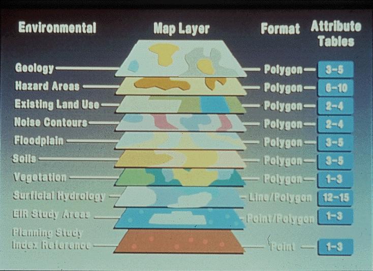
4 Principles: 1. Integration Linking data through common location the layer cake Linking processes across disciplines spatially explicit processes e.g. economic and social processes interact at common locations
5
6 2. Spatial analysis Social data collected in crosssection longitudinal data are difficult to construct Cross-sectional perspectives are rich in context can never confirm process though they can perhaps falsify useful source of hypotheses, insights
7
8 3. Spatially explicit theory Theory that is not invariant under relocation Spatial concepts (location, distance, adjacency) appear explicitly Can spatial concepts ever explain, or are they always surrogates for something else?
9 4. Place-based analysis Nomothetic - search for general principles Idiographic - description of unique properties of places An old debate in Geography
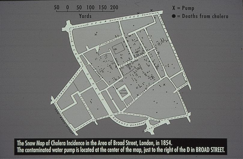
10 The Earth's surface Uncontrolled variance There is no average place Results depend explicitly on bounds Places as samples Consider the model: y = a + bx
11
12 Tract Pop Location Shape x,y x,y x,y x,y x,y x,y x,y x,y
13
14 I ij = EiAjf ( dij) / ΣkAkf ( dik) E i d ij A j
15
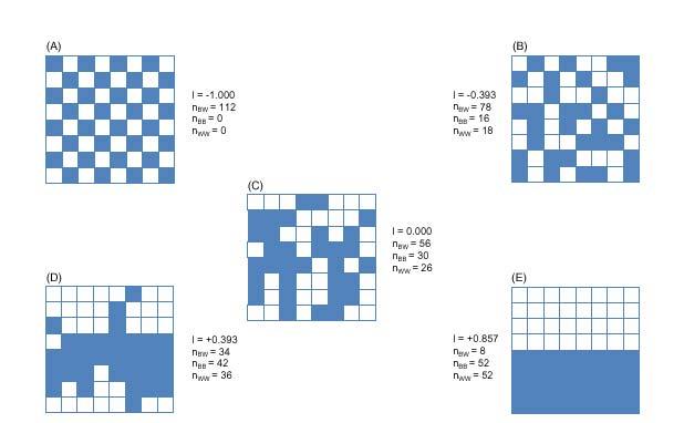
16 Types of Spatial Data Analysis Exploratory Spatial Data Analysis exploring the structure of spatial data determining the nature of spatial dependencies spatial data as context Confirmatory Spatial Data Analysis testing data against spatial models spatial econometrics econometric models that incorporate spatial effects
17 Four Elements of Spatial Econometrics Specifying the Structure of Spatial Dependence which locations/actors interact Testing for the Presence of Spatial Dependence what type of dependence what alternative Estimating Models with Spatial Dependence spatial lag, spatial error, higher order Spatial Prediction interpolation, missing values

18 Abstraction of geographic space Cartograms Invariance under rotation, displacement, reflection
19 Space as a matrix W where w ij is some measure of interaction adjacency decreasing function of distance invariant under rotation, displacement, reflection readily obtained from GIS a measure of spatial vs social interaction
20 Specification = Spatial Weights Spatially Lagged Variables Wy, Wε, WX Data Structure W not as N by N matrix sparse structure counties 5/6 neighbors Computation distance based: easy uses point coordinates generalized distance contiguity: requires GIS interface uses boundary file or tessellation
21 Software Classification Mainstream Statistics Packages SAS, SPSS, Systat Mainstream Econometric Packages Stata, TSP, Rats, Limdep, E-Views, Shazam Toolboxes Matlab, S-Plus, Bugs/WinBugs Open Source Toolboxes R, XLispstat Self-Contained Specialized SpaceStat
22 Spatial Regression Functionality Rare in Commercial Software spatial functionality tends to be geostatistics, point pattern analysis variogram, kriging e.g., SAS, Systat Specialized Scripts/Macros routines with specific functionality constrained by data format, size, speed Comprehensive SpaceStat, S+Spatialstats, Spdep (R), LeSage-Pace (Matlab), Pisati (Stata Ado)
23 Review (not comprehensive) SpaceStat linear spatial regression weights construction, diagnostics, ML, IV/GM outdated architecture and interface S+Spatialstats (Splus) linear spatial regression weights construction (ArcView bridge), ML no diagnostics Spdep (Bivand) R package, open source linear spatial regression weights construction (from boundary file), diagnostics ML estimation only other R packages: Venables-Ripley, GWR, etc.
24 Review (continued) Spatial Toolbox (LeSage, Pace) Matlab and Fortran routines linear spatial regression some weights construction (Thiessen), ML estimation (sparse weights), Bayesian estimation (Gibbs sampler) spatial probit/tobit: Gibbs sampler Stata (Pisati, Conley) Spatreg diagnostics, ML estimation, no weights from polygons GMM Conley estimator GeoBugs MCMC for conditional spatial model
25 Miscellaneous SAS spatial regression estimation (Griffith) SPSS spatial autocorrelation (Tiefelsdorf) Xlispstat Ord ML estimation using eigenvalues TSP ML estimation spatial error, spatial lag (based on Upton and Fingleton) RATS Driscoll-Kraaij estimator
26 Issues Performance Problems generic optimization routines inefficient matrix data structure slow loops Little/No Diagnostics focus tends to be on estimation No Interoperability No Standards
27 CSISS Tools
28 CSISS Tools Project Mission Goals: facilitate dissemination of spatial analysis software tools to social scientists develop a library/libraries of spatial data analysis modules develop prototypes implementing state of the art methods initiate and nurture a community of open source developers
29
30
31 GeoDa ESDA with Dynamically Linked Windows freestanding reads ESRI shape files points and polygons MapObjects LT2 technology free Replaces ArcView Extensions SpaceStat Extension and DynESDA extension now obsolete Download
32 Supporting Materials
33 Requirements and Challenges Interoperable need for standards data structures, model formulation XML adhere to/contribute to OGC Open open source promotes quality control standards allow a modular approach Fast need for efficient (new) algorithms large data set latent variable models space-time models
Exploratory Spatial Data Analysis and GeoDa
 Exploratory Spatial Data Analysis and GeoDa Luc Anselin Spatial Analysis Laboratory Dept. Agricultural and Consumer Economics University of Illinois, Urbana-Champaign http://sal.agecon.uiuc.edu Outline
GIS and Spatial Statistics: One World View or Two? Michael F. Goodchild University of California Santa Barbara
 GIS and Spatial Statistics: One World View or Two? Michael F. Goodchild University of California Santa Barbara Location as attribute The data table Census summary table What value is location as an explanatory
Luc Anselin Spatial Analysis Laboratory Dept. Agricultural and Consumer Economics University of Illinois, Urbana-Champaign
 GIS and Spatial Analysis Luc Anselin Spatial Analysis Laboratory Dept. Agricultural and Consumer Economics University of Illinois, Urbana-Champaign http://sal.agecon.uiuc.edu Outline GIS and Spatial Analysis
Mapping and Analysis for Spatial Social Science
 Mapping and Analysis for Spatial Social Science Luc Anselin Spatial Analysis Laboratory Dept. Agricultural and Consumer Economics University of Illinois, Urbana-Champaign http://sal.agecon.uiuc.edu Outline
Spatial Autocorrelation (2) Spatial Weights
 Spatial Weights") Spatial Autocorrelation (2) Spatial Weights Luc Anselin Spatial Analysis Laboratory Dept. Agricultural and Consumer Economics University of Illinois, Urbana-Champaign http://sal.agecon.uiuc.edu Outline
Spatial Autocorrelation (2) Spatial Weights Luc Anselin Spatial Analysis Laboratory Dept. Agricultural and Consumer Economics University of Illinois, Urbana-Champaign http://sal.agecon.uiuc.edu Outline
Outline ESDA. Exploratory Spatial Data Analysis ESDA. Luc Anselin
 Exploratory Spatial Data Analysis ESDA Luc Anselin University of Illinois, Urbana-Champaign http://www.spacestat.com Outline ESDA Exploring Spatial Patterns Global Spatial Autocorrelation Local Spatial
CSISS Tools and Spatial Analysis Software
 CSISS Tools and Spatial Analysis Software June 5, 2006 Stephen A. Matthews Associate Professor of Sociology & Anthropology, Geography and Demography Director of the Geographic Information Analysis Core
Spatial Analysis 1. Introduction
 Spatial Analysis 1 Introduction Geo-referenced Data (not any data) x, y coordinates (e.g., lat., long.) ------------------------------------------------------ - Table of Data: Obs. # x y Variables -------------------------------------
Exploratory Spatial Data Analysis (And Navigating GeoDa)
") Exploratory Spatial Data Analysis (And Navigating GeoDa) June 9, 2006 Stephen A. Matthews Associate Professor of Sociology & Anthropology, Geography and Demography Director of the Geographic Information
Exploratory Spatial Data Analysis (And Navigating GeoDa) June 9, 2006 Stephen A. Matthews Associate Professor of Sociology & Anthropology, Geography and Demography Director of the Geographic Information
Spatial Modeling, Regional Science, Arthur Getis Emeritus, San Diego State University March 1, 2016
 Spatial Modeling, Regional Science, and UCSB Arthur Getis Emeritus, San Diego State University March 1, 2016 My Link to UCSB The 1980s at UCSB (summers and sabbatical) Problems within Geography: The Quantitative
Introduction to Spatial Statistics and Modeling for Regional Analysis
 Introduction to Spatial Statistics and Modeling for Regional Analysis Dr. Xinyue Ye, Assistant Professor Center for Regional Development (Department of Commerce EDA University Center) & School of Earth,
Comparing estimation methods. econometrics
 for spatial econometrics Recent Advances in Spatial Econometrics (in honor of James LeSage), ERSA 2012 Roger Bivand Gianfranco Piras NHH Norwegian School of Economics Regional Research Institute at West
Spatial Analysis in CyberGIS
 Spatial Analysis in CyberGIS towards a spatial econometrics workbench Luc Anselin, Sergio Rey and Myunghwa Hwang GeoDa Center School of Geographical Sciences and Urban Planning Arizona State University
SPACE Workshop NSF NCGIA CSISS UCGIS SDSU. Aldstadt, Getis, Jankowski, Rey, Weeks SDSU F. Goodchild, M. Goodchild, Janelle, Rebich UCSB
 SPACE Workshop NSF NCGIA CSISS UCGIS SDSU Aldstadt, Getis, Jankowski, Rey, Weeks SDSU F. Goodchild, M. Goodchild, Janelle, Rebich UCSB August 2-8, 2004 San Diego State University Some Examples of Spatial
Development of Integrated Spatial Analysis System Using Open Sources. Hisaji Ono. Yuji Murayama
 Development of Integrated Spatial Analysis System Using Open Sources Hisaji Ono PASCO Corporation 1-1-2, Higashiyama, Meguro-ku, TOKYO, JAPAN; Telephone: +81 (03)3421 5846 FAX: +81 (03)3421 5846 Email:
Kriging Luc Anselin, All Rights Reserved
 Kriging Luc Anselin Spatial Analysis Laboratory Dept. Agricultural and Consumer Economics University of Illinois, Urbana-Champaign http://sal.agecon.uiuc.edu Outline Principles Kriging Models Spatial Interpolation
Spatial Regression. 1. Introduction and Review. Luc Anselin. Copyright 2017 by Luc Anselin, All Rights Reserved
 Spatial Regression 1. Introduction and Review Luc Anselin http://spatial.uchicago.edu matrix algebra basics spatial econometrics - definitions pitfalls of spatial analysis spatial autocorrelation spatial
Spatial Effects and Externalities
 Spatial Effects and Externalities Philip A. Viton November 5, Philip A. Viton CRP 66 Spatial () Externalities November 5, / 5 Introduction If you do certain things to your property for example, paint your
The Case for Space in the Social Sciences
 The Case for Space in the Social Sciences Don Janelle Center for Spatially Integrated Social Science University of California, Santa Barbara Roundtable on Geographical Voices and Geographical Analysis
Visualize and interactively design weight matrices
 Visualize and interactively design weight matrices Angelos Mimis *1 1 Department of Economic and Regional Development, Panteion University of Athens, Greece Tel.: +30 6936670414 October 29, 2014 Summary
EXPLORATORY SPATIAL DATA ANALYSIS OF BUILDING ENERGY IN URBAN ENVIRONMENTS. Food Machinery and Equipment, Tianjin , China
 EXPLORATORY SPATIAL DATA ANALYSIS OF BUILDING ENERGY IN URBAN ENVIRONMENTS Wei Tian 1,2, Lai Wei 1,2, Pieter de Wilde 3, Song Yang 1,2, QingXin Meng 1 1 College of Mechanical Engineering, Tianjin University
Working Paper
 Working Paper 2008-12 Dynamic Manipulation of Spatial Weights Using Web Services Sergio J. Rey, Luc Anselin, and Myunghwa Hwang Dynamic Manipulation of Spatial Weights Using Web Services Sergio J. Rey
Creating and Managing a W Matrix
 Creating and Managing a W Matrix Carlos Hurtado Department of Economics University of Illinois at Urbana-Champaign hrtdmrt2@illinois.edu Junel 22th, 2016 C. Hurtado (UIUC - Economics) Spatial Econometrics
Spatial Analysis II. Spatial data analysis Spatial analysis and inference
 Spatial Analysis II Spatial data analysis Spatial analysis and inference Roadmap Spatial Analysis I Outline: What is spatial analysis? Spatial Joins Step 1: Analysis of attributes Step 2: Preparing for
Exploratory Spatial Data Analysis (ESDA)
") Exploratory Spatial Data Analysis (ESDA) VANGHR s method of ESDA follows a typical geospatial framework of selecting variables, exploring spatial patterns, and regression analysis. The primary software
Exploratory Spatial Data Analysis (ESDA) VANGHR s method of ESDA follows a typical geospatial framework of selecting variables, exploring spatial patterns, and regression analysis. The primary software
Geometric Algorithms in GIS
 Geometric Algorithms in GIS GIS Software Dr. M. Gavrilova GIS System What is a GIS system? A system containing spatially referenced data that can be analyzed and converted to new information for a specific
Exploratory Spatial Data Analysis Using GeoDA: : An Introduction
 Exploratory Spatial Data Analysis Using GeoDA: : An Introduction Prepared by Professor Ravi K. Sharma, University of Pittsburgh Modified for NBDPN 2007 Conference Presentation by Professor Russell S. Kirby,
I don t have much to say here: data are often sampled this way but we more typically model them in continuous space, or on a graph
 Spatial analysis Huge topic! Key references Diggle (point patterns); Cressie (everything); Diggle and Ribeiro (geostatistics); Dormann et al (GLMMs for species presence/abundance); Haining; (Pinheiro and
Lecture 3: Exploratory Spatial Data Analysis (ESDA) Prof. Eduardo A. Haddad
 Prof. Eduardo A. Haddad") Lecture 3: Exploratory Spatial Data Analysis (ESDA) Prof. Eduardo A. Haddad Key message Spatial dependence First Law of Geography (Waldo Tobler): Everything is related to everything else, but near things
Lecture 3: Exploratory Spatial Data Analysis (ESDA) Prof. Eduardo A. Haddad Key message Spatial dependence First Law of Geography (Waldo Tobler): Everything is related to everything else, but near things
Spatial Data Mining. Regression and Classification Techniques
 Spatial Data Mining Regression and Classification Techniques 1 Spatial Regression and Classisfication Discrete class labels (left) vs. continues quantities (right) measured at locations (2D for geographic
Spatial Regression Modeling
 Spatial Regression Modeling Paul Voss & Katherine Curtis The Center for Spatially Integrated Social Science Santa Barbara, CA July 12-17, 2009 Day 1 Objective Provide a solid introduction and overview
VISUALIZING MULTIVARIATE SPATIAL CORRELATION WITH DYNAMICALLY LINKED WINDOWS
 The Regional Economics Applications Laboratory (REAL) is a cooperative venture between the University of Illinois and the Federal Reserve Bank of Chicago focusing on the development and use of analytical
Contents. Preface. Introduction 1 Manfred M. Fischer and Arthur Getis. GI Software Tools
 Contents Preface v Introduction 1 Manfred M. Fischer and Arthur Getis PART A GI Software Tools A.1 Spatial Statistics in ArcGIS Lauren M. Scott and Mark V. Janikas A.1.1 Introduction 27 A.1.2 Measuring
Spatial Thinking and Modeling of Network-Based Problems
 Spatial Thinking and Modeling of Network-Based Problems Presentation at the SPACE Workshop Columbus, Ohio, July 1, 25 Shih-Lung Shaw Professor Department of Geography University of Tennessee Knoxville,
VISUALIZING SPATIAL AUTOCORRELATION WITH DYNAMICALLY LINKED WINDOWS by Luc Anselin, Ibnu Syabri, Oleg Smirnov and Yanqui Ren
 The Regional Economics Applications Laboratory (REAL) is a cooperative venture between the University of Illinois and the Federal Reserve Bank of Chicago focusing on the development and use of analytical
Lecture 5 Geostatistics
 Lecture 5 Geostatistics Lecture Outline Spatial Estimation Spatial Interpolation Spatial Prediction Sampling Spatial Interpolation Methods Spatial Prediction Methods Interpolating Raster Surfaces with
ENGRG Introduction to GIS
 ENGRG 59910 Introduction to GIS Michael Piasecki October 13, 2017 Lecture 06: Spatial Analysis Outline Today Concepts What is spatial interpolation Why is necessary Sample of interpolation (size and pattern)
Spatial analysis. 0 move the objects and the results change
 0 Outline: Roadmap 0 What is spatial analysis? 0 Transformations 0 Introduction to spatial interpolation 0 Classification of spatial interpolation methods 0 Interpolation methods 0 Areal interpolation
Lecture 3: Exploratory Spatial Data Analysis (ESDA) Prof. Eduardo A. Haddad
 Prof. Eduardo A. Haddad") Lecture 3: Exploratory Spatial Data Analysis (ESDA) Prof. Eduardo A. Haddad Key message Spatial dependence First Law of Geography (Waldo Tobler): Everything is related to everything else, but near things
Lecture 3: Exploratory Spatial Data Analysis (ESDA) Prof. Eduardo A. Haddad Key message Spatial dependence First Law of Geography (Waldo Tobler): Everything is related to everything else, but near things
Concepts and Applications of Kriging. Eric Krause
 Concepts and Applications of Kriging Eric Krause Sessions of note Tuesday ArcGIS Geostatistical Analyst - An Introduction 8:30-9:45 Room 14 A Concepts and Applications of Kriging 10:15-11:30 Room 15 A
Departamento de Economía Universidad de Chile
 Departamento de Economía Universidad de Chile GRADUATE COURSE SPATIAL ECONOMETRICS November 14, 16, 17, 20 and 21, 2017 Prof. Henk Folmer University of Groningen Objectives The main objective of the course
GIST 4302/5302: Spatial Analysis and Modeling
 GIST 4302/5302: Spatial Analysis and Modeling Spring 2014 Lectures: Tuesdays & Thursdays 2:00pm-2:50pm, Holden Hall 00038 Lab sessions: Tuesdays or Thursdays 3:00pm-4:50pm or Wednesday 1:00pm-2:50pm, Holden
Spatial Analysis and Modeling (GIST 4302/5302) Guofeng Cao Department of Geosciences Texas Tech University
 Guofeng Cao Department of Geosciences Texas Tech University") Spatial Analysis and Modeling (GIST 4302/5302) Guofeng Cao Department of Geosciences Texas Tech University TTU Graduate Certificate Geographic Information Science and Technology (GIST) 3 Core Courses and
Spatial Analysis and Modeling (GIST 4302/5302) Guofeng Cao Department of Geosciences Texas Tech University TTU Graduate Certificate Geographic Information Science and Technology (GIST) 3 Core Courses and
Measures of Spatial Dependence
 Measures of Spatial Dependence Carlos Hurtado Department of Economics University of Illinois at Urbana-Champaign hrtdmrt2@illinois.edu Junel 30th, 2016 C. Hurtado (UIUC - Economics) Spatial Econometrics
GIST 4302/5302: Spatial Analysis and Modeling
 GIST 4302/5302: Spatial Analysis and Modeling Spring 2016 Lectures: Tuesdays & Thursdays 12:30pm-1:20pm, Science 234 Labs: GIST 4302: Monday 1:00-2:50pm or Tuesday 2:00-3:50pm GIST 5302: Wednesday 2:00-3:50pm
GIST 4302/5302: Spatial Analysis and Modeling
 GIST 4302/5302: Spatial Analysis and Modeling Fall 2015 Lectures: Tuesdays & Thursdays 2:00pm-2:50pm, Science 234 Lab sessions: Tuesdays or Thursdays 3:00pm-4:50pm or Friday 9:00am-10:50am, Holden 204
CSISS Resources for Research and Teaching
 CSISS Resources for Research and Teaching Donald G. Janelle Center for Spatially Integrated Social Science University of California, Santa Barbara Montreal 26 July 2003 Workshop on Spatial Analysis for
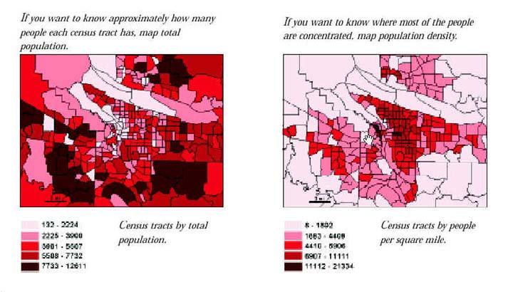
Why Is It There? Attribute Data Describe with statistics Analyze with hypothesis testing Spatial Data Describe with maps Analyze with spatial analysis
 6 Why Is It There? Why Is It There? Getting Started with Geographic Information Systems Chapter 6 6.1 Describing Attributes 6.2 Statistical Analysis 6.3 Spatial Description 6.4 Spatial Analysis 6.5 Searching
Resources for Spatial Thinking and Analysis
 Resources for Spatial Thinking and Analysis Donald G. Janelle Center for Spatially Integrated Social Science University of California, Santa Barbara New Orleans, 21 November 2002 Workshop on Spatial Analysis
Analyzing spatial autoregressive models using Stata
 Analyzing spatial autoregressive models using Stata David M. Drukker StataCorp Summer North American Stata Users Group meeting July 24-25, 2008 Part of joint work with Ingmar Prucha and Harry Kelejian
The GeoDa Book. Exploring Spatial Data. Luc Anselin
 The GeoDa Book Exploring Spatial Data Luc Anselin Copyright 2017 by GeoDa Press LLC All rights reserved. ISBN: 0-9863421-2-2 ISBN-13: 978-0-9863421-2-7 GeoDa Press LLC, Chicago, IL GeoDa TM is a trade
Improving Spatial Data Interoperability
 Improving Spatial Data Interoperability A Framework for Geostatistical Support-To To-Support Interpolation Michael F. Goodchild, Phaedon C. Kyriakidis, Philipp Schneider, Matt Rice, Qingfeng Guan, Jordan
The Link between GIS and spatial analysis. GIS, spatial econometrics and social science research
 J Geograph Syst (2000) 2:11±15 ( Springer-Verlag 2000 Part 2 The Link between GIS and spatial analysis GIS, spatial econometrics and social science research Luc Anselin Department of Agricultural and Consumer
Concepts and Applications of Kriging
 2013 Esri International User Conference July 8 12, 2013 San Diego, California Technical Workshop Concepts and Applications of Kriging Eric Krause Konstantin Krivoruchko Outline Intro to interpolation Exploratory
Finding Hot Spots in ArcGIS Online: Minimizing the Subjectivity of Visual Analysis. Nicholas M. Giner Esri Parrish S.
 Finding Hot Spots in ArcGIS Online: Minimizing the Subjectivity of Visual Analysis Nicholas M. Giner Esri Parrish S. Henderson FBI Agenda The subjectivity of maps What is Hot Spot Analysis? Why do Hot
Spatial Analysis I. Spatial data analysis Spatial analysis and inference
 Spatial Analysis I Spatial data analysis Spatial analysis and inference Roadmap Outline: What is spatial analysis? Spatial Joins Step 1: Analysis of attributes Step 2: Preparing for analyses: working with
Spatial Autocorrelation
 Spatial Autocorrelation Luc Anselin http://spatial.uchicago.edu spatial randomness positive and negative spatial autocorrelation spatial autocorrelation statistics spatial weights Spatial Randomness The
Soc/Anth 597 Spatial Demography March 14, GeoDa 0.95i Exercise A. Stephen A. Matthews. Outline. 1. Background
 Soc/Anth 597 Spatial Demography March 14, 2006 GeoDa 0.95i Exercise A Stephen A. Matthews Outline 1. Background 2. Data set introduced (GDANEPAL.SHP) 3. GeoDa introduced Task 1: Start GeoDa Task 2: Open
Statistical Perspectives on Geographic Information Science. Michael F. Goodchild University of California Santa Barbara
 Statistical Perspectives on Geographic Information Science Michael F. Goodchild University of California Santa Barbara Statistical geometry Geometric phenomena subject to chance spatial phenomena emphasis
Roger S. Bivand Edzer J. Pebesma Virgilio Gömez-Rubio. Applied Spatial Data Analysis with R. 4:1 Springer
 Roger S. Bivand Edzer J. Pebesma Virgilio Gömez-Rubio Applied Spatial Data Analysis with R 4:1 Springer Contents Preface VII 1 Hello World: Introducing Spatial Data 1 1.1 Applied Spatial Data Analysis
Outline. Introduction to SpaceStat and ESTDA. ESTDA & SpaceStat. Learning Objectives. Space-Time Intelligence System. Space-Time Intelligence System
 Outline I Data Preparation Introduction to SpaceStat and ESTDA II Introduction to ESTDA and SpaceStat III Introduction to time-dynamic regression ESTDA ESTDA & SpaceStat Learning Objectives Activities
Integrating Open-Source Statistical Packages with ArcGIS
 Esri International User Conference San Diego, California Technical Workshops 7-25-12 Integrating Open-Source Statistical Packages with ArcGIS Mark V. Janikas, Ph. D. Xing Kang Outline Introduction to Spatial
CyberGIS: What Still Needs to Be Done? Michael F. Goodchild University of California Santa Barbara
 CyberGIS: What Still Needs to Be Done? Michael F. Goodchild University of California Santa Barbara Progress to date Interoperable location referencing coordinate transformations geocoding addresses point-of-interest
EXPLORATORY SPATIAL DATA ANALYSIS IN A GEOCOMPUTATIONAL ENVIRONMENT
 EXPLORATORY SPATIAL DATA ANALYSIS IN A GEOCOMPUTATIONAL ENVIRONMENT Luc Anselin Regional Research Institute and Department of Economics West Virginia University P.O. Box 6825 Morgantown, WV 26506 lanselin@wvu.edu
SPATIAL ECONOMETRICS: METHODS AND MODELS
 SPATIAL ECONOMETRICS: METHODS AND MODELS STUDIES IN OPERATIONAL REGIONAL SCIENCE Folmer, H., Regional Economic Policy. 1986. ISBN 90-247-3308-1. Brouwer, F., Integrated Environmental Modelling: Design
Introduction to PySAL and Web Based Spatial Statistics
 1 Introduction to PySAL and Web Based Spatial Statistics Myung-Hwa Hwang GeoDa Center for Geospatial Analysis and Computation School of Geographical Sciences and Urban Planning Arizona State University
A GEOSTATISTICAL APPROACH TO PREDICTING A PHYSICAL VARIABLE THROUGH A CONTINUOUS SURFACE
 Katherine E. Williams University of Denver GEOG3010 Geogrpahic Information Analysis April 28, 2011 A GEOSTATISTICAL APPROACH TO PREDICTING A PHYSICAL VARIABLE THROUGH A CONTINUOUS SURFACE Overview Data
Using Spatial Statistics and Geostatistical Analyst as Educational Tools
 Using Spatial Statistics and Geostatistical Analyst as Educational Tools By Konrad Dramowicz Centre of Geographic Sciences Lawrencetown, Nova Scotia, Canada ESRI User Conference, San Diego, California
Applied Spatial Econometrics. Professor Bernard Fingleton Director of Research Department of Land Economy University of Cambridge
 Applied Spatial Econometrics Professor Bernard Fingleton Director of Research Department of Land Economy University of Cambridge Topics to discuss Regression and spatial dependence Residual Spatial autocorrelation
Community Health Needs Assessment through Spatial Regression Modeling
 Community Health Needs Assessment through Spatial Regression Modeling Glen D. Johnson, PhD CUNY School of Public Health glen.johnson@lehman.cuny.edu Objectives: Assess community needs with respect to particular
Spatial Relationships in Rural Land Markets with Emphasis on a Flexible. Weights Matrix
 Spatial Relationships in Rural Land Markets with Emphasis on a Flexible Weights Matrix Patricia Soto, Lonnie Vandeveer, and Steve Henning Department of Agricultural Economics and Agribusiness Louisiana
Using AMOEBA to Create a Spatial Weights Matrix and Identify Spatial Clusters, and a Comparison to Other Clustering Algorithms
 Using AMOEBA to Create a Spatial Weights Matrix and Identify Spatial Clusters, and a Comparison to Other Clustering Algorithms Arthur Getis* and Jared Aldstadt** *San Diego State University **SDSU/UCSB
What s special about spatial data?
 What s special about spatial data? Road map Geographic Information analysis The need to develop spatial thinking Some fundamental geographic concepts (PBCS) What are the effects of space? Spatial autocorrelation
Spatial Analysis with ArcGIS Pro STUDENT EDITION
 Spatial Analysis with ArcGIS Pro STUDENT EDITION Copyright 2018 Esri All rights reserved. Course version 2.0. Version release date November 2018. Printed in the United States of America. The information
Overview of Statistical Analysis of Spatial Data
 Overview of Statistical Analysis of Spatial Data Geog 2C Introduction to Spatial Data Analysis Phaedon C. Kyriakidis www.geog.ucsb.edu/ phaedon Department of Geography University of California Santa Barbara
OPEN GEODA WORKSHOP / CRASH COURSE FACILITATED BY M. KOLAK
 OPEN GEODA WORKSHOP / CRASH COURSE FACILITATED BY M. KOLAK WHAT IS GEODA? Software program that serves as an introduction to spatial data analysis Free Open Source Source code is available under GNU license
Computing the Jacobian in Gaussian spatial models: an illustrated comparison of available methods
 Computing the Jacobian in Gaussian spatial models: an illustrated comparison of available methods 1 1 1 1 1 1 Abstract When fitting spatial regression models by maximum likelihood using spatial weights
LEHMAN COLLEGE CITY UNIVERSITY OF NEW YORK DEPARTMENT OF ENVIRONMENTAL, GEOGRAPHIC, AND GEOLOGICAL SCIENCES CURRICULAR CHANGE
 LEHMAN COLLEGE CITY UNIVERSITY OF NEW YORK DEPARTMENT OF ENVIRONMENTAL, GEOGRAPHIC, AND GEOLOGICAL SCIENCES CURRICULAR CHANGE Hegis Code: 2206.00 Program Code: 452/2682 1. Type of Change: New Course 2.
Spatial Analysis 2. Spatial Autocorrelation
 Spatial Analysis 2 Spatial Autocorrelation Spatial Autocorrelation a relationship between nearby spatial units of the same variable If, for every pair of subareas i and j in the study region, the drawings
Concepts and Applications of Kriging. Eric Krause Konstantin Krivoruchko
 Concepts and Applications of Kriging Eric Krause Konstantin Krivoruchko Outline Introduction to interpolation Exploratory spatial data analysis (ESDA) Using the Geostatistical Wizard Validating interpolation
Spatial Trends of unpaid caregiving in Ireland
 Spatial Trends of unpaid caregiving in Ireland Stamatis Kalogirou 1,*, Ronan Foley 2 1. NCG Affiliate, Thoukididi 20, Drama, 66100, Greece; Tel: +30 6977 476776; Email: skalogirou@gmail.com; Web: http://www.gisc.gr.
SPATIAL PANEL ECONOMETRICS
 Chapter 18 SPATIAL PANEL ECONOMETRICS Luc Anselin University of Illinois, Urbana-Champaign Julie Le Gallo Universit«e Montesquieu-Bordeaux IV Hubert Jayet Universit«e de Lille 1. Introduction Spatial econometrics
Concepts and Applications of Kriging
 Esri International User Conference San Diego, California Technical Workshops July 24, 2012 Concepts and Applications of Kriging Konstantin Krivoruchko Eric Krause Outline Intro to interpolation Exploratory
Spatial Statistics For Real Estate Data 1
 1 Key words: spatial heterogeneity, spatial autocorrelation, spatial statistics, geostatistics, Geographical Information System SUMMARY: The paper presents spatial statistics tools in application to real
Rate Maps and Smoothing
 Rate Maps and Smoothing Luc Anselin Spatial Analysis Laboratory Dept. Agricultural and Consumer Economics University of Illinois, Urbana-Champaign http://sal.agecon.uiuc.edu Outline Mapping Rates Risk
Spatial Filtering with EViews and MATLAB
 AUSTRIAN JOURNAL OF STATISTICS Volume 36 (2007), Number 1, 17 26 Spatial Filtering with EViews and MATLAB Robert Ferstl Vienna University of Economics and Business Administration Abstract: This article
BAYESIAN MODEL FOR SPATIAL DEPENDANCE AND PREDICTION OF TUBERCULOSIS
 BAYESIAN MODEL FOR SPATIAL DEPENDANCE AND PREDICTION OF TUBERCULOSIS Srinivasan R and Venkatesan P Dept. of Statistics, National Institute for Research Tuberculosis, (Indian Council of Medical Research),
KAAF- GE_Notes GIS APPLICATIONS LECTURE 3
 GIS APPLICATIONS LECTURE 3 SPATIAL AUTOCORRELATION. First law of geography: everything is related to everything else, but near things are more related than distant things Waldo Tobler Check who is sitting
Spatial Data, Spatial Analysis and Spatial Data Science
 Spatial Data, Spatial Analysis and Spatial Data Science Luc Anselin http://spatial.uchicago.edu 1 spatial thinking in the social sciences spatial analysis spatial data science spatial data types and research
Political Science 867 Spatial Modeling Winter N Derby Hall Phone: (614)
") Political Science 867 Spatial Modeling Winter 2005 Professor David Darmofal E-mail: darmofal.3@osu.edu 2049N Derby Hall Phone: (614) 292-5358 Ohio State University Office Hours (CST): MTW 12-1, F 2-4,
Political Science 867 Spatial Modeling Winter 2005 Professor David Darmofal E-mail: darmofal.3@osu.edu 2049N Derby Hall Phone: (614) 292-5358 Ohio State University Office Hours (CST): MTW 12-1, F 2-4,
Application of Spatial Regression Models to Income Poverty Ratios in Middle Delta Contiguous Counties in Egypt
 Application of Spatial Regression Models to Income Poverty Ratios in Middle Delta Contiguous Counties in Egypt Sohair F Higazi Dept. Applied Statistics Faculty of Commerce, Tanta University, Tanta, Egypt
Geographical Information Systems Institute. Center for Geographic Analysis, Harvard University. GeoDa: Spatial Autocorrelation
 Geographical Information Systems Institute, A. Background From geodacenter.asu.edu: GeoDa is a free software program that serves as an introduction to spatial data analysis. OpenGeoDa is the cross-platform,
SPACE Workshop Santa Barbara, California July 2007
 SPACE Workshop Santa Barbara, California 15 20 July 2007 Modeling a Center for Spatially Integrated Social Science Critical Themes in Social Science + Tools and Concepts for Spatial Thinking + Infrastructure
Lecture 8. Spatial Estimation
 Lecture 8 Spatial Estimation Lecture Outline Spatial Estimation Spatial Interpolation Spatial Prediction Sampling Spatial Interpolation Methods Spatial Prediction Methods Interpolating Raster Surfaces
Network data in regression framework
 13-14 July 2009 University of Salerno (Italy) Network data in regression framework Maria ProsperinaVitale Department of Economics and Statistics University of Salerno (Italy) mvitale@unisa.it - Theoretical
RAO s SCORE TEST IN SPATIAL ECONOMETRICS
 RAO s SCORE TEST IN SPATIAL ECONOMETRICS Luc Anselin Regional Economics Applications Laboratory (REAL) and Department of Agricultural and Consumer Economics University of Illinois, Urbana-Champaign Urbana,
POPULAR CARTOGRAPHIC AREAL INTERPOLATION METHODS VIEWED FROM A GEOSTATISTICAL PERSPECTIVE
 CO-282 POPULAR CARTOGRAPHIC AREAL INTERPOLATION METHODS VIEWED FROM A GEOSTATISTICAL PERSPECTIVE KYRIAKIDIS P. University of California Santa Barbara, MYTILENE, GREECE ABSTRACT Cartographic areal interpolation
Spatial Autocorrelation and Random Effects in Digitizing Error
 Proceedings of the 8th International Symposium on Spatial Accuracy Assessment in Natural Resources and Environmental Sciences Shanghai, P. R. China, June 25-27, 2008, pp. 94-102 Spatial Autocorrelation
Geostatistics and Spatial Scales
 Geostatistics and Spatial Scales Semivariance & semi-variograms Scale dependence & independence Ranges of spatial scales Variable dependent Fractal dimension GIS implications Spatial Modeling Spatial Analysis
Chapter 6 Spatial Analysis
 6.1 Introduction Chapter 6 Spatial Analysis Spatial analysis, in a narrow sense, is a set of mathematical (and usually statistical) tools used to find order and patterns in spatial phenomena. Spatial patterns