GIS and Demography. John R. Weeks Professor of Geography and Director International Population Center
|
|
|
- Deirdre Richards
- 5 years ago
- Views:
Transcription


1 GIS and Demography John R. Weeks Professor of Geography and Director International Population Center Introduction to Spatial Pattern Analysis in a GIS Environment Center for Spatially Integrated Social Science University of California, Santa Barbara June 2004
2
3

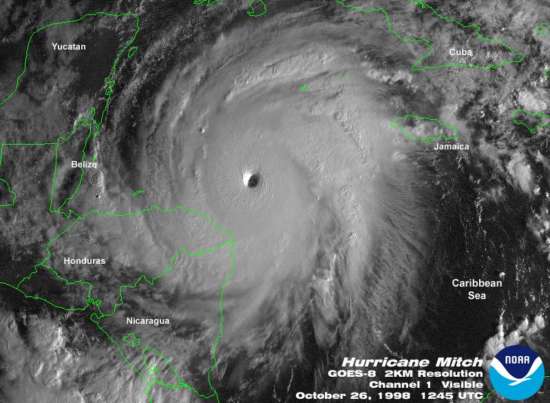
4 Uhsan, Honduras Virtually everyone has suffered forever from parasites because of contaminated water

5 A long and difficult labor in which the baby and mother might well have died without the intervention of the volunteer physician from Mexico

6 5-month old girl who survived a strangulated umbilical hernia because volunteer workers took her by canoe to a health clinic in a town on the coast

7 These acts of mercy and kindness represent the beginning of what?
8 The Demographic Transition Population size Epidemiological transition Fertility transition
9 First, we need to keep in mind that population growth is not really like an explosion...
10 ...it is really more like a thunderstorm. And like a thunderstorm it occurs locally, even if it has regional and global effects.
11 This local aspect of demography is what gives rise to its spatial dimension and lends it so nicely to analysis in a GIS environment.
12 Demography is inherently spatial, despite the emphasis on individual-level survey data over the past several decades (but note that DHS has georeferenced its survey data since 1999). Demography is also inherently interdisciplinary. The The power of GIS has produced a renaissance in models of human behavior that place people in the environmental context of space and time a new version of human ecology.
13 Spatial dimensions of the components of the demographic transition Epidemiological transition Fertility transition Age transition Migration transition Urban transition Household/family transition
14 Spatial awareness location matters in some general way. Spatial analysis measures the contribution of location to our understanding of human behavior; spatial dependence (especially clustering) as a predictive variable rather than a problem.
15 General Model of the Interaction of Spatial Context and Demography Spatial context: Where you are and to whom you are connected Human and social capital available at the local level: Who you are Proximate determinants of demographic behavior Change in demographic behavior
16 Family of Analysis Neighborhood/local: environmental context Network/connection: diffusion and dispersal Demographic Applications Differences and inequalities in fertility, mortality, age structure, family and household structure Diffusion of ideas about family size and methods of fertility control; of methods for preventing and curing illness; of information about costs and benefits of migration Migration patterns between specific places
17 Data considerations for spatial analysis in demography Data must be geo-referenced Point data (x,y) permit PPA Polygon Polygon data permit APA Or assign centroids and do PPA MAUP--includes scale and zone effects

18 Scale effect: different results can be obtained from the same statistical analysis at different levels of spatial resolution. Zoning effect: different boundaries can produce different results because of the capture of different people within different zones.

19 A Framework for Spatial Analysis in Poverty and Food Security Research (prepared for the United Nations Food & Agricultural Organization) Type of Analysis Neighborhood/local: environmental context Network/connection: diffusion and dispersal Applications Differences and inequalities in food security, family and household structure, sources and levels of income, political and economic stability Diffusion of ideas about nutrition; information about costs and benefits of econ develop, migration or other strategies for alleviating poverty Migration patterns between places in order to alleviate poverty
20 Resource: John R. Weeks, The Role of Spatial Analysis in Demographic Research, Ch. 19 in Michael F. Goodchild and Donald G. Janelle (eds.), Spatially Integrated Social Science: Examples in Best Practice (New York: Oxford University Press), Can be accessed at: Aftweb/AFT-main.htm
21 Final question: What does this map represent?
The Spatial Perspective
 Department of Geography University of California at Santa Barbara GEOGRAPHY 5 MIDTERM REVIEW SHEET The Spatial Perspective - Review all of chapter 1 carefully except for Box 1.B (but do review Box 1.A
The Case for Space in the Social Sciences
 The Case for Space in the Social Sciences Don Janelle Center for Spatially Integrated Social Science University of California, Santa Barbara Roundtable on Geographical Voices and Geographical Analysis
Space-adjusting Technologies and the Social Ecologies of Place
 Space-adjusting Technologies and the Social Ecologies of Place Donald G. Janelle University of California, Santa Barbara Reflections on Geographic Information Science Session in Honor of Michael Goodchild
CSISS Resources for Research and Teaching
 CSISS Resources for Research and Teaching Donald G. Janelle Center for Spatially Integrated Social Science University of California, Santa Barbara Montreal 26 July 2003 Workshop on Spatial Analysis for
Medical GIS: New Uses of Mapping Technology in Public Health. Peter Hayward, PhD Department of Geography SUNY College at Oneonta
 Medical GIS: New Uses of Mapping Technology in Public Health Peter Hayward, PhD Department of Geography SUNY College at Oneonta Invited research seminar presentation at Bassett Healthcare. Cooperstown,
Studying Populations I
 Exercise 1 Human Adaptation (cultural ecology) Discuss how the regional physical geography influenced the development of unique cultural traits in two distinct areas of the world. GRADE DISTRIBUTION 11
Population Profiles
 U N D E R S T A N D I N G A N D E X P L O R I N G D E M O G R A P H I C C H A N G E MAPPING AMERICA S FUTURES, BRIEF 6 2000 2010 Population Profiles Atlanta, Las Vegas, Washington, DC, and Youngstown Allison
Section III: Poverty Mapping Results
 Section III: Poverty Mapping Results Figure 5: Gewog level rural poverty map 58. The most prominent result from the poverty mapping exercise of Bhutan is the production of a disaggregated poverty headcount
Resources for Spatial Thinking and Analysis
 Resources for Spatial Thinking and Analysis Donald G. Janelle Center for Spatially Integrated Social Science University of California, Santa Barbara New Orleans, 21 November 2002 Workshop on Spatial Analysis
Spatial Analysis 1. Introduction
 Spatial Analysis 1 Introduction Geo-referenced Data (not any data) x, y coordinates (e.g., lat., long.) ------------------------------------------------------ - Table of Data: Obs. # x y Variables -------------------------------------
Department of Geography University of California at Santa Barbara
 Department of Geography University of California at Santa Barbara GEOGRAPHY 5 FINAL EXAM REVIEW SHEET Exam specifics and structure 2 hours, 50 minutes Bring a pink parscore sheet, a bluebook, a pen and
In April of 1949 the Population Commission of the Economic
 ANNOTATIONS THE DETERMINANTS AND CONSEQUENCES OF POPULATION TRENDS In April of 1949 the Population Commission of the Economic and Social Council of the United Nations recommended that.. the Secretary-General
GEOGRAPHY (GEG) Geography (GEG) 1
 Geography (GEG) 1") Geography (GEG) 1 GEOGRAPHY (GEG) GEG 101. Digital Earth. 3 Credit Hours. Explores various geospatial technologies and the societal implications of our digital world with particular emphasis locational
Geography (GEG) 1 GEOGRAPHY (GEG) GEG 101. Digital Earth. 3 Credit Hours. Explores various geospatial technologies and the societal implications of our digital world with particular emphasis locational
Advanced Placement Human Geography
 Advanced Placement Human Geography I. Overview of the Course The purpose of the Advanced Placement (AP) Human Geography course is to introduce students to the systematic study of patterns and processes
A spatial literacy initiative for undergraduate education at UCSB
 A spatial literacy initiative for undergraduate education at UCSB Mike Goodchild & Don Janelle Department of Geography / spatial@ucsb University of California, Santa Barbara ThinkSpatial Brown bag forum
International Development
 International Development Discipline/Multi-discipline or trans-disciplinary field Tahmina Rashid Associate Professor, International Studies What is Development? a. Development as a state or condition-static
UNIVERSITY OF KWAZULU-NATAL EXAMINATION: JUNE 2012 Howard College and Westville Campuses
 UNIVERSITY OF KWAZULU-NATAL EXAMINATION: JUNE 2012 Howard College and Westville Campuses SCHOOL : AGRICULTURE, EARTH AND ENVIRONMENTAL SCIENCES LEVEL : 1 MODULE : HUMAN ENVIRONMENTS CODE : GEOG 110 H1/W1
Geospatial Technologies for Resources Planning & Management
 Geospatial Technologies for Resources Planning & Management Lal Samarakoon, PhD Director, Geoinformatics Center Asian Institute of Technology, Thailand Content Geoinformatics for SDG Information Integration
Integrating GIS into Food Access Analysis
 GIS Day at Kansas University Integrating GIS into Food Access Analysis Daoqin Tong School of Geography and Development Outline Introduction Research questions Method Results Discussion Introduction Food
Apéndice 1: Figuras y Tablas del Marco Teórico
 Apéndice 1: Figuras y Tablas del Marco Teórico FIGURA A.1.1 Manufacture poles and manufacture regions Poles: Share of employment in manufacture at least 12% and population of 250,000 or more. Regions:
Evaluating Community Analyst for Use in School Demography Studies
 Portland State University PDXScholar Publications, Reports and Presentations Population Research Center 7-2013 Evaluating Community Analyst for Use in School Demography Studies Richard Lycan Portland State
Urban Foundations. Early American Cities. Early American Cities. Early American Cities. Cities in America to 1945
 Urban Foundations Cities in America to 1945 Early American Cities The design of early American cities was highly influenced by European traditions The roots of many of these traditions can in turn be traced
Summary Article: Poverty from Encyclopedia of Geography
 Topic Page: Poverty Definition: poverty from Dictionary of Energy Social Issues. the fact of being poor; the absence of wealth. A term with a wide range of interpretations depending on which markers of
MIGRATION, URBANIZATION, AND DEVELOPMENT -COURSE DESCRIPTION- (Revised: August 16, 1993)
") Geog./Econ;.: 4293/5293 Migration, Urbanization, and Development Fall 1993 - MWF 9:00-9:50 Guggenheim 2 Mr. A. Rogers and Mr. C. Becker MIGRATION, URBANIZATION, AND DEVELOPMENT -COURSE DESCRIPTION- (Revised:
Geog./Econ;.: 4293/5293 Migration, Urbanization, and Development Fall 1993 - MWF 9:00-9:50 Guggenheim 2 Mr. A. Rogers and Mr. C. Becker MIGRATION, URBANIZATION, AND DEVELOPMENT -COURSE DESCRIPTION- (Revised:
Disaster Management & Recovery Framework: The Surveyors Response
 Disaster Management & Recovery Framework: The Surveyors Response Greg Scott Inter-Regional Advisor Global Geospatial Information Management United Nations Statistics Division Department of Economic and
BIG IDEAS. Area of Learning: SOCIAL STUDIES Urban Studies Grade 12. Learning Standards. Curricular Competencies
 Area of Learning: SOCIAL STUDIES Urban Studies Grade 12 BIG IDEAS Urbanization is a critical force that shapes both human life and the planet. The historical development of cities has been shaped by geographic,
A Framework for the Study of Urban Health. Abdullah Baqui, DrPH, MPH, MBBS Johns Hopkins University
 This work is licensed under a Creative Commons Attribution-NonCommercial-ShareAlike License. Your use of this material constitutes acceptance of that license and the conditions of use of materials on this
Emergent Geospatial Data & Measurement Issues
 CUNY Institute for Demographic Research Emergent Geospatial Data & Measurement Issues Deborah Balk CUNY Institute for Demographic Research (CIDR) & School of Public Affairs, Baruch College City University
Topic 4: Changing cities
 Topic 4: Changing cities Overview of urban patterns and processes 4.1 Urbanisation is a global process a. Contrasting trends in urbanisation over the last 50 years in different parts of the world (developed,
Stability, Ability and Equity
 Stability, Ability and Equity Mobility and Protection in the Urban Context Arup Banerji Senior Director and Head of Global Practice, Social Protection and Labor The World Bank Group 1 ECONOMIC MOBILITY
Health and Medical Geography (GEOG 222)
") Spring 2019 Class meets: Tuesdays and Thursdays 12:30-1:45pm Carolina Hall Room 220 Instructor: Michael Emch Email: emch@unc.edu Course Objectives Health and Medical Geography (GEOG 222) This course is
Spring 2019 Class meets: Tuesdays and Thursdays 12:30-1:45pm Carolina Hall Room 220 Instructor: Michael Emch Email: emch@unc.edu Course Objectives Health and Medical Geography (GEOG 222) This course is
CARIBBEAN POPULATION AND DEVELOPMENT TRENDS AND INTERRELATIONS: A ASSESSMENT VOLUME 1
 LC/CAR/G.352 ECONOMIC COMMISSION FOR LATIN AMERICA AND THE CARIBBEAN Subregional Headquarters for the Caribbean ECLAC/CELADE DEMOGRAPHY UNIT jc:.'arlv'- H. CARIBBEAN POPULATION AND DEVELOPMENT TRENDS AND
AP Human Geography. Additional materials, including case studies, videos, and aerial photos, will be used to supplement primary course materials.
 Course Introduction AP Human Geography is a yearlong college-level course designed to prepare students for the Advanced Placement (AP) Human Geography Exam. The course focuses on the study of human populations
ACCESSIBILITY TO SERVICES IN REGIONS AND CITIES: MEASURES AND POLICIES NOTE FOR THE WPTI WORKSHOP, 18 JUNE 2013
 ACCESSIBILITY TO SERVICES IN REGIONS AND CITIES: MEASURES AND POLICIES NOTE FOR THE WPTI WORKSHOP, 18 JUNE 2013 1. Significant differences in the access to basic and advanced services, such as transport,
AP Human Geography. Course Outline Geography: Its Nature and Perspectives: Weeks 1-4
 AP Human Geography The Course The AP Human Geography course is designed to provide secondary students with the equivalent of one semester of a college introductory human geography class. The purpose of
AP Human Geography. Course Materials
 AP Human Geography This is a syllabus for a two semester Advanced Placement Human Geography course that has been offered for several years at this school. The material covered is based on the AP Human
AAG CENTER FOR GLOBAL GEOGRAPHY EDUCATION Internationalizing the Teaching and Learning of Geography
 Using the CGGE Materials in Advanced Placement Human Geography Classes About the CGGE: The AAG Center for Global Geography Education (CGGE) is a collection of online modules for undergraduate courses in
GLOBAL PERSPECTIVES IN HEALTH Vol. II - Urban Growth and Health - Yola L.G. Verhasselt
 URBAN GROWTH AND HEALTH Yola L.G. Verhasselt Geografisch Instituut, Vrije Universiteit Brussel, Belgium Keywords: Urbanization, city size, urban growth, health, health transition, environment Contents
Poverty statistics in Mongolia
 HIGH-LEVEL SEMINAR ON HARMONISATION OF POVERTY STATISTICS IN CIS COUNTRIES SOCHI (RUSSIAN FEDERATION) Poverty statistics in Mongolia Oyunchimeg Dandar Director Population and Social Statistics Department,
A Comprehensive Method for Identifying Optimal Areas for Supermarket Development. TRF Policy Solutions April 28, 2011
 A Comprehensive Method for Identifying Optimal Areas for Supermarket Development TRF Policy Solutions April 28, 2011 Profile of TRF The Reinvestment Fund builds wealth and opportunity for lowwealth communities
Geography - Grade 8. Unit A - Global Settlement: Patterns and Sustainability
 Geography - Grade 8 Geographical Thinking: Spatial Significance Patterns and Trends Interrelationships Geographic Perspective Geographic Inquiry: STEP 1 - Formulate Questions STEP 2 - Gather and Organize
Presented at ESRI Education User Conference, July 6-8, 2001, San Diego, CA
 Presented at ESRI Education User Conference, July 6-8, 2001, San Diego, CA Irina V. Sharkova, Ph.D., Research Assistant Professor Richard Lycan, Ph.D., Senior Research Associate Population Research Center
Maggie M. Kovach. Department of Geography University of North Carolina at Chapel Hill
 Maggie M. Kovach Department of Geography University of North Carolina at Chapel Hill Rationale What is heat-related illness? Why is it important? Who is at risk for heat-related illness and death? Urban
CONSTRUCTING THE POVERTY AND OPPORTUNITIES/PUBLIC SERVICES MAPS INFORMATION MANAGEMENT. Background: Brazil Without Extreme Poverty Plan
 INFORMATION MANAGEMENT CONSTRUCTING THE POVERTY AND OPPORTUNITIES/PUBLIC SERVICES MAPS Background: Brazil Without Extreme Poverty Plan The Brazil Without Extreme Poverty Plan (BSM), designed to overcome
Techniques for Science Teachers: Using GIS in Science Classrooms.
 Techniques for Science Teachers: Using GIS in Science Classrooms. After ESRI, 2008 GIS A Geographic Information System A collection of computer hardware, software, and geographic data used together for
European Regional and Urban Statistics
 European Regional and Urban Statistics Dr. Berthold Feldmann berthold.feldmann@ec.europa.eu Eurostat Structure of the talk Regional statistics in the EU The tasks of Eurostat Regional statistics Urban
Dublin City Schools Social Studies Graded Course of Study Grade 5 K-12 Social Studies Vision
 K-12 Social Studies Vision The Dublin City Schools K-12 Social Studies Education will provide many learning opportunities that will help students to: develop thinking as educated citizens who seek to understand
International Development
 International Development Office: The Payson Center for International Development and Technology Transfer, 300 Hébert Hall Phone: 504-865-5240 Fax: 504-865-5241 Website: www.payson.tulane.edu/ Program
Curriculum Unit. Instructional Unit #1
 Curriculum Unit Name of Course: AP Human Geography Grade Level(s): 9-12 Brief Description (Course Catalog): The purpose of the AP Human Geography course is to introduce students to the systematic study
Frans Thissen Department of Geography, Planning and International Development Studies Rural Poverty in Flanders
 Frans Thissen Department of Geography, Planning and International Development Studies Rural Poverty in Flanders a diversity of poverty in a diversity of places Rural poverty research in Flanders Henk Meert
Population Research Center (PRC) Oregon Population Forecast Program
 Oregon Population Forecast Program") Population Research Center (PRC) Oregon Population Forecast Program 2013 Oregon League of Cities Conference Risa S. Proehl Jason R. Jurjevich, Ph.D. Population Research Center (PRC) Population Research
Population Research Center (PRC) Oregon Population Forecast Program 2013 Oregon League of Cities Conference Risa S. Proehl Jason R. Jurjevich, Ph.D. Population Research Center (PRC) Population Research
Human Health in Arctic Russia: A Concept of National Monitoring Program
 Human Health in Arctic Russia: A Concept of National Monitoring Program By Northwest Public Health Research Center, St. Petersburg in collaboration with the AMAP Human Health Expert Group; Arctic policy
Foundation Geospatial Information to serve National and Global Priorities
 Foundation Geospatial Information to serve National and Global Priorities Greg Scott Inter-Regional Advisor Global Geospatial Information Management United Nations Statistics Division UN-GGIM: A global
SOCIO-DEMOGRAPHIC INDICATORS FOR REGIONAL POPULATION POLICIES
 SOCIO-DEMOGRAPHIC INDICATORS FOR REGIONAL POPULATION POLICIES A CANADIAN PERSPECTIVE Marc Termote Université de Montréal Potsdam, DART Conference, September 3, 2012 3 STEPS 1. Defining the problem 2. Identifying
The Importance of Spatial Literacy
 The Importance of Spatial Literacy Dr. Michael Phoenix GIS Education Consultant Taiwan, 2009 What is Spatial Literacy? Spatial Literacy is the ability to be able to include the spatial dimension in our
Switching to AQA from Edexcel: Draft Geography AS and A-level (teaching from September 2016)
") Switching to AQA from Edexcel: Draft Geography AS and A-level (teaching from September 2016) If you are thinking of switching from OCR to AQA (from September 2016), this resource is an easy reference guide.
Switching to AQA from Edexcel: Draft Geography AS and A-level (teaching from September 2016) If you are thinking of switching from OCR to AQA (from September 2016), this resource is an easy reference guide.
3. What is the etymology (how the word came to be) of geography. 4. How does the study of physical geography differ from that of human geography?
 of geography. 4. How does the study of physical geography differ from that of human geography?") AP Human Geography Unit 1: Basic Concepts and Development Guided Reading Mr. Stepek Directions: Follow the common directions distributed to you for guided reading assignments. Rubenstein p 2 5 (Introduction)
AP Human Geography Unit 1: Basic Concepts and Development Guided Reading Mr. Stepek Directions: Follow the common directions distributed to you for guided reading assignments. Rubenstein p 2 5 (Introduction)
Approach to identifying hot spots for NCDs in South Africa
 Approach to identifying hot spots for NCDs in South Africa HST Conference 6 May 2016 Noluthando Ndlovu, 1 Candy Day, 1 Benn Sartorius, 2 Karen Hofman, 3 Jens Aagaard-Hansen 3,4 1 Health Systems Trust,
Introduction to Human Geography. Unit 1: It s Nature and Perspective
 Introduction to Human Geography Unit 1: It s Nature and Perspective Questions that Geography addresses: Where are things located? Why are they important? How are places related? How are places connected?
Telling Stories with Numbers Secondary data collection, presentation, and interpretation
 10/10/2013 Telling Stories with Numbers Secondary data collection, presentation, and interpretation Vincent Adams Coordinator, Rural Communities Explorer Oregon State University www.oregonexplorer.info/rural
Alleghany County Schools Curriculum Guide GRADE/COURSE: World Geography
 GRADE/COURSE: World 2013-14 GRADING PERIOD: 1 st Six Weeks Time Frame Unit/SOLs SOL # Strand Resource Assessment 8 days* The student will use maps, globes, satellite images, photographs, or diagrams to
School of Geography and Geosciences. Head of School Degree Programmes. Programme Requirements. Modules. Geography and Geosciences 5000 Level Modules
 School of Geography and Geosciences Head of School Degree Programmes Graduate Diploma: Dr W E Stephens Health Geography Research Environmental History and Policy (see School of History) M.Res.: M.Litt.:
SPACE Workshop NSF NCGIA CSISS UCGIS SDSU. Aldstadt, Getis, Jankowski, Rey, Weeks SDSU F. Goodchild, M. Goodchild, Janelle, Rebich UCSB
 SPACE Workshop NSF NCGIA CSISS UCGIS SDSU Aldstadt, Getis, Jankowski, Rey, Weeks SDSU F. Goodchild, M. Goodchild, Janelle, Rebich UCSB August 2-8, 2004 San Diego State University Some Examples of Spatial
AP Human Geography Unit 1: Basic Concepts and Development Mr. Stepek Guided Reading/Study Guide
 AP Human Geography Unit 1: Basic Concepts and Development Mr. Stepek Guided Reading/Study Guide Directions: Follow the common directions distributed to you for guided reading assignments. Rubenstein p
A.P. Human Geography
 A.P. Human Geography 2012-2013 Instructor: Chris Vitt Brief Description of Course AP Human Geography is designed to provide students with a learning experience equivalent to that obtained in most college
Planning Road Networks in New Cities Using GIS: The Case of New Sohag, Egypt
 Planning Road Networks in New Cities Using GIS: The Case of New Sohag, Egypt Mostafa Abdel-Bary Ebrahim, Egypt Ihab Yehya Abed-Elhafez, Kingdom of Saudi Arabia Keywords: Road network evaluation; GIS, Spatial
SPACE Workshop Santa Barbara, California July 2007
 SPACE Workshop Santa Barbara, California 15 20 July 2007 Modeling a Center for Spatially Integrated Social Science Critical Themes in Social Science + Tools and Concepts for Spatial Thinking + Infrastructure
POPULATION AND DEVELOPMENT: CHALLENGES AND OPPORTUNITIES
 CONTENTS POPULATION AND DEVELOPMENT: CHALLENGES AND OPPORTUNITIES Population and Development: Challenges and Opportunities - Volume 1 No. of Pages: 416 ISBN: 978-1-84826-086-3 (ebook) ISBN: 978-1-84826-536-3
Population CHAPTER. Learning Outcomes. Where is the world s population distributed?
 CHAPTER 2 Population Learning Outcomes Where is the world s population distributed? 2.1.1: Identify the four regions where most of the world s human inhabitants are clustered. 2.1.2: List the main reasons
GIS and Health Geography. What is epidemiology?
 GIS and Health Geography { What is epidemiology? TOC GIS and health geography Major applications for GIS Epidemiology What is health (and how location matters) What is a disease (and how to identify one)
Delta School District 1
 Delta School District Social Studies Curriculum Scope and Sequence K-12 GLE Principles of Constitutional Democracy K 1 2 3 4 5 6 7 8 9-12 1. Knowledge of the principles expressed in documents shaping constitutional
Data Requirements in Multidimensional Poverty Measurement
 Data Requirements in Multidimensional Poverty Measurement Oxford Poverty & Human Development Initiative (OPHI) University of Oxford Rabat, 4 June 2014 Limits of the current global MPI surveys: DHS, MICS
CHAPTER 2: KEY ISSUE 1 Where Is the World s Population Distributed? p
 CHAPTER 2: KEY ISSUE 1 Where Is the World s Population Distributed? p. 45-49 Always keep your vocabulary packet out whenever you take notes. As the term comes up in the text, add to your examples for the
MULTIPLE CHOICE. Choose the one alternative that best completes the statement or answers the question.
 Exam Name MULTIPLE CHOICE. Choose the one alternative that best completes the statement or answers the question. 1) One important feature of the world's population with the most significant future implications
11/14/2017. Key City Focus: Phoenix
 Semester Project Reminder Semester Project presentations begin on Monday, November 20 (and continue on Monday, November 27 and Wednesday, November 27). See the presentation schedule posted online for your
ENV208/ENV508 Applied GIS. Week 1: What is GIS?
 ENV208/ENV508 Applied GIS Week 1: What is GIS? 1 WHAT IS GIS? A GIS integrates hardware, software, and data for capturing, managing, analyzing, and displaying all forms of geographically referenced information.
Spatial Trends of unpaid caregiving in Ireland
 Spatial Trends of unpaid caregiving in Ireland Stamatis Kalogirou 1,*, Ronan Foley 2 1. NCG Affiliate, Thoukididi 20, Drama, 66100, Greece; Tel: +30 6977 476776; Email: skalogirou@gmail.com; Web: http://www.gisc.gr.
Rural Sociology (RU_SOC)
") Rural Sociology (RU_SOC) 1 Rural Sociology (RU_SOC) RU_SOC 1000: Rural Sociology Introduction to basic concepts and principles of sociology with a focus on rural populations and places. The course explores
Rural Sociology (RU_SOC) 1 Rural Sociology (RU_SOC) RU_SOC 1000: Rural Sociology Introduction to basic concepts and principles of sociology with a focus on rural populations and places. The course explores
Demographic Data in ArcGIS. Harry J. Moore IV
 Demographic Data in ArcGIS Harry J. Moore IV Outline What is demographic data? Esri Demographic data - Real world examples with GIS - Redistricting - Emergency Preparedness - Economic Development Next
Where Do Overweight Women In Ghana Live? Answers From Exploratory Spatial Data Analysis
 Where Do Overweight Women In Ghana Live? Answers From Exploratory Spatial Data Analysis Abstract Recent findings in the health literature indicate that health outcomes including low birth weight, obesity
AP Human Geography Syllabus
 AP Human Geography Syllabus Textbook The Cultural Landscape: An Introduction to Human Geography. Rubenstein, James M. 10 th Edition. Upper Saddle River, N.J.: Prentice Hall 2010 Course Objectives This
The Cultural Landscape: An Introduction to Human Geography, 10e (Rubenstein) Chapter 2 Population
 Chapter 2 Population") The Cultural Landscape: An Introduction to Human Geography, 10e (Rubenstein) Chapter 2 Population 1) One important feature of the world's population with the most significant future implications is that
The Cultural Landscape: An Introduction to Human Geography, 10e (Rubenstein) Chapter 2 Population 1) One important feature of the world's population with the most significant future implications is that
Johns Hopkins University Fall APPLIED ECONOMICS Regional Economics
 Johns Hopkins University Fall 2017 Applied Economics Sally Kwak APPLIED ECONOMICS 440.666 Regional Economics In this course, we will develop a coherent framework of theories and models in the field of
APPENDIX PHASE 1 GREEN INFRASTRUCTURE FRAMEWORK
 APPENDIX PHASE 1 GREEN INFRASTRUCTURE FRAMEWORK KANSAS MISSOURI CONTENTS A DATA WISHLIST 4 B PRECEDENTS 7 C WORKSHOP MATERIALS 13 D ANALYSIS PROCESS 124 E ATLAS & PLAYBOOK DETAILS 156 F POLICY ANALYSIS
Technical Track Session I: Causal Inference
 Impact Evaluation Technical Track Session I: Causal Inference Human Development Human Network Development Network Middle East and North Africa Region World Bank Institute Spanish Impact Evaluation Fund
AP HUG REVIEW WELCOME TO 2 ND SEMESTER! Annette Parkhurst, M.Ed. January, 2015
 AP HUG REVIEW WELCOME TO 2 ND SEMESTER! Annette Parkhurst, M.Ed. January, 2015 Movement Globalization Latitude & Elevation Levels of Economic Activities CONNECTIONS Human Geography Human is the geography
Households or locations? Cities, catchment areas and prosperity in India
 Households or locations? Cities, catchment areas and prosperity in India Yue Li and Martin Rama World Bank July 13, 2015 Motivation and approach (Some) cities are drivers of prosperity in India Because
Belfairs Academy GEOGRAPHY Fundamentals Map
 YEAR 12 Fundamentals Unit 1 Contemporary Urban Places Urbanisation Urbanisation and its importance in human affairs. Global patterns of urbanisation since 1945. Urbanisation, suburbanisation, counter-urbanisation,
Ethnic and socioeconomic segregation in Belgium A multi-scalar approach using individualised neighbourhoods
 Ethnic and socioeconomic segregation in Belgium A multi-scalar approach using individualised neighbourhoods Rafael Costa and Helga de Valk PAA 2016 Annual Meeting Extended abstract (Draft: please do not
Applying Health Outcome Data to Improve Health Equity
 Applying Health Outcome Data to Improve Health Equity Devon Williford, MPH, Health GIS Specialist Lorraine Dixon-Jones, Policy Analyst CDPHE Health Equity and Environmental Justice Collaborative Mile High
ADePT Software platform for Automated Economic Analysis
 ADePT Software platform for Automated Economic Analysis Michael Lokshin, Zurab Sajaia and Sergiy Radyakin DECRG-PO The World Bank Step 1: Data and Output Step 2: Household variables Step 3: Individual
GCSE 4241/01 GEOGRAPHY (Specification B) FOUNDATION TIER UNIT 1
 FOUNDATION TIER UNIT 1") Surname Centre Number Candidate Number Other Names 0 GCSE 4241/01 GEOGRAPHY (Specification B) FOUNDATION TIER UNIT 1 P.M. TUESDAY, 13 May 2014 1 hour For s use Question Maximum Mark Mark Awarded 1. 30
Surname Centre Number Candidate Number Other Names 0 GCSE 4241/01 GEOGRAPHY (Specification B) FOUNDATION TIER UNIT 1 P.M. TUESDAY, 13 May 2014 1 hour For s use Question Maximum Mark Mark Awarded 1. 30
In contrast to early economics, much of modern economic analysis. today largely ignores geography. Human populations cluster mainly on
 When you can measure what you are speaking about, and express it in numbers, you know something about it; when you cannot measure it, when you cannot express it in numbers, your knowledge is of a meager
National Spatial Development Perspective (NSDP) Policy Coordination and Advisory Service
 Policy Coordination and Advisory Service") National Spatial Development Perspective (NSDP) Policy Coordination and Advisory Service 1 BACKGROUND The advances made in the First Decade by far supersede the weaknesses. Yet, if all indicators were
National Spatial Development Perspective (NSDP) Policy Coordination and Advisory Service 1 BACKGROUND The advances made in the First Decade by far supersede the weaknesses. Yet, if all indicators were
Welcome. C o n n e c t i n g
 Welcome C o n n e c t i n g YOU D i s c i p l i n e s Why is This Meeting......So Important Now? OUR WORLD Is Increasingly Challenged The Evidence Is Clear We Need Better Understanding and More Collaboration
MULTIPLE CHOICE. Choose the one alternative that best completes the statement or answers the question.
 Exam Name MULTIPLE CHOICE. Choose the one alternative that best completes the statement or answers the question. Use Figure 1.1 to answer the following questions. 1) How many citizens of Mexico does it
PRELIMINARY DESIGN OF A SPATIAL DECISION SUPPORT SYSTEM FOR POVERTY MANAGEMENT
 PRELIMINARY DESIGN OF A SPATIAL DECISION SUPPORT SYSTEM FOR POVERTY MANAGEMENT F. O. Akinyemi Department of Geography, Obafemi Awolowo University, Ile-Ife, 220001, Nigeria bakin_yem@yahoo.com Commission
Census Geography, Geographic Standards, and Geographic Information
 Census Geography, Geographic Standards, and Geographic Information Michael Ratcliffe Geography Division US Census Bureau New Mexico State Data Center Data Users Conference November 19, 2015 Today s Presentation
Analysis of the Impact of Education Poverty Alleviation on Economic Growth in Shaanxi Province
 2017 4th International Conference on Business, Economics and Management (BUSEM 2017) Analysis of the Impact of Education Poverty Alleviation on Economic Growth in Shaanxi Province Yaru Liu Shaanxi Institute
Introduction to Spatial Statistics and Modeling for Regional Analysis
 Introduction to Spatial Statistics and Modeling for Regional Analysis Dr. Xinyue Ye, Assistant Professor Center for Regional Development (Department of Commerce EDA University Center) & School of Earth,