Specified Issue. Pic3. Spring 2015
|
|
|
- Ada Holt
- 5 years ago
- Views:
Transcription
1 Pic3 12
2 Pic1 11

3 Pic6 Pic2 10

4 Pic5 performance since structured streets and important buildings surround it. According to the distance index, the tissue is not too dense, while high-rise buildings are observed. Doctor Douady in described the differences between Morpheo and Syntaxe Spatiale [developed by Hillier] by emphasizing on exterior similarities but their different method and basis in confronting with categories such as streets. 1. The main goal in Hillier is the traffic analysis by calculating the shortest distance between two points. However, obtaining indices for analysis of history city morphosis, street potential and their adaptation with status quo for scoring urban planning policies is the main objective. 2. Since the ways are scored based on the shortest possible path from the start point to the destination in Hillier method, a curved way such as Tehran highways would not highly rated structure in Hiller, but in Morpheo it is considered highly structured due to path length and the number of topological distances with path networks. According to Hiller, the path changes direction in reduction of rate. However, the path will be changed in Moepheo when the user has to think which way to choose and the rotations that do not require thinking do not cut the path. 3. For traffic purposes, Hiller only recognizes important modern ways and historic tissues are not checked, while Morpheo categorizes the ways to identify structured one even in historic fabrics. 4. If a point is added in the process of working with the Hillier software, it is necessary to restart researches again while the process is not the same in Morpheo. 5. The data processing system in Hillier software generates an excessive amount of data with long computation time, while Morpheo does not calculate the shortest distance between two points due to its topological approach and less data is generated Also Douady explained the relevancy of traffic and structure indices to with video examples to show the efficiency of the method. He described in Fig. 6 which was an old street that most old streets are narrow and this street had a structured opportunity. He said that the only obstacle in street performance in its narrow width and added: After we clearly revealed its structured organization, we can say that it can play a role in controlling the traffic in case it is widened. In another example of Paris downtown traffic to downtown that has exceeded the old beltway, he explained: Despite the heavy traffic in Paris, some of the suburban chose the path that passed through the city and it created traffic problems. After the construction of a new beltway, people would commute to their destination without passing through the city. However, the new beltway is not sufficient for the increasing traffic and a larger one is considered to solve this problem. He also introduced the medieval Avignon city in his speeches: The planners used to destroy some houses and connect two old streets to improve poor urban condition of downtown streets. Calculations show that with this minor change in the context of the region, access to the entire city was made possible. In answering the question of the cultural factors effect he described: Historically, some information can be received from the program, yet, it is not complete. For example, city development can be understood in Avignon city by Morpheo while no accurate information is provided about but the main way to the city center. 8
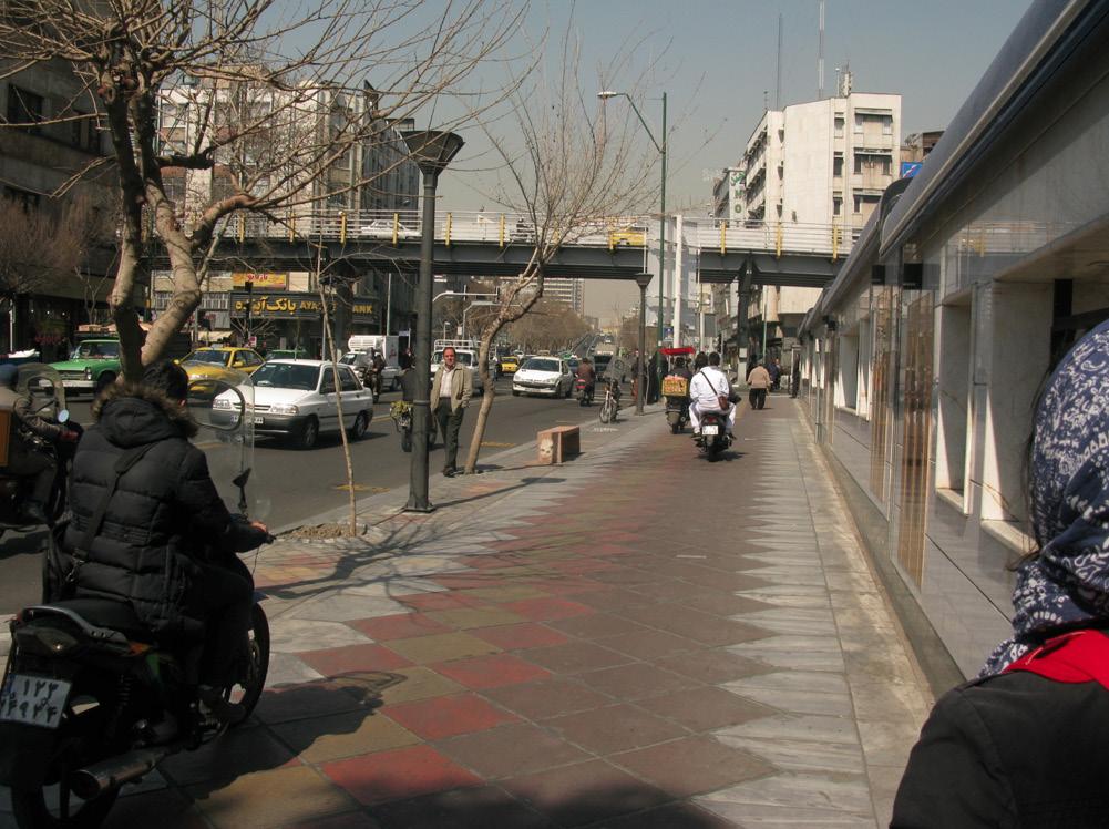
5 Analysis of Street Landscape Structure* Report: Farzaneh Alsadat Dehghan- Zeinab Hanzakian A city can be read through its streets. Stéphane Douady, Professor of Dynamics of Outof-Equilibrium Systems in Paris Diderot University began his speech with these words. He continued by explaining the significance of the street structure: When we think of a city, we first think of the houses. While they can be replaced when destroyed or abandoned, the streets remain stable. Dr. Douady s multidisciplinary team, consisting of physicists, architect, landscape architect, sociologist, urban planner and geographer aim design a plugin called (Morpheo) for GIS Software in order to define indicators for the reading of city as a complex phenomenon. Adding this plug-in can can result in understanding city changes and meaning. The main idea of this plug-in is to use topological indices (indices that do not change with changing geometry, other than cutting off) in order to analyze Simplified map on the basis of streets. Stephen Douady in the workshop of process of urban landscape relying on his visit to Tehran neighborhoods, raised questions about the evaluation of structured indices. He tried to test the accuracy of Morpheo plug-in by verifying the results of Tehran map analysis and his field observations. He explained the reasons for structures by showing different images of the street and asking about their structure and their adaptation with the analyzed plan (before the visit). Stéphane Douady in conclusion about the comparison between the analytical results of Tehran, Paris and other cities, emphasized what was obtained from the analysis of images as structure analysis was very similar to the ones analysis done by Morpheo plug-in before the visit (Pics1-6). The second part of the workshop was allocated to questions about the procedure and methods of using this software and its resulted analysis (Pic 1-6). Pic1: Shirzad Street is short and does not continue. So even though this street is significant for leading to an important street, it is slightly structured because of its short length. Building heights also shows the width of the streets should be sufficient, otherwise the dense construction would not be allowed. This information can lead to understanding of the region tissue. Pic2: Henry Corbin Street is more structured than Shirzad Street it is quickly connected to a main street, the tall buildings also indicates that. Pic3: Hafez Street is more structured than the two previous pictures. The sidewalk width and the bridge over the street affirm that. Pic4: Ferdowsi Street is more structured than previous streets, wide sidewalks and heavy traffic indicate that. Moreover, the houses that have been destroyed due to the street significance were fine buildings. Pic5: No traffic congestion is seen on Hafez Street and from the adjacent buildings and car parks; it is not hard to guess that it close to a way with organized structure. Distance index has a significant role in street analysis. Pic6: In the same way the streets can be considered as highly structured. Although this street does not have many features of the previous ones, it offers a shortcut and high 7
Neighborhood Locations and Amenities
 University of Maryland School of Architecture, Planning and Preservation Fall, 2014 Neighborhood Locations and Amenities Authors: Cole Greene Jacob Johnson Maha Tariq Under the Supervision of: Dr. Chao
Lecture 19: Common property resources
 Lecture 19: Common property resources Economics 336 Economics 336 (Toronto) Lecture 19: Common property resources 1 / 19 Introduction Common property resource: A resource for which no agent has full property
Knowledge claims in planning documents on land use and transport infrastructure impacts
 Knowledge claims in planning documents on land use and transport infrastructure impacts Presentation at the Final Workshop of the research project "Innovations for sustainable public transport in Nordic
Riocan Centre Study Area Frontenac Mall Study Area Kingston Centre Study Area
 OVERVIEW the biggest challenge of the next century (Dunham Jones, 2011). New books are continually adding methods and case studies to a growing body of literature focused on tackling this massive task.
Figure 8.2a Variation of suburban character, transit access and pedestrian accessibility by TAZ label in the study area
 Figure 8.2a Variation of suburban character, transit access and pedestrian accessibility by TAZ label in the study area Figure 8.2b Variation of suburban character, commercial residential balance and mix
Module 4 Educator s Guide Overview
 Module 4 Educator s Guide Overview Paths Module Overview This module looks at many different kinds of paths and considers why paths are where they are and how they look from space. Paths are usually not
Mapping Accessibility Over Time
 Journal of Maps, 2006, 76-87 Mapping Accessibility Over Time AHMED EL-GENEIDY and DAVID LEVINSON University of Minnesota, 500 Pillsbury Drive S.E., Minneapolis, MN 55455, USA; geneidy@umn.edu (Received
Looking at Communities: Comparing Urban and Rural Neighborhoods
 Looking at Communities: Comparing Urban and Rural Neighborhoods OVERVIEW & OBJECTIVES Our urban areas have become so dominant that frequently the children we teach have no connection with and very few
Place Syntax Tool (PST)
") Place Syntax Tool (PST) Alexander Ståhle To cite this report: Alexander Ståhle (2012) Place Syntax Tool (PST), in Angela Hull, Cecília Silva and Luca Bertolini (Eds.) Accessibility Instruments for Planning
Place Syntax Tool (PST) Alexander Ståhle To cite this report: Alexander Ståhle (2012) Place Syntax Tool (PST), in Angela Hull, Cecília Silva and Luca Bertolini (Eds.) Accessibility Instruments for Planning
Measure of Design Thinking-based Regional Innovation: Focusing on Gamcheon Culture Village
 , pp.125-129 http://dx.doi.org/10.14257/astl.2017.143.26 Measure of Design Thinking-based Regional Innovation: Focusing on Gamcheon Culture Village Na-Rang Kim 1, Soon-Goo Hong 1*, Sang-Jin Lee 2 1 Dong-A
Your web browser (Safari 7) is out of date. For more security, comfort and the best experience on this site: Update your browser Ignore
 is out of date. For more security, comfort and the best experience on this site: Update your browser Ignore") Your web browser (Safari 7) is out of date. For more security, comfort and the best experience on this site: Update your browser Ignore urban area For the complete encyclopedic entry with media resources,
Your web browser (Safari 7) is out of date. For more security, comfort and the best experience on this site: Update your browser Ignore urban area For the complete encyclopedic entry with media resources,
Smart Growth: Threat to the Quality of Life. Experience
 Smart Growth: Threat to the Quality of Life Presentation by Wendell Cox Wendell Cox Consultancy Visiting Professor Conservatoire National des Arts et Metiers Paris Frontier Centre for Public Policy Winnipeg
APPENDIX I: Traffic Forecasting Model and Assumptions
 APPENDIX I: Traffic Forecasting Model and Assumptions Appendix I reports on the assumptions and traffic model specifications that were developed to support the Reaffirmation of the 2040 Long Range Plan.
Area Classification of Surrounding Parking Facility Based on Land Use Functionality
 Open Journal of Applied Sciences, 0,, 80-85 Published Online July 0 in SciRes. http://www.scirp.org/journal/ojapps http://dx.doi.org/0.4/ojapps.0.709 Area Classification of Surrounding Parking Facility
Notes: We all know that Toulmins Spring Branch is a sub-watershed of Three Mile Creek watershed. Some part of it is in Mobile area and rest of it is
 1 Notes: This presentation is about some of our findings from a study carried out over the last 3-4 months on stormwater management of Toulmins Spring Branch watershed by NEP. The objective of this study
[Leveraging & Improving Neighborhood Connections] Area E Cedar Creek
![[Leveraging & Improving Neighborhood Connections] Area E Cedar Creek](/thumbs/86/93508963.jpg "[Leveraging & Improving Neighborhood Connections] Area E Cedar Creek") Community Charrette LINC Dallas [Leveraging & Improving Neighborhood Connections] Area E Cedar Creek 06.02.12 LINC Workshop Area E Area E has the unique distinction of at-grade frontage to the Trinity
Community Charrette LINC Dallas [Leveraging & Improving Neighborhood Connections] Area E Cedar Creek 06.02.12 LINC Workshop Area E Area E has the unique distinction of at-grade frontage to the Trinity
Unit 1, Lesson 3 What Tools and Technologies Do Geographers Use?
 Unit 1, Lesson 3 What Tools and Technologies Do Geographers Use? Geographers use a variety of tools and technologies in investigating geographic questions. Maps and globes both represent the earth, but
Urban Form and Travel Behavior:
 Urban Form and Travel Behavior: Experience from a Nordic Context! Presentation at the World Symposium on Transport and Land Use Research (WSTLUR), July 28, 2011 in Whistler, Canada! Petter Næss! Professor
Unit 1, Lesson 2. What is geographic inquiry?
 What is geographic inquiry? Unit 1, Lesson 2 Understanding the way in which social scientists investigate problems will help you conduct your own investigations about problems or issues facing your community
Urban Planning Word Search Level 1
 Urban Planning Word Search Level 1 B C P U E C O S Y S T E M P A R E U O E U R B A N P L A N N E R T N S T D H E C O U N T Y G E R E R D W R E N I C I T Y C O U N C I L A A A S U G G C I L A G P R I R
INVESTIGATION SUMMARY REPORT. McNEILL STREET WATER PLANT 142 NORTH COMMON ST SHREVEPORT, LA. OCTOBER 8 th, 2017
 INVESTIGATION SUMMARY REPORT McNEILL STREET WATER PLANT 142 NORTH COMMON ST SHREVEPORT, LA. OCTOBER 8 th, 2017 BESS MAXWELL CASE MANAGER LOUISIANA SPIRITS NORTH TEAM NOTE: THE CLIENTS IN THIS INVESTIGATION
Shaping Your Neighbourhood
 Shaping Your Neighbourhood Building a Core Sustainable Neighbourhood Action Plan Nov. 25 & 26, 2006 Welcome! Peter Russell Planner, Holland Barrs Planning Group Inc. Role in this project: Work with the
Subject: Note on spatial issues in Urban South Africa From: Alain Bertaud Date: Oct 7, A. Spatial issues
 Page 1 of 6 Subject: Note on spatial issues in Urban South Africa From: Alain Bertaud Date: Oct 7, 2009 A. Spatial issues 1. Spatial issues and the South African economy Spatial concentration of economic
Travel Time Calculation With GIS in Rail Station Location Optimization
 Travel Time Calculation With GIS in Rail Station Location Optimization Topic Scope: Transit II: Bus and Rail Stop Information and Analysis Paper: # UC8 by Sutapa Samanta Doctoral Student Department of
"GIS-Sofia" Ltd. geospatial data integration in SOFCAR geographic information system and providing services March 2018, Sofia
 "GIS-Sofia" Ltd. geospatial data integration in SOFCAR geographic information system and providing services Geographical Information System Sofia " Ltd....the beginning... Established in 1999, as a Sofia
c. What is the most distinctive above ground result of high land costs and intensive land use? i. Describe the vertical geography of a skyscraper?
 AP Human Geography Unit 7b Guided Reading: Urban Patterns and Social Issues Mr. Stepek Key Issue #1: Why Do Services Cluster Downtown? (Rubenstein p 404 410) 1. What is the CBD? What does it contain and
USER PARTICIPATION IN HOUSING REGENERATION PROJECTS
 USER PARTICIPATION IN HOUSING REGENERATION PROJECTS Dr. Hatice Sadıkoğlu Bahçeşehir University, Faculty of Architecture and Design Prof. Dr. Ahsen Özsoy Istanbul Technical University, Faculty of Architecture
Regional Snapshot Series: Transportation and Transit. Commuting and Places of Work in the Fraser Valley Regional District
 Regional Snapshot Series: Transportation and Transit Commuting and Places of Work in the Fraser Valley Regional District TABLE OF CONTENTS Complete Communities Daily Trips Live/Work Ratio Commuting Local
A Framework for the Study of Urban Health. Abdullah Baqui, DrPH, MPH, MBBS Johns Hopkins University
 This work is licensed under a Creative Commons Attribution-NonCommercial-ShareAlike License. Your use of this material constitutes acceptance of that license and the conditions of use of materials on this
transportation research in policy making for addressing mobility problems, infrastructure and functionality issues in urban areas. This study explored
 ABSTRACT: Demand supply system are the three core clusters of transportation research in policy making for addressing mobility problems, infrastructure and functionality issues in urban areas. This study
Space Syntax: Architecture and Cities MRes This programme information sheet includes details of the structure and content of the course.
 Space Syntax: Architecture and Cities MRes 2018-19 This programme information sheet includes details of the structure and content of the course. CONTENTS Overview 3 Structure 4 Content 5 Staff 6 Opportunities
Optimizing Urban Modeling based on Road Network and Land Use/Cover Changes by Using Agent Base Cellular Automata Model
 Optimizing Urban Modeling based on Road Network and Land Use/Cover Changes by Using Agent Base Cellular Automata Model Yousef Khajavigodellou 1, A. A. Alesheikh 2, Farshad Hakimpour 3, Kamra Chapi 4 1
The Built Environment, Car Ownership, and Travel Behavior in Seoul
 The Built Environment, Car Ownership, and Travel Behavior in Seoul Sang-Kyu Cho, Ph D. Candidate So-Ra Baek, Master Course Student Seoul National University Abstract Although the idea of integrating land
Letting reality speak. How the Chicago School Sociology teaches scholars to speak with our findings.
 Letting reality speak. How the Chicago School Sociology teaches scholars to speak with our findings. By Nanke Verloo n.verloo@uva.nl Assistant professor in Urban Planning, University of Amsterdam. Think
Your web browser (Safari 7) is out of date. For more security, comfort and. the best experience on this site: Update your browser Ignore
 is out of date. For more security, comfort and. the best experience on this site: Update your browser Ignore") Your web browser (Safari 7) is out of date. For more security, comfort and Activityengage the best experience on this site: Update your browser Ignore Comparing Historical Maps How can historical maps
Your web browser (Safari 7) is out of date. For more security, comfort and Activityengage the best experience on this site: Update your browser Ignore Comparing Historical Maps How can historical maps
CLAREMONT MASTER PLAN 2017: LAND USE COMMUNITY INPUT
 Planning and Development Department 14 North Street Claremont, New Hampshire 03743 Ph: (603) 542-7008 Fax: (603) 542-7033 Email: cityplanner@claremontnh.com www.claremontnh.com CLAREMONT MASTER PLAN 2017:
Data driven approaches to Urban Planning Experience from Derry/Londonderry
 Data driven approaches to Urban Planning Experience from Derry/Londonderry Anna Rose RTPI Belfast 11 th of September 1 June 26 07:47AM 2 The value of the City The space of the city is a theatre: playing
GOVERNMENT MAPPING WORKSHOP RECOVER Edmonton s Urban Wellness Plan Mapping Workshop December 4, 2017
 GOVERNMENT MAPPING WORKSHOP 12.4.17 RECOVER Edmonton s Urban Wellness Plan Mapping Workshop December 4, 2017 In July of 2017, City Council directed administration to develop RECOVER, Edmonton s Urban Wellness
Spatiotemporal Analysis of Urban Traffic Accidents: A Case Study of Tehran City, Iran
 Spatiotemporal Analysis of Urban Traffic Accidents: A Case Study of Tehran City, Iran January 2018 Niloofar HAJI MIRZA AGHASI Spatiotemporal Analysis of Urban Traffic Accidents: A Case Study of Tehran
Outline. 15. Descriptive Summary, Design, and Inference. Descriptive summaries. Data mining. The centroid
 Outline 15. Descriptive Summary, Design, and Inference Geographic Information Systems and Science SECOND EDITION Paul A. Longley, Michael F. Goodchild, David J. Maguire, David W. Rhind 2005 John Wiley
GIS Analysis of Crenshaw/LAX Line
 PDD 631 Geographic Information Systems for Public Policy, Planning & Development GIS Analysis of Crenshaw/LAX Line Biying Zhao 6679361256 Professor Barry Waite and Bonnie Shrewsbury May 12 th, 2015 Introduction
Geography and Usability of the American Community Survey. Seth Spielman Assistant Professor of Geography University of Colorado
 Geography and Usability of the American Community Survey Seth Spielman Assistant Professor of Geography University of Colorado Goals 1. To convince you that the margins of error from the American Community
The Use of Geographical Information Systems. in Historic and Cultural Places. Case Study: Town of Side. Omur ESEN
 The Use of Geographical Information Systems in Historic and Cultural Places Case Study: Town of Side Omur ESEN Selcuk University, Office of Construction and Infrastructure Dept. Konya,TURKEY omuresen@hotmail.com
MONTSERRAT PALLARES-BARBERA March 17, 2011 at 7,30 pm.
 Center for Geographic Analysis Institute for Quantitative Social Sciences Real Colegio Complutense Real Colegio Complutense. Urbanism, Quality of Life and Social Wellbeing. Schools and Services in CERDÀ'S
Problems In Large Cities
 Chapter 11 Problems In Large Cities Create a list of at least 10 problems that exist in large cities. Consider problems that you have read about in this and other chapters and/or experienced yourself.
5 Themes of Geography Review Video Notes What is Geography?
 Name PG # 5 Themes of Geography Review Video Notes What is Geography? The study of, their, and their Main Idea or Topic Continents Notes about Main Idea or Topic There are 7 Continents or in the world:
GIS for the Non-Expert
 GIS for the Non-Expert Ann Forsyth University of Minnesota February 2006 GIS for the Non-Expert 1. Definitions and problems 2. Measures being tested in Twin Cities Walking Study Basic approach, data, variables
NATHAN HALE HIGH SCHOOL PARKING AND TRAFFIC ANALYSIS. Table of Contents
 Parking and Traffic Analysis Seattle, WA Prepared for: URS Corporation 1501 4th Avenue, Suite 1400 Seattle, WA 98101-1616 Prepared by: Mirai Transportation Planning & Engineering 11410 NE 122nd Way, Suite
Too Close for Comfort
 Too Close for Comfort Overview South Carolina consists of urban, suburban, and rural communities. Students will utilize maps to label and describe the different land use classifications. Connection to
Spatial Organization of Data and Data Extraction from Maptitude
 Spatial Organization of Data and Data Extraction from Maptitude N. P. Taliceo Geospatial Information Sciences The University of Texas at Dallas UT Dallas GIS Workshop Richardson, TX March 30 31, 2018 1/
Chapter 12. Services
 Chapter 12 Services Where di services originate? Key Issue #1 Shoppers in Salzburg, Austria Origins & Types of Services Types of services Consumer services Business services Public services Changes in
ANALYSIS OF DIFFERENT URBAN FORMS IN ISTANBUL. Burçin Yazgı Urban Planning Department, Istanbul Technical University, Turkey
 ANALYSIS OF DIFFERENT URBAN FORMS IN ISTANBUL Burçin Yazgı Urban Planning Department, Istanbul Technical University, Turkey yazgi@itu.edu.tr Vedia Dökmeci Urban Planning Department, Istanbul Technical
GIS in Community & Regional Planning
 GIS in Community & Regional Planning The The role role of of GIS GIS in in Re-writing the the Zoning Bylaw for for the the City City of of Vernon LandInfo Technologies Presentation Overview The GIS Initiative
A Paradox on Traffic Networks
 A Paradox on Traffic Networks Dietrich Braess Bochum Historical remarks. The detection of the paradox is also counterintuitive Is the mathematical paradox consistent with the psychological behavior of
Housing Opportunity Sites Analysis in Western SoMa
 Housing Opportunity Sites Analysis in Western SoMa Annie Dods Marshall Snow Adrian Torres Dolly Sithounnolat Photo by: Dolly, 4/12/07 Contents Introduction Project Description Methodology Examples Photo
Introduction and Project Overview
 Greater New Orleans Regional Land Use Modeling GIS Techniques in a P olitical C ontext Louisiana Remote Sensing and GIS Workshop Wednesday, April 24, 2013 Working Towards a Shared Regional Vision Introduction
Chapter 1 Introduction
 1 Chapter 1 Introduction Figure 1.1: Westlake Plaza A warm sunny day on a downtown street and plaza, pedestrians pass on the sidewalks, people sit on benches and steps, enjoying a cup of coffee, shoppers
The maps in this resource can be freely modified and reproduced in the classroom only.
 Teacher's Notes In this activity, students work collaboratively to explore sections of old and new maps. By closely examining these documents, students learn to see maps as more than just tools for locating
Dynamic Visualization of Urban Sprawl Scenarios
 Dynamic Visualization of Urban Sprawl Scenarios Bernd STREICH Abstract Environment and landscape are threatened by urban sprawl. In the United States of America as well as in Germany we can observe that
A STRUCTURAL ANALYSIS OF THE STREETS NETWORK TO URBAN FABRIC CHARACTERIZATION
 CO-165 A STRUCTURAL ANALYSIS OF THE STREETS NETWORK TO URBAN FABRIC CHARACTERIZATION HAMAINA R., LEDUC T., MOREAU G. Centre d'études et recherches méthodologiques d'architecture, NANTES, FRANCE ABSTRACT
CADASTRAL DELIMITATION OF ADMINISTRATIVE TERRITORY IN ROMANIA IN ORDER TO ACHIEVE GENERAL URBAN PLANS
 CADASTRAL DELIMITATION OF ADMINISTRATIVE TERRITORY IN ROMANIA IN ORDER TO ACHIEVE GENERAL URBAN PLANS Lecturer PhD. eng. MAGDOLNA EVA KONCSAG, 1 Decembrie 1918 University of Alba Iulia, Romania ABSTRACT.
ARCHITECTURAL SPACE AS A NETWORK
 ARCHITECTURAL SPACE AS A NETWORK PHYSICAL AND VIRTUAL COMMUNITIES Dr Kerstin Sailer Bartlett School of Graduate Studies, University College London Lorentz Workshop Innovation at the Verge Computational
CRP 608 Winter 10 Class presentation February 04, Senior Research Associate Kirwan Institute for the Study of Race and Ethnicity
 CRP 608 Winter 10 Class presentation February 04, 2010 SAMIR GAMBHIR SAMIR GAMBHIR Senior Research Associate Kirwan Institute for the Study of Race and Ethnicity Background Kirwan Institute Our work Using
Contemporary Human Geography 3 rd Edition
 Contemporary Human Geography 3 rd Edition Chapter 13: Urban Patterns Marc Healy Elgin Community College Services are attracted to the Central Business District (CBD) because of A. accessibility. B. rivers.
Content Area: Social Studies Standard: 1. History Prepared Graduates: Develop an understanding of how people view, construct, and interpret history
 Standard: 1. History Develop an understanding of how people view, construct, and interpret history 1. Organize and sequence events to understand the concepts of chronology and cause and effect in the history
GIS-BASED VISUALISATION OF TRAFFIC NOISE
 Proceedings of the 9 th International Conference on Environmental Science and Technology Rhodes island, Greece, 1 3 September 2005 GIS-BASED VISUALISATION OF TRAFFIC NOISE A. KONSTANTINIDIS 1, K. EVANGELIDIS
Changes in Land Use, Socioeconomic Indices, and the Transportation System in Gifu City and their Relevance during the Late 20th Century
 Open Journal of Civil Engineering, 2012, 2, 183-192 http://dx.doi.org/10.4236/ojce.2012.23024 Published Online September 2012 (http://www.scirp.org/journal/ojce) Changes in Land Use, Socioeconomic Indices,
Note on Transportation and Urban Spatial Structure
 Note on Transportation and Urban Spatial Structure 1 By Alain Bertaud, Washington, ABCDE conference, April 2002 Email: duatreb@msn.com Web site: http://alain-bertaud.com/ http://alainbertaud.com/ The physical
How Geography Affects Consumer Behaviour The automobile example
 How Geography Affects Consumer Behaviour The automobile example Murtaza Haider, PhD Chuck Chakrapani, Ph.D. We all know that where a consumer lives influences his or her consumption patterns and behaviours.
Aerial Photography and Imagery Resources Guide
 Aerial Photography and Imagery Resources Guide Cheyenne and Laramie County Cooperative GIS Created and Maintained by the GIS Coordinator for the Cooperative GIS Program March 2011 CHEYENNE / LARAMIE COUNTY
Factors Affecting Human Settlement
 Factors Affecting Human Settlement Physical Factors One of the most basic factors affecting settlement patterns is the physical geography of the land. Climate is key, because if a place is too dry, too
ALTER ECO Alternative tourist strategies to enhance the local sustainable development of tourism by promoting Mediterranean identity Module 2: Testing
 ALTER ECO Alternative tourist strategies to enhance the local sustainable development of tourism by promoting Mediterranean identity Module 2: Testing WHY? Areas of high tourism attraction in coastal cities
Geography Skills Progression Key Stage 2
 Year 3 Year 4 Year 5 Year 6 Expectations at end of key stage Location knowledge the countries of Europe? countries in Europe, environmental regions? countries in Europe, key physical and human characteristics?
Curriculum Unit. Instructional Unit #1
 Curriculum Unit Name of Course: AP Human Geography Grade Level(s): 9-12 Brief Description (Course Catalog): The purpose of the AP Human Geography course is to introduce students to the systematic study
Introduction to Human Geography & Geographic Concepts
 Introduction to Human Geography & Geographic Concepts What is Geography? Literal definition: Description of the Earth Serves as a bridge between physical and human sciences the study of the earth and its
Aerial Photography and Imagery Resources Guide
 Aerial Photography and Imagery Resources Guide Cheyenne and Laramie County Cooperative GIS Created and Maintained by the GIS Coordinator for the Cooperative GIS Program May 2016 CHEYENNE / LARAMIE COUNTY
Relationship between Spatial Configuration and Ferry, Bus and Railway Patronage in Brisbane CBD
 Relationship between Spatial Configuration and Ferry, Bus and Railway Patronage in Brisbane CBD Sima Vaez 1, Matthew Burke 2,Tooran Alizadeh 3 Email for correspondence: sima.vaezeslami@griffithuni.edu.au
BROOKINGS May
 Appendix 1. Technical Methodology This study combines detailed data on transit systems, demographics, and employment to determine the accessibility of jobs via transit within and across the country s 100
The 3V Approach. Transforming the Urban Space through Transit Oriented Development. Gerald Ollivier Transport Cluster Leader World Bank Hub Singapore
 Transforming the Urban Space through Transit Oriented Development The 3V Approach Gerald Ollivier Transport Cluster Leader World Bank Hub Singapore MDTF on Sustainable Urbanization The China-World Bank
Employment Decentralization and Commuting in U.S. Metropolitan Areas. Symposium on the Work of Leon Moses
 Employment Decentralization and Commuting in U.S. Metropolitan Areas Alex Anas Professor of Economics University at Buffalo Symposium on the Work of Leon Moses February 7, 2014 9:30-11:15am, and 2:30-4:30pm
Developed new methodologies for mapping and characterizing suburban sprawl in the Northeastern Forests
 Development of Functional Ecological Indicators of Suburban Sprawl for the Northeastern Forest Landscape Principal Investigator: Austin Troy UVM, Rubenstein School of Environment and Natural Resources
Rural Pennsylvania: Where Is It Anyway? A Compendium of the Definitions of Rural and Rationale for Their Use
 Rural Pennsylvania: Where Is It Anyway? A Compendium of the Definitions of Rural and Rationale for Their Use Pennsylvania Office of Rural Health 310 Nursing Sciences Building University Park, PA 16802
Traffic Demand Forecast
 Chapter 5 Traffic Demand Forecast One of the important objectives of traffic demand forecast in a transportation master plan study is to examine the concepts and policies in proposed plans by numerically
from
 8Map Generalization and Classification Our human and natural environments are complex and full of detail. Maps work by strategically reducing detail and grouping phenomena together. Driven by your intent,
Discerning sprawl factors of Shiraz city and how to make it livable
 Discerning sprawl factors of Shiraz city and how to make it livable 1. Introduction: Iran territory has now been directly affected by urban land-uses which are shaping landscapes in cities and around them.
3.0 ANALYSIS OF FUTURE TRANSPORTATION NEEDS
 3.0 ANALYSIS OF FUTURE TRANSPORTATION NEEDS In order to better determine future roadway expansion and connectivity needs, future population growth and land development patterns were analyzed as part of
Interregional Cooperation in the Apennines
 INTERNATIONAL WORKSHOP THE ALPS AND THE ARDENNES: SHARING EXPERIENCES AMONG TRANSBOUNDARY MOUNTAIN AREAS Interregional Cooperation in the Apennines Massimo Sargolini, professor at the University of Camerino,
SPATIAL EVALUATION OF URBAN FORM WITH RESPECT TO BUILDING DENSITY IN ÝSTANBUL
 SPATIAL EVALUATION OF URBAN FORM WITH RESPECT TO BUILDING DENSITY IN ÝSTANBUL Burçin Yazgý*, Vedia Dökmeci* *Urban Planning Department, Ýstanbul Technical University, Turkey byazgi@gmail.com, dokmeciv@itu.edu.tr
Changes in Land Use, Transportation System and the Mobility in Gifu by using Historical Map, Statistics and Personal Trip Survey Data
 Changes in Land Use, Transportation System and the Mobility in Gifu by using Historical Map, Statistics and Personal Trip Survey Data Min GUO 1, Fumitaka KURAUCHI 2 1 DC, Graduate School of Eng., Gifu
TUESDAYS AT APA PLANNING AND HEALTH. SAGAR SHAH, PhD AMERICAN PLANNING ASSOCIATION SEPTEMBER 2017 DISCUSSING THE ROLE OF FACTORS INFLUENCING HEALTH
 SAGAR SHAH, PhD sshah@planning.org AMERICAN PLANNING ASSOCIATION SEPTEMBER 2017 TUESDAYS AT APA PLANNING AND HEALTH DISCUSSING THE ROLE OF FACTORS INFLUENCING HEALTH Outline of the Presentation PLANNING
Susan Clark NRS 509 Nov. 29, 2005
 Susan Clark NRS 509 Nov. 29, 2005 The original intent of this project was to look at the role of GIS in the inventory of bicycle and pedestrian facilities. The research, however, indicates a different
Trip Distribution Analysis of Vadodara City
 GRD Journals Global Research and Development Journal for Engineering Recent Advances in Civil Engineering for Global Sustainability March 2016 e-issn: 2455-5703 Trip Distribution Analysis of Vadodara City
Measuring connectivity in London
 Measuring connectivity in London OECD, Paris 30 th October 2017 Simon Cooper TfL City Planning 1 Overview TfL Connectivity measures in TfL PTALs Travel time mapping Catchment analysis WebCAT Current and
Experiential Learning Module: Is it GREEN in our Backyard? (or Space in the City ) 1
 1") Experiential Learning Module: Is it GREEN in our Backyard? (or Space in the City ) 1 BIG QUESTION How do human activities impact the environment and how can we respond to it? OVERVIEW Understanding land
Experiential Learning Module: Is it GREEN in our Backyard? (or Space in the City ) 1 BIG QUESTION How do human activities impact the environment and how can we respond to it? OVERVIEW Understanding land
Modeling Susceptible Districts in GIS for Managing the Repair and Maintenance of Ancient Monuments
 Available online at www.pelagiaresearchlibrary.com European Journal of Experimental Biology, 2012, 2 (5):1708-1713 ISSN: 2248 9215 CODEN (USA): EJEBAU Modeling Susceptible Districts in GIS for Managing
Bishkek City Development Agency. Urban Planning Bishkek
 Bishkek City Development Agency Urban Planning Bishkek Bishkek City Development Agency Official name City budget Population Area GRP Import value Export value External trade turnover Foreign direct investments
III. FORECASTED GROWTH
 III. FORECASTED GROWTH In order to properly identify potential improvement projects that will be required for the transportation system in Milliken, it is important to first understand the nature and volume
Spatial profile of three South African cities
 Spatial Outcomes Workshop South African Reserve Bank Conference Centre Pretoria September 29-30, 2009 Spatial profile of three South African cities by Alain Bertaud September 29 Email: duatreb@msn.com
An online data and consulting resource of THE UNIVERSITY OF TOLEDO THE JACK FORD URBAN AFFAIRS CENTER
 An online data and consulting resource of THE JACK FORD URBAN AFFAIRS CENTER THE CENTER FOR GEOGRAPHIC INFORMATION SCIENCE AND APPLIED GEOGRAPHICS DEPARTMENT OF GEOGRAPHY AND PLANNING THE UNIVERSITY OF
P. O. Box 5043, 2600 CR Delft, the Netherlands, Building, Pokfulam Road, Hong Kong,
 THE THEORY OF THE NATURAL URBAN TRANSFORMATION PROCESS: THE RELATIONSHIP BETWEEN STREET NETWORK CONFIGURATION, DENSITY AND DEGREE OF FUNCTION MIXTURE OF BUILT ENVIRONMENTS Akkelies van Nes 1, Yu Ye 2 1