Modeling Susceptible Districts in GIS for Managing the Repair and Maintenance of Ancient Monuments
|
|
|
- Phyllis Wilkins
- 5 years ago
- Views:
Transcription
:1708-1713 ISSN: 2248 9215 CODEN (USA): EJEBAU Modeling Susceptible Districts in GIS for Managing the Repair and Maintenance of Ancient")

1 Available online at European Journal of Experimental Biology, 2012, 2 (5): ISSN: CODEN (USA): EJEBAU Modeling Susceptible Districts in GIS for Managing the Repair and Maintenance of Ancient Monuments Bashir Beig-Babaee 1, Naser Egbali 2 1 Malekan Branch, Islamic Azad University, Malekan, Iran 2 Tehran merkezi Branch, Islamic Azad University, Tehran, Iran ABSTARCT Iran has many significant signs of historical urbanization. These signs include historical monuments and ancient buildings. It is imperative to protect these signs, for they are always susceptible to natural disasters and human interference. Thus, there has been an increasing need for an all-embracing approach to natural disasters and their consequences. The historical city of Tabriz is considered as one of the earthquake zones of Iran due to its vicinity to active dextral faults. Meanwhile, the municipality of District 8 of Tabriz, which is known as the historical and cultural municipality in Tabriz, has priceless historical places, a rusty fabric, and heavy traffic and the historical buildings of the city are always threatened by natural and unnatural disasters. In the present research, weighted index overlay analysis (WIOA) was used in GIS to distinguish the susceptible areas of the region. The layers used in this model include distance from the fault, the quality of the structures, vicinity to roads, vicinity to open spaces, fire station, gas station, and the topography of the studied region. The results showed that only 13.94% of the studied region is in a favorable or very favorable condition in terms of susceptibility during crisis % of the region is in an average condition. Finally, 38.69% of the region is in unfavorable or very unfavorable condition in this regard. This necessitates precise, systematic planning before, during, and after crisis for protection, repair, and maintenance of the ancient monuments of the region. Keywords: historical monuments, Bazaar of Tabriz, District 8, WIOA INTRODUCTION Our historical cities are disappearing and during the past two decades there has been an increasing formation of vast, modern urban fabric around the historical fabric. The excessive expansion of cities, natural disasters, and unscientific human interferences (e.g. roads, passages, and bridges that run through historical structures) has led to irreversible damages to the historical fabric [1]. Due to the unpredictable nature of most natural disasters and the necessity to make quick decisions and take prompt action, a new branch of knowledge has emerged which is known as management and maintenance of historical monuments. Tabriz City, with its dense population and priceless historic structures, is always threated by these hazards. Under these conditions, any natural or unnatural crisis will cause irremediable damages and obviously correct management is the only way to prevent such events [2,3]. Region 8 of Tabriz is of utmost importance due to its historical fabric and its dense population. Natural disasters and lack of proper management has caused much destruction in the historical monuments of the region. It is thus imperative to distinguish different areas of the district in terms of their susceptibility [4]. This district is located at the center of the city and attracts a large population on a daily basis. Hence, there is always much traffic in the streets and thoroughfares that puts much pressure on the historical fabric of the district. Due to the rusty fabric and dense population, any crisis in the district will clearly lead to considerable casualties and historical damage. Thus, an 1708
2 attempt was made in the present research to distinguish the susceptible areas of District 8 of Tabriz using GIS [5]. Pourmohammadi et al. (2006) carried out a research on the role and application of GIS in controlling and rescuing the urban and rural residents of Tabriz. They studied the role of GIS in crisis management and rescue process before, during, and after crisis in Tabriz [6]. Asgari and Parhizcar (2006) studied the strategies for dealing with earthquakes and reducing the resulting damages in District 17 of Tehran. They introduced GIS as a helpful tool for crisis management by urban planners [7]. Adhami and Maleki (2009) examined the role of GIS in crisis prevention and management. They believe that GIS data and efficiently trained personnel can increase the efficiency of crisis response systems [2]. Asgari and colleagues (cited in Nesyani, 2010) studied the role of urban services in managing crises and accidents with an approach to GIS. Nesyani (2010) also applied SDSS in GIS for crisis management to analyze District 8 of Tabriz in terms of its susceptibility to earthquakes [8]. The Studied Region Tabriz is one of the historical cities of Iran with an area of 140 km 2 located at N E. The mean altitude is about 1340 meters. The historical, geographical, cultural, economic position of Tabriz has given it a special place in the country. Meanwhile, District 8 of Tabriz, with an area of 260 hectares, constitutes the major rustic and historical fabric of the city. Susceptibility of Tabriz to natural disasters The Iranian plateau is a disaster-prone area and Tabriz City is highly susceptible to natural disasters due to its geographical structure and its special topography. Earthquake and flood are the major natural disasters that have accompanied this ancient city throughout history, imposing much casualties and costs on the region. The historical and ancient monuments of the city have suffered the greatest damage from such destructive earthquakes. The natural disasters that threaten the historical monuments of cities 1. Flood According to hydrological and meteorological studies of Tabriz, February, March, and April are the rainiest months of the year (ZISTA Architecture & Urban Planning Consulting, 1999). Table 1 The flood-based disasters in Tabriz in a five-year period City Region Date Damage (million rial) Central part Villages of the central part Tabriz Villages of the central part Entire city Subsidiary parts Source: ZISTA (1999) 2. Earthquake Tabriz is one of the earthquake-prone regions of the country, such that earthquakes have destroyed the city several times throughout history and have caused many casualties and many costs. One of the most destructive of earthquakes occurred in 1721 BC in Tabriz where 250 thousand people were killed (Table 2). Considering the multimillion population of Tabriz, any earthquake can cause dreadful casualties. Table 2 Destructive earthquakes in Tabriz Year Severity of destruction Casualties 858 BC Destruction of the entire city BC Severe earthquake BC Severe earthquake BC Severe earthquake BC Very severe earthquake BC Severe earthquake BC Severe earthquake Source: Shafi i (2005) The historical value of the region There are many historical monuments that have survived from different period and are scattered around the region, including Bazaar of Tabriz, Arg (castle) of Tabriz, Congregational Mosque of Tabriz, Saheb-ol-Amr Mosque, Blue Mosque, Maqbaratoshoara, Tabriz Museum, etc. 1709

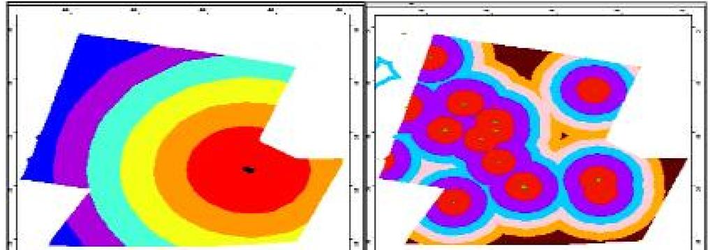
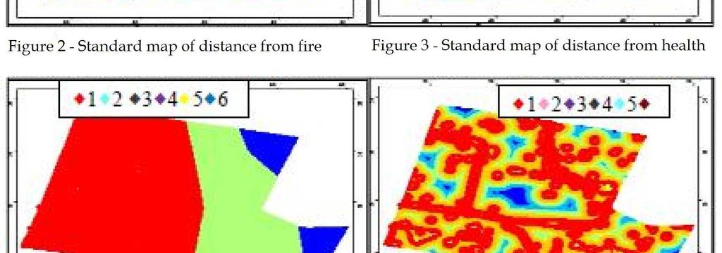
3 MATERIALS AND METHODS In the present research, library studies were carried out to identify the driving factors in locating the regions susceptible to natural disasters. The collected parameters are as follows: Distance from dangerous areas such as gas stations, power lines such as water and gas, etc. Distance from roads and thoroughfares (minor arterial roads and local roads) Access to open spaces (the more the access, the less the susceptibility) Topography (slopes are positively associated with susceptibility) Distance from faults (negatively associated with susceptibility) Quality of the structures Distance from fire stations Creating the information layers Considering the mentioned parameters, there was a need for a land use map for the management of the historical fabric and reduction of damages at the time of disasters. Thus, the land use map of Tabriz was acquired from the Department of Housing and Urban Development. Then, different areas designated for specific purposes of land use were marked out and used for extracting the required layers (figure 2). It must be noted that a map related to the faults as well as the topography of the region were also obtained from the Department of Natural Resources. Figure 1 The land use map of Region 8 of Tabriz Standardization of the information layers The first step in managing the maintenance of historical monuments at the time of crisis is to extract the required information layers. Most of the layers of the required criteria and sub-criteria for identification of susceptible regions are separated and valuated by creating a buffer or, in some cases, by means of Query Builder. The different layers are drawn on the surface of the studied region and are stored in the database in the form of raster layers (which are able to reclassify). The layers are prioritized and standardized into 3 to 6 categories based on the created buffer or the existing applications and the final layers are as follows: 1710

4 1711
: [9].")

5 RESULTS Weighted index overlay analysis Spatial analysis is done to identify the potential regions that are extracted from the values of each pixel of the raster map based on some criteria. The weighted index overlay model enables us to combine different maps. In the present research the multi-criteria method is used and the model is defined as (Murray, 2003): [9]. S n = i S ij W W i i where is the score assigned to each cell, is the weight of the ith information layer, and is the score of the jth class from the ith map. In this model, each class of different layers can be assigned a particular weight and considering the importance of each layer compared to other layers, we can assign a weight to each layer based on its importance. This is one of the characteristics of this model in combining layers [10, 11]. To obtain the output map for the susceptible areas of Region 8 of Tabriz, the maps were classified and the potential of each of the parameters was evaluated by the authors (table 4). Table 3 The weights of the evaluated criteria in the index overlay method Localization Criteria Priority Importance Distance from faults 19% Quality of structures 20% Vicinity to roads 18% Vicinity to open spaces 11% Distance from fire station 12% Distance from gas station 8% Altitude 12% After standardization, the layers were imported in Weighted Overly environment in ARC GIS 9/2. After modeling (figure 8). Figure 8 The final map obtained from WIOA 1712
6 DISCUSSION AND CONCLUSION Protection of historical monuments against natural disasters has received increasing attention over the last few decades. Especially after recent earthquakes and other devastating natural disasters that led to destruction of priceless historical monuments around the world, this issue has turned into a recognized and common issue. In countries where managers of service organizations had no idea of managing the maintenance of historical monuments for prevention, readiness, and confrontation plans, coordination between different sectors, public training, etc., we have witnessed an increasing awareness among the people of the society in this regard. Now the responsibility of preparing the society falls on the shoulders of administrators, planners, and experts. Tabriz is susceptible to various hazards due to its special geographical and climatic condition and its natural structure and most of the known natural disasters of the world have occurred in this city. Considering the history of the city with its hundreds of priceless historical monuments, there is a greater chance of damage and costs due to hazards. Thus, the bitter experiences of the past on the one hand and the necessity for a prompt response to different disasters that threaten the historical fabric of the city on the other hand entails creating a system for confronting these destructive crises. One of the most critical regions of Tabriz, i.e. Region 8, was studied in the present research. The factors that distinguish this region from others are as follows: the ancient monuments that has survived different historical periods are scattered around the city, including Bazaar of Tabriz, Arg (castle) of Tabriz, Congregational Mosque of Tabriz, Saheb-ol-Amr Mosque, Blue Mosque, Maqbaratoshoara, Tabriz Museum, etc. Another important characteristic of the region is the presence of old residential areas. The disastrous record of this city necessitated the adoption of strategies for classifying the susceptible parts of the region. This would enable us to take necessary actions for preventing possible damage to the rustic and historical fabric of the city before, during, and after crisis. Thus, the susceptibility map of the region was created using weighted index overlay method (figure 8). The results of the output of the model indicate that only 13.94% of the studied region is in a favorable or very favorable condition % of the area is in an average condition in terms of susceptibility during crises % of the area is in an unfavorable or very unfavorable condition. Considering the studies carried out and the results related to the layer of fire station, it must be noted that the radius of action of the closest station is between meters, we have an area in the northwest of the region that is not covered by the firefighting services. It is thus recommended that another fire station be established in that area. It is also recommended that the instable non-historical regions be converted to open spaces to reduce the pressure on the historical fabric and enable its repair and maintenance. In general, since a large part of Region 8 of Tabriz lies within the average to very unfavorable spectrum, it is necessary for the officials to implement the best strategy for protection of the historical monuments of the region and conversion of the old, non-historical areas to open spaces as specified by the overlay map (figure 8) and thus reduce the destructive physical pressures caused by traffic. The recommended strategies and others can prevent the destruction of the historical fabric and the rustic residential areas of the region and therefore maintain the historical identity of the city. REFERENCES [1] M Ahadnejad, National Congress on Rustic Urban Fabrics, 2009, pp 221. [2] T Ahmadi, A study of the historical fabric, 2008, pp [3] S Adhami, J Maleki, GIS and its application in prevention and management of crisis, 2009, pp [4] B Beig-Babaee, Urban GIS and electronic citizens, 2007, pp [5] B Beig-Babaee, Doctorate Dissertation, IAU, 2011, pp 48. [6] M.R Pourmohammadi, The role and application of GIS in management, 2006, pp [7] A Asgari, A Parhizcar, Application of urban planning methods for reduction of susceptibility to earthquake damages using GIS, 2008, pp [8] B Nesyani, Crisis management in case of earthquakes in urban areas before it occurs, 2010, pp 65. [9] J Murray, A.T Ogden, P.M McDaniel, Soil Sci. 2003, 168(11): [10] S Tudes, N.D Yigiter, Preparation of land use planning model using GIS based on AHP, 2009, [11] J.J Kao, Y Lin, Multifactor spatial analysis for landfill siting,1997, 122(10):
Evaluating Earthquake Disaster Management in the Worn Urban Texture (Case Study: Farameh Neighbourhood, Damavand City)
") ORIGINAL ARTICLE Received 12 Oct. 2013 Accepted 03 Jan. 2014 Copyright 2014 Scienceline Publication Journal of Civil Engineering and Urbanism Volume 4, Issue 1: 4146 (2014) ISSN22520430 Evaluating Earthquake
ORIGINAL ARTICLE Received 12 Oct. 2013 Accepted 03 Jan. 2014 Copyright 2014 Scienceline Publication Journal of Civil Engineering and Urbanism Volume 4, Issue 1: 4146 (2014) ISSN22520430 Evaluating Earthquake
Land Use of the Geographical Information System (GIS) and Mathematical Models in Planning Urban Parks & Green Spaces
 and Mathematical Models in Planning Urban Parks & Green Spaces") Land Use of the Geographical Information System (GIS) and Mathematical Models in Planning Urban Key words: SUMMARY TS 37 Spatial Development Infrastructure Linkages with Urban Planning and Infrastructure
Land Use of the Geographical Information System (GIS) and Mathematical Models in Planning Urban Key words: SUMMARY TS 37 Spatial Development Infrastructure Linkages with Urban Planning and Infrastructure
Perception of Earthquake Risk and Postdisaster
 Perception of Earthquake Risk and Postdisaster Reconstruction: Comparative Study of Two Residential Neighborhoods on Different Socio-economic Status in Tehran Seyed Ali Badri University of Tehran, sabadri@ut.ac.ir
GENERAL. CHAPTER 1 BACKGROUND AND PURPOSE OF THE GUIDELINES Background of the Guidelines Purpose of the Guidelines...
 GENERAL CHAPTER 1 BACKGROUND AND PURPOSE OF THE GUIDELINES... 1 1.1 Background of the Guidelines... 1 1.2 Purpose of the Guidelines... 3 CHAPTER 2 APPLICATION OF THE GUIDELINES... 3 2.1 Potential Users
An Analysis of Physical Earthquake Susceptibility of Kerman Population Using GIS
 Geography and Planning No. 38 s 203 An Analysis of Physical Earthquake Susceptibility of Kerman Population Using GIS R. Valizade Earth surface temperature has been used in a wide variety of scientific
Spatiotemporal Analysis of Urban Traffic Accidents: A Case Study of Tehran City, Iran
 Spatiotemporal Analysis of Urban Traffic Accidents: A Case Study of Tehran City, Iran January 2018 Niloofar HAJI MIRZA AGHASI Spatiotemporal Analysis of Urban Traffic Accidents: A Case Study of Tehran
Discerning sprawl factors of Shiraz city and how to make it livable
 Discerning sprawl factors of Shiraz city and how to make it livable 1. Introduction: Iran territory has now been directly affected by urban land-uses which are shaping landscapes in cities and around them.
1. 1 What hazard maps have been developed in your country?
 REPUBLIC OF SLOVENIA MINISTRY OF DEFENCE ADMINISTRATION FOR CIVIL PROTECTION AND DISASTER RELIEF Kardeljeva plošcad 21, 1000 Ljubljana telephone: (+386) 1 471 33 22, fax: (+386) 1 431 81 17 ANSWERS TO
GIS Geographical Information Systems. GIS Management
 GIS Geographical Information Systems GIS Management Difficulties on establishing a GIS Funding GIS Determining Project Standards Data Gathering Map Development Recruiting GIS Professionals Educating Staff
RISK OF PRINCIPAL DISASTERS IN INDIA AND IMPACTS OF DISASTERS ON ECONOMIC DEVELOPMENT
 RISK OF PRINCIPAL DISASTERS IN INDIA AND IMPACTS OF DISASTERS ON ECONOMIC DEVELOPMENT At the Himachal Pradesh Institute of Public Administration Shimla 05. 05.2012 Improve Disaster Management with the
Progress Report. Flood Hazard Mapping in Thailand
 Progress Report Flood Hazard Mapping in Thailand Prepared By: Mr. PAITOON NAKTAE Chief of Safety Standard sub-beuro Disaster Prevention beuro Department of Disaster Prevention and Mitigation THAILAND E-mail:
THE STUDY ON 4S TECHNOLOGY IN THE COMMAND OF EARTHQUAKE DISASTER EMERGENCY 1
 THE STUDY ON 4S TECHNOLOGY IN THE COMMAND OF EARTHQUAKE DISASTER EMERGENCY 1 Zhou Wensheng 1, Huang Jianxi 2, Li Qiang 3, Liu Ze 3 1 Associate Professor, School of Architecture, Tsinghua University, Beijing.
ADVANCED PLACEMENT HUMAN GEOGRAPHY
 ADVANCED PLACEMENT HUMAN GEOGRAPHY Unit One Geography: Its Nature and Perspectives Session 3 INTERPRETATION OF PLACES AND PATTERNS PLACE: THE GEOGRAPHIC TERM Place is deceptively complex. Place describes
USING 3D GIS TO ASSESS ENVIRONMENTAL FLOOD HAZARDS IN MINA
 King Fahd University of Petroleum & Minerals College of Environmental Design Geographical Information system USING 3D GIS TO ASSESS ENVIRONMENTAL FLOOD HAZARDS IN MINA Prepared by : Ali AL-Zahrani OUTLINE
Disaster Management in Mongolia
 The Third UN-GGIM-AP Plenary Meeting Disaster Management in Mongolia ~Coordination among NGIA & Other Related Organizations and Recommendations~ Bali Indonesia 10 November 2014 Khurelshagai Ayurzana, Director
COMPREHENSIVE GIS-BASED SOLUTION FOR ROAD BLOCKAGE DUE TO SEISMIC BUILDING COLLAPSE IN TEHRAN
 COMPREHENSIVE GIS-BASED SOLUTION FOR ROAD BLOCKAGE DUE TO SEISMIC BUILDING COLLAPSE IN TEHRAN B. Mansouri 1, R. Nourjou 2 and K.A. Hosseini 3 1 Assistant Professor, Dept. of Emergency Management, International
SEISMIC RISK ASSESSMENT IN ARMENIA
 SEISMIC RISK ASSESSMENT IN ARMENIA Hovhannes Khangeldyan Head of National Crisis Management Center Rescue Service Ministry of Emergency Situations of the Republic of Armenia Tokyo, 2016 ARMENIA: GEOGRAPHICAL
REAL-TIME ASSESSMENT OF EARTHQUAKE DISASTER IN YOKOHAMA BASED ON DENSE STRONG-MOTION NETWORK
 REAL-TIME ASSESSMENT OF EARTHQUAKE DISASTER IN YOKOHAMA BASED ON DENSE STRONG-MOTION NETWORK Saburoh MIDORIKAWA 1 And Susumu ABE 2 SUMMARY This paper describes a system for REal-time Assessment of earthquake
Report. Developing a course component on disaster management
 Report Developing a course component on disaster management By Chira Prangkio Tawee Chaipimonplin Department of Geography, Faculty of Social Sciences, Chiang Mai University Thailand Presented at Indian
Assessing Hazards and Risk
 Page 1 of 6 EENS 204 Tulane University Natural Disasters Prof. Stephen A. Nelson Assessing Hazards and Risk This page last updated on 07-Jan-2004 As discussed before, natural disasters are produced by
(First Edition: prepared on 29/12/2003)
") (First Edition: prepared on 29/12/2003) Dr Sassan Eshghi 1 and Dr Mehdi Zaré 2 International Institute of Earthquake Engineering and Seismology, Tehran, P.O.Box: 19395/3913, IRAN e-mails: 1)s.eshghi@iiees.ac.ir,
(First Edition: prepared on 29/12/2003) Dr Sassan Eshghi 1 and Dr Mehdi Zaré 2 International Institute of Earthquake Engineering and Seismology, Tehran, P.O.Box: 19395/3913, IRAN e-mails: 1)s.eshghi@iiees.ac.ir,
Seismicity. Chapter 2 : Geographic Database Development 29
 Final Report Main Report 2.2.5. Seismicity (1) Earthquake Catalogue and Seismic Data Two earthquake catalogues are used in the Study, namely: Moinfar, A.A., Mahdavian, A. and Maleky, E. (1994): Historical
Pacific Catastrophe Risk Assessment And Financing Initiative
 Pacific Catastrophe Risk Assessment And Financing Initiative VANUATU September 211 Country Risk Profile: VANUATU is expected to incur, on average, 48 million USD per year in losses due to earthquakes and
LAND USE PLANNING AND RISK: LESSONS FROM THREE AUSTRALIAN PORT CITIES
 LAND USE PLANNING AND RISK: LESSONS FROM THREE AUSTRALIAN PORT CITIES Ken Granger Disaster Risk Scientist Slide No. 1 Land use planning is the single most important mitigation measure for limiting future
Jordan's Strategic Research Agenda in cultural heritage
 Jordan's Strategic Research Agenda in cultural heritage Analysis of main results Alessandra Gandini Amman, Jordan 3 rd November 2013 Main objectives The work performed had the main objective of giving
Geography Education Challenges Regarding Disaster Mitigation in Japan
 Geography Education Challenges Regarding Disaster Mitigation in Japan Koji OHNISHI 1 University of Toyama, Toyama, JAPAN Hiroshi MITSUHASHI 2 Ministry of Education, Culture, Sports, Science & Technology,
Earthquakes. & Expansive Soils
 Earthquakes & Expansive Soils January 22, 2009 Plan Update Flanagan & Associates, LLC Consultants Tulsa, OK www.rdflanagan.com rdflanagan@rdflanagan.com Plan can be reviewed at: www.rdflanagan.com/.html
Flood hazard mapping in Urban Council limit, Vavuniya District, Sri Lanka- A GIS approach
 International Research Journal of Environment Sciences E-ISSN 2319 1414 Flood hazard mapping in Urban Council limit, Vavuniya District, Sri Lanka- A GIS approach Abstract M.S.R. Akther* and G. Tharani
THE 3D SIMULATION INFORMATION SYSTEM FOR ASSESSING THE FLOODING LOST IN KEELUNG RIVER BASIN
 THE 3D SIMULATION INFORMATION SYSTEM FOR ASSESSING THE FLOODING LOST IN KEELUNG RIVER BASIN Kuo-Chung Wen *, Tsung-Hsing Huang ** * Associate Professor, Chinese Culture University, Taipei **Master, Chinese
Envrionmental impact assessment of urban development plan by vulnerability model application
 International Journal of Environmental Science & Technology Vol., No., pp. 7-, Spring Environmental impact assessment Envrionmental impact assessment of urban development plan by vulnerability model application
GUIDELINES FOR CONSTRUCTION TECHNOLOGY TRANSFER DEVELOPMENT OF WARNING AND EVACUATION SYSTEM AGAINST SEDIMENT DISASTERS IN DEVELOPING COUNTRIES
 GUIDELINES FOR CONSTRUCTION TECHNOLOGY TRANSFER DEVELOPMENT OF WARNING AND EVACUATION SYSTEM AGAINST SEDIMENT DISASTERS IN DEVELOPING COUNTRIES MARCH 2004 Ministry of Land, Infrastructure and Transport
Planning Road Networks in New Cities Using GIS: The Case of New Sohag, Egypt
 Planning Road Networks in New Cities Using GIS: The Case of New Sohag, Egypt Mostafa Abdel-Bary Ebrahim, Egypt Ihab Yehya Abed-Elhafez, Kingdom of Saudi Arabia Keywords: Road network evaluation; GIS, Spatial
International Journal of Modern Trends in Engineering and Research e-issn No.: , Date: April, 2016
 International Journal of Modern Trends in Engineering and Research www.ijmter.com e-issn No.:2349-9745, Date: 28-30 April, 2016 Landslide Hazard Management Maps for Settlements in Yelwandi River Basin,
A More Comprehensive Vulnerability Assessment: Flood Damage in Virginia Beach
 A More Comprehensive Vulnerability Assessment: Flood Damage in Virginia Beach By Raj Shah GIS in Water Resources Fall 2017 Introduction One of the most obvious effects of flooding events is death. Humans
Identification of wind affected regions in Zabol district (Sistan va Baluchestan province, southeast of Iran)
") Available online at www.pelagiaresearchlibrary.com European Journal of Experimental Biology, 2013, 3(2):624630 Identification of wind affected regions in Zabol district (Sistan va Baluchestan province,
Available online at www.pelagiaresearchlibrary.com European Journal of Experimental Biology, 2013, 3(2):624630 Identification of wind affected regions in Zabol district (Sistan va Baluchestan province,
The UN-GGIM: Europe core data initiative to encourage Geographic information supporting Sustainable Development Goals Dominique Laurent, France
 INSPIRE conference Strasbourg 6 September 2017 The UN-GGIM: Europe core data initiative to encourage Geographic information supporting Sustainable Development Goals Dominique Laurent, France Introduction
MONITORING OF URBAN RECONSTRUCTION: A STUDY OF RECOVERY PROCESS IN BAM AFTER THE 2003 EARTHQUAKE
 OS13-Fri-AM-6 The 14th Japan Earthquake Engineering Symposium (2014) MONITORING OF URBAN RECONSTRUCTION: A STUDY OF RECOVERY PROCESS IN BAM AFTER THE 2003 EARTHQUAKE Seyed Omid HASHEMI PARAST 1, Fumio
Specified Issue. Pic3. Spring 2015
 Pic3 12 Pic1 11 Pic6 Pic2 10 Pic5 performance since structured streets and important buildings surround it. According to the distance index, the tissue is not too dense, while high-rise buildings are observed.
Desertification Hazard Zonation by Means of ICD Method in Kouhdasht Watershed
 DESERT DESERT Online at http://jdesert.ut.ac.ir DESERT 17 (13) 233240 Desertification Hazard Zonation by Means of ICD Method in Kouhdasht Watershed Gh. Chamanpira a*, Gh.R. Zehtabian b, H. Ahmadi c, M.
IMPERIAL COUNTY PLANNING AND DEVELOPMENT
 IMPERIAL COUNTY PLANNING AND DEVELOPMENT GEODATABASE USER MANUAL FOR COUNTY BUSINESS DEVELOPMENT GIS June 2010 Prepared for: Prepared by: County of Imperial Planning and Development 801 Main Street El
Comparative Survey of Open Spaces Between District One and District Two in Zanjan City Temporary Accomodation of Wounded People After Earthquake
 Comparative Survey of Open Spaces Between District One and District Two in Zanjan City Temporary Accomodation of Wounded People After Earthquake Abstract MEHDI ZAMANI - NASER SOLYMANI Science and Research
Modeling of Urban Vulnerability Probability (Supposition) Using Logistic Regression Model; Case study: Tehran city
 Using Logistic Regression Model; Case study: Tehran city") ORIGINAL ARTICLE PII: S225204301600012-6 Received 20 Sep. 2016 Accepted 15 Nov. 2016 Copyright 2016 Scienceline Publication Journal of Civil Engineering and Urbanism Volume 6, Issue 6: ; November 25, 2016
ORIGINAL ARTICLE PII: S225204301600012-6 Received 20 Sep. 2016 Accepted 15 Nov. 2016 Copyright 2016 Scienceline Publication Journal of Civil Engineering and Urbanism Volume 6, Issue 6: ; November 25, 2016
5.2. Historic heritage. Photo: Vaughan Homestead, Long Bay Regional Park, Auckland. (Source: ARC). Historic heritage
. Historic heritage") Photo: Vaughan Homestead, Long Bay Regional Park, Auckland. (Source: ARC). 274 Hazards and heritage Contents 5.2 Introduction 276 monitoring programmes 276 The state of historic heritage 277 Heritage items
Photo: Vaughan Homestead, Long Bay Regional Park, Auckland. (Source: ARC). 274 Hazards and heritage Contents 5.2 Introduction 276 monitoring programmes 276 The state of historic heritage 277 Heritage items
What Are Disasters? The Rescue Kids Trio!
 The Rescue Kids Trio! What Are Disasters? This manual was made possible through funding by the Council of Local Authorities for International Relations. Disasters and emergency preparedness Emergency preparedness
Note on Transportation and Urban Spatial Structure
 Note on Transportation and Urban Spatial Structure 1 By Alain Bertaud, Washington, ABCDE conference, April 2002 Email: duatreb@msn.com Web site: http://alain-bertaud.com/ http://alainbertaud.com/ The physical
Pacific Catastrophe Risk Assessment And Financing Initiative
 Pacific Catastrophe Risk Assessment And Financing Initiative TIMOR-LESTE September Timor-Leste is expected to incur, on average, 5.9 million USD per year in losses due to earthquakes and tropical cyclones.
Chapter 6. Fundamentals of GIS-Based Data Analysis for Decision Support. Table 6.1. Spatial Data Transformations by Geospatial Data Types
 Chapter 6 Fundamentals of GIS-Based Data Analysis for Decision Support FROM: Points Lines Polygons Fields Table 6.1. Spatial Data Transformations by Geospatial Data Types TO: Points Lines Polygons Fields
Snow and Ice Control POLICY NO. P-01/2015. CITY OF AIRDRIE Snow and Ice Control Policy
 Page 1 CITY OF AIRDRIE Snow and Ice Control Effective Date: Approved By: Approved On: March 17, 2015 City Council March 16, 2015 Revision Date: Resolution #: ------ PURPOSE: The City of Airdrie is responsible
Report of the Working Group 2 Data Sharing and Integration for Disaster Management *
 UNITED NATIONS E/CONF.104/6 ECONOMIC AND SOCIAL COUNCIL Twentieth United Nations Regional Cartographic Conference for Asia and the Pacific Jeju, 6-9 October 2015 Item 5 of the provisional agenda Report
2014 Summer training course for slope land disaster reduction Taipei, Taiwan, Aug
 MINISTRY OF SCIENCE AND TECHNOLOGY HYDROTECH RESEARCH INSTITUTE MINISTRY OF NATURAL RESOURCES AND ENVIRONMENT VIETNAM INSTITUTE OF GEOSCIENCES AND MINERAL RESOURCES (VIGMR) 2014 Summer training course
DEVELOPING A TRANSPORTATION PLAN FOR EVACUATION OF BUILDUP AREAS IN CASE OF EARTHQUAKE "CASE STUDY"
 DEVELOPING A TRANSPORTATION PLAN FOR EVACUATION OF BUILDUP AREAS IN CASE OF EARTHQUAKE "CASE STUDY" Osama A. Abaza Associate Professor, Civil Engineering Dept., University of Alaska Anchorage, Anchorage,
City of Manitou Springs
 March 2018 City of Manitou Springs Implementing Land Use tools to reduce and mitigate natural hazard risk Context & History Past Present Historic homes Older infrastructure Hillside development Creekside
DEVELOPMENT OF FLOOD HAZARD VULNERABILITY MAP FOR ALAPPUZHA DISTRICT
 DEVELOPMENT OF FLOOD HAZARD VULNERABILITY MAP FOR ALAPPUZHA DISTRICT Ciya Maria Roy 1, Elsa Manoj 2, Harsha Joy 3, Sarin Ravi 4, Abhinanda Roy 5 1,2,3,4 U.G. Student, Department of Civil Engineering, MITS
Study of Locating Fire Stations using Linear Assignment Method Case Study Maku City
 Global Journal of HUMAN SOCIAL SCIENCE Interdisciplinary Volume 13 Issue 3 Version 1. Year 213 Type: Double Blind Peer Reviewed International Research Journal Publisher: Global Journals Inc. (USA) Online
RETA 6422: Mainstreaming Environment for Poverty Reduction Category 2 Subproject
 RETA 6422: Mainstreaming Environment for Poverty Reduction Category 2 Subproject A. Basic Data 1. Subproject Title: Poverty-Environment Mapping to Support Decision Making 2. Country Director: Adrian Ruthenberg
EARTH OBSERVATION SERVICES IN REPUBLIC OF MOLDOVA
 EARTH OBSERVATION SERVICES IN REPUBLIC OF MOLDOVA Vasile ALCAZ 1 Ion APOSTOL 2 1 Institute of Geology and Seismology Moldavian Academy of Sciences 2 Ministry of Environment and Natural Resources Republic
Abstract: Contents. Literature review. 2 Methodology.. 2 Applications, results and discussion.. 2 Conclusions 12. Introduction
 Abstract: Landfill is one of the primary methods for municipal solid waste disposal. In order to reduce the environmental damage and to protect the public health and welfare, choosing the site for landfill
Applying Hazard Maps to Urban Planning
 Applying Hazard Maps to Urban Planning September 10th, 2014 SAKAI Yuko Disaster Management Expert JICA Study Team for the Metro Cebu Roadmap Study on the Sustainable Urban Development 1 Contents 1. Outline
APPLICATIONS OF EARTHQUAKE HAZARD MAPS TO LAND-USE AND EMERGENCY PLANNING EXAMPLES FROM THE PORTLAND AREA
 APPLICATIONS OF EARTHQUAKE HAZARD MAPS TO LAND-USE AND EMERGENCY PLANNING EXAMPLES FROM THE PORTLAND AREA O. Gerald Uba Metro, Portland, Oregon OVERVIEW The extent to which we understand "below ground"
GEOLOGICAL SURVEY OF IRAN
 MINISTRY OF INDUSTRY AND MINES GEOLOGICAL SURVEY OF IRAN TECTONIC,AND SEISMOTECTONIC SECTION CONTRIBUTION TO THE SEISMOTECTONICS OF man (PART II) BY M. BERBERIAN IN COMMEMORATION OF THE 50 TM ANNIVERSARY
Community Erosion Assessment Napakiak, Alaska 15 January 2008
 1. Community: Napakiak, Alaska Community Erosion Assessment Napakiak, Alaska 15 January 2008 Figure 1: Napakiak Location & Vicinity Map 2. Community Profile Summary: Napakiak is a 2 nd class city of 378
GIS application in locating suitable sites for solid waste landfills
 GIS application in locating suitable sites for solid waste landfills Jayawickrama, N. T. and Weerasinghe, V. P. A Abstract In Sri Lanka solid wastes are haphazardly dumped in unsuitable locations frequently.
Least-Cost Transportation Corridor Analysis Using Raster Data.
 Least-Cost Transportation Corridor Analysis Using Raster Data What is GeoMedia Grid: Key Grid Concepts Vector Model Vector based systems show data by means of a series of points, lines, and polygons. Each
Use of Geospatial data for disaster managements
 Use of Geospatial data for disaster managements Source: http://alertsystemsgroup.com Instructor : Professor Dr. Yuji Murayama Teaching Assistant : Manjula Ranagalage What is GIS? A powerful set of tools
Geologic Hazards. Montour County Multi-jurisdictional. General. Earthquake
 Geologic Hazards General s are very rare in Pennsylvania and have caused little damage with no reported injuries or causalities. s that do occur in Pennsylvania happen deep within the Earth s crust. This
Demand and Supply Evaluation of Urban Facilities Needed for Management of Tehran after an Earthquake: a DEA approach
 13 th International Conference on Data Envelopment Analysis Demand and Supply Evaluation of Urban Facilities Needed for Management of Tehran after an Earthquake: a DEA approach M. Taleai, A.H. Rahnama
Measuring Disaster Risk for Urban areas in Asia-Pacific
 Measuring Disaster Risk for Urban areas in Asia-Pacific Acknowledgement: Trevor Clifford, Intl Consultant 1 SDG 11 Make cities and human settlements inclusive, safe, resilient and sustainable 11.1: By
INTRODUCTION. Climate
 INTRODUCTION Climate Landslides are serious natural disasters in many parts of the world. Since the past 30 years, rainfall triggered landslides and debris flows had been one of the natural disasters of
Flash flood disaster in Bayangol district, Ulaanbaatar
 Flash flood disaster in Bayangol district, Ulaanbaatar Advanced Training Workshop on Reservoir Sedimentation Management 10-16 October 2007. IRTCES, Beijing China Janchivdorj.L, Institute of Geoecology,MAS
Urban Planning for Tehran, By Using Environmental Modeling and GIS/RS
 Urban Planning for Tehran, By Using Environmental Modeling and GIS/RS Alireza GHARAGOZLU, Iran Key words: GIS, Environmental Planning, Remote Sensing, modeling, development SUMMARY The environment is a
Investigation, assessment and warning zonation for landslides in the mountainous regions of Vietnam
 Investigation, assessment and warning zonation for landslides in the mountainous regions of Vietnam (State-Funded Landslide Project SFLP) Dr. Eng. Le Quoc Hung Add: 67 Chien Thang Street, Ha Dong District,
Applications of GIS in Electrical Power System
 Applications of GIS in Electrical Power System Abdulrahman M. AL-Sakkaf 201102310 CRP 514 May 2013 Dr. Baqer M. AL-Ramadan Abstract GIS has been widely used in various areas and disciplines. This paper
Introduction. Project Summary In 2014 multiple local Otsego county agencies, Otsego County Soil and Water
 Introduction Project Summary In 2014 multiple local Otsego county agencies, Otsego County Soil and Water Conservation District (SWCD), the Otsego County Planning Department (OPD), and the Otsego County
Pacific Catastrophe Risk Assessment And Financing Initiative
 Pacific Catastrophe Risk Assessment And Financing Initiative TUVALU is expected to incur, on average,. million USD per year in losses due to earthquakes and tropical cyclones. In the next 5 years, has
Valuation of environmental amenities in urban land price: A case study in the Ulaanbaatar city, Mongolia
 1989 1990 1991 1992 1993 1994 1995 1996 1997 1998 1999 2000 2001 2002 2003 2004 2005 2006 2007 2008 2009 2010 2011 Population Valuation of environmental amenities in urban land price: A case study in the
E/CONF.105/69/CRP.69. China s Campaign to Clean up and Standardize Non-standard Geographical Names
 E/CONF.105/69/CRP.69 23 June 2017 Original: Chinese 11 th United Nations Conference on the Standardization of Geographical Names New York, 8-17 August 2017 Item 9 of the provisional agenda* National standardization
ANALYSIS OF EVACUATION BEHAVIORS IN DIFFERENT AREAS BEFORE AND AFTER THE GREAT EAST JAPAN EARTHQUAKE
 Fifth International Conference on Geotechnique, Construction Materials and Environment, Osaka, Japan, Nov. 16-18, 2015, ISBN: 978-4-9905958-4-5 C3051 ANALYSIS OF EVACUATION BEHAVIORS IN DIFFERENT AREAS
Runoff Estimation and Mapping within GIS Based Arc-CN-Runoff
 Advances in Bioresearch Adv. Biores., Vol 6 (3) May 2015: 16-20 2015 Society of Education, India Print ISSN 0976-4585; Online ISSN 2277-1573 Journal s URL:http://www.soeagra.com/abr.html CODEN: ABRDC3
GIS AND REMOTE SENSING FOR OPEN SPACE PROTECTION ENVIRONMENTAL MANAGEMENT DEPARTMENT
 GIS AND REMOTE SENSING FOR OPEN SPACE PROTECTION ENVIRONMENTAL MANAGEMENT DEPARTMENT 22 nd May 2009 1 Introduction It is said that more than 80% of the City s activities throughout the world are spatially
Application of RS-GIS Models in Urban Expansion Optimization with Emphasis on Environmental Protection (Case Study: Hamedan City)
") Journal of Geography and Regional Development Vol 14, No. 2 (2016-2017) Serial Number 27 9 Application of RS-GIS Models in Urban Expansion Optimization with Emphasis on Environmental Protection (Case Study:
Journal of Geography and Regional Development Vol 14, No. 2 (2016-2017) Serial Number 27 9 Application of RS-GIS Models in Urban Expansion Optimization with Emphasis on Environmental Protection (Case Study:
Optimal positioning of public parking by using Analytical Hierarchy Process (AHP) in geographic information system GIS. Case Study: Ramsar
 in geographic information system GIS. Case Study: Ramsar") 7 Optimal positioning of public parking by using Analytical Hierarchy Process (AHP) in geographic information system GIS. Case Study: Ramsar Dr Seyed Ali Hosseini 1 * Hossein Zeitooni 2 Received: 2017/07/12
7 Optimal positioning of public parking by using Analytical Hierarchy Process (AHP) in geographic information system GIS. Case Study: Ramsar Dr Seyed Ali Hosseini 1 * Hossein Zeitooni 2 Received: 2017/07/12
Landfill Sites Identification Using GIS and Multi-Criteria Method: A Case Study of Intermediate City of Punjab, Pakistan
 Journal of Geographic Information System, 2016, 8, 40-49 Published Online February 2016 in SciRes. http://www.scirp.org/journal/jgis http://dx.doi.org/10.4236/jgis.2016.81004 Landfill Sites Identification
Emergency Preparedness Questions
 Emergency Preparedness Questions 1. A family emergency plan should NOT include which of the following? a) Information about your children's school(s) b) The name and phone number of an out-of-town contact
The Development of the Slope Failure Management System
 FANG Ji, Akiyuki KAWASAKI, Satoru SADOHARA The Development of the Slope Failure Management System There are many incidents of slope failure across Japan. The measures are required. Recently soft-measures
High Speed / Commuter Rail Suitability Analysis For Central And Southern Arizona
 High Speed / Commuter Rail Suitability Analysis For Central And Southern Arizona Item Type Reports (Electronic) Authors Deveney, Matthew R. Publisher The University of Arizona. Rights Copyright is held
MULTI-HAZARD RISK ASSESSMENT AND DECISION MAKING
 MULTI-HAZARD RISK ASSESSMENT AND DECISION MAKING JULINDA KEÇI Epoka University Logo of the institution CONTENT: Introduction Multi Hazard Risks Multi-Hazard Risk Assessment Quantitative Assessment Event
Pacific Catastrophe Risk Assessment And Financing Initiative
 Pacific Catastrophe Risk Assessment And Financing Initiative PALAU September is expected to incur, on average,.7 million USD per year in losses due to earthquakes and tropical cyclones. In the next 5 years,
Hazard Vulnerability Analysis Union County
 Hazard Vulnerability Analysis Union County Union County Geographic Description Union County is located in northeastern Oregon and bordered by Baker and Grant County to the south, Wallowa County to the
Geography. Geography A. Curriculum Planner and Skills Mapping Grid GCSE Version 1 October 2012
 Geography GCSE 2012 Geography A Curriculum Planner and Skills Mapping Grid Version 1 October 2012 www.ocr.org.uk/gcse2012 Year 10 Exam work Controlled Assessment Autumn 1 Autumn 2 Spring 1 Spring 2 Summer
ENV208/ENV508 Applied GIS. Week 1: What is GIS?
 ENV208/ENV508 Applied GIS Week 1: What is GIS? 1 WHAT IS GIS? A GIS integrates hardware, software, and data for capturing, managing, analyzing, and displaying all forms of geographically referenced information.
Lesson 8. Natural Disasters
 Lesson 8 Natural Disasters 1 Reading is NOT a spectator sport! 2 Reading requires active participation! 3 PREDICT Try to figure out what information will come next and how the selection might end. 4 Natural
"GIS-Sofia" Ltd. geospatial data integration in SOFCAR geographic information system and providing services March 2018, Sofia
 "GIS-Sofia" Ltd. geospatial data integration in SOFCAR geographic information system and providing services Geographical Information System Sofia " Ltd....the beginning... Established in 1999, as a Sofia
Summary of the Presentation
 CBMS & GIS Utilization in Planning for Disaster Risk Reduction & Management (DRRM) and Climate Change Adaptation (CCA) Presented by: ENGR. MARIVIC J. NIERRAS, EnP Planning Officer IV and Officer-In-Charge
Enlargement, Southern Europe and the Mediterranean
 46 th Congress of the European Regional Science Association Enlargement, Southern Europe and the Mediterranean Volos, August 30 th - September 3 rd, 2006 Geographic Information Systems and decision processes
Disaster RISK Management : Bhutanese Scenario
 Disaster RISK Management : Bhutanese Scenario Expert Group Meeting (EGM) on Geo-referenced Information Systems for Disaster Risk Management (Geo-DRM) and sustaining the Community of Practice (COP), Bangkok,
- facilitate the preparation of landslide inventory and landslide hazard zonation maps for the city, - development of precipitation thresholds,
 Date of Submission 29.03.2012 IPL Project Proposal Form 2012 (MAXIMUM: 3 PAGES IN LENGTH) 1. Project Title: (2 lines maximum)-introducing Community-based Early Warning System for Landslide Hazard Management
ÖBB Natural Hazard Management
 ÖBB Natural Hazard Management Management of Weather Events in the Austrian Federal Railways MOWE-IT, Brussels 17 th of September 2013 DI Günther Kundela Integrated Track Management Integration Technic
presents challenges related to utility infrastructure planning. Many of these challenges
 1 Introduction: - a. Purpose According to U.S. Census Bureau the population of stark county was 367,585 in 1990, and in 2000 it was increase to 378,098. Thus County is experiencing a growth that presents
March 2007 The Survey Department of Sri Lanka
 Contribution of Survey Department of Sri Lanka for Mitigation of Disasters in Sri Lanka K.A.U.N.Kasthuri Deputy Surveyor General (Information Technology) March 2007 The Survey Department of Sri Lanka 1
Developed new methodologies for mapping and characterizing suburban sprawl in the Northeastern Forests
 Development of Functional Ecological Indicators of Suburban Sprawl for the Northeastern Forest Landscape Principal Investigator: Austin Troy UVM, Rubenstein School of Environment and Natural Resources