The Use of Geographical Information Systems. in Historic and Cultural Places. Case Study: Town of Side. Omur ESEN
|
|
|
- Blake Davidson
- 5 years ago
- Views:
Transcription
1 The Use of Geographical Information Systems in Historic and Cultural Places Case Study: Town of Side Omur ESEN Selcuk University, Office of Construction and Infrastructure Dept. Konya,TURKEY FIG Working Week 2008 in Stockholm, Sweden June 2008 Author s name(s) (Omur ESEN, Ismail Bulent GUNDOGDU, Fatih SARI) 18 June Contents: Tourism & Geographic Information Systems (GIS) Historical Inventory of Side GIS and Management Tourism Information Systems Application Results 2 1
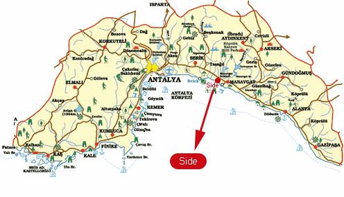
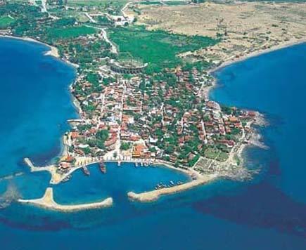
2 Tourism & Geographic Information Systems (GIS) Tourism industry has been taking an important place in economical and social life in Turkey since the end of 1980s. Geographical Information System (GIS) is an information system, which can provide information by integrating all kinds of graphical and descriptive data. 3 Historical Inventory of Side Side had been located at the 75th km on Antalya-Alanya highway. Today Antic Side and Modern Side are living together. It is in the Pamphilia cultural region. 4 2
3 5 6 3
4 GIS and Management GISs will allow planners and other city officials to more easily use the benefits of predictive dynamic urban models and integrate them in collaborative spatial decision making processes. Historical Source Management: GIS and geographic information Technologies in general are used quite infrequently in studies of history and historical geography. 7 GIS and Management Planning: Geographic Information Systems (GISs) technology allows the matching of recreation potential with the characteristics of the regions. The capability of a GIS to allow rapid modification, addition or removal of constraints and to investigate the complex interrelations between the thematic layers is attractive for resource management and planning problems. Decision: The goal of GIS and tourism destination management is to provide guidance for the creation of a comprehensive system that can serve as the basis for the organization of information currently maintained on independent systems. 8 4
5 Tourism Information Systems In order to construct a tourism information system, tourism maps must be produced first. After providing the maps, the graphical information related to the region must be transferred into computer via scanner or AD converter. Graphical and non-graphical data are processed together by means of GIS software so that the main structure of TIS could be constructed. 9 Application 10 5

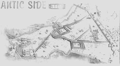
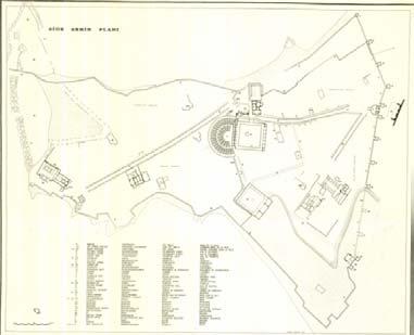
6 Achieve Documents It is get the public plan of Side and digitize to Arc GIS 9.2 software. For the next step, in order to extract documents related to study area, a copy of current documents was taken, also all documents such as books, magazines etc. about the region were searched

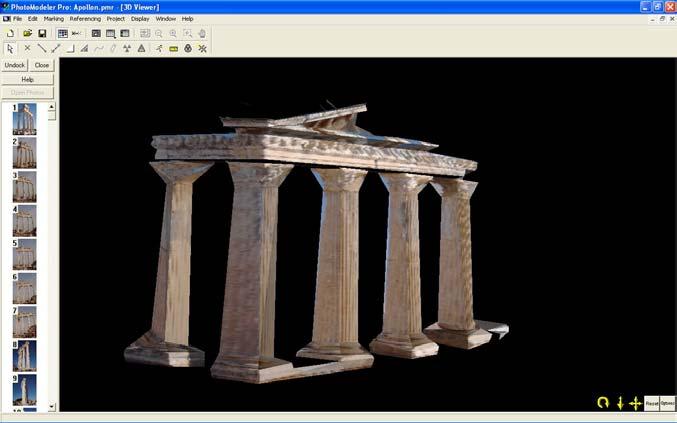
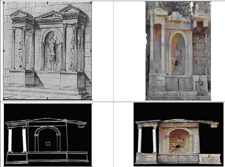
7 Photogrammetry Points, temporarily marked on the historical objects of which photogrametrical 3D models would be constructed, were measured by an electronic distance meter In a way that x,y,z coordinates could be obtained. Appropriate ones among photographic data were selected during office work. It was considered for selection that each point should be viewed at least in two pictures. To avoid loss of detail in high detailed parts, more images were used then the selected photos were transferred into Photomodeler software
8

9 17 Results Nowadays one of the important problems in foundations is to access information rapidly when it is needed. One of the important problems in is lack of rapid accessing capability to information when necessary. Historical and Cultural Places of using GIS can be progressed the professional procedure. For this example study, it must be cared that cultural and historical heritages should not be damaged new buildings and structures must be established in attention. 18 9
10 Thank you 19 10
Dr.Ismail Bulent GUNDOGDU
 A NEW APPROACH FOR GEOGRAPHICAL INFORMATION SYSTEM-SUPPORTED MAPPING OF TRAFFIC ACCIDENT DATA Dr.Ismail Bulent GUNDOGDU Selcuk University, Engineering and Architecture Faculty Geodesy and Photogrammetry
Geography (GEOG) Courses
 Courses") Geography (GEOG) 1 Geography (GEOG) Courses GEOG 100. Introduction to Human Geography. 4 (GE=D4) Introduction to the global patterns and dynamics of such human activities as population growth and movements,
Geography (GEOG) 1 Geography (GEOG) Courses GEOG 100. Introduction to Human Geography. 4 (GE=D4) Introduction to the global patterns and dynamics of such human activities as population growth and movements,
Dr.Sinisa Vukicevic Dr. Robert Summers
 Dr.Sinisa Vukicevic Dr. Robert Summers "Planning" means the scientific, aesthetic, and orderly disposition of land, resources, facilities and services with a view to securing the physical, economic and
3D Laser Scanning for Digital Preservation and Dissemination of Cultural Heritage
 3D Laser Scanning for Digital Preservation and Dissemination of Cultural Heritage Main scanned objects - Four Temples of Different Religions in Sofia Eng. Zlatan Zlatanov, Eng. Milush Blagoev, Irina Nikoevska
Alleghany County Schools Curriculum Guide GRADE/COURSE: World Geography
 GRADE/COURSE: World 2013-14 GRADING PERIOD: 1 st Six Weeks Time Frame Unit/SOLs SOL # Strand Resource Assessment 8 days* The student will use maps, globes, satellite images, photographs, or diagrams to
World Geography TEKS 2nd Nine Weeks. Unit of Study Regional Studies; U.S. and Canada Regional Studies; Latin America; and Europe
 World Geography TEKS 2nd Nine Weeks Unit of Study Regional Studies; U.S. and Canada Regional Studies; Latin America; and Europe 1) History. The student understands how geography and processes of spatial
GIS = Geographic Information Systems;
 What is GIS GIS = Geographic Information Systems; What Information are we talking about? Information about anything that has a place (e.g. locations of features, address of people) on Earth s surface,
Understanding Geographic Information System GIS
 Understanding Geographic Information System GIS What do we know about GIS? G eographic I nformation Maps Data S ystem Computerized What do we know about maps? Types of Maps (Familiar Examples) Street Maps
GIS INTEGRATION OF DATA COLLECTED BY MOBILE GPSSIT
 GIS INTEGRATION OF DATA COLLECTED BY MOBILE GPSSIT S.Savaş DURDURAN, Özşen ÇORUMLUOĞLU, Đbrahim KALAYCI and Fatih GÜL Selcuk University, Geodesy and Photogrammetry Dept. Konya-TURKĐYE ABSTRACT: Rapid developments
Content Area: Social Studies Standard: 1. History Prepared Graduates: Develop an understanding of how people view, construct, and interpret history
 Standard: 1. History Develop an understanding of how people view, construct, and interpret history 1. Organize and sequence events to understand the concepts of chronology and cause and effect in the history
Geographic Information Systems (GIS) in Urban Planning
 in Urban Planning") Geographic Information Systems (GIS) in Urban Planning Ph.D. Sonila Xhafa State University of Tirana, Geography Department email: sonilaxhafa@gmail.com Ph.D. Albana Kosovrasti State University of Tirana,
Geographic Information Systems (GIS) in Urban Planning Ph.D. Sonila Xhafa State University of Tirana, Geography Department email: sonilaxhafa@gmail.com Ph.D. Albana Kosovrasti State University of Tirana,
Optimized positioning for accommodation centers in GIS using AHP techniques; a case study: Hamedan city
 Journal of Tourism & Hospitality Research Islamic Azad University, Garmsar Branch Vol. 2, No. 2, Autumn 2012, Pp.19-29 Optimized positioning for accommodation in GIS using AHP techniques; a case study:
FUTURE COURSES AND CAREERS
 FUTURE COURSES AND CAREERS IN GEOGRAPHY CGC1D Ms. Hyndman PHYSICAL GEOGRAPHY: PATTERNS, PROCESSES AND INTERACTIONS CGF3M Grade 11 course This course examines the major patterns of physical geography and
The maps in this resource can be freely modified and reproduced in the classroom only.
 Teacher's Notes In this activity, students work collaboratively to explore sections of old and new maps. By closely examining these documents, students learn to see maps as more than just tools for locating
 Boone County GIS has the right to inquire about and investigate the use of any requested products and deny access to anyone based on concerns relating to privacy, security, public health, public safety,
3D CARTOGRAPHY IN URBAN ENVIRONMENTS FOR MUNICIPAL ADMINISTRATIONS
 3D CARTOGRAPHY IN URBAN ENVIRONMENTS FOR MUNICIPAL ADMINISTRATIONS Andreea Calugaru Andreea Calugaru, Paula Florina Anca, Alexandru Vasile a.esri Romania 8 Roma, Bucharest, Romania 011774 0212339086, 0212339088,
An Internet-based Agricultural Land Use Trends Visualization System (AgLuT)
") An Internet-based Agricultural Land Use Trends Visualization System (AgLuT) Prepared for Missouri Department of Natural Resources Missouri Department of Conservation 07-01-2000-12-31-2001 Submitted by
An Internet-based Agricultural Land Use Trends Visualization System (AgLuT) Prepared for Missouri Department of Natural Resources Missouri Department of Conservation 07-01-2000-12-31-2001 Submitted by
Desktop GIS for Geotechnical Engineering
 Desktop GIS for Geotechnical Engineering Satya Priya Deputy General Manager (Software) RMSI, A-7, Sector 16 NOIDA 201 301, UP, INDIA Tel: +91-120-2511102 Fax: +91-120-2510963 Email: Satya.Priya@rmsi.com
AP Human Geography Free Response Questions Categorized
 AP Human Geography Free Response Questions Categorized 2002-2010 2. Population (13-17%) 3. Over the past 150 years, Europe has changed from a source to a destination region for international migration.
Kenneth Melchert (Senior Statistician - Regional Liaison Officer)
") Sourcing Spatial Data from Local Government Getting the Data Right The Supplier s Perspective Presenter: Kenneth Melchert (Senior Statistician - Regional Liaison Officer) Information Products and Services
Sourcing Spatial Data from Local Government Getting the Data Right The Supplier s Perspective Presenter: Kenneth Melchert (Senior Statistician - Regional Liaison Officer) Information Products and Services
GENERATION OF 3D CITY MODELS FROM TERRESTRIAL LASER SCANNING AND AERIAL PHOTOGRAPHY: A CASE STUDY
 GENERATION OF 3D CITY MODELS FROM TERRESTRIAL LASER SCANNING AND AERIAL PHOTOGRAPHY: A CASE STUDY Hakan KARABORK 1, Fatih SARI 1 1 Selcuk University in Konya, Faculty of Engineering and Architecture Konya,
Geographic information for Strasbourg : from historical land register to 3D GIS city modelling 09/07/2017
 Geographic information for Strasbourg : from historical land register to 3D GIS city modelling 09/07/2017 Table of contents 1. Introduction of Strasbourg 2. A century of land surveying and cadastre 3.
WELCOME. To GEOG 350 / 550 Introduction to Geographic Information Science: Third Lecture
 WELCOME To GEOG 350 / 550 Introduction to Geographic Information Science: Third Lecture 1 Lecture 3: Overview Geographic Information Systems (GIS) A brief history of GIS Sources of information for GIS
STEREO ANALYST FOR ERDAS IMAGINE Stereo Feature Collection for the GIS Professional
 STEREO ANALYST FOR ERDAS IMAGINE Stereo Feature Collection for the GIS Professional STEREO ANALYST FOR ERDAS IMAGINE Has Your GIS Gone Flat? Hexagon Geospatial takes three-dimensional geographic imaging
Geographic Information Systems (GIS) in Environmental Studies ENVS Winter 2003 Session III
 in Environmental Studies ENVS Winter 2003 Session III") Geographic Information Systems (GIS) in Environmental Studies ENVS 6189 3.0 Winter 2003 Session III John Sorrell York University sorrell@yorku.ca Session Purpose: To discuss the various concepts of space,
Geographic Information Systems (GIS) in Environmental Studies ENVS 6189 3.0 Winter 2003 Session III John Sorrell York University sorrell@yorku.ca Session Purpose: To discuss the various concepts of space,
Al Ain Cultural Heritage Management Strategy 1/102
 AL AIN CULTURAL HERITAGE MANAGEMENT STRATEGY EXECUTIVE SUMMARY The cultural heritage of Al Ain is rich and varied; it consists of tangible and intangible resources and incorporates archaeological sites,
Least-Cost Transportation Corridor Analysis Using Raster Data.
 Least-Cost Transportation Corridor Analysis Using Raster Data What is GeoMedia Grid: Key Grid Concepts Vector Model Vector based systems show data by means of a series of points, lines, and polygons. Each
PLANNING (PLAN) Planning (PLAN) 1
 Planning (PLAN) 1") Planning (PLAN) 1 PLANNING (PLAN) PLAN 500. Economics for Public Affairs Description: An introduction to basic economic concepts and their application to public affairs and urban planning. Note: Cross-listed
Planning (PLAN) 1 PLANNING (PLAN) PLAN 500. Economics for Public Affairs Description: An introduction to basic economic concepts and their application to public affairs and urban planning. Note: Cross-listed
GIS Geographical Information Systems. GIS Management
 GIS Geographical Information Systems GIS Management Difficulties on establishing a GIS Funding GIS Determining Project Standards Data Gathering Map Development Recruiting GIS Professionals Educating Staff
National Cartographic Center
 National Cartographic Center NCC activities and accomplishments Activities of national organizations, institutions and universities in field of geomatics Large scale maps Medium scale maps Small scale
A QUANTITATIVE APPROACH FOR SUSTAINABLE URBAN WATER MANAGEMENT SUPPORT
 A QUANTITATIVE APPROACH FOR SUSTAINABLE URBAN WATER MANAGEMENT SUPPORT ABSTRACT Water resources play multiple urban roles. Available literature shows that the roles are mainly perceived in economic and
Investigation of the Effect of Transportation Network on Urban Growth by Using Satellite Images and Geographic Information Systems
 Presented at the FIG Congress 2018, May 6-11, 2018 in Istanbul, Turkey Investigation of the Effect of Transportation Network on Urban Growth by Using Satellite Images and Geographic Information Systems
DEPARTMENT OF GEOGRAPHY B.A. PROGRAMME COURSE DESCRIPTION
 DEPARTMENT OF GEOGRAPHY B.A. PROGRAMME COURSE DESCRIPTION (3 Cr. Hrs) (2340100) Geography of Jordan (University Requirement) This Course pursues the following objectives: - The study the physical geographical
Council Workshop on Neighbourhoods Thursday, October 4 th, :00 to 4:00 p.m. Burlington Performing Arts Centre
 Council Workshop on Neighbourhoods Thursday, October 4 th, 2012 1:00 to 4:00 p.m. Burlington Performing Arts Centre Agenda Introductions Warm-Up Exercise Presentation Exercise Neighbourhood Planning Break
University of Lusaka
 University of Lusaka BSPH 315 Health Mapping & GIS Topic: Background of GIS Content: 1. Aim of the course 2. What do you know about GIS? 3. Difference between geographic data and geographic information
Visualization of Places Based on Network Analysis through GIS
 Dagon University Research Journal 2014, Vol. 6 Visualization of Places Based on Network Analysis through GIS Win Win Shwe * Abstract Geographic Information System is a computer-based tool for mapping and
COMPREHENSIVE LAND-USE MANAGEMENT UNDERSTANDING THE INTERRELATIONSHIP BETWEEN SPATIAL PLANNING, LAND MANAGEMENT AND LAND ADMINISTRATION
 COMPREHENSIVE LAND-USE MANAGEMENT UNDERSTANDING THE INTERRELATIONSHIP BETWEEN SPATIAL PLANNING, LAND MANAGEMENT AND LAND ADMINISTRATION Daniel Galland & Stig Enemark Department of Development and Planning
Mapping Maine s Working Waterfront: for Our Heritage and Economy
 Mapping Maine s Working Waterfront: for Our Heritage and Economy Abstract Mapping Maine s Working Waterfronts is a collaborative project led by the Island Institute that inventories the state s current
TOWARDS STRATEGIC SPATIAL PLANNING IN JAMAICA: THE NATIONAL SPATIAL PLAN
 TOWARDS STRATEGIC SPATIAL PLANNING IN JAMAICA: THE NATIONAL SPATIAL PLAN JIEP 5th Biennial Conference on the Environment: Balancing National Development and Environmental Protection June 6, 2011 Jamaica
DEVELOPPING A LAND INFORMATION SYSTEM FOR THE UNIFICATION OF THE ARCHAEOLOGICAL SITES OF ATHENS. Efi Dimopoulou, Vasso Nikolaidou, Panagiotis Zendelis
 DEVELOPPING A LAND INFORMATION SYSTEM FOR THE UNIFICATION OF THE ARCHAEOLOGICAL SITES OF ATHENS Efi Dimopoulou, Vasso Nikolaidou, Panagiotis Zendelis Laboratory of Photogrammetry, Faculty of Surveying
Exploring the boundaries of your built and natural world. Geomatics
 Exploring the boundaries of your built and natural world Geomatics Before the Luxor brought magic to the Las Vegas strip and before the South LRT extension in Edmonton gave residents a new route to travel,
Looking at Communities: Comparing Urban and Rural Neighborhoods
 Looking at Communities: Comparing Urban and Rural Neighborhoods OVERVIEW & OBJECTIVES Our urban areas have become so dominant that frequently the children we teach have no connection with and very few
ABSTRACT I. INTRODUCTION II. OBJECTIVES
 2017 IJSRSET Volume 3 Issue 1 Print ISSN: 2395-1990 Online ISSN : 2394-4099 Themed Section: Engineering and Technology GIS Based Urban Road Network Analysis in Khartoum Center Mohamed ElAmin Ahmed Babiker,
Curriculum Links AS and A level Field Studies
 Equipment Includes Human Geography Coastal Management Students examine the conflicts that arise from coastal erosion and the options for coastal management. They investigate different types of coastal
CK107 BA in Geographical and Archaeological Sciences
 CK107 BA in Geographical and Archaeological Sciences CK107 BA in Geographical and Archaeological Science Geography and Archaeology are closely related disciplines, concerned with concepts of time and space
Development of the Portal of Cultural Heritage Objects the Kingdom of Poland
 Evgeny KOVALEV, Natalia KOVALEVA Sholokhov Moscow State University for the Humanities, Russia Hadi SALEH Vladimir State University Named After Alexander and Nikolay Stoletovs, Russia Development of the
PRODUCTION DIGITAL MAPPING FLOWCHARTING EXPERIENCES IN CHILE USING MGE MAP PUBLISHER
 PRODUCTION DIGITAL MAPPING FLOWCHARTING EXPERIENCES IN CHILE USING MGE MAP PUBLISHER Leonardo Oyarzun Yarza Jorge Godoy Gutierrez Rodrigo Barriga Vargas ABSTRACT For the conversion from traditional to
Integrated city as a model for a new wave urban tourism
 IOP Conference Series: Earth and Environmental Science PAPER OPEN ACCESS Integrated city as a model for a new wave urban tourism To cite this article: V Ariani 2018 IOP Conf. Ser.: Earth Environ. Sci.
Land Administration and Cadastre
 Geomatics play a major role in hydropower, land and water resources and other infrastructure projects. Lahmeyer International s (LI) worldwide projects require a wide range of approaches to the integration
INVESTIGATION LAND USE CHANGES IN MEGACITY ISTANBUL BETWEEN THE YEARS BY USING DIFFERENT TYPES OF SPATIAL DATA
 INVESTIGATION LAND USE CHANGES IN MEGACITY ISTANBUL BETWEEN THE YEARS 1903-2010 BY USING DIFFERENT TYPES OF SPATIAL DATA T. Murat Celikoyan, Elif Sertel, Dursun Zafer Seker, Sinasi Kaya, Uğur Alganci ITU,
Geography. Programme of study for key stage 3 and attainment target (This is an extract from The National Curriculum 2007)
") Geography Programme of study for key stage 3 and attainment target (This is an extract from The National Curriculum 2007) Crown copyright 2007 Qualifications and Curriculum Authority 2007 Curriculum aims
Geography Programme of study for key stage 3 and attainment target (This is an extract from The National Curriculum 2007) Crown copyright 2007 Qualifications and Curriculum Authority 2007 Curriculum aims
Economic and Social Council
 United Nations Economic and Social Council Distr.: General 23 May 2012 Original: English E/CONF.101/100 Tenth United Nations Conference on the Standardization of Geographical Names New York, 31 July 9
3D BUILDING MODELS IN GIS ENVIRONMENTS
 A. N. Visan 3D Building models in GIS environments 3D BUILDING MODELS IN GIS ENVIRONMENTS Alexandru-Nicolae VISAN, PhD. student Faculty of Geodesy, TUCEB, alexvsn@yahoo.com Abstract: It is up to us to
Cultural Routes of the Council of Europe - Glossary
 Cultural Routes of the Council of Europe - Glossary Below is a collection of terms linked to Cultural Routes of the Council of Europe. The glossary is taken from the book Cultural Routes management: from
Belfairs Academy GEOGRAPHY Fundamentals Map
 YEAR 12 Fundamentals Unit 1 Contemporary Urban Places Urbanisation Urbanisation and its importance in human affairs. Global patterns of urbanisation since 1945. Urbanisation, suburbanisation, counter-urbanisation,
Introducing the. a partnership of
 Introducing the a partnership of Background Need for online atlas identified by managers and researchers to make coastal data available Shoreline data Ocean and coastal resources Sea-level rise potential
Community Engagement in Cultural Routes SiTI Higher Institute on Territorial Systems for Innovation Sara Levi Sacerdotti
 Transnational Workshop Wroclaw, 7th-8th December 2016 Community Engagement in Cultural Routes SiTI Higher Institute on Territorial Systems for Innovation Sara Levi Sacerdotti levi@siti.polito.it TAKING
A Map Through Time Virtual Historic Cities
 A Map Through Time Virtual Historic Cities NEW WAYS OF EXPLORING DIGITAL COLLECTIONS FLORIDA INTERNATIONAL UNIVERSITY JAMIE ROGERS Coral Gables Virtual Historic City & Unearthing St. Augustine s Colonial
EXPLANATION OF G.I.S. PROJECT ALAMEIN FOR WEB PUBLISHING
 EXPLANATION OF G.I.S. PROJECT ALAMEIN FOR WEB PUBLISHING Compilato: Andrea De Felici Rivisto: Approvato: Daniele Moretto ARIDO S President Versione: 1.0 Distribuito: 28/06/2013 1 TABLE OF CONTENTS 1. INTRODUCTION..3
Part : General Situation of Surveying and Mapping. The Development of Surveying and Mapping in China. The contents
 The Development of Surveying and Mapping in China Dr. Ping Xiao China.P.R The contents Part : General Situation of Surveying and Mapping 1. The legal systems of surveying and mapping 2. The technologies
REPORT ON INVESTMENTS
 REPORT ON INVESTMENTS D.T2.3.3 Investments for technical equipment for the implementation of Web-GIS platform in Mantova 1 Local support group designing Mantova Web-GIS platform. Picture by Maria Giulia
GEOGRAPHY (GEOGRPHY) Geography (GEOGRPHY) 1
 Geography (GEOGRPHY) 1") Geography (GEOGRPHY) 1 GEOGRAPHY (GEOGRPHY) GEOGRPHY 1040 Planet Earth 4 Credits The features of the natural environment (lithosphere, atmosphere and hydrosphere); their character, distribution, origin
Geography (GEOGRPHY) 1 GEOGRAPHY (GEOGRPHY) GEOGRPHY 1040 Planet Earth 4 Credits The features of the natural environment (lithosphere, atmosphere and hydrosphere); their character, distribution, origin
The purpose of this report is to recommend a Geographic Information System (GIS) Strategy for the Town of Richmond Hill.
 Strategy for the Town of Richmond Hill.") Staff Report for Committee of the Whole Meeting Department: Division: Subject: Office of the Chief Administrative Officer Strategic Initiatives SRCAO.18.12 GIS Strategy Purpose: The purpose of this report
Staff Report for Committee of the Whole Meeting Department: Division: Subject: Office of the Chief Administrative Officer Strategic Initiatives SRCAO.18.12 GIS Strategy Purpose: The purpose of this report
A Comprehensive Inventory of the Number of Modified Stream Channels in the State of Minnesota. Data, Information and Knowledge Management.
 A Comprehensive Inventory of the Number of Modified Stream Channels in the State of Minnesota Data, Information and Knowledge Management Glenn Skuta Environmental Analysis and Outcomes Division Minnesota
GEOGRAPHY - HIGHER LEVEL
 M.24 AN ROINN OIDEACHAIS AGUS EOLAÍOCHTA LEAVING CERTIFICATE EXAMINATION 2000 GEOGRAPHY - HIGHER LEVEL MONDAY, 12 JUNE AFTERNOON 2.00 TO 5.20 Four questions to be answered, namely Question 1, Question
Brian D. George. GIMS Specialist Ohio Coastal Atlas Project Coordinator and Cartographer. Impacts and Outcomes of Mature Coastal Web Atlases
 Ohio Coastal Atlas Project Brian D. George GIMS Specialist Ohio Coastal Atlas Project Coordinator and Cartographer Ohio Department of Natural Resources Office of Coastal Management Sandusky, OH Impacts
Contents... GIS Approach. 4D Geo-referenced Database Approach for GIS. G IS Specific GIS Applications. FIG Working Week 2004.
 FIG Working Week 2004 4D Geo-referenced Database Approach for GIS Components of GIS GIS Approach How to Produce Maps Contents... Everything is moving with Earth by Time Why 4D Geo-referenced Database Design
SOCIAL STUDIES GRADE 5. I Can Checklist Office of Teaching and Learning Curriculum Division REGIONS AND PEOPLE OF THE WESTERN HEMISPHERE
 SOCIAL STUDIES REGIONS AND PEOPLE OF THE WESTERN HEMISPHERE GRADE 5 I Can Checklist 2015-2016 Aligned with Ohio s Learning Standards for Social Studies Office of Teaching and Learning Curriculum Division
GEOGRAPHY (GE) Courses of Instruction
 Courses of Instruction") GEOGRAPHY (GE) GE 102. (3) World Regional Geography. The geographic method of inquiry is used to examine, describe, explain, and analyze the human and physical environments of the major regions of the
GEOGRAPHY (GE) GE 102. (3) World Regional Geography. The geographic method of inquiry is used to examine, describe, explain, and analyze the human and physical environments of the major regions of the
Management and Controlling Tourism Activity and Services (MCTAS) at ALBAHA City Using GIS
 at ALBAHA City Using GIS") 451 Management and Controlling Tourism Activity and Services (MCTAS) at ALBAHA City Using GIS 1 Mohmed Sirelkhtem Adrees, 2 Majzoob Kamal Aldein Omer, 3 Osama E. Sheta 1 Department of Information Technology,
451 Management and Controlling Tourism Activity and Services (MCTAS) at ALBAHA City Using GIS 1 Mohmed Sirelkhtem Adrees, 2 Majzoob Kamal Aldein Omer, 3 Osama E. Sheta 1 Department of Information Technology,
Programme Study Plan
 Faculty of Social and Life Sciences Programme Study Plan Geographic Information Systems Programme Code: Programme Title: TGLIT Engineering: Surveying Technology and Geographical IT Credits: 180 Programme
Analysis of Rural-Urban Systems and Historic Climate Data in Mexico
 Analysis of Rural-Urban Systems and Historic Climate Data in Mexico Global Conference on Big Data for Official Statistics October 2015, Abu Dhabi, UAE RURAL-URBAN SYSTEMS Rural-Urban Systems: Functional
Model development for WebAtlas system applying in administration management.
 Model development for WebAtlas system applying in administration management. Bui Ngoc Quy, Vo Ngọc Dung, Nguyen Danh Duc, University of mining and geology, Viet Nam Key words: Webatlas, Web Map, Electronic
STATE GEOGRAPHIC INFORMATION DATABASE
 STATE GEOGRAPHIC INFORMATION DATABASE Data Information and Knowledge Management STATE GEOGRAPHIC INFORMATION DATABASE EXECUTIVE SUMMARY Utah has developed one of the most comprehensive statewide GIS resources
Introduction to Geographic Information Systems
 Introduction to Geographic Information Systems Geography 176A Fall 2013 The sequence Geog 176A - Introduction to Geographic Information Systems, 4.0, Clarke Introduction to modern spatial data processing,
History and Social Science: Advanced Placement Human Geography
 History and Social Science: Advanced Placement Human Geography A.P. Human Geography Curriculum for Loudoun County Public Schools Ashburn, Virginia 2016 This curriculum document for Advanced Placement Human
BACHELOR OF ARTS GEOGRAPHY
 BACHEL OF ARTS General Education Categories (4-5 credits total) FYS First Year Seminar W-I Written Communication - Level I OC Oral Communication PGR Personal Growth & Responsibility CEA Creative Expression
Contents. Introduction Study area Data and Methodology Results Conclusions
 Modelling Spatial Changes in Suburban Areas of Istanbul Using Landsat 5 TM Data Şinasi Kaya(Assoc. Prof. Dr. ITU) Elif Sertel(Assoc. Prof. Dr. ITU) Dursun Z. Şeker(Prof. Dr. ITU) 1 Contents Introduction
This Week s Topics. GIS and Forest Engineering Applications. FE 257. GIS and Forest Engineering Applications. Instructor Information.
 FE 257. GIS and Forest Engineering Applications Introduction Instructor Information Associate Professor in FERM Department Instructor for FE 257, FE 480, FE 432/532 PhD from Forest Resources with minor
GIS Visualization: A Library s Pursuit Towards Creative and Innovative Research
 GIS Visualization: A Library s Pursuit Towards Creative and Innovative Research Justin B. Sorensen J. Willard Marriott Library University of Utah justin.sorensen@utah.edu Abstract As emerging technologies
Joanne N. Halls, PhD Dept. of Geography & Geology David Kirk Information Technology Services
 Joanne N. Halls, PhD Dept. of Geography & Geology David Kirk Information Technology Services Geographic Information Systems manage and analyze data to solve spatial problems. Real World Abstraction Analysis
Introduction to GIS. Dr. M.S. Ganesh Prasad
 Introduction to GIS Dr. M.S. Ganesh Prasad Department of Civil Engineering The National Institute of Engineering, MYSORE ganeshprasad.nie@gmail.com 9449153758 Geographic Information System (GIS) Information
Tourism Map of Seiyun City, Yemen
 King Fahd University of Petroleum and Minerals CRP 514 Geographic Information Systems (GIS) Term project Tourism Map of Seiyun City, Yemen Prepared by: Fahmi S. Baroished ID: 201001440 Mohammed A. Al-Haddad
GEOGRAPHIC INFORMATION SYSTEMS SPECIALIST 3 DEFINITION:
 Hunterdon County Department of Planning and Land Use Vacancy: Geographic Information Systems Specialist 3 Full Time: 40 Hours per Week Compensation: $42,000.00 per year GEOGRAPHIC INFORMATION SYSTEMS SPECIALIST
Towards National Geographic Information System in Nepal
 2 nd High Level Forum on Global Geospatial Information Management, Qatar National Convention Centre, Doha, Qatar, 4 6 February, 2013 Towards National Geographic Information System in Nepal Krishna Raj
Airborne Corridor-Mapping. Planning and documentation of company infrastructure: precise, rapid, and cost effective
 Airborne Corridor-Mapping Planning and documentation of company infrastructure: precise, rapid, and cost effective Technology Airborne Laser-Scanning, digital orthophotos and thermal imaging: one flight
Paper Title Study on Survey and Management of Rural Resource. Author s name Sang-bum Kim, Sang-Young Rhee
 Paper Title Study on Survey and Management of Rural Resource Author s name Sang-bum Kim, Sang-Young Rhee Paper Abstract The aim of this study is to suggest how we can preserve and manage the rural resource
UTAH S STATEWIDE GEOGRAPHIC INFORMATION DATABASE
 UTAH S STATEWIDE GEOGRAPHIC INFORMATION DATABASE Data Information and Knowledge Management NASCIO Awards 2009 STATE GEOGRAPHIC INFORMATION DATABASE B. EXECUTIVE SUMMARY Utah has developed one of the most
GEOGRAPHY, ENVIRONMENT, AND SUSTAINABILITY (GES)
") Geography, Environment, and Sustainability (GES) 1 GEOGRAPHY, ENVIRONMENT, AND SUSTAINABILITY (GES) GES 102 The Historical Geography of the Western World 3 A study of the geographical factors which combine
Geography, Environment, and Sustainability (GES) 1 GEOGRAPHY, ENVIRONMENT, AND SUSTAINABILITY (GES) GES 102 The Historical Geography of the Western World 3 A study of the geographical factors which combine
BIG IDEAS. Area of Learning: SOCIAL STUDIES Urban Studies Grade 12. Learning Standards. Curricular Competencies
 Area of Learning: SOCIAL STUDIES Urban Studies Grade 12 BIG IDEAS Urbanization is a critical force that shapes both human life and the planet. The historical development of cities has been shaped by geographic,
Land Use in the context of sustainable, smart and inclusive growth
 Land Use in the context of sustainable, smart and inclusive growth François Salgé Ministry of sustainable development France facilitator EUROGI vice president AFIGéO board member 1 Introduction e-content+
Economic and Social Council 2 July 2015
 ADVANCE UNEDITED VERSION UNITED NATIONS E/C.20/2015/11/Add.1 Economic and Social Council 2 July 2015 Committee of Experts on Global Geospatial Information Management Fifth session New York, 5-7 August
Lecture 9: Reference Maps & Aerial Photography
 Lecture 9: Reference Maps & Aerial Photography I. Overview of Reference and Topographic Maps There are two basic types of maps? Reference Maps - General purpose maps & Thematic Maps - maps made for a specific
Gis for Land Management: An Overview on Italy
 Gis for Land Management: An Overview on Italy Paola RONZINO, Italy Key words: Cartography, Land Management, Spatial Planning, Urban Renewal, Spatial Information, Environment SUMMARY The introduction of
Introduction to Human Geography & Geographic Concepts
 Introduction to Human Geography & Geographic Concepts What is Geography? Literal definition: Description of the Earth Serves as a bridge between physical and human sciences the study of the earth and its
Introduction and Project Overview
 Greater New Orleans Regional Land Use Modeling GIS Techniques in a P olitical C ontext Louisiana Remote Sensing and GIS Workshop Wednesday, April 24, 2013 Working Towards a Shared Regional Vision Introduction
INFORMATION SYSTEMS AND DIGITAL CARTOGRAPHY FOR SPATIAL PLANNING IN POLAND
 INFORMATION SYSTEMS AND DIGITAL CARTOGRAPHY FOR SPATIAL PLANNING IN POLAND Krzysztof Koreleski, Faculty of Environmental Engineering and Geodesy, University of Agriculture in Kraków, Poland Abstract There
GEOMATICS. Shaping our world. A company of
 GEOMATICS Shaping our world A company of OUR EXPERTISE Geomatics Geomatics plays a mayor role in hydropower, land and water resources, urban development, transport & mobility, renewable energy, and infrastructure
THE USE OF GEOMATICS IN CULTURAL HERITAGE AND ARCHAEOLOGY FOR VARIOUS PURPOSES
 THE USE OF GEOMATICS IN CULTURAL HERITAGE AND ARCHAEOLOGY FOR VARIOUS PURPOSES FEBRUARY 2013 AL BEIDA GEOPLAN CONTENT Company Profile Concept Objectives and Strategies Data Production Methods Data Samples
Application of GIS in Public Transportation Case-study: Almada, Portugal
 Case-study: Almada, Portugal Doutor Jorge Ferreira 1 FSCH/UNL Av Berna 26 C 1069-061 Lisboa, Portugal +351 21 7908300 jr.ferreira@fcsh.unl.pt 2 FSCH/UNL Dra. FCSH/UNL +351 914693843, leite.ines@gmail.com