Experiential Learning Module: Is it GREEN in our Backyard? (or Space in the City ) 1
|
|
|
- Archibald Robinson
- 5 years ago
- Views:
Transcription
1 Experiential Learning Module: Is it GREEN in our Backyard? (or Space in the City ) 1 BIG QUESTION How do human activities impact the environment and how can we respond to it? OVERVIEW Understanding land use and the impact of human activity is important when learning about the environment and biodiversity. To scaffold student engagement with and understanding of such concerns, they will examine their communities using an inquiry place-based learning approach. Students will engage in the process of interpreting and extrapolating information from a remotely sensed image of their neighborhood, including comparing and contrasting historical and contemporary images, validating the images, examining secondary data to add perspective, and evaluate land use decisions to make informed recommendations about land use in the community. The module consists of four challenges: 1. Students will develop definitions of green space, compare and contrast them with definitions of open space, and apply to spaces in the neighborhood. 2. By looking at US Census maps, students will be able to list how population patterns are changing. 3. By looking at remotely sensed images with GIS layers, students will be able to identify space in their city that is available for conversion to different uses for the benefit of their community and the environment. 4. Based on their findings, student will create a defendable proposal for the development of an open space in their area that they believe is available for conversion for the benefit of that community and environment. Content focus: Earth Science, Geography, People-Environment, Population Skill focus: Map Interpretation, Remote Sensing, Fieldwork and Observation, Data Analysis Level of Inquiry: Confirmation to Open Key Concepts Environmental impact, Urbanization, Urban planning, Vegetation cover, Green space, Remote sensing Grade Level: 9 th to 12 th grades Duration for Lesson: 4 to 7 days Overview of Student Resources (Worksheets) by Module Section: Engage- Student resources I, II III, IV Explore- Historical Google Earth Images for Selected Blocks (choose a different block for each group) Current Google Earth Images for Selected Blocks (same blocks for comparison to the historic images) Appendices A and B, Student Resources V to VIII Explain- Internet access for secondary data search Student Resources IX, X, XI Apply- Student Resources XII and XIII Connections- Student Resource XIV and XV 1 These challenges have been created in collaboration with one of the project s teacher advisors, Jackie Kane, a physics teacher at St. Ursula Academy in Toledo, Ohio. 1
2 STANDARDS Focus Standards Next Generation Science Standards HS-LS2-7. Design, evaluate, and refine a solution for reducing the impacts of human activities on the environment and biodiversity Disciplinary Core Ideas When evaluating solutions it is important to take into account a range of constraints including cost, safety, reliability and aesthetics and to consider social, cultural and environmental impacts. Moreover, anthropogenic changes (induced by human activity) in the environment including habitat destruction, pollution, introduction of invasive species, overexploitation, and climate change can disrupt an ecosystem and threaten the survival of some species. (HS-LS2-7) College, Career, and Civic Life D2.Geo Use maps, satellite images, photographs, and other representations to explain relationships between the locations of places and regions and their political, cultural, and economic dynamics. National Geography Standards: Geography Standard 14. How human actions modify the physical environment Prior Standards: Anticipated Prior Knowledge Next Generation Science Standards MS-ESS3-3. Apply scientific principles to design a method for monitoring and minimizing a human impact on the environment. College, Career, and Civic Life D2.Geo Use geospatial and related technologies to create maps to display and explain the spatial patterns of cultural and environmental characteristics. LEARNING TARGETS By the end of this module students will be able to recommend different uses for open spaces in the neighborhood that could benefit the community and the environment. They will do this through identifying locations and measuring sizes of open spaces by comparing current and historical remote sensing images. 2
. However, some counties are more crowded than others.")
3 Is it GREEN in our Backyard? CONTENT BACKGROUND: Urbanization in the United States has increased, particularly since the middle of the twentieth century. According to the Population Data Sheet for 2015, 81% of people in this country live in urban areas (Population Data Sheet 2015). However, some counties are more crowded than others. In other words, population density varies by county. In addition to population density, the physical and human geography of each county is different. For example, some counties are more urban than others. The map shows population density of counties in the United States in Urban areas have higher densities than rural. Which regions of the country do you think are more urbanized? Climate regions and landforms are diverse across the United States. People are employed in different professions depending on where they live. Over time we have used the land in changing ways and our impact on the environment can be seen in the landscapes of our local communities. One way to measure our impact on the environment is to use the following formula: I (Impact on the Environment) = P (Population) X A (Affluence) X T (Technology) Population can be determined by examining population density, while affluence (or standard of living) could be measured using a variable such as income per capita. The impact of technology is more difficult to assess, however. In many cases, people suggest that the increasing use of technology has a 3
4 negative impact on the environment, but this is not always the case. In fact, new advances in technology, such as alternative energy sources, can improve human s impact on the environment. For this lesson, students will focus on urbanization and land cover. Using remote sensing and spatial thinking, students will examine the changing landscapes of their communities over time. I. ENGAGE Understanding the concepts of green space and open space A. Mental Mapping (Student Resource I) 1. Have students sketch a mental map of the neighborhood around the school, circle three locations that they consider green spaces, and provide a one to two sentence description of each green space including its condition and use. 2. Discussion Working in small groups, students discuss where and why they located the green spaces on their maps. B. Challenge 1: Defining Green/Open space (Student Resource II) 1. In an effort to develop understanding of green space, engage students in drafting a classroom definition of the term. Begin with students working individually in response to the prompt, located on Student Resource I to compose a personal definition of green space. 2. When students have composed a definition individually, come together as a whole class sharing ideas until a consensus definition is reached. Compare with the definition provided below. Definition: Green space (land that is partly or completely covered with grass, trees, shrubs, or other vegetation). Green space includes parks, community gardens, and cemeteries. Source: C. Discussion: Compare/contrast 1. Reinforce the concept of green space, the main elements included in a definition, and why this is important to communities. Discuss the concept of open space. For more information seehttp://www3.epa.gov/region1/eco/uep/openspace.html] Or use this approach for comparison: 1. Working in small groups, ask students to locate a definition of open space. Have them compare and contrast this definition with the definition for green space. 2. Ask each group to come up with a definition for open space. 3. As a class, develop a Venn diagram comparing and contrasting the two concepts. D. Assessment: Student Resource III: 1. Provide students with visuals or a list of the following features and ask students to identify whether each is an open space, green space or both; streets, car park, forest, parks, community garden, basketball court, baseball field, football field, etc. 4
5 E. Evaluation 1. Assign a score base on the number of keywords used in the personal definition. Key words include but are not limited; open, land, shrubs, trees, grass, greenery, hedges, parks and gardens. Challenge 2: How are population patterns are changing in the United States? By looking at US Census maps, students will be able to list how city populations are changing. Begin by having students compare and contrast maps made by the United States Census Bureau of population by country for the years 2000 and Have them work in groups to identify trends in population change for that decade (Student Resource IV). II. EXPLORE Reading Remotely Sensed Images A. Stump the Class: Student Resource V 1. Select 2 to 4 images, such as those in Appendix A, and engage students in identifying the features on each image. Each student, using Student Resource V should list three guesses for each image 2. Discuss the guesses made by students and their reasons for these. A good source for images is the Google Earth application ( where you can access images for different years. B. Challenge 3: Using Remotely Sensed Images to Explore a Place (Student Resource VI) Provide students with a current (RSI One) and a historical (RSI Two) remotely sensed image of the same neighborhood and at the same scale. Look for two images that show clearly identifiable change. You could also use the images for a neighborhood in Toledo, OH which is provided in Appendix B. In small groups, students review remote sensed images and complete the tasks on Student Resource VI: 1. Describe RSI One then RSI Two 2. Estimate the proportion of each image allocated to the open spaces, buildings, roads, water, and other. 3. Explain how the estimates were determined. 4. Identify the observed changes between RSI One and RSI Two, both numerically and qualitatively. Using analysis and responses to 1-4 above, as a class: 1. List the observed changes in the green/open spaces between the current and older image. 2. Describe causes of each change. Students may conduct internet search in finding secondary data. 3. Evaluate changes describing positive/negative impacts on the neighborhood. 4. Compare differences/similarities between the mental map (A above) with RSI One. 5. Explain the comparison supported student understanding/thinking. 5
6 Or use this extension (time-permitting): Student Resource VII: Using field work to verify remotely sensed images Organize students to walk around the neighborhood in their groups with the current map in hand. If the area is large, assign groups to different sections of the neighborhood. Students are to; 1. Check the accuracy of the map, making updates to reflect any changes. 2. Present your observations to the rest of the class. D. Assessment Student resource VIII 1. Students should list five things that should be on a map e.g. title, scale, legend, streets, school, buildings, green spaces E. Evaluation 1. For Mental maps, assign same score for all maps drawn. Give extra points for each of the following features if shown on the mental map. Examples include title, scale, legend, streets, school, buildings, green spaces, etc. III. EXPLAIN A. Human activities and their impact on Environment: Student Resource IX Students are to identify any human activity that can cause changes in green space in the neighborhood, over time. Have students illustrate using charts, how the selected activity affects green space in the neighborhood of the school. B. Putting observations into perspective through data analysis: Student Resource X There are several options for data acquisition and analysis. First, student could search for related data, such as median income, per capita income, population, zoning and housing statistics. Potential sources might include the local and county databases, decennial census, the American Community Survey, or the Population Reference Bureau. (Note: when possible, try to get data as close as possible in time to the historic and contemporary maps provided in Steps 1 and 2.) The task for each group is to: 1. Compare the data sets and identify changes that would impact community land use. 2. Determine whether the data set represents changes related to population, affluence, or technology. Explain your supposition. 3. Assess the impact the changes would have on the neighborhood, using data to support the assessment. 4. Propose questions that remain or that came up as a result of this activity. C. Assessment: Student Resource XI Ask students to list three sources of secondary data and give an example of data that can be found in each of these sources. D. Evaluation 1. Assign a score for each human activity identified by students and an additional score for the illustrations made. For each data and data source, assign additional scores. 6
7 IV. APPLY Challenge 4: Connecting Research to Neighborhood Change (Student Resource XII) Students are to imagine that they have been asked to serve as a liaison between neighborhood residents and the city s planning department. Their task is to determine how the green space in the neighborhood has been used in the past, how it used currently, and create a proposal for future use of one location. Questions students can address include: 1. Where applicable, what persistent problems need to be addressed (i.e., abandoned buildings and lots that are not being maintained) 2. How do you suggest addressing the problems? 3. Who are the other individuals and agencies who will be involved in solving the problems identified? 4. Create a PowerPoint presentation to provide concrete suggestions to the planning department of your city. B. Assessment: Student Resource XIII 1. Ask students to identify two roles of a city planner 2. Students should write in two or three sentence the process involved in identifying challenges in their community. C. Evaluation For each problem identified, assign a score and an additional score if students explain the problem. Assign a score for each solution proposed by students and individuals/agencies identified. Give extra points for well-organized PowerPoint presentation. V. CONNECTIONS Real World Experience A. In communities with present or persistent land use challenges, students might assume the roles of different community stakeholders to investigate the use of green space in the neighborhood in regards a specific challenge. They would consult historical maps to understand past use, the current challenge, and assess the proposed changes in use, and/or make proposals for the future (Student Resource XIV). Students should list the main stakeholders in the development of their city research each one's role. 1. Planning Commission 2. Elected officials 3. Concerned neighborhood homeowners 4. Students 5. Owners of affected properties, including homeowners, business owners, and institutions like religious organizations B. Assessment: Student Resource XV Students should list the main stakeholders in the development of their city. 7
8 C. Evaluation Assign score for creative thinking and feasibility of proposals. VI. EXTEND This could be a project for honor s students that links to the standard HS-LS2-7. Design, evaluate, and refine a solution for reducing the impacts of human activities on the environment and biodiversity. The focus can be determined by the teacher and student based on the student's interests. ADDITIONAL RESOURCES 1. Definition of green space and open space 2. Census Data from 3. American Community Survey 4. Google Earth application downloadable at 5. For more Remote Sensing game, 6. For video on urbanization and geospatial technology, use Geospatial Revolution Video. Episode 2: Chapter 1, Creating an Interactive City (6 minutes) REFERENCES Population Data Sheet 2015) Us census bureau, 2010 census Google Earth Next Generation of Science Standard College, Career, and Civic Life Standards National Geography Standards 8


9 Appendix A 9
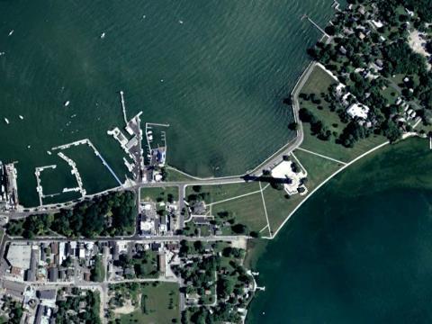
10 Appendix B Current and Historical Remotely Sensed Image of the Scott High School Neighborhood, Toledo, OH How to retrieve Remotely Sensed Images Using Google Earth: Assuming Google Earth is available on the computer, enter the address of the school. [If not, this is a free program that can be downloaded.] For our example: 2400 Collingwood Blvd., Toledo, OH In the menu above the map, select the icon with the clock that notes Show Historical Imagery. A timeline will appear in the upper left hand corner of the map that indicates how far back Google Earth has images. Starting from the far left, click on the right arrow to proceed through the images. For our example, the following images are available. 1993, 2000, March 2003 (all B/W) November 2003 and September 2004 (somewhat color) December 2004 (color) February 2005 (snow) August 2005 (color) April 2006 (color and clear image) July 2006 (color) October 2006 (color, fuzzy) August 2009 (color) October 2010 (color) December 2010 (color) November 2011 (color) May 2014 (color and clear) Depending on how many images you want students to compare, select the years for comparison in advance. Some considerations in choosing images: Are the images in color or black and white? Which do you prefer for your purposes? At what time of the year were the images taken? In spring, summer, fall, or winter? If you are going to compare two images, you might want them to be from the same season? Or perhaps it would work better to have less tree cover? Are the dates and images accurate? In other words, are they labeled accurately in Google Earth? 10


11 For our example, we will have students compare images for April 2006 and May Historical Image, April 2006 Current Image, May

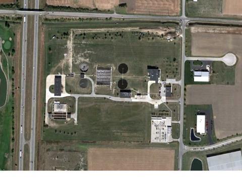
12 2. Using a County Level GIS Database: AREIS On-line (Auditor s Real Estate Information System for Lucas County, Ohio) Access: Enter address of School: 2400 Collingwood Blvd. Zoom in or out to desired view. Select Map Contents from menu above map. Choose year from Layers and Layers Transparency (turn off and on year of choice). Example of 2014 Map from AREIS Online, which includes images dating back to
Looking at Communities: Comparing Urban and Rural Neighborhoods
 Looking at Communities: Comparing Urban and Rural Neighborhoods OVERVIEW & OBJECTIVES Our urban areas have become so dominant that frequently the children we teach have no connection with and very few
Alliance Created State Giant Traveling Map Lesson
 Title: Comparing Arizona s Temperatures Recommended Grades: 4 th 5 th Time Needed: 30 minutes Objectives: Students will: Compare and contrast the geographic features of Arizona by researching seasonal
Minnesota K-12 Academic Standards in Social Studies. Grade 4: Geography of North America
 Minnesota K-12 Academic s in Social Studies Grade 4: Geography of North America 4 Describe how people take 1. Democratic government action to influence a depends on informed and decision on a specific
Module 4 Educator s Guide Overview
 Module 4 Educator s Guide Overview Paths Module Overview This module looks at many different kinds of paths and considers why paths are where they are and how they look from space. Paths are usually not
Your web browser (Safari 7) is out of date. For more security, comfort and. the best experience on this site: Update your browser Ignore
 is out of date. For more security, comfort and. the best experience on this site: Update your browser Ignore") Your web browser (Safari 7) is out of date. For more security, comfort and Activityengage the best experience on this site: Update your browser Ignore Comparing Historical Maps How can historical maps
Your web browser (Safari 7) is out of date. For more security, comfort and Activityengage the best experience on this site: Update your browser Ignore Comparing Historical Maps How can historical maps
My Map Activity MINNESOTA SOCIAL STUDIES STANDARDS & BENCHMARKS
 My Map Activity OVERVIEW & OBJECTIVES Students will learn the basics of Google Maps while using geospatial data to create their neighborhood map with the places they spend time. They will also collect
Lesson Plan 2 - Middle and High School Land Use and Land Cover Introduction. Understanding Land Use and Land Cover using Google Earth
 Understanding Land Use and Land Cover using Google Earth Image an image is a representation of reality. It can be a sketch, a painting, a photograph, or some other graphic representation such as satellite
Geography General Course Year 12. Selected Unit 3 syllabus content for the. Externally set task 2019
 Geography General Course Year 12 Selected Unit 3 syllabus content for the Externally set task 2019 This document is an extract from the Geography General Course Year 12 syllabus, featuring all of the content
Techniques for Science Teachers: Using GIS in Science Classrooms.
 Techniques for Science Teachers: Using GIS in Science Classrooms. After ESRI, 2008 GIS A Geographic Information System A collection of computer hardware, software, and geographic data used together for
A Street Named for a King
 A Street Named for a King Dr. Jerry Mitchell University of South Carolina OVERVIEW This lesson adapts the work of Dr. Derek Alderman, a geographer who has used the Martin Luther King, Jr. street-naming
Lesson Plan - Middle and High School Land Use and Land Cover Introduction. Understanding Land Use and Land Cover using ArcGIS Online
 Lesson Plan - Middle and High School Land Use and Land Cover Understanding Land Use and Land Cover using ArcGIS Online Image an image is a representation of reality. It can be a sketch, a painting, a photograph,
VIDEO: The World In A Box: Geographic Information Systems
 Geographic Information Systems VIDEO: The World In A Box: Geographic Information Systems Adapted from: The World In A Box: Geographic Information Systems. A Public Television Documentary, Opticus Corporation:
Social Studies Grade 2 - Building a Society
 Social Studies Grade 2 - Building a Society Description The second grade curriculum provides students with a broad view of the political units around them, specifically their town, state, and country.
Many Ways to Name a Place
 Your web browser (Safari 7) is out of date. For more security, comfort and Activityapply the best experience on this site: Update your browser Ignore Many Ways to Name a Place What are the names for the
Factors That Shape Places. Sackville North
 Factors That Shape Places Sackville North Stage 3 Geography As urban Sydney sprawls in all directions, the North West is changing dramatically. This Geographical Inquiry will focus on the connections between
K- 5 Academic Standards in. Social Studies. June 2013
 K- 5 Academic s in Social Studies June 2013 Word Tables of s ONLY This Word version of the 2.17.12 social studies standards (DRAFT for Rulemaking 2.17.12) document contains the standards ONLY; no explanatory
Lesson Plan 3 Google Earth Tutorial on Land Use for Middle and High School
 An Introduction to Land Use and Land Cover This lesson plan builds on the lesson plan on Understanding Land Use and Land Cover Using Google Earth. Please refer to it in terms of definitions on land use
Geography for Life. Course Overview
 Geography for Life Description In Geography for Life students will explore the world around them. Using the six essential elements established by the National Geographic Society students will be able to
Geographical knowledge and understanding scope and sequence: Foundation to Year 10
 Geographical knowledge and understanding scope and sequence: Foundation to Year 10 Foundation Year 1 Year 2 Year 3 Year 4 Year 5 Year 6 Year level focus People live in places Places have distinctive features
ADVANCED PLACEMENT HUMAN GEOGRAPHY
 ADVANCED PLACEMENT HUMAN GEOGRAPHY Unit One Geography: Its Nature and Perspectives Session 3 INTERPRETATION OF PLACES AND PATTERNS PLACE: THE GEOGRAPHIC TERM Place is deceptively complex. Place describes
Factors That Shape Places Sackville North
 Factors That Shape Places Sackville North As urban Sydney sprawls in all directions, the North West is changing dramatically. This Geographical Inquiry will focus on the connections between people and
Switching to AQA from Edexcel: Draft Geography AS and A-level (teaching from September 2016)
") Switching to AQA from Edexcel: Draft Geography AS and A-level (teaching from September 2016) If you are thinking of switching from OCR to AQA (from September 2016), this resource is an easy reference guide.
Switching to AQA from Edexcel: Draft Geography AS and A-level (teaching from September 2016) If you are thinking of switching from OCR to AQA (from September 2016), this resource is an easy reference guide.
Changes in Seasonal Albedo with Land Cover Class
 Name: Date: Changes in Seasonal Albedo with Land Cover Class Guiding question: How does albedo change over the seasons in different land cover classes? Introduction. Now that you have completed the Introduction
Washington State K 12 Learning Standards and Guidelines Science Grade: 6 - Adopted: 2014
 Main Criteria: Washington State K 12 Learning Standards and Guidelines Secondary Criteria: Subjects: Science, Social Studies Grade: 6 Correlation Options: Show Correlated Washington State K 12 Learning
Factors that Shape Places Stage 3 Geography
 Factors that Shape Places Stage 3 Geography Summary This unit is written for Stage 3 "Factors that shape places". It is a Geographical Inquiry, enabling students to work through the 3 stages of inquiry;
Module 3 Educator s Guide Overview
 Module 3 Educator s Guide Overview Human footprints on Earth as seen by NASA scientists Module Overview This module draws upon NASA images and research to introduce students to the various ways humans
Welcome Survey getting to know you Collect & log Supplies received Classroom Rules Curriculum overview. 1 : Aug 810. (3 days) 2nd: Aug (5 days)
 2nd: Aug (5 days)") 1st Quarter (41Days) st 1 : Aug 810 (3 days) 2nd: Aug 13-17 Reporting Categories (TEKS SEs) Skill Create and write a postcard about your favorite community activity Review 2nd Grade Vocabulary Chapter
1st Quarter (41Days) st 1 : Aug 810 (3 days) 2nd: Aug 13-17 Reporting Categories (TEKS SEs) Skill Create and write a postcard about your favorite community activity Review 2nd Grade Vocabulary Chapter
K- 5 Academic Standards in. Social Studies. June 2013
 K- 5 Academic s in Social Studies June 203 Word Tables of s ONLY This Word version of the 2.7.2 social studies standards (DRAFT for Rulemaking 2.7.2) document contains the standards ONLY; no explanatory
Delta RV Eighth Grade Social Studies Revised-2010
 Delta RV Eighth Grade Social Studies Revised-2010 Principles of Constitutional Democracy Content Standard 1: Knowledge of the principles expressed in documents shaping constitutional democracy in the United
North Carolina Essential Standards Kindergarten Social Studies
 North Carolina s Kindergarten Social Studies Kindergarten through second grade students are introduced to an integrative approach of Social Studies by exploring aspects of self, others, families and communities
Washington State K 12 Learning Standards and Guidelines Science Grade: 8 - Adopted: 2014
 Main Criteria: Washington State K 12 Learning Standards and Guidelines Secondary Criteria: Subjects: Science, Social Studies Grade: 8 Correlation Options: Show Correlated Washington State K 12 Learning
Programs Aligned With: Kindergarten Social Studies
 Programs Aligned With: Kindergarten Social Studies Progressive Waste Solutions K.2.1 Compare and contrast children and families today with those in the past using various sources K.3.2 Identify maps and
Geography. Programme of study for key stage 3 and attainment target (This is an extract from The National Curriculum 2007)
") Geography Programme of study for key stage 3 and attainment target (This is an extract from The National Curriculum 2007) Crown copyright 2007 Qualifications and Curriculum Authority 2007 Curriculum aims
Geography Programme of study for key stage 3 and attainment target (This is an extract from The National Curriculum 2007) Crown copyright 2007 Qualifications and Curriculum Authority 2007 Curriculum aims
Factors that Shape Places (Blacktown) Stage 3 Geography
 Stage 3 Geography") Factors that Shape Places (Blacktown) Stage 3 Geography Summary This unit is written for Stage 3 "Factors that shape places". It is a Geographical Inquiry, enabling students to work through the 3 stages
Factors that Shape Places (Blacktown) Stage 3 Geography Summary This unit is written for Stage 3 "Factors that shape places". It is a Geographical Inquiry, enabling students to work through the 3 stages
Awesomeness High School (123) Course Syllabus for Human Geography
 Course Syllabus for Human Geography") Awesomeness High School (123) 456-7890 Social Studies Mock@mnsu.edu Tommy. T. Mock Room #1 Course Description: Course Syllabus for Human Geography Human Geography is a semester long course (18 Weeks) that
Awesomeness High School (123) 456-7890 Social Studies Mock@mnsu.edu Tommy. T. Mock Room #1 Course Description: Course Syllabus for Human Geography Human Geography is a semester long course (18 Weeks) that
Grades K-2 Social Studies GLE Comparison Chart
 Grades K-2 Social Studies GLE Comparison Chart Kindergarten Grade 1 No or Minimal 40% Change 1 10/25 GLEs Moderate 12% Change 2 3/25 GLEs 44% New Content 11/25 GLEs No or Minimal Change Moderate Change
New York State Learning Standards and Core Curriculum Science Grade: 3 - Adopted: Interdependent Relationships in Ecosystems
 Main Criteria: New York State Learning Standards and Core Curriculum Secondary Criteria: Subjects: Science, Social Studies Grade: 3 Correlation Options: Show Correlated New York State Learning Standards
@CrawshawGeog. A Level Geography. Crawshaw Academy
 @CrawshawGeog A Level Geography Crawshaw Academy Why study Geography? Students who choose geography will gain a deeper understanding of how the world works and how the people in it interact. Geography
Lesson Plan 3 Land Cover Changes Over Time. An Introduction to Land Cover Changes over Time
 An Introduction to Land Cover Changes over Time This lesson plan builds on the lesson plan on Understanding Land Use and Land Cover Using Google Earth. Please refer to it in terms of definitions on land
Expanding Canada s Rail Network to Meet the Challenges of the Future
 Expanding Canada s Rail Network to Meet the Challenges of the Future Lesson Overview Rail may become a more popular mode of transportation in the future due to increased population, higher energy costs,
IN Indiana Indiana Academic Standards
 IN Indiana Indiana Academic Standards Indiana Academic Standards for Grade 3 History Students describe how significant people, events and developments have shaped their own community and region; compare
LOUISIANA STUDENT STANDARDS FOR SOCIAL STUDIES THAT CORRELATE WITH A FIELD TRIP TO DESTREHAN PLANTATION KINDERGARTEN
 LOUISIANA STUDENT STANDARDS FOR SOCIAL STUDIES THAT CORRELATE WITH A FIELD TRIP TO DESTREHAN PLANTATION KINDERGARTEN Standard 2 Historical Thinking Skills Students distinguish between events, people, and
Climate Change: How it impacts Canadians and what we can do to slow it down.
 Climate Change: How it impacts Canadians and what we can do to slow it down. Lesson Overview This lesson takes stock of how climate change has already affected Canadians in geographic, economic, and cultural
Your web browser (Safari 7) is out of date. For more security, comfort and. the best experience on this site: Update your browser Ignore
 is out of date. For more security, comfort and. the best experience on this site: Update your browser Ignore") Your web browser (Safari 7) is out of date. For more security, comfort and Activitydevelop the best experience on this site: Update your browser Ignore Places in the Park Why do we use symbols? Overview
Your web browser (Safari 7) is out of date. For more security, comfort and Activitydevelop the best experience on this site: Update your browser Ignore Places in the Park Why do we use symbols? Overview
NSW Education Standards Authority. Geography Geography Life Skills Stage 6 Draft Directions for Syllabus Development
 NSW Education Standards Authority Geography Geography Life Skills Stage 6 Draft Directions for Syllabus Development for Consultation 23 July 2018 2 September 2018 2018 NSW Education Standards Authority
The Blacktown Fishing Bat
 Factors That Shape Places The Blacktown Fishing Bat As urban Sydney sprawls in all directions, the Blacktown Local Government Area is changing dramatically. This Geographical Inquiry will focus on the
Nature s Art Village
 Nature s Art Village Educational Field Trip Programs Guide To: College, Career & Civic Life C3 Framework For Social Studies State Standards Grades 3 through 5 All That Glitters Children journey back in
Alleghany County Schools Curriculum Guide GRADE/COURSE: World Geography
 GRADE/COURSE: World 2013-14 GRADING PERIOD: 1 st Six Weeks Time Frame Unit/SOLs SOL # Strand Resource Assessment 8 days* The student will use maps, globes, satellite images, photographs, or diagrams to
Advanced Placement Human Geography
 Advanced Placement Human Geography Introduction to AP Human Geography The Advanced Placement course in Human Geography is designed to introduce students to the systematic study of the processes that have
Anoka Hennepin K 12 Curriculum Unit Plan
 Anoka Hennepin K 12 Curriculum Unit Plan Department: Social Studies Grade Level: 4 Unit Title: Geographic Investigations Trimester: 2 and 3 (16) 55 minute lessons (can be (32) 25 minute lessons) Unit Summary:
PALS: Neighborhood Identification, City of Frederick, Maryland. David Boston Razia Choudhry Chris Davis Under the supervision of Chao Liu
 PALS: Neighborhood Identification, City of Frederick, Maryland David Boston Razia Choudhry Chris Davis Under the supervision of Chao Liu University of Maryland School of Architecture, Planning & Preservation
TEMPLATE FOR CMaP PROJECT
 TEMPLATE FOR CMaP PROJECT Project Title: Native Utah Plants Created by: Anna Davis Class: Box Elder 2008 Project Description Community Issue or Problem Selected -How project evolved? Community Partner(s)
Seymour Centre 2017 Education Program 2071 CURRICULUM LINKS
 Suitable for: Stage 5 Stage 6 HSC Subject Links: Seymour Centre 2017 Education Program 2071 CURRICULUM LINKS Science Stage Content Objective Outcomes Stage 5 Earth and Space ES3: People use scientific
An Introduction to the South Carolina Atlas
 An Introduction to the South Carolina Atlas Daniel E. Stone Pinewood Preparatory School dstone@pinewoodprep.com Overview This lesson is designed to serve as an introduction to the new South Carolina Atlas.
Geography: Place & Liveability
 Geography: Place & Liveability Learning Area(s) Geography Year(s) 6, 7 Description AC Geography : Year 6 A diverse and connected world takes a global view of geography and focuses particularly on the concepts
NGSS Example Bundles. Page 1 of 13
 High School Modified Domains Model Course III Life Sciences Bundle 4: Life Diversifies Over Time This is the fourth bundle of the High School Domains Model Course III Life Sciences. Each bundle has connections
Geography. Geography A. Curriculum Planner and Skills Mapping Grid GCSE Version 1 October 2012
 Geography GCSE 2012 Geography A Curriculum Planner and Skills Mapping Grid Version 1 October 2012 www.ocr.org.uk/gcse2012 Year 10 Exam work Controlled Assessment Autumn 1 Autumn 2 Spring 1 Spring 2 Summer
Too Close for Comfort
 Too Close for Comfort Overview South Carolina consists of urban, suburban, and rural communities. Students will utilize maps to label and describe the different land use classifications. Connection to
Landmarks Paula Owens 5 7 years
 Landmarks Paula Owens Geography teaching resource 5 7 years This is one of a series of teaching resources for use with Digimap for Schools. For more details about this service, visit http://digimapforschools.edina.ac.uk
Montana Content Standards Science Grade: 6 - Adopted: 2016
 Main Criteria: Montana Content Standards Secondary Criteria: Subjects: Science, Social Studies Grade: 6 Correlation Options: Show Correlated MT.6-8.PS. BENCHMARK / STANDARD 6-8.PS.3. MT.6-8.LS. BENCHMARK
DC Educational Standards Science Grade: 3 - Adopted: From Molecules to Organisms: Structures and Processes
 Main Criteria: DC Educational Standards Secondary Criteria: Subjects: Science, Social Studies Grade: 3 Correlation Options: Show Correlated ESSENTIAL 3-LS1. DC Educational Standards Science Grade: 3 -
EARTH HISTORY SEVENTH GRADE
 Strand 1: Inquiry Process Inquiry Process establishes the basis for students learning in science. Students use scientific processes: questioning, planning and conducting investigations, using appropriate
Northwestern Consolidated Schools of Shelby County. Curriculum. World Studies (Eastern Hemisphere) Prepared by. Rich Ballard
 Prepared by. Rich Ballard") Northwestern Consolidated Schools of Shelby County Curriculum World Studies (Eastern Hemisphere) 7th Grade Prepared by Rich Ballard 2012-2013 1 Triton Central Middle School Vision Statement We are committed
Northwestern Consolidated Schools of Shelby County Curriculum World Studies (Eastern Hemisphere) 7th Grade Prepared by Rich Ballard 2012-2013 1 Triton Central Middle School Vision Statement We are committed
Your web browser (Safari 7) is out of date. For more security, comfort and. the best experience on this site: Update your browser Ignore
 is out of date. For more security, comfort and. the best experience on this site: Update your browser Ignore") Your web browser (Safari 7) is out of date. For more security, comfort and lesson the best experience on this site: Update your browser Ignore Political Borders Why are the borders of countries located
Your web browser (Safari 7) is out of date. For more security, comfort and lesson the best experience on this site: Update your browser Ignore Political Borders Why are the borders of countries located
Labdisc Activity A Walk in the Park
 Labdisc Activity A Walk in the Park Supporting Labdisc Data Logger, GlobiWorld and GlobiLab Software For Elementary School Science A Walk in the Park Introduction We can find green parks in almost every
South Carolina Standards & Learning Science Grade: 2 - Adopted: 2014
 Main Criteria: South Carolina Standards & Learning Secondary Criteria: Subjects: Science, Social Studies Grade: 2 Correlation Options: Show Correlated South Carolina Standards & Learning Science Grade:
SOCIAL STUDIES GRADE 5. I Can Checklist Office of Teaching and Learning Curriculum Division REGIONS AND PEOPLE OF THE WESTERN HEMISPHERE
 SOCIAL STUDIES REGIONS AND PEOPLE OF THE WESTERN HEMISPHERE GRADE 5 I Can Checklist 2015-2016 Aligned with Ohio s Learning Standards for Social Studies Office of Teaching and Learning Curriculum Division
Nebraska Core Academic Content Standards Science Grade: 2 - Adopted: 2010
 Main Criteria: Nebraska Core Academic Content Standards Secondary Criteria: Subjects: Science, Social Studies Grade: 2 Correlation Options: Show Correlated Nebraska Core Academic Content Standards Science
Lesson Title: Then and Now: How Society Alters Topography and Vegetation
 Lesson Title: Then and Now: How Society Alters Topography and Vegetation Lesson Author: Rodney Collins (rwcollins@lf.k12.de.us) Lesson Description: This lesson is a comparative study in which students
State and National Standard Correlations NGS, NCGIA, ESRI, MCHE
 GEOGRAPHIC INFORMATION SYSTEMS (GIS) COURSE DESCRIPTION SS000044 (1 st or 2 nd Sem.) GEOGRAPHIC INFORMATION SYSTEMS (11, 12) ½ Unit Prerequisite: None This course is an introduction to Geographic Information
Hudson River Estuary Climate Change Lesson Project. Grades 5-8 Teacher s Packet. Lesson 2. Observing Changes at Mohonk Preserve
 Grades 5-8 Teacher s Packet Lesson 2 Observing Changes at Mohonk Preserve 2 Observing Changes at Mohonk Preserve NYS Intermediate Level Science Standard 1: Analysis, Inquiry and Design/Scientific Inquiry
WS/FCS Unit Planning Organizer
 WS/FCS Unit Planning Organizer Subject(s) Social Studies Conceptual Lenses Grade/Course 3rd Place Unit of Study Five Themes of Geography Location Unit Title Pacing Geo Explorers 20-22 days Human environment
Grade 3 Social Studies
 Grade 3 Social Studies Social Studies Grade(s) 3rd Course Overview This course focuses on the five Wisconsin Model Academic standards for Social Studies: Geography, History, Political Science and Citizenship,
The Local Community and Regional Communities
 GRADE 3 The Local Community and Regional Communities Subject/Course 0470 Level 3 Through active learning experiences, third grade students gain knowledge and process information about their local community
Career and College Readiness in Terms of Next Generation Science Standards (NGSS)
") Career and College Readiness in Terms of Next Generation Science Standards (NGSS) Michigan An NGSS Lead State Partner Next Generation Science Standards for Today s Students and Tomorrow s Workforce Building
Career and College Readiness in Terms of Next Generation Science Standards (NGSS) Michigan An NGSS Lead State Partner Next Generation Science Standards for Today s Students and Tomorrow s Workforce Building
Third Grade Math and Science DBQ Weather and Climate/Representing and Interpreting Charts and Data - Teacher s Guide
 Third Grade Math and Science DBQ Weather and Climate/Representing and Interpreting Charts and Data - Teacher s Guide A document based question (DBQ) is an authentic assessment where students interact with
Course Title: Social Studies People We Know Grade: 2
 Course Title: People We Know Grade: 2 Credits: 1.0 Lessons per week: 2/3 (total 36 weeks) Subject Philosophy: Course Summary: is a vehicle for examining and developing our own biblical worldview and exploring
Oregon Academic Content Standards Science Grade: 6 - Adopted: From Molecules to Organisms: Structures and Processes
 Main Criteria: Oregon Academic Content Standards Secondary Criteria: Subjects: Science, Social Studies Grade: 6 Correlation Options: Show Correlated OR.MS-LS1. Oregon Academic Content Standards Science
Geography (GEOG) Courses
 Courses") Geography (GEOG) 1 Geography (GEOG) Courses GEOG 100. Introduction to Human Geography. 4 (GE=D4) Introduction to the global patterns and dynamics of such human activities as population growth and movements,
Geography (GEOG) 1 Geography (GEOG) Courses GEOG 100. Introduction to Human Geography. 4 (GE=D4) Introduction to the global patterns and dynamics of such human activities as population growth and movements,
Sample assessment task. Task details. Content description. Year level 7
 Sample assessment task Year level 7 Learning area Subject Title of task Task details Description of task Type of assessment Purpose of assessment Assessment strategy Evidence to be collected Suggested
STAGE 2 GEOGRAPHY: Natural environments
 STAGE 2 GEOGRAPHY: Natural environments Focus area: The Earth s environment Different environments Significance of environments Key inquiry questions How does the environment support the lives of people
Kindergarten: Foundations of Social Studies
 4. Governmental Institutions and Political Processes 1. Citizenship and Government 2. Civic Values and Principles of Democracy 1.Civic Skills indergarten: Foundations of Social Studies In kindergarten,
Changing Communities: Regions of the United States. Social Studies Fairfield Public Schools
 4 Changing Communities: Regions of the United States Social Studies Fairfield Public Schools 4 Grade 4-Communities Across The United States (9/08/2015) DRAFT Description: In Grade 4, students engage in
A new type of RICEPOTS
 A new type of RICEPOTS Alan Parkinson Geography teaching resource College Crown Copyright and Database Right 2014. Ordnance Survey (Digimap Licence) This is one of a series of teaching resources for use
A Correlation of. To the. Idaho Content Standards Social Studies Grade 2
 A Correlation of To the Social Studies Grade 2 A Correlation of myworld Grade 2 Standard 1: History Goal 1.1: Build an understanding of the cultural and social development of the United States. 2.SS.1.1.1
Grade 5: Social Studies Practices
 Grade 5: Social Studies Practices A. Gathering and Using Evidence 1. Develop questions to help identify evidence about topics related to the historical events occurring in the Western Hemisphere that can
GEOGRAPHY (GE) Courses of Instruction
 Courses of Instruction") GEOGRAPHY (GE) GE 102. (3) World Regional Geography. The geographic method of inquiry is used to examine, describe, explain, and analyze the human and physical environments of the major regions of the
GEOGRAPHY (GE) GE 102. (3) World Regional Geography. The geographic method of inquiry is used to examine, describe, explain, and analyze the human and physical environments of the major regions of the
Module 2 Educator s Guide Investigation 2
 Module 2 Educator s Guide Investigation 2 How does remote sensing help us to observe human activities on Earth? Investigation Overview Landscapes that are influenced by human activities are found nearly
K- 5 Academic Standards in. Social Studies. June 2013
 - 5 Academic s in Social Studies June 2013 Word Tables of s ONLY This Word version of the 2.17.12 social studies standards (DRAFT for Rulemaking 2.17.12) document contains the standards ONLY; no explanatory
Next Generation Science Standards Correlations (1 of 6)
") Next Generation Science Standards Correlations (1 of 6) The Next Generation Science Standards (NGSS) were completed and published online (http://www.nextgenscience.org) in April 2013. The standards are
Next Generation Science Standards Correlations (1 of 6) The Next Generation Science Standards (NGSS) were completed and published online (http://www.nextgenscience.org) in April 2013. The standards are
Indiana Academic Standards Science Grade: 3 - Adopted: 2016
 Main Criteria: Indiana Academic Standards Secondary Criteria: Subjects: Science, Social Studies Grade: 3 Correlation Options: Show Correlated Indiana Academic Standards Science Grade: 3 - Adopted: 2016
Spotlight on Population Resources for Geography Teachers. Pat Beeson, Education Services, Australian Bureau of Statistics
 Spotlight on Population Resources for Geography Teachers Pat Beeson, Education Services, Australian Bureau of Statistics Population Population size Distribution Age Structure Ethnic composition Gender
Shaping Your Neighbourhood
 Shaping Your Neighbourhood Building a Core Sustainable Neighbourhood Action Plan Nov. 25 & 26, 2006 Welcome! Peter Russell Planner, Holland Barrs Planning Group Inc. Role in this project: Work with the
SOCIAL STUDIES GRADE 6. I Can Checklist REGIONS AND PEOPLE OF THE EASTERN HEMISPHERE. Office of Teaching and Learning Curriculum Division
 SOCIAL STUDIES REGIONS AND PEOPLE OF THE EASTERN HEMISPHERE GRADE 6 I Can Checklist 2018-2019 Aligned with Ohio s Learning Standards for Social Studies Office of Teaching and Learning Curriculum Division
Louisiana Academic Standards Science Grade: 9 - Adopted: 2017
 Main Criteria: Louisiana Academic Standards Secondary Criteria: Subjects: Science, Social Studies Grade: 9 Correlation Options: Show Correlated Louisiana Academic Standards Science Grade: 9 - Adopted:
GIS = Geographic Information Systems;
 What is GIS GIS = Geographic Information Systems; What Information are we talking about? Information about anything that has a place (e.g. locations of features, address of people) on Earth s surface,
GRADE 5 SOCIAL STUDIES SOCIAL STUDIES APPLICATION. SOCIAL STUDIES STANDARDS for Grade 5
 GRADE 5 SOCIAL STUDIES The Archdiocese of Cincinnati has established the following Social Studies standards based on the most current teachings which are aligned to Ohio New Learning Social Studies Standards.
Week 8 Cookbook: Review and Reflection
 : Review and Reflection Week 8 Overview 8.1) Review and Reflection 8.2) Making Intelligent Maps: The map sheet as a blank canvas 8.3) Making Intelligent Maps: Base layers and analysis layers 8.4) ArcGIS
Bengt Kjellson Chair of the Executive Committee UN-GGIM: Europe. 2 nd Joint UN-GGIM: Europe ESS Meeting 11 th March 2016, Luxembourg
 Bengt Kjellson Chair of the Executive Committee UN-GGIM: Europe 2 nd Joint UN-GGIM: Europe ESS Meeting 11 th March 2016, Luxembourg A global geospatial mandate At its 47th plenary in July 2011, ECOSOC,