Lesson Title: Then and Now: How Society Alters Topography and Vegetation
|
|
|
- Judith Dixon
- 5 years ago
- Views:
Transcription
1 Lesson Title: Then and Now: How Society Alters Topography and Vegetation Lesson Author: Rodney Collins Lesson Description: This lesson is a comparative study in which students construct theories regarding influences of land use decisions. Historical and modern aerial and surface photography is the vehicle by which comparison will be made. Students will apply knowledge of land use in their local community to the content of this lesson in order to encourage student ownership in the lesson. Grade Level: 4-5 End of Cluster Expectations (Benchmarks): Students will apply knowledge of topography, climate, soils, and vegetation of Delaware and the United States to understand how human society alters, and is affected by, the physical environment. Essential Question: What might be the results or impacts of human activities that alter or change the physical environment? Assessments: Two DSTP-type assessment items (one constructed response and one multiple choice) are included on the attached Assessment sheet. Focus Questions: 1. What changes to the physical environment can be noted in the comparison of historic and modern aerial and surface photographs of various locations? 2. What observations and predictions can be made concerning the impact of these changes on society and the physical environment over time? Objective(s): Students will: 1. Compare historic and modern aerial and surface photographs to determine what factors influenced land use decisions. 2. Evaluate the impact of different land uses in various physical environments. 3. Consider future changes in land use and their effects on society. Link to Additional Standards: Geography 1 (Uses of Maps); History 1 (Chronology) Prior Knowledge and Skills: Students should enter this lesson with a firm grasp of map reading. A basic knowledge of identifying map landmarks in small scale is also important, as students will compare changes in topography and vegetation over time. Students should have a working knowledge of how their local community s physical environment has changed within the last three years. Time to Complete: Three to four 45-minute class periods Materials/Resources Needed: List of geography terms and definitions used in this lesson Handout 1 How My Community s Physical Environment Has Changed Computer with internet access for each student or pair of students 1
2 Handout 2 How Society Has Altered the Physical Environment Notebook paper Visuals 1a, 1b, 2 Handout 3 Comparing Coventry and Lexington Assessment Items 1 and 2 Please Note: This lesson may be facilitated by the classroom teacher if the aforementioned materials are reproduced as transparencies and shared with the entire class. Procedural Steps: 1. Introduce or review the list of geography terms and definitions that pertain to Geography Standard Allow students to view several examples of topographical maps. This will reinforce the terms and definitions mentioned in step 1, and it will also help students to visualize possible topography in forthcoming activities within the whole of this lesson. 3. Initiate a class discussion concerning physical changes in the class s local community. The discussion may include such topics as clearing of wooded land,new building construction, land which was previously used for farming, newly established housing developments, and new roadways, railways, or waterways. Students may also mention changes in roadway patterns, roadway expansion, or new bridges. 4. Students will work in pairs to complete Handout 1 How My Community s Physical Environment Has Changed. Once ample time has been given for most of the students to complete the handout, openly discuss the information that was recorded by students. 5. Assign students individually or in pairs to work at computers with internet access. Two websites (listed on Handout 2) will be visited which contain various historic and modern aerial and surface photographs. Students will compare each location s historic and modern photos in order to denote changes to the physical environment by society over time. While visiting each website, each student will complete Handout 2 How Society Has Altered the Physical Environment. 6. Guide students to verbally share noticeable changes for each location visited on the internet. Discuss the following questions with the entire class: 1. Did you see any changes that are similar to those we discovered in our own community? 2. Do you think the changes have improved the communities we have visited, including our own? 3. Have the changes in topography and vegetation harmed the environment in the communities we have visited, including our own? 4. Could anything have been done to allow change while also preserving topography and vegetation in the communities we have visited, including our own? 7. Students will work in pairs to compare changes in topography and vegetation for both Coventry and Lexington using Handout 3 Comparing Coventry and Lexington. 8. Have students make generalizations concerning changes in topography and vegetation in their local community and the communities visited on the internet. Possible responses could include: 1. As the population increased in an area, the topography was changed, such as the addition of new roads to accommodate an increase in traffic. 2
3 2. As the population increased in an area, farmland was used to supply society with housing. 3. Land was used for commercial sites such as shopping malls or strip malls. 4. Road patterns were changed. 5. Old buildings were replaced with new buildings. 9. Administer Assessment Items 1 and 2. Students will work individually to complete the assessment pieces. Extension of Lesson or Concepts: 1. Plan a classroom visit by the city manager of the school s local community to explain how the city or town council makes decisions regarding land use. 2. Contact the Department of Natural Resources (DNREC) to obtain information regarding land use restrictions and the preservation of topography and vegetation. Tips for the Teacher: 1. Review the geography terms and definitions as often as is necessary. For students in fourth grade, many of the terms may be unfamiliar and/or new. 2. Be sure to emphasize the importance of identifying markers such as road bends, waterways, and coastlines when comparing historic and modern aerial photos. This idea also applies to surface photos. Buildings and roadways make good markers in such photos. Citations for Graphics, Information, Adapted Lessons, Etc.:
4 Handout 1 Name: Date: How My Community s Physical Environment Has Changed 1. Identify several places in our local community that have been altered by society. 2. Circle the name of the place in part 1 that you think has been altered most by society. On the lines below, write the changes that have been made to the location s topography and/or vegetation. Changes in Topography: Changes in Vegetation: 3. Write two reasons why you think society has altered the topography and/or vegetation of the location. Reason 1: Reason 2: Handout 2 4
5 Name: Date: How Society Has Altered the Physical Environment View each of the following websites: While viewing each of the sites, answer the following questions on a separate sheet of paper. 1. What were the major changes in topography and vegetation? 2. What types of topography and vegetation were lost or removed? Why do you think these changes were made? 3. What changes may have occurred in transportation routes? 4. What are the positive and negative effects that may have occurred because of changes in the topography and vegetation? 5
6 Handout 3 My Name: My Partner s Name: Comparing Coventry and Lexington Complete the T-chart to record information concerning how the physical environment has been changed in the photographs from both websites that you have viewed. Coventry Lexington 6

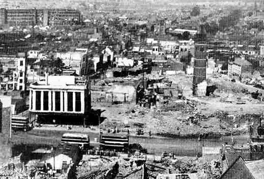
7 Visual 1a


8 Coventry ( Visual 1b Coventry (homepage.ntlworld.com/robert.orland.cov/nowandthen/nowandthen.html) 8

9 Visual
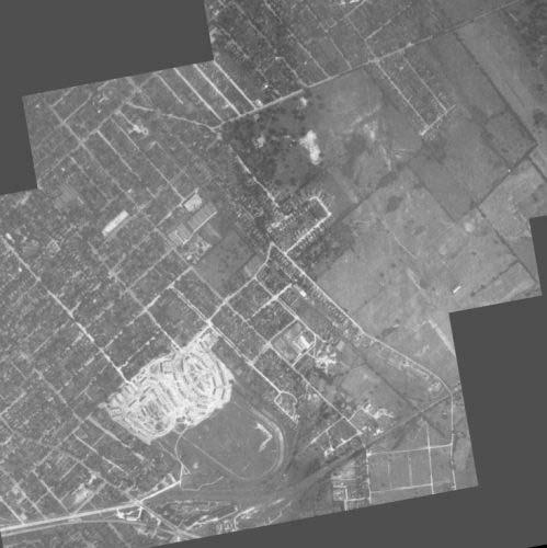
10 Lexington ( Name: Date: Assessment 1 Standard Geo 2 Lesson: Then and Now: How Society Alters Topography and Vegetation Benchmark 4-5 Benchmark Statement: This student work will give evidence of the student s ability to analyze the effects of altering the topography of a physical environment over time by society. Data 1939 aerial photo 1999 aerial photo ( Prompt: Compare the two aerial photographs of Oakledge. How has society altered the topography and vegetation of Oakledge? Predict what a 2059 aerial photograph of Oakledge might look like topographically. Rubric 2 This response gives a valid analysis with an accurate and relevant example. 1 This response gives a valid analysis with an inaccurate, irrelevant or no example. 0 Inaccurate response. 10
11 Name: Date: Assessment 2 Standard Geo 2 Lesson: Then and Now: How Society Alters Topography and Vegetation Benchmark 4-5 Benchmark Statement: This student work will give evidence of the student s ability to analyze the effects of altering the vegetation of a physical environment over time by society. Data 1939 aerial photo 1999 aerial photo ( Prompt: As society continues to inhabit Oakledge and alter its physical environment, which of the following will be true concerning the vegetation in Oakledge? A. Vegetation will not be affected at all in Oakledge. B. The amount of vegetation will decrease in Oakledge. C. A wider variety of vegetation will be found in Oakledge. D. Trees will be the only type of vegetation found in Oakledge. The best response is. Rubric 2 This response gives a valid analysis with an accurate and relevant example. 1 This response gives a valid analysis with an inaccurate, irrelevant or no example. 0 Inaccurate response. 11


12 Assessment Key Standard Geo 2 Lesson: Then and Now: How Society Alters Topography and Vegetation Benchmark 4-5 Benchmark Statement: This student work will give evidence of the student s ability to analyze the effects of altering the vegetation of a physical environment over time by society. Data 1939 aerial photo 1999 aerial photo ( Assessment 1: (Possible Desired Response) The topography of Oakledge has changed in many ways from 1939 to The surface of the land has been leveled to allow a much greater amount of housing for society. Most of the land has become inhabited, so much of the physical environment has been altered. Many new roadways have been added. It looks as though more business or industry has moved into Oakledge. Assessment 2: The correct response is B. 12
13 Geography Terms and Definitions Topography the surface features (rivers, lakes, mountains, hills, canals, bridges, roads, etc.) or the description of physical features of an area Vegetation plant life Society all people; a group of persons regarded as forming a single community Alter to change or modify Physical Environment the natural features and processes of the Earth Location a position or specific place on Earth 13
The maps in this resource can be freely modified and reproduced in the classroom only.
 Teacher's Notes In this activity, students work collaboratively to explore sections of old and new maps. By closely examining these documents, students learn to see maps as more than just tools for locating
Living in a Watershed
 Living in a Watershed Department of Ecosystem Science and Ma... http://ecosystems.psu.edu/youth/sftrc/lesson-plans/water/k-5/watershed Department of Ecosystem Science and Management Youth Living in a Watershed
1. Origins of Geography
 II. ORIGINS AND BRANCHES OF GEOGRAPHY My Notes A. Origins of Geography Unit One 6 Before carefully examining the tools of the geographer, it would be useful to examine the origins and roots of this ancient
Your web browser (Safari 7) is out of date. For more security, comfort and. the best experience on this site: Update your browser Ignore
 is out of date. For more security, comfort and. the best experience on this site: Update your browser Ignore") Your web browser (Safari 7) is out of date. For more security, comfort and Activityengage the best experience on this site: Update your browser Ignore Comparing Historical Maps How can historical maps
Your web browser (Safari 7) is out of date. For more security, comfort and Activityengage the best experience on this site: Update your browser Ignore Comparing Historical Maps How can historical maps
Looking at Communities: Comparing Urban and Rural Neighborhoods
 Looking at Communities: Comparing Urban and Rural Neighborhoods OVERVIEW & OBJECTIVES Our urban areas have become so dominant that frequently the children we teach have no connection with and very few
Module 4 Educator s Guide Overview
 Module 4 Educator s Guide Overview Paths Module Overview This module looks at many different kinds of paths and considers why paths are where they are and how they look from space. Paths are usually not
Module 3 Educator s Guide Overview
 Module 3 Educator s Guide Overview Human footprints on Earth as seen by NASA scientists Module Overview This module draws upon NASA images and research to introduce students to the various ways humans
Landmarks Paula Owens 5 7 years
 Landmarks Paula Owens Geography teaching resource 5 7 years This is one of a series of teaching resources for use with Digimap for Schools. For more details about this service, visit http://digimapforschools.edina.ac.uk
NAME: DATE: Leaving Certificate GEOGRAPHY: Maps and aerial photographs. Maps and Aerial Photographs
 NAME: DATE: Leaving Certificate Geography Maps and Aerial Photographs Please see Teachers Notes for explanations, additional activities, and tips and suggestions. Learning Support Vocabulary, key terms
How Irrigation Affected the Geography of Northeast Oregon
 Delia Wallis How Irrigation Affected the Geography of Northeast Oregon Grade Levels: 4 (with ability to move up or down) Time: two x 45-minute sessions Overview: Students are going to study topographical
My Community vs. Nunavut Weather and Climate
 My Community vs. Nunavut Content Areas Social Studies, Science, Technology Objective Students will differentiate between weather and climate. For 1 month, they will collect and graph daily temperature
Too Close for Comfort
 Too Close for Comfort Overview South Carolina consists of urban, suburban, and rural communities. Students will utilize maps to label and describe the different land use classifications. Connection to
ESSENTIAL QUESTION How can we use the Mars Map and photographs of Mars to learn about the geologic history of the planet?
 GRADE LEVEL(S) 4 6 LENGTH 60 minutes MATERIALS Giant Destination Mars Map Mars Mapping Student Sheet Colored Markers (red, green, blue) VOCABULARY Crater Erode Ejecta Channel Sun Angle Sequence ESSENTIAL
St John s Catholic Primary School. Geography Policy. Mission Statement
 St John s Catholic Primary School Geography Policy Mission Statement We at St John s strive for excellence in education by providing a safe, secure and caring family environment where individuals are valued
Why Do We Live Here? : A Historical Geographical Study of La Tabatiere, Quebec North Shore
 Why Do We Live Here? : A Historical Geographical Study of La Tabatiere, Quebec North Shore Lesson Overview Many communities and their occupants have historical connections to exploration routes and traditional
Minnesota K-12 Academic Standards in Social Studies. Grade 4: Geography of North America
 Minnesota K-12 Academic s in Social Studies Grade 4: Geography of North America 4 Describe how people take 1. Democratic government action to influence a depends on informed and decision on a specific
Canadian Explorers. Learning object La Vérendyre map
 Canadian Explorers Learning object La Vérendyre map Lesson overview Students will be inspired by La Vérendyre to become explorers themselves. Students will embark on a research expedition to discover the
ST AMBROSE CATHOLIC PRIMARY SCHOOL Geography Policy
 ST AMBROSE CATHOLIC PRIMARY SCHOOL Geography Policy 2017-2018 Our school policy is developed in accordance with the National Curriculum for Geography and Foundation Stage Curriculum for Understanding of
Indirect Measurement Technique: Using Trigonometric Ratios Grade Nine
 Ohio Standards Connections Measurement Benchmark D Use proportional reasoning and apply indirect measurement techniques, including right triangle trigonometry and properties of similar triangles, to solve
Thank you for your purchase!
 TM Thank you for your purchase! Please be sure to save a copy of this document to your local computer. This activity is copyrighted by the AIMS Education Foundation. All rights reserved. No part of this
Introduction to Contour Maps
 Your web browser (Safari 7) is out of date. For more security, comfort and Activityengage the best experience on this site: Update your browser Ignore Introduction to Contour Maps What information does
My Map Activity MINNESOTA SOCIAL STUDIES STANDARDS & BENCHMARKS
 My Map Activity OVERVIEW & OBJECTIVES Students will learn the basics of Google Maps while using geospatial data to create their neighborhood map with the places they spend time. They will also collect
St Joseph s R.C. Primary School. Policy for Geography
 St Joseph s R.C. Primary School Policy for Geography 2016-2017 This policy is written with consideration to our school commitment to the Rights of the Child and our achievement of becoming a Rights Respecting
Map and Compass Skills
 Map and Compass Skills Grade levels: 5-12 In a Nutshell Given a map and compass, students will be able to find a location on the map, chart a course to that location with the compass, and find that location
The Blacktown Fishing Bat
 Factors That Shape Places The Blacktown Fishing Bat As urban Sydney sprawls in all directions, the Blacktown Local Government Area is changing dramatically. This Geographical Inquiry will focus on the
Grade Level, Course Third Grade Social Studies PLSD Balanced Assessment Practices. Type* DOK
 Unit Guides Assessment Items Indic ator s Concept Standard Curricular Indicator DOK Type* SR CR PB Assessment Questions # DOK Level 1E 1M 1H 2E 2M 2H 3E 3M 3H Civics Students will develop and apply the
Mapping Earth. How are Earth s surface features measured and modeled?
 Name Mapping Earth How are Earth s surface features measured and modeled? Before You Read Before you read the chapter, think about what you know about maps Record your thoughts in the first column Pair
name and locate the world s seven continents and five oceans
 Subject: Geography Activities National Curriculum Objectives One Progression of Skills Name the 7 continents and 5 oceans 3D Jigsaw task to locate continents and seas name and locate the world s seven
LAKE BILLY CHINOOK by: Steve Fisher. Oregon Geography Content Standards (grade 5):
:") LAKE BILLY CHINOOK by: Steve Fisher OVERVIEW: In this lesson students use historical maps, aerial photographs, personal observation, sketches and oral history to investigate the impact of the damming of
LAKE BILLY CHINOOK by: Steve Fisher OVERVIEW: In this lesson students use historical maps, aerial photographs, personal observation, sketches and oral history to investigate the impact of the damming of
Backward Design Fourth Grade Plant Unit
 Collin Zier Assessment November 2 nd, 2012 Backward Design Fourth Grade Plant Unit Stage One Desired Results Established Goals: Wisconsin s Model Academic Standards for Science 4 th Grade Standard F Life
View Through a Telescope Classroom Activity
 View Through a Telescope Classroom Activity The Classroom Activity introduces students to the context of a performance task, so they are not disadvantaged in demonstrating the skills the task intends to
Beginning Orienteering Post visit
 Beginning Orienteering Post visit Classroom Activities Brief Synopsis The post activities are designed to reinforce what the students learned at Eagle Bluff and practice the skill of map reading. Students
K- 5 Academic Standards in. Social Studies. June 2013
 K- 5 Academic s in Social Studies June 2013 Word Tables of s ONLY This Word version of the 2.17.12 social studies standards (DRAFT for Rulemaking 2.17.12) document contains the standards ONLY; no explanatory
MEADOWS PRIMARY SCHOOL and NURSERY GEOGRAPHY POLICY
 MEADOWS PRIMARY SCHOOL and NURSERY GEOGRAPHY POLICY Purpose of study The teaching of Geography at Meadows is done by following the 2014 National Curriculum. The planning and teaching of the subject aims
Module 2 Educator s Guide Investigation 2
 Module 2 Educator s Guide Investigation 2 How does remote sensing help us to observe human activities on Earth? Investigation Overview Landscapes that are influenced by human activities are found nearly
COMMUNITY SERVICE AREA
 INSTITUTE FOR TRIBAL ENVIRONMENTAL PROFESSIONALS Tribal Waste and Response Assistance Program (TWRAP) Developing and Implementing a Tribal Integrated Solid Waste Management Plan April 12-14, 2016 Palm
Map Makers 2nd Grade
 Map Makers 2nd Grade Students use mapmaking to develop science and social studies concepts and practice map skills while developing a sense of place and a connection to the property. Concepts of landforms,
Mapping Lab Lesson Guide
 Lessons for the Interactive Social Studies Classroom Mapping Lab Lesson Guide Student: Teacher: Room: OHIO MAPPING LAB Preview Making a Mental Map of Ohio Look at the unfinished outline map of Ohio carefully.
Tuition, Medical and Behaviour Support Service
 Tuition, Medical and Behaviour Support Service Curriculum Policy - Primary Geography Reviewed: October 2018 Next Review: October 2019 Responsibility: Andrea Snow AIMS AND PRINCIPLES The national curriculum
Federal Emergency Management Agency, Public Domain.
 Federal Emergency Management Agency, Public Domain. LIMITED LICENSE TO MODIFY. These PowerPoint slides may be modified only by teachers currently teaching the Science and Global Issues SEPUP course to
2275 Speedway, Mail Code C9000 Austin, TX (512) Weather and Climate
 Weather and Climate") Lesson Plan for Grades: Middle School Length of Lesson: 90 minutes Authored by: UT Environmental Science Institute Date created: 05/10/2017 Subject area/course: Mathematics Materials: Fun size bags of
Lesson Plan for Grades: Middle School Length of Lesson: 90 minutes Authored by: UT Environmental Science Institute Date created: 05/10/2017 Subject area/course: Mathematics Materials: Fun size bags of
Factors that Shape Places (Blacktown) Stage 3 Geography
 Stage 3 Geography") Factors that Shape Places (Blacktown) Stage 3 Geography Summary This unit is written for Stage 3 "Factors that shape places". It is a Geographical Inquiry, enabling students to work through the 3 stages
Factors that Shape Places (Blacktown) Stage 3 Geography Summary This unit is written for Stage 3 "Factors that shape places". It is a Geographical Inquiry, enabling students to work through the 3 stages
Anoka Hennepin K 12 Curriculum Unit Plan
 Anoka Hennepin K 12 Curriculum Unit Plan Department: Social Studies Grade Level: 4 Unit Title: Geographic Investigations Trimester: 2 and 3 (16) 55 minute lessons (can be (32) 25 minute lessons) Unit Summary:
Geography Skills Progression Key Stage 2
 Year 3 Year 4 Year 5 Year 6 Expectations at end of key stage Location knowledge the countries of Europe? countries in Europe, environmental regions? countries in Europe, key physical and human characteristics?
Year 1 name and locate the four countries and capital cities of the United Kingdom and its surrounding seas
 Long Term Objective Organisation for Geography Please note that only statutory requirements should be included in this document; any supplementary guidance and information should be retained by Subject
Geography Policy 2014
 Geography Policy 2014 DEFINITION Geography education should inspire in pupils a curiosity and fascination about the world and its people that will remain with them for the rest of their lives. Teaching
Geography Mile Post 1
 Mile Post 1 Use world maps, atlases and globes to identify the UK and its countries, as well as the countries, continents and oceans studied at this key stage Key Skills IPC learning Goals 1.11 Be able
Many Ways to Name a Place
 Your web browser (Safari 7) is out of date. For more security, comfort and Activityapply the best experience on this site: Update your browser Ignore Many Ways to Name a Place What are the names for the
Topographic Maps. Take Notes as you view the slides
 Topographic Maps Take Notes as you view the slides Lesson Objectives Define a topographic map and state its uses. Describe how contour lines show the elevations, shape, and slope of the land. Identify
Topic: Fundamentals of Topographic Map (Cartographic Technique) Honors
 Honors") SN Kansagra School Master lesson Plan : Geography Subject Teacher :- Sanjay Nath Topic: Fundamentals of Topographic Map (Cartographic Technique) Honors Materials (Teaching Aids): White board, Audio visual
SN Kansagra School Master lesson Plan : Geography Subject Teacher :- Sanjay Nath Topic: Fundamentals of Topographic Map (Cartographic Technique) Honors Materials (Teaching Aids): White board, Audio visual
Climate Change: How it impacts Canadians and what we can do to slow it down.
 Climate Change: How it impacts Canadians and what we can do to slow it down. Lesson Overview This lesson takes stock of how climate change has already affected Canadians in geographic, economic, and cultural
Abbotswood Junior School National Curriculum 2014
 Geography Purpose A high-quality geography education should inspire in pupils a curiosity and fascination about the world and its people that will remain with them for the rest of their lives. Teaching
Level 1 Geography, 2016
 91010 910100 1SUPERVISOR S Level 1 Geography, 2016 91010 Apply concepts and basic geographic skills to demonstrate understanding of a given environment 9.30 a.m. Wednesday 16 November 2016 Credits: Four
Recommended Grade Level: 8 Earth/Environmental Science Weather vs. Climate
 Lab Activity Title: Climate Factors Past and Present Recommended Grade Level: 8 Discipline: Earth/Environmental Science Topic: Weather vs. Climate Time Requirements: 90 minutes Submitted by: Karen McCabe
STUDY GUIDE. Exploring Geography. Chapter 1, Section 1. Terms to Know DRAWING FROM EXPERIENCE ORGANIZING YOUR THOUGHTS
 For use with textbook pages 19 22. Exploring Geography Terms to Know location A specific place on the earth (page 20) absolute location The exact spot at which a place is found on the globe (page 20) hemisphere
Geography Policy. for Hertsmere Jewish Primary School
 Geography Policy for Hertsmere Jewish Primary School Reviewed by: L Rubin Reviewed on: September 2017 Date of Next Review: September 2018 Policy Review This policy will be reviewed in full by the Governing
Saskatchewan s Early Trade Routes: The Impact of Geography on Trade
 Saskatchewan s Early Trade Routes: The Impact of Geography on Trade Lesson Overview In this lesson, students will compare and contrast prehistoric First Nations trade routes and trade goods with the routes
GEOGRAPHY POLICY STATEMENT. The study of geography helps our pupils to make sense of the world around them.
 GEOGRAPHY POLICY STATEMENT We believe that the study of geography is concerned with people, place, space and the environment and explores the relationships between the earth and its peoples. The study
Level 1 Geography, 2011
 91010 910100 1SUPERVISOR S Level 1 Geography, 2011 91010 Apply concepts and basic geographic skills to demonstrate understanding of a given environment 9.30 am ednesday Wednesday 2 November 2011 Credits:
a division of Teacher Created Materials
 Sample Pages from a division of Teacher Created Materials Thanks for checking us out. Please call us at 877-777-3450 with questions or feedback, or to order this product. You can also order this product
Techniques for Science Teachers: Using GIS in Science Classrooms.
 Techniques for Science Teachers: Using GIS in Science Classrooms. After ESRI, 2008 GIS A Geographic Information System A collection of computer hardware, software, and geographic data used together for
Kansas Archaeology Month
 Activities for Discovering Prehistoric Trails TIME: 45 min. Kansas Archaeology Month Discovering Prehistoric Trails This lesson is divided into four sections: instructional goals, advanced preparation,
How Geographers View the World: Human Geography. ESSENTIAL QUESTION: How does geography influence the way people live?
 How Geographers View the World: Human Geography ESSENTIAL QUESTION: How does geography influence the way people live? Geographers Think Spatially Gefffffdgfhfjgjp Guiding Question: What does it mean to
Geography Progression
 Geography Progression This document aims to track expectations for History within George Grenville Academy. What the National Curriculum says: KS1: Locational Knowledge: Name and locate the world s 7 continents
Hurricanes A 5 Day Unit Plan. Kristy Scott EDUC 651 October 30, nd grade
 Hurricanes A 5 Day Unit Plan Kristy Scott EDUC 651 October 30, 2006 2 nd grade Unit Overview Unit Description: The focus of this unit is to combine the students experiences of Hurricane Katrina with the
Canadian Mapping Big Book
 Canadian Mapping Big Book Grades 4-6 Written by Lynda Golletz Illustrated by S&S Learning Materials About the Author: Lynda Golletz was an elementary school teacher for thirty-three years. She is the author
Geography. Programmes of study for Key Stages 1-3
 Geography Programmes of study for Key Stages 1-3 February 2013 Contents Purpose of study 3 Aims 3 Attainment targets 3 Subject content 4 Key Stage 1 4 Key Stage 2 5 Key Stage 3 6 2 Purpose of study A high-quality
Course Title: Social Studies People We Know Grade: 2
 Course Title: People We Know Grade: 2 Credits: 1.0 Lessons per week: 2/3 (total 36 weeks) Subject Philosophy: Course Summary: is a vehicle for examining and developing our own biblical worldview and exploring
STAG LANE JUNIOR SCHOOL GEOGRAPHY POLICY
 Status-Recommended Prepared by: Megha Visavadia Date written January 2017 Shared with staff: Spring 2017 STAG LANE JUNIOR SCHOOL GEOGRAPHY POLICY Shared with governors: Spring 2018 Date for review: July
Children needing support to achieve key skills. Children surpassing key skills. Geography Progression in Skills Key Stage One. Locational Knowledge
 Skills Locational Knowledge Geography Progression in Skills Key Stage One Children needing support to achieve key skills Children surpassing key skills To understand that the world extends outside their
Revive, Contemplate, and Integrate Lesson Plan. Your Name: Amanda Pellerin, Amanda Kodeck, and Pat Cruz Grade: 7
 Revive, Contemplate, and Integrate Lesson Plan Your Name: Amanda Pellerin, Amanda Kodeck, and Pat Cruz Grade: 7 Unit of Study: Social Studies/ Visual Arts Lesson Title: Modern Day Maps Goal/Purpose: Students
Progression of skills in Geography
 New Curriculum Holy Trinity CE Primary Academy 2013-14 Subject: Geography Skills: Progression of skills in Geography Geographical enquiry Teacher led enquiries, to ask and respond to simple closed questions.
Geography Policy. Introduction
 Geography Policy Introduction Geography at St. Aloysius Federation School teaches an understanding of places and environments and aims to inspire a curiosity and fascination about the world and its people.
United States of America Geography
 United States of America Geography Part I by Sonja E. Schild LearnSmart Publishing Co. Vancouver, BC, Canada Phone: (604) 433-1347 ISBN 0-9694445-3-9 Notice! All rights reserved. Permission to reproduce
Complete Geography Overview: Year 1 to Year 6
 Option 1 Complete Geography Overview: Year 1 to Year 6 Autumn Term Spring Term Summer Term Year 1 Where do I live? Around the World The Four Seasons Year 2 At the Farm Let s go on Safari My World and Me
WS/FCS Unit Planning Organizer
 WS/FCS Unit Planning Organizer Subject(s) Social Studies Conceptual Lenses Grade/Course 3rd Place Unit of Study Five Themes of Geography Location Unit Title Pacing Geo Explorers 20-22 days Human environment
Alliance Created State Giant Traveling Map Lesson
 Title: Comparing Arizona s Temperatures Recommended Grades: 4 th 5 th Time Needed: 30 minutes Objectives: Students will: Compare and contrast the geographic features of Arizona by researching seasonal
Second Grade Social Studies: Local Communities. Unit 2: Where is My Community and What is it Like There?
 Second Grade Social Studies: Local Communities Unit 2: Big Picture Graphic Overarching Question: How does environment affect a community? Previous Unit: What is a Community? This Unit: Where is My Community
World Geography. Teacher s Guide
 World Geography Teacher s Guide WALCH PUBLISHING Table of Contents To the Teacher.......................................................... vi Classroom Management.................................................
Augusta Canal National Heritage Area 8 Grade Lesson Plans. Stage 1 Desired Results
 Title: Falling into Place Stage 1 Desired Results Subject/Course: Grade: 8th Instructional Time: 10 hrs. Big Ideas: Geographic Regions, The Fall Line and Early Settlements, Rivers and Water Power, The
Factors That Shape Places. Sackville North
 Factors That Shape Places Sackville North Stage 3 Geography As urban Sydney sprawls in all directions, the North West is changing dramatically. This Geographical Inquiry will focus on the connections between
Course Outline. School Name: Keewaytinook Internet High School. Department Name: Canadian and World Studies. Ministry of Education Course Title:
 School Name: Keewaytinook Internet High School Department Name: Canadian and World Studies Course Outline Ministry of Education Course Title: Travel and Tourism: A Geographic Perspective Grade Level: 11
New National Curriculum Geography Skills Planning KS1
 New National Curriculum Geography Skills Planning KS1 Enquiry Question Objective-essential knowledge skills or understanding Locational Knowledge Standards /Success Criteria Lesson progression over half
GEOGRAPHY POLICY. Date: March Signed: Review: March 2019
 GEOGRAPHY POLICY Date: March 2018 Signed: Review: March 2019 Aims At Hayton C of E Primary School we believe that Geography is an essential part of the curriculum and teachers ensure that the children
Pat Taylor Final Project Team Teaching Plan. Lesson Plan 1
 Pat Taylor Final Project Team Teaching Plan Lesson Plan 1 Project Title: Project Description: Features of Michigan Students will illustrate knowledge of Michigan s features by locating and labeling its
Elementary Social Studies Content Area Assessment Task. Winter 2010 EDUC 203
 1 Elementary Social Studies Content Area Assessment Task Winter 2010 EDUC 203 Students: Fourth grade class in Watsonville, CA. Approximately 90% Latino, primarily of Mexicandescent. About 80% participate
Topo Map Tidbits. Adapted from: An original Creek Connections activity. Creek Connections, Box 10, Allegheny College, Meadville, Pennsylvania, 16335
 Topo Map Tidbits Adapted from: An original Creek Connections activity. Creek Connections, Box 10, Allegheny College, Meadville, Pennsylvania, 16335 Introduction to Topographic Maps Grade Level: Basic Duration:
Lesson Topic: Maps of New England
 1 Lesson Topic: Maps of New England Essential Question: How and why have maps of New England changed over time? Grade: 3 Standard/s: Common Core State Standards CCSS.ELA-LITERACY.RI.3.9 Compare and contrast
Sample Pages. Free Newsletter Sign up Today! Learn Through Experience
 Learn Through Experience Sample Pages Sample pages from this product are provided for evaluation purposes. The entire product is available for purchase at www.socialstudies.com or www.teachinteract.com
HOMEWORK CURRICULUM Geography
 HOMEWORK CURRICULUM Geography 2013-2014 Year 7 Term 1 Weather and Climate (will run 2-3 weeks into term 2) Make a mini weather station. Record the weather daily for 3 weeks Write a report on what the data
Walworth Primary School
 Walworth Primary School Date: April 2016 Revision Due: April 2017 Ref: L.Smith Geography Policy 1 Geography Policy Introduction A high quality geography education should inspire in pupils a curiosity and
Level 2 Geography, 2014
 91243 912430 2SUPERVISOR S Level 2 Geography, 2014 91243 Apply geography concepts and skills to demonstrate understanding of a given environment 2.00 pm Monday 10 November 2014 Credits: Four Achievement
Factors that Shape Places Stage 3 Geography
 Factors that Shape Places Stage 3 Geography Summary This unit is written for Stage 3 "Factors that shape places". It is a Geographical Inquiry, enabling students to work through the 3 stages of inquiry;
Lesson #9 Lesson designed by Stefan Superina
 Lesson #9 Lesson designed by Stefan Superina Grades: 6-8 Content Focus: a) Evaluate the relative merits of maps and other geographic representations, tools and technologies in terms of their value in solving
Why Geography Matters
 Why Geography Matters Vocabulary words geography relative location absolute location physical feature human feature region modify adapt cause effect geography: The study of the Earth s physical and human
Geography Curriculum Overview
 Geography Curriculum Overview 2016-2017 Suggest one topic a year for each year group based on another city/country or possible local. Suggested ideas for some year groups have been put in as they will
Factors That Shape Places Sackville North
 Factors That Shape Places Sackville North As urban Sydney sprawls in all directions, the North West is changing dramatically. This Geographical Inquiry will focus on the connections between people and
Programs Aligned With: Kindergarten Social Studies
 Programs Aligned With: Kindergarten Social Studies Progressive Waste Solutions K.2.1 Compare and contrast children and families today with those in the past using various sources K.3.2 Identify maps and
Grade 4 Benchmarks. Benchmark Concepts Skills Essential Question(s)
") **Be aware of the use of and & or in the benchmark language related to Canada and Mexico; sometimes students may look at the US and one of our neighboring countries and other times students need to study
**Be aware of the use of and & or in the benchmark language related to Canada and Mexico; sometimes students may look at the US and one of our neighboring countries and other times students need to study
Geography Long Term Plan
 Geography Long Term Plan Year Group Children should be taught about: The topic this will be based on: Essential Learning Objectives: (Taken from Chris Quigley) Year 1 Name and locate the world s seven