INTRODUCTION TO OGC S SENSORML AND O&M: EXAMPLE OF A POSSIBLE SOLUTION
|
|
|
- Abner Rogers
- 5 years ago
- Views:
Transcription
1 INTRODUCTION TO OGC S SENSORML AND O&M: EXAMPLE OF A POSSIBLE SOLUTION Alessandro Oggioni & Holger Dettki A future for a common bio-logging language? BLS 6, 27 September 2017, Konstanz, Germany

2 OPEN GEOSPATIAL CONSORTIUM (OGC) Standards organization, originated in In the OGC, more than 500 commercial, governmental, nonprofit and research institutions worldwide collaborate in a consensus process encouraging development and implementation of open standards for geospatial content and web services.


 and responses")

3 OPEN GEOSPATIAL CONSORTIUM (OGC) principal OGC web services Web Map Service WMS a standard for exposing spatial data as a images on the web Web Coverage Service WCS a standard for exposing raster data with their informative content on the web Web Feature Service WFS a standard for exposing vector data with their informative content on the web SensorWeb Enablement SOS a standard for exposing observations and sensors information collected by in-situ sensors on the web Web Processing Service WPS a standard for exposing process requests (input) and responses (output) from different data sources Web Catalog Service CSW a standard for exposing a catalogue of geospatial records on the web apr 29-apr 19-mag 8-giu 28-giu 18-lug Q sim Q mis
")

 implementation of SWE services within")
4 OPEN GEOSPATIAL CONSORTIUM (OGC) STANDARDISED SENSOR METADATA - to automatically ingest/import/exchange DATA SENSOR WEB ENABLEMENT (SWE) open geospatial consortium (OGC) and W3C standard SWE = O&M + SensorML capacity of systematic acquisition insitu measurements/observations on-line accessibility to data (O&M) and sensor metadata (SensorML) implementation of SWE services within Spatial Data Infrastructures (SDI)
5 SENSOR METADATA LANGUAGE - SENSORML OGC XML schema for describe instruments: STATIC CONTENT General Info DYNAMIC CONTENT Histories Parameter


 and is not limited to")
6 OBSERVATIONS & MEASUREMENTS (O&M) defines a conceptual schema encoding for observations. While the O&M standard was developed in the context of geographic information systems, the model is derived from generic patterns proposed by Fowler and Odell (1997) and is not limited to spatial information.
7 INTEROPERABILITY: STANDARDS + THESAURUS Contains the actual sensor data Refers to sensor definition SensorML file O&M what is measured? Lookup info for bio-logging terms Web based THESAURUS who measures? what is measured? SENSORML Info about provider, type, setting and data formats for each sensor Refers to Thesaurus file


8 OBSERVATIONS & MEASUREMENTS (O&M) Air Temperature Feature FeatureOfInterest Observation Property h3ps:// edmapache1.umweltbundesam t.at/envthes/usltercv_81 observedproperty Expert judgement procedure Process result Values , , SensorML sensor profile derived from: Katharina Schleidt image within Draft Guidelines for the use of Observations & Measurements and Sensor Web Enablementrelated standards in INSPIRE Annex II and III data specification development. 2013
9 INTEROPERABILITY: STANDARS + THESAURUS SensorML STATIC CONTENT General Info

10 INTEROPERABILITY: STANDARS + THESAURUS SensorML DYNAMIC CONTENT Histories link to other SensorML file

11 INTEROPERABILITY: STANDARS + THESAURUS SensorML DYNAMIC CONTENT Parameter
12 INTEROPERABILITY: STANDARS + THESAURUS O&M link to SensorML file

13 INTEROPERABILITY: STANDARS + THESAURUS O&M

14 INTEROPERABILITY: STANDARS + THESAURUS O&M and SensorML
15 Thesaurus sensorml Observation & Measurements (O&M) SML_Provider_A_Sensor_01_ T100112Z.xml OM_PAS01_ T180336Z.xml OM_PAS01_ T180340Z.xml Thesaurus.xml SML_Provider_A_Sensor_02_ T100112Z.xml OM_PAS02_ T180345Z.xml OM_PAS02_ T180350Z.xml Lookup info for bio- logging terms Web based Info about provider, type, setting and data formats for each sensor Refers to Thesaurus file The file name must be unique to avoid overwriting & reflect setting changes Contains the actual sensor data Refers to sensor definition sensorml file The file name must be unique (ID!) to avoid overwriting
16 Example of GPS data File P1S01_ T180336Z.csv SensorID;DateTime_UTC;ECEF_X;ECEF_Y;ECEF_Z;Lon;Lat;Alt;DOP;FixType;Bat_Main;Bat_Bkup;Temp P1S01; T18:00:43Z; ; ; ; ; ; ;1.8;1;3.28;3.44;16 P1S01; T17:30:13Z; ; ; ; ; ; ;2.6;1;3.28;3.44;15 P1S01; T17:00:12Z; ; ; ; ; ; ;1.6;1;3.36;3.44;14 P1S01; T16:30:13Z; ; ; ; ; ; ;2.0;1;3.36;3.52;14 P1S01; T16:00:42Z; ; ; ; ; ; ;1.6;1;3.28;3.44;14 P1S01; T15:30:12Z; ; ; ; ; ; ;2.8;1;3.28;3.36;15 P1S01; T15:00:13Z; ; ; ; ; ; ;3.0;1;3.28;3.44;15 P1S01; T14:30:13Z; ; ; ; ; ; ;1.4;1;3.28;3.44;15
17 O&M file: Headers <om:om_observation xmlns:sos=" xmlns:swes=" xmlns:swe=" xmlns:sml=" xmlns:gml=" xmlns:xlink=" xmlns:om=" xmlns:sams=" xmlns:sf=" xmlns:xsi=" instance" xsi:schemalocation=" gml:id="o35235"> <gml:name>gps Data</gml:name> <om:type xlink:href=" OM/2.0/OM_SWEObservation"/> <om:phenomenontime> <!- - scts is the time stamp the information was transmitted by , GSM or Iridium - - > <gml:timeinstant gml:id="sctstime_ "> <gml:timeposition> T18:03: :00</gml:timePosition> </gml:timeinstant> </om:phenomenontime>
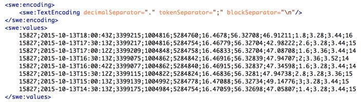
18 O&M file: Data <om:observedproperty xlink:href=" it.it/biologgingsensorml/provider1/sensor01/sml_p1s01_ t100400z.xml"/> <om:result> <swe:dataarray> <swe:encoding> <swe:textencoding decimalseparator="." tokenseparator=";" blockseparator="\n"/> </swe:encoding> <swe:values> P1S01; T18:00:43Z; ; ; ; ; ; ;1.8;1;3.28;3.44;16 P1S01; T17:30:13Z; ; ; ; ; ; ;2.6;1;3.28;3.44;15 P1S01; T17:00:12Z; ; ; ; ; ; ;1.6;1;3.36;3.44;14 P1S01; T16:30:13Z; ; ; ; ; ; ;2.0;1;3.36;3.52;14 P1S01; T16:00:42Z; ; ; ; ; ; ;1.6;1;3.28;3.44;14 P1S01; T15:30:12Z; ; ; ; ; ; ;2.8;1;3.28;3.36;15 P1S01; T15:00:13Z; ; ; ; ; ; ;3.0;1;3.28;3.44;15 P1S01; T14:30:13Z; ; ; ; ; ; ;1.4;1;3.28;3.44;15 </swe:values> </om:result> </swe:dataarray>
19 sensorml file: Definitions File: SML_P1S01_ T100400Z.xml

20 Thesaurus at jpl.nasa.gov

21 sensorml file: Bio- logging Definitions File: SML_P1S01_ T100400Z.xml

22 Bio- logging- Thesaurus at rdfdata.get- it.it it.it/biologgingthesaurus/collartemperature
Borehole Markup Language (BoreholeML, BML)
") Sponsored by Hosted by Borehole Markup Language (BoreholeML, BML) 99th Technical Committee 3D Geoscience borehole ad-hoc meeting Dublin, Ireland - 22 June 2016 Copyright 2016 Open
Sponsored by Hosted by Borehole Markup Language (BoreholeML, BML) 99th Technical Committee 3D Geoscience borehole ad-hoc meeting Dublin, Ireland - 22 June 2016 Copyright 2016 Open
Implementing INSPIRE Geoportal in Turkey
 Implementing INSPIRE Geoportal in Turkey Gencay SERTER City and Regional Planner 1 Presentation Plan Introduction INSPIRE and Turkey Importance of al Spatial Planning Portal Logical&Legal Hierarchy GeoPortal
Dynamizers for CityGML
 Dynamizers for CityGML Kanishk Chaturvedi, Thomas H. Kolbe Chair of Geoinformatics kanishk.chaturvedi@tum.de Time-varying properties Highly dynamic changes Variations of spatial properties: change of a
Portals: Standards in Action
 Portals: Standards in Action David Danko ISO TC 211 Metadata Project Leader GIS Standards Consultant-ESRI. Metadata Portals Portal gateway, place of entry Producers Advertise, expose products Share information
Spatial Data Infrastructure Concepts and Components. Douglas Nebert U.S. Federal Geographic Data Committee Secretariat
 Spatial Data Infrastructure Concepts and Components Douglas Nebert U.S. Federal Geographic Data Committee Secretariat August 2009 What is a Spatial Data Infrastructure (SDI)? The SDI provides a basis for
SDI and Beyond The Importance of Standards and Interoperability For Good Governance; Selected Examples
 SDI and Beyond The Importance of Standards and Interoperability For Good Governance; Selected Examples Trevor Taylor, Director, Member Services, Asia and the Americas Sao Paulo May 7 th, 2014 Why is Geospatial
Roadmap to interoperability of geoinformation
 Roadmap to interoperability of geoinformation and services in Europe Paul Smits, Alessandro Annoni European Commission Joint Research Centre Institute for Environment and Sustainability paul.smits@jrc.it
INSPIREd solutions for Air Quality problems Alexander Kotsev
 INSPIREd solutions for Air Quality problems Alexander Kotsev www.jrc.ec.europa.eu Serving society Stimulating innovation Supporting legislation The European data puzzle The European data puzzle 24 official
INSPIRE General Introduction & Service Architecture
 INSPIRATION Spatial Data Infrastructure in the Western Balkans INSPIRE General Introduction & Service Architecture 1st National INSPIRATION Workshop Croatia November 21-22, 2012 A multi-countryprojectfunded
Overview of Geospatial Open Source Software which is Robust, Feature Rich and Standards Compliant
 Overview of Geospatial Open Source Software which is Robust, Feature Rich and Standards Compliant Cameron SHORTER, Australia Key words: Open Source Geospatial Foundation, OSGeo, Open Standards, Open Geospatial
Think Local - Act Global a Nordic Perspective
 Think Local - Act Global a Nordic Perspective OGC Nordic Forum Jari Reini 20-21.5.2014 OGC Nordic Forum? OGC Nordic Forum addresses OGC outreach and education needs of government, academic, research and
SYNERGY OF SATELLITE REMOTE SENSING AND SENSOR NETWORKS ON GEO GRID
 SYNERGY OF SATELLITE REMOTE SENSING AND SENSOR NETWORKS ON GEO GRID National Institute of Advanced Industrial Science and Technology, Japan Yoshio Tanaka (on behalf of AIST GEO Grid team) Contents Brief
Pushing implementation of European coverage data and services forward
 Pushing implementation of European coverage data and services forward Jordi Escriu jordi.escriu@icgc.cat Head of Unit / IDEC - SDI of Catalonia Facilitator INSPIRE Thematic Cluster #3 Elevation, Orthoimagery,
Modern Education at Universities: Improvements through the Integration of a Spatial Data Infrastructure SDI into an e-learning Environment
 Modern Education at Universities: Improvements through the Integration of a Spatial Data Infrastructure SDI into an e-learning Environment Ingo Simonis Institute for Geoinformatics, University of Muenster
Geotechnology for Agriculture: A view from regulations and free software.
 Geotechnology for Agriculture: A view from regulations and free software. 11 de noviembre del 2015 C O N T E N T S Agriculture, two aspects: data and software Common problems with data and information
Status of interoperability issues in the Chilean SDI. Álvaro Monett Pablo Morales Executive Secretariat NSDI-Chile
 Status of interoperability issues in the Chilean SDI Álvaro Monett Pablo Morales Executive Secretariat NSDI-Chile Outline Background - Chilean SDI working areas Background Interoperability, standards and
Using OGC standards to improve the common
 Using OGC standards to improve the common operational picture Abstract A "Common Operational Picture", or a, is a single identical display of relevant operational information shared by many users. The
NAG-City Expert Workshop Oslo 8-9. October 2012 SOSI standards and mapping for Europe (INSPIRE)
") NAG-City Expert Workshop Oslo 8-9. October 2012 SOSI standards and mapping for Europe (INSPIRE) Per Ryghaug, Geomatics The Norwegian national standard on geographic information - SOSI Started in 1984 NGU
NAG-City Expert Workshop Oslo 8-9. October 2012 SOSI standards and mapping for Europe (INSPIRE) Per Ryghaug, Geomatics The Norwegian national standard on geographic information - SOSI Started in 1984 NGU
Hosted by Esri Official Distributor
 Hosted by Esri Official Distributor Esri European User Conference October 15-17, 2012 Oslo, Norway Hosted by Esri Official Distributor Interoperability and Standards Support in ArcGIS 10.1 Roberto Lucchi
Horizontal Interoperability among National Geoportals of ES, FR, PT & AD
 Horizontal Interoperability among National Geoportals of ES, FR, PT & AD A. F. Rodríguez S. Mas, D. Richard, J. M. Nataf, D. Furtado, R. P. Julião, S. Pijuan, S. Alba 1 Next 15 minutes Intoduction 4 National
OGC and GSDI: A Partnership in Advancing SDI Best Practices
 OGC and GSDI: A Partnership in Advancing SDI Best Practices GSDI 11 Workshop 1.4 SDI Challenges 15 June 2009 Mark Reichardt President and CEO mreichardt@opengeospatial.org +1 301 840-1361 Copyright 2009,
Previous discussion. ECSA Data Tools & Technology WG ENVIP 2015
 Previous discussion ECSA Data Tools & Technology WG ENVIP 2015 Introduction Where we are and were do we want to go? Comparison: Computer Networks and Citizen Science Networks Topics to develop Conceptual
UN-GGIM Arab States Meeting Welcome Address. Denise McKenzie Open Geospatial Consortium 21 February 2017 Doha, Qatar
 UN-GGIM Arab States Meeting Welcome Address Denise McKenzie Open Geospatial Consortium 21 February 2017 Doha, Qatar The Open Geospatial Consortium Not-for-profit, international voluntary consensus standards
Technical Specifications. Form of the standard
 Used by popular acceptance Voluntary Implementation Mandatory Legally enforced Technical Specifications Conventions Guidelines Form of the standard Restrictive Information System Structures Contents Values
ISO INTERNATIONAL STANDARD. Geographic information Metadata Part 2: Extensions for imagery and gridded data
 INTERNATIONAL STANDARD ISO 19115-2 First edition 2009-02-15 Geographic information Metadata Part 2: Extensions for imagery and gridded data Information géographique Métadonnées Partie 2: Extensions pour
SDI Standards at work
 SDI Standards at work Jan Juul Jensen Senior Technology Strategist Informi GIS Denmark Informi GIS Private held Limited Company Specialized in GIS 100+ employees HQ in Charlottenlund, Copenhagen Regional
ISO INTERNATIONAL STANDARD. Geographic information Metadata Part 2: Extensions for imagery and gridded data
 INTERNATIONAL STANDARD ISO 19115-2 First edition 2009-02-15 Geographic information Metadata Part 2: Extensions for imagery and gridded data Information géographique Métadonnées Partie 2: Extensions pour
SITR-IDT The Spatial Data Infrastructure of Sardinia Region
 ITALY LOCAL AUTHORITY FOR MUNICIPALITIES, FINANCES AND URBAN PLANNING REGIONAL DEPARTMENT FOR CARTOGRAPHY AND INFORMATION SYSTEMS SITR-IDT The Spatial Data Infrastructure of Sardinia Region Content of
ISO/TR TECHNICAL REPORT. Geographic information Imagery and gridded data. Information géographique Imagerie et données quadrillées
 TECHNICAL REPORT ISO/TR 19121 First edition 2000-10-15 Geographic information Imagery and gridded data Information géographique Imagerie et données quadrillées Reference number ISO/TR 19121:2000(E) ISO
A Spatial Data Infrastructure for Landslides and Floods in Italy
 V Convegno Nazionale del Gruppo GIT Grottaminarda 14 16 giugno 2010 A Spatial Data Infrastructure for Landslides and Floods in Italy Ivan Marchesini, Vinicio Balducci, Gabriele Tonelli, Mauro Rossi, Fausto
Geological applications using geospatial standards an example from OneGeology-Europe and GeoSciML
 Geological applications using geospatial standards an example from OneGeology-Europe and GeoSciML John Laxton 1, Jean-Jacques Serrano 2, Agnes Tellez-Arenas 2 1 British Geological Survey, Edinburgh, United
March 10 OGC Technical Committee
 March 10 OGC Technical Committee Frascati 99 3 7 99 3 15 99 3 17 1 2010 OGC (Open Geospatial Consortium, Inc.) Technical Committee Frascati 2007 OGC OGC Sensor Web Enablement (SWE) 2.0 Attributes Usage
ArcGIS for INSPIRE. Marten Hogeweg
 ArcGIS for INSPIRE Marten Hogeweg Please Take Our Survey on the App Download the Esri Events app and find your event Select the session you attended Scroll down to find the feedback section Complete answers
WEB MAP SERVICE (WMS) FOR GEOLOGICAL DATA GEORGE TUDOR
 FOR GEOLOGICAL DATA GEORGE TUDOR") WEB MAP SERVICE (WMS) FOR GEOLOGICAL DATA GEORGE TUDOR WEB MAP SERVICE (WMS) - GENERALITIES Projects with data from different sources Geological data are in different GIS software format Large amount of
WEB MAP SERVICE (WMS) FOR GEOLOGICAL DATA GEORGE TUDOR WEB MAP SERVICE (WMS) - GENERALITIES Projects with data from different sources Geological data are in different GIS software format Large amount of
Health DWG ad-hoc. May 31 st, 2013 OGC-TC
 Health DWG ad-hoc May 31 st, 2013 OGC-TC AGENDA 1. Welcome / Roundtable Introductions 2. Background of OGC and proposal of Health DWG 3. Toward an OGC Health DWG 4. Draft Health DWG Charter 5. Potential
Powered by standards new data tools for the climate sciences. Dr Andrew Woolf STFC Rutherford Appleton Lab, UK
 Powered by standards new data tools for the climate sciences Dr Andrew Woolf (Andrew.Woolf@stfc.ac.uk) STFC Rutherford Appleton Lab, UK EGU General Assmebly, Vienna, Splinter Session SPM23, 22-Apr-2009
DGIWG 200. Defence Geospatial Information Framework (DGIF) Overview
 Overview") DGIWG 200 Defence Geospatial Information Framework (DGIF) Overview Document type: Standard Document date: 28 November 2017 Edition: 2.0.0 Responsible Party: Audience: Abstract: Copyright: Defence Geospatial
DGIWG 200 Defence Geospatial Information Framework (DGIF) Overview Document type: Standard Document date: 28 November 2017 Edition: 2.0.0 Responsible Party: Audience: Abstract: Copyright: Defence Geospatial
Conception and Implementation of an OGC-compliant Sensor Observation Service for a Standardized Access to Raster Data
 Conception and Implementation of an OGC-compliant Sensor Observation Service for a Standardized Access to Raster Data Juergen Sorg and Ralf Kunkel Research Center Juelich - Institute of Bio- and Geosciences
INTEGRATING DYNAMIC DATA AND SENSORS WITH SEMANTIC 3D CITY MODELS IN THE CONTEXT OF SMART CITIES
 INTEGRATING DYNAMIC DATA AND SENSORS WITH SEMANTIC 3D CITY MODELS IN THE CONTEXT OF SMART CITIES K. Chaturvedi a, T. H. Kolbe a a Technische Universität München, Chair of Geoinformatics, 80333 Munich,
Mark E Reichardt. President & CEO Open Geospatial Consortium
 Mark E Reichardt President & CEO Open Geospatial Consortium mreichardt@myogc.org Agenda 0900-0915 Welcome and Introduction - Topic setting (Chair) 0915-0935 Ron Bloksma, The next step is interoperability
Urban Planning in the Czech Republic & Humboldt project Otakar ČERBA, Karel CHARVÁT, Štěpán KAFKA
 (Ing. Et Mgr. Otakar ČERBA, Department of Mathematics, Faculty of Applied Sciences, University of West Bohemia in Pilsen, Univerzitní 22, 306 14 Plzen, Czech Republic, ota.cerba@seznam.cz) (RNDr. Karel
From the Venice Lagoon Atlas towards a collaborative federated system
 From the Venice Lagoon Atlas towards a collaborative federated system City of Venice Alessandro Mulazzani CORILA Consortium for Coordination of Research Activities Concerning the Venice Lagoon System ISMAR-CNR
Technical Framework Methodology as a core of building up the NSDI NSDI Implementation Specifics in Serbia
 Technical Framework Methodology as a core of building up the NSDI NSDI Implementation Specifics in Serbia Luka Jovičić SDI Consultant@ Gramont Ltd. Aleksandar Dedić RGA NSDI department Dragica Pajić RGA
Charter for the. Information Transfer and Services Architecture Focus Group
 for the Information Transfer and Services Architecture Focus Group 1. PURPOSE 1.1. The purpose of this charter is to establish the Information Transfer and Services Architecture Focus Group (ITSAFG) as
Visualizing Uncertainty In Environmental Work-flows And Sensor Streams
 Visualizing Uncertainty In Environmental Work-flows And Sensor Streams Karthikeyan Bollu Ganesh and Patrick Maué Institute for Geoinformatics (IFGI), University of Muenster, D-48151 Muenster, Germany {karthikeyan,pajoma}@uni-muenster.de
a national geological survey perspective François ROBIDA BRGM (French Geological Survey)
") a national geological survey perspective François ROBIDA BRGM (French Geological Survey) Pre-Conference Seminar on Socio-Economic Value of Geospatial for National and Regional Development 21 August 2017,
a national geological survey perspective François ROBIDA BRGM (French Geological Survey) Pre-Conference Seminar on Socio-Economic Value of Geospatial for National and Regional Development 21 August 2017,
A Model of GIS Interoperability Based on JavaRMI
 A Model of GIS Interoperability Based on Java Gao Gang-yi 1 Chen Hai-bo 2 1 Zhejiang University of Finance & Economics, Hangzhou 310018, China 2 College of Computer Science and Technology, Zhejiang UniversityHangzhou
Evaluation and Modelling of a Standard Based Spatial Data Infrastructure for Precision Farming
 Evaluation and Modelling of a Standard Based Spatial Data Infrastructure for Precision Farming Jens Wiebensohn 1, Markus Jackenkroll 2 1 Professorship for Geodesy and Geoinformatics, Faculty of Agricultural
Pushing the Standards Edge: Collaborative Testbeds to Accelerate Standards Development and Implementation
 Pushing the Standards Edge: Collaborative Testbeds to Accelerate Standards Development and Implementation Mark E. Reichardt President mreichardt@opengeospatial.org 31 October 2006 2006 Open Geospatial
THE WASHINGTON COASTAL ATLAS
 THE ICAN COASTAL ATLAS MEDIATOR PROTOTYPE AND CONNECTING THE WASHINGTON COASTAL ATLAS Liz O Dea 1, Yassine Lassoued 2, Tanya Haddad 3, Declan Dunne 2 1 GIS Services Unit, WA State Dept. of Ecology 2 Coastal
Communicating Geospatial Information across Communities and Technologies. Presentation to IHO Marine Spatial Data Infrastructure Forum
 Communicating Geospatial Information across Communities and Technologies Presentation to IHO Marine Spatial Data Infrastructure Forum George Percivall OGC Chief Engineer 4 February 2014 OGC Copyright 2014
ArcGIS for INSPIRE. Marten Hogeweg Satish Sankaran
 ArcGIS for INSPIRE Marten Hogeweg Satish Sankaran Outline What is ArcGIS ArcGIS for INSPIRE Web GIS Case Studies Roadmap Q&A What is INSPIRE? INSPIRE is the legal framework for a European Spatial Data
ESBN. Working Group on INSPIRE
 ESBN Working Group on INSPIRE by Marc Van Liedekerke, Endre Dobos and Paul Smits behalf of the WG members WG participants Marc Van Liedekerke Panos Panagos Borut Vrščaj Ivana Kovacikova Erik Obersteiner
Open Geospatial Consortium Meteorology & Oceanography Domain Working Group Progress
 Open Geospatial Consortium Meteorology & Oceanography Domain Working Group Progress Chris Little, Co-Chair Met Ocean DWG (Marie-Françoise Voidrot, Météo-France, Co-Chair) ECWMF, Reading UK 2013-03-04/06
SITMUN: Cooperating to Build Local SDIs in the Barcelona Region
 SITMUN: Cooperating to Build Local SDIs in the Barcelona Region Diputació de Barcelona Territory and Sustainability Area Territorial Information Systems Department INSPIRE CONFERENCE Barcelona, September
Open Geospatial Consortium Meteorology and Oceanography Domain Working Group progress report
 Open Geospatial Consortium Meteorology and Oceanography Domain Working Group progress report Twelfth Workshop on Meteorological Operational Systems ECMWF November 2009 Marie-Françoise Voidrot-Martinez,
Sharing soil information with the help of INSPIRE, key challenges with soil data management
 Sharing soil information with the help of INSPIRE, key challenges with soil data management Katharina Feiden e-mail: gssoil@portalu.de GS Soil: project outline GS Soil: Assessment and strategic development
GEOSPATIAL WEB SERVICE INTEGRATION AND MASHUPS FOR WATER RESOURCE APPLICATIONS
 GEOSPATIAL WEB SERVICE INTEGRATION AND MASHUPS FOR WATER RESOURCE APPLICATIONS C. Granell a, *, L. Díaz a, M. Gould a a Center for Interactive Visualization, Department of Information Systems, Universitat
2nd Joint SIG 3D and OGC Workshop - CityGML EnergyADE for building energy calculation. Working group metadata
 2nd Joint SIG 3D and OGC Workshop - CityGML EnergyADE for building energy calculation Working group metadata TOC Metadata standards for spatial data CityGML Metadata discussion at SIG3D and OGC Closer
Expressing weather observations as linked data;
 Expressing weather observations as linked data; ISO 19100 geographic information meets semantic web head on Jeremy Tandy Smile for the camera (Earth Observation) / Linking Geospatial Data 5 March 2014
OGC Standards Update 29 November 2018 Orlando
 OGC Standards Update 29 November 2018 Orlando Mark Reichardt mreichardt@opengeospatial.org +1 301 840-1361 OGC S INTEREST It s simple You have this or this and you need to make this... or this Courtesy
gvsig: Open Source Solutions in spatial technologies
 gvsig: Open Source Solutions in spatial technologies gvsig is a tool for handling geographical information, a completely GIS client with license GNU GPL. Alvaro A. Anguix Alfaro, Gabriel Carrión Rico Conselleria
Geospatial Standards Support - An Overview. Marten Hogeweg & Satish Sankaran
 Geospatial Standards Support - An Overview Marten Hogeweg & Satish Sankaran Agenda Interoperability and Standards ArcGIS Open, Interoperable and Standards Compliant Esri Open initiatives Understanding
EXPECTATIONS OF TURKISH ENVIRONMENTAL SECTOR FROM INSPIRE
 EXPECTATIONS OF TURKISH ENVIRONMENTAL SECTOR FROM INSPIRE June, 2010 Ahmet ÇİVİ Tuncay DEMİR INSPIRE in the Eyes of MoEF Handling of Geodata by MoEF Benefits Expected TEIEN First Steps for INSPIRE Final
Benefits of Open Standards how to engage with OGC
 Benefits of Open Standards how to engage with OGC Athina Trakas OGC, Inc. Director Business Development Europe atrakas@opengeospatial.org With support from Mark Reichardt (President & CEO) and Martin Klopfer
Copernicus Big Data Workshop, Brussels, Belgium
 Copernicus Big Data Workshop, Brussels, Belgium 13 th March 2014 Bart De Lathouwer 2013 Open Geospatial Consortium Agenda Geospatial Big Data Open Geospatial Consortium s and Big Data Conclusions 2014
Finding geodata that otherwise would have been forgotten GeoXchange a portal for free geodata
 Finding geodata that otherwise would have been forgotten GeoXchange a portal for free geodata Sven Tschirner and Alexander Zipf University of Applied Sciences FH Mainz Department of Geoinformatics and
INSPIRE - A Legal framework for environmental and land administration data in Europe
 INSPIRE - A Legal framework for environmental and land administration data in Europe Dr. Markus Seifert Bavarian Administration for Surveying and Cadastre Head of the SDI Office Bavaria Delegate of Germany
D.5.1: report on user requirements for the EuroGEOSS Drought operating capacity Revised Version
 Project start date: 01 May 2009 Acronym: EuroGEOSS Project title: EuroGEOSS, a European Theme: FP7-ENV-2008-1: Environment (including climate change) Theme title: ENV.2008.4.1.1.1: European Environment
Spatial data interoperability and INSPIRE compliance the platform approach BAGIS
 Spatial data interoperability and INSPIRE compliance the platform approach BAGIS BAGIS Voluntary, independent, public, non-profit organization; Organization with main mission to promote the growth of the
MONITORING LOGISTICS OPERATIONS OF THE FOREST BASED SUPPLY CHAIN IN (NEAR) REAL-TIME UTILIZING HARMONIZATION APPROACHES: a Case Study from Austria
 REAL-TIME UTILIZING HARMONIZATION APPROACHES: a Case Study from Austria") MONITORING LOGISTICS OPERATIONS OF THE FOREST BASED SUPPLY CHAIN IN (NEAR) REAL-TIME UTILIZING HARMONIZATION APPROACHES: a Case Study from Austria Johannes Scholz 1 Manfred Mittlboeck 2 Ralph Jank 2 1
MONITORING LOGISTICS OPERATIONS OF THE FOREST BASED SUPPLY CHAIN IN (NEAR) REAL-TIME UTILIZING HARMONIZATION APPROACHES: a Case Study from Austria Johannes Scholz 1 Manfred Mittlboeck 2 Ralph Jank 2 1
Paper UC1351. Conference: User Conference Date: 08/10/2006 Time: 8:30am-9:45am Room: Room 23-B (SDCC)
") Conference: User Conference Date: 08/10/2006 Time: 8:30am-9:45am Room: Room 23-B (SDCC) Title of Paper: Increasing the Use of GIS in the Federal Government Author Name: Miss Abstract This presentation
Conference: User Conference Date: 08/10/2006 Time: 8:30am-9:45am Room: Room 23-B (SDCC) Title of Paper: Increasing the Use of GIS in the Federal Government Author Name: Miss Abstract This presentation
Reprint of article that appeared in Hydro INTERNATIONAL November 2006 Volume 10 Issue 9
 Reprint of article that appeared in Hydro INTERNATIONAL November 2006 Volume 10 Issue 9 While Google Earth is the best known 3D web-mapping viewer currently in the public domain, there are alternative
Climate Data for Non-experts: Standards-based Interoperability
 Climate Data for Non-experts: Standards-based Interoperability Ben Domenico Unidata Program Center University Corporation for Atmospheric Research April 2010 Working Together on A Mosaic for Atmospheric
The PREVIEW Global Risk Data Platform: a geoportal to serve and share global data on risk to natural hazards
 The PREVIEW Global Risk Data Platform: a geoportal to serve and share global data on risk to natural hazards Gregory Giuliani (UNEP/GRID-Geneva & University of Geneva/enviroSPACE ) http://www.grid.unep.ch
econtentplus GS Soil
 econtentplus GS Soil General aims Assessment and strategic development of INSPIRE compliant Geodata-Services for European Soil Data BPN on basis of the EU 2007/2/EC (INSPIRE) Directive for Annex III theme
GIS GIS.
 GIS 388 Vol., No.3, Autumn 2009 99-4 GIS Iranian Remote Sensing & GIS 2 * (GIS). GIS.2 389/5/6 : 389/2/6 :........ : 8878622 : GIS ( ) : * Email: PouriaAmirian@gmail.com ... (AQI) 2.(Cheng et al., 2007)..
Open Contextual Cartographic Visualization
 J. Kozel 223 Open Contextual Cartographic Visualization Jiří Kozel Laboratory on Geoinformatics and Cartography, Insitute of Geography, Faculty of Science, Masaryk University, Czech Republic jirikozel@centrum.cz
Harmonisation of Spatial Planning Data
 INSPIRE Conference 18 June 2011 Edinburgh, Great Britain Harmonisation of Spatial Planning Data Tomas Mildorf University of West Bohemia mildorf@centrum.cz Pilsen, Czech Republic Co-funded by the Community
Conceptual Modelling within The OGC MetOcean Domain Working Group
 Conceptual Modelling within The OGC MetOcean Domain Working Group 21 st EGOWS Mtg, 1 st -4 th June 2010, ECMWF Dominic Lowe, dominiclowe@stfc.ac.uk British Atmospheric Data Centre, http://badc.nerc.ac.uk
ISO INTERNATIONAL STANDARD. Geographic information Spatial referencing by coordinates
 INTERNATIONAL STANDARD ISO 19111 Second edition 2007-07-01 Geographic information Spatial referencing by coordinates Information géographique Système de références spatiales par coordonnées Reference number
Building a 4-D Weather Data Cube for the NextGen Initial Operating Capability (IOC)
") Building a 4-D Weather Data Cube for the NextGen Initial Operating Capability (IOC) Friends/Partners in Aviation Weather Vision Forum July 15, 2008 Bruce Lambert - DoD Tom Ryan FAA Jason Tuell NWS 1 Overview
Building a 4-D Weather Data Cube for the NextGen Initial Operating Capability (IOC) Friends/Partners in Aviation Weather Vision Forum July 15, 2008 Bruce Lambert - DoD Tom Ryan FAA Jason Tuell NWS 1 Overview
Geospatial Ontology Trade Study
 Ontology for the Intelligence Community (OIC-2007) November 28-29, 2007 Columbia, Maryland Geospatial Ontology Trade Study James Ressler 1, Mike Dean 2 1 a james.ressler@ngc.com Northrop Grumman Corporation
PaikkaOppi - a Virtual Learning Environment on Geographic Information for Upper Secondary School
 PaikkaOppi - a Virtual Learning Environment on Geographic Information for Upper Secondary School Jaakko Kähkönen*, Lassi Lehto*, Juha Riihelä** * Finnish Geodetic Institute, PO Box 15, FI-02431 Masala,
Project EuroGeoNames (EGN) Results of the econtentplus-funded period *
 Results of the econtentplus-funded period *") UNITED NATIONS Working Paper GROUP OF EXPERTS ON No. 33 GEOGRAPHICAL NAMES Twenty-fifth session Nairobi, 5 12 May 2009 Item 10 of the provisional agenda Activities relating to the Working Group on Toponymic
UNITED NATIONS Working Paper GROUP OF EXPERTS ON No. 33 GEOGRAPHICAL NAMES Twenty-fifth session Nairobi, 5 12 May 2009 Item 10 of the provisional agenda Activities relating to the Working Group on Toponymic
INSPIRE implementation in Portugal: the operational approach
 INSPIRE implementation in Portugal: the operational approach REIS, Rui; SANTOS, Ana Sofia; FONSECA, Alexandra; SILVA, Henrique; GOMES, Ana Luisa; FURTADO, Danilo; GEIRINHAS, João rui.reis@igeo.pt AGENDA
NOKIS - Information Infrastructure for the North and Baltic Sea
 NOKIS - Information Infrastructure for the North and Baltic Sea Carsten Heidmann 1 and Jörn Kohlus 2 Abstract 1. General The initial motivation for the project NOKIS (German title: Nord- und Ostsee-Küsteninformationssystem)
Introduction to geoprocessing services using SEXTANTE. Víctor Olaya SEXTANTE Geospatial Services
 Introduction to geoprocessing services using SEXTANTE. Víctor Olaya SEXTANTE Geospatial Services Overview Quick introduction to SEXTANTE Client/Server fundamentals Standards for web-based geoservices SEXTANTE
Implementing strategy for the Infrastructure for Spatial Information in Europe - INSPIRE Paul Smits
 Implementing strategy for the Infrastructure for Spatial Information in Europe - INSPIRE Paul Smits European Commission DG Joint Research Centre Institute for Environment and Sustainability Ispra, Italy
Semantic Evolution of Geospatial Web Services: Use Cases and Experiments in the Geospatial Semantic Web
 Semantic Evolution of Geospatial Web Services: Use Cases and Experiments in the Geospatial Semantic Web Joshua Lieberman, Todd Pehle, Mike Dean Traverse Technologies, Inc., Northrop Grumman Information
Discovery and Access of Geospatial Resources using the Geoportal Extension. Marten Hogeweg Geoportal Extension Product Manager
 Discovery and Access of Geospatial Resources using the Geoportal Extension Marten Hogeweg Geoportal Extension Product Manager DISCOVERY AND ACCESS USING THE GEOPORTAL EXTENSION Geospatial Data Is Very
SDI in Finland Nordic SDI Seminar Uppsala Panu Muhli
 SDI in Finland Nordic SDI Seminar Uppsala 3.10.2011 Panu Muhli Spatial Data Infrastructure Team Inspire secretariat Development Centre 1 NATIONAL LAND SURVEY DOWN TO EARTH Contents Legal framework Coordination
Key Points Sharing fosters participation and collaboration Metadata has a big role in sharing Sharing is not always easy
 Sharing Resources Geoff Mortson esri, Inc. SDI Solutions Team Key Points Sharing fosters participation and collaboration Metadata has a big role in sharing Sharing is not always easy Data Sharing is Good
Spatially Enabled Society
 International Seminar on Land Administration Trends and Issues in Asia and the Pacific Region Spatially Enabled Society Abbas Rajabifard Vice Chair PCGIAP-WG3 Vice-President (President Elect), GSDI Association
Open Geospatial Consortium 35 Main Street, Suite 5 Wayland, MA Telephone: Facsimile:
 Open Geospatial Consortium 35 Main Street, Suite 5 Wayland, MA 01778 Telephone: +1-508-655-5858 Facsimile: +1-508-655-2237 Editor: Carl Reed Telephone: +1-970-402-0284 creed@opengeospatial.org The OGC
The Baltic Sea Region Maritime Spatial Planning Data Expert Sub-group. First Report 2015/2016/
 The Baltic Sea Region Maritime Spatial Planning Data Expert Sub-group First Report 2015/2016/2017 21.04.2017. Contents 1. Glossary 2 2. Introduction. 3 3. MSP Data. 5 3.1. Input Data. 5 3.2 Output Data.
Towards a European Spatial Data Infrastructure
 Towards a European Spatial Data Infrastructure Paul Smits, Alessandro Annoni, Lars Bernard, Ioannis Kanellopoulos, Michel Millot, Steve Peedell European Commission DG Joint Research Centre Institutefor
Implementation of INSPIRE Principles: Sardinia Region SDI State of the Art and Further Developments
 REGION OF SARDINIA (ITALY) LOCAL AUTHORITY FOR MUNICIPALITIES, FINANCES AND URBAN PLANNING DEPT. FOR THE REGIONAL SPATIAL DATA INFRASTRUCTURE Implementation of INSPIRE Principles: Sardinia Region SDI State
Part 1: Fundamentals
 Provläsningsexemplar / Preview INTERNATIONAL STANDARD ISO 19101-1 First edition 2014-11-15 Geographic information Reference model Part 1: Fundamentals Information géographique Modèle de référence Partie
A Spatial Data Infrastructure dedicated to scientific research and observation of the coastal environment
 A Spatial Data Infrastructure dedicated to scientific research and observation of the coastal environment http://indigeo.fr Mathias ROUAN - Research Engineer - UMR 6554 LETG CNRS Littoral, Environment,