MONITORING LOGISTICS OPERATIONS OF THE FOREST BASED SUPPLY CHAIN IN (NEAR) REAL-TIME UTILIZING HARMONIZATION APPROACHES: a Case Study from Austria
|
|
|
- Priscilla Barrett
- 5 years ago
- Views:
Transcription
1 MONITORING LOGISTICS OPERATIONS OF THE FOREST BASED SUPPLY CHAIN IN (NEAR) REAL-TIME UTILIZING HARMONIZATION APPROACHES: a Case Study from Austria Johannes Scholz 1 Manfred Mittlboeck 2 Ralph Jank 2 1 Graz University of Technology, Institute of Geodesy, RG Geoinformation johannes.scholz@tugraz.at Web: johannesscholz.net 2 Research Studios Austria, Studio ispace, Salzburg, Austria, August 2015
2 Contents Motivation Sensor Data & Spatial-temporal Domain a Standardization issue? Integration of Sensor Data in MBC (Near) Real-Time Sensor Data Collection Conclusion and Future Work 2


3 Motivation Market penetration of Sensors is increasing obvious sensors but also i.e. citizens as sensors (Goodchild 2007) 3


4 Motivation Market penetration of Sensors is increasing Number of proprietary systems and data models handling sensor data and many more! Open Issues: Sharing data between those proprietary systems? Monitoring the status of the forest supply chain in real-time? 4
5 Sensor Data & Spatial-temporal Domain - a Standardization Issue? Due to the high number of different available proprietary systems, data models and sensor data transmission techniques it seems difficult to integrate each part of the FSC in one system. In order to integrate different proprietary systems, we need to think about standardization strategies in order to integrate sensor data right from the start. As the FSC deals with agents that are moving in space and time, any standardization approach needs to take spatial and temporal dimension into account. Integrating sensors involves semantic understanding of the sensors (Bröring et al. 2011a, Bröring et al. 2011b, Janowicz et al. 2010, Kuhn 2009, Kuhn et al. 2014) 5
 Initiative (OGC 2015) with according standards (partly ISO standards): Sensor Observation")
6 Sensor Data & Spatial-temporal Domain - a Standardization Issue? Approach for integrating real-time sensor data: OpenGeospatial Consortium Sensor Web Enablement (SWE) Initiative (OGC 2015) with according standards (partly ISO standards): Sensor Observation Service (SOS) Sensor Model Language (SensorML) Observations and Measurements (ISO 19156) 6
7 7
 8")
8 Sensor Data & Spatial-temporal Domain - a Standardization Issue? McKee (2011) 8
9 Integration of Sensor Data in MBC Model-based Control Overview 9


10 Integration of Sensor Data in MBC Model-based Control Overview Harvesting Standing timber in the forest Forwarding Timber in the forest Transportation Germany/Switzerland Wood piled on roadside Austria Wood reception at the mill 10

")

11 Integration of Sensor Data in MBC Planning Controller Setpoints, constraints Data (Sensors) models Recognize Deviation (now+future) Instructions for operations Suggest or Act within a given threshold Alarm out of a given threshold 11
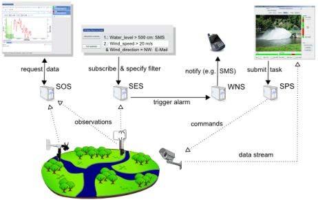
 additional attributive data Data collection employing the Sensor Web and standardized OGC Sensor Observation Services (SOS): Collection of (any) measurement data in a standardized way Storage of")
12 (Near) Real-Time Sensor Data Collection Approach In order to collect real time data of Wood Trucks we need the following data: Position Truck engine status of the truck (velocity, RPM, weight..) additional attributive data Data collection employing the Sensor Web and standardized OGC Sensor Observation Services (SOS): Collection of (any) measurement data in a standardized way Storage of sensor data in a harmonized data structure to: Query sensor data Parallel sensor requests Providing of data in a standardized way (WFS, WMS) 12
13 (Near) Real-Time Sensor Data Collection FOCUS platform solution for the pilot case backoffice FOCUS planning Timeoriented planning control FOCUS control On going monitoring FOCUS dashboard (mobile) Locationindependant monitoring platform FOCUS core FOCUS data base operations arena FOCUS sensor ifos, CANbus polterluchs TimeControl 13
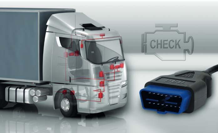
14 (Near) Real-Time Sensor Data Collection Collecting truck position and engine status information Collecting truck position and engine status in near real time Combines vehicle sensor measurements with vehicle location & time using the GNSS of a mobile device Transmit combined measurements in a standardized way to be used by the FOCUS architecture over IP (local app caching supports temporary offline status) Interoperability support OGC SOS Transactional Standard 2.0 Vehicle sensor data collection: Starting Point: Collect sensor data via OBDII/CANbus via Bluetooth (ELM327) WWH OBD (ISO 27145) standard New heavy duty vehicles must conform to the requirements of the Euro VI emissions standard starting in Thus, vehicle manufacturers are obligated to implement a WWH OBD capable diagnostic system Sensors of the mobile device and derived indicators 14


15 (Near) Real-Time Sensor Data Collection Mobile Phone App :: Collecting Data Screenshots of the Android App Connect to OBDII/WWH-OBD Use internal sensors of the mobile phone Send the collected data via IP to the OGC SOS Server live (or stores the data if no Internet connection is available and sends data as bulk message) 15


16 (Near) Real-Time Sensor Data Collection Mobile Phone App :: Collecting Data Screenshots of the Android App Connect to OBDII/WWH-OBD Use internal sensors of the mobile phone Send the collected data via IP to the OGC SOS Server live (or stores the data if no Internet connection is available and sends data as bulk message) 16
17 (Near) Real-Time Sensor Data Collection OGC SOS Service 2.0 with defined semantics The SOS has defined semantics for describing, storing and querying spatio temporal measurements 17


18 (Near) Real-Time Sensor Data Collection OGC SOS Service 2.0 with defined semantics The SOS has defined semantics for describing, storing and querying spatio temporal measurements SOS uses XML encoding for transmitting and and retrieval of sensor data 18

19 (Near) Real-Time Sensor Data Collection Visualization with a GIS Geographic Information Systems (GIS) are tools to visualize, manipulate and manage spatio-temporal data either web-based or desktop-based. OGC Sensor Observation Services can be seamlessly integrated in GIS (desktop and web-based GIS via standardized services) 19
20 Summary & Future Work Monitoring of the FSC actors in near real-time with a sensor cloud in the course of the FOCUS FP7 research project (Advances in Forestry Control and Automation Systems in Europe) Due to the high number of different sensor and system vendors, a multitude of proprietary formats/systems is available which can hardly be linked in real time. Open Geospatial Consortium (and ISO) provides open standards to describe and transmit sensor measurements (with respect to spatial and temporal domain) including open-source reference implementations >> OGC Sensor Web Enablement Initiative To connect with vehicle sensors, standards (OBDII and WWH-OBD) are used which are amended with spatial and temporal data. Vehicle data can be visualized with Geographical Information Systems desktop or webbased both by utilizing standards (OGC SOS, OGC WMS, ). 20
21 Resources Bröring, A., Maué, P., Janowicz, K., Nüst, D., & Malewski, C. (2011a). Semantically-enabled sensor plug & play for the sensor web. Sensors, 11(8), Bröring, A., Echterhoff, J., Jirka, S., Simonis, I., Everding, T., Stasch, C., Liang, S., Lemmens, R. (2011b). New Generation Sensor Web Enablement. Sensors, 11(3), Goodchild, M. F. (2007). Citizens as sensors: the world of volunteered geography. GeoJournal, 69(4), Janowicz, K., Schade, S., Bröring, A., Keßler, C., Maué, P., & Stasch, C. (2010). Semantic enablement for spatial data infrastructures. Transactions in GIS, 14(2), Kuhn, W. (2009). A functional ontology of observation and measurement. In: GeoSpatial Semantics (pp ). Springer Berlin Heidelberg. Kuhn, W., Kauppinen, T., & Janowicz, K. (2014). Linked data-a paradigm shift for geographic information science. In Geographic Information Science (pp ). Springer International Publishing. McKee, L. (2011): Geospatial Standards: Opening up the Geosciences. URL: (last accessed: ). Open Geospatial Consortium (2015). The OGC s Sensor Web Enablement Initiative. URL: (last accessed: ) 21
Semantic Evolution of Geospatial Web Services: Use Cases and Experiments in the Geospatial Semantic Web
 Semantic Evolution of Geospatial Web Services: Use Cases and Experiments in the Geospatial Semantic Web Joshua Lieberman, Todd Pehle, Mike Dean Traverse Technologies, Inc., Northrop Grumman Information
Open Contextual Cartographic Visualization
 J. Kozel 223 Open Contextual Cartographic Visualization Jiří Kozel Laboratory on Geoinformatics and Cartography, Insitute of Geography, Faculty of Science, Masaryk University, Czech Republic jirikozel@centrum.cz
WEB-BASED SPATIAL DECISION SUPPORT: TECHNICAL FOUNDATIONS AND APPLICATIONS
 WEB-BASED SPATIAL DECISION SUPPORT: TECHNICAL FOUNDATIONS AND APPLICATIONS Claus Rinner University of Muenster, Germany Piotr Jankowski San Diego State University, USA Keywords: geographic information
Global 3D Models with Local Content
 Gunnar Misund Associate Professor Head of Environmental Computing gunnar.misund@hiof.no - Morten Granlund, Scientfic Assistant Herman Kolås, Master Student Mats Lindh, Master Student - Østfold University
GIS GIS.
 GIS 388 Vol., No.3, Autumn 2009 99-4 GIS Iranian Remote Sensing & GIS 2 * (GIS). GIS.2 389/5/6 : 389/2/6 :........ : 8878622 : GIS ( ) : * Email: PouriaAmirian@gmail.com ... (AQI) 2.(Cheng et al., 2007)..
Using OGC standards to improve the common
 Using OGC standards to improve the common operational picture Abstract A "Common Operational Picture", or a, is a single identical display of relevant operational information shared by many users. The
Overview. Everywhere. Over everything.
 Cadenza Desktop Cadenza Web Cadenza Mobile Cadenza Overview. Everywhere. Over everything. The ultimate GIS and reporting suite. Provide, analyze and report data efficiently. For desktop, web and mobile.
One platform for desktop, web and mobile
 One platform for desktop, web and mobile Search and filter Get access to all data thematically filter data in context factually and spatially as well as display it dynamically. Export a selection or send
Hosted by Esri Official Distributor
 Hosted by Esri Official Distributor Esri European User Conference October 15-17, 2012 Oslo, Norway Hosted by Esri Official Distributor Interoperability and Standards Support in ArcGIS 10.1 Roberto Lucchi
A Model of GIS Interoperability Based on JavaRMI
 A Model of GIS Interoperability Based on Java Gao Gang-yi 1 Chen Hai-bo 2 1 Zhejiang University of Finance & Economics, Hangzhou 310018, China 2 College of Computer Science and Technology, Zhejiang UniversityHangzhou
Framework for on an open 3D urban analysis platform based on OGC Web Services
 Platzhalter für Bild, Bild auf Titelfolie hinter das Logo einsetzen Framework for on an open 3D urban analysis platform based on OGC Web Services Marc-O. Löwner & Thomas Adolphi (née Becker) Technische
Overview of Geospatial Open Source Software which is Robust, Feature Rich and Standards Compliant
 Overview of Geospatial Open Source Software which is Robust, Feature Rich and Standards Compliant Cameron SHORTER, Australia Key words: Open Source Geospatial Foundation, OSGeo, Open Standards, Open Geospatial
A General Framework for Conflation
 A General Framework for Conflation Benjamin Adams, Linna Li, Martin Raubal, Michael F. Goodchild University of California, Santa Barbara, CA, USA Email: badams@cs.ucsb.edu, linna@geog.ucsb.edu, raubal@geog.ucsb.edu,
Roadmap to interoperability of geoinformation
 Roadmap to interoperability of geoinformation and services in Europe Paul Smits, Alessandro Annoni European Commission Joint Research Centre Institute for Environment and Sustainability paul.smits@jrc.it
Innovation in Land Management: Integrated Solutions For National Cadastre Projects
 Success With GIS Innovation in Land Management: Integrated Solutions For National Cadastre Projects XXIII International FIG Congress Munich These documents are only complete, when used in connection with
Lesson 16: Technology Trends and Research
 http://www.esri.com/library/whitepapers/pdfs/integrated-geoenabled-soa.pdf GEOG DL582 : GIS Data Management Lesson 16: Technology Trends and Research Overview Learning Objective Questions: 1. Why is integration
Mark E Reichardt. President & CEO Open Geospatial Consortium
 Mark E Reichardt President & CEO Open Geospatial Consortium mreichardt@myogc.org Agenda 0900-0915 Welcome and Introduction - Topic setting (Chair) 0915-0935 Ron Bloksma, The next step is interoperability
PaikkaOppi - a Virtual Learning Environment on Geographic Information for Upper Secondary School
 PaikkaOppi - a Virtual Learning Environment on Geographic Information for Upper Secondary School Jaakko Kähkönen*, Lassi Lehto*, Juha Riihelä** * Finnish Geodetic Institute, PO Box 15, FI-02431 Masala,
The INSPIRE Community Geoportal
 Infrastructure for Spatial Information in the European Community The INSPIRE Community Geoportal Gianluca Luraschi EC INSPIRE GEOPORTAL TEAM European Commission Joint Research Centre Institute for Environment
Paper UC1351. Conference: User Conference Date: 08/10/2006 Time: 8:30am-9:45am Room: Room 23-B (SDCC)
") Conference: User Conference Date: 08/10/2006 Time: 8:30am-9:45am Room: Room 23-B (SDCC) Title of Paper: Increasing the Use of GIS in the Federal Government Author Name: Miss Abstract This presentation
Conference: User Conference Date: 08/10/2006 Time: 8:30am-9:45am Room: Room 23-B (SDCC) Title of Paper: Increasing the Use of GIS in the Federal Government Author Name: Miss Abstract This presentation
The Emerging Role of Enterprise GIS in State Forest Agencies
 The Emerging Role of Enterprise GIS in State Forest Agencies Geographic Information System (GIS) A geographic information system (GIS) is a computer software system designed to capture, store, manipulate,
Towards knowledge-based integration and visualization of geospatial data using Semantic Web technologies *
 Towards knowledge-based integration and visualization of geospatial data using Semantic Web technologies * Weiming Huang GIS Centre, Lund University, Lund, Sweden weiming.huang@nateko.lu.se Abstract. Geospatial
Spatial Data Infrastructure Concepts and Components. Douglas Nebert U.S. Federal Geographic Data Committee Secretariat
 Spatial Data Infrastructure Concepts and Components Douglas Nebert U.S. Federal Geographic Data Committee Secretariat August 2009 What is a Spatial Data Infrastructure (SDI)? The SDI provides a basis for
Geospatial Standards Support - An Overview. Marten Hogeweg & Satish Sankaran
 Geospatial Standards Support - An Overview Marten Hogeweg & Satish Sankaran Agenda Interoperability and Standards ArcGIS Open, Interoperable and Standards Compliant Esri Open initiatives Understanding
Visualizing Uncertainty In Environmental Work-flows And Sensor Streams
 Visualizing Uncertainty In Environmental Work-flows And Sensor Streams Karthikeyan Bollu Ganesh and Patrick Maué Institute for Geoinformatics (IFGI), University of Muenster, D-48151 Muenster, Germany {karthikeyan,pajoma}@uni-muenster.de
SPATIAL INFORMATION GRID AND ITS APPLICATION IN GEOLOGICAL SURVEY
 SPATIAL INFORMATION GRID AND ITS APPLICATION IN GEOLOGICAL SURVEY K. T. He a, b, Y. Tang a, W. X. Yu a a School of Electronic Science and Engineering, National University of Defense Technology, Changsha,
Technical Specifications. Form of the standard
 Used by popular acceptance Voluntary Implementation Mandatory Legally enforced Technical Specifications Conventions Guidelines Form of the standard Restrictive Information System Structures Contents Values
reviewed paper EU-Project: Cross-border Spatial Information System with High Added Value (CROSS-SIS) Stefan SANDMANN
 Stefan SANDMANN") reviewed paper EU-Project: Cross-border Spatial Information System with High Added Value (CROSS-SIS) Stefan SANDMANN Surveying and Mapping Agency NRW, Bonn, Muffendorfer Str. 19-21, Germany, sandman@lverma.nrw.de
reviewed paper EU-Project: Cross-border Spatial Information System with High Added Value (CROSS-SIS) Stefan SANDMANN Surveying and Mapping Agency NRW, Bonn, Muffendorfer Str. 19-21, Germany, sandman@lverma.nrw.de
Visualization of 3D Hydrogeological Data in the Web
 16 Visualization of 3D Hydrogeological Data in the Web Alexander KMOCH 1 and Hermann KLUG 2 1 AUT University, Auckland / New Zealand alexander.kmoch@aut.ac.nz 2 Interfaculty Department of Geoinformatics
Marine Modeling as a Service
 Marine Modeling as a Service Michael Bauer, Christoph Wosniok, and Rainer Lehfeldt Federal Waterways Engineering and Research Institute, Hamburg, Germany {christoph.wosniok,michael.bauer,rainer.lehfeldt}@baw.de
Modern Education at Universities: Improvements through the Integration of a Spatial Data Infrastructure SDI into an e-learning Environment
 Modern Education at Universities: Improvements through the Integration of a Spatial Data Infrastructure SDI into an e-learning Environment Ingo Simonis Institute for Geoinformatics, University of Muenster
You are Building Your Organization s Geographic Knowledge
 You are Building Your Organization s Geographic Knowledge And Increasingly Making it Available Sharing Data Publishing Maps and Geo-Apps Developing Collaborative Approaches Citizens Knowledge Workers Analysts
INSPIREd solutions for Air Quality problems Alexander Kotsev
 INSPIREd solutions for Air Quality problems Alexander Kotsev www.jrc.ec.europa.eu Serving society Stimulating innovation Supporting legislation The European data puzzle The European data puzzle 24 official
SDI Standards at work
 SDI Standards at work Jan Juul Jensen Senior Technology Strategist Informi GIS Denmark Informi GIS Private held Limited Company Specialized in GIS 100+ employees HQ in Charlottenlund, Copenhagen Regional
Finding geodata that otherwise would have been forgotten GeoXchange a portal for free geodata
 Finding geodata that otherwise would have been forgotten GeoXchange a portal for free geodata Sven Tschirner and Alexander Zipf University of Applied Sciences FH Mainz Department of Geoinformatics and
ArcGIS. for Server. Understanding our World
 ArcGIS for Server Understanding our World ArcGIS for Server Create, Distribute, and Manage GIS Services You can use ArcGIS for Server to create services from your mapping and geographic information system
Arne SCHILLING, Steffen NEUBAUER, Alexander ZIPF Germany. Key words: 3D city models, OpenGIS, SDI, interoperability, service oriented architecture
 Putting GDI-3D into practice: Experiences from developing an 3D spatial data infrastructure based on OpenGIS standards for the sustainable management of urban areas Arne SCHILLING, Steffen NEUBAUER, Alexander
ArcGIS is Advancing. Both Contributing and Integrating many new Innovations. IoT. Smart Mapping. Smart Devices Advanced Analytics
 ArcGIS is Advancing IoT Smart Devices Advanced Analytics Smart Mapping Real-Time Faster Computing Web Services Crowdsourcing Sensor Networks Both Contributing and Integrating many new Innovations ArcGIS
THE SPATIAL DATA SERVER BASED ON OPEN GIS STANDARDS IN HETEROGENEOUS DISTRIBUTED ENVIRONMENT
 Geoinformatics 2004 Proc. 12th Int. Conf. on Geoinformatics Geospatial Information Research: Bridging the Pacific and Atlantic University of Gävle, Sweden, 7-9 June 2004 THE SPATIAL DATA SERVER BASED ON
EXPECTATIONS OF TURKISH ENVIRONMENTAL SECTOR FROM INSPIRE
 EXPECTATIONS OF TURKISH ENVIRONMENTAL SECTOR FROM INSPIRE June, 2010 Ahmet ÇİVİ Tuncay DEMİR INSPIRE in the Eyes of MoEF Handling of Geodata by MoEF Benefits Expected TEIEN First Steps for INSPIRE Final
ArcGIS for INSPIRE. Marten Hogeweg Satish Sankaran
 ArcGIS for INSPIRE Marten Hogeweg Satish Sankaran Outline What is ArcGIS ArcGIS for INSPIRE Web GIS Case Studies Roadmap Q&A What is INSPIRE? INSPIRE is the legal framework for a European Spatial Data
Free and Open Source Software for Cadastre and Land Registration : A Hidden Treasure? Gertrude Pieper Espada. Overview
 Free and Open Source Software for Cadastre and Land Registration : A Hidden Treasure? Gertrude Pieper Espada Overview FLOSS concepts Digital Land Administration systems FLOSS Database alternatives FLOSS
WEB MAP SERVICE (WMS) FOR GEOLOGICAL DATA GEORGE TUDOR
 FOR GEOLOGICAL DATA GEORGE TUDOR") WEB MAP SERVICE (WMS) FOR GEOLOGICAL DATA GEORGE TUDOR WEB MAP SERVICE (WMS) - GENERALITIES Projects with data from different sources Geological data are in different GIS software format Large amount of
WEB MAP SERVICE (WMS) FOR GEOLOGICAL DATA GEORGE TUDOR WEB MAP SERVICE (WMS) - GENERALITIES Projects with data from different sources Geological data are in different GIS software format Large amount of
Esri and GIS Education
 Esri and GIS Education Organizations Esri Users 1,200 National Government Agencies 11,500 States & Regional Agencies 30,800 Cities & Local Governments 32,000 Businesses 8,500 Utilities 12,600 NGOs 11,000
METHOD OF WCS CLIENT BASED ON PYRAMID MODEL
 METHOD OF WCS CLIENT BASED ON PYRAMID MODEL Shen Shengyu, Wu Huayi* State Key Laboratory of Information Engineering in Surveying, Mapping and Remote Sensing, Wuhan University, 430079 Wuhan, China - shshy.whu@gmail.com,
Enabling ENVI. ArcGIS for Server
 Enabling ENVI throughh ArcGIS for Server 1 Imagery: A Unique and Valuable Source of Data Imagery is not just a base map, but a layer of rich information that can address problems faced by GIS users. >
GIS-based Smart Campus System using 3D Modeling
 GIS-based Smart Campus System using 3D Modeling Smita Sengupta GISE Advance Research Lab. IIT Bombay, Powai Mumbai 400 076, India smitas@cse.iitb.ac.in Concept of Smart Campus System Overview of IITB Campus
Imagery and the Location-enabled Platform in State and Local Government
 Imagery and the Location-enabled Platform in State and Local Government Fred Limp, Director, CAST Jim Farley, Vice President, Leica Geosystems Oracle Spatial Users Group Denver, March 10, 2005 TM TM Discussion
Data Conversion to I3S for 3D Modeling from CityGML. Christian Dahmen (con terra GmbH) Satish Sankaran (Esri)
 Satish Sankaran (Esri)") Data Conversion to I3S for 3D Modeling from CityGML Christian Dahmen (con terra GmbH) Satish Sankaran (Esri) 3D Across the ArcGIS Platform Manage Multiscale 3D Models 3D Geodesign ArcGIS for 3D Cities
Data Conversion to I3S for 3D Modeling from CityGML Christian Dahmen (con terra GmbH) Satish Sankaran (Esri) 3D Across the ArcGIS Platform Manage Multiscale 3D Models 3D Geodesign ArcGIS for 3D Cities
Cutting Edge Engineering for Modern Geospatial Systems Rear Admiral Dr. S Kulshrestha, retd
 Cutting Edge Engineering for Modern Geospatial Systems Rear Admiral Dr. S Kulshrestha, retd 11 Jun 2015 GeoIntelligence Asia 2015 The technology would become so pervasive that it becomes a part of you
Climate Data for Non-experts: Standards-based Interoperability
 Climate Data for Non-experts: Standards-based Interoperability Ben Domenico Unidata Program Center University Corporation for Atmospheric Research April 2010 Working Together on A Mosaic for Atmospheric
A Geographer s role in a Google Maps World. Jeremy Bartley ESRI
 A Geographer s role in a Google Maps World Jeremy Bartley ESRI 1 It is a good time to be a Geographer. 2 Microsoft, Google, Yahoo, and others are pushing geographic awareness to the general public Providing
Experience in Building GML-based. Interoperable Geo-spatial Systems
 Experience in Building GML-based Interoperable Geo-spatial Systems Chin-Lung Chang * Yi-Hong Chang * Miller Chiang ^ Tyng-Ruey Chuang * Dongpo Deng * Steve Ho # Feng-Tyan Lin # * Institute of Information
GST Geosciences in Space and Time
 A TEAM COLLABORATION TOOL AND PLATFORM TO SHARE 3D GEOMODELS GST Geosciences in Space and Time Paul Gabriel 1,2, Jan Gietzel 1,2, Helmut Schaeben 2 1 GiGa infosystems, Freiberg, Germany 2 Geophysics and
Abstract. Interoperable Framework for Mobile Dynamic Surveying based on open source components
 Interoperable Framework for Mobile Dynamic Surveying based on open source components Sergiusz Pawlowicz, Didier Leibovici, Richard Saull±, Mike Jackson, Chaoyu Ye, Wenchao Jiang, Natalie Adams 1, Suchith
ISO Series Standards in a Model Driven Architecture for Landmanagement. Jürgen Ebbinghaus, AED-SICAD
 ISO 19100 Series Standards in a Model Driven Architecture for Landmanagement Jürgen Ebbinghaus, AED-SICAD 29.10.2003 The Company 100% SIEMENS PTD SIEMENS Business Services Shareholder & Strategic Business
Qualitative Spatio-Temporal Reasoning & Spatial Database Design
 Qualitative Spatio-Temporal Reasoning Focus on 2 research topics at the of the University of Liège J-P. Donnay P. Hallot F. Laplanche Curriculum in «Surveying & Geomatics» in the Faculty of Sciences of
Introduction to geoprocessing services using SEXTANTE. Víctor Olaya SEXTANTE Geospatial Services
 Introduction to geoprocessing services using SEXTANTE. Víctor Olaya SEXTANTE Geospatial Services Overview Quick introduction to SEXTANTE Client/Server fundamentals Standards for web-based geoservices SEXTANTE
OFWIM 2017 Annual Conference What Does Web GIS Really Mean for Fish and Wildlife Agencies?
 Content Open Mapping OFWIM 2017 Annual Conference What Does Web GIS Really Mean for Fish and Wildlife Agencies? Imagery Spatial Analysis Mike Bialousz, Esri 3D Data Exploration Real-Time Apps Visualization
The Challenge of Geospatial Big Data Analysis
 288 POSTERS The Challenge of Geospatial Big Data Analysis Authors - Teerayut Horanont, University of Tokyo, Japan - Apichon Witayangkurn, University of Tokyo, Japan - Shibasaki Ryosuke, University of Tokyo,
Application of WebGIS and VGI for Community Based Resources Inventory. Jihn-Fa Jan Department of Land Economics National Chengchi University
 Application of WebGIS and VGI for Community Based Resources Inventory Jihn-Fa Jan Department of Land Economics National Chengchi University OUTLINE Introduction Methodology Results Conclusions 2 MOTIVATION
TRAITS to put you on the map
 TRAITS to put you on the map Know what s where See the big picture Connect the dots Get it right Use where to say WOW Look around Spread the word Make it yours Finding your way Location is associated with
Existing Open Source Tools and Possibilities for Cadastre Systems
 Existing Open Source Tools and Possibilities for Cadastre Systems Gertrude Pieper Espada FIG Congress Sydney, 11-16 April 2010 What is FLOSS? What is open source? What open source software tools are available?
DEVELOPMENT OF OGC FRAMEWORK FOR ESTIMATING AIR TEMPERATURE FROM MODIS LST AND SENSOR NETWORK
 DEVELOPMENT OF OGC FRAMEWORK FOR ESTIMATING AIR TEMPERATURE FROM MODIS LST AND SENSOR NETWORK S. Ninsawat a, H. Yamamoto a, R. Nakamura a, A. Kamei a, S. X. Kato b and S. Tsuchida a a National Institute
An Ontology-based Framework for Modeling Movement on a Smart Campus
 An Ontology-based Framework for Modeling Movement on a Smart Campus Junchuan Fan 1, Kathleen Stewart 1 1 Department of Geographical and Sustainability Sciences, University of Iowa, Iowa City, IA, 52242,
7 11 August 2011, Vancouver. Don Brutzman, Benjamin Hagedorn. The OGC: Making Location Count
 OGC 3D Portrayal Interoperability Experiment, OGC 3D Summit 2011 SIGGRAPH 2011 7 11 August 2011, Vancouver Don Brutzman, Benjamin Hagedorn The OGC: Making Location Count What is the Open Geospatial Consortium?
Error Aware Near Real-Time Interpolation of Air Quality Observations in GEOSS
 Error Aware Near Real-Time Interpolation of Air Quality Observations in GEOSS Scott Fairgrieve 1, Christoph Stasch 2, Stefan Falke 3, Lydia Gerharz 2, Edzer Pebesma 2 1 Northrop Grumman Corporation, 15036
Demystifying ArcGIS Online. Karen Lizcano Esri
 Demystifying ArcGIS Online Karen Lizcano Esri An Integrated Web GIS Platform Desktop Web Device Powered by Services Managed via Portal Access from any Device Portal Server Online Content and Services ArcGIS
Law Enforcement Solutions and Applications
 ArcGIS for Solutions and Applications Solutions and Applications ArcGIS for Platform ArcGIS for Collection of solutions and applications for law enforcement. Built on the ArcGIS platform. For any named
Pushing the Standards Edge: Collaborative Testbeds to Accelerate Standards Development and Implementation
 Pushing the Standards Edge: Collaborative Testbeds to Accelerate Standards Development and Implementation Mark E. Reichardt President mreichardt@opengeospatial.org 31 October 2006 2006 Open Geospatial
Design and implementation of a new meteorology geographic information system
 Design and implementation of a new meteorology geographic information system WeiJiang Zheng, Bing. Luo, Zhengguang. Hu, Zhongliang. Lv National Meteorological Center, China Meteorological Administration,
The Architecture of the Georgia Basin Digital Library: Using geoscientific knowledge in sustainable development
 GEOLOGIJA 46/2, 343 348, Ljubljana 2003 The Architecture of the Georgia Basin Digital Library: Using geoscientific knowledge in sustainable development B. BRODARIC 1, M. JOURNEAY 2, S. TALWAR 2,3, R. HARRAP
Your web browser (Safari 7) is out of date. For more security, comfort and. the best experience on this site: Update your browser Ignore
 is out of date. For more security, comfort and. the best experience on this site: Update your browser Ignore") Your web browser (Safari 7) is out of date. For more security, comfort and Activityengage the best experience on this site: Update your browser Ignore Introduction to GIS What is a geographic information
Your web browser (Safari 7) is out of date. For more security, comfort and Activityengage the best experience on this site: Update your browser Ignore Introduction to GIS What is a geographic information
Geospatial Semantics. Yingjie Hu. Geospatial Semantics
 Outline What is geospatial? Why do we need it? Existing researches. Conclusions. What is geospatial? Semantics The meaning of expressions Syntax How you express the meaning E.g. I love GIS What is geospatial?
Web 3D Service & CityGML Update
 Technische Universität Berlin Web 3D Service & CityGML Update Thomas H. Kolbe Institute for Geodesy and Geoinformation Science Berlin University of Technology kolbe@igg.tu-berlin.de 2nd of November, 2007
GIS-based Smart Campus System using 3D Modeling
 GIS-based Smart Campus System using 3D Modeling Hardik Panchal & Rizwan Khan, Smita Sengupta, GISE Advance Lab, Indian Institute of Technology, Bombay, India N.L. Sarda, Dept. Of Computer Science, Indian
A Technique for Importing Shapefile to Mobile Device in a Distributed System Environment.
 A Technique for Importing Shapefile to Mobile Device in a Distributed System Environment. 1 Manish Srivastava, 2 Atul Verma, 3 Kanika Gupta 1 Academy of Business Engineering and Sciences,Ghaziabad, 201001,India
OGC Standards Update 29 November 2018 Orlando
 OGC Standards Update 29 November 2018 Orlando Mark Reichardt mreichardt@opengeospatial.org +1 301 840-1361 OGC S INTEREST It s simple You have this or this and you need to make this... or this Courtesy
REGION AND STATES INTERCONNEXIONS : CRIGE PACA, SWISSTOPO AND FRENCH PORTALS. Dr. C. Giger (swisstopo) S. Maffren (CRIGE PACA) D.
 S. Maffren (CRIGE PACA) D.") REGION AND STATES INTERCONNEXIONS : CRIGE PACA, SWISSTOPO AND FRENCH PORTALS Dr. C. Giger (swisstopo) S. Maffren (CRIGE PACA) D. Richard (IGN) Components to connect PACA portal French Geoportal Local datasets
REGION AND STATES INTERCONNEXIONS : CRIGE PACA, SWISSTOPO AND FRENCH PORTALS Dr. C. Giger (swisstopo) S. Maffren (CRIGE PACA) D. Richard (IGN) Components to connect PACA portal French Geoportal Local datasets
Basics of GIS reviewed
 Basics of GIS reviewed Martin Breunig Karlsruhe Institute of Technology martin.breunig@kit.edu GEODETIC INSTITUTE, DEPARTMENT OF CIVIL ENGINEERING, GEO AND ENVIRONMENTAL SCIENCES, CHAIR IN GEOINFORMATICS
Innovation. The Push and Pull at ESRI. September Kevin Daugherty Cadastral/Land Records Industry Solutions Manager
 Innovation The Push and Pull at ESRI September 2004 Kevin Daugherty Cadastral/Land Records Industry Solutions Manager The Push and The Pull The Push is the information technology that drives research and
Esri Overview for Mentor Protégé Program:
 Agenda Passionate About Helping You Succeed Esri Overview for Mentor Protégé Program: Northrop Grumman CSSS Jeff Dawley 3 September 2010 Esri Overview ArcGIS as a System ArcGIS 10 - Map Production - Mobile
Implementing INSPIRE Geoportal in Turkey
 Implementing INSPIRE Geoportal in Turkey Gencay SERTER City and Regional Planner 1 Presentation Plan Introduction INSPIRE and Turkey Importance of al Spatial Planning Portal Logical&Legal Hierarchy GeoPortal
THE WASHINGTON COASTAL ATLAS
 THE ICAN COASTAL ATLAS MEDIATOR PROTOTYPE AND CONNECTING THE WASHINGTON COASTAL ATLAS Liz O Dea 1, Yassine Lassoued 2, Tanya Haddad 3, Declan Dunne 2 1 GIS Services Unit, WA State Dept. of Ecology 2 Coastal
What is GIS? G: Geographic, Geospatial, Geo
 GEOG 488/588: GIS I Introduction Instructor: Geoffrey Duh TA: David Graves What is GIS? G: Geographic, Geospatial, Geo Alternatives: Spatial Information Systems, Land Information Systems Geography diverse
How to Pick a GIS. GIS Software Chapter 8 in Longley, Goodchild, Maguire, and Rhind,, 2001
 How to Pick a GIS GIS Software Chapter 8 in Longley, Goodchild, Maguire, and Rhind,, 2001 How to Pick a GIS Evolution of GIS software Architecture of GIS software Types of software Example products The
A Prototype of a Web Mapping System Architecture for the Arctic Region
 A Prototype of a Web Mapping System Architecture for the Arctic Region Han-Fang Tsai 1, Chih-Yuan Huang 2, and Steve Liang 3 GeoSensorWeb Laboratory, Department of Geomatics Engineering, University of
Standards Enhance The Data by making it less costly and easier to share and use
 Standards Enhance The Data by making it less costly and easier to share and use Sam A. Bacharach Executive Director, Outreach www.opengeospatial.org 703-352-3938 2005, Open Geospatial Consortium, Inc.
ELF products in the ArcGIS platform
 ELF products in the ArcGIS platform Presentation to: Author: Date: NMO Summit 2016, Dublin, Ireland Clemens Portele 18 May 2016 The Building Blocks 18 May, 2016 More ELF users through affiliated platforms
NOMAD Workshop Linking Humanitarian Organizations with Mobile Data Collection Tool Providers, 15 th -17 th May, Paris!
 NOMAD Workshop Linking Humanitarian Organizations with Mobile Data Collection Tool Providers, 15 th -17 th May, Paris! Their Work is Contributing to build a Better World... IAEA UNODC Public Health Global
Atmospheric Science and GIS Interoperability issues: some Data Model and Computational Interface aspects
 UNIDATA Boulder, Sep. 2003 Atmospheric Science and GIS Interoperability issues: some Data and Computational Interface aspects Stefano Nativi University of Florence and IMAA-CNR Outline Service-Oriented
gvsig: Open Source Solutions in spatial technologies
 gvsig: Open Source Solutions in spatial technologies gvsig is a tool for handling geographical information, a completely GIS client with license GNU GPL. Alvaro A. Anguix Alfaro, Gabriel Carrión Rico Conselleria
GIS at UCAR. The evolution of NCAR s GIS Initiative. Olga Wilhelmi ESIG-NCAR Unidata Workshop 24 June, 2003
 GIS at UCAR The evolution of NCAR s GIS Initiative Olga Wilhelmi ESIG-NCAR Unidata Workshop 24 June, 2003 Why GIS? z z z z More questions about various climatological, meteorological, hydrological and
Service improvement through integration of AIM, MET and ATM Information Services
 Service improvement through integration of AIM, MET and ATM Information Services B0-DATM EANPG COG AIM Task Force implementation practice Dr. Vadims Tumarkins Chairman of the EANPG COG AIM Task Force Head
DISTRIBUTED GEOCOMPUTATIONS AND WEB COLLABORATION
 DISTRIBUTED GEOCOMPUTATIONS AND WEB COLLABORATION J. A. Rod Blais Dept. of Geomatics Engineering Pacific Institute for the Mathematical Sciences University of Calgary, Calgary, Alberta T2N 1N4 blais@ucalgary.ca
UN-GGIM Arab States Meeting Welcome Address. Denise McKenzie Open Geospatial Consortium 21 February 2017 Doha, Qatar
 UN-GGIM Arab States Meeting Welcome Address Denise McKenzie Open Geospatial Consortium 21 February 2017 Doha, Qatar The Open Geospatial Consortium Not-for-profit, international voluntary consensus standards
NAG-City Expert Workshop Oslo 8-9. October 2012 SOSI standards and mapping for Europe (INSPIRE)
") NAG-City Expert Workshop Oslo 8-9. October 2012 SOSI standards and mapping for Europe (INSPIRE) Per Ryghaug, Geomatics The Norwegian national standard on geographic information - SOSI Started in 1984 NGU
NAG-City Expert Workshop Oslo 8-9. October 2012 SOSI standards and mapping for Europe (INSPIRE) Per Ryghaug, Geomatics The Norwegian national standard on geographic information - SOSI Started in 1984 NGU
Web Visualization of Geo-Spatial Data using SVG and VRML/X3D
 Web Visualization of Geo-Spatial Data using SVG and VRML/X3D Jianghui Ying Falls Church, VA 22043, USA jying@vt.edu Denis Gračanin Blacksburg, VA 24061, USA gracanin@vt.edu Chang-Tien Lu Falls Church,
Geospatial data integration and visualisation using Linked Data
 Geospatial data integration and visualisation using Linked Data Weiming Huang weiming.huang@nateko.lu.se Ali Mansourian ali.mansourian@nateko.lu.se Lars Harrie lars.harrie@nateko.lu.se Abstract Geospatial
Perform. Xcel. Lead. Presenter. Raghavendran S. GM Technical (GIS)
") Perform. Xcel. Lead. Presenter Raghavendran S GM Technical (GIS) Perform. Xcel. Lead. The Trademarks/Logos belong to the respective companies 2015 PIXEL SOFTEK PVT. LTD. 1 Incorporated in 1996 HQ in Bangalore,
Perform. Xcel. Lead. Presenter Raghavendran S GM Technical (GIS) Perform. Xcel. Lead. The Trademarks/Logos belong to the respective companies 2015 PIXEL SOFTEK PVT. LTD. 1 Incorporated in 1996 HQ in Bangalore,