How to Pick a GIS. GIS Software Chapter 8 in Longley, Goodchild, Maguire, and Rhind,, 2001
|
|
|
- Cordelia Francis
- 6 years ago
- Views:
Transcription
1 How to Pick a GIS GIS Software Chapter 8 in Longley, Goodchild, Maguire, and Rhind,, 2001
2 How to Pick a GIS Evolution of GIS software Architecture of GIS software Types of software Example products The GIS market
3 A functional definition of GIS A GIS is often defined not for what it is but for what it can do. If the GIS does not match the requirements for a problem, no GIS solution will be forthcoming. A GIS may have overcapacity.
4 Ken Dueker s definition of GIS (Reprise) A special case of information systems where the database consists of observations on spatially distributed features, activities or events, which are definable in space as points, lines or areas. A GIS manipulates data about these points, lines and areas to retrieve data for ad hoc queries and analyses.
5 GIS Software The geoprocessing engines of GIS Major functions Collect, store, mange, query, analyze and present Key terms Program collections of instructions to manipulate data Package integrated collection of programs Component self-contained, reusable software building blocks
6 Evolution of GIS Software Sub-routine libraries (60s/70s) Libraries of small programs (sub-routines) Required advanced programming skills Tool box with CLI (70s/80s) Basic package with Command Line Interface Required advanced technical skills Task-oriented system (90s/00s) Graphical User Interface (GUI) Customization capabilities to create specific-purpose purpose applications
7 Project and Departmental GIS Project GIS Department GIS
8 Enterprise GIS
9 Three-tier Architecture Presentation User Interface Business Logic Tools Data Server Data Management Data
10 The critical six functional capabilities extracted from Deuker s definition: Data capture Storage Management Retrieval Analysis Display
11 Data capture functions Digitizing Scanning Mosaicing (edge matching) Editing Generalization Topological cleaning

12 Steps in Mosaicing
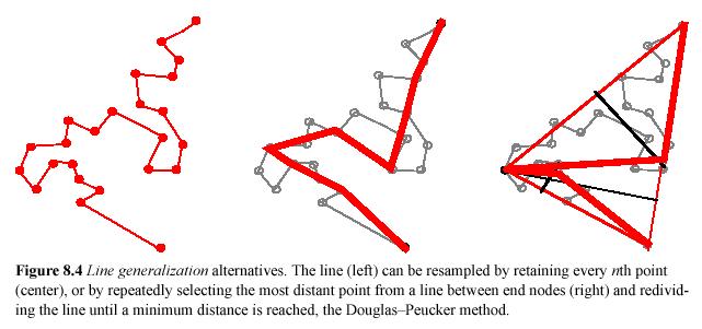
13 Line generalization
14 Storage Functions Compression Metadata handling Control via macros or languages Customization Format support Maintenance UpdateUpdate
15 Compression By data structure quad quad trees run run length encoding By data format compressed TIF jpegjpeg By physical compression digit digit handling
16 Data Management Functions Physical model support DBMS QueryQuery Address matching Masking Cookie cutting Clip Clip to study area
17 Cookie cutting
18 Data Retrieval and Analysis Functions Locating entities / finding records Selecting by attributes Selecting by Location BufferingBuffering Map Map overlay Map Map algebra
19 Map Algebra
20 Data Analysis Functions Buffering Map overlay Map algebra Interpolation - creating surfaces Optimal path selection Geometric tests - spatial relationships Slope calculation
21 Interpolation?
22 Data Display Functions Desktop mapping Interactive modification of cartographic elements Graphic file export
23 Functional Capabilities are By-products of Data Structure Raster systems work best in forestry, photogrammetry,, remote sensing, terrain analysis, and hydrology. Vector systems work best for land parcels, census data, precise positional data (GPS, fieldwork), and networks.
24 Vector Precision intact Used when individual coordinates are important More concise spatial description Assumes feature model of landscape Easy to transform data e.g. map projections
25 Raster Better for field data Used by most imaging systems Can be compressed Easy to display and analyze Many common formats However, most systems now use both Raster layer often backdrop-onscreen onscreen editing
26 The Big Eight Form the bulk of operational GIS in professional and educational environments There are some significant differences between these big eight systems.
27 Professional GIS Full featured Automation Manipulation Data access Query Spatial Analysis Visualization Mapping Advanced editing Customization $10,000

28 Arc/Info ESRI Redlands, CA Arc/Info Market leader workstation (mostly) remarkable functionality many formats supported ArcEdit ArcGRID ArcPlot INFO
29 ArcInfo 8
30 Desktop GIS Data exploitation Data access Query Spatial Analysis Simple editing Visualization Mapping Customization $1500

31 ArcView Versions 1-3, 3.1 PC Windows Avenue Web links Map Objects Extensions

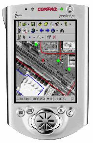
32 MapInfo Based in Troy, NY Mapping functions Limited GIS functionality Uses Visual Basic Many applications Favored for 911, field
33 MapInfo


34 AutoCAD MAP Windows all versions SQL DBF Access Extension to AutoCAD Menu-based Massive installed base Added grid, projection & topology support DB links good. 3D links good

35 GRASS First UNIX GIS Developed by Army Corps of Engineers UNIX functionality Many unique functions Free until recently Many data sets Baylor University now supports

36 IDRISI Developed at Clark University, Worcester MA Original in PASCAL, with open code Development uses a specialty Windows/DOS Spatial analysis/stats extensions

37 Maptitude Caliper Corporation Consultancy TRANSCAD and GIS+ Many network solutions Windows Import/Export Address matching

38 Microstation MGE CAD software with GIS extensions Intergraph Corp, Huntsville AL Uses Windows NT Many parcel applications Web extensions, server tools etc.
39 Hand-held Field-based GIS Lightweight hardware Extension of desktop Limited capabilities Data collection Mobile mapping $500

40 Autodesk OnSite & ArcPad
41 Component GIS Do it yourself GIS Software building blocks Embeddable Highly customizable Highly interoperable Lightweight, low cost deployments $5000 for 50 ($100 each)
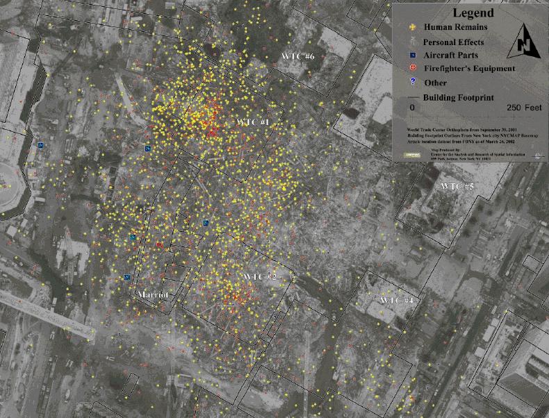
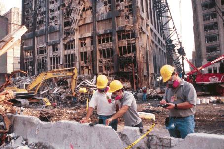
42 Internet GIS Distributed GIS Centralized service Simple, low cost Easy to use Map focused, some other services Read-only $7500 per server (10-30 users)
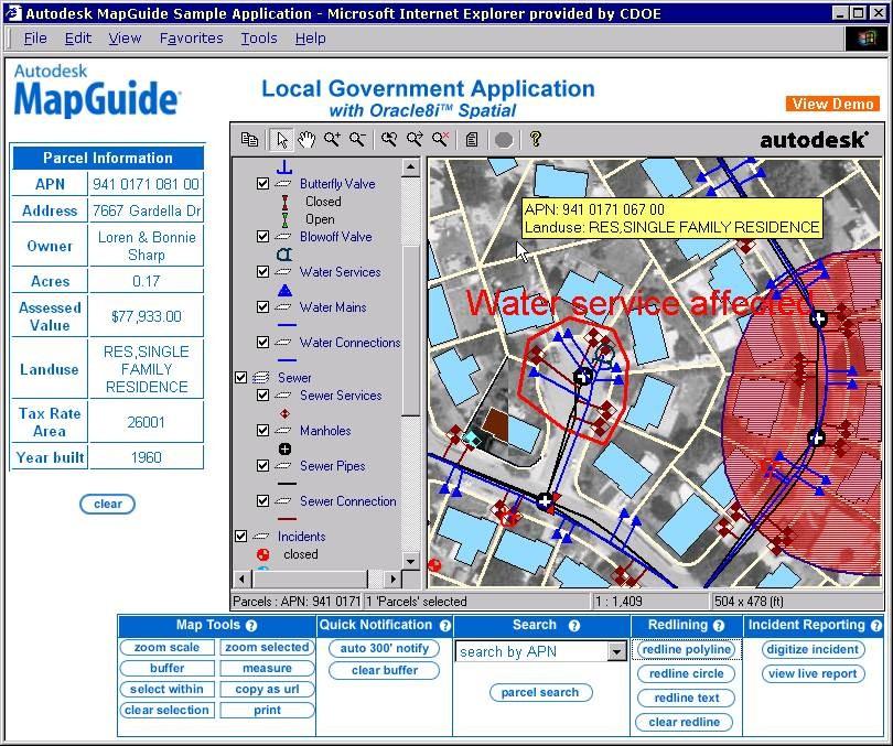
43 MapGuide
44 GIS Viewers Free GIS Lightweight Low cost Read only Mini-desktop GIS No customization $0!
45 A variety of issues should be considered in system selection: cost upgrades LAN configuration support training needs ease of installation maintenance documentation and manuals help-line line and vendor support means of making patches workforce
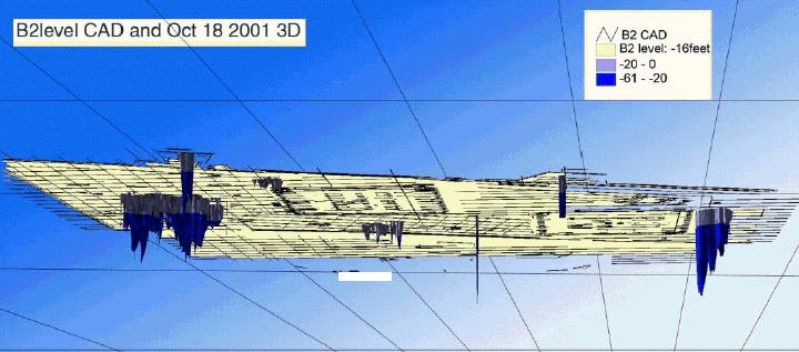
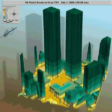
46 GIS Market Type of Software System Professional Desktop Hand-held Component Viewer Internet Users
47 Summary GIS software is developing fast Consistent GIS architecture Major development areas Internet Hand-held Increasingly standards-based Very wide ranging Rationalization of vendors
48 GIS Case Study
49 GIS IN ACTION September 11, 2001 The World Trade Center Towers, NYC


50 GIS World Trade Center operations at Pier 92 GIS support for firefighters, rescue workers, utility crews 24 hours a day / 7 days a week support for 2+ months 50+ GIS professionals
51 Data NYCMap Orthophotography Planimetric maps Thermal imagery LIDAR imagery GPS data


52 NYCMap 30 cm resolution orthophotography Planimetric map - absolute spatial accuracy of half a meter
53 LIDAR

54 Thermal imaging Thermal remote sensing data collected at the WTC on September 16. Source: Roger Clark, USGS, Open File report
55 GPS
56 Problems Maintaining building status database Unique identifiers for the buildings? Data consistency Data integrity TIME!
57 Lessons learned NYC GIS infrastructure was critical Cities should connect their spatial data to its attributes! Need for cartographic standards Need mobile access to GIS Version management for multi-user user environment
How to Pick a GIS. Choosing the GIS. GIS software in GIS in the 1980s. How to Pick a GIS
 How to Pick a GIS Getting Started With GIS GISs should, by definition, be capable of performing a key set of functions. we examine six of the most critical functions. Eight GIS packages are introduced,
Canadian Board of Examiners for Professional Surveyors Core Syllabus Item C 5: GEOSPATIAL INFORMATION SYSTEMS
 Study Guide: Canadian Board of Examiners for Professional Surveyors Core Syllabus Item C 5: GEOSPATIAL INFORMATION SYSTEMS This guide presents some study questions with specific referral to the essential
GIS Software. Evolution of GIS Software
 GIS Software The geoprocessing engines of GIS Major functions Collect, store, mange, query, analyze and present Key terms Program collections of instructions to manipulate data Package integrated collection
A Summary of State DOT GIS Activities. Presented at the 2000 AASHTO GIS-T Symposium Minneapolis, MN
 A Summary of State DOT GIS Activities Presented at the 2000 AASHTO GIS-T Symposium Minneapolis, MN Information Sources E-mail survey of state DOT GIS managers 49 State DOTs responded in 2000 Results compared
NAME HERE PERM # HERE
 NAME HERE PERM # HERE Geography 176A Final Examination 12/15/99 Answer all of the questions on the scanner sheet on the right of this first page by bubbling out your selection with a No. 2 pencil. Please
Introduction to the 176A labs and ArcGIS Purpose of the labs
 Introduction to the 176A labs and ArcGIS Purpose of the labs Acknowledgement: Slides by David Maidment, U Texas-Austin and Francisco Olivera (TAMU) Hands-on experience with a leading software package Introduction
Environmental Systems Research Institute
 Introduction to ArcGIS ESRI Environmental Systems Research Institute Redlands, California 2 ESRI GIS Development Arc/Info (coverage model) Versions 1-7 from 1980 1999 Arc Macro Language (AML) ArcView (shapefile
Geometric Algorithms in GIS
 Geometric Algorithms in GIS GIS Visualization Software Dr. M. Gavrilova GIS Software for Visualization ArcView GEO/SQL Digital Atmosphere AutoDesk Visual_Data GeoMedia GeoExpress CAVE? Visualization in
NR402 GIS Applications in Natural Resources
 NR402 GIS Applications in Natural Resources Lesson 1 Introduction to GIS Eva Strand, University of Idaho Map of the Pacific Northwest from http://www.or.blm.gov/gis/ Welcome to NR402 GIS Applications in
PC ARC/INFO and Data Automation Kit GIS Tools for Your PC
 ESRI PC ARC/INFO and Data Automation Kit GIS Tools for Your PC PC ARC/INFO High-quality digitizing and data entry Powerful topology building Cartographic design and query Spatial database query and analysis
UNIT 4: USING ArcGIS. Instructor: Emmanuel K. Appiah-Adjei (PhD) Department of Geological Engineering KNUST, Kumasi
 Department of Geological Engineering KNUST, Kumasi") UNIT 4: USING ArcGIS Instructor: Emmanuel K. Appiah-Adjei (PhD) Department of Geological Engineering KNUST, Kumasi Getting to Know ArcGIS ArcGIS is an integrated collection of GIS software products ArcGIS
UNIT 4: USING ArcGIS Instructor: Emmanuel K. Appiah-Adjei (PhD) Department of Geological Engineering KNUST, Kumasi Getting to Know ArcGIS ArcGIS is an integrated collection of GIS software products ArcGIS
Outline. Chapter 1. A history of products. What is ArcGIS? What is GIS? Some GIS applications Introducing the ArcGIS products How does GIS work?
 Outline Chapter 1 Introducing ArcGIS What is GIS? Some GIS applications Introducing the ArcGIS products How does GIS work? Basic data formats The ArcCatalog interface 1-1 1-2 A history of products Arc/Info
Display data in a map-like format so that geographic patterns and interrelationships are visible
 Vilmaliz Rodríguez Guzmán M.S. Student, Department of Geology University of Puerto Rico at Mayagüez Remote Sensing and Geographic Information Systems (GIS) Reference: James B. Campbell. Introduction to
Applications: Introduction Task 1: Introduction to ArcCatalog Task 2: Introduction to ArcMap Challenge Question References
 CHAPTER 1 INTRODUCTION 1.1 GIS? 1.1.1 Components of a GIS 1.1.2 A Brief History of GIS 1.1.3 GIS Software Products Box 1.1 A List of GIS Software Producers and Their Main Products 1.2 GIS Applications
GENERALIZATION IN THE NEW GENERATION OF GIS. Dan Lee ESRI, Inc. 380 New York Street Redlands, CA USA Fax:
 GENERALIZATION IN THE NEW GENERATION OF GIS Dan Lee ESRI, Inc. 380 New York Street Redlands, CA 92373 USA dlee@esri.com Fax: 909-793-5953 Abstract In the research and development of automated map generalization,
Esri Overview for Mentor Protégé Program:
 Agenda Passionate About Helping You Succeed Esri Overview for Mentor Protégé Program: Northrop Grumman CSSS Jeff Dawley 3 September 2010 Esri Overview ArcGIS as a System ArcGIS 10 - Map Production - Mobile
GIS-T 2010 Building a Successful Geospatial Data Sharing Framework: A Ohio DOT Success Story
 GIS-T 2010 Building a Successful Geospatial Data Sharing Framework: A Ohio DOT Success Story ODOT District 2 GIS John Puente District 1 GIS Coordinator\ Planning Administrator 2 Interoperability 3 District
Introduction to the 176A labs and ArcGIS
 Introduction to the 176A labs and ArcGIS Acknowledgement: Slides by David Maidment, U Texas-Austin and Francisco Olivera (TAMU) Purpose of the labs Hands-on experience with one software pakage Introduction
DATA SOURCES AND INPUT IN GIS. By Prof. A. Balasubramanian Centre for Advanced Studies in Earth Science, University of Mysore, Mysore
 DATA SOURCES AND INPUT IN GIS By Prof. A. Balasubramanian Centre for Advanced Studies in Earth Science, University of Mysore, Mysore 1 1. GIS stands for 'Geographic Information System'. It is a computer-based
M A P T I T U D E A L O W C O S T G I S / D E S K T O P M A P P I N G A L T E R N A T I V E
 M A P T I T U D E A L O W C O S T G I S / D E S K T O P M A P P I N G A L T E R N A T I V E Jeffrey L. Baumann Dispatch & Forest Technology Coordinator South Carolina Forestry Commission Columbia, South
ESRI Survey Summit August Clint Brown Director of ESRI Software Products
 ESRI Survey Summit August 2006 Clint Brown Director of ESRI Software Products Cadastral Fabric How does Cadastral fit with Survey? Surveyors process raw field observations Survey measurements define high-order
SRJC Applied Technology 54A Introduction to GIS
 SRJC Applied Technology 54A Introduction to GIS Overview Lecture of Geographic Information Systems Fall 2004 Santa Rosa Junior College Presented By: Tim Pudoff, GIS Coordinator, County of Sonoma, Information
Popular Mechanics, 1954
 Introduction to GIS Popular Mechanics, 1954 1986 $2,599 1 MB of RAM 2017, $750, 128 GB memory, 2 GB of RAM Computing power has increased exponentially over the past 30 years, Allowing the existence of
Understanding Geographic Information System GIS
 Understanding Geographic Information System GIS What do we know about GIS? G eographic I nformation Maps Data S ystem Computerized What do we know about maps? Types of Maps (Familiar Examples) Street Maps
Bentley Map Advancing GIS for the World s Infrastructure
 Bentley Map Advancing GIS for the World s Infrastructure Presentation Overview Why would you need Bentley Map? What is Bentley Map? Where is Bentley Map Used? Why would you need Bentley Map? Because your
These modules are covered with a brief information and practical in ArcGIS Software and open source software also like QGIS, ILWIS.
 Online GIS Training and training modules covered are: 1. ArcGIS, Analysis, Fundamentals and Implementation 2. ArcGIS Web Data Sharing 3. ArcGIS for Desktop 4. ArcGIS for Server These modules are covered
Introduction to Geographic Information Systems (GIS): Environmental Science Focus
: Environmental Science Focus") Introduction to Geographic Information Systems (GIS): Environmental Science Focus September 9, 2013 We will begin at 9:10 AM. Login info: Username:!cnrguest Password: gocal_bears Instructor: Domain: CAMPUS
Introduction to Geographic Information Systems (GIS): Environmental Science Focus September 9, 2013 We will begin at 9:10 AM. Login info: Username:!cnrguest Password: gocal_bears Instructor: Domain: CAMPUS
4. GIS Implementation of the TxDOT Hydrology Extensions
 4. GIS Implementation of the TxDOT Hydrology Extensions A Geographic Information System (GIS) is a computer-assisted system for the capture, storage, retrieval, analysis and display of spatial data. It
Innovation. The Push and Pull at ESRI. September Kevin Daugherty Cadastral/Land Records Industry Solutions Manager
 Innovation The Push and Pull at ESRI September 2004 Kevin Daugherty Cadastral/Land Records Industry Solutions Manager The Push and The Pull The Push is the information technology that drives research and
Among various open-source GIS programs, QGIS can be the best suitable option which can be used across partners for reasons outlined below.
 Comparison of Geographic Information Systems (GIS) software As of January 2018, WHO has reached an agreement with ESRI (an international supplier of GIS software) for an unlimited use of ArcGIS Desktop
8/28/2011. Contents. Lecture 1: Introduction to GIS. Dr. Bo Wu Learning Outcomes. Map A Geographic Language.
 Contents Lecture 1: Introduction to GIS Dr. Bo Wu lsbowu@polyu.edu.hk Department of Land Surveying & Geo-Informatics The Hong Kong Polytechnic University 1. Learning outcomes 2. GIS definition 3. GIS examples
FIRE DEPARMENT SANTA CLARA COUNTY
 DEFINITION FIRE DEPARMENT SANTA CLARA COUNTY GEOGRAPHIC INFORMATION SYSTEM (GIS) ANALYST Under the direction of the Information Technology Officer, the GIS Analyst provides geo-spatial strategic planning,
Introduction to Geographic Information Systems
 Introduction to Geographic Information Systems Lynn_Carlson@brown.edu 401-863-9917 The Environmental And Remote TecHnologies Lab MacMillan Hall, Room 105 http://www.brown.edu/research/earthlab/ Outline
WELCOME. To GEOG 350 / 550 Introduction to Geographic Information Science: Third Lecture
 WELCOME To GEOG 350 / 550 Introduction to Geographic Information Science: Third Lecture 1 Lecture 3: Overview Geographic Information Systems (GIS) A brief history of GIS Sources of information for GIS
Fundamentals of ArcGIS Desktop Pathway
 Fundamentals of ArcGIS Desktop Pathway Table of Contents ArcGIS Desktop I: Getting Started with GIS 3 ArcGIS Desktop II: Tools and Functionality 5 Understanding Geographic Data 8 Understanding Map Projections
GTK GeoKernel and Data Management. Material from Niina Ahtonen, Esa Kauniskangas and Tero Rönkkö
 GTK GeoKernel and Data Management Esa Kauniskangas 31.5.2010 Material from Niina Ahtonen, Esa Kauniskangas and Tero Rönkkö 1 GTK s operational areas Northern Finland Office Rovaniemi Western Finland Office
ArcGIS. for Server. Understanding our World
 ArcGIS for Server Understanding our World ArcGIS for Server Create, Distribute, and Manage GIS Services You can use ArcGIS for Server to create services from your mapping and geographic information system
Bentley Geospatial update
 Bentley Geospatial update Tallinna, 01.11.2007 Timo Tuukkanen, Bentley Systems Issues today Bentley Map available now detailed introduction to Bentley Map Bentley Geo Web Publisher Bentley Web GIS update,
Introduction to ArcGIS Server - Creating and Using GIS Services. Mark Ho Instructor Washington, DC
 Introduction to ArcGIS Server - Creating and Using GIS Services Mark Ho Instructor Washington, DC Technical Workshop Road Map Product overview Building server applications GIS services Developer Help resources
GIS and GNSS Integration
 METIS Second Master Training & Seminar GIS and GNSS Integration By Eng. Ramadan Salem M. Sc. Surveying and Geodesy Email: ramadan_salem@link.net Page 1 GIS and GNSS Integration: Plan of the Presentation
INTRODUCTION TO ARCGIS Version 10.*
 Week 3 INTRODUCTION TO ARCGIS Version 10.* topics of the week Overview of ArcGIS Using ArcCatalog Overview of ArcGIS Desktop ArcGIS Overview Scalable desktop applications ArcView ArcEditor ArcInfo ArcGIS
GEOGRAPHIC INFORMATION SYSTEM ANALYST I GEOGRAPHIC INFORMATION SYSTEM ANALYST II
 CITY OF ROSEVILLE GEOGRAPHIC INFORMATION SYSTEM ANALYST I GEOGRAPHIC INFORMATION SYSTEM ANALYST II DEFINITION To perform professional level work in Geographic Information Systems (GIS) management and analysis;
ArcGIS Tools for Professional Cartography
 ArcGIS Tools for Professional Cartography By Makram Murad-al-shaikh M.S. Cartography Senior instructor ESRI Educational Services ICC - A Coruña - Spain, 9-16 July, 2005 Overview Overview of the ArcGIS
RESOLUTION NO
 RESOLUTION NO. 09-2017 Adopting Job Descriptions for Engineering and GIS Manager and GIS Analyst and Amending the Pay Resolution to Accommodate Said Positions and Amending the Staffing Chart to Accommodate
Techniques for Science Teachers: Using GIS in Science Classrooms.
 Techniques for Science Teachers: Using GIS in Science Classrooms. After ESRI, 2008 GIS A Geographic Information System A collection of computer hardware, software, and geographic data used together for
Why GIS & Why Internet GIS?
 Why GIS & Why Internet GIS? The Internet bandwagon Internet mapping (e.g., MapQuest) Location-based services Real-time navigation (e.g., traffic) Real-time service dispatch Business Intelligence Spatial
GIS at JLAB. T. Larrieu Jefferson Lab, Newport News, VA 23606, USA. Controls Group. October 2006 PCaPAC
 GIS at JLAB T. Larrieu Jefferson Lab, Newport News, VA 23606, USA October 2006 PCaPAC Jefferson Lab has a Large and Complex Infrastructure CEBAF ( 24/7 electron utility ) 7 km of beamline 2000+ magnets
A Summary of State DOT GIS Activities. Presented at the 2004 AASHTO GIS-T Symposium Rapid City, SD
 A Summary of State DOT GIS Activities Presented at the 2004 AASHTO GIS-T Symposium Rapid City, SD Information Sources E-mail survey of state DOT GIS managers All 51 State DOTs (and DC) responded in 2004
ArcGIS Enterprise: What s New. Philip Heede Shannon Kalisky Melanie Summers Sam Williamson
 ArcGIS Enterprise: What s New Philip Heede Shannon Kalisky Melanie Summers Sam Williamson ArcGIS Enterprise is the new name for ArcGIS for Server What is ArcGIS Enterprise ArcGIS Enterprise is powerful
Introduction to GIS. Dr. M.S. Ganesh Prasad
 Introduction to GIS Dr. M.S. Ganesh Prasad Department of Civil Engineering The National Institute of Engineering, MYSORE ganeshprasad.nie@gmail.com 9449153758 Geographic Information System (GIS) Information
Esri Training by Microcenter Prepare to Innovate. Microcenter Course Catalog
 Esri Training by Microcenter Prepare to Innovate 2015 Instructor-Led Courses Microcenter Course Catalog ArcGIS Foundational Courses Designed to meet the learning needs of professionals whose GIS experience
Introduction to Geographic Information Systems
 Geog 58 Introduction to Geographic Information Systems, Fall, 2003 Page 1/8 Geography 58 Introduction to Geographic Information Systems Instructor: Lecture Hours: Lab Hours: X-period: Office Hours: Classroom:
Course overview. Grading and Evaluation. Final project. Where and When? Welcome to REM402 Applied Spatial Analysis in Natural Resources.
 Welcome to REM402 Applied Spatial Analysis in Natural Resources Eva Strand, University of Idaho Map of the Pacific Northwest from http://www.or.blm.gov/gis/ Where and When? Lectures Monday & Wednesday
GEOGRAPHIC INFORMATION SYSTEM (GES203)
") GEOGRAPHIC INFORMATION SYSTEM (GES203) GIS Components Level 2:1 By: Mrs Mupfiga Presentation Layout Recap Learning Objectives Components of GIS GIS Data References Lecture Evaluation Learning Objectives
GEOGRAPHIC INFORMATION SYSTEM (GES203) GIS Components Level 2:1 By: Mrs Mupfiga Presentation Layout Recap Learning Objectives Components of GIS GIS Data References Lecture Evaluation Learning Objectives
Lecture 1 Introduction to GIS. Dr. Zhang Spring, 2017
 Lecture 1 Introduction to GIS Dr. Zhang Spring, 2017 Topics of the course Using and making maps Navigating GIS Map design Working with spatial data Geoprocessing Spatial data infrastructure Digitizing
GIS Geographical Information Systems
 Chapter Two GIS Geographical Information Systems Chapter Two GIS Geographical Information Systems Chapter Two GIS (Geographical Information Systems) 2.1 Introduction In most cases of our day life, information
Transactions on Information and Communications Technologies vol 18, 1998 WIT Press, ISSN
 GIS in the process of road design N.C. Babic, D. Rebolj & L. Hanzic Civil Engineering Informatics Center, University ofmaribor, Faculty of Civil Engineering, Smetanova 17, 2000 Maribor, Slovenia. E-mail:
Thales Canada, System Division. BattleView: Integrating ArcGIS Into Canadian Army s Command And Control Application
 BattleView: Integrating ArcGIS Into Canadian Army s Command And Control Application BattleView Overview Canadian Army s command and control (C2) application Deployed in army headquarters unit and above
DP Project Development Pvt. Ltd.
 Dear Sir/Madam, Greetings!!! Thanks for contacting DP Project Development for your training requirement. DP Project Development is leading professional training provider in GIS technologies and GIS application
Teaching GIS for Land Surveying
 Teaching GIS for Land Surveying Zhanjing (John) Yu Evergreen Valley College, San Jose, California James Crossfield California State University at Fresno, Fresno California 7/13/2006 1 Outline of the Presentation
Enabling ENVI. ArcGIS for Server
 Enabling ENVI throughh ArcGIS for Server 1 Imagery: A Unique and Valuable Source of Data Imagery is not just a base map, but a layer of rich information that can address problems faced by GIS users. >
Introduction-Overview. Why use a GIS? What can a GIS do? Spatial (coordinate) data model Relational (tabular) data model
 data model Relational (tabular) data model") Introduction-Overview Why use a GIS? What can a GIS do? How does a GIS work? GIS definitions Spatial (coordinate) data model Relational (tabular) data model intro_gis.ppt 1 Why use a GIS? An extension
Introduction-Overview Why use a GIS? What can a GIS do? How does a GIS work? GIS definitions Spatial (coordinate) data model Relational (tabular) data model intro_gis.ppt 1 Why use a GIS? An extension
An Introduction to Geographic Information System
 An Introduction to Geographic Information System PROF. Dr. Yuji MURAYAMA Khun Kyaw Aung Hein 1 July 21,2010 GIS: A Formal Definition A system for capturing, storing, checking, Integrating, manipulating,
WELCOME. to EEOS Computer Applications in Geography. Getting Started with Geographic Information Systems
 WELCOME to EEOS 265 - Computer Applications in Geography Getting Started with Geographic Information Systems What will you learn? An overview of GIS How GIS data are captured, stored, retrieved, analyzed
Exelis and Esri Technologies for Defense and National Security. Cherie Muleh
 Exelis and Esri Technologies for Defense and National Security Cherie Muleh Cherie.Muleh@exelisinc.com ENVI IMAGERY AND DATA BECOME KNOWLEDGE > Add information from imagery to your GIS > Automated workflows
What is GIS? G: Geographic, Geospatial, Geo
 GEOG 488/588: GIS I Introduction Instructor: Geoffrey Duh TA: David Graves What is GIS? G: Geographic, Geospatial, Geo Alternatives: Spatial Information Systems, Land Information Systems Geography diverse
The Emerging Role of Enterprise GIS in State Forest Agencies
 The Emerging Role of Enterprise GIS in State Forest Agencies Geographic Information System (GIS) A geographic information system (GIS) is a computer software system designed to capture, store, manipulate,
SCAUG GIS Survey. GIS Manager % GIS Specialist % GIS Technician % GIS Coordinator % Analyst 16 9.
 Q1: Describe your current position: GIS Manager 25 14.71% GIS Specialist 25 14.71% GIS Technician 23 13.53% GIS Coordinator 19 11.18% Analyst 16 9.41% Senior GIS Analyst 11 6.47% Other 10 5.88% GIS Director
GIS = Geographic Information Systems;
 What is GIS GIS = Geographic Information Systems; What Information are we talking about? Information about anything that has a place (e.g. locations of features, address of people) on Earth s surface,
Write a report (6-7 pages, double space) on some examples of Internet Applications. You can choose only ONE of the following application areas:
 on some examples of Internet Applications. You can choose only ONE of the following application areas:") UPR 6905 Internet GIS Homework 1 Yong Hong Guo September 9, 2008 Write a report (6-7 pages, double space) on some examples of Internet Applications. You can choose only ONE of the following application
UPR 6905 Internet GIS Homework 1 Yong Hong Guo September 9, 2008 Write a report (6-7 pages, double space) on some examples of Internet Applications. You can choose only ONE of the following application
Geodatabase Management Pathway
 Geodatabase Management Pathway Table of Contents ArcGIS Desktop II: Tools and Functionality 3 ArcGIS Desktop III: GIS Workflows and Analysis 6 Building Geodatabases 8 Data Management in the Multiuser Geodatabase
Geometric Algorithms in GIS
 Geometric Algorithms in GIS GIS Software Dr. M. Gavrilova GIS System What is a GIS system? A system containing spatially referenced data that can be analyzed and converted to new information for a specific
JOB TITLE: CURRENT CLASSIFICATION/GRID POSITION # GIS Coordinator AD Grid Level 6(c) # 420
 # 420") COUNTY OF GRANDE PRAIRIE JOB DESCRIPTION JOB TITLE: CURRENT CLASSIFICATION/GRID POSITION # GIS Coordinator AD Grid Level 6(c) # 420 NOC CODE: 2255 STANDARD HOURS: 35 hours/week (non-management) JOB TITLE
COUNTY OF GRANDE PRAIRIE JOB DESCRIPTION JOB TITLE: CURRENT CLASSIFICATION/GRID POSITION # GIS Coordinator AD Grid Level 6(c) # 420 NOC CODE: 2255 STANDARD HOURS: 35 hours/week (non-management) JOB TITLE
Imagery and the Location-enabled Platform in State and Local Government
 Imagery and the Location-enabled Platform in State and Local Government Fred Limp, Director, CAST Jim Farley, Vice President, Leica Geosystems Oracle Spatial Users Group Denver, March 10, 2005 TM TM Discussion
Introduction to GIS. Geol 4048 Geological Applications of Remote Sensing
 Introduction to GIS Geol 4048 Geological Applications of Remote Sensing GIS History: Before Computers GIS History Using maps for a long time Dr. Roger F. Tomlinson Father of GIS He was an English geographer
Application of GIS in Public Transportation Case-study: Almada, Portugal
 Case-study: Almada, Portugal Doutor Jorge Ferreira 1 FSCH/UNL Av Berna 26 C 1069-061 Lisboa, Portugal +351 21 7908300 jr.ferreira@fcsh.unl.pt 2 FSCH/UNL Dra. FCSH/UNL +351 914693843, leite.ines@gmail.com
Lecture 11. Data Standards and Quality & New Developments in GIS
 Lecture 11 Data Standards and Quality & New Developments in GIS Lecture 11: Outline I. Data Standards and Quality 1. Types of Spatial Data Standards 2. Data Accuracy II. New Developments/The Future of
How does ArcGIS Server integrate into an Enterprise Environment? Willy Lynch Mining Industry Specialist ESRI, Denver, Colorado USA
 How does ArcGIS Server integrate into an Enterprise Environment? Willy Lynch Mining Industry Specialist ESRI, Denver, Colorado USA wlynch@esri.com ArcGIS Server Technology Transfer 1 Agenda Who is ESRI?
GED 554 IT & GIS INTRODUCTION TO THE COURSE CHAPTER 1
 GED 554 IT & GIS INTRODUCTION TO THE COURSE CHAPTER 1 March 1, 2013 Lines before starting class 1. Initial Introductions 2. Usage of the building 3. Assistance 4. Timetable 5. Curriculum 6. Introduction
Introduction to GIS I
 Introduction to GIS Introduction How to answer geographical questions such as follows: What is the population of a particular city? What are the characteristics of the soils in a particular land parcel?
GIS Geographic Information System
 GIS Geographic Information System Andrea Petroselli Tuscia University, Italy petro@unitus.it SUMMARY Part 1: Part 2: Part 3: Part 4: What is a GIS? Why do we need a GIS? Which are the possibilities of
Technical Specifications. Form of the standard
 Used by popular acceptance Voluntary Implementation Mandatory Legally enforced Technical Specifications Conventions Guidelines Form of the standard Restrictive Information System Structures Contents Values
a system for input, storage, manipulation, and output of geographic information. GIS combines software with hardware,
 Introduction to GIS Dr. Pranjit Kr. Sarma Assistant Professor Department of Geography Mangaldi College Mobile: +91 94357 04398 What is a GIS a system for input, storage, manipulation, and output of geographic
Geog 469 GIS Workshop. Data Analysis
 Geog 469 GIS Workshop Data Analysis Outline 1. What kinds of need-to-know questions can be addressed using GIS data analysis? 2. What is a typology of GIS operations? 3. What kinds of operations are useful
Chapter 1. GIS Fundamentals
 1. GIS Overview Chapter 1. GIS Fundamentals GIS refers to three integrated parts. Geographic: Of the real world; the spatial realities, the geography. Information: Data and information; their meaning and
Massachusetts Institute of Technology Department of Urban Studies and Planning
 Massachusetts Institute of Technology Department of Urban Studies and Planning 11.520: A Workshop on Geographic Information Systems 11.188: Urban Planning and Social Science Laboratory GIS Principles &
Applied Cartography and Introduction to GIS GEOG 2017 EL. Lecture-2 Chapters 3 and 4
 Applied Cartography and Introduction to GIS GEOG 2017 EL Lecture-2 Chapters 3 and 4 Vector Data Modeling To prepare spatial data for computer processing: Use x,y coordinates to represent spatial features
YYT-C3002 Application Programming in Engineering GIS I. Anas Altartouri Otaniemi
 YYT-C3002 Application Programming in Engineering GIS I Otaniemi Overview: GIS lectures & exercise We will deal with GIS application development in two lectures. Because of the versatility of GIS data models
Technical Trends in Geo Information
 Technical Trends in Geo Information Joachim WIESEL 1 Introduction Geo Information Systems as a small part of the IT-Industry is a fast changing technology, driven by market demands and technical advances.
Fundamentals of Geographic Information System PROF. DR. YUJI MURAYAMA RONALD C. ESTOQUE JUNE 28, 2010
 Fundamentals of Geographic Information System 1 PROF. DR. YUJI MURAYAMA RONALD C. ESTOQUE JUNE 28, 2010 CONTENTS OF THIS LECTURE PRESENTATION Basic concept of GIS Basic elements of GIS Types of GIS data
GIS TECHNICIAN I GIS TECHNICIAN II
 GIS TECHNICIAN I GIS TECHNICIAN II CITY OF ROSEVILLE DEFINITION To perform a variety of technical office and field work duties related to the creation and maintenance of maps, tables, graphs and other
ArcGIS Enterprise: What s New. Philip Heede Shannon Kalisky Melanie Summers Shreyas Shinde
 ArcGIS Enterprise: What s New Philip Heede Shannon Kalisky Melanie Summers Shreyas Shinde ArcGIS Enterprise is the new name for ArcGIS for Server ArcGIS Enterprise Software Components ArcGIS Server Portal
FUTURE DATA. Future data Future hardware Future software Future issues. Getting Started With GIS. Chapter 10
 THE FUTURE OF GIS Getting Started With GIS Chapter 10 GIS Futures Future data Future hardware Future software Future issues Dursun Z. ªeker Theme of the book GIS's place in understanding geographic distributions
Features and Benefits
 Autodesk LandXplorer Features and Benefits Use the Autodesk LandXplorer software family to help improve decision making, lower costs, view and share changes, and avoid the expense of creating physical
INTRODUCTION AND PRINCIPLES OF GIS. Sunil Kumar. Introduction
 INTRODUCTION AND PRINCIPLES OF GIS Introduction Sunil Kumar Director, NWA Geographic Information System (GIS) is a computer based system designed to accept large volume of spatial data derived from a variety
Oakland County Parks and Recreation GIS Implementation Plan
 Oakland County Parks and Recreation GIS Implementation Plan TABLE OF CONTENTS 1.0 Introduction... 3 1.1 What is GIS? 1.2 Purpose 1.3 Background 2.0 Software... 4 2.1 ArcGIS Desktop 2.2 ArcGIS Explorer
GEOGRAPHY 350/550 Final Exam Fall 2005 NAME:
 1) A GIS data model using an array of cells to store spatial data is termed: a) Topology b) Vector c) Object d) Raster 2) Metadata a) Usually includes map projection, scale, data types and origin, resolution
ArcGIS 10.1 An Overview of the System
 ArcGIS 10.1 An Overview of the System ArcGIS 10.1 An Overview of the System Damian Spangrud Director of Solutions, Esri Redlands, CA USA ArcGIS 10.1 Web Cloud Online Mobile Enterprise Desktop ArcGIS 10.1
FUNDAMENTALS OF GEOINFORMATICS PART-II (CLASS: FYBSc SEM- II)
") FUNDAMENTALS OF GEOINFORMATICS PART-II (CLASS: FYBSc SEM- II) UNIT:-I: INTRODUCTION TO GIS 1.1.Definition, Potential of GIS, Concept of Space and Time 1.2.Components of GIS, Evolution/Origin and Objectives
FUNDAMENTALS OF GEOINFORMATICS PART-II (CLASS: FYBSc SEM- II) UNIT:-I: INTRODUCTION TO GIS 1.1.Definition, Potential of GIS, Concept of Space and Time 1.2.Components of GIS, Evolution/Origin and Objectives
Syllabus Reminders. Geographic Information Systems. Components of GIS. Lecture 1 Outline. Lecture 1 Introduction to Geographic Information Systems
 Syllabus Reminders Geographic Information s Lecture Introduction to Geographic Information s. Class Info: www.saigis.com/class/ 2. Office T / TH (8:00-9:30 a.m.) and (2:30 3:30pm) or Appt 3. Email: burgerpr@unk.edu