Spectroscopy-supported digital soil mapping
|
|
|
- Raymond Allen
- 5 years ago
- Views:
Transcription
1 Spectroscopy-supported digital soil mapping
2 Outline Introduction Project and theoretical background Field sampling Estimating and mapping soil mineralogy Conclusion & outlook
3 The nation that destroys its soils destroys itself Frankling D. Roosevelt, Letter to all State Governors on a Uniform Soil Conservation Law (26 February, 1937) BACKGROUND In the epoch of the Anthropocene, human-driven changes affected the functioning of the Earth System. Nowadays, we need to adapt to climate changes and assure food security for the growing human population. Here, soil resources provide key ecosystem services and they need to be mapped and monitored on regional and global scale. Source: Sustainable Development Solutions Network, United Nations, Solutions for sustainable agriculture and food systems, 2013.

4 Problems Missing data and too general information Low accuracy How to use soil classes for modelling environmental processes Source: FAO Soil map of the World
5 e-soter: enhanced Soil and Terrain Database Regional soil and terrain mapping Web-based regional pilot platform Data, methodologies, and applications Using remote sensing to validate, augment and extend existing data
6 OBJECTIVE To exploit the use of remote (RS) and proximal sensing (PS) methodologies for digital soil mapping (DSM) to facilitate soil property mapping at regional scale.
7 Digital soil mapping The creation and population of spatial soil information by the use of field and laboratory observation methods coupled with spatial and non-spatial soil inference systems (Carré et al., 2007) 1. Goal: Spatial patterns of soils across various spatial and temporal scales 2. Local soil observations Field, laboratory and PS observations 3. Exhaustive datasets Spatially explicit maps, e.g. existing soil maps or RS data & product 4. Statistical methods Regression models Data mining Geostatistics F. Carré, A.B., McBratney, T. Mayr, L. Montanarella (2007). Digital soil assessments: Beyond DSM. Geoderma, 142 (1-2),
 energy reflected or emitted from the objects of interest at the surface of")
8 Remote Sensing RS is the science/ are the techniques of deriving information about the Earth s land and water areas from images at a distance It relies upon measurement of electro-magnetic (EM) energy reflected or emitted from the objects of interest at the surface of the Earth

9 Remote and proximal sensing

10 Remote and proximal sensing Absorption feature Broad bands
11 Workflow digital soil mapping (DSM) Source: Africa Soil Information Service,


12 Spectroscopy-supported digital soil mapping (I) Traditional Spectroscopy Data collection Fieldwork Maroc: soil profile description Fieldwork Maroc: Spectral measurements Soil measurements Laboratory measurements: X-ray diffraction Laboratory measurements: Spectral measurements V.L. Mulder, S. de Bruin, M.E. Schaepman, T.R. Mayr (2011). The use of remote sensing in soil and terrain mapping A review. Geoderma, 162- (1-2), doi: /j.geoderm
13 What is the current state-of-art in the use of remote sensing for soil and terrain mapping? Use Proximal Sensing Remote sensing Estimating soil properties: Quantitative Qualitative +/ Characterizing the landscape - + Spatial interpolation - + Associated spatial scale Point - Local Local - Global V.L. Mulder, S. de Bruin, M.E. Schaepman, T.R. Mayr (2011). The use of remote sensing in soil and terrain mapping A review. Geoderma, 162- (1-2), doi: /j.geoderm

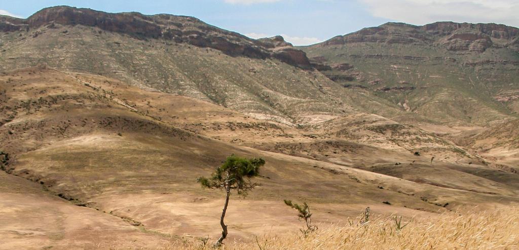
14 Study area Rif Mountains Anti-Atlas Mountains V.L. Mulder, S. de Bruin, M.E. Schaepman (2012). Representing major soil variability at regional scale by constrained Latin Hypercube Sampling of remote sensing data. International Journal of Applied Earth Observation and Geoinformation, (21) doi: /j.jag

15 Topography Fertility Source: Fieldwork campaign Maroc, 2010
16 MAIN FINDINGS


17 SAMPLING 2 weeks in the field Few legacy data km2 Time & financial limitations Can major soil variability at regional scale be represented by a sparse remote sensing-based sampling approach? V.L. Mulder, S. de Bruin, M.E. Schaepman (2012). Representing major soil variability at regional scale by constrained Latin Hypercube Samping of remote sensing data. International Journal of Applied Earth Observation and Geoinformation, (21) doi: /j.jag
18 Soil-landscape paradigm (Jenny) Soil formation = Climate, Organisms, Relief, Parent material & Time (CLORPT) Reflectance + elevation represents CLORPT Latin Hypercube sampling Input: Satellite and elevation data as a variability measure of soils Constrained by subareas, distance to the roads and steepness of the landscape Cost function f(x)= areas + distance + topography + water 100 sites were optimised to optimally sample the Latin Hypercube (LH) Minimize cost while sampling the marginal distributions within the LH The sample provides thematic information (fit prediction models) The RS data provides the necessary spatial context (extrapolation to full spatial extend) V.L. Mulder, S. de Bruin, M.E. Schaepman (2012). Representing major soil variability at regional scale by constrained Latin Hypercube Samping of remote sensing data. International Journal of Applied Earth Observation and Geoinformation, (21) doi: /j.jag
.")
19 Sampling Common practise RS-based sampling approach Expensive Accessibility Sampled variability Variability observed in RS data (PCA) Subareas, distance to road, steepness of the landscape Captured major soil variability in study area V.L. Mulder, S. de Bruin, M.E. Schaepman (2012). Representing major soil variability at regional scale by constrained Latin Hypercube Sampling of remote sensing data. International Journal of Applied Earth Observation and Geoinformation, (21) doi: /j.jag


20 RETRIEVAL Which methods allow retrieval of mineralogy from mixtures using proximal sensing?


21 Measurements (I) Field Standard analysis OR Spectral analysis Source: Canadian Wildlife federation Prepared samples for X-ray diffraction Prepared samples for spectroscopic measurements Measurements of soil properties using spectroscopy Soil mineralogy Experiment 1: Classification of mineral classes Experiment 2: Retrieval of individual mineral abundances Mineral maps? Experiment 1: V.L. Mulder, S de Bruin, M.E. Schaepman, (2012). Retrieval of composite mineralogy by VNIR spectroscopy, 5th Global Workshop on Digital Soil Mapping 2012, Sydney, Australia.
22 Problem: inference of mineralogy 1. Many minerals in a single sample 2. Absorption features not distinct V.L. Mulder, S de Bruin, M.E. Schaepman, (2012). Retrieval of composite mineralogy by VNIR spectroscopy, 5th Global Workshop on Digital Soil Mapping 2012, Sydney, Australia.
23 Experiment 1: Mineral Identification & Classification Algorithm (MICA) USGS Processing Routines in IDL for Spectroscopic Measurements (PRISM) Results Mineral categories Overall accuracy 52% Mineral Calcite-rich Calcite-poor Kaolinite Smectite 6 27 Dioctahedral Mica V.L. Mulder, S de Bruin, M.E. Schaepman, (2012). Retrieval of composite mineralogy by VNIR spectroscopy, 5th Global Workshop on Digital Soil Mapping 2012, Sydney, Australia.
24 Spectral deconvolution coupled with regression tree analysis Method Results (natural samples) Asymmetry Width Intensity Saturation V.L. Mulder, M. Plotze, S. de Bruin, S., M.E. Schaepman, C. Mavris, R. Kokaly, M. Egli, M., (2013). Quantifying mineral abundances of complex mixtures by coupling spectral deconvolution of SWIR spectra ( µm) and regression tree analysis. Geoderma, (207) DOI: /j.geoderma


25 Why? Remember: 100 samples Represent major variability Very low spatial correlation RS data: high resolution high variability Result: few compatibility in variability Smoothing the RS data represent similar variability as the sampled soils MAPPING Can scale-dependent variability be extracted from remote sensing and do model predictions improve by using scaled remote sensing that match the variability of the sample?
26 Methods Fixed Rank Kriging (Cressie and Johannesson, 2008) Handles large datasets Interpolate gaps Smoothing data based on medium and long-scale processes Model soil mineralogy 1. Mineral categories & mineral abundances 2. Predictor variables from satellite data Statistical relation between 1 & 2 Cressie, N., Johannesson, G., Fixed rank kriging for very large spatial data sets. Journal of the Royal Statistical Society. Series B: Statistical Methodology 70(1),
. Characterizing regional soil mineral composition using spectroscopy and geostatistics. Remote Sensing of Environment (139),415-429. DOI: 10.1016/j.rse.")
27 Characterizing regional soil mineralogy (II) R adj 2 = 0.70 RMSE cal = 4.6 RMSE val = 6 R adj 2 = 0.71 RMSE cal = 8.9 RMSE val = 12 Overall accuracy 76% V.L. Mulder, S. de Bruin, S., J. Weyermann, R. Kokaly, M.E. Schaepman, (2013). Characterizing regional soil mineral composition using spectroscopy and geostatistics. Remote Sensing of Environment (139), DOI: /j.rse
28 GENERAL CONCLUSION Spectroscopy-supported digital soil mapping is time and cost efficient for large-scale soil assessments Improvements in regional-scale DSM result from the integrated use of remote sensing with geostatistical methods OUTLOOK To deliver accurate and comprehensive information about soils, soil resources and ecosystem services provided by soils at regional and ultimately global scale

29 Essentially, all life depends upon the soil. There can be no life without soil and no soil without life; they have evolved together. American naturalist Charles Kellogg, Thank you all
Sneak Preview of the Saskatchewan Soil Information System (SKSIS)
") Sneak Preview of the Saskatchewan Soil Information System (SKSIS) Angela Bedard-Haughn 1, Ken Van Rees 1, Murray Bentham 1, Paul Krug 1 Kent Walters 1,3, Brandon Heung 2, Tom Jamsrandorj 3 Ralph Deters
Sneak Preview of the Saskatchewan Soil Information System (SKSIS) Angela Bedard-Haughn 1, Ken Van Rees 1, Murray Bentham 1, Paul Krug 1 Kent Walters 1,3, Brandon Heung 2, Tom Jamsrandorj 3 Ralph Deters
USE OF RADIOMETRICS IN SOIL SURVEY
 USE OF RADIOMETRICS IN SOIL SURVEY Brian Tunstall 2003 Abstract The objectives and requirements with soil mapping are summarised. The capacities for different methods to address these objectives and requirements
PREDICTION OF SOIL ORGANIC CARBON CONTENT BY SPECTROSCOPY AT EUROPEAN SCALE USING A LOCAL PARTIAL LEAST SQUARE REGRESSION APPROACH
 Proceedings of the 13 th International Conference on Environmental Science and Technology Athens, Greece, 5-7 September 2013 PREDICTION OF SOIL ORGANIC CARBON CONTENT BY SPECTROSCOPY AT EUROPEAN SCALE
e-soter at scale 1: for the Danube Basin Vincent van Engelen
 e-soter at scale 1:250 000 for the Danube Basin Vincent van Engelen Underlying the SOTER methodology is the identification of areas of land with a distinctive, often repetitive, pattern of landform, lithology,
A Small Migrating Herd. Mapping Wildlife Distribution 1. Mapping Wildlife Distribution 2. Conservation & Reserve Management
 A Basic Introduction to Wildlife Mapping & Modeling ~~~~~~~~~~ Rev. Ronald J. Wasowski, C.S.C. Associate Professor of Environmental Science University of Portland Portland, Oregon 8 December 2015 Introduction
Global SoilMappingin a Changing World
 Global SoilMappingin a Changing World Sabine Grunwald Acknowledgements: GIS-Pedometrics Team, UF Soil Story My soil story. Your soil story Digital Soil Mapping in a Changing World Global climate change,
Technical Drafting, Geographic Information Systems and Computer- Based Cartography
 Technical Drafting, Geographic Information Systems and Computer- Based Cartography Project-Specific and Regional Resource Mapping Services Geographic Information Systems - Spatial Analysis Terrestrial
HYPERSPECTRAL IMAGING
 1 HYPERSPECTRAL IMAGING Lecture 9 Multispectral Vs. Hyperspectral 2 The term hyperspectral usually refers to an instrument whose spectral bands are constrained to the region of solar illumination, i.e.,
Spectroscopy-supported digital soil mapping
 Spectroscopy-supported digital soil mapping V.L. (Titia) Mulder Thesis committee Thesis supervisor Prof. dr. M.E. Schaepman Professor of Remote Sensing, University of Zürich, Switzerland Professor of Geo-information
Prediction of Soil Properties Using Fuzzy Membership
 Prediction of Soil Properties Using Fuzzy Membership Zhu, A.X. 1,2 ; Moore, A. 3 ; Burt, J. E. 2 1 State Key Lab of Resources and Environmental Information System, Institute of Geographical Sciences and
Placer Potential Map. Dawson L and U se P lan. Jeffrey Bond. Yukon Geological Survey
 Placer Potential Map Dawson L and U se P lan By Jeffrey Bond Yukon Geological Survey Dawson Land Use Plan Placer Potential Map 1.0 Introduction Placer mining has been an important economic driver within
Capabilities and Limitations of Land Cover and Satellite Data for Biomass Estimation in African Ecosystems Valerio Avitabile
 Capabilities and Limitations of Land Cover and Satellite Data for Biomass Estimation in African Ecosystems Valerio Avitabile Kaniyo Pabidi - Budongo Forest Reserve November 13th, 2008 Outline of the presentation
CLICK HERE TO KNOW MORE
 CLICK HERE TO KNOW MORE Geoinformatics Applications in Land Resources Management G.P. Obi Reddy National Bureau of Soil Survey & Land Use Planning Indian Council of Agricultural Research Amravati Road,
Dealing with soil organic carbon mapping at different levels in Madagascar
 Dealing with soil organic carbon mapping at different levels in Madagascar N. Ramifehiarivo, A. Andriamananjara, H. Razafimahatratra, T. Razafimbelo, M. Rabenarivo, A.Rasolohery, N. Ranaivoson, C. Grinand,
Overview and Recent Developments
 SoLIM: An Effort Moving DSM into the Digital Era Overview and Recent Developments A-Xing Zhu 1,2 1 Department of Geography University of Wisconsin-Madison azhu@wisc.edu 2 Institute of Geographical Sciences
Application of near-infrared (NIR) spectroscopy to sensor based sorting of an epithermal Au-Ag ore
 spectroscopy to sensor based sorting of an epithermal Au-Ag ore") Application of near-infrared (NIR) spectroscopy to sensor based sorting of an epithermal Au-Ag ore OCM conference presentation 19-03-2015 TU Delft, Resource Engineering M.Dalm MSc. 1 Contents of the presentation
Application of near-infrared (NIR) spectroscopy to sensor based sorting of an epithermal Au-Ag ore OCM conference presentation 19-03-2015 TU Delft, Resource Engineering M.Dalm MSc. 1 Contents of the presentation
Applicability of Near-Infrared (NIR) spectroscopy for sensor based sorting of a porphyry copper ore.
 spectroscopy for sensor based sorting of a porphyry copper ore.") Applicability of Near-Infrared (NIR) spectroscopy for sensor based sorting of a porphyry copper ore. OCM conference presentation 07-03-2013 TU Delft, Resource Engineering section M.Dalm MSc. 1 Table of
Applicability of Near-Infrared (NIR) spectroscopy for sensor based sorting of a porphyry copper ore. OCM conference presentation 07-03-2013 TU Delft, Resource Engineering section M.Dalm MSc. 1 Table of
Supplementary material: Methodological annex
 1 Supplementary material: Methodological annex Correcting the spatial representation bias: the grid sample approach Our land-use time series used non-ideal data sources, which differed in spatial and thematic
Land Accounts - The Canadian Experience
 Land Accounts - The Canadian Experience Development of a Geospatial database to measure the effect of human activity on the environment Who is doing Land Accounts Statistics Canada (national) Component
1 INTRODUCTION. 1.1 Context
 1 INTRODUCTION 1.1 Context During the last 30 years ski run construction has been one of the major human activities affecting the Alpine environment. The impact of skiing on environmental factors and processes,
Scout Aerial Africa DRONES THE BIG PICTURE FOR GEOLOGY AND MINING
 Scout Aerial Africa DRONES THE BIG PICTURE FOR GEOLOGY AND MINING WHO ARE WE? Scout Aerial Group is a diversified operating and investment group with market leading businesses and targeted investment in
Extraction and Integration of Mineralogical and Topographic Information Derived from ASTER and DEM Data
 Extraction and Integration of Mineralogical and Topographic Information Derived from ASTER and DEM Data Yasushi Yamaguchi, K. Kurata, R. Hirai (Nagoya Univ.) S. Noda (JOGMEC), and S. Kodama (GSJ) GRSG
Introduction to GIS I
 Introduction to GIS Introduction How to answer geographical questions such as follows: What is the population of a particular city? What are the characteristics of the soils in a particular land parcel?
The Soil Atlas of the Northern Circumpolar Region
 Conference Soil, Climate Change and Biodiversity Where do we stand? Brussels, Thursday 23rd and Friday 24th September 2010 1 The Soil Atlas of the Northern Circumpolar Region Luca Montanarella European
Introduction of the Asia-Oceania Global Earth Observation System of Systems (AOGEOSS) GEO Initiative(GI-22 )
 GEO Initiative(GI-22 )") Introduction of the Asia-Oceania Global Earth Observation System of Systems (AOGEOSS) GEO Initiative(GI-22 ) Prof. Xiang ZHOU Institute of Remote Sensing and Digital Earth, CAS 11 May 2017 Kunming, China
Introduction of the Asia-Oceania Global Earth Observation System of Systems (AOGEOSS) GEO Initiative(GI-22 ) Prof. Xiang ZHOU Institute of Remote Sensing and Digital Earth, CAS 11 May 2017 Kunming, China
Wayne E. Sirmon GEO 301 World Regional Geography
 Wayne E. Sirmon GEO 301 Geography 301 Geography 301 MAP: A graphic representation of a portion of the earth s surface dawn to scale, as seen from above. Types of Maps Climate maps give general information
The Dynamics of Potassium in some. Australian soils
 The Dynamics of Potassium in some Australian soils Serhiy Marchuk In fulfilment of the degree of DOCTOR OF PHILOSOPHY Soil Science Group School of Agriculture, Food and Wine The University of Adelaide
Advanced Image Analysis in Disaster Response
 Advanced Image Analysis in Disaster Response Creating Geographic Knowledge Thomas Harris ITT The information contained in this document pertains to software products and services that are subject to the
ANALYSIS OF LARGE SCALE SOIL SPECTRAL LIBRARIES
 Antoine Stevens (1), Marco Nocita (1,2), & Bas van Wesemael (1) ANALYSIS OF LARGE SCALE SOIL SPECTRAL LIBRARIES 1 Georges Lemaître Centre for Earth and Climate Research, Earth and Life Institute, UCLouvain,
Geoscape Capturing Australia s Built Environment for emergency modelling and management. Dan Paull Chief Executive Officer PSMA Australia
 Geoscape Capturing Australia s Built Environment for emergency modelling and management Dan Paull Chief Executive Officer PSMA Australia There is no wealth like knowledge, and no poverty like ignorance.
for XPS surface analysis
 Thermo Scientific Avantage XPS Software Powerful instrument operation and data processing for XPS surface analysis Avantage Software Atomic Concentration (%) 100 The premier software for surface analysis
Versioning of GlobalSoilMap.net raster property maps for the North American Node
 Digital Soil Assessments and Beyond Minasny, Malone & McBratney (eds) 2012 Taylor & Francis Group, London, ISBN 978-0-415-62155-7 Versioning of GlobalSoilMap.net raster property maps for the North American
PROANA A USEFUL SOFTWARE FOR TERRAIN ANALYSIS AND GEOENVIRONMENTAL APPLICATIONS STUDY CASE ON THE GEODYNAMIC EVOLUTION OF ARGOLIS PENINSULA, GREECE.
 PROANA A USEFUL SOFTWARE FOR TERRAIN ANALYSIS AND GEOENVIRONMENTAL APPLICATIONS STUDY CASE ON THE GEODYNAMIC EVOLUTION OF ARGOLIS PENINSULA, GREECE. Spyridoula Vassilopoulou * Institute of Cartography
GEOMATICS. Shaping our world. A company of
 GEOMATICS Shaping our world A company of OUR EXPERTISE Geomatics Geomatics plays a mayor role in hydropower, land and water resources, urban development, transport & mobility, renewable energy, and infrastructure
VCS MODULE VMD0018 METHODS TO DETERMINE STRATIFICATION
 VMD0018: Version 1.0 VCS MODULE VMD0018 METHODS TO DETERMINE STRATIFICATION Version 1.0 16 November 2012 Document Prepared by: The Earth Partners LLC. Table of Contents 1 SOURCES... 2 2 SUMMARY DESCRIPTION
Novel GIS and Remote Sensingbased techniques for soils at European scales
 Novel GIS and Remote Sensingbased techniques for soils at European scales F. Carré, T. Hengl, H.I. Reuter, L. Rodriguez-Lado G. Schmuck (LMNH Unit) & L. Montanarella (MOSES Action) 1 Framework of the project
URBAN LAND COVER AND LAND USE CLASSIFICATION USING HIGH SPATIAL RESOLUTION IMAGES AND SPATIAL METRICS
 URBAN LAND COVER AND LAND USE CLASSIFICATION USING HIGH SPATIAL RESOLUTION IMAGES AND SPATIAL METRICS Ivan Lizarazo Universidad Distrital, Department of Cadastral Engineering, Bogota, Colombia; ilizarazo@udistrital.edu.co
Eyal Ben-Dor Department of Geography Tel Aviv University
 Spectral Imaging of Soils: past present and future Eyal Ben-Dor Department of Geography Tel Aviv University 2nd International Conference on Airborne Research for the Environment, DLR - the German Aerospace
Applications of Remote Sensing Systems. to MINERAL DEPOSIT DISCOVERY, DEVELOPMENT
 REMS 6022: Term Project Applications of Remote Sensing Systems to MINERAL DEPOSIT DISCOVERY, DEVELOPMENT and RECLAMATION Venessa Bennett OVERVIEW Remote Sensing data extensively used in all aspects of
EXPERT ANALYSIS ON GEOGRAPHICAL SPECIFICITIES
 EXPERT ANALYSIS ON GEOGRAPHICAL SPECIFICITIES Mountains, Islands and Sparsely Populated Areas Dr. Gilda Carbone 9 Oct 2018 Objectives: to gather basic information from relevant programming documents (PAs,
The role of soil spectral library for the food security issue
 The role of soil spectral library for the food security issue Eyal Ben-Dor Department of Geography Tel Aviv University The GEO-CRADLE project has received funding from the European Union s Horizon 2020
Classification Techniques with Applications in Remote Sensing
 Classification Techniques with Applications in Remote Sensing Hunter Glanz California Polytechnic State University San Luis Obispo November 1, 2017 Glanz Land Cover Classification November 1, 2017 1 /
WEALTH FROM WATER PILOT PROGRAM
 WEALTH FROM WATER PILOT PROGRAM The Wealth from Water Pilot Program is part of Tasmania s Innovation Strategy (Innovation in Primary Production) A two-year, $2.15 million pilot program that commenced in
Annotated Bibliography. GIS/RS Assessment of Desertification
 David Hussong NRS 509 12/14/2017 Annotated Bibliography GIS/RS Assessment of Desertification Desertification is one of the greatest environmental challenges of the modern era. The United Nations Conference
The Atlas Aspect of the Atlas of Living Australia
 The Atlas Aspect of the Atlas of Living Australia Lee Belbin lee@blatantfabrications.com Melbourne Museum, July 28, 2010 The Atlas is funded by the Australian Government under the National Collaborative
Spectroscopy Applications
 Spectroscopy Applications Soil spectroscopy as a tool for the spatial assessment of soil erosion states in agricultural semi-arid Spain Sabine Chabrillat 1, Thomas Schmid 2, Robert Milewski 1, Manuel Rodriguez
SPECCHIO for Australia: taking spectroscopy data from the sensor to discovery for the Australian remote sensing community
 University of Wollongong Research Online Faculty of Science, Medicine and Health - Papers Faculty of Science, Medicine and Health 2013 SPECCHIO for Australia: taking spectroscopy data from the sensor to
4.5 Comparison of weather data from the Remote Automated Weather Station network and the North American Regional Reanalysis
 4.5 Comparison of weather data from the Remote Automated Weather Station network and the North American Regional Reanalysis Beth L. Hall and Timothy. J. Brown DRI, Reno, NV ABSTRACT. The North American
Basics of GIS. by Basudeb Bhatta. Computer Aided Design Centre Department of Computer Science and Engineering Jadavpur University
 Basics of GIS by Basudeb Bhatta Computer Aided Design Centre Department of Computer Science and Engineering Jadavpur University e-governance Training Programme Conducted by National Institute of Electronics
Geospatial workflows and potential applications to the Sustainable Development Goals of countries in West Asia
 Geospatial workflows and potential applications to the Sustainable Development Goals of countries in West Asia Ameer Abdulla, PhD Senior Advisor, European Topic Center for Spatial Analysis, Spain Associate
ISO Plant Hardiness Zones Data Product Specification
 ISO 19131 Plant Hardiness Zones Data Product Specification Revision: A Page 1 of 12 Data specification: Plant Hardiness Zones - Table of Contents - 1. OVERVIEW...3 1.1. Informal description...3 1.2. Data
WMO Priorities and Perspectives on IPWG
 WMO Priorities and Perspectives on IPWG Stephan Bojinski WMO Space Programme IPWG-6, São José dos Campos, Brazil, 15-19 October 2012 1. Introduction to WMO Extended Abstract The World Meteorological Organization
40 Years Listening to the Beat of the Earth
 EU-LA Mining & Exploration Convention Earth Observation in support of sustainable mining by the Geological Surveys of Europe Gerardo Herrera Veronika Kopačková Eleftheria Poyiadji Maria Przyłucka 40 Years
Development of an International Arctic Observations Assessment Framework
 Development of an International Arctic Observations Assessment Framework Dr. Steven Lev, Dr. Jason Gallo Briefing for the Sustaining Arctic Observing Networks (SAON) April 7, 2017 International Partners
Object Based Imagery Exploration with. Outline
 Object Based Imagery Exploration with Dan Craver Portland State University June 11, 2007 Outline Overview Getting Started Processing and Derivatives Object-oriented classification Literature review Demo
Implementation of CLIMAP and GIS for Mapping the Climatic Dataset of Northern Iraq
 Implementation of CLIMAP and GIS for Mapping the Climatic Dataset of Northern Iraq Sabah Hussein Ali University of Mosul/Remote sensing Center KEYWORDS: CLIMAP, GIS, DEM, Climatic, IRAQ ABSTRACT The main
Pedometric Techniques in Spatialisation of Soil Properties for Agricultural Land Evaluation
 Bulletin UASVM Agriculture, 67(1)/2010 Print ISSN 1843-5246; Electronic ISSN 1843-5386 Pedometric Techniques in Spatialisation of Soil Properties for Agricultural Land Evaluation Iuliana Cornelia TANASĂ
Themes for Geomatics Conference. Geodesy Themes
 Themes for Geomatics Conference Geodesy Themes Geodynamics o Modeling the Deformation of the Earth s Crust o Recent Advances in Geometric Approaches to Deformation Analysis o Monitoring Systems (Sensors
Chapter 1. Pedometric mapping. I am a pedomagician. [by A. McBratney in Pedometron # 14 Pedometrics in a sentence, available via
 Chapter 1 Pedometric mapping I am a pedomagician [by A. McBratney in Pedometron # 14 Pedometrics in a sentence, available via www.pedometrics.org] 2 CHAPTER 1. INTRODUCTION 1.1 Soil mapping Soil mapping
GIS and Remote Sensing
 Spring School Land use and the vulnerability of socio-ecosystems to climate change: remote sensing and modelling techniques GIS and Remote Sensing Katerina Tzavella Project Researcher PhD candidate Technology
14. Weathering and Regolith
 The Australian Continent: A Geophysical Synthesis Weathering and Regolith 123 14. Weathering and Regolith The regolith consists of the zone at the Earth's surface between fresh rock and the interface with
Measuring ecosystems and biodiversity and related goods and services
 Measuring ecosystems and biodiversity and related goods and services World Bank, WAVES Partnership Meeting Michael Bordt, EASD Statistics Canada March 30, 2011 Outline What exists already in Canada and
Urban land cover and land use extraction from Very High Resolution remote sensing imagery
 Urban land cover and land use extraction from Very High Resolution remote sensing imagery Mengmeng Li* 1, Alfred Stein 1, Wietske Bijker 1, Kirsten M.de Beurs 2 1 Faculty of Geo-Information Science and
Microscale Modelling and Applications New high-res resource map for the WASA domain and improved data for wind farm planning and development
 Microscale Modelling and Applications New high-res resource map for the WASA domain and improved data for wind farm planning and development Niels G. Mortensen, Jens Carsten Hansen and Mark C. Kelly DTU
CHANGE DETECTION USING REMOTE SENSING- LAND COVER CHANGE ANALYSIS OF THE TEBA CATCHMENT IN SPAIN (A CASE STUDY)
") CHANGE DETECTION USING REMOTE SENSING- LAND COVER CHANGE ANALYSIS OF THE TEBA CATCHMENT IN SPAIN (A CASE STUDY) Sharda Singh, Professor & Programme Director CENTRE FOR GEO-INFORMATICS RESEARCH AND TRAINING
CHANGE DETECTION USING REMOTE SENSING- LAND COVER CHANGE ANALYSIS OF THE TEBA CATCHMENT IN SPAIN (A CASE STUDY) Sharda Singh, Professor & Programme Director CENTRE FOR GEO-INFORMATICS RESEARCH AND TRAINING
Land Resources Planning (LRP) Toolbox User s Guide
 Toolbox User s Guide") Land Resources Planning (LRP) Toolbox User s Guide The LRP Toolbox is a freely accessible online source for a range of stakeholders, directly or indirectly involved in land use planning (planners, policy
Land Resources Planning (LRP) Toolbox User s Guide The LRP Toolbox is a freely accessible online source for a range of stakeholders, directly or indirectly involved in land use planning (planners, policy
DATA COLLECTION AND ANALYSIS METHODS FOR DATA FROM FIELD EXPERIMENTS
 DATA COLLECTION AND ANALYSIS METHODS FOR DATA FROM FIELD EXPERIMENTS S. Shibusawa and C. Haché Faculty of Agriculture, Tokyo University of Agriculture and Technology, Japan Keywords: Field experiments,
Distinct landscape features with important biologic, hydrologic, geomorphic, and biogeochemical functions.
 1 Distinct landscape features with important biologic, hydrologic, geomorphic, and biogeochemical functions. Have distinguishing characteristics that include low slopes, well drained soils, intermittent
Watershed Classification with GIS as an Instrument of Conflict Management in Tropical Highlands of the Lower Mekong Basin
 Page 1 of 8 Watershed Classification with GIS as an Instrument of Conflict Management in Tropical Highlands of the Lower Mekong Basin Project Abstract The University of Giessen is actually planning a research
DEPARTMENT OF GEOGRAPHY B.A. PROGRAMME COURSE DESCRIPTION
 DEPARTMENT OF GEOGRAPHY B.A. PROGRAMME COURSE DESCRIPTION (3 Cr. Hrs) (2340100) Geography of Jordan (University Requirement) This Course pursues the following objectives: - The study the physical geographical
Fundamentals of Remote Sensing
 Division of Spatial Information Science Graduate School Life and Environment Sciences University of Tsukuba Fundamentals of Remote Sensing Prof. Dr. Yuji Murayama Surantha Dassanayake 10/6/2010 1 Fundamentals
New Digital Soil Survey Products to Quantify Soil Variability Over Multiple Scales
 2006-2011 Mission Kearney Foundation of Soil Science: Understanding and Managing Soil-Ecosystem Functions Across Spatial and Temporal Scales Progress Report: 2006021, 1/1/2007-12/31/2007 New Digital Soil
Characterization of the solar irradiation field for the Trentino region in the Alps
 Characterization of the solar irradiation field for the Trentino region in the Alps L. Laiti*, L. Giovannini and D. Zardi Atmospheric Physics Group University of Trento - Italy outline of the talk Introduction
Met Éireann Climatological Note No. 15 Long-term rainfall averages for Ireland,
 Met Éireann Climatological Note No. 15 Long-term rainfall averages for Ireland, 1981-2010 Séamus Walsh Glasnevin Hill, Dublin 9 2016 Disclaimer Although every effort has been made to ensure the accuracy
INTEGRATION OF GIS AND MULTICRITORIAL HIERARCHICAL ANALYSIS FOR AID IN URBAN PLANNING: CASE STUDY OF KHEMISSET PROVINCE, MOROCCO
 Geography Papers 2017, 63 DOI: http://dx.doi.org/10.6018/geografia/2017/280211 ISSN: 1989-4627 INTEGRATION OF GIS AND MULTICRITORIAL HIERARCHICAL ANALYSIS FOR AID IN URBAN PLANNING: CASE STUDY OF KHEMISSET
Landscape Analysis of Mineral Resources A View from Home Tree ( Avatar )
") NRC Workshop on Landscape Approaches and Multi-Resource Analysis for Sustainable Natural Resource Management: June 2, 2015 Landscape Analysis of Mineral Resources A View from Home Tree ( Avatar ) Murray
NRC Workshop on Landscape Approaches and Multi-Resource Analysis for Sustainable Natural Resource Management: June 2, 2015 Landscape Analysis of Mineral Resources A View from Home Tree ( Avatar ) Murray
Seagrass research & ecosystem services
 PROTECTING DUGONGS CONSERVING SEAGRASS CHANGE FOR COMMUNITIES Seagrass research & ecosystem services INCEPTION WORKSHOP THE GEF DUGONG AND SEAGRASS CONSERVATION PROJECT 20-21 October 2015 Colombo, Sri
Cell-based Model For GIS Generalization
 Cell-based Model For GIS Generalization Bo Li, Graeme G. Wilkinson & Souheil Khaddaj School of Computing & Information Systems Kingston University Penrhyn Road, Kingston upon Thames Surrey, KT1 2EE UK
NASA s Airborne Visible/Infrared Imaging Spectrometer (AVIRIS) AVIRIS: PEARL HARBOR, HAWAII
 AVIRIS: PEARL HARBOR, HAWAII") AVIRIS: PEARL HARBOR, HAWAII 000412 NASA s Airborne Visible/Infrared Imaging Spectrometer (AVIRIS) LCLUC Update Robert O. Green (Tom Chrien, presenting) Jet Propulsion Laboratory Overview Objective & Approach
AVIRIS: PEARL HARBOR, HAWAII 000412 NASA s Airborne Visible/Infrared Imaging Spectrometer (AVIRIS) LCLUC Update Robert O. Green (Tom Chrien, presenting) Jet Propulsion Laboratory Overview Objective & Approach
GlobalSoilMap.net. a new digital soil map of the world. Alfred Hartemink (on behalf of the global consortium) ISRIC World Soil Information Wageningen
 ISRIC World Soil Information Wageningen") GlobalSoilMap.net a new digital soil map of the world Alfred Hartemink (on behalf of the global consortium) ISRIC World Soil Information Wageningen The use of soil information GlobalSoilMap.net A digital
GlobalSoilMap.net a new digital soil map of the world Alfred Hartemink (on behalf of the global consortium) ISRIC World Soil Information Wageningen The use of soil information GlobalSoilMap.net A digital
Data Quality and Uncertainty
 Data Quality and Uncertainty The power of GIS analysis is based on the assembly of layers of data, but as data layers increase, errors multiply - quality decreases. Garbage in, garbage out. High quality
NESDIS Global Automated Satellite Snow Product: Current Status and Recent Results Peter Romanov
 NESDIS Global Automated Satellite Snow Product: Current Status and Recent Results Peter Romanov NOAA-CREST, City University of New York (CUNY) Center for Satellite Applications and Research (STAR), NOAA/NESDIS
EBA Engineering Consultants Ltd. Creating and Delivering Better Solutions
 EBA Engineering Consultants Ltd. Creating and Delivering Better Solutions ENHANCING THE CAPABILITY OF ECOSYSTEM MAPPING TO SUPPORT ADAPTIVE FOREST MANAGEMENT Prepared by: EBA ENGINEERING CONSULTANTS LTD.
FUNDAMENTALS OF GEOINFORMATICS PART-II (CLASS: FYBSc SEM- II)
") FUNDAMENTALS OF GEOINFORMATICS PART-II (CLASS: FYBSc SEM- II) UNIT:-I: INTRODUCTION TO GIS 1.1.Definition, Potential of GIS, Concept of Space and Time 1.2.Components of GIS, Evolution/Origin and Objectives
FUNDAMENTALS OF GEOINFORMATICS PART-II (CLASS: FYBSc SEM- II) UNIT:-I: INTRODUCTION TO GIS 1.1.Definition, Potential of GIS, Concept of Space and Time 1.2.Components of GIS, Evolution/Origin and Objectives
High-resolution Satellite Imagery for the Changing World
 High-resolution Satellite Imagery for the Changing World Presented by DigitalGlobe, Jon Song DigitalGlobe Our world is changing rapidly. Global transformations are revolutionizing how humans work, play,
Using 10 Be to constrain erosion rates of bedrock outcrops, globally and in the Appalachian Mountains. Eric W. Portenga Paul Bierman, Advisor
 Using 10 Be to constrain erosion rates of bedrock outcrops, globally and in the Appalachian Mountains Eric W. Portenga Paul Bierman, Advisor Outline Why bedrock? Work completed Field work Lab work Global
indigeo Consultants Pvt Ltd Geophysical Surveys Geological Surveys GIS & Data Solutions Image Processing indigeo Company Profile, Page 1
 indigeo Consultants Pvt Ltd Geophysical Surveys Geological Surveys GIS & Data Solutions Image Processing MM Corner, 3 rd Floor #58, Banaswadi Main Road Bangalore 560033 INDIA Ph: +91 80 41638310 Mob: +91
ASPECTS REGARDING THE USEFULNESS OF GEOGRAPHICALLY WEIGHTED REGRESSION (GWR) FOR DIGITAL MAPPING OF SOIL PARAMETERS
 FOR DIGITAL MAPPING OF SOIL PARAMETERS") Lucrări Ştiinţifice vol. 52, seria Agronomie ASPECTS REGARDING THE USEFULNESS OF GEOGRAPHICALLY WEIGHTED REGRESSION (GWR) FOR DIGITAL MAPPING OF SOIL PARAMETERS C. PATRICHE 1, I. VASILINIUC 2 1 Romanian
Lucrări Ştiinţifice vol. 52, seria Agronomie ASPECTS REGARDING THE USEFULNESS OF GEOGRAPHICALLY WEIGHTED REGRESSION (GWR) FOR DIGITAL MAPPING OF SOIL PARAMETERS C. PATRICHE 1, I. VASILINIUC 2 1 Romanian
Numerical Modelling for Optimization of Wind Farm Turbine Performance
 Numerical Modelling for Optimization of Wind Farm Turbine Performance M. O. Mughal, M.Lynch, F.Yu, B. McGann, F. Jeanneret & J.Sutton Curtin University, Perth, Western Australia 19/05/2015 COOPERATIVE
Multi-sourced 3D Geospatial Terrain Modelling: Issues and Challenges
 10th Conference on Cartography and Geoinformation, Zagreb, Croatia Multi-sourced 3D Geospatial Terrain Modelling: Issues and Challenges Prof. Dr. Yerach Doytsher Mapping and Geo-Information Engineering,
Indicators of sustainable development: framework and methodologies CSD Indicators of sustainable development 1996
 Indicators of sustainable development: framework and methodologies CSD Indicators of sustainable development 1996 Keywords: mountain areas, mountain development, natural resources management, sustainable
NSF Expeditions in Computing. Understanding Climate Change: A Data Driven Approach. Vipin Kumar University of Minnesota
 NSF Expeditions in Computing Understanding Climate Change: A Data Driven Approach Vipin Kumar University of Minnesota kumar@cs.umn.edu www.cs.umn.edu/~kumar Vipin Kumar UCC Aug 15, 2011 Climate Change:
Use of Geostatistically-constrained Potential Field Inversion and Downhole Drilling to Predict Distribution of Sulphide and Uranium Mineralisation
 Use of Geostatistically-constrained Potential Field Inversion and Downhole Drilling to Predict Distribution of Sulphide and Uranium Mineralisation Matthew Zengerer Talk Outline Introduction Purpose and
Olivine-Pyroxene Distribution of S-type Asteroids Throughout the Main Belt
 Olivine-Pyroxene Distribution of S-type Asteroids Throughout the Main Belt Shaye Storm IfA REU 2007 and Massachusetts Institute of Technology Advisor: Schelte J. Bus Received ; accepted 2 ABSTRACT The
Analysis of High Resolution Multi-frequency, Multipolarimetric and Interferometric Airborne SAR Data for Hydrologic Model Parameterization
 Analysis of High Resolution Multi-frequency, Multipolarimetric and Interferometric Airborne SAR Data for Hydrologic Model Parameterization Martin Herold 1, Volker Hochschild 2 1 Remote Sensing Research
The Case for Use Cases
 The Case for Use Cases The integration of internal and external chemical information is a vital and complex activity for the pharmaceutical industry. David Walsh, Grail Entropix Ltd Costs of Integrating
Essential Cold Region Variables to reach societal benefits
 - Where the Poles come together Essential Cold Region Variables to reach societal benefits Yubao Qiu, Massimo Menenti and ECRV Task Team (ongoing) 2018.6 @ Davos - Switzerland /GEO Cold Regions Initiative
Hyperspectral Data as a Tool for Mineral Exploration
 1 Hyperspectral Data as a Tool for Mineral Exploration Nahid Kavoosi, PhD candidate of remote sensing kavoosyn@yahoo.com Nahid Kavoosi Abstract In Geology a lot of minerals and rocks have characteristic
Spatial Data Science. Soumya K Ghosh
 Workshop on Data Science and Machine Learning (DSML 17) ISI Kolkata, March 28-31, 2017 Spatial Data Science Soumya K Ghosh Professor Department of Computer Science and Engineering Indian Institute of Technology,
Technical and Administrative Challenges in Collecting Geoinformation to Function as a Flexible Regional Geoinformation Base.
 Technical and Administrative Challenges in Collecting Geoinformation to Function as a Flexible Regional Geoinformation Base. S.D.P.J. Dampegama Additional Surveyor General Survey Department of Sri Lanka