Urban land cover and land use extraction from Very High Resolution remote sensing imagery
|
|
|
- Dulcie Mitchell
- 5 years ago
- Views:
Transcription
1 Urban land cover and land use extraction from Very High Resolution remote sensing imagery Mengmeng Li* 1, Alfred Stein 1, Wietske Bijker 1, Kirsten M.de Beurs 2 1 Faculty of Geo-Information Science and Earth Observation (ITC), University of Twente, the Netherlands 2 Department of Geography and Environmental Sustainability, University of Oklahoma, USA Urban land cover and land use information is essential for many urban-related applications. It is known that remote sensing images have the potential of extracting urban land cover and land use information and monitoring its change at local, regional, and national scales. In particular at local scale, the growing availability of Very High Resolution (VHR) remote sensing images, e.g., from QuickBird, GeoEye, WorldView and Pleiades sensors, has caused a considerable increase in both scientific and application fields associated with urban land cover and land use extraction. By definition, land cover refers to the physical properties of the each surface, whereas land use refers to the corresponding functional aspects, i.e. how the land cover is used by human beings. This paper presents a novel method for urban land cover extraction from VHR images, and models the link between land cover and land use for urban land use extraction. For urban land cover extraction, from the methodological point of view, we focus on building roofs extraction from single VHR imagery by making use of the directional relationship between a building roof and its shadow. For modelling the link, we provide a novel way to statistically quantify the spatial arrangement of land cover elements for characterizing urban land use. Then, the urban land use classification is conducted. We applied our proposed method to a subset of Pleiades image at an urban area of Wuhan, China. From our experiments, we conclude that our proposed method can provide an effective means for urban land cover and land use extraction. In addition, the challenges and future work associated with urban land cover and land use extraction are discussed.
2 Urban land cover and land use extraction from very high resolution remote sensing imagery Mengmeng Li a, Alfred Stein a, Wietske Bijker a, Kirsten de Beurs b a University of Twente, Netherlands b University of Oklahoma, USA 06 TH APRIL, 2016
3 BACKGROUND Importance of urban land cover and land use (application-driven). Availability of Very High Resolution (VHR) satellite images (data-driven). Advancement of Machine learning and pattern recognition algorithms (method-driven). Challenging (focus): characterization of urban land cover and land use types. 2


4 STUDY AREA AND DATA Area Wuhan, China Sensor Worldview Pleiades Bands 4M + 1P 4M + 1P Resolution 2m + 0.5m 2m + 0.7m Size 100 km 2 25 km 2 Wuhan, China 10,000 10,000 pixels 3
5 URBAN LAND COVER EXTRACTION 1. Define urban land cover classes Tree, grass, shadow, water, bare soil, building and others. 2. Choose basic analysis units Pixels vs. objects 3. Conduct image segmentation * 4. Calculate objects features Spectral, textual, geometrical, morphological, and spatial. 5. Apply a classifier * e.g. Random forest, support vector machine, Bayes classifier. 6. Assess extraction accuracy Global (e.g. confusion matrix) and local (e.g. geometric error indices) measures. 4


6 COMMON OBJECTS FEATURES Table 1. Commonly used features of image objects. Category Spectral Geometrical Textual (GLCM) Feature name Mean StdDev Brightness Max_Diff NDVI NDWI Area Perimeter Length Width Length/With Border index Compactness Shape index Roundness Rectangular Solidity Convexity Homogeneity Contrast Dissimilarity Entropy Ang.2 nd moment Mean StdDev Correlation We expect buildings like, In fact, they like, 5

7 DIRECTIONAL FEATURES When a building height information is not available, make use of the directional relationships between a building and its shadow. θ θ β o θθ = solar azimuth angle ππ 2 x Assume that this directional relationship relies on two measures (Li et al. 2015): θθ ββ xx, oo, calculates the angle between the vector from pixel xx to oo and the vector along the direction ββ; dd(xx, oo), calculates the distance between xx to oo. Li, M., Bijker, W., Stein, A., Use of Binary Partition Tree and energy minimization for object-based classification of urban land cover. ISPRS Journal of Photogrammetry and Remote Sensing 102 (0),

 vv consisting")

8 DIRECTIONAL FEATURES Methods: model this directional relationships into a fuzzy landscape using fuzzy dilation. Construct a fuzzy structure element (SE) vv consisting of an angle-related SE vv ββ and a distance-related SE vv dd vv ββ vv dd vv = Apply a fuzzy dilation to the extracted shadow using SE vv, to create a fuzzy landscape. 7
9 URBAN LAND COVER ACCURACY ASSESSMENT Pixel-based accuracy assessment Confusion matrix & Kappa coefficient. Object-based accuracy assessment Reference object One-to-one One-to-many Extracted object Compare the shape agreement between classified and reference objects, by means of the modified over-classification, and under-classification geometric error indices (Li, et al. 2015). 8


")


 industrial")
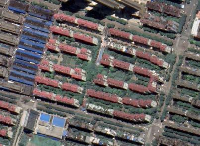
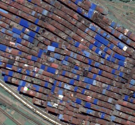
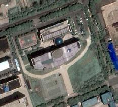
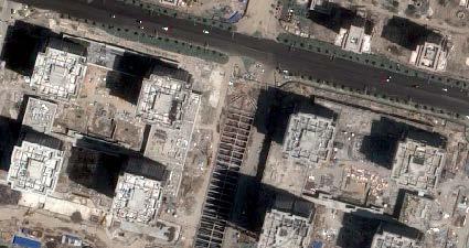
10 FROM URBAN LAND COVER TO LAND USE Define urban land use classes (a) high-density residential (b) low-density residential (c) commercial (f) industrial (d) public management-services (e) green space (g) undeveloped land (g) transportation 9
11 CHARACTERIZATION OF URBAN LAND USE Table 2: Commonly used land use indicators Indicators Land use unit - related Land cover - related Landscape metrics Description Basic geometrical features, e.g. area, perimeter, compactness, and shape index, with respect to land use units. The coverage ratio of a specific land cover class. The density of a specific land cover class. Fractal dimension. Landscape shape index. Shannon s diversity index. 10
12 SPATIAL ARRANGEMENT CHARACTERIZATION Spatial arrangement characterization considering the functional properties of buildings, referred to as building types. To characterize building types, we use the geometrical and morphological features of classified buildings (Li, et al. 2016). Create a morphological profile MMMM by a set of path openings MMMM xx = Π LL xx, LL 1,, LL max The building types are classified by an unsupervised method based on morphological and geometrical features. Li, M., Stein, A., Bijker, W., Zhan, Q., Region-based Urban Road Extraction from VHR Satellite Images Using Binary Partition Tree. International Journal of Applied Earth Observation and Geoinformation, 44,
 VHR image (b)")
 Directional")


13 RESULTS Directional features (a) VHR image (b) Extracted shadow (c) Fuzzy landscape (d) Directional features The brighter, the dir. relation is stronger, and the object is more likely being a building object. 12


14 RESULTS Not using dir. feature Using dir. feature 13
15 RESULTS Table 3: Pixel-based accuracy assessment for classified land cover. GR: grass, TR: tree, SH: shadow, WT: water, BS: bare soil, OT: others, UA: user accuracy, PA: producer accuracy, OA: overall accuracy, Kappa: kappa coefficient. % GR TR SH WT BS BD OT UA GR TR SH WT BS BD OT PA OA = 94.42, Kappa =


16 RESULTS Object-based accuracy assessment by geometric error indices. Object-based assessment Classified building Reference building Total error < 0.2 < 0.4 < 0.6 < 0.8 < 1.0 Reference building False positives 15

17 RESULTS CI PM RL CI 16
18 RESULTS Table 4: Accuracy assessment of the classified urban land use. RL: low-density residential, RH: high-density residential, GS: green space, UN: undeveloped land, PM: public management and service, CI: commercial and industrial, UA: user accuracy, PA: producer accuracy, OA: overall accuracy, Kappa: kappa coefficient. % RL RH GS UN PM CI UA RL RH GS UN PM CI PA OA = 75.00; Kappa =
19 CONCLUSIONS AND DISCUSSION Conclusions i. The directional relationships between buildings and their shadow can improve the distinguishability of buildings from other man-made land cover features. ii. When inferring urban land use from land cover, the spatial arrangement of urban land use can be characterized by quantifying the composition of buildings with different types. Discussion and future work i. To classify buildings to specific types and deal with the associated uncertainties. ii. To investigate the transferability of the proposed method to different urban landscapes, e.g. a study area in Oklahoma, US, or to big datasets. iii. To apply or extend the proposed method for VHR stereo-images. 18
20 Thank you!
Classification of High Spatial Resolution Remote Sensing Images Based on Decision Fusion
 Journal of Advances in Information Technology Vol. 8, No. 1, February 2017 Classification of High Spatial Resolution Remote Sensing Images Based on Decision Fusion Guizhou Wang Institute of Remote Sensing
COMPARISON OF PIXEL-BASED AND OBJECT-BASED CLASSIFICATION METHODS FOR SEPARATION OF CROP PATTERNS
 COMPARISON OF PIXEL-BASED AND OBJECT-BASED CLASSIFICATION METHODS FOR SEPARATION OF CROP PATTERNS Levent BAŞAYİĞİT, Rabia ERSAN Suleyman Demirel University, Agriculture Faculty, Soil Science and Plant
HIERARCHICAL IMAGE OBJECT-BASED STRUCTURAL ANALYSIS TOWARD URBAN LAND USE CLASSIFICATION USING HIGH-RESOLUTION IMAGERY AND AIRBORNE LIDAR DATA
 HIERARCHICAL IMAGE OBJECT-BASED STRUCTURAL ANALYSIS TOWARD URBAN LAND USE CLASSIFICATION USING HIGH-RESOLUTION IMAGERY AND AIRBORNE LIDAR DATA Qingming ZHAN, Martien MOLENAAR & Klaus TEMPFLI International
AN INVESTIGATION OF AUTOMATIC CHANGE DETECTION FOR TOPOGRAPHIC MAP UPDATING
 AN INVESTIGATION OF AUTOMATIC CHANGE DETECTION FOR TOPOGRAPHIC MAP UPDATING Patricia Duncan 1 & Julian Smit 2 1 The Chief Directorate: National Geospatial Information, Department of Rural Development and
A COMPARISON BETWEEN DIFFERENT PIXEL-BASED CLASSIFICATION METHODS OVER URBAN AREA USING VERY HIGH RESOLUTION DATA INTRODUCTION
 A COMPARISON BETWEEN DIFFERENT PIXEL-BASED CLASSIFICATION METHODS OVER URBAN AREA USING VERY HIGH RESOLUTION DATA Ebrahim Taherzadeh a, Helmi Z.M. Shafri a, Seyed Hassan Khalifeh Soltani b, Shattri Mansor
Object-based feature extraction of Google Earth Imagery for mapping termite mounds in Bahia, Brazil
 OPEN ACCESS Conference Proceedings Paper Sensors and Applications www.mdpi.com/journal/sensors Object-based feature extraction of Google Earth Imagery for mapping termite mounds in Bahia, Brazil Sunhui
OBJECT BASED IMAGE ANALYSIS FOR URBAN MAPPING AND CITY PLANNING IN BELGIUM. P. Lemenkova
 Fig. 3 The fragment of 3D view of Tambov spatial model References 1. Nemtinov,V.A. Information technology in development of spatial-temporal models of the cultural heritage objects: monograph / V.A. Nemtinov,
URBAN LAND COVER AND LAND USE CLASSIFICATION USING HIGH SPATIAL RESOLUTION IMAGES AND SPATIAL METRICS
 URBAN LAND COVER AND LAND USE CLASSIFICATION USING HIGH SPATIAL RESOLUTION IMAGES AND SPATIAL METRICS Ivan Lizarazo Universidad Distrital, Department of Cadastral Engineering, Bogota, Colombia; ilizarazo@udistrital.edu.co
Sub-pixel regional land cover mapping. with MERIS imagery
 Sub-pixel regional land cover mapping with MERIS imagery R. Zurita Milla, J.G.P.W. Clevers and M. E. Schaepman Centre for Geo-information Wageningen University 29th September 2005 Overview Land Cover MERIS
GeoComputation 2011 Session 4: Posters Accuracy assessment for Fuzzy classification in Tripoli, Libya Abdulhakim khmag, Alexis Comber, Peter Fisher ¹D
 Accuracy assessment for Fuzzy classification in Tripoli, Libya Abdulhakim khmag, Alexis Comber, Peter Fisher ¹Department of Geography, University of Leicester, Leicester, LE 7RH, UK Tel. 446252548 Email:
A DATA FIELD METHOD FOR URBAN REMOTELY SENSED IMAGERY CLASSIFICATION CONSIDERING SPATIAL CORRELATION
 The International Archives of the Photogrammetry, Remote Sensing and Spatial Information Sciences, Volume XLI-B7, 016 XXIII ISPRS Congress, 1 19 July 016, Prague, Czech Republic A DATA FIELD METHOD FOR
IMPROVING REMOTE SENSING-DERIVED LAND USE/LAND COVER CLASSIFICATION WITH THE AID OF SPATIAL INFORMATION
 IMPROVING REMOTE SENSING-DERIVED LAND USE/LAND COVER CLASSIFICATION WITH THE AID OF SPATIAL INFORMATION Yingchun Zhou1, Sunil Narumalani1, Dennis E. Jelinski2 Department of Geography, University of Nebraska,
Remote sensing of sealed surfaces and its potential for monitoring and modeling of urban dynamics
 Remote sensing of sealed surfaces and its potential for monitoring and modeling of urban dynamics Frank Canters CGIS Research Group, Department of Geography Vrije Universiteit Brussel Herhaling titel van
ANALYSING THE DIVERSITY OF DEPRIVED AREAS IN MUMBAI, INDIA
 ANALYSING THE DIVERSITY OF DEPRIVED AREAS IN MUMBAI, INDIA MONIKA KUFFER (M.KUFFER@UTWENTE.NL) KARIN PFEFFER, RICHARD SLIUZAS, ISA BAUD, MARTIN VAN MAARSEVEEN Source: Google Earth CONTENT OF PRESENTATION
The Road to Data in Baltimore
 Creating a parcel level database from high resolution imagery By Austin Troy and Weiqi Zhou University of Vermont, Rubenstein School of Natural Resources State and local planning agencies are increasingly
KNOWLEDGE-BASED CLASSIFICATION OF LAND COVER FOR THE QUALITY ASSESSEMENT OF GIS DATABASE. Israel -
 KNOWLEDGE-BASED CLASSIFICATION OF LAND COVER FOR THE QUALITY ASSESSEMENT OF GIS DATABASE Ammatzia Peled a,*, Michael Gilichinsky b a University of Haifa, Department of Geography and Environmental Studies,
FINDING SPATIAL UNITS FOR LAND USE CLASSIFICATION BASED ON HIERARCHICAL IMAGE OBJECTS
 ISPRS SIPT IGU UCI CIG ACSG Table of contents Table des matières Authors index Index des auteurs Search Recherches Exit Sortir FINDING SPATIAL UNITS FOR LAND USE CLASSIFICATION BASED ON HIERARCHICAL IMAGE
An Automated Object-Oriented Satellite Image Classification Method Integrating the FAO Land Cover Classification System (LCCS).
.") An Automated Object-Oriented Satellite Image Classification Method Integrating the FAO Land Cover Classification System (LCCS). Ruvimbo Gamanya Sibanda Prof. Dr. Philippe De Maeyer Prof. Dr. Morgan De
An Automated Object-Oriented Satellite Image Classification Method Integrating the FAO Land Cover Classification System (LCCS). Ruvimbo Gamanya Sibanda Prof. Dr. Philippe De Maeyer Prof. Dr. Morgan De
Outline: Introduction - Data used - Methods - Results
 Mapping of land covers in South Greenland using very high resolution satellite imagery Menaka Chellasamy, Mateja Ogric, Mogens H. Greve and René Larsen Outline: Introduction - Data used - Methods - Results
Joint International Mechanical, Electronic and Information Technology Conference (JIMET 2015)
") Joint International Mechanical, Electronic and Information Technology Conference (JIMET 2015) Extracting Land Cover Change Information by using Raster Image and Vector Data Synergy Processing Methods Tao
Joint International Mechanical, Electronic and Information Technology Conference (JIMET 2015) Extracting Land Cover Change Information by using Raster Image and Vector Data Synergy Processing Methods Tao
GIS GIS.
 Vol.7, No. 1, Spring 2015 Iranian Remote Sensing & - * Email: Hamid.hansar@Gmail.com * (Wang, 1990) (Liu et al., 2011) (Liu et al., 2011) (Rajesh et al., 2015) - Melgani et al., 2000 (Liu et al., 2011)
Object-based classification of residential land use within Accra, Ghana based on QuickBird satellite data
 International Journal of Remote Sensing Vol. 28, No. 22, 20 November 2007, 5167 5173 Letter Object-based classification of residential land use within Accra, Ghana based on QuickBird satellite data D.
AN INTEGRATED METHOD FOR FOREST CANOPY COVER MAPPING USING LANDSAT ETM+ IMAGERY INTRODUCTION
 AN INTEGRATED METHOD FOR FOREST CANOPY COVER MAPPING USING LANDSAT ETM+ IMAGERY Zhongwu Wang, Remote Sensing Analyst Andrew Brenner, General Manager Sanborn Map Company 455 E. Eisenhower Parkway, Suite
Object Based Land Cover Extraction Using Open Source Software
 Object Based Land Cover Extraction Using Open Source Software Abhasha Joshi 1, Janak Raj Joshi 2, Nawaraj Shrestha 3, Saroj Sreshtha 4, Sudarshan Gautam 5 1 Instructor, Land Management Training Center,
Preparation of LULC map from GE images for GIS based Urban Hydrological Modeling
 International Conference on Modeling Tools for Sustainable Water Resources Management Department of Civil Engineering, Indian Institute of Technology Hyderabad: 28-29 December 2014 Abstract Preparation
Hyperspectral image classification using Support Vector Machine
 Journal of Physics: Conference Series OPEN ACCESS Hyperspectral image classification using Support Vector Machine To cite this article: T A Moughal 2013 J. Phys.: Conf. Ser. 439 012042 View the article
Object-based land use/cover extraction from QuickBird image using Decision tree
 Object-based land use/cover extraction from QuickBird image using Decision tree Eltahir. M. Elhadi. 12, Nagi. Zomrawi 2 1-China University of Geosciences Faculty of Resources, Wuhan, 430074, China, 2-Sudan
Urban remote sensing: from local to global and back
 Urban remote sensing: from local to global and back Paolo Gamba University of Pavia, Italy A few words about Pavia Historical University (1361) in a nice town slide 3 Geoscience and Remote Sensing Society
West meets East: Monitoring and modeling urbanization in China Land Cover-Land Use Change Program Science Team Meeting April 3, 2012
 West meets East: Monitoring and modeling urbanization in China Land Cover-Land Use Change Program Science Team Meeting April 3, 2012 Annemarie Schneider Center for Sustainability and the Global Environment,
High resolution wetland mapping I.
 High resolution wetland mapping I. Based on the teaching material developed by Steve Kas, GeoVille for WOIS Product Group #5 Dr. Zoltán Vekerdy and János Grósz z.vekerdy@utwente.nl vekerdy.zoltan@mkk.szie.hu
DEPENDENCE OF URBAN TEMPERATURE ELEVATION ON LAND COVER TYPES. Ping CHEN, Soo Chin LIEW and Leong Keong KWOH
 DEPENDENCE OF URBAN TEMPERATURE ELEVATION ON LAND COVER TYPES Ping CHEN, Soo Chin LIEW and Leong Keong KWOH Centre for Remote Imaging, Sensing and Processing, National University of Singapore, Lower Kent
MAPPING LAND COVER TYPES FROM VERY HIGH SPATIAL RESOLUTION IMAGERY: AUTOMATIC APPLICATION OF AN OBJECT BASED CLASSIFICATION SCHEME
 MAPPING LAND COVER TYPES FROM VERY HIGH SPATIAL RESOLUTION IMAGERY: AUTOMATIC APPLICATION OF AN OBJECT BASED CLASSIFICATION SCHEME Lara A Arroyo 1,2,3*, Kasper Johansen 1,2, Stuart Phinn 1,2 1 Joint Remote
Land Use/Cover Change Detection Using Feature Database Based on Vector-Image Data Conflation
 Proceedings of the 8th International Symposium on Spatial Accuracy Assessment in Natural Resources and Environmental Sciences Shanghai, P. R. China, June 25-27, 2008, pp. 255-262 Land Use/Cover Change
Applications of GIS and Remote Sensing for Analysis of Urban Heat Island
 Chuanxin Zhu Professor Peter V. August Professor Yeqiao Wang NRS 509 December 15, 2016 Applications of GIS and Remote Sensing for Analysis of Urban Heat Island Since the last century, the global mean surface
The Self-adaptive Adjustment Method of Clustering Center in Multi-spectral Remote Sensing Image Classification of Land Use
 The Self-adaptive Adjustment Method of Clustering Center in Multi-spectral Remote Sensing Image Classification of Land Use Shujing Wan 1,Chengming Zhang(*) 1,2, Jiping Liu 2, Yong Wang 2, Hui Tian 1, Yong
PRINCIPLES OF PHOTO INTERPRETATION
 PRINCIPLES OF PHOTO INTERPRETATION Photo Interpretation the act of examining photographic images for the purpose of identifying objects and judging their significance an art more than a science Recognition
Application of Topology to Complex Object Identification. Eliseo CLEMENTINI University of L Aquila
 Application of Topology to Complex Object Identification Eliseo CLEMENTINI University of L Aquila Agenda Recognition of complex objects in ortophotos Some use cases Complex objects definition An ontology
LAND USE CLASSIFICATION USING CONDITIONAL RANDOM FIELDS FOR THE VERIFICATION OF GEOSPATIAL DATABASES
 LAND USE CLASSIFICATION USING CONDITIONAL RANDOM FIELDS FOR THE VERIFICATION OF GEOSPATIAL DATABASES L. Albert *, F. Rottensteiner, C. Heipke Institute of Photogrammetry and GeoInformation, Leibniz Universität
The Attribute Accuracy Assessment of Land Cover Data in the National Geographic Conditions Survey
 The Attribute Accuracy Assessment of Land Cover Data in the National Geographic Conditions Survey Xiaole Ji a, *, Xiao Niu a Shandong Provincial Institute of Land Surveying and Mapping Jinan, Shandong
Automated algorithms for extracting urban features from Ikonos satellite data. A case study in New York City.
 Automated algorithms for extracting urban features from Ikonos satellite data. A case study in New York City. SUNIL BHASKARAN Department of Earth and Physical Sciences, Bronx Community College, York College
Photogrammetry and Remote Sensing Beyond the Centenary
 Photogrammetry and Remote Sensing Beyond the Centenary Norbert Pfeifer Vienna University of Technology Institute of Photogrammetry and Remote Sensing I.P.F. Statements Photogrammetry is completed Professor
Urban Tree Canopy Assessment Purcellville, Virginia
 GLOBAL ECOSYSTEM CENTER www.systemecology.org Urban Tree Canopy Assessment Purcellville, Virginia Table of Contents 1. Project Background 2. Project Goal 3. Assessment Procedure 4. Economic Benefits 5.
Fundamentals of Photographic Interpretation
 Principals and Elements of Image Interpretation Fundamentals of Photographic Interpretation Observation and inference depend on interpreter s training, experience, bias, natural visual and analytical abilities.
Land Surface Processes and Land Use Change. Lex Comber
 Land Surface Processes and Land Use Change Lex Comber ajc36@le.ac.uk Land Surface Processes and Land Use Change Geographic objects in GIS databases Detecting land use change using multitemporal imaging
USING LANDSAT IN A GIS WORLD
 USING LANDSAT IN A GIS WORLD RACHEL MK HEADLEY; PHD, PMP STEM LIAISON, ACADEMIC AFFAIRS BLACK HILLS STATE UNIVERSITY This material is based upon work supported by the National Science Foundation under
Principles of Pattern Recognition. C. A. Murthy Machine Intelligence Unit Indian Statistical Institute Kolkata
 Principles of Pattern Recognition C. A. Murthy Machine Intelligence Unit Indian Statistical Institute Kolkata e-mail: murthy@isical.ac.in Pattern Recognition Measurement Space > Feature Space >Decision
Building a validation database for land cover products from high spatial resolution images
 Building a validation database for land cover products from high spatial resolution images The Land Cover project of the ESA Climate Change Initiative Bontemps Sophie 1, Achard Frédéric 2, Lamarche Céline
Comparison between Land Surface Temperature Retrieval Using Classification Based Emissivity and NDVI Based Emissivity
 Comparison between Land Surface Temperature Retrieval Using Classification Based Emissivity and NDVI Based Emissivity Isabel C. Perez Hoyos NOAA Crest, City College of New York, CUNY, 160 Convent Avenue,
CNES R&D and available software for Space Images based risk and disaster management
 CNES R&D and available software for Space Images based risk and disaster management 1/21 Contributors: CNES (Centre National d Etudes Spatiales), Toulouse, France Hélène Vadon Jordi Inglada 2/21 Content
Geoscape Capturing Australia s Built Environment for emergency modelling and management. Dan Paull Chief Executive Officer PSMA Australia
 Geoscape Capturing Australia s Built Environment for emergency modelling and management Dan Paull Chief Executive Officer PSMA Australia There is no wealth like knowledge, and no poverty like ignorance.
A Method to Improve the Accuracy of Remote Sensing Data Classification by Exploiting the Multi-Scale Properties in the Scene
 Proceedings of the 8th International Symposium on Spatial Accuracy Assessment in Natural Resources and Environmental Sciences Shanghai, P. R. China, June 25-27, 2008, pp. 183-188 A Method to Improve the
Cloud analysis from METEOSAT data using image segmentation for climate model verification
 Cloud analysis from METEOSAT data using image segmentation for climate model verification R. Huckle 1, F. Olesen 2 Institut für Meteorologie und Klimaforschung, 1 University of Karlsruhe, 2 Forschungszentrum
Principals and Elements of Image Interpretation
 Principals and Elements of Image Interpretation 1 Fundamentals of Photographic Interpretation Observation and inference depend on interpreter s training, experience, bias, natural visual and analytical
2 States and European space agencies. In recent years, China has launched a series of high-resolution satellites among which ZY-1 02C is one of the mo
 Journal of Zhejiang University-SCIENCE C (Computers & Electronics) ISSN 1869-1951 (Print); ISSN 1869-196X (Online) www.zju.edu.cn/jzus; www.springerlink.com E-mail: jzus@zju.edu.cn Ma et al. / J Zhejiang
Article Classification of Ultra-High Resolution Orthophotos Combined with DSM Using a Dual Morphological Top Hat Profile
 Article Classification of Ultra-High Resolution Orthophotos Combined with DSM Using a Dual Morphological Top Hat Profile Qian Zhang 1, Rongjun Qin 2, Xin Huang 3, Yong Fang 1, * and Liang Liu 1 Received:
Application of ZY-3 remote sensing image in the research of Huashan experimental watershed
 Remote Sensing and GIS for Hydrology and Water Resources (IAHS Publ. 368, 2015) (Proceedings RSHS14 and ICGRHWE14, Guangzhou, China, August 2014). 51 Application of ZY-3 remote sensing image in the research
Temporal and spatial approaches for land cover classification.
 Temporal and spatial approaches for land cover classification. Ryabukhin Sergey sergeyryabukhin@gmail.com Abstract. This paper describes solution for Time Series Land Cover Classification Challenge (TiSeLaC).
1st EARSeL Workshop of the SIG Urban Remote Sensing Humboldt-Universität zu Berlin, 2-3 March 2006
 1 AN URBAN CLASSIFICATION APPROACH BASED ON AN OBJECT ORIENTED ANALYSIS OF HIGH RESOLUTION SATELLITE IMAGERY FOR A SPATIAL STRUCTURING WITHIN URBAN AREAS Hannes Taubenböck, Thomas Esch, Achim Roth German
Land Cover Classification Over Penang Island, Malaysia Using SPOT Data
 Land Cover Classification Over Penang Island, Malaysia Using SPOT Data School of Physics, Universiti Sains Malaysia, 11800 Penang, Malaysia. Tel: +604-6533663, Fax: +604-6579150 E-mail: hslim@usm.my, mjafri@usm.my,
High resolution mapping of urban areas using SPOT-5 images and ancillary data
 International Journal of Environment and Geoinformatics 2(2), 63-76 (2015) High resolution mapping of urban areas using SPOT-5 images and ancillary data Elif Sertel 1*, Semih Sami Akay 2 1 Istanbul Technical
Page 1 of 8 of Pontius and Li
 ESTIMATING THE LAND TRANSITION MATRIX BASED ON ERRONEOUS MAPS Robert Gilmore Pontius r 1 and Xiaoxiao Li 2 1 Clark University, Department of International Development, Community and Environment 2 Purdue
A VECTOR AGENT APPROACH TO EXTRACT THE BOUNDARIES OF REAL-WORLD PHENOMENA FROM SATELLITE IMAGES
 A VECTOR AGENT APPROACH TO EXTRACT THE BOUNDARIES OF REAL-WORLD PHENOMENA FROM SATELLITE IMAGES Kambiz Borna, Antoni Moore & Pascal Sirguey School of Surveying University of Otago. Dunedin, New Zealand
Land cover classification of QuickBird multispectral data with an object-oriented approach
 Land cover classification of QuickBird multispectral data with an object-oriented approach E. Tarantino Polytechnic University of Bari, Italy Abstract Recent satellite technologies have produced new data
APPLICATION OF REMOTE SENSING IN LAND USE CHANGE PATTERN IN DA NANG CITY, VIETNAM
 APPLICATION OF REMOTE SENSING IN LAND USE CHANGE PATTERN IN DA NANG CITY, VIETNAM Tran Thi An 1 and Vu Anh Tuan 2 1 Department of Geography - Danang University of Education 41 Le Duan, Danang, Vietnam
Spectral and Spatial Methods for the Classification of Urban Remote Sensing Data
 Spectral and Spatial Methods for the Classification of Urban Remote Sensing Data Mathieu Fauvel gipsa-lab/dis, Grenoble Institute of Technology - INPG - FRANCE Department of Electrical and Computer Engineering,
Object-Based Land Cover Classification Using High-Posting-Density LiDAR Data
 Object-Based Land Cover Classification Using High-Posting-Density LiDAR Data Jungho Im 1 Environmental Resources and Forest Engineering, State University of New York, College of Environmental Sciences
Potential Open Space Detection and Decision Support for Urban Planning by Means of Optical VHR Satellite Imagery
 Remote Sensing and Geoinformation Lena Halounová, Editor not only for Scientific Cooperation EARSeL, 2011 Potential Open Space Detection and Decision Support for Urban Planning by Means of Optical VHR
Assessment of spatial analysis techniques for estimating impervious cover
 University of Wollongong Research Online Faculty of Engineering - Papers (Archive) Faculty of Engineering and Information Sciences 2006 Assessment of spatial analysis techniques for estimating impervious
AUTOMATED BUILDING DETECTION FROM HIGH-RESOLUTION SATELLITE IMAGE FOR UPDATING GIS BUILDING INVENTORY DATA
 13th World Conference on Earthquake Engineering Vancouver, B.C., Canada August 1-6, 2004 Paper No. 678 AUTOMATED BUILDING DETECTION FROM HIGH-RESOLUTION SATELLITE IMAGE FOR UPDATING GIS BUILDING INVENTORY
Globally Estimating the Population Characteristics of Small Geographic Areas. Tom Fitzwater
 Globally Estimating the Population Characteristics of Small Geographic Areas Tom Fitzwater U.S. Census Bureau Population Division What we know 2 Where do people live? Difficult to measure and quantify.
Urban structure types as a fingerprints of past, present and future city development
 Urban structure types as a fingerprints of past, present and future city development Jaros law Jasiewicz and Adam D abrowski Institute of Geoecology and Geoinformation, Adam Mickiewicz University in Poznań,
Using MERIS and MODIS for Land Cover Mapping in the Netherlands
 Using MERIS and for Land Cover Mapping in the Netherlands Raul Zurita Milla, Michael Schaepman and Jan Clevers Wageningen University, Centre for Geo-Information, NL Introduction Actual and reliable information
Remote Sensing the Urban Landscape
 Remote Sensing the Urban Landscape Urban landscape are composed of a diverse assemblage of materials (concrete, asphalt, metal, plastic, shingles, glass, water, grass, shrubbery, trees, and soil) arranged
Geographically weighted methods for examining the spatial variation in land cover accuracy
 Geographically weighted methods for examining the spatial variation in land cover accuracy Alexis Comber 1, Peter Fisher 1, Chris Brunsdon 2, Abdulhakim Khmag 1 1 Department of Geography, University of
Object Oriented Classification Using High-Resolution Satellite Images for HNV Farmland Identification. Shafique Matin and Stuart Green
 Object Oriented Classification Using High-Resolution Satellite Images for HNV Farmland Identification Shafique Matin and Stuart Green REDP, Teagasc Ashtown, Dublin, Ireland Correspondence: shafique.matin@teagasc.ie
International Journal of Remote Sensing, in press, 2006.
 International Journal of Remote Sensing, in press, 2006. Parameter Selection for Region-Growing Image Segmentation Algorithms using Spatial Autocorrelation G. M. ESPINDOLA, G. CAMARA*, I. A. REIS, L. S.
USING GIS CARTOGRAPHIC MODELING TO ANALYSIS SPATIAL DISTRIBUTION OF LANDSLIDE SENSITIVE AREAS IN YANGMINGSHAN NATIONAL PARK, TAIWAN
 CO-145 USING GIS CARTOGRAPHIC MODELING TO ANALYSIS SPATIAL DISTRIBUTION OF LANDSLIDE SENSITIVE AREAS IN YANGMINGSHAN NATIONAL PARK, TAIWAN DING Y.C. Chinese Culture University., TAIPEI, TAIWAN, PROVINCE
Using geographically weighted variables for image classification
 Remote Sensing Letters Vol. 3, No. 6, November 2012, 491 499 Using geographically weighted variables for image classification BRIAN JOHNSON*, RYUTARO TATEISHI and ZHIXIAO XIE Department of Geosciences,
IEEE TRANSACTIONS ON GEOSCIENCE AND REMOTE SENSING 1
 IEEE TRANSACTIONS ON GEOSCIENCE AND REMOTE SENSING 1 A Novel Automatic Change Detection Method for Urban High-Resolution Remotely Sensed Imagery Based on Multiindex Scene Representation Dawei Wen, Xin
DEVELOPMENT OF DIGITAL CARTOGRAPHIC DATABASE FOR MANAGING THE ENVIRONMENT AND NATURAL RESOURCES IN THE REPUBLIC OF SERBIA
 DEVELOPMENT OF DIGITAL CARTOGRAPHIC BASE FOR MANAGING THE ENVIRONMENT AND NATURAL RESOURCES IN THE REPUBLIC OF SERBIA Dragutin Protic, Ivan Nestorov Institute for Geodesy, Faculty of Civil Engineering,
EFFECT OF ANCILLARY DATA ON THE PERFORMANCE OF LAND COVER CLASSIFICATION USING A NEURAL NETWORK MODEL. Duong Dang KHOI.
 EFFECT OF ANCILLARY DATA ON THE PERFORMANCE OF LAND COVER CLASSIFICATION USING A NEURAL NETWORK MODEL Duong Dang KHOI 1 10 Feb, 2011 Presentation contents 1. Introduction 2. Methods 3. Results 4. Discussion
IAPRS, Vol. XXXIII, Amsterdam, 2000 THE CONTRIBUTION OF GIS AND REMOTE SENSING IN URBAN LAND USE NEGOTIATION IN DEVELOPING COUNTRIES
 THE CONTRIBUTION OF GIS AND REMOTE SENSING IN URBAN LAND USE NEGOTIATION IN DEVELOPING COUNTRIES Faith KARANJA*and Peter LOHMANN** University of Hannover Institute of Photogrammetry and Engineering Surveys(IPI)
This is trial version
 Journal of Rangeland Science, 2012, Vol. 2, No. 2 J. Barkhordari and T. Vardanian/ 459 Contents available at ISC and SID Journal homepage: www.rangeland.ir Full Paper Article: Using Post-Classification
NASA EARTH EXCHANGE (NEX)
") NASA EARTH EXCHANGE (NEX) Enabling Interdisciplinary Research nex.nasa.gov Uttam Kumar and Ramakrishna Nemani NASA Ames Research Center, Moffett Field, CA. The need for collaborative research - NEX Massive
NASA EARTH EXCHANGE (NEX) Enabling Interdisciplinary Research nex.nasa.gov Uttam Kumar and Ramakrishna Nemani NASA Ames Research Center, Moffett Field, CA. The need for collaborative research - NEX Massive
Contemporary Data Collection and Spatial Information Management Techniques to support Good Land Policies
 Contemporary Data Collection and Spatial Information Management Techniques to support Good Land Policies Ch. Ioannidis Associate Professor FIG Commission 3 Workshop Paris, 25-28 October 2011 Introduction
Change Detection Analysis By Using Ikonos And Quick Bird Imageries
 Change Detection Analysis By Using Ikonos And Quick Bird Imageries Eltahir Mohamed Elhadi 12 and Nagi Zomrawi 2 1-China University of Geosciences Faculty of Resources, Wuhan, 430074, China, 2-Sudan University
USE OF RADIOMETRICS IN SOIL SURVEY
 USE OF RADIOMETRICS IN SOIL SURVEY Brian Tunstall 2003 Abstract The objectives and requirements with soil mapping are summarised. The capacities for different methods to address these objectives and requirements
DETECTING HUMAN ACTIVITIES IN THE ARCTIC OCEAN BY CONSTRUCTING AND ANALYZING SUPER-RESOLUTION IMAGES FROM MODIS DATA INTRODUCTION
 DETECTING HUMAN ACTIVITIES IN THE ARCTIC OCEAN BY CONSTRUCTING AND ANALYZING SUPER-RESOLUTION IMAGES FROM MODIS DATA Shizhi Chen and YingLi Tian Department of Electrical Engineering The City College of
Urban areas & climate change
 Urban areas & climate change Paolo Gamba University of Pavia University of Pavia The UNIPV TLC & RS Lab is a dynamic research group developing in the past years many techniques devoted to the analysis
GEOG 4110/5100 Advanced Remote Sensing Lecture 12. Classification (Supervised and Unsupervised) Richards: 6.1, ,
 Richards: 6.1, ,") GEOG 4110/5100 Advanced Remote Sensing Lecture 12 Classification (Supervised and Unsupervised) Richards: 6.1, 8.1-8.8.2, 9.1-9.34 GEOG 4110/5100 1 Fourier Transforms Transformations in the Frequency Domain
GEOG 4110/5100 Advanced Remote Sensing Lecture 12 Classification (Supervised and Unsupervised) Richards: 6.1, 8.1-8.8.2, 9.1-9.34 GEOG 4110/5100 1 Fourier Transforms Transformations in the Frequency Domain
URBAN MAPPING AND CHANGE DETECTION
 URBAN MAPPING AND CHANGE DETECTION Sebastian van der Linden with contributions from Akpona Okujeni Humboldt-Unveristät zu Berlin, Germany Introduction Introduction The urban millennium Source: United Nations,
APPLICATIONS SENSING IN THE STUDY OF URBANIZATION OF REMOTE. Submitted by: Bryan Wong. Tonya Smith. Anna Yuill. Sebastian Kallos
 APPLICATIONS OF REMOTE SENSING IN THE STUDY OF URBANIZATION Image provided by Nasa Submitted by: Bryan Wong Tonya Smith Anna Yuill Sebastian Kallos FRST 443: Remote Sensing for Forestry and Agriculture
Change Detection Analysis By Using Ikonos And Quick Bird Imageries
 Change Detection Analysis By Using Ikonos And Quick Bird Imageries Eltahir. M. Elhadi. 12, Nagi. Zomrawi 2 1-China University of Geosciences Faculty of Resources, Wuhan, 430074, China, 2-Sudan University
Article Capturing the Diversity of Deprived Areas with Image-Based Features: The Case of Mumbai
 Article Capturing the Diversity of Deprived Areas with Image-Based Features: The Case of Mumbai Monika Kuffer 1, *, Karin Pfeffer 2, Richard Sliuzas 1, Isa Baud 2 and Martin van Maarseveen 1 1 Faculty
Proceedings Combining Water Indices for Water and Background Threshold in Landsat Image
 Proceedings Combining Water Indices for Water and Background Threshold in Landsat Image Tri Dev Acharya 1, Anoj Subedi 2, In Tae Yang 1 and Dong Ha Lee 1, * 1 Department of Civil Engineering, Kangwon National
Urban Mapping & Change Detection. Sebastian van der Linden Humboldt-Universität zu Berlin, Germany
 Urban Mapping & Change Detection Sebastian van der Linden Humboldt-Universität zu Berlin, Germany Introduction - The urban millennium Source: United Nations Introduction Text Source: Google Earth Introduction
LAND USE AND LAND COVER CHANGES AND URBAN SPRAWL IN RIYADH, SAUDI ARABIA: AN ANALYSIS USING MULTI-TEMPORAL LANDSAT DATA AND SHANNON'S ENTROPY INDEX
 LAND USE AND LAND COVER CHANGES AND URBAN SPRAWL IN RIYADH, SAUDI ARABIA: AN ANALYSIS USING MULTI-TEMPORAL LANDSAT DATA AND SHANNON'S ENTROPY INDEX M. T. Rahman a a King Fahd University of Petroleum and
Dynamic Expansion and Urbanization of Greater Cairo Metropolis, Egypt Ahmed Abdelhalim M. Hassan
 Ahmed Abdelhalim M. Hassan (MSc Ahmed Abdelhalim M. Hassan, Institue of Landscape Ecology, Muenster University, Robert-Koch Straße 28, D-48149 Münster, Germany, ahmedahalim@uni-muenster.de) 1 ABSTRACT
LAND COVER CATEGORY DEFINITION BY IMAGE INVARIANTS FOR AUTOMATED CLASSIFICATION
 LAND COVER CATEGORY DEFINITION BY IMAGE INVARIANTS FOR AUTOMATED CLASSIFICATION Nguyen Dinh Duong Environmental Remote Sensing Laboratory Institute of Geography Hoang Quoc Viet Rd., Cau Giay, Hanoi, Vietnam
CHAPTER-7 INTERFEROMETRIC ANALYSIS OF SPACEBORNE ENVISAT-ASAR DATA FOR VEGETATION CLASSIFICATION
 147 CHAPTER-7 INTERFEROMETRIC ANALYSIS OF SPACEBORNE ENVISAT-ASAR DATA FOR VEGETATION CLASSIFICATION 7.1 INTRODUCTION: Interferometric synthetic aperture radar (InSAR) is a rapidly evolving SAR remote