A VECTOR AGENT APPROACH TO EXTRACT THE BOUNDARIES OF REAL-WORLD PHENOMENA FROM SATELLITE IMAGES
|
|
|
- Edgar Bryant
- 6 years ago
- Views:
Transcription


1 A VECTOR AGENT APPROACH TO EXTRACT THE BOUNDARIES OF REAL-WORLD PHENOMENA FROM SATELLITE IMAGES Kambiz Borna, Antoni Moore & Pascal Sirguey School of Surveying University of Otago. Dunedin, New Zealand


2 1.1. Image Classification What is the image classification?


3 1.2. Methods A. Pixel-based: based on spectral reflectance Supervised Classification Unsupervised Classification


4 1.2. Methods The limitations of the pixel based classification A B Based on slide by Jarlath O Neil Dunne by Austin Troy and Weiqi Zhou, 2008
5 1.2. Methods B. Object-based classification: based on image object Image-objects are groups of connected pixels that are supposed to depict a homogeneous thematic meaning.


6 1.2. Methods B C compactness cpt l n Based on slide by Jarlath O Neil Dunne by Austin Troy and Weiqi Zhou, 2008


7 1.2. OBC Process Object-based image classification process Image segmentation Image Classification That means The objects remain unchanged once they are created Image objects have no direct relationship to real-world objects

8 1.3. Limitations may we have a correct extraction and shaping of interest objects
9 Proposed Method They are objects which can support a dynamic and irregular geometry: Geographical Vector Agents (VA) Moore et al. (2011)
10 3. 1. Image Object Geometry in The Context of The Vector Agent


11 3.2. Image Objects Construction and Evolution Rules Image object is automatically formed as a point in the pixel centre A new point along four cardinal directions by a constant distance that is specified by cell size

12 4. Implementation Based on a synthetic image : the growing process of two agent without negotiation

13 4. Implementation Case1: negotiation between two vector agents including shrinking and growing process.
14 4. Implementation Case 2: negotiation between two vector agents including splitting process.
15 4. Implementation Case 3: negotiation between two vector agents including joining process.

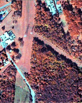
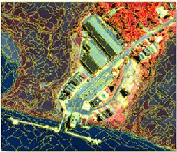
16 4. Implementation Case 4: VAs are the goal oriented objects. Here, they are initially defined to find the water and shadow. Water object eventually appears to be less likely than shadow and VA merges under a single shadow object Ikonos satellite image

17 4. Implementation a b c Case 5: VAs can use ancillary layer. E.g., the sample regions including a, b and c have similar spectral reflectance, yet they have different elevations. The same spectral reflectance but in different level based on a DEM layer


18 4.1. Summary This research has highlighted some abilities of the VA to support a dynamic geometry to image classification. Thank you for your attention
19 References: Baatz, M. and Scha pe, A. (2000). Multiresolution segmentation: an optimization approach for high quality multiscale image segmentation. In: Strobl, J., Blaschke, T. (Eds.), Angewandte Geogr. Informationsverarbeitung, vol. XII. Wichmann,Heidelberg,pp Baatz, M., Hoffmann, C. and Willhauck, G. (2007). Object-Based Image Analysis: Spatial Concepts for Knowledge-Driven Remote Sensing, Springer, pp Benenson, I. and Torrens, P. (2004). Geosimulation Automata-Based Modelling of Urban Phenomena. England, Wiley. Benz, U.C., Hofmann, P.,Willhauck, G., Lingenfelder, I. and Heynen, M.(2004). Multi-resolution, object-oriented fuzzy analysis of remote sensing data for GIS-ready information. ISPRS J. Photogrammetry Remote Sensing 58, Carlos M. Fonseca and Peter J. Fleming (1995), Evolutionary Computation, Springer. Bian, L. (1997). Multiscale Nature of Spatial Data in Scaling up Environmental Models, in Scale in Remote Sensing and GIS, Quattrochi, D.A. and Goodchild,M.F.(Eds), Lewis, pp Hay, J., Blashke, T.,Marceau, J. and Bouchard, A.(2003). A comparison of three imageobject methods for the multiscale analysis of landscape structure. ISPRS Journal of Photogrammetry & Remote Sensing, 57, pp Hay, G.J., Castilla, G., Wulder, M.A. and Ruiz, J.R.(2005). An automated object-based approach for the multiscale image segmentation of forest scenes. International Journal of Applied Earth Observation and Geoinformation, 7, pp Hammam, Y., Moore, A., and Whigham, P.(2007). "The dynamic geometry of Geographical Vector Agents",Computers, Environment and Urban Systems, vol.31, no.5, pp Gao, J. (2009). Digital Analysis of Remotely Sensed Imagery, McGrow-Hill, pp Goodchild, M.(2001). Issues in spatially explicit modelling. In D. Parker, T. Berger & S. M. Manson(Eds.), Agent-based models of land-use and landcover change (pp ). Irvine. Manson, S.M., Sun, S. and Bonsal, D.(2012). Agent-Based Models of Geographical Systems,Springer,pp Manson, S. M.(2007). Does scale exist? An epistemological scale continuum for complex human environment systems, Geoforum, Accepted in press. Moore, A.(2011). Geographical Vector Agent Based Simulation for Agricultural Land Use Modelling, in Advanced GeoSimulation Models, Marceau,D. and Benenson, I. (Eds), pp MacEachren, A. M., Robinson, A., Hopper, S., Gardner, S., Murray, R., Gahegan, M., and Hetzler E.(2005). Visualizing Geospatial Information Uncertainty: What We Know and What We Need to Know, Cartography and Geographic Information Science, Vol. 32, No. 3, 2005, pp Rouff, C.A., Hinchey M., Rash. J, Truszkowski, W., and Gordon,S. D. (Eds). (2006). Agent Technology from a Formal Perspective, Springer. Tian, J. and Chen, D.M. (2007). International Journal of Remote Sensing, ISSN print/issn , online Taylor & Francis. Torrens, P., and Benenson, I.(2003). "Geographic Automata Systems", International Journal of Geographic Information Science, vol. 10, no.4, pp Walsh, S. J., Moody, A., Allen, T. R., and Brown, D.G.(1997). Scale Dependence of NDVI and Its Relationship to Mountainous Terrain, in Scale in Remote Sensing and GIS, Quattrochi, D.A. and Goodchild,M.F.(Eds), Lewis, pp Yuan, M., Goodchild, M. F., Cova, T. J. (2007), Towards a General Theory of Geographic Representation in GIS, International Journal of Geographic Information Science, Volume 21, Pages
Detecting Characteristic Scales of Slope Gradient
 Detecting Characteristic Scales of Slope Gradient Clemens EISANK and Lucian DRĂGUŢ Abstract Very high resolution (VHR) DEMs such as obtained from LiDAR (Light Detection And Ranging) often present too much
The Attribute Accuracy Assessment of Land Cover Data in the National Geographic Conditions Survey
 The Attribute Accuracy Assessment of Land Cover Data in the National Geographic Conditions Survey Xiaole Ji a, *, Xiao Niu a Shandong Provincial Institute of Land Surveying and Mapping Jinan, Shandong
Parameter selection for region-growing image segmentation algorithms using spatial autocorrelation
 International Journal of Remote Sensing Vol. 27, No. 14, 20 July 2006, 3035 3040 Parameter selection for region-growing image segmentation algorithms using spatial autocorrelation G. M. ESPINDOLA, G. CAMARA*,
KNOWLEDGE-BASED CLASSIFICATION OF LAND COVER FOR THE QUALITY ASSESSEMENT OF GIS DATABASE. Israel -
 KNOWLEDGE-BASED CLASSIFICATION OF LAND COVER FOR THE QUALITY ASSESSEMENT OF GIS DATABASE Ammatzia Peled a,*, Michael Gilichinsky b a University of Haifa, Department of Geography and Environmental Studies,
A MULTI-SCALE OBJECT-ORIENTED APPROACH TO THE CLASSIFICATION OF MULTI-SENSOR IMAGERY FOR MAPPING LAND COVER IN THE TOP END.
 A MULTI-SCALE OBJECT-ORIENTED APPROACH TO THE CLASSIFICATION OF MULTI-SENSOR IMAGERY FOR MAPPING LAND COVER IN THE TOP END. Tim Whiteside 1,2 Author affiliation: 1 Natural and Cultural Resource Management,
Land cover classification of QuickBird multispectral data with an object-oriented approach
 Land cover classification of QuickBird multispectral data with an object-oriented approach E. Tarantino Polytechnic University of Bari, Italy Abstract Recent satellite technologies have produced new data
Potential Open Space Detection and Decision Support for Urban Planning by Means of Optical VHR Satellite Imagery
 Remote Sensing and Geoinformation Lena Halounová, Editor not only for Scientific Cooperation EARSeL, 2011 Potential Open Space Detection and Decision Support for Urban Planning by Means of Optical VHR
A simple agricultural land use model implemented using Geographical Vector Agents (GVA)
") A simple agricultural land use model implemented using Geographical Vector Agents (GVA) A. B. Moore 1, Y. Hammam 2, P. A. Whigham 2 1 School of Surveying / 2 Department of Information Science, University
A simple agricultural land use model implemented using Geographical Vector Agents (GVA) A. B. Moore 1, Y. Hammam 2, P. A. Whigham 2 1 School of Surveying / 2 Department of Information Science, University
AUTOMATIC LAND-COVER CLASSIFICATION OF LANDSAT IMAGES USING FEATURE DATABASE IN A NETWORK
 AUTOMATIC LAND-COVER CLASSIFICATION OF LANDSAT IMAGES USING FEATURE DATABASE IN A NETWORK G. W. Yoon*, S. I. Cho, G. J. Chae, J. H. Park ETRI Telematics Research Group, Daejeon, Korea (gwyoon, chosi, cbase,
1st EARSeL Workshop of the SIG Urban Remote Sensing Humboldt-Universität zu Berlin, 2-3 March 2006
 1 AN URBAN CLASSIFICATION APPROACH BASED ON AN OBJECT ORIENTED ANALYSIS OF HIGH RESOLUTION SATELLITE IMAGERY FOR A SPATIAL STRUCTURING WITHIN URBAN AREAS Hannes Taubenböck, Thomas Esch, Achim Roth German
UNCERTAINTY AND ERRORS IN GIS
 Christos G. Karydas,, Dr. xkarydas@agro.auth.gr http://users.auth.gr/xkarydas Lab of Remote Sensing and GIS Director: Prof. N. Silleos School of Agriculture Aristotle University of Thessaloniki, GR 1 UNCERTAINTY
AN INVESTIGATION OF AUTOMATIC CHANGE DETECTION FOR TOPOGRAPHIC MAP UPDATING
 AN INVESTIGATION OF AUTOMATIC CHANGE DETECTION FOR TOPOGRAPHIC MAP UPDATING Patricia Duncan 1 & Julian Smit 2 1 The Chief Directorate: National Geospatial Information, Department of Rural Development and
IDENTIFICATION OF TRENDS IN LAND USE/LAND COVER CHANGES IN THE MOUNT CAMEROON FOREST REGION
 IDENTIFICATION OF TRENDS IN LAND USE/LAND COVER CHANGES IN THE MOUNT CAMEROON FOREST REGION By Nsorfon Innocent F. April 2008 Content Introduction Problem Statement Research questions/objectives Methodology
Object-based feature extraction of Google Earth Imagery for mapping termite mounds in Bahia, Brazil
 OPEN ACCESS Conference Proceedings Paper Sensors and Applications www.mdpi.com/journal/sensors Object-based feature extraction of Google Earth Imagery for mapping termite mounds in Bahia, Brazil Sunhui
COMPARISON OF PIXEL-BASED AND OBJECT-BASED CLASSIFICATION METHODS FOR SEPARATION OF CROP PATTERNS
 COMPARISON OF PIXEL-BASED AND OBJECT-BASED CLASSIFICATION METHODS FOR SEPARATION OF CROP PATTERNS Levent BAŞAYİĞİT, Rabia ERSAN Suleyman Demirel University, Agriculture Faculty, Soil Science and Plant
The Road to Data in Baltimore
 Creating a parcel level database from high resolution imagery By Austin Troy and Weiqi Zhou University of Vermont, Rubenstein School of Natural Resources State and local planning agencies are increasingly
International Journal of Remote Sensing, in press, 2006.
 International Journal of Remote Sensing, in press, 2006. Parameter Selection for Region-Growing Image Segmentation Algorithms using Spatial Autocorrelation G. M. ESPINDOLA, G. CAMARA*, I. A. REIS, L. S.
REMOTE SENSING APPLICATION IN FOREST MONITORING: AN OBJECT BASED APPROACH Tran Quang Bao 1 and Nguyen Thi Hoa 2
 REMOTE SENSING APPLICATION IN FOREST MONITORING: AN OBJECT BASED APPROACH Tran Quang Bao 1 and Nguyen Thi Hoa 2 1 Department of Environment Management, Vietnam Forestry University, Ha Noi, Vietnam 2 Institute
A GREEN INDEX INCORPORATING REMOTE SENSING AND CITIZEN S PERCEPTION OF GREEN SPACE
 A GREEN INDEX INCORPORATING REMOTE SENSING AND CITIZEN S PERCEPTION OF GREEN SPACE E. Schöpfer a, *, S. Lang a, T. Blaschke a a Centre for Geoinformatics (Z_GIS), University of Salzburg, Hellbrunnerstr.
An Automated Object-Oriented Satellite Image Classification Method Integrating the FAO Land Cover Classification System (LCCS).
.") An Automated Object-Oriented Satellite Image Classification Method Integrating the FAO Land Cover Classification System (LCCS). Ruvimbo Gamanya Sibanda Prof. Dr. Philippe De Maeyer Prof. Dr. Morgan De
An Automated Object-Oriented Satellite Image Classification Method Integrating the FAO Land Cover Classification System (LCCS). Ruvimbo Gamanya Sibanda Prof. Dr. Philippe De Maeyer Prof. Dr. Morgan De
Rome, 15 October 2013 III ecognition Day. Development of land cover map based on object-oriented classifiers
 Rome, 15 October 2013 III ecognition Day Development of land cover map based on object-oriented classifiers Introduction Land cover information is generated from remote sensing data through different classification
APPLICATION OF OBJECT BASED IMAGE ANALYSIS FOR FOREST COVER ASSESSMENT OF MOIST TEMPERATE HIMALAYAN FOREST IN PAKISTAN
 The International Archives of the Photogrammetry, Remote Sensing and Spatial Information Sciences, Vol. XXXVIII-4/C7 APPLICATION OF OBJECT BASED IMAGE ANALYSIS FOR FOREST COVER ASSESSMENT OF MOIST TEMPERATE
Advancing in Spatial Object Recognition: GEOBIA approach
 Advancing in Spatial Object Recognition: GEOBIA approach Jagannath Aryal University of Tasmania, School of Geography and Environmental Studies, Hobart, Australia Jagannath.Aryal@utas.edu.au Abstract GEOgraphic
Great Basin. Location: latitude to 42 N, longitude to W Grid size: 925 m. highest elevation)
") The Global Digital Elevation Model (GTOPO30) of Great Basin Location: latitude 38 15 to 42 N, longitude 118 30 to 115 30 W Grid size: 925 m Elevation range: 1,005 3,651 m (rescaled to the interval of 0
The Global Digital Elevation Model (GTOPO30) of Great Basin Location: latitude 38 15 to 42 N, longitude 118 30 to 115 30 W Grid size: 925 m Elevation range: 1,005 3,651 m (rescaled to the interval of 0
Urban land cover and land use extraction from Very High Resolution remote sensing imagery
 Urban land cover and land use extraction from Very High Resolution remote sensing imagery Mengmeng Li* 1, Alfred Stein 1, Wietske Bijker 1, Kirsten M.de Beurs 2 1 Faculty of Geo-Information Science and
DEVELOPMENT OF DIGITAL CARTOGRAPHIC DATABASE FOR MANAGING THE ENVIRONMENT AND NATURAL RESOURCES IN THE REPUBLIC OF SERBIA
 DEVELOPMENT OF DIGITAL CARTOGRAPHIC BASE FOR MANAGING THE ENVIRONMENT AND NATURAL RESOURCES IN THE REPUBLIC OF SERBIA Dragutin Protic, Ivan Nestorov Institute for Geodesy, Faculty of Civil Engineering,
Geographically weighted methods for examining the spatial variation in land cover accuracy
 Geographically weighted methods for examining the spatial variation in land cover accuracy Alexis Comber 1, Peter Fisher 1, Chris Brunsdon 2, Abdulhakim Khmag 1 1 Department of Geography, University of
OBJECT BASED IMAGE ANALYSIS: A NEW PARADIGM IN REMOTE SENSING?
 OBJECT BASED IMAGE ANALYSIS: A NEW PARADIGM IN REMOTE SENSING? Thomas Blaschke, professor University of Salzburg Department of Geoinformatics Hellbrunner Str. 34 5020 Salzburg, Austria thomas.blaschke@sbg.ac.at
Object Based Land Cover Classification with Orthophoto Data After Natural Disaster -Aslı Sabuncu-
 Presented at the FIG Working Week 2017, May 29 - June 2, 2017 in Helsinki, Finland Object Based Land Cover Classification with Orthophoto Data After Natural Disaster -Aslı Sabuncu- Outline INTRODUCTION
Page 1 of 8 of Pontius and Li
 ESTIMATING THE LAND TRANSITION MATRIX BASED ON ERRONEOUS MAPS Robert Gilmore Pontius r 1 and Xiaoxiao Li 2 1 Clark University, Department of International Development, Community and Environment 2 Purdue
OBJECT BASED IMAGE ANALYSIS FOR URBAN MAPPING AND CITY PLANNING IN BELGIUM. P. Lemenkova
 Fig. 3 The fragment of 3D view of Tambov spatial model References 1. Nemtinov,V.A. Information technology in development of spatial-temporal models of the cultural heritage objects: monograph / V.A. Nemtinov,
1. Introduction. Jai Kumar, Paras Talwar and Krishna A.P. Department of Remote Sensing, Birla Institute of Technology, Ranchi, Jharkhand, India
 Cloud Publications International Journal of Advanced Remote Sensing and GIS 2015, Volume 4, Issue 1, pp. 1026-1032, Article ID Tech-393 ISSN 2320-0243 Research Article Open Access Forest Canopy Density
AUTOMATED CHANGE DETECTION FOR THEMATIC DATA USING OBJECT-BASED ANALYSIS OF REMOTE SENSING IMAGERY
 AUTOMATED CHANGE DETECTION FOR THEMATIC DATA USING OBJECT-BASED ANALYSIS OF REMOTE SENSING IMAGERY M. Reinhold a, *, P. Selsam a a Dept. of Geoinformatics, Hydrology and Modelling, Friedrich Schiller University,
Preparation of LULC map from GE images for GIS based Urban Hydrological Modeling
 International Conference on Modeling Tools for Sustainable Water Resources Management Department of Civil Engineering, Indian Institute of Technology Hyderabad: 28-29 December 2014 Abstract Preparation
Land Cover Classification Over Penang Island, Malaysia Using SPOT Data
 Land Cover Classification Over Penang Island, Malaysia Using SPOT Data School of Physics, Universiti Sains Malaysia, 11800 Penang, Malaysia. Tel: +604-6533663, Fax: +604-6579150 E-mail: hslim@usm.my, mjafri@usm.my,
Object-based Vegetation Type Mapping from an Orthorectified Multispectral IKONOS Image using Ancillary Information
 Object-based Vegetation Type Mapping from an Orthorectified Multispectral IKONOS Image using Ancillary Information Minho Kim a, *, Bo Xu*, and Marguerite Madden a a Center for Remote Sensing and Mapping
Integrating Imagery and ATKIS-data to Extract Field Boundaries and Wind Erosion Obstacles
 Integrating Imagery and ATKIS-data to Extract Field Boundaries and Wind Erosion Obstacles Matthias Butenuth and Christian Heipke Institute of Photogrammetry and GeoInformation, University of Hannover,
Classification of the wildland urban interface: A comparison of pixel- and object-based classifications using high-resolution aerial photography
 Available online at www.sciencedirect.com Computers, Environment and Urban Systems 32 (2008) 317 326 www.elsevier.com/locate/compenvurbsys Classification of the wildland urban interface: A comparison of
A Method to Improve the Accuracy of Remote Sensing Data Classification by Exploiting the Multi-Scale Properties in the Scene
 Proceedings of the 8th International Symposium on Spatial Accuracy Assessment in Natural Resources and Environmental Sciences Shanghai, P. R. China, June 25-27, 2008, pp. 183-188 A Method to Improve the
SEGMENTATION BASED CLASSIFICATION OF AERIAL IMAGES AND ITS POTENTIAL TO SUPPORT THE UPDATE OF EXISTING LAND USE DATA BASES
 SEGMENTATION BASED CLASSIFICATION OF AERIAL IMAGES AND ITS POTENTIAL TO SUPPORT THE UPDATE OF EXISTING LAND USE DATA BASES F. P. Kressler a, *, M. Franzen b, K. Steinnocher a a ARC systems research, Environmental
A SURVEY OF REMOTE SENSING IMAGE CLASSIFICATION APPROACHES
 IJAMML 3:1 (2015) 1-11 September 2015 ISSN: 2394-2258 Available at http://scientificadvances.co.in DOI: http://dx.doi.org/10.18642/ijamml_7100121516 A SURVEY OF REMOTE SENSING IMAGE CLASSIFICATION APPROACHES
Object-Based Land Cover Classification Using High-Posting-Density LiDAR Data
 Object-Based Land Cover Classification Using High-Posting-Density LiDAR Data Jungho Im 1 Environmental Resources and Forest Engineering, State University of New York, College of Environmental Sciences
SEGMENT OPTIMISATION FOR OBJECT-BASED LANDSLIDE DETECTION
 The International Archives of the Photogrammetry, Remote Sensing and Spatial Information Sciences, Vol. XXXVIII-4/C7 SEGMENT OPTIMISATION FOR OBJECT-BASED LANDSLIDE DETECTION Tapas R. Martha a, b, *, Norman
Str. d. 17. Juni 145 (EB 5), Berlin, Germany; [michael.foerster], [christian.schuster],
![Str. d. 17. Juni 145 (EB 5), Berlin, Germany; [michael.foerster], [christian.schuster],](/thumbs/89/98813055.jpg "Str. d. 17. Juni 145 (EB 5), Berlin, Germany; [michael.foerster], [christian.schuster],") OBJECT-BASED CHANGE DETECTION ANALYSIS FOR THE MONITORING OF HABITATS IN THE FRAMEWORK OF THE NATURA 2000 DIRECTIVE WITH MULTI- TEMPORAL SATELLITE DATA M. Förster a, *, A. Frick b, C. Schuster a, B. Kleinschmit
OBJECT-BASED CHANGE DETECTION ANALYSIS FOR THE MONITORING OF HABITATS IN THE FRAMEWORK OF THE NATURA 2000 DIRECTIVE WITH MULTI- TEMPORAL SATELLITE DATA M. Förster a, *, A. Frick b, C. Schuster a, B. Kleinschmit
Hellbrunner Str. 34, 5020 Salzburg, Austria {thomas.blaschke, PO Box , Tempe, AZ
 OBJECT-BASED ANALYSIS OF REMOTE SENSING DATA FOR LANDSCAPE MONITORING: RECENT DEVELOPMENTS Thomas Blaschke 1 Stefan Lang 1 Matthias Möller 2 1 Z_GIS, Centre for Geoinformatics, University of Salzburg Hellbrunner
Cell-based Model For GIS Generalization
 Cell-based Model For GIS Generalization Bo Li, Graeme G. Wilkinson & Souheil Khaddaj School of Computing & Information Systems Kingston University Penrhyn Road, Kingston upon Thames Surrey, KT1 2EE UK
APPLICATION OF REMOTE SENSING IN LAND USE CHANGE PATTERN IN DA NANG CITY, VIETNAM
 APPLICATION OF REMOTE SENSING IN LAND USE CHANGE PATTERN IN DA NANG CITY, VIETNAM Tran Thi An 1 and Vu Anh Tuan 2 1 Department of Geography - Danang University of Education 41 Le Duan, Danang, Vietnam
Landuse and Landcover change analysis in Selaiyur village, Tambaram taluk, Chennai
 Landuse and Landcover change analysis in Selaiyur village, Tambaram taluk, Chennai K. Ilayaraja Department of Civil Engineering BIST, Bharath University Selaiyur, Chennai 73 ABSTRACT The synoptic picture
GIS-DRIVEN CLASSIFICATION OF SATELLITE IMAGERY
 The International Archives of the Photogrammetry, Remote Sensing and Spatial Information Sciences, Vol. XXXVIII-4/C7 GIS-DRIVEN CLASSIFICATION OF SATELLITE IMAGERY Radoux J. and Defourny P. Earth and Life
GIS GIS.
 Vol.7, No. 1, Spring 2015 Iranian Remote Sensing & - * Email: Hamid.hansar@Gmail.com * (Wang, 1990) (Liu et al., 2011) (Liu et al., 2011) (Rajesh et al., 2015) - Melgani et al., 2000 (Liu et al., 2011)
Abstract. Keywords. 1. Introduction. Nguyen Thi Quynh Trang 1, Le Quang Toan 1, Tong Thi Huyen Ai 1, Nguyen Vu Giang 1, Pham Viet Hoa 2
 Advances in Remote Sensing, 2016, 5, 284-295 http://www.scirp.org/journal/ars ISSN Online: 2169-2688 ISSN Print: 2169-267X Object-Based vs. Pixel-Based Classification of Mangrove Forest Mapping in Vien
An Introduction to Geographic Information System
 An Introduction to Geographic Information System PROF. Dr. Yuji MURAYAMA Khun Kyaw Aung Hein 1 July 21,2010 GIS: A Formal Definition A system for capturing, storing, checking, Integrating, manipulating,
OBJECT-BASED CLASSIFICATION USING HIGH RESOLUTION SATELLITE DATA AS A TOOL FOR MANAGING TRADITIONAL JAPANESE RURAL LANDSCAPES
 OBJECT-BASED CLASSIFICATION USING HIGH RESOLUTION SATELLITE DATA AS A TOOL FOR MANAGING TRADITIONAL JAPANESE RURAL LANDSCAPES K. Takahashi a, *, N. Kamagata a, K. Hara b a Graduate School of Informatics,
HIERARCHICAL OBJECT REPRESENTATION COMPARATIVE MULTI- SCALE MAPPING OF ANTHROPOGENIC AND NATURAL FEATURES
 HIERARCHICAL OBJECT REPRESENTATION COMPARATIVE MULTI- SCALE MAPPING OF ANTHROPOGENIC AND NATURAL FEATURES Stefan Lang a, *, Thomas Blaschke a a Landscape Analysis and Resource Management Research Group
Fundamentals of Photographic Interpretation
 Principals and Elements of Image Interpretation Fundamentals of Photographic Interpretation Observation and inference depend on interpreter s training, experience, bias, natural visual and analytical abilities.
History & Scope of Remote Sensing FOUNDATIONS
 History & Scope of Remote Sensing FOUNDATIONS Lecture Overview Introduction Overview of visual information Power of imagery Definition What is remote sensing? Definition standard for class History of Remote
Object Based Land Cover Classification with Orthophoto Data After Natural Disaster
 Object Based Land Cover Classification with Orthophoto Data After Natural Disaster Asli SABUNCU, Turkey Key words: OBIA, Earthquakes, Building Damage Detection, Orthophotos SUMMARY Earthquakes are the
HIERARCHICAL IMAGE OBJECT-BASED STRUCTURAL ANALYSIS TOWARD URBAN LAND USE CLASSIFICATION USING HIGH-RESOLUTION IMAGERY AND AIRBORNE LIDAR DATA
 HIERARCHICAL IMAGE OBJECT-BASED STRUCTURAL ANALYSIS TOWARD URBAN LAND USE CLASSIFICATION USING HIGH-RESOLUTION IMAGERY AND AIRBORNE LIDAR DATA Qingming ZHAN, Martien MOLENAAR & Klaus TEMPFLI International
IMPROVING REMOTE SENSING-DERIVED LAND USE/LAND COVER CLASSIFICATION WITH THE AID OF SPATIAL INFORMATION
 IMPROVING REMOTE SENSING-DERIVED LAND USE/LAND COVER CLASSIFICATION WITH THE AID OF SPATIAL INFORMATION Yingchun Zhou1, Sunil Narumalani1, Dennis E. Jelinski2 Department of Geography, University of Nebraska,
Surveying, Mapping and Remote Sensing (LIESMARS), Wuhan University, China
, Wuhan University, China") Name: Peng Yue Title: Professor and Director, Institute of Geospatial Information and Location Based Services (IGILBS) Associate Chair, Department of Geographic Information Engineering School of Remote
Name: Peng Yue Title: Professor and Director, Institute of Geospatial Information and Location Based Services (IGILBS) Associate Chair, Department of Geographic Information Engineering School of Remote
Geovisualization of Attribute Uncertainty
 Geovisualization of Attribute Uncertainty Hyeongmo Koo 1, Yongwan Chun 2, Daniel A. Griffith 3 University of Texas at Dallas, 800 W. Campbell Road, Richardson, Texas 75080, 1 Email: hxk134230@utdallas.edu
MODELING DEM UNCERTAINTY IN GEOMORPHOMETRIC APPLICATIONS WITH MONTE CARLO-SIMULATION
 MODELING DEM UNCERTAINTY IN GEOMORPHOMETRIC APPLICATIONS WITH MONTE CARLO-SIMULATION Juha Oksanen and Tapani Sarjakoski Finnish Geodetic Institute Department of Geoinformatics and Cartography P.O. Box
Evaluating performances of spectral indices for burned area mapping using object-based image analysis
 Evaluating performances of spectral indices for burned area mapping using object-based image analysis Taskin Kavzoglu 1 *, Merve Yildiz Erdemir 1, Hasan Tonbul 1 1 Gebze Technical University, Department
Object Based Land Cover Extraction Using Open Source Software
 Object Based Land Cover Extraction Using Open Source Software Abhasha Joshi 1, Janak Raj Joshi 2, Nawaraj Shrestha 3, Saroj Sreshtha 4, Sudarshan Gautam 5 1 Instructor, Land Management Training Center,
EFFECT OF ANCILLARY DATA ON THE PERFORMANCE OF LAND COVER CLASSIFICATION USING A NEURAL NETWORK MODEL. Duong Dang KHOI.
 EFFECT OF ANCILLARY DATA ON THE PERFORMANCE OF LAND COVER CLASSIFICATION USING A NEURAL NETWORK MODEL Duong Dang KHOI 1 10 Feb, 2011 Presentation contents 1. Introduction 2. Methods 3. Results 4. Discussion
Automated algorithms for extracting urban features from Ikonos satellite data. A case study in New York City.
 Automated algorithms for extracting urban features from Ikonos satellite data. A case study in New York City. SUNIL BHASKARAN Department of Earth and Physical Sciences, Bronx Community College, York College
CHANGES IN THE LAND COVER AND LAND USE OF THE ITACAIÚNAS RIVER WATERSHED, ARC OF DEFORESTATION, CARAJÁS, SOUTHEASTERN AMAZON
 The International Archives of the Photogrammetry, Remote Sensing and Spatial Information Sciences, Volume XL-7/W3, 25 36th International Symposium on Remote Sensing of Environment, 5 May 25, Berlin, Germany
DETECTING INFORMAL SETTLEMENTS FROM QUICKBIRD DATA IN RIO DE JANEIRO USING AN OBJECT BASED APPROACH
 DETECTING INFORMAL SETTLEMENTS FROM QUICKBIRD DATA IN RIO DE JANEIRO USING AN OBJECT BASED APPROACH P. Hofmann c, Josef Strobl a, Thomas Blaschke a, Hermann Kux b a Z_GIS, Zentrum für Geoinformatik, Paris-Lodron-Universität
International Journal of Intellectual Advancements and Research in Engineering Computations
 ISSN:2348-2079 Volume-5 Issue-2 International Journal of Intellectual Advancements and Research in Engineering Computations Agricultural land investigation and change detection in Coimbatore district by
The Building Blocks of the City: Points, Lines and Polygons
 The Building Blocks of the City: Points, Lines and Polygons Andrew Crooks Centre For Advanced Spatial Analysis andrew.crooks@ucl.ac.uk www.gisagents.blogspot.com Introduction Why use ABM for Residential
Automatic Change Detection from Remote Sensing Stereo Image for Large Surface Coal Mining Area
 doi: 10.14355/fiee.2016.05.003 Automatic Change Detection from Remote Sensing Stereo Image for Large Surface Coal Mining Area Feifei Zhao 1, Nisha Bao 2, Baoying Ye 3, Sizhuo Wang 4, Xiaocui Liu 5, Jianyan
Object-based classification of residential land use within Accra, Ghana based on QuickBird satellite data
 International Journal of Remote Sensing Vol. 28, No. 22, 20 November 2007, 5167 5173 Letter Object-based classification of residential land use within Accra, Ghana based on QuickBird satellite data D.
DEM-based Ecological Rainfall-Runoff Modelling in. Mountainous Area of Hong Kong
 DEM-based Ecological Rainfall-Runoff Modelling in Mountainous Area of Hong Kong Qiming Zhou 1,2, Junyi Huang 1* 1 Department of Geography and Centre for Geo-computation Studies, Hong Kong Baptist University,
USING LANDSAT IN A GIS WORLD
 USING LANDSAT IN A GIS WORLD RACHEL MK HEADLEY; PHD, PMP STEM LIAISON, ACADEMIC AFFAIRS BLACK HILLS STATE UNIVERSITY This material is based upon work supported by the National Science Foundation under
ASSESSING DOWNSCALING LIMITS OF SPATIAL RESOLUTION FOR AWIFS AND LANDSAT 8 DATA AS COMPARED TO LISS IV
 ASSESSING DOWNSCALING LIMITS OF SPATIAL RESOLUTION FOR AWIFS AND LANDSAT 8 DATA AS COMPARED TO LISS IV Chauhan A. a, Denis. M. D b*., Kumar. M c a Researcher akankshachauhan6392@gmail.com, b Professor
Accuracy Assessment of Land Cover Classification in Jodhpur City Using Remote Sensing and GIS
 Accuracy Assessment of Land Cover Classification in Jodhpur City Using Remote Sensing and GIS S.L. Borana 1, S.K.Yadav 1 Scientist, RSG, DL, Jodhpur, Rajasthan, India 1 Abstract: A This study examines
2 Dr.M.Senthil Murugan
 International Journal of Scientific & Engineering Research, Volume 4, Issue 11, November-2013 186 Comparative Study On Hyperspectral Remote Sensing Images Classification Approaches 1 R.Priya 2 Dr.M.Senthil
FINDING SPATIAL UNITS FOR LAND USE CLASSIFICATION BASED ON HIERARCHICAL IMAGE OBJECTS
 ISPRS SIPT IGU UCI CIG ACSG Table of contents Table des matières Authors index Index des auteurs Search Recherches Exit Sortir FINDING SPATIAL UNITS FOR LAND USE CLASSIFICATION BASED ON HIERARCHICAL IMAGE
Building skills in using Unmanned Aerial Vehicles and object-based image analysis for ecological surveys
 Building skills in using Unmanned Aerial Vehicles and object-based image analysis for ecological surveys Simon Pickles 1, Paula Lightfoot 2 Dr C. Fitzsimmons 2, Prof. N. V. C. Polunin 2 and Dr C. Scott
ADAPTING, SPLITTING AND MERGING CADASTRAL BOUNDARIES ACCORDING TO HOMOGENOUS LULC TYPES DERIVED FROM SPOT 5 DATA
 In: Stilla U et al (Eds) PIA07. International Archives of Photogrammetry, Remote Sensing and Spatial Information Sciences, 36 (3/W49A) ADAPTING, SPLITTING AND MERGING CADASTRAL BOUNDARIES ACCORDING TO
Deriving Uncertainty of Area Estimates from Satellite Imagery using Fuzzy Land-cover Classification
 International Journal of Information and Computation Technology. ISSN 0974-2239 Volume 3, Number 10 (2013), pp. 1059-1066 International Research Publications House http://www. irphouse.com /ijict.htm Deriving
A comparison of optimal map classification methods incorporating uncertainty information
 A comparison of optimal map classification methods incorporating uncertainty information Yongwan Chun *1, Hyeongmo Koo 1, Daniel A. Griffith 1 1 University of Texas at Dallas, USA *Corresponding author:
Use of Corona, Landsat TM, Spot 5 images to assess 40 years of land use/cover changes in Cavusbasi
 New Strategies for European Remote Sensing, Olui (ed.) 2005 Millpress, Rotterdam, ISBN 90 5966 003 X Use of Corona, Landsat TM, Spot 5 images to assess 40 years of land use/cover changes in Cavusbasi N.
GEOMATICS. Shaping our world. A company of
 GEOMATICS Shaping our world A company of OUR EXPERTISE Geomatics Geomatics plays a mayor role in hydropower, land and water resources, urban development, transport & mobility, renewable energy, and infrastructure
PRODUCING A BUILDING CHANGE MAP FOR URBAN MANAGEMENT
 EARSeL eproceedings 10, 1/2011 56 PRODUCING A BUILDING CHANGE MAP FOR URBAN MANAGEMENT Teresa Santos 1, Sérgio Freire 1, Ana Fonseca 2, and José António Tenedório 1 1. e-geo, Faculdade de Ciências Sociais
DIGITAL landform mapping is the process of deriving
 IEEE GEOSCIENCE AND REMOTE SENSING LETTERS 1 An Object-Based Workflow to Extract Landforms at Multiple Scales From Two Distinct Data Types S. d Oleire-Oltmanns, C. Eisank, L. Drăgut, and T. Blaschke Abstract
Classification of High Spatial Resolution Remote Sensing Images Based on Decision Fusion
 Journal of Advances in Information Technology Vol. 8, No. 1, February 2017 Classification of High Spatial Resolution Remote Sensing Images Based on Decision Fusion Guizhou Wang Institute of Remote Sensing
CONCEPTUAL DEVELOPMENT OF AN ASSISTANT FOR CHANGE DETECTION AND ANALYSIS BASED ON REMOTELY SENSED SCENES
 CONCEPTUAL DEVELOPMENT OF AN ASSISTANT FOR CHANGE DETECTION AND ANALYSIS BASED ON REMOTELY SENSED SCENES J. Schiewe University of Osnabrück, Institute for Geoinformatics and Remote Sensing, Seminarstr.
Landscape Element Classification Based on Remote Sensing and GIS Data
 International Institute for Applied Systems Analysis Schlossplatz 1 A-2361 Laxenburg, Austria Tel: +43 2236 807 342 Fax: +43 2236 71313 E-mail: publications@iiasa.ac.at Web: www.iiasa.ac.at Interim Report
Digital Elevation Models (DEM) / DTM
 / DTM") Digital Elevation Models (DEM) / DTM Uses in remote sensing: queries and analysis, 3D visualisation, classification input Fogo Island, Cape Verde Republic ASTER DEM / image Banks Peninsula, Christchurch,
Digital Elevation Models (DEM) / DTM Uses in remote sensing: queries and analysis, 3D visualisation, classification input Fogo Island, Cape Verde Republic ASTER DEM / image Banks Peninsula, Christchurch,
STRATIFICATION: A PROBLEM IN RANGELAND MONITORING
 STRATIFICATION: A PROBLEM IN RANGELAND MONITORING A. Ghorbani a, b,*, D. Bruce a, F. Tiver a a School of Natural & Built Environments, University of South Australia, Mawson Lakes SA 5095, Australia b The
Online publication date: 22 January 2010 PLEASE SCROLL DOWN FOR ARTICLE
 This article was downloaded by: On: 29 January 2010 Access details: Access Details: Free Access Publisher Taylor & Francis Informa Ltd Registered in England and Wales Registered Number: 1072954 Registered
Influence of the methodology (pixel-based vs object-based) to extract urban vegetation from VHR images in different urban zones
 to extract urban vegetation from VHR images in different urban zones") Influence of the methodology (pixel-based vs object-based) to extract urban vegetation from VHR images in different urban zones Nathalie Long, Arnaud Bellec, Erwan Bocher, Gwendall Petit To cite this version:
Influence of the methodology (pixel-based vs object-based) to extract urban vegetation from VHR images in different urban zones Nathalie Long, Arnaud Bellec, Erwan Bocher, Gwendall Petit To cite this version:
MAPPING LAND COVER TYPES FROM VERY HIGH SPATIAL RESOLUTION IMAGERY: AUTOMATIC APPLICATION OF AN OBJECT BASED CLASSIFICATION SCHEME
 MAPPING LAND COVER TYPES FROM VERY HIGH SPATIAL RESOLUTION IMAGERY: AUTOMATIC APPLICATION OF AN OBJECT BASED CLASSIFICATION SCHEME Lara A Arroyo 1,2,3*, Kasper Johansen 1,2, Stuart Phinn 1,2 1 Joint Remote
A MULTISCALE APPROACH TO DETECT SPATIAL-TEMPORAL OUTLIERS
 A MULTISCALE APPROACH TO DETECT SPATIAL-TEMPORAL OUTLIERS Tao Cheng Zhilin Li Department of Land Surveying and Geo-Informatics The Hong Kong Polytechnic University Hung Hom, Kowloon, Hong Kong Email: {lstc;
Digital Elevation Models (DEM) / DTM
 / DTM") Digital Elevation Models (DEM) / DTM Uses in remote sensing: queries and analysis, 3D visualisation, layers in classification Fogo Island, Cape Verde Republic ASTER DEM / image Banks Peninsula, Christchurch,
Digital Elevation Models (DEM) / DTM Uses in remote sensing: queries and analysis, 3D visualisation, layers in classification Fogo Island, Cape Verde Republic ASTER DEM / image Banks Peninsula, Christchurch,
Abstract. TECHNOFAME- A Journal of Multidisciplinary Advance Research. Vol.2 No. 2, (2013) Received: Feb.2013; Accepted Oct.
 Received: Feb.2013; Accepted Oct.") Vol.2 No. 2, 83-87 (2013) Received: Feb.2013; Accepted Oct. 2013 Landuse Pattern Analysis Using Remote Sensing: A Case Study of Morar Block, of Gwalior District, M.P. Subhash Thakur 1 Akhilesh Singh 2
Vol.2 No. 2, 83-87 (2013) Received: Feb.2013; Accepted Oct. 2013 Landuse Pattern Analysis Using Remote Sensing: A Case Study of Morar Block, of Gwalior District, M.P. Subhash Thakur 1 Akhilesh Singh 2
Object-based classification of multi-sensor optical imagery to generate terrain surface roughness information for input to wind risk simulation
 Object-based classification of multi-sensor optical imagery to generate terrain surface roughness information for input to wind risk simulation Alan Forghani*, Bob Cechet**, Krishna Nadimpalli** *Australian
PROANA A USEFUL SOFTWARE FOR TERRAIN ANALYSIS AND GEOENVIRONMENTAL APPLICATIONS STUDY CASE ON THE GEODYNAMIC EVOLUTION OF ARGOLIS PENINSULA, GREECE.
 PROANA A USEFUL SOFTWARE FOR TERRAIN ANALYSIS AND GEOENVIRONMENTAL APPLICATIONS STUDY CASE ON THE GEODYNAMIC EVOLUTION OF ARGOLIS PENINSULA, GREECE. Spyridoula Vassilopoulou * Institute of Cartography
DAMAGE DETECTION OF THE 2008 SICHUAN, CHINA EARTHQUAKE FROM ALOS OPTICAL IMAGES
 DAMAGE DETECTION OF THE 2008 SICHUAN, CHINA EARTHQUAKE FROM ALOS OPTICAL IMAGES Wen Liu, Fumio Yamazaki Department of Urban Environment Systems, Graduate School of Engineering, Chiba University, 1-33,