Spectroscopy Applications
|
|
|
- Agatha Underwood
- 5 years ago
- Views:
Transcription


1 Spectroscopy Applications Soil spectroscopy as a tool for the spatial assessment of soil erosion states in agricultural semi-arid Spain Sabine Chabrillat 1, Thomas Schmid 2, Robert Milewski 1, Manuel Rodriguez 2, Paula Escribano 3, Marta Pelayo 2, Alicia Palacios-Orueta 4 1 GFZ German Research Center for Geosciences, Potsdam, Germany 2 CIEMAT, Madrid, Spain 3 CSIC, Madrid, Spain 4 University Polytechnic Madrid, Spain
2 Introduction I come from the remote sensing community We do similar work, but of course with extension / application to remote sensing scale airborne or spaceborne Jargon is different VNIR ONLY microns VNIR Short Wave Infrared (SWIR)
3 Background Soils carry out a number of key environmental functions Fragile soils in agricultural arid and semi-arid regions very sensitive to erosion processes Processes monitoring and modeling requires a proven approach for soil properties estimation ( applicable at all scales, repeatable, transferable) VNIR-SWIR spectroscopic methods as a soil analytical tool for the accurate estimation of surface soil properties Proven capability to derive key soil variables Capabilities to infer deposition and erosion stages not demonstrated High relevance nowadays Digital soil mapping and soil monitoring initiatives Upcoming availability of next generation orbiting hyperspectral sensors e..g EnMAp 2017
4 SEDMEDHY - Soil Erosion Detection within MEDiterranean agricultural areas using Hyperspectral data EU-FP7 EUFAR Transnational Access project (Lead: CIEMAT) Main objective: Examine the potential of soil spectroscopy for the mapping and identification of soil erosion and deposition states, Analyses of the spatial distribution of combined varying surface soil properties (OM, CaCO3, texture, Fe) Scientific issues Discriminate crop residue, sparse vegetation, bare soil types Integrate detailed terrain information for small scale topographic variations Definition of soil surface characteristics as indicators of soil erosion stages Determination of a map of soil erosion assessment Address scaling issues of future spaceborne hyperspectral sensors
 with a suite of tools for soil applications Download: www.gfz-potsdam.")


5 Methods: HYSOMA software interface Experimental toobox To provide non-expert spectroscopy users (hyperspectral users) with a suite of tools for soil applications Download: Level 2 Product Bad Band Reduction Level 2 Product Literature detection methods Thresholds and user values Bad Pixel Masking Water Mask Vegetation Mask Mask Product Analytical algorithms Continuum removal Reflectance modelling User values (custom) Hysoma Soil Routines Hull Cont. Calc. Band Depth Analysis Spectral Index Calc. Gaussian Fitting QualityControl L3 IRON CARBONATE SOC CLAY SOIL MOISTURE CUSTOM Level 3 Product

6 HYSOMA soil algorithms Currently 11 automatic soil functions for identification and semi-quantification Fully quantitative mapping using field data for calibration (Option: Generate calibration file )


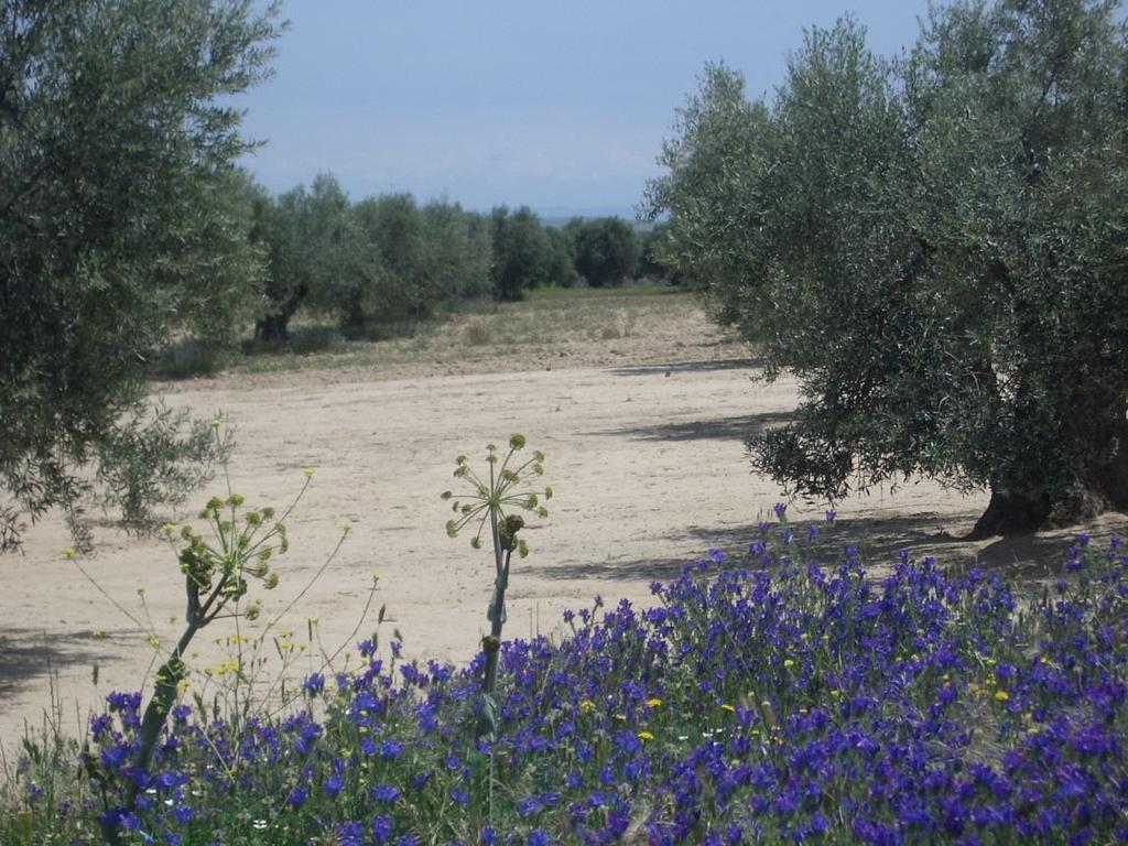
7 Study area: Camarena test site Traditional rainfed agricultural activities: Wheat/ Barley crops Vineyards Olive Groves Mediterranean climate: Avg. annual temp of 15.4 C Avg. annual precipitation of 357 mm Undulating topography, avg. ele.v. 625m a.s.l.


 Arcosic Sediment")
 associated with")
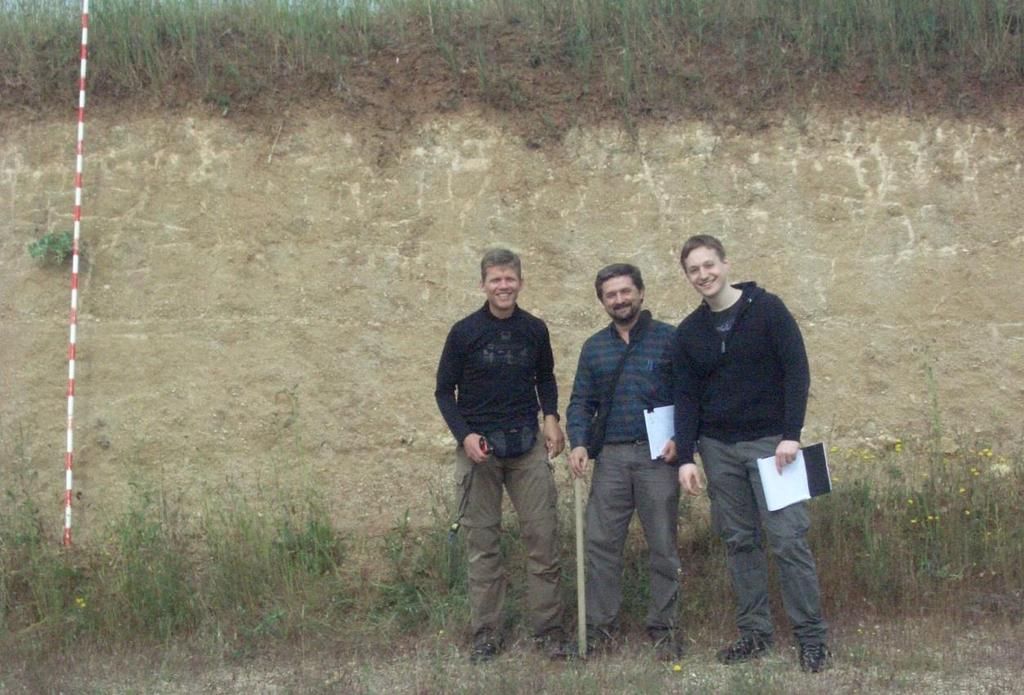
8 Study area: Soils Mostly evolved soils such as Calcic Haploxeralfs or Calcic Luvisols Typical soil profile (arcosic area) Arcosic Sediment Erosion features (water erosion) associated with contrasting soil horizons
9 Erosion model Soil profile modification by tillage along the slope (De Alba et al., 2004) 1- Soil truncation due to net soil loss 2- Substitution of surface horizons 3- Inversion of horizons 4- Soil accumulation --- Tillage depth


 LA Eagle mosaic")
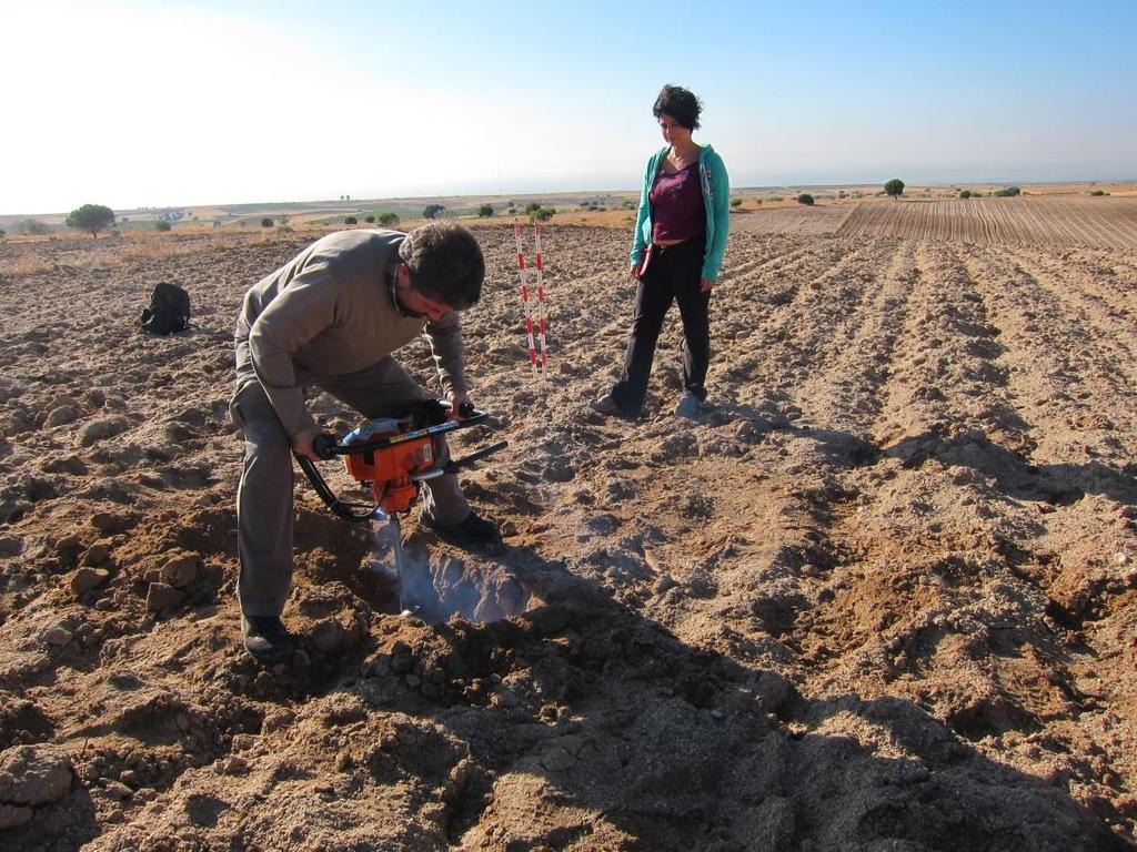
10 Data Field and laboratory data Field and laboratory spectroscopic analyses at selected sites linked with geo- and bio-geochemical analyses (soil characterisation, LAI, crop production) Soil sampling (0-10, 20-30, cm) in the different erosional stages Soil characterisation: ph, EC, OM, CaCO 3, Fe oxides, coarse fragments, texture, color, description, soil mineralogy Spatial multiscale sampling protocol Airborne data NERC AISA Eagle and Hawk hyperspectral data ( nm) at different altitudes: 1.5 and 3 m Low Alt, 3 and 6 m High Alt LIDAR ALS50 (DEM <1m) LA Eagle mosaic (Aug.8/2011) HA Eagle mosaic (Aug.10/2011)

 exposed at top")

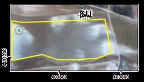
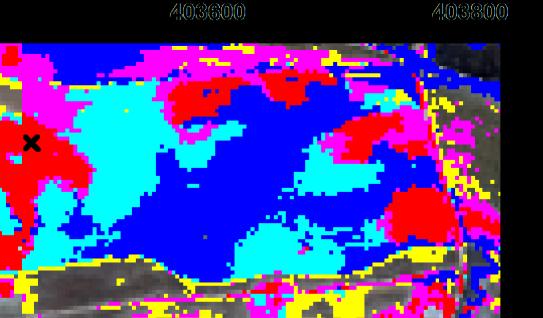
11 Analyses at selected sites NORTH E1/s2 location: Arcosic area SOUTH SU location: Carbonatic area E1P1 SU2 E2P2 SU1 ph~5.5, B-horizons (clay & ironrich) exposed at top slope, Sands in accumulation areas, locally carb precipitates ph~8 at SU2 point, carbonate horizons at top slope situation (Ck) due to net soil loss
 SU2 Same area identified by condition of wheat crop (chlorosis) SU test")
 Soil surface characteristics can be related with soil erosion states, land")
12 Multitemporal observations SU location: Carbonatic area (SU2) Subsurf soil horizon outcrop (Ck) SU2 Same area identified by condition of wheat crop (chlorosis) SU test site in fallow (08.Aug.11) and with wheat cultivation (23.Mar.12) Soil surface characteristics can be related with soil erosion states, land management and vegetation conditions


13 Mapping of soil properties based on AISA images s2 s2 s2 Camarena reflectance cube and predicted clay and iron spatial content
 (% w/w) (Holmgren, 1967) CLAYUSDA SILT % >2mmSAND CLAY SILT class SAND class S2P1_C 6,71 27 0,9 0,23 0,15 S2P2_C 6,69 43 1,0 0,30 0,27 S2P3_C 8,21 111 9,7 0,17 0,15 S2P4_C 6,92 59 1,1")
14 Definition of soil erosional stages classes SAMPLE ph EC CaCO3 organic matter Fe oxides Coarse TEXTURE fragments (% in <2mm TEXTURE fraction) (% in <2mm fraction) s2p1 s2p2 s2p4 s2p3 CRA (H2O 1:2,5) µs/cm (% w/w) (% w/w) (Holmgren, 1967) CLAYUSDA SILT % >2mmSAND CLAY SILT class SAND class S2P1_C 6, ,9 0,23 0,15 S2P2_C 6, ,0 0,30 0,27 S2P3_C 8, ,7 0,17 0,15 S2P4_C 6, ,1 0,61 0, sandy loam sandy clay sandy clay loam clay loam SU2_C 8, ,8 1,1 0, , sandy 24 clay loam 56 sandy clay loam High (Ck) Intermediate-high Intermediate Bt Internediate B Accumulation SU2 s2p3 s2p4 s2p2 s2p1 Image endmember reflectance spectra


15 Mapping of soil erosional stages s2 High Intermediate-high Intermediate Bt Internediate B Accumulation

16 Mapping of soil erosional stages (outlook)
17 Summary/Outlook Results Spatial distribution of combined variable occurrences in clay, carbonate, iron and sand content can be successfully detected at the field level and in most case at the remote sensing level Depending on lithological background, identification and mapping of different soil horizons could be tentatively linked to soil erosion states and accumulation areas Use of classification methods vs. quantification Next steps Prediction accuracy: Validation using representative number of locations More generic approaches (SVM) Upscale to higher spatial scale (3m 6m 30m) Transferability/ Application of the approach to other lithological and environmental background Link with hydrological and erosion modeling

18 Thank you for your attention!
Characterization of Soil Erosion Indicators Using Hyperspectral Data From a Mediterranean Rainfed Cultivated Region
 IEEE JOURNAL OF SELECTED TOPICS IN APPLIED EARTH OBSERVATIONS AND REMOTE SENSING, VOL. 9, NO. 2, FEBRUARY 2016 845 Characterization of Soil Erosion Indicators Using Hyperspectral Data From a Mediterranean
The role of soil spectral library for the food security issue
 The role of soil spectral library for the food security issue Eyal Ben-Dor Department of Geography Tel Aviv University The GEO-CRADLE project has received funding from the European Union s Horizon 2020
The HYperspectral SOil MApper (HYSOMA)
") EUFAR - EUropean Facility for Airborne Research The HYperspectral SOil MApper (HYSOMA Sabine Chabrillat, GFZ N4EWG12 - Hyperspectral Applications for Soil DePeMossi Workshop - August 29-31, 2011 GFZ Potsdam,
EUFAR - EUropean Facility for Airborne Research The HYperspectral SOil MApper (HYSOMA Sabine Chabrillat, GFZ N4EWG12 - Hyperspectral Applications for Soil DePeMossi Workshop - August 29-31, 2011 GFZ Potsdam,
Eyal Ben-Dor Department of Geography Tel Aviv University
 Spectral Imaging of Soils: past present and future Eyal Ben-Dor Department of Geography Tel Aviv University 2nd International Conference on Airborne Research for the Environment, DLR - the German Aerospace
Applications of Remote Sensing Systems. to MINERAL DEPOSIT DISCOVERY, DEVELOPMENT
 REMS 6022: Term Project Applications of Remote Sensing Systems to MINERAL DEPOSIT DISCOVERY, DEVELOPMENT and RECLAMATION Venessa Bennett OVERVIEW Remote Sensing data extensively used in all aspects of
Watershed Application of WEPP and Geospatial Interfaces. Dennis C. Flanagan
 Watershed Application of WEPP and Geospatial Interfaces Dennis C. Flanagan Research Agricultural Engineer USDA-Agricultural Research Service Adjunct Professor Purdue Univ., Dept. of Agric. & Biol. Eng.
Evaluating the information content of National ASTER Geoscience Maps in the Wagga Wagga and Cobar regions of New South Wales
 Evaluating the information content of National ASTER Geoscience Maps in the Wagga Wagga and Cobar regions of New South Wales The National ASTER Geoscience Maps, freely available from CSIRO/GA (https://data.csiro.au/dap/
From SARA (Germany)*) (= Satellitengestütztes Raummonitoring) to SASMO**) (=Satellite based spatial monitoring for Europe)
*) (= Satellitengestütztes Raummonitoring) to SASMO**) (=Satellite based spatial monitoring for Europe)") From SARA (Germany)*) (= Satellitengestütztes Raummonitoring) to SASMO**) (=Satellite based spatial monitoring for Europe) *) This cooperative project, funded by the Brandenburg Ministry for Economic Affairswas
From SARA (Germany)*) (= Satellitengestütztes Raummonitoring) to SASMO**) (=Satellite based spatial monitoring for Europe) *) This cooperative project, funded by the Brandenburg Ministry for Economic Affairswas
identify tile lines. The imagery used in tile lines identification should be processed in digital format.
 Question and Answers: Automated identification of tile drainage from remotely sensed data Bibi Naz, Srinivasulu Ale, Laura Bowling and Chris Johannsen Introduction: Subsurface drainage (popularly known
Daniel Spengler 1, 2, Sabine Chabrillat 1, Paula Escribano 3, Martin Bachmann 4 and Hermann Kaufmann 1
 Proceedings 5 th EARSeL Workshop on Imaging Spectroscopy. Bruges, Belgium, April 23-25 2007 1 DEVELOPMENT OF AN AUTOMATIC CLASSIFICATION ALGORITHM FOR DIFFERENTIATION OF VEGETATION STATUS IN SEMI-ARID
Using object oriented technique to extract jujube based on landsat8 OLI image in Jialuhe Basin
 Journal of Image Processing Theory and Applications (2016) 1: 16-20 Clausius Scientific Press, Canada Using object oriented technique to extract jujube based on landsat8 OLI image in Jialuhe Basin Guotao
MSCL-S: MULTI-SENSOR CORE LOGGER NON-DESTRUCTIVE CONTINUOUS CORE SCANNING FOR INDUSTRY & RESEARCH
 MSCL-S: MULTI-SENSOR CORE LOGGER NON-DESTRUCTIVE CONTINUOUS CORE SCANNING FOR INDUSTRY & RESEARCH IF CORE S WORTH TAKING, IT S WORTH LOGGING AUTOMATED & FLEXIBLE CORE LOGGING & SCANNING The Geotek Standard
The physical breakdown and chemical alteration of rocks and minerals at or near Earth s surface.
 The physical breakdown and chemical alteration of rocks and minerals at or near Earth s surface. The material that is chemically and mechanically weathered to yield sediment and soil. Regolith consisting
VENETO REGION PILOT AREA
 VENETO REGION PILOT AREA The pilot area is located in the north-east of Veneto region, located itself in the north-east of Italy. The area borders with Austria are in the northern part and run along high
Seek of Specific Soils in Puerto Rico using IKONOS
 Geological Aplication of Remote Sensing Copyright 2004 Department of Geology University of Puerto Rico, Mayagüez Seek of Specific Soils in Puerto Rico using IKONOS D. HERNÁNDEZ University of Puerto Rico
Soil Development. Soils Sustain Life
 Soil Development Soils Sustain Life Right off the Bat!! A soil is not a geologic deposit, it is a product of in situ weathering. Engineers, archaeologists, and others have learned that anything that is
Weathering, Soil, and Mass Movements
 Tarbuck Lutgens Weathering, Soil, and Mass Movements 5.1 Weathering Mechanical Weathering Mechanical weathering occurs when physical forces break rock into smaller and smaller pieces without changing the
DAMAGE DETECTION OF THE 2008 SICHUAN, CHINA EARTHQUAKE FROM ALOS OPTICAL IMAGES
 DAMAGE DETECTION OF THE 2008 SICHUAN, CHINA EARTHQUAKE FROM ALOS OPTICAL IMAGES Wen Liu, Fumio Yamazaki Department of Urban Environment Systems, Graduate School of Engineering, Chiba University, 1-33,
Application of SWAT Model to Estimate the Runoff and Sediment Load from the Right Bank Valleys of Mosul Dam Reservoir
 Application of SWAT Model to Estimate the Runoff and Sediment Load from the Right Bank Valleys of Mosul Dam Reservoir Dr Mohammad Ezeel Deen Prof. Nadhir Al-Ansari Prof Sven Knutsson Figure 1.Map of Iraq
Sparse Representation-based Analysis of Hyperspectral Remote Sensing Data
 Sparse Representation-based Analysis of Hyperspectral Remote Sensing Data Ribana Roscher Institute of Geodesy and Geoinformation Remote Sensing Group, University of Bonn 1 Remote Sensing Image Data Remote
THE UTILITY OF HYPERSPECTRAL DATA ON EXPLORATION OF SANDSTONE-HOSTED URANIUM DEPOSITS *
 THE UTILITY OF HYPERSPECTRAL DATA ON EXPLORATION OF SANDSTONE-HOSTED URANIUM DEPOSITS * Jie-lin Zhang Beijing Research Institute of Uranium Geology Key Laboratory of Remote Sensing Beijing 100029, China,
Surface soil moisture quantification and validation based on hyperspectral data and field measurements
 Journal of Applied Remote Sensing, Vol. 2, 023552 (31 December 2008) Surface soil moisture quantification and validation based on hyperspectral data and field measurements Sören-Nils Haubrock a, Sabine
Soil Erosion Calculation using Remote Sensing and GIS in Río Grande de Arecibo Watershed, Puerto Rico
 Soil Erosion Calculation using Remote Sensing and GIS in Río Grande de Arecibo Watershed, Puerto Rico Alejandra M. Rojas González Department of Civil Engineering University of Puerto Rico at Mayaguez.
Hyperspectral Data as a Tool for Mineral Exploration
 1 Hyperspectral Data as a Tool for Mineral Exploration Nahid Kavoosi, PhD candidate of remote sensing kavoosyn@yahoo.com Nahid Kavoosi Abstract In Geology a lot of minerals and rocks have characteristic
Biosphere. All living things, plants, animals, (even you!) are part of the zone of the earth called the biosphere.
 are part of the zone of the earth called the biosphere.") Unit 1 Study Guide Earth s Spheres Biosphere All living things, plants, animals, (even you!) are part of the zone of the earth called the biosphere. Hydrosphere Water covers ¾ of the earth, made up mostly
Unit 1 Study Guide Earth s Spheres Biosphere All living things, plants, animals, (even you!) are part of the zone of the earth called the biosphere. Hydrosphere Water covers ¾ of the earth, made up mostly
Using LST and SSE from Hyperspectral Thermal Infrared Airborne Data for Satellite Validation: Application to AisaOWL
 Using LST and SSE from Hyperspectral Thermal Infrared Airborne Data for Satellite Validation: Application to AisaOWL Mary Langsdale, Martin Wooster, Bruce Main, Daniel Fisher, Weidong Xu and Maniseng Sarrazy-Weston
Spanish national plan for land observation: new collaborative production system in Europe
 ADVANCE UNEDITED VERSION UNITED NATIONS E/CONF.103/5/Add.1 Economic and Social Affairs 9 July 2013 Tenth United Nations Regional Cartographic Conference for the Americas New York, 19-23, August 2013 Item
EMPIRICAL ESTIMATION OF VEGETATION PARAMETERS USING MULTISENSOR DATA FUSION
 EMPIRICAL ESTIMATION OF VEGETATION PARAMETERS USING MULTISENSOR DATA FUSION Franz KURZ and Olaf HELLWICH Chair for Photogrammetry and Remote Sensing Technische Universität München, D-80290 Munich, Germany
Satellite ASTER Global Geoscience Maps
 Satellite ASTER Global Geoscience Maps Michael Abrams Jet Propulsion Laboratory, California Institute of Technology, Pasadena USA (c) 2017 California Institute of Technology. Government sponsorship acknowledged.
CHAPTER-7 INTERFEROMETRIC ANALYSIS OF SPACEBORNE ENVISAT-ASAR DATA FOR VEGETATION CLASSIFICATION
 147 CHAPTER-7 INTERFEROMETRIC ANALYSIS OF SPACEBORNE ENVISAT-ASAR DATA FOR VEGETATION CLASSIFICATION 7.1 INTRODUCTION: Interferometric synthetic aperture radar (InSAR) is a rapidly evolving SAR remote
4. Soils and soil conditions
 4. Soils and soil conditions 4.1 General characteristics 4.1.1 Soil-forming processes Most soils of the Bardenas area show no distinct characteristics of soil development. Except in the ancient alluvium
Supplementary Material: Crop & Pasture Science, 2013, 64(12),
,") 10.1071/CP13168_AC CSIRO 2013 Supplementary Material: Crop & Pasture Science, 2013, 64(12), 1182 1194. Hydrological and water-use efficiency implications of geomorphological stratification in palæochannels
10.1071/CP13168_AC CSIRO 2013 Supplementary Material: Crop & Pasture Science, 2013, 64(12), 1182 1194. Hydrological and water-use efficiency implications of geomorphological stratification in palæochannels
Spectroscopy-supported digital soil mapping
 Spectroscopy-supported digital soil mapping Outline Introduction Project and theoretical background Field sampling Estimating and mapping soil mineralogy Conclusion & outlook The nation that destroys its
RADAR Remote Sensing Application Examples
 RADAR Remote Sensing Application Examples! All-weather capability: Microwave penetrates clouds! Construction of short-interval time series through cloud cover - crop-growth cycle! Roughness - Land cover,
SEMIARID regions are especially vulnerable to climate
 IEEE JOURNAL OF SELECTED TOPICS IN APPLIED EARTH OBSERVATIONS AND REMOTE SENSING, VOL. 9, NO. 9, SEPTEMBER 2016 3997 Combining Field and Imaging Spectroscopy to Map Soil Organic Carbon in a Semiarid Environment
Introduction to Soil Science and Wetlands Kids at Wilderness Camp
 Introduction to Soil Science and Wetlands Kids at Wilderness Camp Presented by: Mr. Brian Oram, PG, PASEO B.F. Environmental Consultants http://www.bfenvironmental.com and Keystone Clean Water Team http://www.pacleanwater.org
Gully erosion in winter crops: a case study from Bragança area, NE Portugal
 Gully erosion in winter crops: a case study from Bragança area, NE Portugal T. de Figueiredo Instituto Politécnico de Bragança (IPB/ESAB), CIMO Mountain Research Centre, Bragança, Portugal Foreword This
Assessing Drought in Agricultural Area of central U.S. with the MODIS sensor
 Assessing Drought in Agricultural Area of central U.S. with the MODIS sensor Di Wu George Mason University Oct 17 th, 2012 Introduction: Drought is one of the major natural hazards which has devastating
Multi-scale Soil Moisture Model Calibration and Validation: Evan Coopersmith & Michael Cosh, USDA-ARS, Dept. of Hydrology and Remote Sensing
 Multi-scale Soil Moisture Model Calibration and Validation: Evan Coopersmith & Michael Cosh, USDA-ARS, Dept. of Hydrology and Remote Sensing An Ideal Location: Three Types of Similarity Hydro-climatic
Fundamentals of Remote Sensing
 Division of Spatial Information Science Graduate School Life and Environment Sciences University of Tsukuba Fundamentals of Remote Sensing Prof. Dr. Yuji Murayama Surantha Dassanayake 10/6/2010 1 Fundamentals
Evaluation of the SWAT Model Setup Process Through A Case Study in Roxo Catchment, Portugal
 Evaluation of the SWAT Model Setup Process Through A Case Study in Roxo Catchment, Portugal Mustafa Gökmen Master Degree in on Geo-information and Earth Observation for Integrated Catchment and Water Resources
Landcover Dynamics in the Niger Inland Delta (Mali)
") Fakultät Forst-, Geo- Hydrowissenschaften Institut f. Photogrammetrie & Fernerkundung, Professur Fernerkundung Landcover Dynamics in the Niger Inland Delta (Mali) A Classification Approach for MERIS Data
Fakultät Forst-, Geo- Hydrowissenschaften Institut f. Photogrammetrie & Fernerkundung, Professur Fernerkundung Landcover Dynamics in the Niger Inland Delta (Mali) A Classification Approach for MERIS Data
Soil Morphology and Stratigraphy on an Erosional Footslope: Dickinson Experiment Station in Western North Dakota
 Soil Morphology and Stratigraphy on an Erosional Footslope: Dickinson Experiment Station in Western North Dakota By D. Claypool, D. G. Hopkins, and J. L. Richardson ABSTRACT A first order soil survey of
Weathering and Soil Formation. Chapter 10
 Weathering and Soil Formation Chapter 10 Old and New Mountains The Appalachian Mountains appear very different from the Sierra Mountains. The Appalachians are smaller, rounded, gently sloping, and covered
Earth Science, 10e. Edward J. Tarbuck & Frederick K. Lutgens
 Earth Science, 10e Edward J. Tarbuck & Frederick K. Lutgens Weathering, Soil, and Mass Wasting Chapter 3 Earth Science, 10e Stan Hatfield and Ken Pinzke Southwestern Illinois College Earth's external processes
Coupling a basin erosion and river sediment transport model into a large scale hydrological model
 Hydrology and Geodynamics of the basins of South America 4 th scientific meeting of ORE HYBAM www.ore-hybam.org Lima, 6-9 September 2011 Coupling a basin erosion and river sediment transport model into
Delineation of Groundwater Potential Zone on Brantas Groundwater Basin
 Delineation of Groundwater Potential Zone on Brantas Groundwater Basin Andi Rachman Putra 1, Ali Masduqi 2 1,2 Departement of Environmental Engineering, Sepuluh Nopember Institute of Technology, Indonesia
Assessment of solid load and siltation potential of dams reservoirs in the High Atlas of Marrakech (Moorcco) using SWAT Model
 using SWAT Model") Assessment of solid load and siltation potential of dams reservoirs in the High Atlas of Marrakech (Moorcco) using SWAT Model Amal Markhi: Phd Student Supervisor: Pr :N.Laftrouhi Contextualization Facing
Assessment of solid load and siltation potential of dams reservoirs in the High Atlas of Marrakech (Moorcco) using SWAT Model Amal Markhi: Phd Student Supervisor: Pr :N.Laftrouhi Contextualization Facing
Mechanical Weathering
 Weathering is the disintegration and decomposition of material at or near the surface. Erosion is the incorporation and transportation of material by a mobile agent, usually water, wind, or ice. Geologists
The effect of soil physical parameters on soil erosion. Introduction. The K-factor
 Geographical Bulletin 2004. Tom. LIII. No. 1 2. pp.77 84. The effect of soil physical parameters on soil erosion ÁDÁM KERTÉSZ TAMÁS HUSZÁR GERGELY JAKAB 1 Introduction The factor K of the Universal Soil
USING HYPERSPECTRAL IMAGERY
 USING HYPERSPECTRAL IMAGERY AND LIDAR DATA TO DETECT PLANT INVASIONS 2016 ESRI CANADA SCHOLARSHIP APPLICATION CURTIS CHANCE M.SC. CANDIDATE FACULTY OF FORESTRY UNIVERSITY OF BRITISH COLUMBIA CURTIS.CHANCE@ALUMNI.UBC.CA
Monday, October 15 th Grab a textbook! Objective: We will explain the formation of different soils and classify soils according to particle size.
 Soil Mr. Gilmore Monday, October 15 th Grab a textbook! Objective: We will explain the formation of different soils and classify soils according to particle size. Review: 1. The four limestone samples
Civil Engineering Journal
 Available online at www.civilejournal.org Civil Engineering Journal Vol. 1, No. 2, December, 2015 Comparative Study of Landsat and Aster Data by Morphometric Analysis Sujit Kumar a*, Tapasi Bhandary b
ESM 186 Environmental Remote Sensing and ESM 186 Lab Syllabus Winter 2012
 ESM 186 Environmental Remote Sensing and ESM 186 Lab Syllabus Winter 2012 Instructor: Susan Ustin (slustin@ucdavis.edu) Phone: 752-0621 Office: 233 Veihmeyer Hall and 115A, the Barn Office Hours: Tuesday
Agricultural land-use from space. David Pairman and Heather North
 Agricultural land-use from space David Pairman and Heather North Talk Outline Motivation Challenges Different approach Paddock boundaries Classifications Examples Accuracy Issues Data sources Future possibilities
The Soils and Land Capability for Agriculture. Land North of Aberdeen, Aberdeenshire
 The Soils and Land Capability for Agriculture Of Land North of Aberdeen, Aberdeenshire Report prepared for Peter Radmall Associates May 2012 Reading Agricultural Consultants Ltd Beechwood Court, Long Toll,
Geometric and Landcover Signatures of Local Authorities in Peloponnesus
 Geometric and Landcover Signatures of Local Authorities in Peloponnesus GEORGE CH. MILIARESIS Department of Geology University of Patras Geology Department, University of Patras, Rion 265-04 GREECE gmiliar@upatras.gr
MULTICHANNEL NADIR SPECTROMETER FOR THEMATICALLY ORIENTED REMOTE SENSING INVESTIGATIONS
 S E S 2 5 Scientific Conference SPACE, ECOLOGY, SAFETY with International Participation 1 13 June 25, Varna, Bulgaria MULTICHANNEL NADIR SPECTROMETER FOR THEMATICALLY ORIENTED REMOTE SENSING INVESTIGATIONS
Mapping Soils, Crops, and Rangelands by Machine Analysis of Multi-Temporal ERTS-1 Data
 Purdue University Purdue e-pubs LARS Technical Reports Laboratory for Applications of Remote Sensing 1-1-1973 Mapping Soils, Crops, and Rangelands by Machine Analysis of Multi-Temporal ERTS-1 Data M. F.
GIS Techniques for Floodplain Delineation. Dean Djokic
 GIS Techniques for Floodplain Delineation Dean Djokic (ddjokic@esri.com) Content What is a floodplain? How to get a floodplain? What can GIS do for floodplain modeling? Simple GIS techniques for floodplain
14. Weathering and Regolith
 The Australian Continent: A Geophysical Synthesis Weathering and Regolith 123 14. Weathering and Regolith The regolith consists of the zone at the Earth's surface between fresh rock and the interface with
EXPLORING THE DEMANDS ON HYPERSPECTRAL DATA PRODUCTS FOR URBAN PLANNING: A CASE STUDY IN THE MUNICH REGION
 EXPLORING THE DEMANDS ON HYPERSPECTRAL DATA PRODUCTS FOR URBAN PLANNING: A CASE STUDY IN THE MUNICH REGION W.Heldens 1, T. Esch 2, U. Heiden 2, A. Müller 2 and S. Dech 1,2 1 Department of Remote Sensing,
HYPERSPECTRAL IMAGING
 1 HYPERSPECTRAL IMAGING Lecture 9 Multispectral Vs. Hyperspectral 2 The term hyperspectral usually refers to an instrument whose spectral bands are constrained to the region of solar illumination, i.e.,
Regionalization Methods for Watershed Management - Hydrology and Soil Erosion from Point to Regional Scales
 This paper was peer-reviewed for scientific content. Pages 1062-1067. In: D.E. Stott, R.H. Mohtar and G.C. Steinhardt (eds). 2001. Sustaining the Global Farm. Selected papers from the 10th International
Conservation Planning evaluate land management alternatives to reduce soil erosion to acceptable levels. Resource Inventories estimate current and
 Conservation Planning evaluate land management alternatives to reduce soil erosion to acceptable levels. Resource Inventories estimate current and projected erosion levels and their impact on natural resource
INTRODUCTION TO ARCGIS 10
 Department of Irrigation, Drainage and Landscape Engineering, Faculty of Civil Engineering, CTU Prague Institute of Hydraulics and Rural Water Management BOKU Vienna INTRODUCTION TO ARCGIS 10 MAIN WINDOW
Drought Estimation Maps by Means of Multidate Landsat Fused Images
 Remote Sensing for Science, Education, Rainer Reuter (Editor) and Natural and Cultural Heritage EARSeL, 2010 Drought Estimation Maps by Means of Multidate Landsat Fused Images Diego RENZA, Estíbaliz MARTINEZ,
Dynamic Land Cover Dataset Product Description
 Dynamic Land Cover Dataset Product Description V1.0 27 May 2014 D2014-40362 Unclassified Table of Contents Document History... 3 A Summary Description... 4 Sheet A.1 Definition and Usage... 4 Sheet A.2
Maggie Payne Jim Turenne
 Maggie Payne Jim Turenne USDA-NRCS 60 Quaker Lane, Suite 46 Warwick, RI. 02886 401-822-8832 maggie.payne@ri.usda.gov U.S. Department of Agriculture 1935: Soil Conservation Service (SCS) Natural Resources
Integrating Remote Sensing and Observations into Decision Support Systems for Invasive Weeds
 Integrating Remote Sensing and Observations into Decision Support Systems for Invasive Weeds E. Raymond Hunt, Jr. USDA-ARS Hydrology and Remote Sensing Laboratory Beltsville, Maryland, USA Objectives Predict
Preliminary analysis of distributed in situ soil moisture measurements
 Advances in Geosciences, 2, 81 86, 2005 SRef-ID: 1680-7359/adgeo/2005-2-81 European Geosciences Union 2005 Author(s). This work is licensed under a Creative Commons License. Advances in Geosciences Preliminary
Scientific registration n : 2180 Symposium n : 35 Presentation : poster MULDERS M.A.
 Scientific registration n : 2180 Symposium n : 35 Presentation : poster GIS and Remote sensing as tools to map soils in Zoundwéogo (Burkina Faso) SIG et télédétection, aides à la cartographie des sols
Analyzing spatial and temporal variation of water balance components in La Vi catchment, Binh Dinh province, Vietnam
 Analyzing spatial and temporal variation of water balance components in La Vi catchment, Binh Dinh province, Vietnam Nguyen Duy Liem, Vo Ngoc Quynh Tram, Nguyen Le Tan Dat, Nguyen Kim Loi Nong Lam University-
Monday, Oct Field trip A1 & A2 signups: make sure you are where you think you should be
 Monday, Oct. 4 1. Field trip A1 & A2 signups: make sure you are where you think you should be 2. 5 credit people, field trip introduction in lab today 1. If you are unable to attend THIS SATURDAY, let
Laboratory, field and airborne spectroscopy for monitoring organic carbon content in agricultural soils
 Laboratory, field and airborne spectroscopy for monitoring organic carbon content in agricultural soils A. Stevens, B. van Wesemael, B. Tychon, D. Rosillon, H. Bartholomeus, E. Ben Dor Département de géographie
Earth systems the big idea guiding questions Chapter 1 & 2 Earth and Earth Systems review notes are in purple
 Earth systems the big idea guiding questions Chapter 1 & 2 Earth and Earth Systems review notes are in purple How can you describe Earth? What are the composition and the structure of the atmosphere? How
ESRI GIS For Mining Seminar, 10 th August, 2016, Nairobi, Kenya. Spatial DATA Solutions for Mining
 ESRI GIS For Mining Seminar, 10 th August, 2016, Nairobi, Kenya Spatial DATA Solutions for Mining Spatial Data Solutions for Mining Spatial - Data that identifies the geographic location of features &
Mapping Epithermal Alteration Mineralogy with High Spatial Resolution Hyperspectral Imaging of Rock Samples
 Mapping Epithermal Alteration Mineralogy with High Spatial Resolution Hyperspectral Imaging of Rock Samples Cecilia Contreras Co-authors: Dr. Chris Hecker Dr. Freek van der Meer GRSG 28 th International
Regionalization in Hydrology (Proceedings of a conference held at Braunschweig, March 1997). IAHS Publ. no. 254,
. IAHS Publ. no. 254,") Regionalization in Hydrology (Proceedings of a conference held at Braunschweig, March 1997). IAHS Publ. no. 254, 1999. 131 Regionalization of évapotranspiration modelling using multitemporal spectral unmixing
Regionalization in Hydrology (Proceedings of a conference held at Braunschweig, March 1997). IAHS Publ. no. 254, 1999. 131 Regionalization of évapotranspiration modelling using multitemporal spectral unmixing
Hyper-Spectral and Copernicus Evolution
 Hyper-Spectral and Copernicus Evolution Antonio Ciccolella - ESA Roma, 1 March 2017 Issue/Revision: 0.0 Reference: ESA UNCLASSIFIED Status: - For Official Use ESA UNCLASSIFIED - For Official Use Hyperspectral
Monument Valley, Utah. What weathering processes contributed to the development of these remarkable rock formations? Weathering Mechanisms
 Monument Valley, Utah. What weathering processes contributed to the development of these remarkable rock formations? Weathering Includes Physical, Chemical, Biological processes WEATHERING CHAPTER 7 Weathering
EU-level landslide susceptibility assessment
 in the context t of the Soil Thematic Strategy t Andreas Günther 1, Miet Van Den Eeckhaut 2, Paola Reichenbach h 3, Javier Hervás 2 & Jean-Philippe Malet 4 1 Federal Institute for Geosciences and Natural
Lecture 6: Soil Profiles: Diagnostic Horizons
 Lecture 6: Soil Profiles: Diagnostic Horizons Complexity in Soil Profiles Soil Horizons Soils display distinct layering O Horizon: Partially decomposed organic matter (OM) A Horizon: Near surface, mineral
Italian experience with the interpretation of FOCUS surface water scenarios from a regulatory point of view
 Italian experience with the interpretation of FOCUS surface water scenarios from a regulatory point of view G. Azimonti, G. Triacchini, D. Auteri, E. Redolfi, International Centre for Pesticides and Health
PREDICTION OF SOIL ORGANIC CARBON CONTENT BY SPECTROSCOPY AT EUROPEAN SCALE USING A LOCAL PARTIAL LEAST SQUARE REGRESSION APPROACH
 Proceedings of the 13 th International Conference on Environmental Science and Technology Athens, Greece, 5-7 September 2013 PREDICTION OF SOIL ORGANIC CARBON CONTENT BY SPECTROSCOPY AT EUROPEAN SCALE
INTRODUCTION Landslides are bad but good
 Mapping Current and Future Landslide Susceptibility with GIS for the Tualatin Mountains, Oregon, USA Ian Cogar Jesse Roper INTRODUCTION Landslides are bad but good Avg. Annual Cost $2 billion and 20 50
Engineering Geology ECIV 3302
 Engineering Geology ECIV 3302 Instructor : Dr. Jehad Hamad 2019-2018 Chapter (5) Weathering & Soil Chapter 5: Weathering, Soil, and Mass Wasting External processes include : (1) Weathering (2) Mass wasting
NERC Geophysical Equipment Facility - View more reports on our website at
 NERC GEOPHYSICAL EQUIPMENT FACILITY LOAN 877 SCIENTIFIC REPORT Modelling gap microclimates in broadleaved deciduous forests using remotely sensed data: the contribution of GPS to geometric correction and
Ramani Geosystems. Putting Africa On The Map. Authorized Resellers
 Ramani Geosystems Putting Africa On The Map Authorized Resellers Ramani Profile Started in 1999 Aerial, Land Surveying & Mapping Solutions + 10 Countries in the region + 80 Staff working in projects Asset
Rating of soil heterogeneity using by satellite images
 Rating of soil heterogeneity using by satellite images JAROSLAV NOVAK, VOJTECH LUKAS, JAN KREN Department of Agrosystems and Bioclimatology Mendel University in Brno Zemedelska 1, 613 00 Brno CZECH REPUBLIC
Soil Formation. Parent Material. Time. Climate
 Soil Formation Parent Material Time Climate Topography Biota Main Objectives 1. Gain a general understanding of soil formation processes 2. Understand the importance of mineral weathering in soil formation
HEAVY MINERALS INVESTIGATION USING GEOSPATIAL TECHNOLOGY
 HEAVY MINERALS INVESTIGATION USING GEOSPATIAL TECHNOLOGY *Muthiah.M.S, **Colins Johnny.J, *PG student: Department of Civil Engineering, Anna University Regional Campus Tirunelveli, India **Assistant Professor:
Aldo Ferrero, Francesco Vidotto, Fernando De Palo. RUNOFF team
 TOPPS ACADEMY 15-1818 th June 2015 Grugliasco (TO) Aldo Ferrero, Francesco Vidotto, Fernando De Palo RUNOFF team DIAGNOSIS what data do we need? collection of territorial data (soils, elevation, slope,
Weathering is the process that breaks down rock and other substances at Earth s surface
 Chapter 8 Notes Weathering is the process that breaks down rock and other substances at Earth s surface Factors that contribute to weathering Heat Cold Water Ice O 2 & CO 2 in the atmosphere Examples of
Assembling information to develop ecological site and state and transition concepts. Brandon Bestelmeyer, Jornada Experimental Range, Las Cruces, NM
 Assembling information to develop ecological site and state and transition concepts Brandon Bestelmeyer, Jornada Experimental Range, Las Cruces, NM Concepts: Ecological site: division of the landscape
Object Based Imagery Exploration with. Outline
 Object Based Imagery Exploration with Dan Craver Portland State University June 11, 2007 Outline Overview Getting Started Processing and Derivatives Object-oriented classification Literature review Demo
QUANTITATIVE RETRIEVAL OF SOIL ORGANIC CARBON USING LABORATORY SPECTROSCOPY AND SPECTRAL INDICES
 QUANTITATIVE RETRIEVAL OF SOIL ORGANIC CARBON USING LABORATORY SPECTROSCOPY AND SPECTRAL INDICES Harm Bartholomeus a,*, Michael Schaepman a, Lammert Kooistra a, Antoine Stevens b, Willem Hoogmoed c, Otto
Application of a Land Surface Temperature Validation Protocol to AATSR data. Dar ren Ghent1, Fr ank Göttsche2, Folke Olesen2 & John Remedios1
 Application of a Land Surface Temperature Validation Protocol to AATSR data Dar ren Ghent1, Fr ank Göttsche, Folke Olesen & John Remedios1 1 E a r t h O b s e r v a t i o n S c i e n c e, D e p a r t m
Measuring & monitoring soil carbon. Ermias Aynekulu Betemariam, Keith Shepherd, Richard Coe, Markus Walsh, Tor-G Vagen & Leigh Winowiecki
 Measuring & monitoring soil carbon Ermias Aynekulu Betemariam, Keith Shepherd, Richard Coe, Markus Walsh, Tor-G Vagen & Leigh Winowiecki September 13 2012 Issues There is a lack of coherent and rigorous
Anjana Dewanji, Anindita Chatterjee & Achyut Kumar Banerjee. Agricultural & Ecological Research Unit Indian Statistical Institute Kolkata, India
 Anjana Dewanji, Anindita Chatterjee & Achyut Kumar Banerjee Agricultural & Ecological Research Unit Indian Statistical Institute Kolkata, India World wide distribution Distribution in India Present scenario