QuantumWeather. A weather based decision support system for the utility industry. Bob Pasken and Bill Dannevik Saint Louis University
|
|
|
- Jean Morrison
- 5 years ago
- Views:
Transcription
1 A weather based decision support system for the utility industry Bob Pasken and Bill Dannevik Saint Louis University
2 Before we start I would like to say thank you to Dave Wakeman Kevin Anders Steve Brophy John Simmins
3 Begin with a short history of how AmerenMissouri and Saint Louis University became partners. Describe of what QuantumWeather is and how it works. Describe work in progress. Leave time for questions
4 The project had its origins as a tool to forecast pollen concentration for Asthma sufferers. The tool produced very accurate pollen concentration forecasts. The success of the pollen forecasts led to the question, can this level of accuracy be maintained on a daily basis or were we just lucky? A graduate student began running the tool 4 times a day every day to determine the long term accuracy of the tool.
5 On July 19 th, 2006 the early morning forecast runs indicated that St. Louis would experience severe weather The late morning forecast indicated the kind of severe weather. Unfortunately St. Louis University does not have the authority to issue severe weather warnings.
6
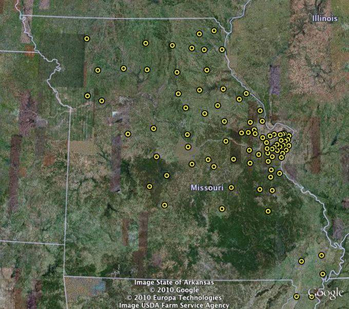
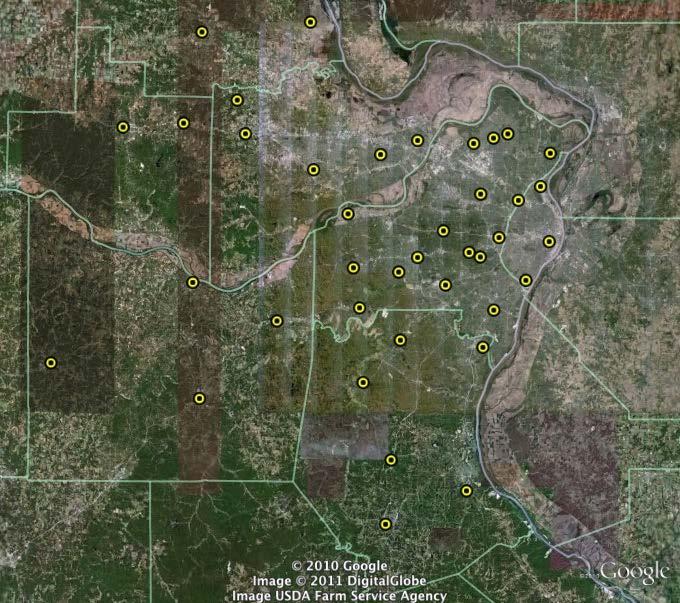
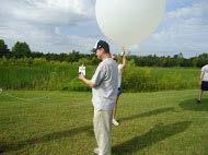
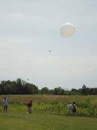
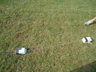
7
8
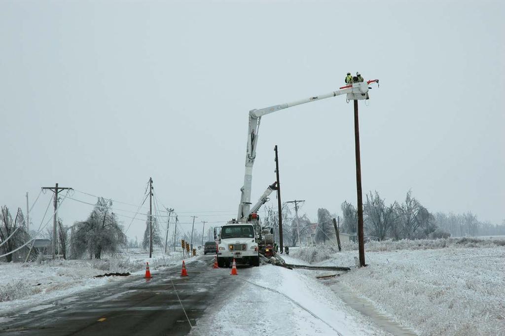
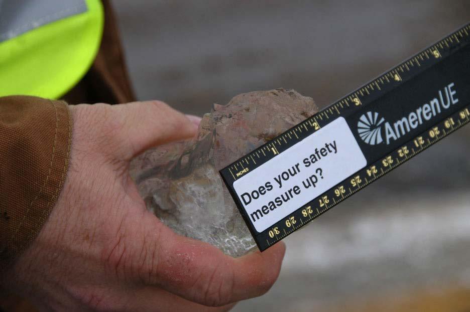
9 AmerenMissouri had 500,000 customers without power in 100 heat. Then starting on November 30 th 2006 an ice storm across southern Missouri resulted in another 500,000 Ameren customers without power in below freezing temperatures.
10 In January 2007 an editorial in the Saint Louis Post-Dispatch chastised AmerenMissouri for not responding in a more timely fashion. Bill Dannevik and I approached AmerenMissouri with a plan to help them respond more quickly. The joint AmerenMissouri/Saint Louis University project is called QuantumWeather.
11 QuantumWeather is a weather-based decision support system. QuantumWeather combines high spatial and temporal resolution meteorological forecasts with information on the power grid configuration, local ground and tree cover information, and historical power outage information to pinpoint areas at highest risk of power interruption.
12 Provides AmerenMissouri the ability to prioritize efforts to restore service by focusing efforts in those areas most severely affected by the event. Direct crews to those areas known to be affected rather than searching for damage post event. Aid in positioning crews in areas that make them as effective as possible.
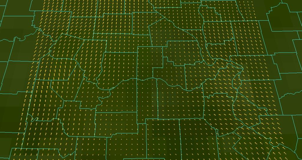
13 How does QuantumWeather make these forecasts? What makes us better than NWS? TWC? AccuWeather? Combination of high quality data and a cutting edge numerical forecast model We start higher resolution data

14 We have a network of 100 surface observations spread through out eastern Missouri.
15
16
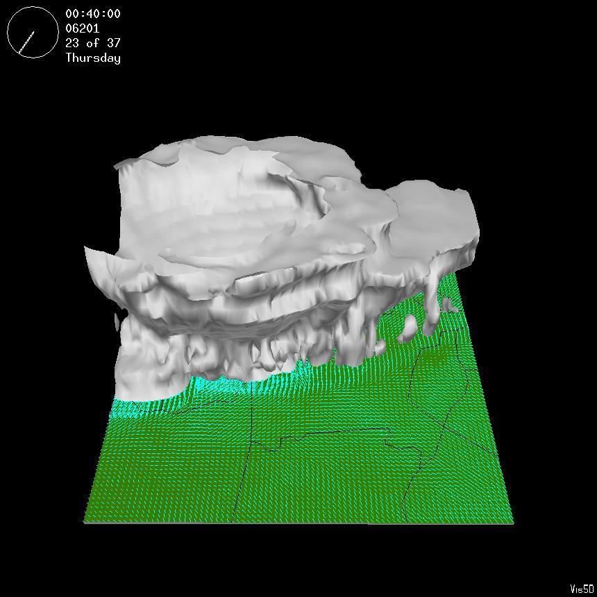
17 We have two radiosondes to probe the vertical structure of the atmosphere.

18
19 How does QuantumWeather make these forecasts? We get surface observations once a minute Surface data at each site is transmitted to AmerenMissouri and then to SLU. Upper air data by AmerenMissouri and Saint Louis University
20 How does QuantumWeather make these forecasts? Data is quality controlled every 5 minutes and quality assurance tests 10 minutes Maintenance and calibration on all sensors done once a year or when a failure occurs
21 QuantumWeather feeds this higher spatial and temporal resolution data into a numerical weather prediction model that has been tuned for our customers needs Ameren needs wind and sleet/freezing rain forecasts The threat posed is seasonally dependent and adjusted seasonally.
22 How much improvement in forecast quality does the addition of the mesonet data provide? Subject of on going research Rigorously comparing twice daily model forecasts with and without mesonet data against observations over an entire year Rigorously comparing selected day Days with significant weather Days without significant weather
23
24 How does QuantumWeather make these forecasts? Data ingest, QC and QA is automated and part of the QuantumWeather patent suite An automated process that is part of the patent suite prepares all of this data for model input and for analysis before, during and after events Analysis plots give the forecaster a better picture of the event as it unfolds
25 You might be saying to yourself at this point: Ok, I get that Saint Louis University s meteorologists and their models are good. What good does that do me as a utility operator?
26 The answer to this question is that we combine other kinds of data with the meteorology to create an integrated view. By combining the analysis from the model, the mesonet data, the location and health of vegetation, and the location of AmerenMissouri s above ground assets present a picture of how, when and where a particular weather event will impact AmerenMissouri.
27 Further AmerenMissouri has a much better picture of what assets were affected by the weather event. Knowing that the highest wind speed or greatest accumulations of ice occurred at precise locations makes the job of determining the cause and location of the problem easier. Driving around at night in the rain looking for a downed power line is not high on my bucket list
28 Currently QuantumWeather does not overlay weather and vegetation data on top of the location of AmerenMissouri assets. Forecasts are available in several formats: GoogleEarth IDV Vegetation, land cover and land use data is available in several formats.
29 The location of AmerenMissouri assets has not been available until just recently. Integration of AmerenMissouri assets and other data has just begun. How the integration of the meteorology, land use and cover, and AmerenMissouri assets is done is still an open question Requires close cooperation with the team from AmerenMIssouri
30 As an example of how QuantumWeather works: In January 2009 QuantumWeather forecasters notified AmerenMissouri that a major ice storm would hit southern Missouri. QuantumWeather forecasters told AmerenMissouri that ice would accumulate at a rate of 0.15 an hour beginning in the late afternoon/early evening and end at Midnight. AmerenMissouri trusted QuantumWeather Forecasters.
31 AmerenMissouri committed nearly all of it s resources to southern Missouri before the storm began. AmerenMissouri had the right resources and crews on site as the ice began to accumulate. AmerenMissouri was able to restore power to it s customers before neighboring Utility companies were able to arrive on site.
32
33
34 The Forecasts from SLU and Quantum Weather have been extremely valuable. Not only can they tell us when something is going to happen they also help us understand when we are not at risk. This helps our Customer and our employees. We can respond faster, often in advance and let employees go home when the there is not a threat. This partnership provided huge benefits to all of our stakeholders during the 2009 Ice storm. We had people, equipment, and materials in place before any ice ever formed. This improved our response and also reduced needed travel during difficult driving conditions. They got it right so we got it right. We got our customer restored faster than thought possible, geographically correct and specific advanced warning is the key David N. Wakeman Vice President Energy Delivery AmerenMissouri
Table-Top Exercise for Emergency Preparedness Evaluation: Little Anse, Isle Madame
 Table-Top Exercise for Emergency Preparedness Evaluation: Little Anse, Isle Madame Alexander Chung, M.Sc. Candidate C-Change Student Research Associate May 2013 The Community of Little Anse Coastal community
Deep Thunder. Local Area Precision Forecasting for Weather-Sensitive Business Operations (e.g. Electric Utility)
") 1 Deep Thunder Local Area Precision Forecasting for Weather-Sensitive Business Operations (e.g. Electric Utility) Dipl. Ing. Helmut Ludwar Chief Technologist Wien, im Oktober 2010 Forecasts for Weather-Sensitive
1 Deep Thunder Local Area Precision Forecasting for Weather-Sensitive Business Operations (e.g. Electric Utility) Dipl. Ing. Helmut Ludwar Chief Technologist Wien, im Oktober 2010 Forecasts for Weather-Sensitive
Southern California Edison Wildfire Mitigation & Grid Resiliency
 Southern California Edison Wildfire Mitigation & Grid Resiliency California State Legislative Conference Committee on Wildfire Preparedness and Response August 7, 2018 CALIFORNIA S WILDFIRE RISK Year-Round
Risk Management of Storm Damage to Overhead Power Lines
 Risk Management of Storm Damage to Overhead Power Lines David Wanik, Jichao He, Brian Hartman, and Emmanouil Anagnostou Departments of Statistics, Mathematics, and Environmental and Civil Engineering University
Winter Ready DC District of Columbia Public Service Commission
 Winter Ready DC District of Columbia Public Service Commission Presented by: Michael Poncia, Vice President, Customer Operations, Pepco Holdings October 26, 2017 Preparing our System Improving our system
The Leader in Landscape Solutions
 The Leader in Landscape Solutions Emergency Action Plan Hurricane Preparedness Go To Mainscape.com For More Information! Purpose: To provide the Federation at Kings Point and their residents an informative
How Power is Restored After a Severe Storm. Presented by Stacy Shaw, Safety Director & Nolan Hartzler, GIS Mapping Technician
 How Power is Restored After a Severe Storm Presented by Stacy Shaw, Safety Director & Nolan Hartzler, GIS Mapping Technician Hurricanes, ice storms, tornadoes One inch of ice on a single span of electric
Creating Distribution Boundaries Using Computational Geometry & Meteorological Mesonet Better Predictions for Storm Damage
 Creating Distribution Boundaries Using Computational Geometry & Meteorological Mesonet Better Predictions for Storm Damage EPRI GIS Interest Group Webcast May 22, 2014 Legal Notices Please observe these
Operational MRCC Tools Useful and Usable by the National Weather Service
 Operational MRCC Tools Useful and Usable by the National Weather Service Vegetation Impact Program (VIP): Frost / Freeze Project Beth Hall Accumulated Winter Season Severity Index (AWSSI) Steve Hilberg
PUBLIC SAFETY POWER SHUTOFF POLICIES AND PROCEDURES
 PACIFIC GAS AND ELECTRIC COMPANY PUBLIC SAFETY POWER SHUTOFF POLICIES AND PROCEDURES SEPTEMBER 2018 1 PACIFIC GAS AND ELECTRIC COMPANY PUBLIC SAFETY POWER SHUTOFF POLICIES AND PROCEDURES SEPTEMBER 2018
New Forecast Section. connection. Volume 3 Issue 4 April 2012
 Volume 3 Issue 4 April 2012 connection www.mesonet.org New Forecast Section Spring has arrived, and so has storm season. For many, that means monitoring the weather and forecast more. To help users prepare
Director, Operations Services, Met-Ed
 Director, Operations Services, Met-Ed Pennsylvania House Republican Policy Committee Hearing on Storm Response Tobyhanna Township Municipal Building Pocono Pines, Pa. August 9, 2018 Planning and Forecast
Monitoring Extreme Weather Events. February 8, 2010
 Monitoring Extreme Weather Events February 8, 2010 Extensive network of over 800 stations across the Prairies Good coverage across entire agriculture production region Network of networks strategy includes
MSC Monitoring Renewal Project. CMOS 2012 Montreal, Quebec Thursday, May 31 Martin Elie on behalf of Dave Wartman
 MSC Monitoring Renewal Project CMOS 2012 Montreal, Quebec Thursday, May 31 Martin Elie on behalf of Dave Wartman Presentation Overview Context Monitoring Renewal Components Conclusions Q & A Page 2 Context
ICE STORM! a mini tabletop exercise for home care agencies
 1 ICE STORM! a mini tabletop exercise for home care agencies HCA Education and Research Winter 2010 2011 2 What is a tabletop exercise? People come together to review and discuss a hypothetical emergency
Smart Grid Opportunities Being Pursued. Stephanie Hamilton Brookhaven National Laboratory June 5, 2013
 Smart Grid Opportunities Being Pursued Stephanie Hamilton Brookhaven National Laboratory June 5, 2013 OUR DREAM!! BNL s Smarter Electric Grid Research, Innovation, Development. Demonstration, Deployment
Risk Analysis for Assessment of Vegetation Impact on Outages in Electric Power Systems. T. DOKIC, P.-C. CHEN, M. KEZUNOVIC Texas A&M University USA
 21, rue d Artois, F-75008 PARIS CIGRE US National Committee http : //www.cigre.org 2016 Grid of the Future Symposium Risk Analysis for Assessment of Vegetation Impact on Outages in Electric Power Systems
Impact Based Warning Tornado - Infrastructure
 National Weather Service Impact Based Warning Tornado - Infrastructure Jim Kramper Warning Coordination Meteorologist St. Louis, MO NOAA s National Weather Service 2011 was a devastating year for tornado
WINTER STORM Annex II
 WINTER STORM Annex II I. PURPOSE A. This annex has been prepared to ensure a coordinated response by state agencies to requests from local jurisdictions to reduce potential loss of life and to ensure essential
Tools of the Trade Using Weather Tools Grade 1-5
 Tools of the Trade Using Weather Tools Grade 1-5 OVERVIEW: Weather is a condition of the atmosphere and meteorologists are scientists who use instruments to gather data in order to study and then forecast
Title: Storm of the Century: Documenting the 1993 Superstorm
 A. PAIIF 2011 Cover Page Title: Storm of the Century: Documenting the 1993 Superstorm Point of Contact: Name: Alex Granger Email: alex.granger@noaa.gov Phone Number: 571-555-9278 Mailing Address: Research
Coordinated Safety Messaging: An Integrated Approach. Matt Moreland FLGHC: Effective Messaging and Decision Support Services May 16, 2017
 Coordinated Safety Messaging: An Integrated Approach Matt Moreland FLGHC: Effective Messaging and Decision Support Services May 16, 2017 Question According to most meteorologists, how long should a weather
Arkansas-Red Basin River Forecast Center Operations. RRVA Conference Durant, OK 8/22/2013 Jeff McMurphy Sr. Hydrologist - ABRFC
 Arkansas-Red Basin River Forecast Center Operations RRVA Conference Durant, OK 8/22/2013 Jeff McMurphy Sr. Hydrologist - ABRFC NWS River Forecast Centers NWS Weather Forecast Offices Operations Staffing
May 31, Flood Response Overview
 May 31, 2013 Flood Response Overview Suppression 867 Personnel on three (3) shifts 289 Red Shift (A) 289 Blue Shift (B) 289 Green Shift (C) Department Overview Department Overview EMS: 40,934 False Alarm:
Superstorm Sandy What Risk Managers and Underwriters Learned
 Superstorm Sandy What Risk Managers and Underwriters Learned Gary Ladman Vice President, Property Underwriting AEGIS Insurance Services, Inc. Superstorm Sandy Change in the Weather Recent years appears
National Weather Service
 National Weather Service Performance and Challenges Warning Systems Kenneth E. Graham Meteorologist-in-Charge New Orleans Busy 2008 Number of Tornadoes Number of Tornado Fatalities *Preliminary So Far
2012 will likely be remembered for the significant cold injury damage that occurred to fruit during the spring season. Our scheduled first speaker
 2012 will likely be remembered for the significant cold injury damage that occurred to fruit during the spring season. Our scheduled first speaker this afternoon was unable to attend today. Unable to secure
The Kentucky Mesonet: Entering a New Phase
 The Kentucky Mesonet: Entering a New Phase Stuart A. Foster State Climatologist Kentucky Climate Center Western Kentucky University KCJEA Winter Conference Lexington, Kentucky February 9, 2017 Kentucky
United States Multi-Hazard Early Warning System
 United States Multi-Hazard Early Warning System Saving Lives Through Partnership Lynn Maximuk National Weather Service Director, Central Region Kansas City, Missouri America s s Weather Enterprise: Protecting
GENERAL DESCRIPTION OF THE WEATHER FORECAST PROCESS WITH EMPHASIS ON FORECAST UNCERTAINTY. Zoltan Toth
 GENERAL DESCRIPTION OF THE WEATHER FORECAST PROCESS WITH EMPHASIS ON FORECAST UNCERTAINTY Zoltan Toth Environmental Modeling Center NOAA/NWS/NCEP USA Acknowledgements: Steve Lord, David Helms, Geoff DiMego,
Communicating Hurricane Threats and Impacts on a National Scale. Daniel Brown Warning Coordination Meteorologist National Hurricane Center
 Communicating Hurricane Threats and Impacts on a National Scale Daniel Brown Warning Coordination Meteorologist National Hurricane Center New NWS Products to Help Communicate Potential Impacts New probabilistic
National Weather Service Flood Forecast Needs: Improved Rainfall Estimates
 National Weather Service Flood Forecast Needs: Improved Rainfall Estimates Weather Forecast Offices Cleveland and Northern Indiana Ohio River Forecast Center Presenter: Sarah Jamison, Service Hydrologist
10.5 PROBABLISTIC LIGHTNING FORECASTS AND FUEL DRYNESS LEVEL FORECASTS IN THE GRAPHICAL FOREAST EDITOR: EXPANDED DOMAIN AND DISTRIBUTION FOR 2009
 10.5 PROBABLISTIC LIGHTNING FORECASTS AND FUEL DRYNESS LEVEL FORECASTS IN THE GRAPHICAL FOREAST EDITOR: EXPANDED DOMAIN AND DISTRIBUTION FOR 2009 Chris V. Gibson 1*, and P. D. Bothwell 2, S. Sharples 3,
IWT Scenario 2 Integrated Warning Team Workshop National Weather Service Albany, NY October 31, 2014
 IWT Scenario 2 Integrated Warning Team Workshop National Weather Service Albany, NY October 31, 2014 09 10 11 12 13 Scenario 2 Timeline December 9-13 Tue Wed Thu Fri Sat Tue, Dec. 9 @ 5 am 2014 2014 2014
Complete Weather Intelligence for Public Safety from DTN
 Complete Weather Intelligence for Public Safety from DTN September 2017 White Paper www.dtn.com / 1.800.610.0777 From flooding to tornados to severe winter storms, the threats to public safety from weather-related
NOAA Surface Weather Program
 NOAA Surface Weather Program Maintenance Decision Support System Stakeholder Meeting #9 Jim O Sullivan NOAA Surface Weather Program Manager NWS Office of Climate, Water, and Weather Services September
Peterborough Distribution Inc Ashburnham Drive, PO Box 4125, Station Main Peterborough ON K9J 6Z5
 Peterborough Distribution Inc. 1867 Ashburnham Drive, PO Box 4125, Station Main Peterborough ON K9J 6Z5 November 15, 2017 Ontario Energy Board PO Box 2319 27 th Floor, 2300 Yonge St Toronto ON M4P 1E4
Road Weather: The Science Behind What You Know
 The Weather Road Weather: The Science Behind What You Know Jon Tarleton Global Roads Marketing Manager Meteorologist Jon.tarleton@vaisala.com Page 2 / date / name / Internal use / Vaisala Weather and Our
MAXIMUM WIND GUST RETURN PERIODS FOR OKLAHOMA USING THE OKLAHOMA MESONET. Andrew J. Reader Oklahoma Climatological Survey, Norman, OK. 2.
 J3.14 MAXIMUM WIND GUST RETURN PERIODS FOR OKLAHOMA USING THE OKLAHOMA MESONET Andrew J. Reader Oklahoma Climatological Survey, Norman, OK 1. Introduction It is well known that Oklahoma experiences convective
MSG FOR NOWCASTING - EXPERIENCES OVER SOUTHERN AFRICA
 MSG FOR NOWCASTING - EXPERIENCES OVER SOUTHERN AFRICA Estelle de Coning and Marianne König South African Weather Service, Private Bag X097, Pretoria 0001, South Africa EUMETSAT, Am Kavalleriesand 31, D-64295
Winter Maintenance Report
 98.4 Official State Snowfall 150 Truck Stations 1,813 Full-time and Backup Snowfighters 840 Plow trucks - includes 47 reserve plows 30,585 Lane Miles 85% Frequency Achieving Bare Lanes 2017-18 Winter Maintenance
MADIS Airlines for America Briefing
 MADIS Airlines for America Briefing Meteorological Assimilated Data Ingest System (MADIS) FPAW Briefing Steve Pritchett NWS Aircraft Based Observations Program Manager MADIS Defined MADIS is a meteorological
Unique Vaisala Global Lightning Dataset GLD360 TM
 Unique Vaisala Global Lightning Dataset GLD360 TM / THE ONLY LIGHTNING DETECTION NETWORK CAPABLE OF DELIVERING HIGH-QUALITY DATA ANYWHERE IN THE WORLD GLD360 provides high-quality lightning data anywhere
DISTRIBUTION SYSTEM ELECTRIC INFRASTRUCTURE RELIABILITY PERFORMANCE INDICATORS
 EB-- Exhibit D Page of DISTRIBUTION SYSTEM ELECTRIC INFRASTRUCTURE RELIABILITY PERFORMANCE INDICATORS FIVE-YEAR HISTORICAL RELIABILITY PERFORMANCE THESL tracks System Average Interruption Frequency Index
Winter Storm Saturday into Sunday December 14-15, 2013
 Winter Storm Saturday into Sunday December 14-15, 2013 Prepared 900 AM EST Friday December 13, 2013 Al Cope NOAA s NJ Forecast office http://www.erh.noaa.gov/phi/ Purpose of Briefing Briefing #3 for event.
In-Cab Weather Information You Can Use
 IBTTA 2015 In-Cab Weather Information You Can Use Matt DeSimone IWAPI Vice President and Manager of Technology Michael McMahon HDR Senior Hydro-meteorologist and Resiliency Lead Accidents skyrocket when
Hazardous Weather and Flooding Preparedness. Hazardous Weather and Flooding Preparedness
 Hazardous Weather and Flooding Preparedness 1 A Cooperative Effort 2 Administrative Information Emergency exits and procedures Location of restrooms Mobile devices Procedure for questions Course materials
A Prepared Marylander Creates a Resilient Maryland
 Maryland Emergency Management Agency Operations Directorate Hazardous Winter Weather Outlook Briefing March 5, 2013 0800 A Prepared Marylander Creates a Resilient Maryland A strong low pressure will track
Module 11: Meteorology Topic 6 Content: Severe Weather Notes
 Severe weather can pose a risk to you and your property. Meteorologists monitor extreme weather to inform the public about dangerous atmospheric conditions. Thunderstorms, hurricanes, and tornadoes are
A Preliminary Severe Winter Storms Climatology for Missouri from
 A Preliminary Severe Winter Storms Climatology for Missouri from 1960-2010 K.L. Crandall and P.S Market University of Missouri Department of Soil, Environmental and Atmospheric Sciences Introduction The
Winter Maintenance on Ontario s Highways
 Ministry of Transportation Winter Maintenance on Ontario s Highways MTO Eastern Region November 18, 2015, Northumberland County Council Outline 1. Winter Maintenance Areas - Eastern Region 2. Winter Maintenance
Winter Storm Tomorrow-Tomorrow Night
 Winter Storm Tomorrow-Tomorrow Night Decision Support Briefing #1 As of 4:30 PM Tuesday, February 19, 2019 What Has Changed? Initial Briefing Main Points Hazard Impacts Location Timing Snow Snow will create
Weather Analysis and Forecasting
 Weather Analysis and Forecasting An Information Statement of the American Meteorological Society (Adopted by AMS Council on 25 March 2015) Bull. Amer. Meteor. Soc., 88 This Information Statement describes
IWT Scenario 1 Integrated Warning Team Workshop National Weather Service Albany, NY October 31, 2014
 Integrated Warning Team Workshop National Weather Service Albany, NY October 31, 2014 23 24 25 26 27 Scenario 1 Timeline November 23-27 Sun Mon Tue Wed Thu Thanksgiving Day Sunday, Nov. 23 @ 430 pm NWS
The Hydrologic Cycle: How Do River Forecast Centers Measure the Parts?
 The Hydrologic Cycle: How Do River Forecast Centers Measure the Parts? Greg Story Meteorologist National Weather Service Fort Worth, TX Overview n Introduction What is the mission of an RFC? n The Hydrologic
Commercialisation. Lessons learned from Dutch weather market
 Commercialisation Lessons learned from Dutch weather market Where information comes together weather traffic public transport Weather, traffic and public transport. Daily actual information that influences
Communicating uncertainty from short-term to seasonal forecasting
 Communicating uncertainty from short-term to seasonal forecasting MAYBE NO YES Jay Trobec KELO-TV Sioux Falls, South Dakota USA TV weather in the US Most TV weather presenters have university degrees and
MeteoGroup RoadMaster. The world s leading winter road weather solution
 MeteoGroup RoadMaster The world s leading winter road weather solution Discover why RoadMaster is the world s leading winter road weather solution. Managing winter road maintenance means that you carry
An Overview of Operations at the West Gulf River Forecast Center Gregory Waller Service Coordination Hydrologist NWS - West Gulf River Forecast Center
 National Weather Service West Gulf River Forecast Center An Overview of Operations at the West Gulf River Forecast Center Gregory Waller Service Coordination Hydrologist NWS - West Gulf River Forecast
Storm report: The most damaging storm in BC Hydro s history. Report
 Storm report: The most damaging storm in BC Hydro s history Report January 2019 The windstorm that hit B.C. s South Coast on December 20 resulted in more than 750,000 customers without power and thousands
Challenges in providing effective flood forecasts and warnings
 Challenges in providing effective flood forecasts and warnings National Centre for Flood Research Inaugural Symposium Justin Robinson Bureau of Meteorology October 2018 Zero Lives Lost A key responsibility
ADMINISTRATIVE PROCEDURES
 PROCEDURES NO: A-AD-109-14 ADMINISTRATIVE PROCEDURES SUBJECT: A. Communications For the purpose of communicating the policies, regulations, administrative procedures, and parental expectations of Transportation
H IG HWAY WINTER OPERATIONS SNOW REMOVAL AND ICE CONTROL POLICY. Revised January 4, 2016
 ! H IG HWAY WINTER OPERATIONS SNOW REMOVAL AND ICE CONTROL POLICY Adopted January 11, 2010 Revised January 4, 2016 Pol icy It is the goal and intent of the Town of Sullivan to provide timely, efficient
IS YOUR BUSINESS PREPARED FOR A POWER OUTAGE?
 IS YOUR BUSINESS PREPARED FOR A POWER OUTAGE? Keeping your power on is our business Whether your business is large, small or somewhere in between, we understand that a power outage presents special challenges
Active Winter Weather Pattern February 4th-9th
 Active Winter Weather Pattern February 4th-9th Prepared 1230 PM EST Tuesday, February 4, 2014 Gary Szatkowski NOAA s NJ Forecast office http://www.erh.noaa.gov/phi/ Purpose of Briefing Briefing #6 Promote
Unique Vaisala Global Lightning Dataset GLD360 TM
 Unique Vaisala Global Lightning Dataset GLD360 TM / THE ONLY LIGHTNING DETECTION NETWORK CAPABLE OF DELIVERING SUCH HIGH-QUALITY DATA ANYWHERE IN THE WORLD GLD360 provides high-quality lightning data anywhere
NOAA s National Weather Service. National Weather Service
 NOAA s National Weather Service Serving the Nation s Environmental Forecasting Needs Lynn Maximuk Regional Director National Weather Service Central Region Headquarters Kansas City, Missouri America s
MTO s Road Weather Information System (RWIS)
") MTO s Road Weather Information System (RWIS) Ontario Good Roads Association Managing Winter Operations Workshop October 19, 2017 Overview of MTO s Road Weather Information Station (RWIS) RWIS for Winter
MTO s Road Weather Information System (RWIS) Ontario Good Roads Association Managing Winter Operations Workshop October 19, 2017 Overview of MTO s Road Weather Information Station (RWIS) RWIS for Winter
Coastal Storm this Weekend
 Weather Briefing Prepared 9 AM EST Feb 5, 2010 Joe Miketta Warning Coordination Meteorologist NOAA s National Weather Service Philadelphia/Mt. Holly NJ Forecast Office 609-261 261-6602 6602 x223 Joseph.Miketta@noaa.gov
Verification challenges in developing TC response procedures based on ensemble guidance
 Verification challenges in developing TC response procedures based on ensemble guidance Grant Elliott Senior Metocean Meteorologist ECMWF UEF 2016 workshop Disclaimer and important notice This presentation
The Delaware Environmental Observing System
 The Delaware Environmental Observing System DECISION SUPPORT FOR COASTAL FLOODING AND SNOWFALL Daniel Leathers, State Climatologist, Professor University of Delaware Tina Callahan, DEMAC, University of
Counselor s Name: Counselor s Ph #: 1) Define meteorology. Explain how the weather affects farmers, sailors, aviators,
 Define meteorology. Explain how the weather affects farmers, sailors, aviators,") Weather Merit Badge Workbook This workbook is not required but is designed to help you with this merit badge. No one can add or subtract from the Boy Scout Requirements #33215. Use page backs & add pages
Weather Merit Badge Workbook This workbook is not required but is designed to help you with this merit badge. No one can add or subtract from the Boy Scout Requirements #33215. Use page backs & add pages
Geoprocessing Hydrometeorological Datasets to Assess National Weather Service (NWS) Forecasts
 Forecasts") Geoprocessing Hydrometeorological Datasets to Assess National Weather Service (NWS) Forecasts Jack Settelmaier National Weather Service Southern Region HQ Fort Worth, Texas ABSTRACT The National Weather
Geoprocessing Hydrometeorological Datasets to Assess National Weather Service (NWS) Forecasts Jack Settelmaier National Weather Service Southern Region HQ Fort Worth, Texas ABSTRACT The National Weather
VISIT MISSISSIPPI GULF COAST CRISIS COMMUNICATION MANUAL 2016
 VISIT MISSISSIPPI GULF COAST CRISIS COMMUNICATION MANUAL 2016 This manual was prepared for Visit Mississippi Gulf Coast staff in the event of a crisis, and will help to distinguish the appropriate course
Local Precipitation Variability
 Local Precipitation Variability Precipitation from one storm can vary from neighborhood to neighborhood. What falls in your yard may not fall in the next. The next time it rains see how the precipitation
BVES Annual Reliability Public Presentation 2016 Performance
 BVES Annual Reliability Public Presentation 2016 Performance December 13, 2017 Agenda Company Overview What is Electric Utility Reliability? Requirements & Definitions Reliability Indices 2016 Reliability
DEVELOPMENT OF A WINTER MAINTENANCE DECISION SUPPORT SYSTEM. Presentation prepared for the:
 DEVELOPMENT OF A WINTER MAINTENANCE DECISION SUPPORT SYSTEM Steve Arsenault, engineer Ministère des Transports du Québec Presentation prepared for the: October 16 session on Management Systems to Support
Storm Damage Modeling at the University of Connecticut
 Storm Damage Modeling at the University of Connecticut Brian Hartman, PhD ASA 31 January 2014.0 (but I don t care, it doesn t matter) Workshop on Insurance Mathematics Quebec, QC Acknowledgements The UConn
Mother Nature Strikes Back:
 Mother Nature Strikes Back: Winter Communication Priorities iti Ken Reeves VP and Director of Forecasting Operations AccuWeather Lisa Durel Director, Partner Development Everbridge About Everbridge Leader
Maritime Weather Information: Automatic Reporting, A New Paradigm
 Maritime Weather Information: Automatic Reporting, A New Paradigm Joe Sienkiewicz, NOAA/NWS Ocean Prediction Center Responsibilities under SOLAS Met Services Contracting governments Observations Limited
Natural Processes. Were you prepared for the fast approaching storm? Were you able to take shelter? What about pets, livestock or plants?
 Have you ever been caught in a storm? You are outside on a summer night and all of a sudden here come the wind, lightning and heavy rain. It starts raining so hard that you can hardly see in front of you.
SAMPLE. SITE SPECIFIC WEATHER ANALYSIS Slip and Fall on Snow/Ice. Robinson, Smith & Walsh. John Smith. July 1, 2017 REFERENCE:
 SAMPLE SITE SPECIFIC WEATHER ANALYSIS Slip and Fall on Snow/Ice PREPARED FOR: Robinson, Smith & Walsh John Smith July 1, 2017 REFERENCE: MARIE DAVIDSON / 202301 1 Jackson Drive, Hicksville, NY 11801 CompuWeather
Thermodynamic Profiling Technology Workshop
 Thermodynamic Profiling Technology Workshop Characteristics of a Testbed: NOAA/NWS Testbed Implementation David Helms Office of Science and Technology NOAA National Weather Service Boulder, Colorado April
SNOW AND ICE REMOVAL. Policy i
 Table of Contents SNOW AND ICE REMOVAL Policy 828.1 PURPOSE... 1.2 APPLICABILITY... 1.4 GENERAL POLICIES... 1 4.1 WEATHER MONITORING... 1 4.2 EQUIPMENT PREPARATION... 2 4.3 EMPLOYEE NOTIFICATION AND SHIFTS...
HURRICANES AND TORNADOES
 HURRICANES AND TORNADOES The most severe weather systems are hurricanes and tornadoes. They occur in extremely low pressure systems, or cyclones, when the air spirals rapidly into the center of a low.
Thunderstorm Forecasting and Warnings in the US: Applications to the Veneto Region
 Thunderstorm Forecasting and Warnings in the US: Applications to the Veneto Region Bill Conway Vice President Weather Decision Technologies Norman, Oklahoma, USA Andrea Rossa ARPAV Lead Scientist Centre
Ice Storm Outages Lessons Learned
 Contents Message from Gaëtan Thomas, President and CEO of NB Power...3 1. INTRODUCTION...4 1.1 Purpose...4 1.2 Scope...4 1.3 Contributors to this report...4 2. EXECUTIVE SUMMARY...5 2.1 Strengths...5 2.2
Estimating the Spatial Distribution of Power Outages during Hurricanes for Risk Management
 Estimating the Spatial Distribution of Power Outages during Hurricanes for Risk Management Marco Palmeri Independent Consultant Master s Candidate, San Francisco State University Dept. of Geography September
Jan 7, 2017 Winter Weather Event
 Jan 7, 2017 Winter Weather Event Decision Support Briefing # 5 Assessment for northeast South Carolina & southeast North Carolina National Weather Service Wilmington NC 4 PM EST Friday January 6, 2017
The Pennsylvania Observer
 The Pennsylvania Observer January 5, 2009 December 2008 Pennsylvania Weather Recap The final month of 2008 was much wetter than average and a bit colder than normal. In spite of this combination, most
Sources of Hourly Surface Data and Weather Maps for the U.S.
 Sources of Hourly Surface Data and Weather Maps for the U.S. An alternative source to Plymouth State University to get hourly observations is the National Weather Service (NWS). Hourly surface observations
PUB NLH 185 Island Interconnected System Supply Issues and Power Outages Page 1 of 9
 PUB NLH 1 Page 1 of 1 Q. Provide Hydro s list of outage cause codes and indicate how troublemen are managed and trained to properly use the codes. Explain the method used to report outage causes. A. Hydro
Earth Science: Second Quarter Grading Rubric Kindergarten
 Earth Science: Second Quarter Grading Rubric Kindergarten of their senses Observation skills are used to note characteristics of our environment on a daily basis. The weather may be sunny one day and cloudy
HURRICANE Information for the Teacher
 HURRICANE Information for the Teacher This hurricane simulation activity and STELLA model were adapted from materials developed by Jan Mons and Cathy Eaton of the Glynns Integration of Systems Thinking
Community Collaborative RAin, Hail and Snow network. CoCoRaHS.
 Community Collaborative RAin, Hail and Snow network CoCoRaHS http://ks.cocorahs.org An observer s guide to measuring and reporting precipitation data! Equipment Each volunteer participating in CoCoRaHS
Storm Damage Modeling at Pacific Gas & Electric
 1 Storm Damage Modeling at Pacific Gas & Electric Mike Voss PG&E Applied Technology Insert damage photos March 2015 Gas System Operations Electric Operations Power-Gen/ Hydro 2 Short Term Energy Supply
Educational Objectives
 MDSS and Anti-Icing: How to Anti-Ice with Confidence Wilf Nixon, Ph.D., P.E. IIHR Hydroscience and Engineering University of Iowa Iowa City And Asset Insight Technologies, LLC Educational Objectives At
Understanding Weather and Climate Risk. Matthew Perry Sharing an Uncertain World Conference The Geological Society, 13 July 2017
 Understanding Weather and Climate Risk Matthew Perry Sharing an Uncertain World Conference The Geological Society, 13 July 2017 What is risk in a weather and climate context? Hazard: something with the
Canadian Hurricane Center: How NHC Products are used to issue Warnings and Communicate Hazards
 Canadian Hurricane Center: How NHC Products are used to issue Warnings and Communicate Hazards Bob Robichaud Warning Preparedness Meteorologist Canadian Hurricane Centre Contents Brief background on the
Event Date(s): 12:01 AM December 8th, 2013 through 2:00 PM December 12th, 2013
: 12:01 AM December 8th, 2013 through 2:00 PM December 12th, 2013") CLAIM Location: 123 Sample Road, Duluth, MN Event Date(s): 12:01 AM December 8th, 2013 through 2:00 PM December 12th, 2013 Prepared for: Sample Enterprises, Inc. Scope: Review best available records of
CLAIM Location: 123 Sample Road, Duluth, MN Event Date(s): 12:01 AM December 8th, 2013 through 2:00 PM December 12th, 2013 Prepared for: Sample Enterprises, Inc. Scope: Review best available records of