The Delaware Environmental Observing System
|
|
|
- Bertha Underwood
- 5 years ago
- Views:
Transcription
1 The Delaware Environmental Observing System DECISION SUPPORT FOR COASTAL FLOODING AND SNOWFALL Daniel Leathers, State Climatologist, Professor University of Delaware Tina Callahan, DEMAC, University of Delaware Kevin Brinson, DEOS Director, Asst. State Climatologist Chris Hughes, Applications Developer


2 Delaware Environmental Monitoring Group Real-time, statewide monitoring observations Climate data analysis and support UD direct-receive satellite receiving station Geologic and hydrologic monitoring and analysis Integrative, value-added data and application services
3 Value-added Applications Climate Projections Portal downscaled climate projections to 2100 Water Quality Portal repository of water quality data Snow Monitoring Network real-time snow accumulation monitoring Coastal Flood Monitoring System (CFMS) real-time coastal flood monitoring and early warning system Delaware Irrigation Management System irrigation scheduling software that is streamlined and tailored to Delaware


4 Examples of Decision Support Applications DEOS Snow Monitoring Network Coastal Flood Monitoring System

5 About Delaware 3 Counties 2 nd smallest state Land Area: 1,982 sq. miles 6 th least populous Population: 935,614 people* 6 th most densely populated Pop Density: 472/sq mile *(US Census Population Estimates Program v2015)

6 In 2000, the atmospheric environment of Delaware was monitored by three NWS stations spread across the state. The need for a more comprehensive, holistic environmental observing system for emergency management, natural resources monitoring, transportation, etc. was the driving force behind the initiation of the Delaware Environmental Observing System.


7 The Delaware Environmental Observing System 57 Total Stations 44 in Delaware 11 in Pennsylvania 2 in Maryland Measure mostly standard meteorological variables Some soil data as well
8 State, County, & Local Agency Partnerships Dept. of Natural Resources & Env. Control (DNREC) Div. of Energy & Climate (DEC) Delaware Coastal Programs (DCP) Watershed Assessment Section (Division of Water) Dept. of Transportation (DelDOT) Div. of Maintenance & Operations Div. of Planning Dept. of Safety and Homeland Security (DSHS) Div. Of Delaware Emergency Mgmt. Agency (DEMA) County Emergency Operations Municipalities

9 Financial Hardships to Homeowner s Association
10 Pre-DEOS Snow Monitoring One official cooperative snow observer measurement in DE (still the case ) All FEMA disaster declarations in Delaware based off this single location In the past, DEMA and DelDOT enlisted four observers (fire departments) to confirm critical thresholds for event snowfall Why?

11 26 Stations Public Website Updated every 5 minutes


12 Send (and receive) sonic pulses towards (from) the ground surface Use the time it takes the pulse to travel and the air temperature to determine distance to the ground surface


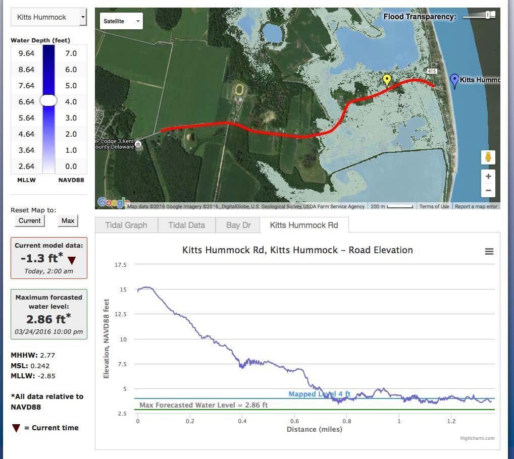
13 January 26, 2011 CoCoRAHS Observed Snowfall DEOS Observed Snowfall Official Delaware Snowfall
14 Data Usage Provide real-time and historical snow data to Delaware Department of Transportation for Snow Removal Reimbursement Program Provide real-time updates of snow data to public through DEOS website Also used heavily by DEMA for snow emergencies DEOS website traffic increase 10x during snow events
15 Take Away Real-time monitoring of snowfall is possible on a statewide level DEOS Network fills a large snow data gap in Delaware and provides a uniform system for measurement DEOS Storm Totals comparable to other networks Network has research potential


16 Delaware Coastal Hazards Elevation: Highest: 447 ft Lowest: Sea Level Mean: 60 ft Delaware coastal hazards and associated risks Source: DE SeaGrant Coastal Hazards Overview *(US Census Population Estimates Program v2015)

17 Mother s Day Storm 2008 May 12 th, 2008 Nor easter and astronomically high tides caused significant coastal flooding Evacuations at Slaughter Beach, Kitts Hummock, Bowers Beach, and Woodland Beach
18 Becoming more prepared! Can we give people more time? Can we better predict and inform people on where the flooding might occur and how bad it might be?
 ocean and weather forecast models Dissemination Packages the many diverse data inputs in a way that users can employ for realtime storm")
19 Integration Integrates many forms of environmental data including: weather obs. tidal level obs. elevation (lidar) ocean and weather forecast models Dissemination Packages the many diverse data inputs in a way that users can employ for realtime storm events. Also issues ALERTS to notify users of impending hazards.

20 Information is supplied concerning potential coastal flooding, tidallevel timing and height, maximum forecasted water level, etc

21 It is possible to drill down to the level of a single house, or an evacuation roadway.
22


23 Thanks to the following State Climate Office staff for their work on many of these products! Kevin Brinson DEOS Director Linden Wolf DEOS Chris Hughes DEOS Tina Callahan DEMAC David Huntley DEOS Matthew Shatley Computer Specialist
24 Thank You!
John Callahan (Delaware Geological Survey) Kevin Brinson, Daniel Leathers, Linden Wolf (Delaware Environmental Observing System)
 Kevin Brinson, Daniel Leathers, Linden Wolf (Delaware Environmental Observing System)") John Callahan (Delaware Geological Survey) Kevin Brinson, Daniel Leathers, Linden Wolf (Delaware Environmental Observing System) Delaware is extremely vulnerable to the impacts of coastal flooding Tropical
John Callahan (Delaware Geological Survey) Kevin Brinson, Daniel Leathers, Linden Wolf (Delaware Environmental Observing System) Delaware is extremely vulnerable to the impacts of coastal flooding Tropical
18.10 DEOS: The Delaware Environmental Observing System
 18.10 DEOS: The Delaware Environmental Observing System David R. Legates 1, Daniel J. Leathers 1, Tracy L. DeLiberty 1, Geoff E. Quelch 1, Kevin Brinson 1, Jason Butke 1, Rezaul Mahmood 2, and Stuart A.
The Delaware Environmental Monitoring & Analysis Center
 The Delaware Environmental Monitoring & Analysis Center Tina Callahan Delaware Estuary Science & Environmental Summit 2013 January 27-30, 2013 What is DEMAC? Delaware Environmental Monitoring & Analysis
NOAA s National Weather Service Philadelphia/Mt. Holly NJ
 Snow and Coastal Flooding through this evening Hazards and Impacts: Coastal Flooding: With the persistent onshore flow, and a new moon yesterday, coastal flooding is expected at high tide today. Moderate
Hurricane Preparation and Recovery. October 11, 2011 Jon Nance, Chief Engineer, NCDOT
 Hurricane Preparation and Recovery October 11, 2011 Jon Nance, Chief Engineer, NCDOT North Carolina & Severe Weather Our state often bears the brunt of storms, which include: Ice storms Snow storms Heavy
B.2 Sources for Hazard Identification, Profiling, and Ranking (Section 3) Overview of Sussex County s History of Hazards
 Overview of Sussex County s History of Hazards") Appendix B Sources B.1 Sources for Planning Process (Section 2) FEMA. Mitigation Planning Guidance (386 Series). Available on the web at: http://www.fema.gov/plan/mitplanning/planning_resources.shtm FEMA
Appendix B Sources B.1 Sources for Planning Process (Section 2) FEMA. Mitigation Planning Guidance (386 Series). Available on the web at: http://www.fema.gov/plan/mitplanning/planning_resources.shtm FEMA
John Laznik 273 Delaplane Ave Newark, DE (302)
") Office Address: John Laznik 273 Delaplane Ave Newark, DE 19711 (302) 831-0479 Center for Applied Demography and Survey Research College of Human Services, Education and Public Policy University of Delaware
Office Address: John Laznik 273 Delaplane Ave Newark, DE 19711 (302) 831-0479 Center for Applied Demography and Survey Research College of Human Services, Education and Public Policy University of Delaware
The Kentucky Mesonet: Entering a New Phase
 The Kentucky Mesonet: Entering a New Phase Stuart A. Foster State Climatologist Kentucky Climate Center Western Kentucky University KCJEA Winter Conference Lexington, Kentucky February 9, 2017 Kentucky
NOAA s National Weather Service Philadelphia/Mt. Holly NJ
 Early Week Coastal Flooding and snow Hazards and Impacts: Coastal Flooding: With the persistent onshore flow, and a new moon today, coastal flooding is expected at high tide through Tuesday morning. Moderate
United States Multi-Hazard Early Warning System
 United States Multi-Hazard Early Warning System Saving Lives Through Partnership Lynn Maximuk National Weather Service Director, Central Region Kansas City, Missouri America s s Weather Enterprise: Protecting
Analysis of Tides and Storm Surge from Observational Records in the Delaware Inland Bays
 Analysis of Tides and Storm Surge from Observational Records in the Delaware Inland Bays John Callahan Delaware Geological Survey Coastal GeoTools Conference March 30 April 2, 2015 Charleston, SC Outline
WHAT HAPPENS WHEN A TORNADO STRIKES THE COMMUNITY? Carroll County Sheriff s Office Emergency Management
 WHAT HAPPENS WHEN A TORNADO STRIKES THE COMMUNITY? Carroll County Sheriff s Office Emergency Management WHAT IS EMERGENCY MANAGEMENT? Carroll County Sheriff s Office Emergency Management Agency is responsible
Approved by: A. Cherrie Epps, Ph.D., President and Chief Executive Officer
 Page 1 of 5 Retired: Revised: Approved by: A. Cherrie Epps, Ph.D., President and Chief Executive Officer Subject: Office of General Counsel/Compliance - Inclement Weather and Emergency Closing Policy PURPOSE:
5.2 IDENTIFICATION OF HAZARDS OF CONCERN
 5.2 IDENTIFICATION OF HAZARDS OF CONCERN 2015 HMP Update Changes The 2010 HMP hazard identification was presented in Section 6. For the 2015 HMP update, the hazard identification is presented in subsection
Complete Weather Intelligence for Public Safety from DTN
 Complete Weather Intelligence for Public Safety from DTN September 2017 White Paper www.dtn.com / 1.800.610.0777 From flooding to tornados to severe winter storms, the threats to public safety from weather-related
Real-Time Flood Forecasting Modeling in Nashville, TN utilizing HEC-RTS
 Real-Time Flood Forecasting Modeling in Nashville, TN utilizing HEC-RTS Brantley Thames, P.E. Hydraulic Engineer, Water Resources Section Nashville District, USACE August 24, 2017 US Army Corps of Engineers
Chantale Bijoux Meteorological Officer
 Chantale Bijoux Meteorological Officer Introduction The Seychelles s National Meteorological Services plays a vital role in providing weather and climate information including severe weather changes, therefore
Storm Surge Analysis Update Meeting Cross City, Florida June 17, 2014
 Big Bend Coastal Storm Surge Study Storm Surge Analysis Update Meeting Cross City, Florida June 17, 2014 Introductions Risk MAP Project Team FEMA Region IV Florida Division of Emergency Management (FDEM)
5.2 IDENTIFICATION OF HAZARDS OF CONCERN
 5.2 IDENTIFICATION OF HAZARDS OF CONCERN 2016 HMP Update Changes The 2011 HMP hazard identification was presented in Section 3. For the 2016 HMP update, the hazard identification is presented in subsection
Nor easter Monday Night Wednesday December 8 10, 2014
 Nor easter Monday Night Wednesday December 8 10, 2014 Prepared 400 PM EST Monday, December 8, 2014 Mitchell Gaines NOAA s Philadelphia/Mount Holly NJ Forecast Office www.weather.gov/phi/ Purpose of Briefing
USGS Flood Inundation Mapping of the Suncook River in Chichester, Epsom, Pembroke and Allenstown, New Hampshire
 USGS Flood Inundation Mapping of the Suncook River in Chichester, Epsom, Pembroke and Allenstown, New Hampshire NH Water & Watershed Conference Robert Flynn, USGS NH-VT Water Science Center March 23, 2012
The Use of Geographic Information Systems (GIS) by Local Governments. Giving municipal decision-makers the power to make better decisions
 by Local Governments. Giving municipal decision-makers the power to make better decisions") The Use of Geographic Information Systems (GIS) by Local Governments Giving municipal decision-makers the power to make better decisions Case Study: Examples of GIS Usage by Local Governments in North
The Use of Geographic Information Systems (GIS) by Local Governments Giving municipal decision-makers the power to make better decisions Case Study: Examples of GIS Usage by Local Governments in North
Spatial Optimization of CoCoRAHS Network in Tennessee. Joanne Logan Department of Biosystems Engineering and Soil Science University of Tennessee
 Spatial Optimization of CoCoRAHS Network in Tennessee Joanne Logan Department of Biosystems Engineering and Soil Science University of Tennessee Abstract CoCoRaHS (Community Collaborative Rain, Hail and
Progress Report. Flood Hazard Mapping in Thailand
 Progress Report Flood Hazard Mapping in Thailand Prepared By: Mr. PAITOON NAKTAE Chief of Safety Standard sub-beuro Disaster Prevention beuro Department of Disaster Prevention and Mitigation THAILAND E-mail:
Weather versus Climate: What is the difference? Sources of Weather Information
 Joel O. Paz, Extension Agrometerologist and Gerrit Hoogenboom, Professor & REI Coordinator Department of Biological and Agricultural Engineering Weather versus Climate: What is the difference? The difference
National Weather Service Flood Forecast Needs: Improved Rainfall Estimates
 National Weather Service Flood Forecast Needs: Improved Rainfall Estimates Weather Forecast Offices Cleveland and Northern Indiana Ohio River Forecast Center Presenter: Sarah Jamison, Service Hydrologist
CATEX Hurricane Zachary
 CATEX Hurricane Zachary EXERCISE, EXERCISE,EXERCISE East Coast CATEX Power Restoration Functional Exercise 2013 This document was prepared under a grant from FEMA's Grants Programs Directorate, U.S. Department
Coastal Inundation Forecasting Demonstration Project CIFDP. Flood Forecasting Initiative-Advisory Group (FFI-AG 3), Geneva, 5-7 Dec, 2017
, Geneva, 5-7 Dec, 2017") Coastal Inundation Forecasting Demonstration Project CIFDP Flood Forecasting Initiative-Advisory Group (FFI-AG 3), Geneva, 5-7 Dec, 2017 Coastal Flooding & Vulnerable Populations Coastal populations are
Coastal Inundation Forecasting Demonstration Project CIFDP Flood Forecasting Initiative-Advisory Group (FFI-AG 3), Geneva, 5-7 Dec, 2017 Coastal Flooding & Vulnerable Populations Coastal populations are
Speakers: NWS Buffalo Dan Kelly and Sarah Jamison, NERFC Jeane Wallace. NWS Flood Services for the Black River Basin
 Speakers: NWS Buffalo Dan Kelly and Sarah Jamison, NERFC Jeane Wallace NWS Flood Services for the Black River Basin National Weather Service Who We Are The National Oceanic and Atmospheric Administration
Summary of Available Datasets that are Relevant to Flood Risk Characterization
 Inter-Agency Characterization Workshop February 25-27, 2014 USACE Institute for Water Resources, Alexandria, VA, IWR Classroom Summary of Available Datasets that are Relevant to Characterization National
HURRICANE MATTHEW A GIS PERSPECTIVE GLYNN COUNTY GIS
 HURRICANE MATTHEW A GIS PERSPECTIVE GLYNN COUNTY GIS Situation September 25 th October 9 th 2016 Hurricane Matthew tracked its way up the east coast bringing hurricane force winds and flooding from Haiti
NOAA s National Weather Service Philadelphia/Mt. Holly NJ. Summary. Changes
 Summary A crippling and potentially historic east coast snow storm will lead to blizzard conditions and major coastal flooding for portions of the area this weekend. Changes Blizzard Warning has been expanded
JCOMM-CHy Coastal Inundation Forecasting Demonstration Project (CIFDP)
") WMO World Meteorological Organization Working together in weather, climate and water JCOMM-CHy Coastal Inundation Forecasting Demonstration Project (CIFDP) Coastal Flooding & Vulnerable Populations Coastal
WMO World Meteorological Organization Working together in weather, climate and water JCOMM-CHy Coastal Inundation Forecasting Demonstration Project (CIFDP) Coastal Flooding & Vulnerable Populations Coastal
Storm Surge/Coastal Inundation State of the Union. Jamie Rhome Storm Surge Team Lead NOAA/National Hurricane Center
 Storm Surge/Coastal Inundation State of the Union Jamie Rhome Storm Surge Team Lead NOAA/National Hurricane Center 2 Tampa: Cat 5 Scenario 3 4 The Stakes are High Combination of SLR and increasing coastal
MUNICIPALITY OF ANCHORAGE PUBLIC TRANSPORTATION DEPARTMENT AnchorRIDES TRANSPORTATION SYSTEM
 Purpose: The Public Transportation Department and contracted provider will provide safe transportation for AnchorRIDES customers and employees during severe weather or emergency conditions. AnchorRIDES
NWSEO CALLS FOR NATIONAL CLIMATE SERVICE TO BE MADE PART OF THE NATIONAL WEATHER SERVICE
 APRIL 2009 NWSEO CALLS FOR NATIONAL CLIMATE SERVICE TO BE MADE PART OF THE NATIONAL WEATHER SERVICE At its recent winter meeting, the NWSEO National Council decided to urge the Administration and Congress
NOAA Inundation Dashboard
 NOAA Inundation Dashboard Audra Luscher & Paul Fanelli NOS Center for Operational Oceanographic Products & Services (CO-OPS) Hampton Roads Sea Level Rise/Flooding Adaptation Forum July 29, 2016 http://tidesandcurrents.noaa.gov/inundationdb/newyork.html
NOAA S2S Planning. Dave DeWitt Fred Toepfer
 NOAA S2S Planning Dave DeWitt Fred Toepfer 1 Agenda 1. Brief synopsis of The Weather Research and Forecasting Act of 2017 2. Report to Congress a. Timeline b. Process c. Document Outline 3. Some Preliminary
Snow Tonight and Sunday
 Snow Tonight and Sunday Decision Support Briefing #4 As of 4:00 PM Saturday, Jan. 12, 2019 What Has Changed? Winter Storm Warning has been issued for portions of Delmarva and the Winter Weather Advisory
Emerging Needs, Challenges and Response Strategy
 Emerging Needs, Challenges and Response Strategy Development of Integrated Observing Systems in China JIAO Meiyan Deputy Administrator China Meteorological Administration September 2011 Geneva Outline
The WeatherShare Project: Aggregation and Dissemination of Weather Information for Public Safety
 slide1 The WeatherShare Project: Aggregation and Dissemination of Weather Information for Public Safety National Rural ITS Conference 2006 Big Sky Montana Monday, August 14th, 2006 12:30 pm Session B4:
Geospatial natural disaster management
 Geospatial natural disaster management disasters happen. are you ready? Natural disasters can strike almost anywhere at any time, with no regard to a municipality s financial resources. These extraordinarily
Monitoring Scour Critical Bridges During Floods For Local Bridge Owners. Presented by
 Monitoring Scour Critical Bridges During Floods For Local Bridge Owners Presented by SAFETY FIRST DO NOT ENDANGER YOURSELF OR OTHERS WHILE MONITORING BRIDGES DO NOT ENTER FLOOD WATERS FLOOD WATERS INCLUDE
The Delaware Environmental Observing System. A Real-Time System Dedicated to Monitoring Environmental Conditions Across Delmarva
 The Delaware Environmental Observing System A Real-Time System Dedicated to Monitoring Environmental Conditions Across Delmarva Delaware Solid Waste Authority Dept of Natural Resources nd Environmental
National Public Weather and Warning Services in the Swaziland Meteorological Service Dennis S.Mkhonta /
 National Public Weather and Warning Services in the Swaziland Meteorological Service Dennis S.Mkhonta dennis.mkhonta@gmail.com / dennis@swazimet.gov.sz Introduction Swaziland s geographical position exposes
 Hazard Warnings GE 4150 Natural Hazards September 17, 2007 http://www.sdr.gov/ndis_rev_oct27.pdf Sorensen, J.H. (2000) Hazard warning systems: Review of 20 years of progress. Natural Hazards Review, May,
OnTheMap for Emergency Management
 OnTheMap for Emergency Management Robert Pitts Geographer/Project Manager Longitudinal Employer Household Dynamics (LEHD) Center for Economic Studies U.S. Census Bureau Jody Hoon-Star Geographer/Application
Flash Flood Guidance System On-going Enhancements
 Flash Flood Guidance System On-going Enhancements Hydrologic Research Center, USA Technical Developer SAOFFG Steering Committee Meeting 1 10-12 July 2017 Jakarta, INDONESIA Theresa M. Modrick Hansen, PhD
Exercise Brunswick ALPHA 2018
 ALPHA Exercise Brunswick ALPHA 2018 Who we are (our structure) What we do (our forecasts) How you can access the information Tropical cyclone information (basic) Overview of the products used for Exercise
Unit 5: NWS Hazardous Weather Products. Hazardous Weather and Flooding Preparedness
 Unit 5: NWS Hazardous Weather Products Objectives Describe the mission of the NWS Describe the basic organizational structure of the NWS Explain the purpose of various NWS products Explain how Probability
DEVELOPMENT OF A FORECAST EARLY WARNING SYSTEM ethekwini Municipality, Durban, RSA. Clint Chrystal, Natasha Ramdass, Mlondi Hlongwae
 DEVELOPMENT OF A FORECAST EARLY WARNING SYSTEM ethekwini Municipality, Durban, RSA Clint Chrystal, Natasha Ramdass, Mlondi Hlongwae LOCATION DETAILS AND BOUNDARIES ethekwini Municipal Area = 2297 km 2
Floodplain Mapping & Flood Warning Applications in North Carolina
 Floodplain Mapping & Flood Warning Applications in North Carolina Marc Stanard, IT Project Manager Ken Ashe, Assistant Director David Herlong, Flood Warning Program Manager NC Crime Control & Public Safety
Nurture Nature Center Receives Grant From National Oceanic and Atmospheric Administration To Study Flood Forecast and Warning Tools
 Nurture Nature Center Receives Grant From National Oceanic and Atmospheric Administration To Study Flood Forecast and Warning Tools One of four national awards by National Weather Service to advance weather
Hurricane Readiness for Coastal Communities
 Hurricane Readiness for Participant Guide Developed for: Federal Emergency Management Agency Emergency Management Institute 16825 South Seton Avenue Emmitsburg, MD 21727-8998 Developed by: C² Technologies,
Understanding Weather and Climate Risk. Matthew Perry Sharing an Uncertain World Conference The Geological Society, 13 July 2017
 Understanding Weather and Climate Risk Matthew Perry Sharing an Uncertain World Conference The Geological Society, 13 July 2017 What is risk in a weather and climate context? Hazard: something with the
PUBLIC SAFETY POWER SHUTOFF POLICIES AND PROCEDURES
 PACIFIC GAS AND ELECTRIC COMPANY PUBLIC SAFETY POWER SHUTOFF POLICIES AND PROCEDURES SEPTEMBER 2018 1 PACIFIC GAS AND ELECTRIC COMPANY PUBLIC SAFETY POWER SHUTOFF POLICIES AND PROCEDURES SEPTEMBER 2018
NWS Resources For Public Works
 NWS Resources For Public Works August 28th, 2016 Shawn DeVinny shawn.devinny@noaa.gov Meteorologist National Weather Service Twin Cities/Chanhassen, MN 1 APWA 2016 PWX 8/28/2016 National Weather Service
Landslide monitoring system in Iceland. Harpa Grímsdóttir Jón Kristinn Helgason NVE, Oslo, October
 Landslide monitoring system in Iceland Harpa Grímsdóttir Jón Kristinn Helgason NVE, Oslo, October 26 2016 History Avalanches and landslides have caused extensive damages and loss of human lives in Iceland
WMO/WWRP FDP: INCA CE
 WMO/WWRP FDP: INCA CE Yong Wang ZAMG, Austria This project is implemented through the CENTRAL EUROPE Programme co-financed by the ERDF INCA CE: implementation over Central Europe A Nowcasting Initiative
5.2 IDENTIFICATION OF HAZARDS OF CONCERN
 5.2 IDENTIFICATION OF HAZARDS OF CONCERN 2016 HMP Update Changes The 2011 HMP hazard identification was presented in Section 3. For the 2016 HMP update, the hazard identification is presented in subsection
COASTAL DATA APPLICATION
 2015 Coastal GeoTools Proactive By Design. Our Company Commitment COASTAL DATA APPLICATION Projecting Future Coastal Flood Risk for Massachusetts Bay Bin Wang, Tianyi Liu, Daniel Stapleton & Michael Mobile
Monitoring Extreme Weather Events. February 8, 2010
 Monitoring Extreme Weather Events February 8, 2010 Extensive network of over 800 stations across the Prairies Good coverage across entire agriculture production region Network of networks strategy includes
From Vulnerability to Resilience And the Tools to Get There. Out of Harm s Way Partnership for the Delaware Estuary August 1, 2012
 From Vulnerability to Resilience And the Tools to Get There Out of Harm s Way Partnership for the Delaware Estuary August 1, 2012 Today s Presentation Tour of New Jersey Challenges Definitions so we re
Folsom Dam Water Control Manual Update
 Folsom Dam Water Control Manual Update Public Workshop April 3, 2014 Location: Sterling Hotel Ballroom 1300 H Street, Sacramento US Army Corps of Engineers BUILDING STRONG WELCOME & INTRODUCTIONS 2 BUILDING
Weather briefing Strong Coastal Nor easter November 7 th -8 th, 2012
 Weather briefing Strong Coastal Nor easter November 7 th -8 th, 2012 Prepared 1215 PM EDT Wednesday November 7, 2012 Gary Szatkowski NOAA s NJ Forecast Office http://www.erh.noaa.gov/phi/ Purpose of Briefing
CLIMATE SERVICES for the AGRICUTURAL SECTOR in the PHILIPPINES
 CLIMATE SERVICES for the AGRICUTURAL SECTOR in the PHILIPPINES EDNA L. JUANILLO Weather Services Chief, PAGASA Technical Conference on Future Challenges and Opportunities in Agricultural Meteorology 16-17
ÖBB Natural Hazard Management
 ÖBB Natural Hazard Management Management of Weather Events in the Austrian Federal Railways MOWE-IT, Brussels 17 th of September 2013 DI Günther Kundela Integrated Track Management Integration Technic
A Cloud-Based Flood Warning System For Forecasting Impacts to Transportation Infrastructure Systems
 A Cloud-Based Flood Warning System For Forecasting Impacts to Transportation Infrastructure Systems Jon Goodall Associate Professor, Civil and Environmental Engineering Associate Director, Link Lab April
BOWIE SENIORS COMPUTER CLUB
 BOWIE SENIORS COMPUTER CLUB Meeting Minutes for May 5, 2016 Through the efforts of Program Chairman Dan Lee, we had Patrick T. Callahan, GIS Manager of the Prince George's County Office of Information
EMERGENCY WARNING SYSTEM PROCEDURES FOR DEBRIS FLOWS IN WESTERN OREGON
 EMERGENCY WARNING SYSTEM PROCEDURES FOR DEBRIS FLOWS IN WESTERN OREGON Updated: 12/03/2007 by the Oregon Department of Forestry and the Oregon Department of Geology and Mineral Industries Debris flows
INCA CE: Integrating Nowcasting with crisis management and risk prevention in a transnational framework
 INCA CE: Integrating Nowcasting with crisis management and risk prevention in a transnational framework Yong Wang ZAMG, Austria This project is implemented through the CENTRAL EUROPE Programme co-financed
DRAFT - Tsunami Response Plan Playbook Santa Cruz Harbor Maritime Community
 DRAFT - Tsunami Response Plan Playbook Santa Cruz Harbor Maritime Community Page 1 Best to display on 11X17 paper Purpose and Use of this Real-time Tsunami Response Plan Playbook PURPOSE: This product
Tropical Update. 5 AM EDT Tuesday, September 12, 2017 Post-Tropical Cyclone Irma, Hurricane Jose, & Tropical Wave (10%)
") Tropical Update 5 AM EDT Tuesday, September 12, 2017 Post-Tropical Cyclone Irma, Hurricane Jose, & Tropical Wave (10%) This update is intended for government and emergency response officials, and is provided
Tropical Update 5 AM EDT Tuesday, September 12, 2017 Post-Tropical Cyclone Irma, Hurricane Jose, & Tropical Wave (10%) This update is intended for government and emergency response officials, and is provided
ICE STORM! a mini tabletop exercise for home care agencies
 1 ICE STORM! a mini tabletop exercise for home care agencies HCA Education and Research Winter 2010 2011 2 What is a tabletop exercise? People come together to review and discuss a hypothetical emergency
Weather Information for Road Managers
 Weather Information for Road Managers by Paul A. Pisano, Lynette C. Goodwin and Andrew D. Stern How Does Weather Affect Roads? The complex interactions between weather and roads have major affects on traffic
Improving global coastal inundation forecasting WMO Panel, UR2014, London, 2 July 2014
 Improving global coastal inundation forecasting WMO Panel, UR2014, London, 2 July 2014 Cyclone Sidr, November 2007 Hurricane Katrina, 2005 Prof. Kevin Horsburgh Head of marine physics, UK National Oceanography
GIS DISASTER MAPPING TO UPDATE WARNING SYSTEMS
 POSTER SESSIONS 309 GIS DISASTER MAPPING TO UPDATE WARNING SYSTEMS UTEJ. DYMON DEPT. OF GEOGRAPHY KENT STATE UNIVERSITY KENT, OHIO 44242-0001, USA DYMON@HUMBOLDT.KENT.EDU FAX (216) 672-4304 ABSTRACT The
WMO Welcome Statement
 WMO Welcome Statement at the Opening of the WMO Symposium on Nowcasting and Very-short-range Forecast (Hong Kong, China, 25-29 July 2016) On behalf of Professor Petteri Taalas, Secretary-General of the
World Meteorological Organization Working together in weather, climate and water
 WMO World Meteorological Organization Working together in weather, climate and water Strengthening Regional Cooperation to Support Forecasting with Multi-Hazard Approach in RA IV SWFDP concepts and lessons
Inclement Weather Procedures November 2, 2016
 Inclement Weather Procedures November 2, 2016 Director of Operations Mr. Sidney Pinder Jr. Purpose To explain the process of how determines when to implement the following due to inclement weather: 90-Minute
MUNICIPALITY OF ANCHORAGE PUBLIC TRANSPORTATION DEPARTMENT AnchorRIDES PARATRANSIT SYSTEM
 Purpose: The Public Transportation Department (PTD) and AnchorRIDES paratransit contractor will provide transportation in as safe a manner as effectively possible. Paratransit vehicles primarily operate
教育啓蒙への利活用を考慮した防災技術情報アーカイブシステムの開発 (2013)
") Title Program 1 : Preparedness Program fo Impact Author(s) SOE, Aye Aye Citation 教育啓蒙への利活用を考慮した防災技術情報アーカイブシステムの開発 (2013) Issue Date 2013-06 URL http://hdl.handle.net/2433/175523 Right Type Article Textversion
Title Program 1 : Preparedness Program fo Impact Author(s) SOE, Aye Aye Citation 教育啓蒙への利活用を考慮した防災技術情報アーカイブシステムの開発 (2013) Issue Date 2013-06 URL http://hdl.handle.net/2433/175523 Right Type Article Textversion
IDENTIFICATION OF HAZARDS OF CONCERN
 IDENTIFICATION OF HAZARDS OF CONCERN To provide a strong foundation for mitigation strategies considered in Section 6, the Village considered a full range of hazards that could impact the area and then
VISIT MISSISSIPPI GULF COAST CRISIS COMMUNICATION MANUAL 2016
 VISIT MISSISSIPPI GULF COAST CRISIS COMMUNICATION MANUAL 2016 This manual was prepared for Visit Mississippi Gulf Coast staff in the event of a crisis, and will help to distinguish the appropriate course
GIS in Weather and Society
 GIS in Weather and Society Olga Wilhelmi Institute for the Study of Society and Environment National Center for Atmospheric Research WAS*IS November 8, 2005 Boulder, Colorado Presentation Outline GIS basic
Geospatial Data, Services, and Products. National Surveying, mapping and geospatial conference
 Geospatial Data, Services, and Products Federal Programs -- USDA NRCS National Surveying, mapping and geospatial conference March 15, 2016 NRCS Applications using Geosaptial Products & Services Field
Great Lakes Information Network GIS (Queryable by topic, geography, organization, and upload date 73 layers as of October, 2009)
") Google Earth Files for the Great Lakes and Beyond GLOS Mapping Workshop Alpena, Michigan November 9, 2009 David Hart GIS Specialist University of Wisconsin Sea Grant Institute GREAT LAKES Great Lakes Information
Google Earth Files for the Great Lakes and Beyond GLOS Mapping Workshop Alpena, Michigan November 9, 2009 David Hart GIS Specialist University of Wisconsin Sea Grant Institute GREAT LAKES Great Lakes Information
Weather Information for Surface Transportation (WIST): Update on Weather Impacts and WIST Progress
: Update on Weather Impacts and WIST Progress") Weather Information for Surface Transportation (WIST): Update on Weather Impacts and WIST Progress Samuel P. Williamson Office of the Federal Coordinator for Meteorological Services and Supporting Research
Weather Information for Surface Transportation (WIST): Update on Weather Impacts and WIST Progress Samuel P. Williamson Office of the Federal Coordinator for Meteorological Services and Supporting Research
WINTER STORM Annex II
 WINTER STORM Annex II I. PURPOSE A. This annex has been prepared to ensure a coordinated response by state agencies to requests from local jurisdictions to reduce potential loss of life and to ensure essential
Steven Chien Kung-E Cheng New Jersey Institute of Technology. David Bowlby New Jersey Department of Transportation
 Steven Chien Kung-E Cheng New Jersey Institute of Technology David Bowlby New Jersey Department of Transportation The 11th MDSS Stakeholder Meeting Charlotte, NC September 16, 2009 NJ-MDSS Goals Improve
National Weather Service. Building a Weather Ready Nation
 National Weather Service Building a Weather Ready Nation The NWS is a federal agency Department of Commerce National Oceanic and Atmospheric Administration National Weather Service Today s National Weather
Storm Surge Forecasting and Warning in the Philippines
 Storm Surge Forecasting and Warning in the Philippines 3 rd Masterclass on Disaster Mitigation APAN46 Asia Pacific Advanced Network Meeting 08 August 2018 Jehan Fe S. Panti PAGASA-DOST jspanti@pagasa.dost.gov.ph
NOAA Surface Weather Program
 NOAA Surface Weather Program Maintenance Decision Support System Stakeholder Meeting #9 Jim O Sullivan NOAA Surface Weather Program Manager NWS Office of Climate, Water, and Weather Services September
Miami-Dade County Overview
 Miami-Dade County Overview 2,000 square miles World s busiest cruise port 2.6 million residents Second busiest US airport for international travelers Gateway to the Caribbean and Latin America Natural
2018 VACO Achievement Awards Nomination Summary York County, Virginia. In 2017, the York County Department of Fire and Life Safety/Office of
 2018 VACO Achievement Awards Nomination Summary York County, Virginia Program Title: Significant Event Briefing Dashboard Program Category: Criminal Justice & Public Safety Program Overview: In 2017, the
A Prepared Marylander Creates a Resilient Maryland
 Maryland Emergency Management Agency Operations Directorate Hazardous Winter Weather Outlook Briefing March 5, 2013 0800 A Prepared Marylander Creates a Resilient Maryland A strong low pressure will track
Chippewa County Natural Hazards Mitigation Plan
 2014 Chippewa County Natural Hazards Mitigation Plan Prepared for: Chippewa County Office of Emergency Management With the Assistance of: Eastern U.P. Regional Planning & Development Commission April,
Caribbean Early Warning System Workshop
 Caribbean Early Warning System Workshop Hamonization in Existing EWS April 14-16, 2016 Presenter: Shawn Boyce Caribbean Institute for Meteorology and Hydrology Husbands, St. James Barbados Background Between
Norwegian spatial data infrastructure supporting disaster risk management Norwegian Mapping Authority
 Norwegian spatial data infrastructure supporting disaster risk management Norwegian Mapping Authority Arvid Lillethun, Norwegian Mapping Authority Land and Poverty 2018 Conference, World Bank 19.-23. March
Glossary. ARC: American Red Cross. ASOS: Automated Surface Observing System (NWS & FAA) ATM: Abbreviated Transportation Model
 ATM: Abbreviated Transportation Model") A AFN Access and Functional Needs. People who may have additional needs before, during, and after an incident in functional areas, including but not limited to: maintaining independence, communication,
A AFN Access and Functional Needs. People who may have additional needs before, during, and after an incident in functional areas, including but not limited to: maintaining independence, communication,