BOWIE SENIORS COMPUTER CLUB
|
|
|
- Geoffrey Blair
- 6 years ago
- Views:
Transcription
1 BOWIE SENIORS COMPUTER CLUB Meeting Minutes for May 5, 2016 Through the efforts of Program Chairman Dan Lee, we had Patrick T. Callahan, GIS Manager of the Prince George's County Office of Information Technology as our guest speaker for this meeting. Mr. Callahan s presentation was about Prince George s County s Geographical Information System. A geographic information system (GIS) is a computer system for capturing, storing, checking, and displaying data related to positions on Earth's surface. These programs can show many different kinds of data on one map (such as: emergency data, environmental data, demographic data, archeological data, etc). This enables government organizations all levels to more easily see, analyze, and understand patterns and relationships. Prince George s County s GIS has been developed with a special emphasis on emergency response capabilties. Copies of Mr. Callahan s slides are attached. The meeting included an interesting question and answer session. It was very informative and well-attended meeting. Bill Long, Secretary

2 Prince George s County Office of Information Technology-GIS Patrick Callahan GIS Manager May 5 th, 2016

3 What is GIS? Geographic Information Systems (GIS) is a technological field that incorporates geographical features with tabular data in order to map, analyze, and assess real-world problems. The key word to this technology is Geography this means that some portion of the data is spatial, or data that is in some way referenced to locations on the earth. Coupled with this data is tabular data known as attribute data. Attribute data can be defined as additional information about each of the spatial features.

4 What is GIS?

5 Simple Terms: Links databases and maps So, What is GIS? Manages information about places Helps answer questions such as: Where is it? What else is nearby? Where is the highest concentration of X? Where can I find things with characteristic Y? Where is the closest Z to my location?
6 Why use GIS in Local Government? 80% of Local government activities estimated to be geographically based plats, zoning, public works (streets, water supply, sewers), garbage collection, land ownership and valuation, public safety (fire and police) A GIS provides an efficient method for the maintenance and storage of maps. Patterns, trends and relationships are identified and spatially analyzed.

7 Prince George s County GIS Uses Fire Chief needs to make sure that he has complete Fire/EMS coverage of the County Need to find stations that overlap other station coverage areas Find gaps in Fire/EMS Coverage based on a 7 minute drive time area Use calls for service data
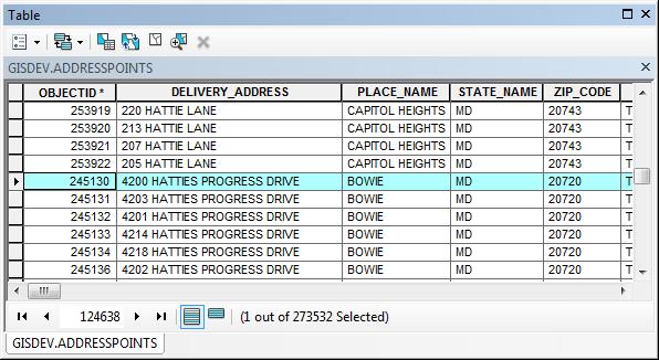
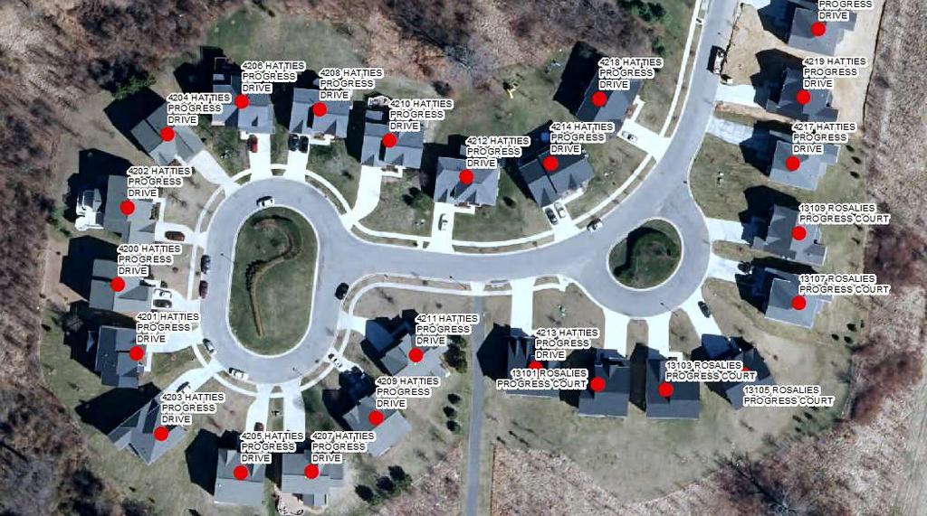
8 Prince George s County GIS Uses 1. Convert that text file into a spatial feature class How? Geocoding
 and spatially locating on the earth.")
9 Geocoding Geocoding Process of taking any geographic related data (Address or Zip Code) and spatially locating on the earth. Example: 9201 Basil Court, Largo, MD 20774

10 Prince George s County GIS Uses 1. Convert that text file into a spatial feature class 2. Density (Hotspot) Map

11 Prince George s County GIS Uses 1. Convert that text file into a spatial feature class 2. Density (Hotspot) Map

12 resentation Fire Department Coverage: 7 minute drive time from each fire station Gray No coverage Green 1 Station Red - 15 Stations

13 Firebox Population Number of Calls
 GIS Manager 2 GIS Web")

14 Prince George s County GIS Rushern L. Baker, III County has disseminated GIS Enterprise structure 4 person OIT-GIS team (Core GIS) GIS Manager 2 GIS Web and Applications Developers GIS Database Administrator Agency GIS (Specialty GIS) Users in the different agencies use GIS as a tool to help them in their core business GIS Specialists in their field 400 GIS users in the agencies MNCPPC has it s own GIS department and system, which is separate from OIT-GIS
15 Core GIS Central repository for all GIS data Manage the GIS Enterprise infrastructure Point of contact for all GIS related projects County agency projects Regional projects (INDEX, Geospatial Data Exchange, MEMA incident exchange, ICBN) Provide new GIS technology solutions Map and web services Mobile applications GPS technology
16 Core GIS Provide GIS support to agencies without GIS trained staff 75 map projects with over 300 maps a year 18 Map Applications (Internal/External users) Data analysis Fire/EMS run time maps Low to moderate income level location analysis Foreclosure rate maps Proposed and Approved CIP Budget Books Homeland Security/Public Safety GIS is a core product of the 911 system EOC support during emergencies


: GIS Subcommittee")
17 Core GIS Point of Contact for Regional and Statewide Events Maryland State Geographic Information Committee (MSGIC): Executive Committee Member MWCOG CIO Committee: GIS Subcommittee Executive Member INDEX and Geospatial Data Exchange Executive member FEMA Region III Regional Interagency Steering Committee(RISC): GIS Subcommittee member


18 Recent GIS Projects Fire/EMS: Adopt A Neighborhood Program


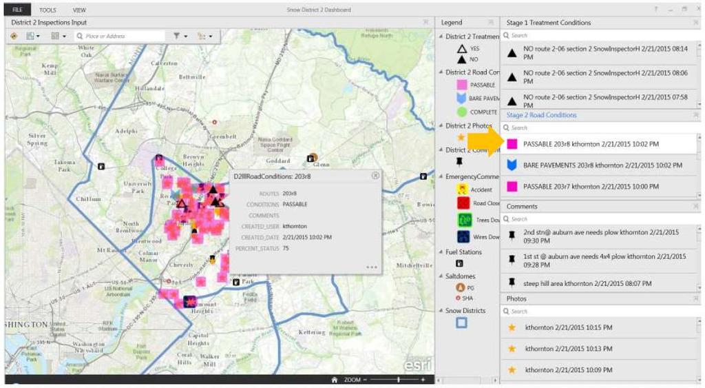
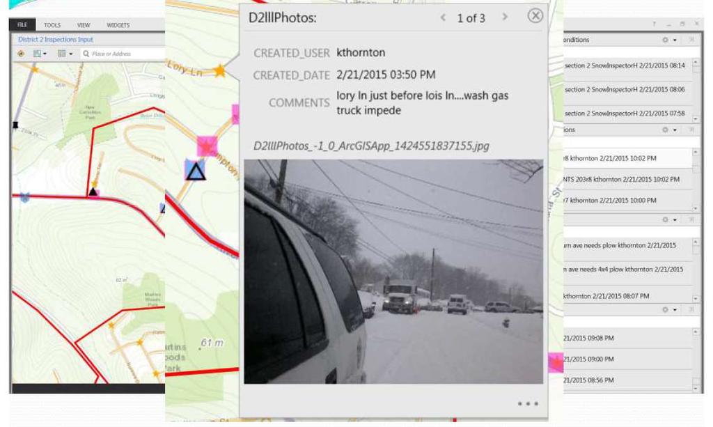
19 Recent GIS Projects DPWT: Snow Plow Inspection Application


20 Recent GIS Projects Board of Elections County Polling Places and Elected Officials Two Sites Early Voting Sites Polling Places and Elected Officials
21 Current GIS Projects National Pollutant Discharge Elimination System (NPDES) Permit for discharging of Pollutants into waters of the United States Monitoring and Inspection system for Stormwater Management GIS Based reporting system Transforming Neighborhood Initiative (TNI): Story Map Allows the public to see and learn more of the 6 TNI locations the has chosen to focus Government resources

22 Current GIS Projects Prince George s County Visitor s site:


23 County Website Prince George s County Website

24 MNCPPC PGAtlas Maryland National Capitial Park and Planning Commission PGAtlas Site:


25 Questions? Rushern L. Baker, III Patrick Callahan Largo Government Center Suite 250 Largo, MD
KING GEORGE COUNTY DEPARTMENT OF COMMUNITY DEVELOPMENT
 GIS REPORT 2016 KING GEORGE COUNTY DEPARTMENT OF COMMUNITY DEVELOPMENT Background The GIS (Geographic Information System) coordinator was hired in 2001 to develop a GIS for King George County. Prior to
CHAPTER 22 GEOGRAPHIC INFORMATION SYSTEMS
 CHAPTER 22 GEOGRAPHIC INFORMATION SYSTEMS PURPOSE: This chapter establishes the administration and use of to improve the quality and accessibility of Department s spatial information and support graphical
Information. Information Technology. Geographic. Services (GIS) 119 W Indiana Ave Deland, FL 32720
 119 W Indiana Ave Deland, FL 32720") Information Technology Geographic Information Services (GIS) 119 W Indiana Ave Deland, FL 32720 A GIS consists of 5 primary components: Hardware Software People Data Methods or Business Processes --- Hardware
Information Technology Geographic Information Services (GIS) 119 W Indiana Ave Deland, FL 32720 A GIS consists of 5 primary components: Hardware Software People Data Methods or Business Processes --- Hardware
GIS = Geographic Information Systems;
 What is GIS GIS = Geographic Information Systems; What Information are we talking about? Information about anything that has a place (e.g. locations of features, address of people) on Earth s surface,
GIS Monroe Geographic Information System March 14, 2018
 GIS Monroe Geographic Information System March 14, 2018 Goals Maintain Enterprise/County-wide geo-database Increase spatial accuracy of data Build and acquire more data layers Increase use of GIS; as another
John Laznik 273 Delaplane Ave Newark, DE (302)
") Office Address: John Laznik 273 Delaplane Ave Newark, DE 19711 (302) 831-0479 Center for Applied Demography and Survey Research College of Human Services, Education and Public Policy University of Delaware
Office Address: John Laznik 273 Delaplane Ave Newark, DE 19711 (302) 831-0479 Center for Applied Demography and Survey Research College of Human Services, Education and Public Policy University of Delaware
D2E GIS Coordination Initiative Functional Transformation Kick-Off Meeting
 D2E GIS Coordination Initiative Functional Transformation Kick-Off Meeting GIS Functional Transformation Kick-Off Meeting May 13, 2008 D2E GIS Coordination Initiative Functional Transformation Kick-Off
Steve Pietersen Office Telephone No
 Steve Pietersen Steve.Pieterson@durban.gov.za Office Telephone No. 031 311 8655 Overview Why geography matters The power of GIS EWS GIS water stats EWS GIS sanitation stats How to build a GIS system EWS
OC Enterprise GIS. Kevin Hills, PLS Cameron Smith, GISP. OC Survey
 OC Enterprise GIS Kevin Hills, PLS Cameron Smith, GISP OC Survey Discussion Points Background & Organizational Structure of OCPW Past practices prior to Enterprise Wide GIS License (ELA) Participating
GIS. in the City of Lewiston Maine
 GIS in the City of Lewiston Maine The purpose of this slideshow is to provide an overview of the city GIS and how it is used, maintained and accessed in-house as well as by the public. Please simply hit
Rebuilding after Hurricane Katrina: Neighborhood Planning with a GIS Template
 Rebuilding after Hurricane Katrina: Neighborhood Planning with a GIS Template URPL 969 Applied GIS Workshop: Rethinking New Orleans After Hurricane Katrina Prof. David Hart University of Wisconsin-Madison
A GIS TOUR OF DES MOINES PRESENTED BY ANNA WHIPPLE, GIS MANAGER APRIL 20, 2015
 A GIS TOUR OF DES MOINES PRESENTED BY ANNA WHIPPLE, GIS MANAGER APRIL 20, 2015 Welcome to Des Moines! Capital of Iowa Among 100 largest metropolitan areas Insurance, biotech, healthcare, and entertainment
GIS ADMINISTRATOR / WEB DEVELOPER EVANSVILLE-VANDERBURGH COUNTY AREA PLAN COMMISSION
 GIS ADMINISTRATOR / WEB DEVELOPER EVANSVILLE-VANDERBURGH COUNTY AREA PLAN COMMISSION SALARY RANGE INITIATION $43,277 SIX MONTHS $45,367 POSITION GRADE PAT VI The Evansville-Vanderburgh County Area Plan
Creating a Staff Development Plan with Esri
 Creating a Staff Development Plan with Esri Michael Green David Schneider Guest Presenter: Shane Feirer, University of California Esri UC 2014 Technical Workshop Agenda What is a Staff Development Plan?
GIS Needs Assessment. for. The City of East Lansing
 GIS Needs Assessment for The City of East Lansing Prepared by: Jessica Moy and Richard Groop Center for Remote Sensing and GIS, Michigan State University February 24, 2000 Executive Summary At the request
KING GEORGE COUNTY DEPARTMENT OF COMMUNITY DEVELOPMENT
 GIS REPORT 2017 KING GEORGE COUNTY DEPARTMENT OF COMMUNITY DEVELOPMENT Background The GIS (Geographic Information System) manager was hired in 2001 to develop a GIS for King George County. Prior to 2001,
FHWA GIS Outreach Activities. Loveland, Colorado April 17, 2012
 FHWA GIS Outreach Activities Loveland, Colorado April 17, 2012 GIS for Improved Decision Making FHWA believes that geographic information systems and other geospatial technologies (remote sensing and GPS)
Tools to Assess Local Health Needs. Richard Leadbeater, Esri NACo 2011 Healthy Counties Forum December 1, 2011
 Tools to Assess Local Health Needs Richard Leadbeater, Esri NACo 2011 Healthy Counties Forum December 1, 2011 Richard Leadbeater currently holds the position of Industry Solutions Manager with Esri. He
Appendix A. City of East Lansing Interview Report
 Department: City Clerk Meeting Participants: Sue Donnell, City Clerk Data Provider: The City Clerk s office maintains and updates all voting and election data. These data include legislative, school, and
GIS Geographic Information Systems
 GIS Geographic Information Systems Connecting your Community Ruekert Mielke WAUKESHA WHO WE ARE DATE ESTABLISHED 1946 SERVING LOCAL PEOPLE. SOLVING LOCAL PROBLEMS. TYPE OF ORGANIZATION Ruekert & Mielke,
What s Happening in My Watershed?
 What s Happening in My Watershed? How Implementing a GIS system to Utilize Spatial Data and Digital Collection Techniques can help Solve Watershed Issues. Mindi J. Parsell City of Tulsa Stormwater Quality
GEOGRAPHIC INFORMATION SYSTEMS Session 8
 GEOGRAPHIC INFORMATION SYSTEMS Session 8 Introduction Geography underpins all activities associated with a census Census geography is essential to plan and manage fieldwork as well as to report results
IH 35 at Blanco River May 2015
 IH 35 at Blanco River May 2015 Presentation Objectives Background of historical damage assessment processes Introduction to Collector App ( Mat Peck) Collector App and Flood Damage Assessment (Katie Steele)
Crime Analysis. GIS Solutions for Intelligence-Led Policing
 Crime Analysis GIS Solutions for Intelligence-Led Policing Applying GIS Technology to Crime Analysis Know Your Community Analyze Your Crime Use Your Advantage GIS aids crime analysis by Identifying and
GIS Geographical Information Systems. GIS Management
 GIS Geographical Information Systems GIS Management Difficulties on establishing a GIS Funding GIS Determining Project Standards Data Gathering Map Development Recruiting GIS Professionals Educating Staff
WELCOME & INTRODUCTIONS
 GIS Monroe Geographic Information System January 31, 2018 WELCOME & INTRODUCTIONS Chip Thomas, Ritter GIS Sarah Schrader, Acct. Mgr., ESRI Chris Beyett, Solutions Engineer, ESRI Colleen Hinzmann, IT Director,
FIRE DEPARMENT SANTA CLARA COUNTY
 DEFINITION FIRE DEPARMENT SANTA CLARA COUNTY GEOGRAPHIC INFORMATION SYSTEM (GIS) ANALYST Under the direction of the Information Technology Officer, the GIS Analyst provides geo-spatial strategic planning,
The Delaware Environmental Observing System
 The Delaware Environmental Observing System DECISION SUPPORT FOR COASTAL FLOODING AND SNOWFALL Daniel Leathers, State Climatologist, Professor University of Delaware Tina Callahan, DEMAC, University of
GIS for Planning and Revenue Collection
 GIS for Planning and Revenue Collection Laban Karanja & Barbara Seje GIS for County Government Seminar Agenda Introduction County goals County Challenges GIS as a solution for County challenges What Counties
USEPA's Comprehensive Geospatial Information Sharing Framework
 USEPA's Comprehensive Geospatial Information Sharing Framework An Overview ESRI Federal User Conference February 22, 2008 Agenda Background What is EPA s Geospatial Information Sharing Framework? Why was
Section 2. Indiana Geographic Information Council: Strategic Plan
 Section 2. Indiana Geographic Information Council: Strategic Plan Introduction A geographic information system (GIS) is an automated tool that allows the collection, modification, storage, analysis, and
Utilizing GIS Technology for Rockland County. Rockland County Planning Department Douglas Schuetz & Scott Lounsbury
 Utilizing GIS Technology for Rockland County Rockland County Planning Department Douglas Schuetz & Scott Lounsbury Presentation Agenda Introduction What is GIS What can GIS do GIS Efforts for BOE Resources
The Use of Geographic Information Systems (GIS) by Local Governments. Giving municipal decision-makers the power to make better decisions
 by Local Governments. Giving municipal decision-makers the power to make better decisions") The Use of Geographic Information Systems (GIS) by Local Governments Giving municipal decision-makers the power to make better decisions Case Study: Examples of GIS Usage by Local Governments in North
The Use of Geographic Information Systems (GIS) by Local Governments Giving municipal decision-makers the power to make better decisions Case Study: Examples of GIS Usage by Local Governments in North
A Summary of State DOT GIS Activities. Presented at the 1999 AASHTO GIS-T Symposium San Diego, CA
 A Summary of State DOT GIS Activities Presented at the 1999 AASHTO GIS-T Symposium San Diego, CA Information Sources Telephone survey of state DOT GIS managers 49 State DOTs surveyed in 1999 Results compared
Sewer Lateral Mapping: An Automated Approach
 Sewer Lateral Mapping: An Automated Approach MSGIC 2016 Fall Quarterly Meeting David Thaler, GISP david.thaler@ebaengineering.com EBA Engineering, Inc. 6100 Chevy Chase Drive Suite 200 Laurel, MD 20707-2917
Land Board, NW Services and SDI Tambet Tiits, FRICS
 Land Board, NW Services and SDI Tambet Tiits, FRICS 07.09.2016 200th anniversary of the Struve Geodetic Arc Friedrich Georg Wilhelm Struve and Carl Friedrich Tenner Struve Geodetic Arc The Struve Geodetic
MACo Briefing General Assembly of Maryland
 MACo Briefing General Assembly of Maryland House Environment & Transportation Committee 1/22/2019 Introduction to Maryland Counties Maryland has 23 counties plus Baltimore City (which is legally both a
GIS-T 2010 Building a Successful Geospatial Data Sharing Framework: A Ohio DOT Success Story
 GIS-T 2010 Building a Successful Geospatial Data Sharing Framework: A Ohio DOT Success Story ODOT District 2 GIS John Puente District 1 GIS Coordinator\ Planning Administrator 2 Interoperability 3 District
GIS Resources for Local Governments
 ISSUE PAPER SERIES GIS Resources for Local Governments February 2018 NEW YORK STATE TUG HILL COMMISSION DULLES STATE OFFICE BUILDING 317 WASHINGTON STREET WATERTOWN, NY 13601 (315) 785-2380 WWW.TUGHILL.ORG
Weather Responsive. in Maryland. Richard R. Dye Maryland State Highway Administration. Maryland State Highway Administration
 Weather Responsive Traffic Management in Maryland Richard R. Dye Maryland State Highway Administration i ti 1st Stakeholder Workshop on Weather Responsive Traffic Mgt October 6-7, 2011 1 RWIS Grew From
ArcGIS for Local Government. Local Government. Title Placed Here
 ArcGIS for ArcGIS for Local Government Local Government Title Placed Here ArcGIS for Local Government solutions.arcgis.com/local-government Copyright 2016 Esri. All rights reserved. 151760 G73000 Address
ArcGIS Enterprise: What s New. Philip Heede Shannon Kalisky Melanie Summers Sam Williamson
 ArcGIS Enterprise: What s New Philip Heede Shannon Kalisky Melanie Summers Sam Williamson ArcGIS Enterprise is the new name for ArcGIS for Server What is ArcGIS Enterprise ArcGIS Enterprise is powerful
Techniques for Science Teachers: Using GIS in Science Classrooms.
 Techniques for Science Teachers: Using GIS in Science Classrooms. After ESRI, 2008 GIS A Geographic Information System A collection of computer hardware, software, and geographic data used together for
State GIS Officer/GIS Data
 State GIS Officer/GIS Data This Act creates the position of state Geographic Information Systems (GIS) officer. The Act: requires the state GIS officer to adopt or veto the GIS data standards and a statewide
Data Aggregation with InfraWorks and ArcGIS for Visualization, Analysis, and Planning
 Data Aggregation with InfraWorks and ArcGIS for Visualization, Analysis, and Planning Stephen Brockwell President, Brockwell IT Consulting, Inc. Join the conversation #AU2017 KEYWORD Class Summary Silos
Continental Divide National Scenic Trail GIS Program
 CDNST Vision Statement: Provide the most accurate geospatial locational information of the Continental Divide Trail and nearby resources to the public as well as help provide internal management information
SECTION DESCRIPTION PAGE I. BUDGET INTRODUCTION... 1 II. FISCAL YEAR 2017 BUDGET ANALYSIS... 2 III. PROPOSED OPERATING BUDGET... 4
 2018 SECTION DESCRIPTION PAGE I. BUDGET INTRODUCTION... 1 II. FISCAL YEAR 2017 BUDGET ANALYSIS... 2 III. PROPOSED OPERATING BUDGET... 4 IV. GENERAL FUND 001 DESCRIPTIONS... 6 V. DEBT SERVICE FUNDS... 9
Who has the data? Results of Maryland s 3-Week Statewide GIS Inventory Challenge. This is your state. This is your inventory.
 Who has the data? Results of Maryland s 3-Week Statewide GIS Inventory Challenge This is your state. This is your inventory. Maryland s Need for GIS Inventory Maryland had no central repository for its
ArcGIS Online Routing and Network Analysis. Deelesh Mandloi Matt Crowder
 ArcGIS Online Routing and Network Analysis Deelesh Mandloi Matt Crowder Introductions Who are we? - Members of the Network Analyst development team Who are you? - Network Analyst users? - ArcGIS Online
The Indiana Data Sharing Initiative and the IndianaMap. Cross-Boundary Collaboration and Partnerships. State of Indiana
 The Indiana Data Sharing Initiative and the IndianaMap Cross-Boundary Collaboration and Partnerships State of Indiana Brian Arrowood, CIO James Sparks, GIO EXECUTIVE SUMMARY Under the collaboration oriented
Cobb County GIS: Beyond the Map
 Cobb County GIS: Beyond the Map Charles Fail Tim Scharff Cobb County GIS SERUG 2008 1 Topics Cobb GIS Overview The Early Years Enterprise GIS Transition Putting It Together Looking Ahead SERUG 2008 2 Cobb
Oregon Department of Transportation. Geographic Information Systems Strategic Plan
 Oregon Department of Transportation Geographic Information Systems Strategic Plan Adopted May, 2000 By the GIS Steering Committee Last printed 10/2/2012 4:20:00 PM Page Geographic Information Systems Strategic
Inclement Weather Procedures November 2, 2016
 Inclement Weather Procedures November 2, 2016 Director of Operations Mr. Sidney Pinder Jr. Purpose To explain the process of how determines when to implement the following due to inclement weather: 90-Minute
THE DATA REVOLUTION HAS BEGUN On the front lines with geospatial data and tools
 THE DATA REVOLUTION HAS BEGUN On the front lines with geospatial data and tools Slidedoc of presentation for MEASURE Evaluation End of Project Meeting Washington DC May 22, 2014 John Spencer Geospatial
UN-GGIM: User case studies ISRAEL
 UNGGIM: User case studies ISRAEL ISRAEL GIS for 2008 Integrated Population Census GIS was used as a main infrastructure for the 2008 Israeli integrated census of population The Integrated Census is based
 Boone County GIS has the right to inquire about and investigate the use of any requested products and deny access to anyone based on concerns relating to privacy, security, public health, public safety,
Report from the Geographic Information Coordinating Council
 Report from the Geographic Information Coordinating Council Presented by: Dr. Lee Mandell, Chair North Carolina Geographic Information Coordinating Council What is GIS? Geography plays a role in nearly
SECTION DESCRIPTION PAGE I. BUDGET INTRODUCTION... 1 II. FISCAL YEAR 2017 BUDGET ANALYSIS... 2 III. FINAL OPERATING BUDGET... 3
 2018 SECTION DESCRIPTION PAGE I. BUDGET INTRODUCTION... 1 II. FISCAL YEAR 2017 BUDGET ANALYSIS... 2 III. FINAL OPERATING BUDGET... 3 IV. GENERAL FUND 001 DESCRIPTIONS... 4 Background Information The Four
Maryland Transit Administration (MTA) Bus Accident Mapping and Analysis Application
 Bus Accident Mapping and Analysis Application") Maryland Transit Administration (MTA) Bus Accident Mapping and Analysis Application Ralign Wells, MTA Administrator Bernadette Bridges, MTA Chief Safety Officer Office of Safety, Quality Assurance, and
Maryland Transit Administration (MTA) Bus Accident Mapping and Analysis Application Ralign Wells, MTA Administrator Bernadette Bridges, MTA Chief Safety Officer Office of Safety, Quality Assurance, and
Spatial Data Availability Energizes Florida s Citizens
 NASCIO 2016 Recognition Awards Nomination Spatial Data Availability Energizes Florida s Citizens State of Florida Agency for State Technology & Department of Environmental Protection Category: ICT Innovations
Evaluating e-government : implementing GIS services in Municipality
 Evaluating e-government : implementing GIS services in Municipality Municipality of Thessaloniki - G.I.S. Unit Misirloglou Symeon Head of the GIS Unit ESRI UC - 2016 The GIS Section - subset of the department
Demystifying ArcGIS Online. Karen Lizcano Esri
 Demystifying ArcGIS Online Karen Lizcano Esri An Integrated Web GIS Platform Desktop Web Device Powered by Services Managed via Portal Access from any Device Portal Server Online Content and Services ArcGIS
If you aren t familiar with Geographical Information Systems (GIS), you. GIS, when combined with a database that stores response information,
, you. GIS, when combined with a database that stores response information,") Geographical Information Systems in EMS By William E. Ott If you aren t familiar with Geographical Information Systems (GIS), you should take a look at what GIS can offer you as an EMS manager. GIS, when
Geographical Information Systems in EMS By William E. Ott If you aren t familiar with Geographical Information Systems (GIS), you should take a look at what GIS can offer you as an EMS manager. GIS, when
GIS at the Regional District
 GIS at the Regional District Amanda Spendiff Outline Introduction What is a Regional District? Our GIS department What does the GIS department do? Data management & mapping 9-1-1 fire/dispatch support
The Global Statistical Geospatial Framework and the Global Fundamental Geospatial Themes
 The Global Statistical Geospatial Framework and the Global Fundamental Geospatial Themes Sub-regional workshop on integration of administrative data, big data and geospatial information for the compilation
CENSUS MAPPING WITH GIS IN NAMIBIA. BY Mrs. Ottilie Mwazi Central Bureau of Statistics Tel: October 2007
 CENSUS MAPPING WITH GIS IN NAMIBIA BY Mrs. Ottilie Mwazi Central Bureau of Statistics E-mail: omwazi@npc.gov.na Tel: + 264 61 283 4060 October 2007 Content of Presentation HISTORICAL BACKGROUND OF CENSUS
GIS Spatial Statistics for Public Opinion Survey Response Rates
 GIS Spatial Statistics for Public Opinion Survey Response Rates July 22, 2015 Timothy Michalowski Senior Statistical GIS Analyst Abt SRBI - New York, NY t.michalowski@srbi.com www.srbi.com Introduction
PUBLIC SAFETY POWER SHUTOFF POLICIES AND PROCEDURES
 PACIFIC GAS AND ELECTRIC COMPANY PUBLIC SAFETY POWER SHUTOFF POLICIES AND PROCEDURES SEPTEMBER 2018 1 PACIFIC GAS AND ELECTRIC COMPANY PUBLIC SAFETY POWER SHUTOFF POLICIES AND PROCEDURES SEPTEMBER 2018
Kentucky Collaborates in GeoMAPP Project: The Advantages and Challenges of Archiving in a State with a Centralized GIS
 Kentucky Collaborates in GeoMAPP Project: The Advantages and Challenges of Archiving in a State with a Centralized GIS Geospatial Multistate Archive and Preservation Partnership By Glen McAninch Best Practices
The Emerging Role of Enterprise GIS in State Forest Agencies
 The Emerging Role of Enterprise GIS in State Forest Agencies Geographic Information System (GIS) A geographic information system (GIS) is a computer software system designed to capture, store, manipulate,
URISA Exemplary Systems In Government (ESIG) Award Application
 Award Application") URISA Exemplary Systems In Government (ESIG) Award Application The Urban and Regional Information Systems Association (URISA) Exemplary Systems In Government (ESIG) Awards recognize exceptional achievements
URISA Exemplary Systems In Government (ESIG) Award Application The Urban and Regional Information Systems Association (URISA) Exemplary Systems In Government (ESIG) Awards recognize exceptional achievements
FROM:~Keith Levchenko, Senior Legislative Analyst
 AGENDA ITEM #5 July 24,2012 Briefing MEMORANDUM July 20,2012 TO: County Council FROM:~Keith Levchenko, Senior Legislative Analyst SUBJECT: Briefing by the Office of Emergency Management and Homeland Security
Ministry of Health and Long-Term Care Geographic Information System (GIS) Strategy An Overview of the Strategy Implementation Plan November 2009
 Strategy An Overview of the Strategy Implementation Plan November 2009") Ministry of Health and Long-Term Care Geographic Information System (GIS) Strategy An Overview of the Strategy Implementation Plan November 2009 John Hill, Health Analytics Branch Health System Information
Ministry of Health and Long-Term Care Geographic Information System (GIS) Strategy An Overview of the Strategy Implementation Plan November 2009 John Hill, Health Analytics Branch Health System Information
2013 NASCIO Award Submission Category: Cross-Boundary Collaboration and Partnerships. Project Title: Public Safety and Enterprise GIS in Tennessee
 2013 NASCIO Award Submission Category: Cross-Boundary Collaboration and Partnerships Project Title: Public Safety and Enterprise GIS in Tennessee State of Tennessee, Board of Parole State of Tennessee,
A Summary of State DOT GIS Activities. Presented at the 2004 AASHTO GIS-T Symposium Rapid City, SD
 A Summary of State DOT GIS Activities Presented at the 2004 AASHTO GIS-T Symposium Rapid City, SD Information Sources E-mail survey of state DOT GIS managers All 51 State DOTs (and DC) responded in 2004
City of Madison Flooding Event AUGUST 20 TH, 2018-PRESENT
 City of Madison Flooding Event AUGUST 20 TH, 2018-PRESENT Presentation Overview Review of Flash Flooding and Flooding from High Lake Levels (August 20 th -Present) Lake Level Information Damages FEMA How
Local Government. VALOR GIS Specialist South Georgia RDC
 Lw Low Cost GIS Sl Solutions for Local Government By: Joe Bendis VALOR GIS Specialist South Georgia RDC SERUG 2008 GIS success through cooperation $ $ VALOR Today: 5 staff members dedicated to VALOR innovations,
GIS for the Beginner on a Budget
 GIS for the Beginner on a Budget Andre C. Bally, RLA, GIS Coordinator, Harris County Public Infrastructure Department Engineering Division This presentation, GIS for Beginners on a Budget. will briefly
Geospatial Data Model for Archaeology Site Data
 Authors: David T. Hansen, Barbara D. Simpson, Anastasia Leigh, Patrick Welch, and Lorri Peltz-Lewis Geospatial Data Model for Archaeology Site Data Presented by David T. Hansen and Barbara D. Simpson at
Neighborhood Locations and Amenities
 University of Maryland School of Architecture, Planning and Preservation Fall, 2014 Neighborhood Locations and Amenities Authors: Cole Greene Jacob Johnson Maha Tariq Under the Supervision of: Dr. Chao
Maryland Transit Administration (MTA) Bus Accident Mapping and Analysis Application
 Bus Accident Mapping and Analysis Application") Maryland Transit Administration (MTA) Bus Accident Mapping and Analysis Application Ralign Wells, MTA Administrator Bernadette Bridges, MTA Chief Safety Officer Office of Safety, Quality Assurance, and
Maryland Transit Administration (MTA) Bus Accident Mapping and Analysis Application Ralign Wells, MTA Administrator Bernadette Bridges, MTA Chief Safety Officer Office of Safety, Quality Assurance, and
GIS TECHNICIAN I GIS TECHNICIAN II
 GIS TECHNICIAN I GIS TECHNICIAN II CITY OF ROSEVILLE DEFINITION To perform a variety of technical office and field work duties related to the creation and maintenance of maps, tables, graphs and other
Using ROI Methodology to Measures the Benefits of King County GIS
 Using ROI Methodology to Measures the Benefits of King County GIS 2012 Washington GIS Conference Tacoma, Washington May 9, 2012 Greg Babinski, MA, GISP Finance & Marketing Manager King County GIS Center
A Summary of State DOT GIS Activities. Presented at the 2000 AASHTO GIS-T Symposium Minneapolis, MN
 A Summary of State DOT GIS Activities Presented at the 2000 AASHTO GIS-T Symposium Minneapolis, MN Information Sources E-mail survey of state DOT GIS managers 49 State DOTs responded in 2000 Results compared
The econ Planning Suite: CPD Maps and the Con Plan in IDIS for Consortia Grantees Session 1
 The econ Planning Suite: CPD Maps and the Con Plan in IDIS for Consortia Grantees Session 1 1 Training Objectives Use CPD Maps to analyze, assess, and compare levels of need in your community Use IDIS
Applying Health Outcome Data to Improve Health Equity
 Applying Health Outcome Data to Improve Health Equity Devon Williford, MPH, Health GIS Specialist Lorraine Dixon-Jones, Policy Analyst CDPHE Health Equity and Environmental Justice Collaborative Mile High
Managing Parcels in ArcGIS 10
 Managing Parcels in ArcGIS 10 ArcGIS Geodatabase Editing Workflows Editing Maps Tim Hensley Esri Solution Engineer Karen Lowrey Esri Geospatial Analyst Basemaps Public Access Value Analysis ArcGIS 10 Parcel
CAS GE 365 Introduction to Geographical Information Systems. The Applications of GIS are endless
 Spring 2007 CAS GE 365 Introduction to Geographical Information Systems Boston University Department of Geography and Environment The Applications of GIS are endless images from www.esri.com CAS GE 365
MAPPS 2012 Geospatial Products and Services Excellence Awards Awards Entry Form
 MAPPS 2012 Geospatial Products and Services Excellence Awards 2012 Awards Entry Form Please include a copy of this document with the project/product submission Entry Information Submission Number: 1741558
ArcGIS Online Analytics. Mike Flanagan
 ArcGIS Online Analytics Mike Flanagan MFlanagan@esri.com Agenda Introduction to ArcGIS Online Spatial Analysis ArcGIS Online Spatial Analysis Workflow Demos and Examples Wrap-up Q&A ArcGIS A complete web
NOACA s DART: Web GIS Tools for Transportation Planning. Chad Harris, NOACA Bryan Baker, Tierra Plan LLC Kevin Knapp, Tierra Plan LLC
 NOACA s DART: Web GIS Tools for Transportation Planning Chad Harris, NOACA Bryan Baker, Tierra Plan LLC Kevin Knapp, Tierra Plan LLC NOACA DART: Data Analysis and Reporting Tool NOACA: Northeast Ohio Areawide
IMPLEMENTING GOVERNMENT-WIDE ENTERPRISE GIS; THE FEDERATED MODEL
 IMPLEMENTING GOVERNMENT-WIDE ENTERPRISE GIS; THE FEDERATED MODEL James E. Mitchell, Ph. D. IT GIS Manager Louisiana Department of Transportation and Development presented at the ESRI International Users
United States Multi-Hazard Early Warning System
 United States Multi-Hazard Early Warning System Saving Lives Through Partnership Lynn Maximuk National Weather Service Director, Central Region Kansas City, Missouri America s s Weather Enterprise: Protecting
Providing Public Access to King County GIS Data. Presented by: Michael Jenkins King County GIS Center Seattle, WA
 Providing Public Access to King County GIS Data Presented by: Michael Jenkins King County GIS Center Seattle, WA King County, Washington Microsoft Boeing Amazon.Com Starbucks Port of Seattle Weyerhauser
BUDGET FOR YEAR ENDING SEPTEMBER 30, 2018
 Ordinary Income/Expense Income 40000 FRANCHISE FEES 40140 Other Franchise Fees 6,000.00 3,300.00 3,546.87 4,509.57 3,904.82 40100 Bowie Cass Electric 29,400.00 33,360.00 14,694.20 31,090.05 35,560.33 40110
ArcGIS Enterprise: What s New. Philip Heede Shannon Kalisky Melanie Summers Shreyas Shinde
 ArcGIS Enterprise: What s New Philip Heede Shannon Kalisky Melanie Summers Shreyas Shinde ArcGIS Enterprise is the new name for ArcGIS for Server ArcGIS Enterprise Software Components ArcGIS Server Portal
Integrating Official Statistics and Geospatial Information NBS Experience
 Integrating Official Statistics and Geospatial Information NBS Experience Presented by Eng. Reda AL Sabbagh Director of IT Dept. Prepared by Eng. Adham Makky GIS Specialist Topics to be covered: Background
What is GIS? Introduction to data. Introduction to data modeling
 What is GIS? Introduction to data Introduction to data modeling 2 A GIS is similar, layering mapped information in a computer to help us view our world as a system A Geographic Information System is a
JOB TITLE: CURRENT CLASSIFICATION/GRID POSITION # GIS Coordinator AD Grid Level 6(c) # 420
 # 420") COUNTY OF GRANDE PRAIRIE JOB DESCRIPTION JOB TITLE: CURRENT CLASSIFICATION/GRID POSITION # GIS Coordinator AD Grid Level 6(c) # 420 NOC CODE: 2255 STANDARD HOURS: 35 hours/week (non-management) JOB TITLE
COUNTY OF GRANDE PRAIRIE JOB DESCRIPTION JOB TITLE: CURRENT CLASSIFICATION/GRID POSITION # GIS Coordinator AD Grid Level 6(c) # 420 NOC CODE: 2255 STANDARD HOURS: 35 hours/week (non-management) JOB TITLE
Big-Geo-Data EHR Infrastructure Development for On-Demand Analytics
 Big-Geo-Data EHR Infrastructure Development for On-Demand Analytics Sohayla Pruitt, MA Senior Geospatial Scientist Duke Medicine DUHS DHTS EIM HIRS Page 1 Institute of Medicine, World Health Organization,