OnTheMap for Emergency Management
|
|
|
- Buddy Short
- 5 years ago
- Views:
Transcription


1 OnTheMap for Emergency Management Robert Pitts Geographer/Project Manager Longitudinal Employer Household Dynamics (LEHD) Center for Economic Studies U.S. Census Bureau Jody Hoon-Star Geographer/Application Specialist Longitudinal Employer Household Dynamics (LEHD) Center for Economic Studies U.S. Census Bureau 1
2 Agenda Need for Social & Econ Data During Emergencies Technical Challenge U.S. Census Bureau Solution Overview of Application Application Uses New Features Live Demo Questions & Answers 2

3 Where will disaster event occur? Who will be impacted? How do we respond? How much will it cost? How can we better prepare? 3

4 Need for Data Integration 4

5 Data Integration Challenge Real-time Weather & Disaster Data Census Demographic & Economic Data 5

6 6


7 Center for Economic Studies Longitudinal Employer- Household Dynamics 7


8 LEHD Data Tools OnTheMap for Emergency Management OnTheMap QWI Explorer 8


9 The Solution- OnTheMap for Emergency Management Hurricanes, Floods, Winter Storms Disaster Areas Wildfires Demographic & Economic Data New Public Data Service for Emergency Preparedness & Response Comprehensive Reports Real-time Data Updates Easy-to-use & Interoperable Historical Event Archive Flexible Analyses & Viz 9
 Event Archive & Cached Analyses Wildfires FEMA Disaster Areas Census 2010 ACS LODES Population Detailed Social Workforce")
10 OnTheMap for Emergency Management Application & Data Architecture NWS Hurricanes Floods Census OnTheMap for Emergency Management DOI/ DOA Snowfall Event Reader (Updates Every 4 Hours) Event Archive & Cached Analyses Wildfires FEMA Disaster Areas Census 2010 ACS LODES Population Detailed Social Workforce 10


11 Weather & Hazard Event Data Hurricanes & Tropical Storms Flood Outlook Areas Snow & Freezing Rain Probability 11


12 Weather & Hazard Event Data Disaster Declaration Areas Wildfires 12


13 Census Data 2010 Decennial Counts American Community Survey (ACS) yr Workforce Home Origins Work Origins 13

14 Application Interface 14

15 Application Interface 15
 2014 Code Improvements & Bug Fixes Applied several updates to improve consistency and handling of events, clearer reporting, and fix small")
16 Recent Improvements Updated Detailed Population Data Update of American Community Survey (ACS) to latest 5-year estimates ( ) Updated Workforce Data Updated to LEHD Origin Destination Employment Statistics (LODES) 2014 Code Improvements & Bug Fixes Applied several updates to improve consistency and handling of events, clearer reporting, and fix small bugs. 16
17 OnTheMap for Emergency Management Uses Assessing Workforce Impacts Identify the number and location of affected workers Examine workforce demographics Identify affected Industries Visualize where affected workers live Assessing Population & Housing Impacts Identify the number and location of affected residents Examine population demographics of affected areas Identify vulnerable population groups Examine housing characteristics of affected areas Emergency Preparedness & Response Planning Where should response efforts concentrate? Are there special or vulnerable population segments? Uncover surrounding communities with secondary affects to workforce 17

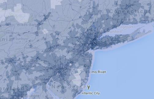
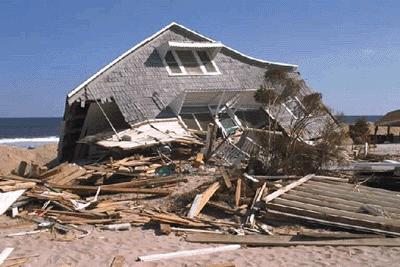
18 Hurricane Sandy - October 25,

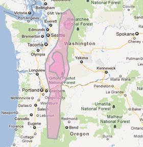
19 Mills Canyon Fire- July 12,

20 Recent Flooding 20

21 Recent Flooding 21
22 22
23 23

24 24

25 25
26 Live Demo & Geography Discussion 26
27 ACS Data Basics Retrieve characteristics about an area Measure socioeconomic change Based on a small sample of households each month Replace detailed information from decennial long form (income, education, employment status, disability, etc.) 27
28 ACS Geography Larger geographies - think county vs block, more people (in theory), more samples, lower margin of error (MOE) Smaller geographies typically have larger MOEs Small events interact with small geographies 28
29 EM Geography For LODES or Decennial datasets, all blocks in an area can be aggregated because there is no MOE ACS data can be more complicated because better estimates come from larger areas EM aggregates these together automatically 29
30 Checking Geography and Data Use OnTheMap (onthemap.ces.census.gov) to examine the underlying geography of an event Understanding what s happening allows for better use of the data 30

31 31

32 32
33 Thank You! Tool URL: Feedback: 33
Crossing Boundaries Building Tools to Combine Public-Use (and Misaligned) Data
 Data") Crossing Boundaries Building Tools to Combine Public-Use (and Misaligned) Data Matthew Graham LEHD Program Center for Economic Studies U.S. Census Bureau 2018 FCSM Research and Policy Conference 1 Disclaimer
Crossing Boundaries Building Tools to Combine Public-Use (and Misaligned) Data Matthew Graham LEHD Program Center for Economic Studies U.S. Census Bureau 2018 FCSM Research and Policy Conference 1 Disclaimer
Monday, November 26, :30 a.m. EST
 Monday, November 26, 2018 8:30 a.m. EST Significant Activity Nov 23-26 Significant Events: CA Wildfires Tropical Activity: Atlantic No new tropical cyclones are expected during the next 5 days Eastern
Geospatial Analysis of Job-Housing Mismatch Using ArcGIS and Python
 Geospatial Analysis of Job-Housing Mismatch Using ArcGIS and Python 2016 ESRI User Conference June 29, 2016 San Diego, CA Jung Seo, Frank Wen, Simon Choi and Tom Vo, Research & Analysis Southern California
Red Hook Recovery Project. Hurricane Sandy An Urban Disaster
 Red Hook Recovery Project Hurricane Sandy An Urban Disaster Overview Impact of Changing weather Urban Preparedness Overview of preparedness efforts Complexities of urban planning (Ex. NYC) Understanding
Orien Ori t en a t tion a Webi W nar: ebi CPD Maps 2
 Orientation Webinar: CPD Maps 2 Agenda 1. Background - econ Planning Suite 2. Expanded Planning Data 3. CPD Maps Overview 4. Demonstration Guide Me Wizard Map Selection Identify Tool Printing and Saving
Spatiotemporal Analysis of Commuting Patterns in Southern California Using ACS PUMS, CTPP and LODES
 Spatiotemporal Analysis of Commuting Patterns in Southern California Using ACS PUMS, CTPP and LODES 2017 ACS Data Users Conference May 11-12, 2017 Alexandria, VA Jung Seo, Tom Vo, Frank Wen and Simon Choi
Spatial and Socioeconomic Analysis of Commuting Patterns in Southern California Using LODES, CTPP, and ACS PUMS
 Spatial and Socioeconomic Analysis of Commuting Patterns in Southern California Using LODES, CTPP, and ACS PUMS Census for Transportation Planning Subcommittee meeting TRB 95th Annual Meeting January 11,
B.2 Sources for Hazard Identification, Profiling, and Ranking (Section 3) Overview of Sussex County s History of Hazards
 Overview of Sussex County s History of Hazards") Appendix B Sources B.1 Sources for Planning Process (Section 2) FEMA. Mitigation Planning Guidance (386 Series). Available on the web at: http://www.fema.gov/plan/mitplanning/planning_resources.shtm FEMA
Appendix B Sources B.1 Sources for Planning Process (Section 2) FEMA. Mitigation Planning Guidance (386 Series). Available on the web at: http://www.fema.gov/plan/mitplanning/planning_resources.shtm FEMA
Spatiotemporal Analysis of Commuting Patterns: Using ArcGIS and Big Data
 Spatiotemporal Analysis of Commuting Patterns: Using ArcGIS and Big Data 2017 ESRI User Conference July 13, 2017 San Diego, VA Jung Seo, Tom Vo, Frank Wen and Simon Choi Research & Analysis Southern California
Sunday, November 25, :30 a.m. EST
 Sunday, November 25, 2018 8:30 a.m. EST Significant Activity Nov 24-25 Significant Events: CA Wildfires Tropical Activity: Atlantic Disturbance 1: Low (near 0%) Eastern Pacific Disturbance 1: Low (near
Social Vulnerability Index. Susan L. Cutter Department of Geography, University of South Carolina
 Social Vulnerability Index Susan L. Cutter Department of Geography, University of South Carolina scutter@sc.edu Great Lakes and St. Lawrence Cities Initiative Webinar December 3, 2014 Vulnerability The
Demographic Data in ArcGIS. Harry J. Moore IV
 Demographic Data in ArcGIS Harry J. Moore IV Outline What is demographic data? Esri Demographic data - Real world examples with GIS - Redistricting - Emergency Preparedness - Economic Development Next
Baldwin County, Alabama
 2015 Baldwin County, Alabama Multi-Hazard Mitigation Plan I. Comprehensive Plan A multi-jurisdiction plan City of Bay Minette City of Daphne Town of Elberta City of Fairhope City of Foley City of Gulf
The Church Demographic Specialists
 The Church Demographic Specialists Easy-to-Use Features Map-driven, Web-based Software An Integrated Suite of Information and Query Tools Providing An Insightful Window into the Communities You Serve Key
A GEOGRAPHIC ASSESSMENT OF MAJOR DISASTER DECLARATIONS ACROSS THE LOWER 48 STATES
 A GEOGRAPHIC ASSESSMENT OF MAJOR DISASTER DECLARATIONS ACROSS THE LOWER 48 STATES A summary report produced by the Southern Climate Impacts Planning Program (SCIPP) Author: James Hocker Southern Climate
KENTUCKY HAZARD MITIGATION PLAN RISK ASSESSMENT
 KENTUCKY HAZARD MITIGATION PLAN RISK ASSESSMENT Presentation Outline Development of the 2013 State Hazard Mitigation Plan Risk Assessment Determining risk assessment scale Census Data Aggregation Levels
Reducing Vulnerability to Extreme Heat: Science-Policy Interface
 Reducing Vulnerability to Extreme Heat: Science-Policy Interface Olga Wilhelmi, Mary Hayden, Jennifer Boehnert, Ursula Lauper and SIMMER research team October 23, 2013 Toronto SIMMER workshop Science-Policy
Saturday, November 17, :30 a.m. EST
 Saturday, November 17, 2018 8:30 a.m. EST Significant Activity Nov 16-17 Significant Events: CA Wildfires Tropical Activity: Atlantic No new tropical cyclones are expected during the next 5 days Eastern
Visualization of Commuter Flow Using CTPP Data and GIS
 Visualization of Commuter Flow Using CTPP Data and GIS Research & Analysis Department Southern California Association of Governments 2015 ESRI User Conference l July 23, 2015 l San Diego, CA Jung Seo,
Wednesday, November 28, :30 a.m. EST
 Wednesday, November 28, 2018 8:30 a.m. EST Significant Activity Nov 27-28 Significant Events: None Tropical Activity: Atlantic No new tropical cyclones are expected during the next 5 days Eastern Pacific
Saturday, April 14, :30 a.m. EDT
 Saturday, April 14, 2018 8:30 a.m. EDT Significant Activity April 13-14 Significant Events: Severe Weather Southern/Central Plains and Lower/Middle Mississippi Valley Tropical Activity: Western Pacific
Assessing Social Vulnerability to Biophysical Hazards. Dr. Jasmine Waddell
 Assessing Social Vulnerability to Biophysical Hazards Dr. Jasmine Waddell About the Project Built on a need to understand: The pre-disposition of the populations in the SE to adverse impacts from disaster
Thursday, March 7, :30 a.m. EST
 Thursday, March 7, 2019 8:30 a.m. EST Significant Activity Mar 6-7 Significant Events: Severe thunderstorms and tornadoes AL and GA (FINAL) Tropical Activity: No activity affecting U.S. interests Significant
Daily Operations Briefing. Tuesday, January 9, :30 a.m. EST
 Daily Operations Briefing Tuesday, January 9, 2018 8:30 a.m. EST Significant Activity Jan 8-9 Significant Events: Flash Flooding CA Tropical Activity: None Significant Weather: Heavy rain and Thunderstorms
4.1 Hazard Identification: Natural Hazards
 data is provided in an annex, it should be assumed that the risk and potential impacts to the affected jurisdiction are similar to those described here for the entire Sacramento County Planning Area. This
Demographic Data. How to get it and how to use it (with caution) By Amber Keller
 By Amber Keller") Demographic Data How to get it and how to use it (with caution) By Amber Keller 101 Where does it come from? o The American Community Survey o Socio-economic characteristics of a population o Administered
Demographic Data How to get it and how to use it (with caution) By Amber Keller 101 Where does it come from? o The American Community Survey o Socio-economic characteristics of a population o Administered
Tuesday, March 5, :30 a.m. EST
 Tuesday, March 5, 2019 8:30 a.m. EST Significant Activity Mar 4-5 Significant Events: Severe thunderstorms and tornadoes AL and GA Tropical Activity: No activity affecting U.S. interests Significant Weather:
Daily Operations Briefing. Saturday, March 17, :30 a.m. EDT
 Daily Operations Briefing Saturday, March 17, 2018 8:30 a.m. EDT Significant Activity Mar 16-17 Significant Events: None Tropical Activity: Western Pacific No activity affecting U.S. interests Significant
Monday, November 19, :30 a.m. EST
 Monday, November 19, 2018 8:30 a.m. EST Significant Activity Nov 16-19 Significant Events: CA Wildfires Tropical Activity: Atlantic No new tropical cyclones are expected during the next 5 days Eastern
IWT Scenario 2 Integrated Warning Team Workshop National Weather Service Albany, NY October 31, 2014
 IWT Scenario 2 Integrated Warning Team Workshop National Weather Service Albany, NY October 31, 2014 09 10 11 12 13 Scenario 2 Timeline December 9-13 Tue Wed Thu Fri Sat Tue, Dec. 9 @ 5 am 2014 2014 2014
Daily Operations Briefing Monday, March 13, :30 a.m. EDT
 Daily Operations Briefing Monday, March 13, 2017 8:30 a.m. EDT Significant Activity Mar 10-13 Significant Events: Nor easter Northeastern U.S. March 13-14 Significant Weather: Heavy snow possible Mid-Atlantic
RISK ASSESSMENT COMMUNITY PROFILE NATURAL HAZARDS COMMUNITY RISK PROFILES. Page 13 of 524
 RISK ASSESSMENT COMMUNITY PROFILE NATURAL HAZARDS COMMUNITY RISK PROFILES Page 13 of 524 Introduction The Risk Assessment identifies and characterizes Tillamook County s natural hazards and describes how
Poverty and Hazard Linkages
 Poverty and Hazard Linkages Global Risk Identification Programme Proposal Development Coordination Meeting Friday, 19 May 2006 CIESIN Earth Institute Columbia University www.ciesin.columbia.edu Data Improvements
Kentucky Weather Hazards: What is Your Risk?
 Kentucky Weather Hazards: What is Your Risk? Stuart A. Foster State Climatologist for Kentucky 2010 Kentucky Weather Conference Bowling Green, Kentucky January 16, 2010 Perspectives on Kentucky s Climate
Daily Operations Briefing
 Daily Operations Briefing Saturday, December 9, 2017 8:30 a.m. EST Significant Activity Dec 8-9 Significant Events: Wildfires - southern California Tropical Activity: Western Pacific No activity affecting
Sunday, December 2, :30 a.m. EST
 Sunday, December 2, 2018 8:30 a.m. EST Significant Activity Dec 1-2 Significant Events: Earthquake Alaska Tropical Activity: Western Pacific No activity affecting U.S. interests Significant Weather: Winter
Hurricane Readiness for Coastal Communities
 Hurricane Readiness for Participant Guide Developed for: Federal Emergency Management Agency Emergency Management Institute 16825 South Seton Avenue Emmitsburg, MD 21727-8998 Developed by: C² Technologies,
Module 10 Summative Assessment
 Module 10 Summative Assessment Activity In this activity you will use the three dimensions of vulnerability that you learned about in this module exposure, sensitivity, and adaptive capacity to assess
5.2 IDENTIFICATION OF HAZARDS OF CONCERN
 5.2 IDENTIFICATION OF HAZARDS OF CONCERN 2016 HMP Update Changes The 2011 HMP hazard identification was presented in Section 3. For the 2016 HMP update, the hazard identification is presented in subsection
NC Emergency Management A View from the Counties
 NC Emergency Management A View from the Counties Amy Bason, NCACC Rocky Hyder, Henderson County Jeff Batten, Durham County Norman Bryson, Onslow County PARTNERSHIP Emergency Management efforts require
5.2 IDENTIFICATION OF HAZARDS OF CONCERN
 5.2 IDENTIFICATION OF HAZARDS OF CONCERN 2015 HMP Update Changes The 2010 HMP hazard identification was presented in Section 6. For the 2015 HMP update, the hazard identification is presented in subsection
2014 Planning Database (PDB)
") 2014 Planning Database (PDB) November 19, 2014 Barbara O Hare, Nancy Bates, Julia Coombs, Travis Pape, Chandra Erdman Office of Survey Analytics 1 Overview Tract and Block Group PDBs Useful for: Identifying
2014 Planning Database (PDB) November 19, 2014 Barbara O Hare, Nancy Bates, Julia Coombs, Travis Pape, Chandra Erdman Office of Survey Analytics 1 Overview Tract and Block Group PDBs Useful for: Identifying
Wednesday, June 13, :30 a.m. EDT
 Wednesday, June 13, 2018 8:30 a.m. EDT Significant Activity June 12-13 Significant Events: None Tropical Activity: Atlantic Disturbance 1: Low (20%) Eastern Pacific Tropical Storm Bud; Disturbance 1: Low
Sunday, December 9, :30 a.m. EST
 Sunday, December 9, 2018 8:30 a.m. EST Significant Activity Dec 8-9 Significant Events: Winter Weather Southern U.S. Tropical Activity: Western Pacific No activity affecting U.S. interests Significant
Daily Operations Briefing Thursday, April 6, :30 a.m. EDT
 Daily Operations Briefing Thursday, April 6, 2017 8:30 a.m. EDT Significant Activity Apr 5-6 Significant Events: Severe Weather Southeast and Mid-Atlantic Significant Weather: Severe thunderstorms possible
5.2. IDENTIFICATION OF NATURAL HAZARDS OF CONCERN
 5.2. IDENTIFICATION OF NATURAL HAZARDS OF CONCERN To provide a strong foundation for mitigation strategies considered in Sections 6 and 9, County considered a full range of natural hazards that could impact
WINTER STORM Annex II
 WINTER STORM Annex II I. PURPOSE A. This annex has been prepared to ensure a coordinated response by state agencies to requests from local jurisdictions to reduce potential loss of life and to ensure essential
Jim Fox. copyright UNC Asheville's NEMAC
 Decisions and System Thinking Jim Fox November, 2012 1 UNC Asheville s s NEMAC National Environmental Modeling and Analysis Center Applied Research and technology development on integration of environmental
Wednesday, December 5, :30 a.m. EST
 Wednesday, December 5, 2018 8:30 a.m. EST Significant Activity Dec 4 5 Significant Events: None Tropical Activity: Western Pacific No activity affecting U.S. interests Significant Weather: Rain / Snow
Summary of Available Datasets that are Relevant to Flood Risk Characterization
 Inter-Agency Characterization Workshop February 25-27, 2014 USACE Institute for Water Resources, Alexandria, VA, IWR Classroom Summary of Available Datasets that are Relevant to Characterization National
Daily Operations Briefing Monday, February 13, :30 a.m. EST
 Daily Operations Briefing Monday, February 13, 2017 8:30 a.m. EST Significant Activity Feb 10-13 Significant Events: Oroville Dam Spillway Erosion CA Significant Weather: Heavy Snow Southwest to Southern
Friday, April 13, :30 a.m. EDT
 Friday, April 13, 2018 8:30 a.m. EDT Significant Activity April 12-13 Significant Events: Severe Weather Middle and Lower Mississippi Valley 34 Complex Fire Tropical Activity: Western Pacific No activity
Timeframe. Crow Wing County, Baxter, Brainerd, Breezy Point, Crosby, Crosslake, Cuyuna, Deerwood, Emily, Fifty
 Table G - 13. s Identified for by the () (From Crow Wing County Master Chart) 1 5 9 All- Hazards All- Hazards Winter Work to ensure that all Crow Wing County residents are aware of and sign-up for the
Bossier Parish Hazard Mitigation Plan Update Public Meeting. August 10, 2016 Bossier City, LA
 Bossier Parish Hazard Mitigation Plan Update Public Meeting August 10, 2016 Bossier City, LA Agenda Hazard Mitigation Planning Process SDMI Staff Risk Assessment SDMI Staff Update on Previous/Current Mitigation
Daily Operations Briefing Saturday, March 11, :30 a.m. EST
 Daily Operations Briefing Saturday, March 11, 2017 8:30 a.m. EST Significant Activity Mar 10-11 Significant Events: Daylight Saving Time Significant Weather: Freezing Rain possible Lower Mississippi and
Daily Operations Briefing. Saturday, May 13, :30 a.m. EDT
 Daily Operations Briefing Saturday, May 13, 2017 8:30 a.m. EDT Significant Activity May 12-13 Significant Events: None Significant Weather: Flash Flooding possible Northern NJ and New York City Fire Weather:
Understanding China Census Data with GIS By Shuming Bao and Susan Haynie China Data Center, University of Michigan
 Understanding China Census Data with GIS By Shuming Bao and Susan Haynie China Data Center, University of Michigan The Census data for China provides comprehensive demographic and business information
THE USAGE OF GIS APPLICATIONS IN SURVEYS DEPARTMENT. Tools for planning and managing the work of interviewers
 THE USAGE OF GIS APPLICATIONS IN SURVEYS DEPARTMENT Tools for planning and managing the work of interviewers In the Surveys Department, we use the GIS tool for field work. For example: visualization of
Daily Operations Briefing. Wednesday, December 20, :30 a.m. EST
 Daily Operations Briefing Wednesday, December 20, 2017 8:30 a.m. EST Significant Activity Dec 19-20 Significant Events: Wildfires southern California Tropical Activity: Western Pacific No activity affecting
Multi-Jurisdictional Hazard Mitigation Plan. Table C.17 Disaster Declarations or Proclamations Affecting Perry County Presidential & Gubernatorial
 Severe Weather General Severe weather affects the entire Commonwealth and can be expected any time of the year. Severe weather for Perry County is considered to include: blizzards and/or heavy snowfall,
The Wind Hazard: Messaging the Wind Threat & Corresponding Potential Impacts
 The Wind Hazard: Messaging the Wind Threat & Corresponding Potential Impacts Scott Spratt Warning Coordination Meteorologist NWS Melbourne, FL David Sharp Science & Operations Officer NWS Melbourne, FL
Daily Operations Briefing. Monday, April 2, :30 a.m. EDT
 Daily Operations Briefing Monday, April 2, 2018 8:30 a.m. EDT Significant Activity Mar 31-April 2 Significant Events: None Tropical Activity: No significant activity Significant Weather: Heavy Snow Northern
The Delaware Environmental Observing System
 The Delaware Environmental Observing System DECISION SUPPORT FOR COASTAL FLOODING AND SNOWFALL Daniel Leathers, State Climatologist, Professor University of Delaware Tina Callahan, DEMAC, University of
Daily Operations Briefing Tuesday, April 4, :30 a.m. EDT
 Daily Operations Briefing Tuesday, April 4, 2017 8:30 a.m. EDT Significant Activity Apr 3-4 Significant Events: Severe Weather Southern Plains to Southeast Significant Weather: Severe Thunderstorms and
West Carroll Parish Hazard Mitigation Plan Update Public Meeting. August 25, 2015 Oak Grove, LA
 West Carroll Parish Hazard Mitigation Plan Update Public Meeting August 25, 2015 Oak Grove, LA Agenda Hazard Mitigation Planning Process SDMI Staff Risk Assessment SDMI Staff Update on Previous/Current
Daily Operations Briefing Friday, March 10, :30 a.m. EST
 Daily Operations Briefing Friday, March 10, 2017 8:30 a.m. EST Significant Activity Mar 9-10 Significant Events: None Significant Weather: Freezing rain possible Northern/Central Plains and Middle Mississippi
COMMUNITY SERVICE AREA
 INSTITUTE FOR TRIBAL ENVIRONMENTAL PROFESSIONALS Tribal Waste and Response Assistance Program (TWRAP) Developing and Implementing a Tribal Integrated Solid Waste Management Plan April 12-14, 2016 Palm
Wednesday, May 30, :30 a.m. EDT
 Wednesday, May 30, 2018 8:30 a.m. EDT Significant Activity May 29-30 Significant Events: Remnants of Tropical Depression Alberto Tropical Activity: Western Pacific No activity affecting U.S. interests
Page G Crow Wing County Multi-Hazard Mitigation Plan, 2017
 Table G - 10. s Identified by the () (From Crow Wing County Master Chart) 1 5 All- Hazards All- Hazards Work to ensure that all Crow Wing County residents are aware of and sign-up for the County s Emergency
Saturday, June 9, :30 a.m. EDT
 Saturday, June 9, 2018 8:30 a.m. EDT Significant Activity June 8-9 Significant Events: None Tropical Activity: Atlantic No tropical cyclones expected next 48 hours Eastern Pacific Hurricane Aletta; Disturbance
IDENTIFICATION OF HAZARDS OF CONCERN
 IDENTIFICATION OF HAZARDS OF CONCERN To provide a strong foundation for mitigation strategies considered in Section 6, the Village considered a full range of hazards that could impact the area and then
Daily Operations Briefing. Tuesday, December 5, :30 a.m. EST
 Daily Operations Briefing Tuesday, December 5, 2017 8:30 a.m. EST Thomas Fire CA Fire Name (County) Thomas (Ventura) FMAG # / Approved 5224-FM-CA Dec 5,2017 Acres burned Percent Contained Current Situation
Daily Operations Briefing. Tuesday, March 13, :30 a.m. EDT
 Daily Operations Briefing Tuesday, March 13, 2018 8:30 a.m. EDT Nor easter March 12 & continuing Current Situation A third coastal storm in two weeks will deliver heavy wet snow, gusty winds, and minor
The Tampa Bay Catastrophic Plan Presentation to CFGIS Users Group FDOT District 5 Urban Offices - Orlando July 30, 2010
 The Tampa Bay Catastrophic Plan Presentation to CFGIS Users Group FDOT District 5 Urban Offices - Orlando July 30, 2010 Brady Smith Senior Planner Tampa Bay Regional Planning Council Introduction Recent
Daily Operations Briefing Tuesday, March 28, :30 a.m. EDT
 Daily Operations Briefing Tuesday, March 28, 2017 8:30 a.m. EDT Significant Activity Mar 27-28 Significant Events: None Significant Weather: Severe Thunderstorms TX & OK Flash Flooding TX & OK Freezing
Daily Operations Briefing Wednesday, February 8, :30 a.m. EST
 Daily Operations Briefing Wednesday, February 8, 2017 8:30 a.m. EST Significant Activity Feb 7-8 Significant Events: Severe weather/tornadoes - Louisiana Significant Weather: Freezing rain possible Pacific
On Page 1, following Paragraph 2 of the Planning Participants subsection, insert the following: 2012 Committee members included:
 Appendix 4: City of West Linn Addendum to the Clackamas County Natural Hazards Mitigation Plan 2012 Amendments and Update The Oregon Partnership for Disaster Resilience prepared this Appendix to the City
CITY OF TUSCALOOSA ORGANIZATION OF 2015 FMP FLOODPLAIN MANAGEMENT PLAN
 CITY OF TUSCALOOSA FLOODPLAIN MANAGEMENT PLAN FMPC Meeting #2 July 8, 2015 ORGANIZATION OF 2015 FMP 2015 Floodplain Management Plan Structure Chapter 1 Introduction Chapter 2 Community Profile Chapter
Daily Operations Briefing Thursday, March 9, :30 a.m. EST
 Daily Operations Briefing Thursday, March 9, 2017 8:30 a.m. EST Significant Activity Mar 8-9 Significant Events: None Significant Weather: Severe thunderstorms possible Central Plains to Middle/Lower Mississippi
Visualization of Origin- Destination Commuter Flow Using CTPP Data and ArcGIS
 Visualization of Origin- Destination Commuter Flow Using CTPP Data and ArcGIS Research & Analysis Department Southern California Association of Governments 2015 ESRI User Conference l July 23, 2015 l San
Oregon APA Legal Issues Workshop December 7, Tricia Sears, DLCD With information from Bill Burns, DOGAMI
 Oregon APA Legal Issues Workshop December 7, 2018 Tricia Sears, DLCD With information from Bill Burns, DOGAMI How this Topic Arrived WE FREQUENTLY HEAR CONCERNS ABOUT LIABILITY AND TAKINGS. Current federal
GIS DISASTER MAPPING TO UPDATE WARNING SYSTEMS
 POSTER SESSIONS 309 GIS DISASTER MAPPING TO UPDATE WARNING SYSTEMS UTEJ. DYMON DEPT. OF GEOGRAPHY KENT STATE UNIVERSITY KENT, OHIO 44242-0001, USA DYMON@HUMBOLDT.KENT.EDU FAX (216) 672-4304 ABSTRACT The
Population Research Center (PRC) Oregon Population Forecast Program
 Oregon Population Forecast Program") Population Research Center (PRC) Oregon Population Forecast Program 2013 Oregon League of Cities Conference Risa S. Proehl Jason R. Jurjevich, Ph.D. Population Research Center (PRC) Population Research
Population Research Center (PRC) Oregon Population Forecast Program 2013 Oregon League of Cities Conference Risa S. Proehl Jason R. Jurjevich, Ph.D. Population Research Center (PRC) Population Research
Massachusetts Hurricane Evacuation Study
 Massachusetts Hurricane Evacuation Study Technical Data Report May 2016 New England District Massachusetts Hurricane Evacuation Study Technical Data Report May 2016 Table of Contents 1.0 Study Area...
Table G - 6. Mitigation Actions Identified for Implementation by the City of Kent ( ) (From Wilkin County Master Mitigation Action Chart)
 (From Wilkin County Master Mitigation Action Chart)") Table G - 6. Actions Identified by the () (From Master Action Chart) Multi-Hazard Plan, 2017 Action Comments 5 All-Hazards Local Planning & Regulations Update the Operations Plan on an annual basis. Work
Table G - 6. Actions Identified by the () (From Master Action Chart) Multi-Hazard Plan, 2017 Action Comments 5 All-Hazards Local Planning & Regulations Update the Operations Plan on an annual basis. Work
MAKING PLANNING LOCAL
 Georgia Social Vulnerability Index 2010 Atlas MAKING PLANNING LOCAL VULNERABLE & AT-RISK POPULATIONS DATA FOR JURISDICTIONS AT THE CENSUS TRACT LEVEL Public Health Districts Regional Coordinating Hospital
Geography and Usability of the American Community Survey. Seth Spielman Assistant Professor of Geography University of Colorado
 Geography and Usability of the American Community Survey Seth Spielman Assistant Professor of Geography University of Colorado Goals 1. To convince you that the margins of error from the American Community
Use of US Census Data for Transportation Modeling and Planning
 Use of US Census Data for Transportation Modeling and Planning Yongqiang Wu, P.E. CTS Engineering, Inc. Southeast Florida FSUTMS User Group Meeting September 14, 2018 Outline Overview of Census Products
FHWA Planning Data Resources: Census Data Planning Products (CTPP) HEPGIS Interactive Mapping Portal
 HEPGIS Interactive Mapping Portal") FHWA Planning Data Resources: Census Data Planning Products (CTPP) HEPGIS Interactive Mapping Portal Jeremy Raw, P.E. FHWA, Office of Planning, Systems Planning and Analysis August 2017 Outline Census
FHWA Planning Data Resources: Census Data Planning Products (CTPP) HEPGIS Interactive Mapping Portal Jeremy Raw, P.E. FHWA, Office of Planning, Systems Planning and Analysis August 2017 Outline Census
Understanding and accessing 2011 census aggregate data
 Understanding and accessing 2011 census aggregate data 4 July 11:00 to 16:00 BST Justin Hayes and Richard Wiseman UK Data Service Census Support UK censuses provide an unparalleled resource of high quality
Business Preparedness and Hurricane Risk
 Business Preparedness and Hurricane Risk Hurricanes are one of the more predictable natural disasters compared to events such as earthquakes, wildfires and tornadoes. Meteorologists gather data to predict
Table-Top Exercise for Emergency Preparedness Evaluation: Little Anse, Isle Madame
 Table-Top Exercise for Emergency Preparedness Evaluation: Little Anse, Isle Madame Alexander Chung, M.Sc. Candidate C-Change Student Research Associate May 2013 The Community of Little Anse Coastal community
Daily Operations Briefing Tuesday, November 1, :30 a.m. EDT
 Daily Operations Briefing Tuesday, November 1, 2016 8:30 a.m. EDT Significant Activity Oct 31-Nov 1 Significant Events: None Tropical Activity: Atlantic No tropical cyclone activity expected for the next
A HURRICANE IS COMING. Presented by Atiba Upchurch Broward Emergency Management Division
 A HURRICANE IS COMING Presented by Atiba Upchurch Broward Emergency Management Division Mission Statement To safeguard the lives and property of the people of Broward County from major hazards and emergencies
Quick Response Report. Mobile Home Resident Preparedness and Response to Tornado Warnings: The 27 April 2011 Disaster in DeKalb, County, Alabama
 Quick Response Report Mobile Home Resident Preparedness and Response to Tornado Warnings: The 27 April 2011 Disaster in DeKalb, County, Alabama Philip L. Chaney 1 Greg S. Weaver 2 Susan Youngblood 3 Kristin
Global Atmospheric Circulation. Past climate change and natural causes. Global climate change and human activity
 GCSE Geography Edexcel B Revision Checklist Paper 1. Global Geographical Issues Topic 1. Hazardous Earth Key Idea I know/ understand The world s climate system Global Atmospheric Circulation Past climate
United States Multi-Hazard Early Warning System
 United States Multi-Hazard Early Warning System Saving Lives Through Partnership Lynn Maximuk National Weather Service Director, Central Region Kansas City, Missouri America s s Weather Enterprise: Protecting
Hurricane Preparation and Recovery. October 11, 2011 Jon Nance, Chief Engineer, NCDOT
 Hurricane Preparation and Recovery October 11, 2011 Jon Nance, Chief Engineer, NCDOT North Carolina & Severe Weather Our state often bears the brunt of storms, which include: Ice storms Snow storms Heavy
Daily Operations Briefing. Tuesday, March 27, :30 a.m. EDT
 Daily Operations Briefing Tuesday, March 27, 2018 8:30 a.m. EDT Significant Activity Mar 26-27 Significant Events: None Tropical Activity: Western Pacific No activity affecting U.S. interests Significant
Sunday, June 3, :30 a.m. EDT
 Sunday, June 3, 2018 8:30 a.m. EDT Significant Activity June 2-3 Significant Events: None Tropical Activity: Atlantic No tropical cyclones expected next 48 hours Eastern Pacific Disturbance 1: HIGH (90%)