Presentation Plus! Glencoe World Geography Copyright by The McGraw-Hill Companies, Inc. Developed by FSCreations, Inc., Cincinnati, Ohio 45202
|
|
|
- Gavin McKinney
- 6 years ago
- Views:
Transcription
1 Presentation Plus! Glencoe World Geography Copyright by The McGraw-Hill Companies, Inc. Developed by FSCreations, Inc., Cincinnati, Ohio Send all inquiries to: GLENCOE DIVISION Glencoe/McGraw-Hill 8787 Orion Place Columbus, Ohio 43240
2 Coach Shipman s Class Rules Do not speak while the teacher is talking or if another student has the floor. Be professional. Absolutely no profanity or inappropriate language. Students will enter class and be seated. Don t stand at the door or lounge around the classroom. Once you are inside sit at your desk. Students are not dismissed until I say so. Make sure you are in your assigned seat. Follow ALL school rules. Just Do Right!
3 Definition of PROFESSIONALISM 1 : the conduct, aims, or qualities that characterize or mark aprofession or a professional person(see 1 PROFESSIONAL) 2 : the following of a profession (as athletics) for gain or livelihood See professionalism defined for Englishlanguage learners»
4
5 Chapter Introduction Section 1 The Land Section 2 Climate and Vegetation Chapter Summary & Study Guide Chapter Assessment Click on a hyperlink to view the corresponding slides.
6
7 Chapter Objectives Identify East Asia s varied landforms, water systems, and natural resources. Explain the factors that influence East Asia s diverse climates and vegetation. Space Bar to display the information.

8 As you read this chapter, use your journal to note the landforms and climate regions of East Asia. Write a series of descriptive paragraphs about these geographic features. Be sure to create a vivid, detailed description of each feature.
9
10 The Land Objectives Describe how East Asia s landforms are affected by the region s location on the Ring of Fire. Compare the landforms of China with those in the rest of East Asia. List the important natural resources that are present in East Asia. Space Bar to display the information.
11 The Land Terms to Know archipelago tsunami loess Space Bar to display the information.
12 The Land Places to Locate Mongolia Hong Kong Macau South China Sea Korean Peninsula Japan Pamirs Himalaya Plateau of Tibet (Plateau of Xizang) Space Bar to display the information. Tarim Basin Taklimakan Desert Gobi Yellow River (Huang He) Yangtze River (Chang Jiang) Xi (West) River

13 Click the Speaker button to listen to the audio again.

14 Japan is a chain of more than 3,000 islands running from Hokkaido in the north to the distant Ryukyu Islands in the south. Four main islands Honshu, Hokkaido, Shikoku, and Kyushu account for more than 98 percent of the total land area. At their greatest length from the northeast to southwest, the main islands stretch about 1,200 mi (1,900 km) and span 900 miles (1,500 km) from east to west. Japan has over 18,000 miles of coastline, but its total size is less than that of California.
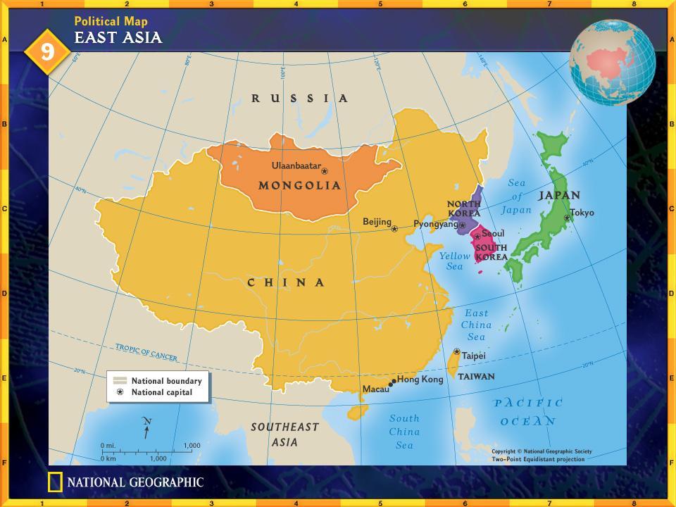
15 Land and Sea China covers about 80 percent of East Asia s land area and has the world s largest population more than 1.25 billion people. The rest of East Asia is shared by Japan, Taiwan, North and South Korea, and Mongolia. Space Bar to display the information. (pages )
16 Land and Sea (cont.) Peninsulas, Islands, and Seas Along the coast of East Asia, many peninsulas and islands dot the westernmost Pacific Ocean. The South China Sea, stretching from Taiwan to the Philippines and the peninsula of Southeast Asia, carries one-third of the world s shipping traffic. Space Bar to display the information. (pages )
17 Land and Sea (cont.) The Ring of Fire The islands of Japan and Taiwan are part of the Pacific Ring of Fire, a circle of volcanoes bordering the Pacific Ocean. Plate movements there cause frequent, violent earthquakes and volcanic eruptions. Japan has more than a thousand minor earthquakes every year. Space Bar to display the information. (pages )
18 Land and Sea (cont.) Japan is also vulnerable to tsunamis generated by underwater earthquakes. These high tidal waves crash over the land and can cause great destruction and loss of life. Space Bar to display the information. (pages )
 Click the Speaker")

19 Land and Sea (cont.) Click the Speaker button to listen to the audio again. (pages )
20 Land and Sea (cont.) Given its location on the Ring of Fire, why does Japan have such a large population? Japan is a highly developed country that has learned to adapt to the environment. Space Bar to display the answer. (pages )
21 Mountains, Highlands, and Lowlands Mountain ranges and highlands mark inland regions of East Asia. Lowlands stretch through eastern and coastal areas. (pages )
22 Mountains, Highlands, and Lowlands (cont.) East Asian Mountains - From an area of high peaks known as the Pamirs, the Kunlun Shan and Tian Shan ranges extend across western China. - The Himalaya, the world s highest mountains, separate China from South Asia. - Japan and Taiwan have mountainous interiors surrounded by coastal plains. - Mount Fuji is a dramatic peak rising above the central plains of Honshu, Japan s biggest island. Space Bar to display the information. (pages )
23 Mountains, Highlands, and Lowlands (cont.) China s Plateaus, Basins, and Deserts - The Plateau of Tibet in southwest China is East Asia s highest plateau region with an elevation of about 15,000 feet (4,600 m). - The Mongolian Plateau consists mainly of grassy pastures ideal for grazing. - Broad, flat highlands include the Tarim Basin between China s far inland mountain ranges; the Taklimakan Desert to its west; and the Gobi, a desert area located in the north. Space Bar to display the information. (pages )
24 Mountains, Highlands, and Lowlands (cont.) - The Sichuan Basin, a huge, fertile area between the Plateau of Tibet and the North China Plain, is one of China s most important agricultural areas. - It has a mild climate and a long growing season. Space Bar to display the information. (pages )
25 Mountains, Highlands, and Lowlands (cont.) Where do most people in the region live? Why? The Sichuan Basin has a large population because it is fertile farmland. Space Bar to display the answer. (pages )
26 River Systems China s Rivers - China s major rivers originate high in the Plateau of Tibet and flow eastward to the Pacific Ocean. - The Yellow River, or Huang He, gets its name from the tons of yellowish topsoil blown by winds from the western deserts. - Carried eastward and deposited by the river, this rich soil makes the North China Plain an agriculturally productive area. - Throughout history, flood waters have also killed hundreds of thousands of people. Space Bar to display the information. (pages )
 Click the Speaker")

27 River Systems (cont.) Click the Speaker button to listen to the audio again. (pages )
28 River Systems (cont.) - Central China s Yangtze, or Chang Jiang, is Asia s longest river at 3,965 miles (6,380 km). - It flows through gorges and plains and empties into the ocean at Shanghai. - The Xi, or West, River is southern China s most important river. - It flows into the South China Sea, where it has created a huge, fertile delta. - The Grand Canal the world s longest artificial waterway connects Hangzhou in the south to Beijing in the north. Space Bar to display the information. (pages )
29 River Systems (cont.) Rivers in Japan and Korea Japan and Korea have short, swiftly flowing rivers with spectacular waterfalls. These rivers provide hydroelectric power. North Korea s Amnok, or Yalu, River forms its border with China. Space Bar to display the information. (pages )
30 River Systems (cont.) The Power of Wind and Water The Chinese concept of feng shui guides architects, contractors, and decorators to design and build structures that harmonize with surrounding landforms. (pages )
31 River Systems (cont.) Why do the Chinese apply feng shui to architecture? Possible answer: When buildings fit harmoniously with their settings, the structures are more conductive to human activities, and the occupants gain peace of mind. Space Bar to display the answer. (pages )
32 Natural Resources China s large land area contains the greatest share and widest range of mineral resources, including iron ore, tungsten, tin, and gold. The Taklimakan Desert has large oil deposits. Northeastern China and the Korean peninsula have an abundance of coal. Only 10 percent of China s land is suitable for farming, but China is nonetheless the world s leading producer of rice. Space Bar to display the information. (pages )
33 Natural Resources (cont.) South Korea s prime farmland produces two crops a year of rice and barley. Mongolia and Japan have very limited farmland and poor soil. In Taiwan, about one-fourth of the land is farmable. Taiwan s most important resources are its hardwood forests. Space Bar to display the information. (pages )
34 Natural Resources (cont.) Japan, South Korea, Taiwan, and coastal China support the world s busiest deepsea fishing industries. Seafood farming also has become a major industry in East Asia. Space Bar to display the information. (pages )
 Click the Speaker button to listen to the")
35 Natural Resources (cont.) Click the Speaker button to listen to the audio again. (pages )
36 Natural Resources (cont.) Given Japan s limited space and poor soil, how have the Japanese been able to survive? Possible answer: They have made efficient use of limited farmland to grow food. They have depended on the sea for foods such as fish and seaweed. Space Bar to display the answer. (pages )
37 Checking for Understanding Define Match each definition in the left column with the appropriate term in the right column. A 1. a group or chain of islands C 2. fine, yellowish-brown topsoil made up of particles of silt and clay, usually carried by the wind B 3. Japanese term used for a huge sea wave caused by an undersea earthquake A. archipelago B. tsunami C. loess Space Bar to display the answers.
38 Critical Thinking Comparing and Contrasting How are East Asia s coastal, island, and peninsula areas similar? How do they differ from inland areas? The areas are similar in that they are close to the sea. The are different in that there are no long rivers and less farmland on islands. Space Bar to display the answer.
39 Critical Thinking Drawing Conclusions How does the technique of feng shui reflect East Asian beliefs about humans and their environment? Humans are a part of their environment and should be in harmony with it. Space Bar to display the answer.
40 Critical Thinking Predicting Consequences What consequences do you think will result from East Asia s use of its ocean resources? Possible answer: Current practices will result in overfishing or depletion of ocean resources. Space Bar to display the answer.
41 Analyzing Maps Place Study the physical-political map below. How does the elevation of the North China Plain compare with that of the Plateau of Tibet? Space Bar to display the answer.
42 Analyzing Maps The North China Plain, at feet (0-300m) above sea level, is at a much lower elevation than the Plateau of Tibet. This feature is located at 10,000 feet (3,000m) above sea level.
43 Applying Geography Soil Building Describe the soil-building process that takes place in northern China s Yellow River basin. How does this process influence the natural environment, the people, and economy of the area?
44 Close Reread A Geographic View on page 645 of your textbook. Write a description of an East Asian land or water feature that intrigues you, as if you were seeing it in person for the first time.
45
46 Climate and Vegetation Objectives State the reasons for East Asia s wide variety of climates. Explain how winds, ocean currents, and mountains influence the climates of East Asia. Identify the conditions that cause the extreme climates in much of China. List the kinds of natural vegetation that are found in East Asia s varied climate regions. Space Bar to display the information.
47 Climate and Vegetation Terms to Know monsoon Japan Current typhoon Space Bar to display the information.
48 Climate and Vegetation Places to Locate Taiwan Hainan Qin Ling Mountains Space Bar to display the information.

49 Click the Speaker button to listen to the audio again.
50 Mongolia is surrounded by land on all sides. It borders Russia to the north and China to the east, south, and west. About 80 percent of Mongolia s land consists of pastures and meadows. As a result, most Mongolians are engaged in agriculture, primarily as herders. Mongolians grow some wheat and barley, but the mainstay of the economy is raising livestock.
51 Climate Regions Dry highlands and grasslands dominate East Asia s north and west, with humid and temperate forests to the south and east. Mid-Latitude Climates - The southeastern quarter of East Asia has a humid subtropical climate. - Summers are warm, and rains are heavy. - The northeastern quarter has a humid continental climate, with cold, snowy winters. (pages )
52 Climate Regions (cont.) - In the eastern half of the region, forests consist of evergreen and deciduous trees. - Bamboo grows abundantly in warmer areas and is the only food source for rare mammals, such as giant and red pandas. - People in the region use bamboo in numerous ways, from medicines to material for bridges. - Tea and mulberry leaves also play a major role in the culture and economy of East Asia. Space Bar to display the information. (pages )
53 Climate Regions (cont.) Desert and Steppe Climates Mongolia and inland northern China are very dry because the surrounding mountains block the rain. Gobi and Taklimakan desert areas are often cold and windy. Temperatures in this climate region vary greatly. Space Bar to display the information. (pages )
54 Climate Regions (cont.) Highlands Climates The higher the elevation in the mountains, the colder the temperature. The Plateau of Tibet has an average high temperature of only 58ºF (14ºC). Tropical Rain Forest Climate Hainan, an island off of China s southern coast, shares a rain forest climate with Taiwan. The temperatures are always warm, and the summer is very rainy. Space Bar to display the information. (pages )
55 Climate Regions (cont.) The Roots of Rice and Soy The Chinese have cultivated rice and soybeans for seven thousand years. These are two of their staple foods. Space Bar to display the information. (pages )
 Click the Speaker button to listen to the")
56 Climate Regions (cont.) Click the Speaker button to listen to the audio again. (pages )
57 Monsoons Monsoon winds bring seasonal weather patterns to East Asia. Summer monsoons blow from southeast to northwest, causing soaking rains from April to October. Winter monsoons blow in the opposite direction, bringing icy winds from November to March. Farmers depend on the summer monsoon rains for their crops. Space Bar to display the information. (pages )
58 Ocean Currents The warm Japan Current flows northward toward southern Japan, bringing moisture and warm temperatures. The cold Kuril Current flows southwest from the Bering Sea, bringing cold winds and lower temperatures to Japan s northern islands. Space Bar to display the information. (page 655)
59 Ocean Currents (cont.) The interaction of ocean currents and monsoon winds can give rise to violent typhoons. Typhoons form in the Pacific Ocean and blow across coastal East Asia. They tend to be most severe between late August and October. Space Bar to display the information. (page 655)
60 Ocean Currents (cont.) How are monsoons both beneficial and detrimental? Monsoons bring changes in temperature and humidity. Summer monsoons bring precipitation. Farmers depend on the rain that the monsoons bring. Monsoons also bring destructive floods. Space Bar to display the answer. (page 655)
61 Checking for Understanding Define Match each definition in the left column with the appropriate term in the right column. B 1. a warm-water ocean current that adds moisture to the winter monsoons A 2. in Asia, seasonal wind that brings warm, moist air from the oceans in summer and cold, dry air from inland in winter C 3. a violent tropical storm that forms in the Pacific Ocean, usually in late summer A. monsoon B. Japan Current C. typhoon Space Bar to display the answers.
62 Critical Thinking Analyzing Information Why is Mongolia more suitable for herding than for farming? Mongolia s vegetation is mainly grassland, a natural food source for herd animals, but it is too dry for farming. Space Bar to display the answer.
63 Critical Thinking Predicting Consequences What economic effects would occur if the summer monsoon arrived months late in China? A drought and crop failure could occur if the summer monsoon arrived months late. Space Bar to display the answer.
64 Critical Thinking Identifying Cause and Effect How do ocean currents affect East Asia s climate? Clashing cold Kuril (Oyashio) and warm Japan (Kuroshio) currents cause cold and warm winters, respectively. Space Bar to display the answer.
65 Analyzing Maps Region Compare the maps on the right. What kinds of vegetation characterize high latitude climates? Space Bar to display the answer.
66 Analyzing Maps The region s higher latitudes have grassland, desert scrub and desert waste, and some forest.
67 Applying Geography Effects of Elevation Write a paragraph analyzing how mountains, plateaus, and lowlands affect East Asia s climate and vegetation.
68 Close Name an East Asian country, and have your classmates identify its climate types and vegetation.
69
70 Section 1: The Land (pages ) Key Points East Asia s location at the meeting point of tectonic plates leaves the region vulnerable to earthquakes, volcanic eruptions, and tsunamis. The region of East Asia consists of China, Mongolia, and North and South Korea on the Asian continent, plus the island countries of Japan and Taiwan. East Asia s rivers provide important transportation systems and support fertile farmlands. Space Bar to display the information.
71 Section 1: The Land (pages ) Key Points East Asia is rich in minerals, but they are unevenly distributed. Limited farmlands, long coastlines, and large populations have made the region dependent on the sea for food. Space Bar to display the information.
72 Section 2: Climate and Vegetation Key Points (pages ) East Asia s natural vegetation tends to parallel the region s climate zones. East Asian countries rely on seasonal winds known as monsoons. The summer monsoons bring more than 80 percent of the region s rainfall. Ocean currents affect the climates of coastal and island regions. Powerful typhoons form in the Pacific and blow across coastal East Asia in later summer and early fall. Space Bar to display the information.
73 Section 2: Climate and Vegetation Key Points (pages ) East Asia s varied vegetation includes needleleaved and broad-leaved evergreen trees, tropical plants, bamboo, tea, mulberry trees, and grasses as well as tropical rain forest vegetation.
74
75 Reviewing Key Terms Insert the key term that matches the definition below. archipelago Japan Current loess monsoon tsunami typhoon 1. tsunami large, fast-moving wave caused by an undersea earthquake 2. archipelago chain or group of islands 3. monsoon seasonal wind 4. typhoon powerful, hurricane-like storm generated in the western Pacific Space Bar to display the answers.
76 Reviewing Key Terms Insert the key term that matches the definition below. archipelago Japan Current loess monsoon tsunami typhoon 5. Japan Current warm-water stream that affects the climate in Japan 6. fine, windblown topsoil loess Space Bar to display the answers.
77 Reviewing Facts Section 1: The Land On what landform are North and South Korea located? They are located on the Korean Peninsula. Space Bar to display the answer.
78 Reviewing Facts Section 1: The Land What is the largest and most densely populated of the Japanese islands? Honshu is the largest and most densely populated of the Japanese islands. Space Bar to display the answer.
79 Reviewing Facts Section 1: The Land Describe the natural hazards that result from East Asia s location at the meeting point of three tectonic plates? Volcanoes, earthquakes, and tsunamis result from East Asia s location at the meeting point of three tectonic plates. Space Bar to display the answer.
80 Reviewing Facts Section 1: The Land From which part of China do most of the region s great mountain ranges extend? The region s great mountain ranges extend from the Pamirs area in western China. Space Bar to display the answer.
81 Reviewing Facts Section 1: The Land What are China s four major river or waterway systems? China s four major river or waterway systems are the Yellow River, Yangtze River, Xi River, and the Grand Canal. Space Bar to display the answer.
82 Reviewing Facts Section 2: Climate and Vegetation Which economically important plants thrive in East Asia s mid-latitudes? Bamboo, tea bush, and the mulberry tree thrive in East Asia s mid-latitudes. Space Bar to display the answer.
83 Reviewing Facts Section 2: Climate and Vegetation What climate factor influences East Asia in seasonal cycles? Summer and winter monsoons influence East Asia in seasonal cycles. Space Bar to display the answer.
84 Reviewing Facts Section 2: Climate and Vegetation How are economic activities affected by climate in East Asia? The economy depends on monsoons to bring rains for the cops. Crops may fail if there is too much or too little rain. Space Bar to display the answer.
85 Reviewing Facts Section 2: Climate and Vegetation Which ocean current brings cold winters to Hokkaido? The Kuril (Oyashio) current brings cold winters to Hokkaido. Space Bar to display the answer.
86 Critical Thinking Making Generalizations How has the uneven distribution of natural resources most likely affected the economies of countries in the region? Possible answers: Smaller countries, such as Japan, Taiwan, and Korea, import and conserve limited resources, thus relying on trade. Abundant resources may enable China to be independent or to profit from exporting natural resources. Space Bar to display the answer.
87 Critical Thinking Analyzing Information Why might the countries surrounding the South China Sea compete for control of its waters? It is an important shipping area. Space Bar to display the answer.

88 Locating Places Match the letters on the map with the physical features of East Asia. 1. C Yellow River 2. G Yangtze River 3. E Mongolia 4. A Honshu 5. B Yellow Sea 6. F Plateau of Tibet 7. H Himalaya 8. D South Korea 9. I Taiwan 10. J North China Plain Space Bar to display the answers.
89 Which country s border is farthest north: Japan, China, or Mongolia? China s border is farthest north. Space Bar to display the answer.
90


91 Explore online information about the topics introduced in this chapter. Click on the Connect button to launch your browser and go to the Glencoe World Geography Web site. At this site, you will find interactive activities, current events information, and Web sites correlated with the chapters and units in the textbook. When you finish exploring, exit the browser program to return to this presentation. If you experience difficulty connecting to the Web site, manually launch your Web browser and go to

92 Choose the best answer for the following multiplechoice question. If you have trouble answering the question, use the process of elimination to narrow your choices.
, the faster the terrain rises and the steeper")
93 1. If you were to hike straight up Hsinkao Shan, what would be the most gradual route to take? A B C D From the west From the south From the north From the east Test-Taking Tip On a contour map, the closer the lines that show elevation (isolines), the faster the terrain rises and the steeper the topography. Where lines are far apart, the change in elevation is more gradual. To answer the question correctly, first find Hsinkao Shan on the map. Determine the side of the mountain where the lines seem farthest apart. Then choose the answer that best describes your observation. It also may be helpful to notice where the map lines are closest. You can then eliminate these choices from the answers. Space Bar to display the answer.
94 Bamboo grows more rapidly than any other living thing. Near Kyoto, Japan, scientists measured one bamboo culm, or stem, that grew almost 4 feet (1.2 m) in 24 hours.
95 Mountains cover one-third of China. Only 14 mountain peaks in the world are higher than 26,400 feet (8,000 m). Of these, 9 are in China or along its southeastern border.
96 Mongolia With an average of over 257 cloudless days per year, Mongolia is known as the Land of Blue Sky. Winters are bitter cold, but with air so dry that very little snow falls.


97 Mongolia Language: Khalkha Mongol Population: 2,400,000 4 per square mi. 2 per square km Landmass: 604,826 square mi. 1,566,499 square km Currency: Tugrik Government: Republic Major Export Major Import Copper Fuels

98 Click the Speaker button to listen to the audio again.
99 Developing Multimedia Presentations You can take advantage of all available technologies and media forms to create classroom presentations. A multi-media presentation can engage the senses and capture the attention of your audience.
100 Learning the Skill Developing Multimedia Presentations A multimedia presentation uses several types of media to present information. These media may include audio, text, and graphics, such as slides, transparencies, animation, or videos. Any multimedia presentation should have a definite purpose. Before you begin to develop a presentation, state the purpose briefly in one or two sentences. Identifying the purpose will guide your research and help you select the media to use. Choosing the appropriate media from those available will help you communicate information most effectively. Showing a videotape of a graph during a presentation will probably not capture your audience s attention. An overhead transparency might be a better tool for displaying a graph. To prepare a presentation on the recent migration patterns of East Asians, for example, you might display a combination of maps and photos showing past and present migrations.
101 Developing Multimedia Presentations Learning the Skill Use these questions to develop multimedia presentations: What is my purpose? Which forms of media will best show the kind of information I want to present? Which media are available? What computer software programs do I need, if any? Does my computer support these software programs? Space Bar to display the information.
102 Practicing the Skill Developing Multimedia Presentations Answer the following questions about developing multimedia presentations. 1. What media tools would be most effective for a presentation about an important leader in East Asia? Graphics would be most effect, such as slides or video. 2. What media tools would be most effective for explaining population changes in East Asia? Transparencies would be most effect, including graphs, tables, or maps. Space Bar to display possible answers.
103 Practicing the Skill Developing Multimedia Presentations Answer the following questions about developing multimedia presentations. 3. What are some possible advantages and disadvantages of showing a Web site during a multimedia presentation? Web sites are colorful, dynamic, and engaging, but they may contain unwanted messages, may be difficult to see if the screen is small, and there may be technical difficulties. Space Bar to display possible answer.
104 Maps East Asia: Physical-Political East Asia: Climate Regions East Asia: Natural Vegetation Click on a hyperlink to view the corresponding slide.
105
106
107
108

109 Space Bar to display the answer.

110 Space Bar to display the answer. Chengdu
111 End of Custom Shows WARNING! Do Not Remove This slide is intentionally blank and is set to auto-advance to end custom shows and return to the main presentation.

112
East Asia. Mongolia, China, Taiwan, the Koreas, and Japan
 East Asia Mongolia, China, Taiwan, the Koreas, and Japan Major Geographic Characteristics of East Asia East Asia is the most populous region in the world China is the most populous country, and the oldest
South, Southeast, and East Asia. Physical Geography
 South, Southeast, and East Asia Physical Geography Mountains v Mountains are important in Asia because they influence: A. Population patterns B. Movement of people and goods C. Climate Mountains v The
Physical Geography of East Asia
 Physical Geography of East Asia Satellite View of China Landforms of China China s Geography China Miles 0 250 500 1,000 1,500 2,000 United States 3 rd largest country in the world. Comparable to the US
The Impact of Geography in South and East Asia
 The Impact of Geography in South and East Asia Gobi desert, Mongolia Essential Question: How does the geography of SE Asia impact trade and the distribution of population throughout the region? (AKS #52a)
The Impact of Geography in South and East Asia
 The Impact of Geography in South and East Asia Gobi desert, Mongolia Essential Question: How does the geography of SE Asia impact trade and the distribution of population throughout the region? (AKS #52a)
The Impact of Geography in South and East Asia
 The Impact of Geography in South and East Asia Gobi desert, Mongolia Essential Question: How does geography impact the distribution of population throughout South and East Asia? I CAN Explain how geography
Chapter 21 Southwest Asia: Harsh & Arid Lands
 Name Hour Chapter 21 Southwest Asia: Harsh & Arid Lands Essential Question: How has the physical geography of Asia influenced the development of these regions (i.e. history, population distribution, &
Sec$on 1: Geography and Early China. How does China s geography affect the culture?
 Sec$on 1: Geography and Early China How does China s geography affect the culture? Con$nents of the World Label the continents. Where is China located? Where is China located? In your groups, begin filling
The United States & Canada. A Regional Study of Anglo America
 A Regional Study of Anglo America Landform Regions of the United States & Canada world leaders in agricultural and industrial production because of... VAST LANDS stretch from the Atlantic Ocean on the
Unit 2. United States Physical Geography
 Unit 2 United States Physical Geography Physical Geography U.S. extends from the Atlantic to Pacific U.S. is the 3rd largest country U.S. has fertile soils, vast forests, and variety of minerals All major
Ancient China UNIT 4 GEOGRAPHY CHALLENGE. 1 Unit 4 Geography Challenge. Teachers Curriculum Institute
 UNIT 4 GEOGRAPHY CHALLENGE Ancient China N W E S 0 250 500 miles 0 250 500 kilometers Albers Conic Equal-Area Projection AW_ISN_U04_01 Ancient China Second Proof TCI18 108 1 Unit 4 Geography Challenge
Tropical Moist Rainforest
 Tropical or Lowlatitude Climates: Controlled by equatorial tropical air masses Tropical Moist Rainforest Rainfall is heavy in all months - more than 250 cm. (100 in.). Common temperatures of 27 C (80 F)
netw rks Guided Reading Activity Essential Question: How does geography influence the way people live? Earth's Physical Geography
 Guided Reading Activity Lesson 1 Earth and the Sun Essential Question: How does geography influence the way people live? Looking at Earth Directions: What are the layers that make up Earth? Use your textbook
GLOBAL CLIMATES FOCUS
 which you will learn more about in Chapter 6. Refer to the climate map and chart on pages 28-29 as you read the rest of this chapter. FOCUS GLOBAL CLIMATES What are the major influences on climate? Where
4th Grade Social Studies First Nine Weeks
 4th Grade Social Studies First Nine Weeks Multiple Choice Identify the choice that best completes the statement or answers the question. 1 Name the mountains that are located in the eastern United States.
What is the largest country in the world? Russia
 What is the largest country in the world? #1 Russia CSCOPE 2007 2 Russia Dimensions #2-3 Spans 11 Time Zones From East to West: Gulf of Finland to Alaska From North to South: Above the Arctic Circle to
World Geography Chapter 3
 World Geography Chapter 3 Section 1 A. Introduction a. Weather b. Climate c. Both weather and climate are influenced by i. direct sunlight. ii. iii. iv. the features of the earth s surface. B. The Greenhouse
Ancient China. Teachers Curriculum Institute Geography and the Early Settlement of China 1. AW_ISN_U04_01 Ancient China Second Proof TCI18 108
 G e o g r a p h y C h a l l e n g e Ancient China N W E S 0 250 500 miles 0 250 500 kilometers Albers Conic Equal-Area Projection AW_ISN_U04_01 Ancient China Second Proof TCI18 108 Teachers Curriculum
Terms. divide headwaters tributary fall line fishery
 Chapter 5 Preview Section 1 The Land Objectives Identify some key similarities and differences in the physical geography of the United States and Canada. Explain why rivers have played such an important
Chapter 1 Section 2. Land, Water, and Climate
 Chapter 1 Section 2 Land, Water, and Climate Vocabulary 1. Landforms- natural features of the Earth s land surface 2. Elevation- height above sea level 3. Relief- changes in height 4. Core- most inner
(version 3) I. HumAN -Environment Interaction
 I. HumAN -Environment Interaction") (version 3) I. HumAN -Environment Interaction A. Landforms 1. Earth s topography is made up of many different types of landforms. 2. While the planet is covered primarily with water, the four major types
(version 3) I. HumAN -Environment Interaction A. Landforms 1. Earth s topography is made up of many different types of landforms. 2. While the planet is covered primarily with water, the four major types
EQ: Discuss main geographic landforms of the U.S. & Canada and examine varied landforms in relation to their lifestyles.
 EQ: Discuss main geographic landforms of the U.S. & Canada and examine varied landforms in relation to their lifestyles. Places & Terms for Discussion Appalachian Mountains Great Plains Canadian Shield
Physical Geography. Ariel view of the Amazon Rainforest. A Look at the Seven Continents
 Physical Geography In this unit you will learn about general physical geography. The study of the Earth s surface features provides the setting for the human-environmental interactions and for the human
Long-Term Trend of Summer Rainfall at Selected Stations in the Republic of Korea
 Long-Term Trend of Summer Rainfall at Selected Stations in the Republic of Korea Il-Kon Kim Professor, Department of Region Information Rafique Ahmed Professor, Geography and Earth Science Silla University
Thursday, April 27, 17
 Thursday, April 27, 17 Geography of Southeast Asia Objec-ve: Understand the geographical differences between the mainland region and the insular region of Southeast Asia. Do Now: What is the capital of
Explain the impact of location, climate, natural resources, and population distribution on Europe. a. Compare how the location, climate, and natural
 SS6G10 Explain the impact of location, climate, natural resources, and population distribution on Europe. a. Compare how the location, climate, and natural resources of Germany, the United Kingdom and
forest tropical jungle swamp marsh prairie savanna pampas Different Ecosystems (rainforest)
") Different Ecosystems forest A region of land that is covered with many trees and shrubs. tropical jungle (rainforest) swamp A region with dense trees and a variety of plant life. It has a tropical climate.
Different Ecosystems forest A region of land that is covered with many trees and shrubs. tropical jungle (rainforest) swamp A region with dense trees and a variety of plant life. It has a tropical climate.
Warm Up Vocabulary Check
 Warm Up Vocabulary Check Surface current Coriolis Effect global winds upwelling Gulf Stream deep current climate El Nino convection current continental deflection 1.The apparent curving of the path of
Name Date Class. well as the inland, found near the Tropics. 4. In the, or the regions near the Equator, you may find a lush
 WATER, CLIMATE, AND VEGETATION Vocabulary Activity DIRECTIONS: Fill in the Blanks Select a term from below to complete each of the following sentences. CHAPTER 1. The constant movement of water, a process
Mount Everest and the Gobi Desert
 Mount Everest and the Gobi Desert 1 Mount Everest is part of the mountain chain known as the Himalaya. Adventurers from all over the world come to try to climb it. Mount Everest is the highest mountain
Landforms and Bodies of Water
 Chapter 5, Section 1 For use with textbook pages 115 120. The Land Terms to Know divide A high point or ridge that determines the direction that rivers flow (page 118) headwaters The source waters of a
Presentation Plus! Glencoe World Geography Copyright by The McGraw-Hill Companies, Inc. Developed by FSCreations, Inc., Cincinnati, Ohio 45202
 Presentation Plus! Glencoe World Geography Copyright by The McGraw-Hill Companies, Inc. Developed by FSCreations, Inc., Cincinnati, Ohio 45202 Send all inquiries to: GLENCOE DIVISION Glencoe/McGraw-Hill
UNIT4. Ancient China. Geography and the Early Settlement of China. Three Chinese Philosophies The First Emperor of China
 UNIT4 Ancient China Lesson 19 Lesson 20 Lesson 21 Lesson 22 Lesson 23 Lesson 24 Geography and the Early Settlement of China The Shang Dynasty Three Chinese Philosophies The First Emperor of China The Han
Chapter 2 Planet Earth
 Chapter 2 Planet Earth Section Notes Earth and the Sun s Energy Water on Earth The Land Close-up The Water Cycle World Almanac Major Eruptions in the Ring of Fire Quick Facts Chapter 2 Visual Summary Video
Chapter 6, Part Colonizers arriving in North America found extremely landscapes. It looked different to region showing great.
 Social Studies 9 Unit 1 Worksheet Chapter 6, Part 1. 1. Colonizers arriving in North America found extremely landscapes. It looked different to region showing great. 2. The Earth is years old and is composed
Chapter 3 Section 3 World Climate Regions In-Depth Resources: Unit 1
 Guided Reading A. Determining Cause and Effect Use the organizer below to show the two most important causes of climate. 1. 2. Climate B. Making Comparisons Use the chart below to compare the different
Formative Test. 4 th Grading in Science VII
 Formative Test 4 th Grading in Science VII I. Latitude and Longitude 1. It is an imaginary line that divides the northern and southern hemispheres. A. Latitude B. Equator C. Longitude D. Tropic of Cancer
Terms to Know. divide headwaters tributary fall line fishery
 Chapter Objectives Describe the dominant landforms and natural resources of the United States and Canada. Discuss climate and vegetation in the United States and Canada. Section 1 The Land Section Objectives
Chapter 1 Study Guide
 Chapter 1 Study Guide Reminders: Vocabulary quiz and test will be on Tuesday, September 6th. Complete study guide and bring completed to school Friday, September 2nd. You are NOT required to print the
Unit 1: Geography. For additional information, refer to this website: 1 G e o g r a p h y
 Unit 1: Geography For additional information, refer to this website: http://mryoungtms.weebly.com/ 1 G e o g r a p h y Continents and Oceans SOL USI. 2a Essential Understanding: Continents are large land
UNIT 11 SOUTH ASIA SG 1 - PHYSICAL GEOGRAPHY & THE ENVIRONMENT
 UNIT 11 SOUTH ASIA SG 1 - PHYSICAL GEOGRAPHY & THE ENVIRONMENT I. PHYSICAL GEOGRAPHY TAKE OUT YOUR PHYSICAL MAP OF SOUTH ASIA A. The Himalayan Mountains form the northern boundary of the region (color
Ganbat.B, Agro meteorology Section
 NATIONAL AGENCY FOR METEOROLOGY, HYDROLOGY AND ENVIRONMENT MONITORING OF MONGOLIA Ganbat.B, Agro meteorology Section OF INSTITUTE OF METEOROLOGY AND HYDROLOGY 2009 YEAR Location Climate Northern Asia,
WHAT CAN MAPS TELL US ABOUT THE GEOGRAPHY OF ANCIENT GREECE? MAP TYPE 1: CLIMATE MAPS
 WHAT CAN MAPS TELL US ABOUT THE GEOGRAPHY OF ANCIENT GREECE? MAP TYPE 1: CLIMATE MAPS MAP TYPE 2: PHYSICAL AND/OR TOPOGRAPHICAL MAPS MAP TYPE 3: POLITICAL MAPS TYPE 4: RESOURCE & TRADE MAPS Descriptions
Ocean Boundary Currents Guiding Question: How do western boundary currents influence climate and ocean productivity?
 Name: Date: TEACHER VERSION: Suggested Student Responses Included Ocean Boundary Currents Guiding Question: How do western boundary currents influence climate and ocean productivity? Introduction The circulation
Module 11: Meteorology Topic 3 Content: Climate Zones Notes
 Introduction Latitude is such an important climate factor that you can make generalizations about a location's climate based on its latitude. Areas near the equator or the low latitudes are generally hot
1 What Is Climate? TAKE A LOOK 2. Explain Why do areas near the equator tend to have high temperatures?
 CHAPTER 17 1 What Is Climate? SECTION Climate BEFORE YOU READ After you read this section, you should be able to answer these questions: What is climate? What factors affect climate? How do climates differ
Ocean in Motion 7: El Nino and Hurricanes!
 Ocean in Motion 7: El Nino and Hurricanes! A. Overview 1. Ocean in Motion -- El Nino and hurricanes We will look at the ocean-atmosphere interactions that cause El Nino and hurricanes. Using vocabulary
2 Georgia: Its Heritage and Its Promise
 TERMS region, erosion, fault, elevation, Fall Line, aquifer, marsh, climate, weather, precipitation, drought, tornado, hurricane, wetland, estuary, barrier island, swamp PLACES Appalachian Mountains, Appalachian
STUDY GUIDE. The Land. Physical Features. Australia. Oceania. Chapter 32, Section 1. New Zealand Antarctica. Terms to Know DRAWING FROM EXPERIENCE
 For use with textbook pages 793 798. The Land Terms to Know artesian well A well from which pressurized water flows to the surface (page 794) coral The limestone skeletons of tiny sea animals (page 795)
1 What Is Climate? TAKE A LOOK 2. Explain Why do areas near the equator tend to have high temperatures?
 CHAPTER 17 1 What Is Climate? SECTION Climate BEFORE YOU READ After you read this section, you should be able to answer these questions: What is climate? What factors affect climate? How do climates differ
Bell Work. REVIEW: Our Planet Earth Page 29 Document A & B Questions
 9.12.16 Bell Work REVIEW: Our Planet Earth Page 29 Document A & B Questions Intro to Climate & Weather https://www.youtube.com/watch?v=vhgyoa70q7y Weather vs. Climate Video Climate & Weather 3.1 Weather
Our climate system is based on the location of hot and cold air mass regions and the atmospheric circulation created by trade winds and westerlies.
 CLIMATE REGIONS Have you ever wondered why one area of the world is a desert, another a grassland, and another a rainforest? Or have you wondered why are there different types of forests and deserts with
Physical Geography. China, Mongolia, and Taiwan: Physical-Political. Define. Read to Discover. Locate. 1. What are the physical features.
 Physical Geography Read to Discover Define. 1. What are the physical features dikes Himalayas Gobi, arable -MOlln-t-E--Verest. North China Plain. Huang He of China, Mongolia, and Taiwan? Locate 2. What
Chapter 2 Earth s Interlocking Systems pg The Earth and Its Forces pg
 Chapter 2 Earth s Interlocking Systems pg. 24 55 2 1 The Earth and Its Forces pg. 27 33 Connecting to Your World and Internal Forces Shaping the Earth The Earth is unique in the solar system because it
Monday September 11, 2017
 Monday September 11, 2017 Need: 9/11 Interview Paper Agenda: Good things Warm Up: Video and Reflection Circles Sharing Interview Stories Discussion Questions Whole group sharing Summarizer: Living in a
Wednesday, November 15, 2017
 Wednesday, November 15, 2017 Northern Europe: Physical Geography Objective: Locate and describe the various traditional regions of Western Europe. Outline how the physical geography varies from region
Adopt a Drifter Lesson Plan by Mary Cook, Middle School Science Teacher, Ahlf Jr. High School, Searcy, Arkansas
 Adopt a Drifter Lesson Plan by Mary Cook, Middle School Science Teacher, Ahlf Jr. High School, Searcy, Arkansas Do Ocean Surface Currents Influence Climate? Objectives Students will construct climographs
16 Global Climate. Learning Goals. Summary. After studying this chapter, students should be able to:
 16 Global Climate Learning Goals After studying this chapter, students should be able to: 1. associate the world s six major vegetation biomes to climate (pp. 406 408); 2. describe methods for classifying
What a Hurricane Needs to Develop
 Weather Weather is the current atmospheric conditions, such as air temperature, wind speed, wind direction, cloud cover, precipitation, relative humidity, air pressure, etc. 8.10B: global patterns of atmospheric
Geography and the Early Settlement of China
 Geography and the Early Settlement of I N T E R A C T I V E S T U D E N T N O T E B O O K How did geography affect life in ancient? P R E V I E W Physical Features 1. Circle the physical features that
4 Changes in Climate. TAKE A LOOK 2. Explain Why is more land exposed during glacial periods than at other times?
 Name Class CHAPTER 3 Date Climate 4 Changes in Climate SECTION National Science Education Standards BEFORE YOU READ After you read this section, you should be able to answer these questions: ES 1k, 2a
discussion of North America s physical features, including its landforms and bodies of
 Chapter 7 Natural Environments of North America Chapter 7 focuses on the natural environments of North America. The chapter opens with a discussion of North America s physical features, including its landforms
Name period date assigned date due date returned. Natural Disasters
 Name period date assigned date due date returned Match the following natural disaster to its description. Write the capital letter of the definition in the blank in front of the natural disaster. 1. tornado
3) What is the difference between latitude and longitude and what is their affect on local and world weather and climate?
 What is the difference between latitude and longitude and what is their affect on local and world weather and climate?") www.discoveryeducation.com 1) Describe the difference between climate and weather citing an example of each. Describe how water (ocean, lake, river) has a local effect on weather and climate and provide
www.discoveryeducation.com 1) Describe the difference between climate and weather citing an example of each. Describe how water (ocean, lake, river) has a local effect on weather and climate and provide
About places and/or important events Landmarks Maps How the land is, hills or flat or mountain range Connected to maps World Different countries
 What do you think you know about geography? About places and/or important events Landmarks Maps How the land is, hills or flat or mountain range Connected to maps World Different countries What do you
Chapter 3: Study Guide
 Chapter 3: Study Guide Multiple Choice 1. Places located in high latitudes have a. a very warm climate. b. the same weather as places in other latitudes. c. a mix of extremely hot and extremely cold weather.
Name Class Date. 2. What is the average weather condition in an area over a long period of time called? a. winter b. temperature c. climate d.
 Skills Worksheet Directed Reading B Section: What Is Climate? CLIMATE VS. WEATHER 1. What kind of conditions vary from day to day? a. climate b. weather c. latitude d. biome 2. What is the average weather
Global Wind Patterns
 Name: Earth Science: Date: Period: Global Wind Patterns 1. Which factor causes global wind patterns? a. changes in the distance between Earth and the Moon b. unequal heating of Earth s surface by the Sun
Energy Systems, Structures and Processes Essential Standard: Analyze patterns of global climate change over time Learning Objective: Differentiate
 Energy Systems, Structures and Processes Essential Standard: Analyze patterns of global climate change over time Learning Objective: Differentiate between weather and climate Global Climate Focus Question
The Earth, the sun, the planets and the twinkling stars in the sky are all part of a galaxy, or family of stars. We call our galaxy the Milky Way
 Part One The Earth, the sun, the planets and the twinkling stars in the sky are all part of a galaxy, or family of stars. We call our galaxy the Milky Way because the lights from its billions of stars
GEOGRAPHY. In relation to the above aims, candidates should, after completing this syllabus, be able to
 GEOGRAPHY AIMS The aims of this syllabus are to enable candidates 1. to recognize and understand the arrangement of phenomena and features on Earth as well as the inter-relationship and interaction among
HOW GEOGRAPHY AND GEOLOGY AFFECT BIOLOGICAL DIVERSITY
 HOW GEOGRAPHY AND GEOLOGY AFFECT BIOLOGICAL DIVERSITY Factors Affecting Extinction Rates Natural Factors Climate change Cataclysmic event (volcano, earthquake) Human Activities Habitat Loss/Fragmentation
CH. 3: Climate and Vegetation
 CH. 3: Climate and Vegetation GROUP WORK RUBRIC Score of 50 (5): Superior - 100% A 5 is superior work, and has completed all requirements of the assignments, it is in order and its presentation is almost
Climate. Annual Temperature (Last 30 Years) January Temperature. July Temperature. Average Precipitation (Last 30 Years)
 January Temperature. July Temperature. Average Precipitation (Last 30 Years)") Climate Annual Temperature (Last 30 Years) Average Annual High Temp. (F)70, (C)21 Average Annual Low Temp. (F)43, (C)6 January Temperature Average January High Temp. (F)48, (C)9 Average January Low Temp.
Climate Annual Temperature (Last 30 Years) Average Annual High Temp. (F)70, (C)21 Average Annual Low Temp. (F)43, (C)6 January Temperature Average January High Temp. (F)48, (C)9 Average January Low Temp.
Weather Atmospheric condition in one place during a limited period of time Climate Weather patterns that an area typically experiences over a long
 Weather Atmospheric condition in one place during a limited period of time Climate Weather patterns that an area typically experiences over a long period of time Many factors influence weather & climate
Biosphere. All living things, plants, animals, (even you!) are part of the zone of the earth called the biosphere.
 are part of the zone of the earth called the biosphere.") Unit 1 Study Guide Earth s Spheres Biosphere All living things, plants, animals, (even you!) are part of the zone of the earth called the biosphere. Hydrosphere Water covers ¾ of the earth, made up mostly
Unit 1 Study Guide Earth s Spheres Biosphere All living things, plants, animals, (even you!) are part of the zone of the earth called the biosphere. Hydrosphere Water covers ¾ of the earth, made up mostly
OUR COUNTRY INDIA LOCATIONAL SETTING
 7 India is a country of vast geographical expanse. In the north, it is bound by the lofty Himalayas. The Arabian Sea in the west, the Bay of Bengal in the east and the Indian Ocean in the south, wash the
Grade Five Social Studies Assessment Regions/Native Americans
 Name Grade Five Social Studies Assessment Regions/Native Americans Use the map below to answer questions 1 and 2 1. (Geo 1) For this location give the name of the city found there. 38 N, 100 W a. Scottsbluff
3 Weather and Climate
 CHAPTER 22 3 Weather and Climate SECTION The Atmosphere KEY IDEAS As you read this section, keep these questions in mind: What are fronts? What are some types of severe weather? How is climate different
Weather Atmospheric condition in one place during a limited period of time Climate Weather patterns that an area typically experiences over a long
 Weather Atmospheric condition in one place during a limited period of time Climate Weather patterns that an area typically experiences over a long period of time Many factors influence weather & climate
Chapter 2: Physical Geography
 Chapter 2: Physical Geography Pg. 39-68 Learning Goals for Chp2: q q q q q Explain how the Earth moves in space and why seasons change. Outline the factors that influence climate and recognize different
Grade 7 History Mr. Norton
 Grade 7 History Mr. Norton Section 1: Thinking Geographically Section 2: Land and Climates of the United States Section 3: The Tools of History Section 4: Economics and Other Social Sciences Grade 7 History
Post Test Trimester 1 US & Canada 6th Grade-Study Guide
 Post Test Trimester 1 US & Canada 6th Grade-Study Guide Matching Fill in the blank by writing the letter of the correct term below. a. dominion f. indigenous b. Industrial Revolution g. interdependent
FLOODING. Flood any relatively high stream flow overtopping the natural or artificial banks in a water system.
 CATASTROPHIC EVENTS FLOODING Flood any relatively high stream flow overtopping the natural or artificial banks in a water system. Common Causes: Long-lasting rainfall over a broad area Locally intense
2nd Grade. Earth's Water. Slide 1 / 111 Slide 2 / 111. Slide 3 / 111. Slide 4 / 111. Slide 5 (Answer) / 111. Slide 5 / 111. Role of Water on Earth
 / 111. Slide 5 / 111. Role of Water on Earth") Slide 1 / 111 Slide 2 / 111 2nd Grade Role of Water on Earth 2015-11-20 www.njctl.org Slide 3 / 111 Slide 4 / 111 Table of Contents: The Role of Water on Earth Earth's Water The Use of Maps Click on the
Slide 1 / 111 Slide 2 / 111 2nd Grade Role of Water on Earth 2015-11-20 www.njctl.org Slide 3 / 111 Slide 4 / 111 Table of Contents: The Role of Water on Earth Earth's Water The Use of Maps Click on the
By Geri Flanary To accompany AP Human Geography: A Study Guide 3 rd edition By Ethel Wood
 Session 1 By Geri Flanary To accompany AP Human Geography: A Study Guide 3 rd edition By Ethel Wood WHAT IS DEMOGRAPHY? It is the scientific or statistical study of population. It comes from the Greek
National Wildland Significant Fire Potential Outlook
 National Wildland Significant Fire Potential Outlook National Interagency Fire Center Predictive Services Issued: September, 2007 Wildland Fire Outlook September through December 2007 Significant fire
UNIT 5: ECOLOGY Chapter 15: The Biosphere
 CORNELL NOTES Directions: You must create a minimum of 5 questions in this column per page (average). Use these to study your notes and prepare for tests and quizzes. Notes will be stamped after each assigned
Guided Reading Activity
 Guided Reading Activity Lesson 1 Physical Features Essential Question: How does geography influence the way people live? A Vast Land Directions: Read the lesson and use your text to decide whether each
Social Studies World Geography Unit 01: Physical Geography
 Social Studies World Geography Unit 01: Physical 012 2013 1 Tectonic plate movement may be caused by all of the following EXCEPT A slab pull B ridge push C convection D magnetism 2 An earthquake is part
Climate versus Weather
 Climate versus Weather What is climate? Climate is the average weather usually taken over a 30-year time period for a particular region and time period. Climate is not the same as weather, but rather,
Contents. Section 1: Climate Factors. Section 2: Climate Types. Section 3: Climate Effects
 Contents Section 1: Climate Factors 1. Weather or Climate?.... 2 2. Elements of Climate.... 4 3. Factors Affecting Climate.... 10 4. Comparing Climates.... 15 5. Quiz 1.... 20 Section 2: Climate Types
MARS AREA SCHOOL DISTRICT CURRICULUM GRADE: Grade 4
 MARS AREA SCHOOL DISTRICT CURRICULUM GRADE: Grade 4 Course Title: Social Studies Brief Description Overview: Students will explore the history, geography, government, and economy of the United States with
Dr. M.K.K. Arya Model School Class-V, Social Science Assignment Ch-1, Globe The Model of the Earth Answer the following:- Q.1.
 Class-V, Social Science Assignment Ch-1, Globe The Model of the Earth - Q.1. What are the disadvantages/demerits of a globe? Ans. Some disadvantages of globe are: a) It is difficult to carry. b) It cannot
Massive Storms! 8.10C Identify the role of the oceans in the formation of weather systems such as hurricanes
 Massive Storms! 8.10C Identify the role of the oceans in the formation of weather systems such as hurricanes Instructional page: Each person in group will take on one portion or set of questions: Each
3 Temperate and Polar Zones
 CHAPTER 3 3 Temperate and Polar Zones SECTION Climate BEFORE YOU READ After you read this section, you should be able to answer these questions: What biomes are found in the temperate zone? What biomes
Canada s Natural Systems. Canadian Geography 1202 September/October 2014
 Canada s Natural Systems Canadian Geography 1202 September/October 2014 Canada s Natural Systems Natural System: A system found in nature Here are the four natural systems that we will explore in the next
School Program Name: Name of Sanctuary: Grade Level: Grades 6 8 Location Options: Time:
 School Program Name: Name of Sanctuary: Grade Level: Grades 6 8 Location Options: Time: For more info: Landforms of New England Moose Hill Wildlife Sanctuary At the sanctuary 2 hours or combine with another
Social Studies. Chapter 2 Canada s Physical Landscape
 Social Studies Chapter 2 Canada s Physical Landscape Introduction Canada s geography its landforms and climate - has a great impact on Canadians sense of identity. Planet Earth The earth is divided into
1 What Is Climate? TAKE A LOOK 2. Explain Why do areas near the equator tend to have high temperatures?
 CHAPTER 3 1 What Is Climate? SECTION Climate BEFORE YOU READ After you read this section, you should be able to answer these questions: What is climate? What factors affect climate? How do climates differ