Canada s Natural Systems. Canadian Geography 1202 September/October 2014
|
|
|
- Cathleen Lewis
- 6 years ago
- Views:
Transcription
1 Canada s Natural Systems Canadian Geography 1202 September/October 2014
2 Canada s Natural Systems Natural System: A system found in nature Here are the four natural systems that we will explore in the next few weeks 1. Canada s Climate Systems 2. Canada s Natural Vegetation Systems 3. Canada s Water Systems 4. Canada s Soil Systems

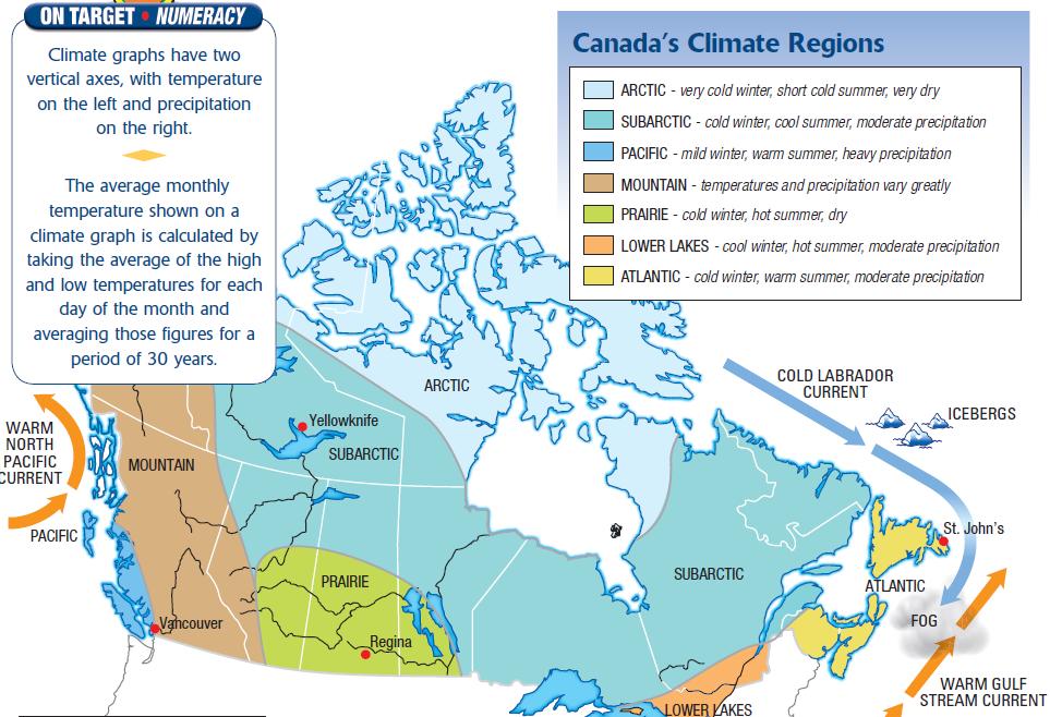
3 Canada s Climate Systems AVERAGE TEMPS FOR THESE Weather & climate in Canada vary CANADIAN greatly REGIONS from place to place and from season to season Canada extends for a great distance north to south Different elevations produce different climate conditions Coastal regions have different climates from inland regions Wind & pressure systems move weather conditions from one part of the country to another

4 Canada s Climate Systems Weather: conditions of our atmosphere over a short period of time Daily conditions Rain, snow, sun, cloudy

5 Canada s Climate Systems Climate: conditions of our atmosphere over a long period of time Months, seasons Average annual precipitation
6 Canada s Climate Systems Discuss some examples of how both weather & climate affect our lives Complete the handout Identifying weather and climate statements (Take 10 minutes)

7 Canada s Climate Regions Within Canada, areas with similar climates can be grouped together to form a climate region There are a total of eight climate regions found within our country
8
9 Canada s Climate Systems What factors influence the climate across Canada? Latitude Ocean Currents Wind & Air Masses Polar Jet Stream Elevation Large bodies of water

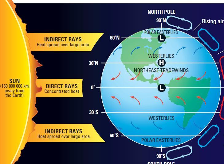
10 1. Latitude Latitude : measures how far you are north or south of the equator
11 1. Latitude An increase in latitude generally means a decrease in temperature. (Further from the equator colder) A decrease in latitude generally means an increase in temperature. (Closer to the equator warmer)
12 1. Latitude Q. Why does it get colder as latitude increases and warmer as latitude decreases? A. At low latitudes the sun s rays strike the earth at a direct angle, are more intense and heat a small area, it is warmer. At high latitudes, because of the curve of the earth, radiation strikes the earth at an indirect angle, is spread over a larger area, is less intense, and it is colder. Copy the diagram on the next slide to help with your understanding of this explanation
13

14 2. Ocean Currents Water in the ocean travels in paths called currents. Currents can either be warm or cold If the water is cold, it cools the air above it. If it is warm, it heats up the air above it

15 2. Ocean Currents Cold ocean currents: move water towards the equator. Warm ocean currents: Move water away from warm equatorial regions.

16 2. Ocean Currents North Pacific Current brings warm water / air to coast of British Columbia. Labrador Current brings cold water / air to Newfoundland & Labrador. Gulf Stream brings warm water / air to Atlantic Canada.
17 2. Ocean Currents Complete the ocean currents handout to finish this section
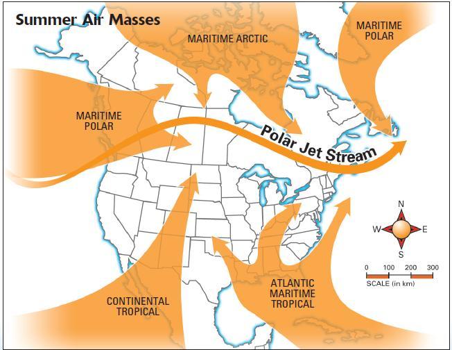
18 3. Wind & Air Masses Air mass A huge body of air with the same temperature and moisture conditions throughout. Wind air moving from one place to another. High pressure cold air sinking. (cold air is heavier) Low pressure warm air rising. (warm air is lighter) Air always moves from high pressure areas to low pressure areas. Warm air masses originate in the south. (equator) Cold air masses originate in the north. (poles)
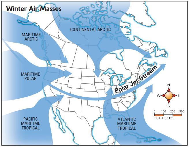
19
20

21 3. Wind & Air Masses Prevailing wind predictable winds that blow in a set pattern. In Canada the most predominant wind is the Westerlies.

22 3. Wind & Air Masses Front the leading edge of an air mass. Warm front the leading edge of a warm air mass. Cold front the leading edge of a cold air mass.


23 3. Wind & Air Masses When air pressure is low, skies are often cloudy and precipitation occurs. When air pressure is high, sunny skies prevail.


24 3. Wind & Air Masses When a cold and a warm air mass collide, warm air rises up over the cold air resulting in precipitation and storms.

25 4. Polar Jet Stream 4. Polar jet stream a fast-moving current of air at high altitudes that steers weather systems and storms from west to east. ( km/h at an altitude of m)

26 4. Polar Jet Stream It is a barrier that separates cold polar air in the north from warm tropical air in the south The clash of different air masses along the Polar jet stream front produces severe weather, including violent thunderstorms and tornadoes.
27 Weather Climate Review Weather Wise: Map Symbols Weather Wise: Map Symbols 2 Weather Wise: Jet Stream Weather Wise: Wind

28 5. Elevation Elevation is the height above sea level & impacts both temperature and precipitation across our country Temperature decreases as elevation increase, hence the snow on mountaintops

29 5. Elevation Mountains can force moisture laden air to rise and cool and drop the moisture as precipitation. This is known as orographic or relief precipitation
 evaporates")
30 5. Elevation: Orographic Precip As the air rises it cools & condenses. Clouds form & precipitation occurs The drier air descends & warms. Warm wet air is forced to rise over high land Any moisture in the air(e.g. cloud) evaporates
 Leeward - side of a mountain that is sheltered from the wind.")
31 5. Elevation: Orographic Precip Windward - side of a mountain from which the wind is blowing. Places on windward side = more rain. (Vancouver) Leeward - side of a mountain that is sheltered from the wind. Places on leeward side = less rain. (Calgary)

32 6. Large Bodies of Water Oceans & large bodies of water have a moderating effect on temperature.
33 6. Large Bodies of Water Oceans & large lakes heat up & cool down more slowly than the surrounding land so places close by will have less extreme temperatures In summer, water remains cooler than land surrounding it. Winds from the water cool the surrounding land In winter the water keeps the heat longer, and winds from the ocean warm the land.
34 6. Large Bodies of Water Places inland will have more extreme temperatures. In summer the land is warm, meaning warm temperatures. In winter the land is cold, resulting in colder temperatures. No ocean winds are nearby to moderate the temperature. Continental vs Maritime climates


35 6. Large Bodies of Water Maritime Climate located close to the ocean has moderate temperatures has cooler summers and warmer winters receives more precipitation Continental Climate located away from the ocean has extreme temperatures has warmer summers and colder winters receives less precipitation
36 Canadian Climate Analysis: Designing Climate Graphs

37 Climate Graphs Used to help study the temperature & precipitation of a particular place over a 12 month period Bar graph & line graph
38 Climate graph Features Precipitation Temperature Months Title Labels
39 Climate Graphs Bar Graph On a climate graph, bars are used to show the total amount of precipitation over the course of any given month Precipitation is indicated by mm (millimetres)
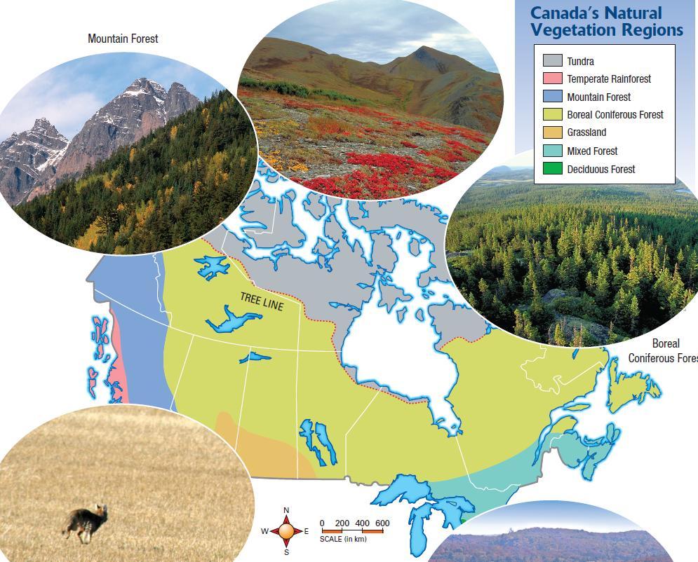
40 Climate Graphs Line Graph on a climate graph, a line is used to indicate the average monthly temperature Temperature is indicated by degrees Celsius
41 Climate Graphs Activity Complete the climate graph worksheet for Halifax, N.S. and Churchill, MB.
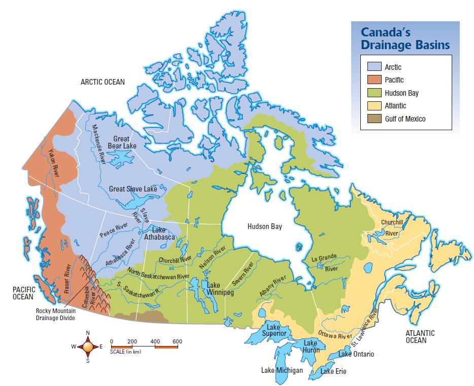
42 Activate Your Learning Section review
43 Activate Your Learning 1. Complete the Canadian Climate Systems Crossword 2. Explain the difference between weather and climate 3. Study the photographs in Figures 2.30 & 2.31 (page 77). Identify the weather condition shown in each photo, & suggest what impact those weather conditions would have on the people and the economy
44 Activate Your Learning 4. Study the climate graphs of the four cities shown in Figure 2.38 (page 88) A).Identify two cities that have a maritime climate & those that have a continental climate. Use the temp & precipitation data in the graphs to support your answer B).What do you consider to be the most important factor influencing the climate of each city? 5. Choose any two factors that influence the weather & climate in either the place you live or another location of your choice. Outline the effect that each factor has on the weather & climate conditions of that place.
45 Climate Systems & Humans
46 Climate Systems & Humans List 5 way that climate influences human activity Here is my list Types of sports activity (skiing, hockey, baseball) Closing of business or schools (snow storms) Snow clearing Materials homes built out of Types of clothing used Leisure activity (snowmobiling) Types of natural disasters(hurricanes, tornadoes) Home heating (demand for wood, oil electricity) Economic activity (farming, forestry)
47 Climate Systems & Humans How does human activity influence climate? Pollution acid rain Pollution global warming Any others?
48 Extreme Canadian Weather Complete the table as you view the video Weather Event Location/ Date Physical Impacts Human Impacts
 it helps determines what the natural vegetation will be.")
49 Canada s Natural Vegetation Systems biome a large region on the Earth, which is named for the distinct characteristics of the plants that live within it. The location of biomes is influenced by climate (temperature and precipitation) it helps determines what the natural vegetation will be. Natural vegetation the plants that are native to an area rather than those that have been planted or grown by people.
50
51 Canada s Water Systems Much of the water that falls in Canada ends up in an interconnected network of waterways that include: Lakes Rivers Wetlands Groundwater Wetlands a place where the water table is at ground level. Groundwater water found beneath the earth s surface in the spaces in soil and bedrock. Runoff water that runs off the land in rivers and lakes.
52 Drainage basin - the area of land from which all water received as precipitation flows to a particular ocean. Watershed the area of land that drains into a particular river system or body of water. Drainage divide a narrow place of high land that separates one drainage basin from another. Canada has about two million lakes! Great Lakes system is the largest of the Atlantic Ocean drainage basin 9 million Canadians and 31 million Americans depend on the water Toronto alone uses about 540 billion litres of water per year Used for agriculture, industry, manufacturing, fishing, hydroelectric and thermal power, and recreation
53

54 Which parts of this river system would be labelled youthful, mature, or old?

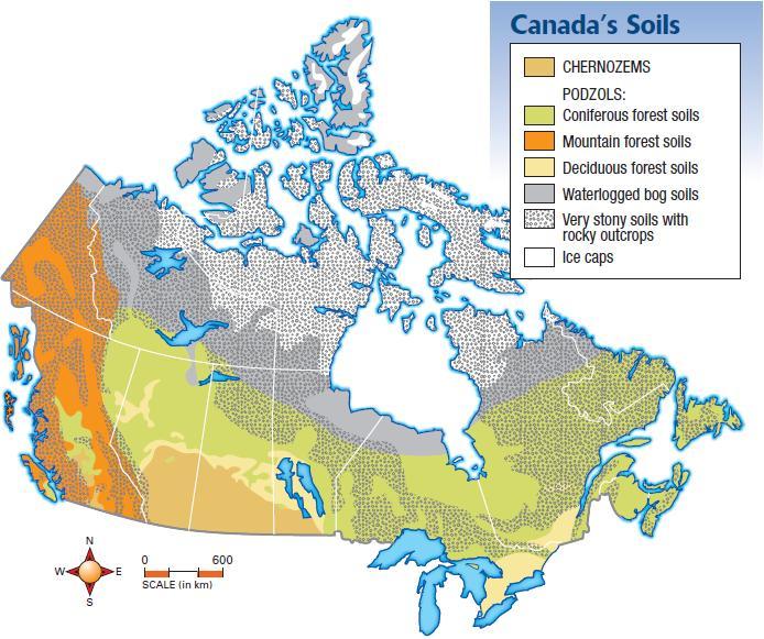
55 Canada s Soil Systems A single handful of healthy soil contains more living organisms than the number of people on the planet! Soil profile a cross of the different layers in the soil and rock below the soil. Humus dark upper layer of soil containing decayed organic material. Podzol soil found in areas covered by forests with cool, moist climates. Chernozem grassland soil rich in organic material.
56
57 Functions of soil include: A place to grow food Supports trees that provide oxygen Soaks up and purifies water People have increased the use of fertilizers to enrich soils, and pesticides to kill pests that harm crops. However fertilizers can get into water and encourage plant growth. As the plants die and decompose it reduces the oxygen in the water that fish need. Pesticides kill many of the creatures that make the soil system work well.
58 How does Canada s vegetation systems influence us? How do we influence the vegetation systems? How does Canada s water systems influence us? How do we influence the water systems? How does Canada s soil systems influence us? How do we influence the soil systems?
59 How Big is Your Ecological Footprint? Ecological footprint the amount of the Earth s resources it takes to support your lifestyle. Your ecological footprint is made up of many factors: your transportation use your water use the space you use to work and play how much money you spend how far the food you eat had to be shipped how much living space you have how much garbage you create World average is about 2.2 hectares.

60 Complete # 3 7 on page 233.
Grade 9 Geography Chapter 11 - Climate Connections
 Grade 9 Geography Chapter 11 - Climate Connections 1. Define: Weather. 2. In what way has weather affected your activities in the last two weeks? 3. Define: Climate. 4. Canada s climate is a function of
3) What is the difference between latitude and longitude and what is their affect on local and world weather and climate?
 What is the difference between latitude and longitude and what is their affect on local and world weather and climate?") www.discoveryeducation.com 1) Describe the difference between climate and weather citing an example of each. Describe how water (ocean, lake, river) has a local effect on weather and climate and provide
www.discoveryeducation.com 1) Describe the difference between climate and weather citing an example of each. Describe how water (ocean, lake, river) has a local effect on weather and climate and provide
Grade 9 Social Studies Canadian Identity. Chapter 2 Review Canada s Physical Landscape
 Grade 9 Social Studies Canadian Identity Chapter 2 Review Canada s Physical Landscape Name: Unit 1: Empowerment Terms (notes or textbook) 1. Core 2. Crust 3. Mantle 4. Magma 5. Continental drift 6. Plate
Climate versus Weather
 Climate versus Weather What is climate? Climate is the average weather usually taken over a 30-year time period for a particular region and time period. Climate is not the same as weather, but rather,
4.3 Climate (6.3.3) Explore this Phenomena. The same sun shines on the entire Earth. Explain why these two areas have such different climates.
 Explore this Phenomena. The same sun shines on the entire Earth. Explain why these two areas have such different climates.") Explore this Phenomena The same sun shines on the entire Earth. 4.3 Climate (6.3.3) Explain why these two areas have such different climates. 89 6.3.3 Climate Develop and use a model to show how unequal
Explore this Phenomena The same sun shines on the entire Earth. 4.3 Climate (6.3.3) Explain why these two areas have such different climates. 89 6.3.3 Climate Develop and use a model to show how unequal
Thermal / Solar. When air is warmed it... Rises. Solar Energy. Evaporation. Condensation Forms Clouds
 Thermal / Solar Light from the Sun is transformed into what type of energy when it hits Earth's surface? Rises When air is warmed it... Solar Energy Water moves through the water cycle using what type
1 What Is Climate? TAKE A LOOK 2. Explain Why do areas near the equator tend to have high temperatures?
 CHAPTER 17 1 What Is Climate? SECTION Climate BEFORE YOU READ After you read this section, you should be able to answer these questions: What is climate? What factors affect climate? How do climates differ
Name Date Class. well as the inland, found near the Tropics. 4. In the, or the regions near the Equator, you may find a lush
 WATER, CLIMATE, AND VEGETATION Vocabulary Activity DIRECTIONS: Fill in the Blanks Select a term from below to complete each of the following sentences. CHAPTER 1. The constant movement of water, a process
Social Studies. Chapter 2 Canada s Physical Landscape
 Social Studies Chapter 2 Canada s Physical Landscape Introduction Canada s geography its landforms and climate - has a great impact on Canadians sense of identity. Planet Earth The earth is divided into
Name Class Date. 2. What is the average weather condition in an area over a long period of time called? a. winter b. temperature c. climate d.
 Skills Worksheet Directed Reading B Section: What Is Climate? CLIMATE VS. WEATHER 1. What kind of conditions vary from day to day? a. climate b. weather c. latitude d. biome 2. What is the average weather
Global Weather Trade Winds etc.notebook February 17, 2017
 Global Weather 1 north pole northern hemisphere equator southern hemisphere south pole 2 We have seasons because of the Earth's tilt The seasons are opposite in the northern and southern hemispheres winter
Weather and Climate. Weather the condition of the Earth s atmosphere at a particular time and place
 Weather and Climate Weather the condition of the Earth s atmosphere at a particular time and place Climate the average year-after-year conditions of temperature, precipitation, winds and clouds in an area
1 What Is Climate? TAKE A LOOK 2. Explain Why do areas near the equator tend to have high temperatures?
 CHAPTER 3 1 What Is Climate? SECTION Climate BEFORE YOU READ After you read this section, you should be able to answer these questions: What is climate? What factors affect climate? How do climates differ
Contents. Section 1: Climate Factors. Section 2: Climate Types. Section 3: Climate Effects
 Contents Section 1: Climate Factors 1. Weather or Climate?.... 2 2. Elements of Climate.... 4 3. Factors Affecting Climate.... 10 4. Comparing Climates.... 15 5. Quiz 1.... 20 Section 2: Climate Types
L.O Students will learn about factors that influences the environment
 Name L.O Students will learn about factors that influences the environment Date 1. At the present time, glaciers occur mostly in areas of A) high latitude or high altitude B) low latitude or low altitude
Bell Work. REVIEW: Our Planet Earth Page 29 Document A & B Questions
 9.12.16 Bell Work REVIEW: Our Planet Earth Page 29 Document A & B Questions Intro to Climate & Weather https://www.youtube.com/watch?v=vhgyoa70q7y Weather vs. Climate Video Climate & Weather 3.1 Weather
1 What Is Climate? TAKE A LOOK 2. Explain Why do areas near the equator tend to have high temperatures?
 CHAPTER 17 1 What Is Climate? SECTION Climate BEFORE YOU READ After you read this section, you should be able to answer these questions: What is climate? What factors affect climate? How do climates differ
Science 1206 Chapter 1 - Inquiring about Weather
 Science 1206 Chapter 1 - Inquiring about Weather 1.1 - The Atmosphere: Energy Transfer and Properties (pp. 10-25) Weather and the Atmosphere weather the physical conditions of the atmosphere at a specific
GEOGRAPHY EYA NOTES. Weather. atmosphere. Weather and climate
 GEOGRAPHY EYA NOTES Weather and climate Weather The condition of the atmosphere at a specific place over a relatively short period of time Climate The atmospheric conditions of a specific place over a
CLIMATE. UNIT TWO March 2019
 CLIMATE UNIT TWO March 2019 OUTCOME 9.2.1Demonstrate an understanding of the basic features of Canada s landscape and climate. identify and locate major climatic regions of Canada explain the characteristics
3. The map below shows an eastern portion of North America. Points A and B represent locations on the eastern shoreline.
 1. Most tornadoes in the Northern Hemisphere are best described as violently rotating columns of air surrounded by A) clockwise surface winds moving toward the columns B) clockwise surface winds moving
Weather Systems Study Guide:
 Weather Systems Study Guide: 1. Draw a diagram of Earth s water cycle and label each part. 2. Explain how the water cycle works. 3. What happens in the troposphere and stratosphere? Atmosphere Level What
Tropical Moist Rainforest
 Tropical or Lowlatitude Climates: Controlled by equatorial tropical air masses Tropical Moist Rainforest Rainfall is heavy in all months - more than 250 cm. (100 in.). Common temperatures of 27 C (80 F)
November 28, 2017 Day 1
 November 28, 2017 Day 1 Air Masses & Fronts Teachers- please out the sheet (right) for the students to fill in as we go! Review: Clouds & Precipitation? What are the 4 different clouds? Status, Cumulus,
Atmosphere and Weather Revision Notes
 Atmosphere and Weather Revision Notes Atmosphere The blanket of gases that surrounds the Earth is called the atmosphere. The main gases are nitrogen (78 %), oxygen (21 %), water vapour, ozone and carbon
Weather Atmospheric condition in one place during a limited period of time Climate Weather patterns that an area typically experiences over a long
 Weather Atmospheric condition in one place during a limited period of time Climate Weather patterns that an area typically experiences over a long period of time Many factors influence weather & climate
16 Global Climate. Learning Goals. Summary. After studying this chapter, students should be able to:
 16 Global Climate Learning Goals After studying this chapter, students should be able to: 1. associate the world s six major vegetation biomes to climate (pp. 406 408); 2. describe methods for classifying
Canadian Geography Final Exam Review (September to Mid-term Exam)
") Canadian Geography 1202 - Final Exam Review (September to Mid-term Exam) Glossary Terms: Some of the following terms may be covered in the questions that follow. System Natural System Ecosystem Human System
Canadian Geography 1202 - Final Exam Review (September to Mid-term Exam) Glossary Terms: Some of the following terms may be covered in the questions that follow. System Natural System Ecosystem Human System
RR#4 - Multiple Choice
 1. The map below shows the amount of snowfall, in inches, produced by a lake-effect snowstorm in central New York State. The wind that produced this snowfall pattern most likely came from the 1) northeast
Seasons, Global Wind and Climate Study Guide
 Seasons, Global Wind and Climate Study Guide Seasons 1. Know what is responsible for the change in seasons on Earth. 2. Be able to determine seasons in the northern and southern hemispheres given the position
UNIT 12: THE HYDROLOGIC CYCLE
 UNIT 12: THE HYDROLOGIC CYCLE After Unit 12 you should be able to: o Effectively use the charts Average Chemical Composition of Earth s Crust, Hydrosphere and Troposphere, Selected Properties of Earth
Guided Notes Weather. Part 2: Meteorology Air Masses Fronts Weather Maps Storms Storm Preparation
 Guided Notes Weather Part 2: Meteorology Air Masses Fronts Weather Maps Storms Storm Preparation The map below shows North America and its surrounding bodies of water. Country borders are shown. On the
The Atmosphere. All weather occurs here 99% of water vapor found here ~75 % of total mass of the atmosphere
 The Atmosphere Structure/Layers Contains 4 major layers See E.S.R.T pg 14 o Troposphere All weather occurs here 99% of water vapor found here ~75 % of total mass of the atmosphere o Stratosphere Contains
World geography 3200/3202 Unit 2 review
 World geography 3200/3202 Unit 2 review 1. Does this statement use the terms revolve & rotate correctly? "Saturn revolves on its axis while several moons rotate around it." 2. Does this statement use the
THE EARTH S CLIMATE SYSTEM
 THE EARTH S CLIMATE SYSTEM Earth s Climate System is driven by interactions between the parts of our biosphere So.what is the Biosphere? a relatively thin layer of Earth that has conditions suitable for
Factors that Affect Climate
 Factors that Affect Climate What is climate? Climate is the average weather conditions over a long period of time Includes average temperatures and precipitation, wind patterns, humidity, air pressure
Name: Climate Date: EI Niño Conditions
 Name: Date: Base your answers to questions 1 and 2 on the maps and the passage below. The maps show differences in trade wind strength, ocean current direction, and water temperature associated with air-pressure
also known as barometric pressure; weight of the air above the surface of the earth; measured by a barometer air pressure, high
 Weather Vocabulary Vocabulary Term Meaning/Definition air mass * large bodies of air that have the similar properties throughout such as temperature, humidity, and air pressure; causes most of the weather
Global Wind Patterns
 Name: Earth Science: Date: Period: Global Wind Patterns 1. Which factor causes global wind patterns? a. changes in the distance between Earth and the Moon b. unequal heating of Earth s surface by the Sun
Weather Notes. Chapter 16, 17, & 18
 Weather Notes Chapter 16, 17, & 18 Weather Weather is the condition of the Earth s atmosphere at a particular place and time Weather It is the movement of energy through the atmosphere Energy comes from
Energy Systems, Structures and Processes Essential Standard: Analyze patterns of global climate change over time Learning Objective: Differentiate
 Energy Systems, Structures and Processes Essential Standard: Analyze patterns of global climate change over time Learning Objective: Differentiate between weather and climate Global Climate Focus Question
Climate. Annual Temperature (Last 30 Years) January Temperature. July Temperature. Average Precipitation (Last 30 Years)
 January Temperature. July Temperature. Average Precipitation (Last 30 Years)") Climate Annual Temperature (Last 30 Years) Average Annual High Temp. (F)70, (C)21 Average Annual Low Temp. (F)43, (C)6 January Temperature Average January High Temp. (F)48, (C)9 Average January Low Temp.
Climate Annual Temperature (Last 30 Years) Average Annual High Temp. (F)70, (C)21 Average Annual Low Temp. (F)43, (C)6 January Temperature Average January High Temp. (F)48, (C)9 Average January Low Temp.
above the land to be warmer, causing convection currents because of the difference in air pressure.
 Name Date Period Earth Science Unit Test Review Sheet Directions: Use my web site and/or your lab book to help to answer the following questions. 1. What type of weather does a low pressure system bring?
WATER IN THE ATMOSPHERE
 WATER IN THE ATMOSPHERE I. Humidity A. Defined as water vapor or moisture in the air (from evaporation and condensation). B. The atmosphere gains moisture from the evaporation of water from oceans, lakes,
4th Grade Social Studies First Nine Weeks
 4th Grade Social Studies First Nine Weeks Multiple Choice Identify the choice that best completes the statement or answers the question. 1 Name the mountains that are located in the eastern United States.
Prentice Hall EARTH SCIENCE
 Prentice Hall EARTH SCIENCE Tarbuck Lutgens Chapter 21 Climate 21.1 Factors That Affect Climate Factors That Affect Climate Latitude As latitude increases, the intensity of solar energy decreases. The
CORE CONCEPTS WEATHER AND CLIMATE
 CORE CONCEPTS WEATHER AND CLIMATE Key Prior Knowledge (from the 5 th Grade Matter and Energy Units) Thermal energy can be transported through radiation, conduction, and convection. The transfer of enough
Temperature Variation on Earth. Goal: Explain our atmosphere s interaction with the Sun s radiation
 Temperature Variation on Earth Goal: Explain our atmosphere s interaction with the Sun s radiation Review: What happens to Solar Radiation? 50%- absorbed by land & sea 20%- absorbed by atmosphere and clouds
Weather Atmospheric condition in one place during a limited period of time Climate Weather patterns that an area typically experiences over a long
 Weather Atmospheric condition in one place during a limited period of time Climate Weather patterns that an area typically experiences over a long period of time Many factors influence weather & climate
6. State two factors and explain how each influences the weather in Ohio. Respond in the space provided in your Answer Document.
 6. State two factors and explain how each influences the weather in Ohio. Respond in the space provided in your Answer Document. (4 points) Sample Response for Item 6 (Extended Response): Other Correct
Meteorology Study Guide
 Name: Date: Meteorology Study Guide 1. Label the following steps in the water cycle diagram. Be sure to include arrows to show the flow of water through the cycle. - Transpiration - Precipitation -Evaporation
Energy Transfer in the Atmosphere
 Energy Transfer in the Atmosphere Textbook pages 436 459 Section 10.2 Summary Before You Read What do you think causes wind? Write your thoughts in the lines below. Mark the Text In Your Own Words Highlight
Climate.tgt, Version: 1 1
 Name: Key Concepts Choose the letter of the best answer. (5 points each) 1. 2. 3. 4. 5. 6. 7. 8. 9. 10. Date: A city located in the middle of North America experiences extreme temperature changes during
Definitions Weather and Climate Climates of NYS Weather Climate 2012 Characteristics of Climate Regions of NYS NYS s Climates 1.
 Definitions Climates of NYS Prof. Anthony Grande 2012 Weather and Climate Weather the state of the atmosphere at one point in time. The elements of weather are temperature, t air pressure, wind and moisture.
How strong does wind have to be to topple a garbage can?
 How strong does wind have to be to topple a garbage can? Imagine winds powerful enough to pick up a truck and toss it the length of a football field. Winds of this extreme sometimes happen in a tornado.
according to and water. High atmospheric pressure - Cold dry air is other air so it remains close to the earth, giving weather.
 EARTH'S ATMOSPHERE Composition of the atmosphere - Earth's atmosphere consists of nitrogen ( %), oxygen ( %), small amounts of carbon dioxide, methane, argon, krypton, ozone, neon and other gases such
Ch. 3: Weather Patterns
 Ch. 3: Weather Patterns Sect. 1: Air Mass & Fronts Sect. 2: Storms Sect. 3: Predicting the Weather Sect. 4: Weather forecasters use advanced technologies Ch. 3 Weather Fronts and Storms Objective(s) 7.E.1.3
Name: Regents Earth Science. Weather and Climate - Review Questions
 Name: Regents Earth Science Weather and Climate - Review Questions Date: Thayer - 279 1. People sometimes release substances into the atmosphere to increase the probability of rain by A) raising the air
Chapter 2: Physical Geography
 Chapter 2: Physical Geography Pg. 39-68 Learning Goals for Chp2: q q q q q Explain how the Earth moves in space and why seasons change. Outline the factors that influence climate and recognize different
Chapter 2 Planet Earth
 Chapter 2 Planet Earth Section Notes Earth and the Sun s Energy Water on Earth The Land Close-up The Water Cycle World Almanac Major Eruptions in the Ring of Fire Quick Facts Chapter 2 Visual Summary Video
10.1 TEMPERATURE, THERMAL ENERGY AND HEAT Name: Date: Block: (Reference: pp of BC Science 10)
") 10.1 TEMPERATURE, THERMAL ENERGY AND HEAT Name: Date: Block: (Reference: pp. 424-435 of BC Science 10) kinetic molecular theory: explains that matter is made up of tiny that are constantly. These atoms
10.1 TEMPERATURE, THERMAL ENERGY AND HEAT Name: Date: Block: (Reference: pp. 424-435 of BC Science 10) kinetic molecular theory: explains that matter is made up of tiny that are constantly. These atoms
COMPOSITION OF THE ATMOSPHERE
 Name Air COMPOSITION OF THE ATMOSPHERE 1. What are the two most abundant gases in the atmospherere? 2. Why do you think the percentage of water vapor in the air varies? 3. Would you classify carbon dioxide
Climates of NYS. Definitions. Climate Regions of NYS. Storm Tracks. Climate Controls 10/13/2011. Characteristics of NYS s Climates
 Definitions Climates of NYS Prof. Anthony Grande 2011 Weather and Climate Weather the state of the atmosphere at one point in time. The elements of weather are temperature, air pressure, wind and moisture.
Factors that Affect Climate
 Factors that Affect Climate What is climate? Climate is the average weather conditions over a long period of time Includes average temperatures and precipitation, wind patterns, humidity, air pressure
Unit 2. United States Physical Geography
 Unit 2 United States Physical Geography Physical Geography U.S. extends from the Atlantic to Pacific U.S. is the 3rd largest country U.S. has fertile soils, vast forests, and variety of minerals All major
Background: What is Weather?
 Weather Maps Background: What is Weather? Weather is the day-to-day state of the atmosphere. The interaction of three important factors result in weather systems: air temperature, air pressure, and the
4. Fill in the table about the 4 different types of air masses. Air Masses Source Region Type of Air Symbol
 Packet #12: Weather & Climate Name: Per: Reading Guide: Chapter 24.1 (Read and study text pages 601-604) Understanding Air Masses 5a. Students know how differential heating of Earth results in circulation
Chapter 7 Properties of the Atmosphere
 14. Day Breezes H L Chapter 7 Properties of the Atmosphere Questions Pages 177 179 1. (3) 2. (4) 3. (4) 4. (3) 5. (2) 6. (3) 7. (2) 8. (2) 9. (3) 10. (1) 11. (4) 12. (2) Questions Pages 186 188 13. (3)
Multiple Choice Identify the choice that best completes the statement or answers the question.
 CH.15 practice TEST Multiple Choice Identify the choice that best completes the statement or answers the question. 1) The short-term state of the atmosphere is called a) climate. c) water cycle. b) weather.
Forecasting Weather: Air Masses and Fronts
 Forecasting Weather: Air Masses and Fronts Weather is a combination of local conditions at any one time. It's what's happening outside right now, right here. Weather includes: Temperature Humidity Air
Climate and the Atmosphere
 Climate and Biomes Climate Objectives: Understand how weather is affected by: 1. Variations in the amount of incoming solar radiation 2. The earth s annual path around the sun 3. The earth s daily rotation
Meteorology. Chapter 15 Worksheet 1
 Chapter 15 Worksheet 1 Meteorology Name: Circle the letter that corresponds to the correct answer 1) The Tropic of Cancer and the Arctic Circle are examples of locations determined by: a) measuring systems.
Name Period 4 th Six Weeks Notes 2013 Weather
 Name Period 4 th Six Weeks Notes 2013 Weather Radiation Convection Currents Winds Jet Streams Energy from the Sun reaches Earth as electromagnetic waves This energy fuels all life on Earth including the
1. Which weather map symbol is associated with extremely low air pressure? A) B) C) D) 2. The diagram below represents a weather instrument.
 B) C) D) 2. The diagram below represents a weather instrument.") 1. Which weather map symbol is associated with extremely low air pressure? 2. The diagram below represents a weather instrument. Which weather variable was this instrument designed to measure? A) air pressure
1. Which weather map symbol is associated with extremely low air pressure? 2. The diagram below represents a weather instrument. Which weather variable was this instrument designed to measure? A) air pressure
Unit 2 Meteorology Test **Please do not write on this test** 5. El Nino & La Nina 6. Photosynthesis 7. Coriolis Effect 8.
 Matching (2 points each) 1. weather 2. climate 3. Greenhouse Effect 4. Convection Unit 2 Meteorology Test **Please do not write on this test** 5. El Nino & La Nina 6. Photosynthesis 7. Coriolis Effect
Unit 4 Review Guide: Weather
 Unit 4 Review Guide: Weather Weather: The condition of the atmosphere at a specific time and place. Freezing: To become hardened into ice or into a solid body Deposition: The change in state of matter
Page 1. Name:
 Name: 1) As the difference between the dewpoint temperature and the air temperature decreases, the probability of precipitation increases remains the same decreases 2) Which statement best explains why
GLOBAL CLIMATES FOCUS
 which you will learn more about in Chapter 6. Refer to the climate map and chart on pages 28-29 as you read the rest of this chapter. FOCUS GLOBAL CLIMATES What are the major influences on climate? Where
EQ: Discuss main geographic landforms of the U.S. & Canada and examine varied landforms in relation to their lifestyles.
 EQ: Discuss main geographic landforms of the U.S. & Canada and examine varied landforms in relation to their lifestyles. Places & Terms for Discussion Appalachian Mountains Great Plains Canadian Shield
Week: Dates: 3/2 3/20 Unit: Climate
 clementaged.weebly.com Name: EVEN Period: Week: 28 30 Dates: 3/2 3/20 Unit: Climate Monday Tuesday Wednesday Thursday Friday 2 O 3 E *Vocabulary *Water in the Atmosphere and Clouds Notes *Cloud Drawings
Grade 8 Science. Unit 1: Water Systems on Earth Chapter 1
 Grade 8 Science Unit 1: Water Systems on Earth Chapter 1 Effects of Water? Churchill River Large Ocean Wave How do you use water? House Hold Use Personal Use Recreational Activities Water Distribution
Class Notes: Water and Climate. Ever since the outgassing of water vapor years ago, Earth has been recycling its water supply. Water Cycle -!
 Name: Date: Period: Water and Climate The Physical Setting: Earth Science I. The Water Cycle Ever since the outgassing of water vapor years ago, Earth has been recycling its water supply Earth has not
4 Changes in Climate. TAKE A LOOK 2. Explain Why is more land exposed during glacial periods than at other times?
 Name Class CHAPTER 3 Date Climate 4 Changes in Climate SECTION National Science Education Standards BEFORE YOU READ After you read this section, you should be able to answer these questions: ES 1k, 2a
The Transfer of Heat
 The Transfer of Heat Outcomes: S2-4-03 Explain effects of heat transfer within the atmosphere and hydrosphere on the development and movement of wind and ocean currents. Coriolis Effect In our ecology
THE ATMOSPHERE IN MOTION
 Funding provided by NOAA Sectoral Applications Research Project THE ATMOSPHERE IN MOTION Basic Climatology Oklahoma Climatological Survey Factor 1: Our Energy Source Hi, I m the Sun! I provide 99.9999+
Go With the Flow From High to Low Investigating Isobars
 Go With the Flow From High to Low Investigating Isobars Science 10 Mrs. Purba Air Masses The air over a warm surface can be heated, causing it to rise above more dense air. The result is the formation
Pilots watch the clouds, because clouds can indicate the kind of weather in store for a flight.
 Low stratus Cumulonimbus Pilots watch the clouds, because clouds can indicate the kind of weather in store for a flight. FILL IN THE BLANKS OR CIRCLE ONE: A. Stratus means flat or on one level. Low stratus
Weather is the of the Earth s atmosphere at a place and time. It is the movement of through the atmosphere o Energy comes from the
 Weather Notes Weather Weather is the of the Earth s atmosphere at a place and time It is the movement of through the atmosphere o Energy comes from the The sun is the force that weather The sun s energy
Energy and Seasons A B1. 9. Which graph best represents the general relationship between latitude and average surface temperature?
 Energy and Seasons A B1 1. Which type of surface absorbs the greatest amount of electromagnetic energy from the Sun? (1) smooth, shiny, and light colored (2) smooth, shiny, and dark colored (3) rough,
Geology is the study of the structure and substance of the earth. The earth s physical features have been created by many geological events:
 UNIT 1 NOTES : GEOLOGY & THE EARTH S PHYSICAL STRUCTURE GEOLOGY & THE EARTH S PHYSICAL STRUCTURE Geology is the study of the structure and substance of the earth. The earth s physical features have been
What a Hurricane Needs to Develop
 Weather Weather is the current atmospheric conditions, such as air temperature, wind speed, wind direction, cloud cover, precipitation, relative humidity, air pressure, etc. 8.10B: global patterns of atmospheric
Clouds and Rain Unit (3 pts)
") Name: Section: Clouds and Rain Unit (Topic 8A-2) page 1 Clouds and Rain Unit (3 pts) As air rises, it cools due to the reduction in atmospheric pressure Air mainly consists of oxygen molecules and nitrogen
Name: Section: Clouds and Rain Unit (Topic 8A-2) page 1 Clouds and Rain Unit (3 pts) As air rises, it cools due to the reduction in atmospheric pressure Air mainly consists of oxygen molecules and nitrogen
Mid-latitude Cyclones & Air Masses
 Lab 9 Mid-latitude Cyclones & Air Masses This lab will introduce students to the patterns of surface winds around the center of a midlatitude cyclone of low pressure. The types of weather associated with
Adopt a Drifter Lesson Plan by Mary Cook, Middle School Science Teacher, Ahlf Jr. High School, Searcy, Arkansas
 Adopt a Drifter Lesson Plan by Mary Cook, Middle School Science Teacher, Ahlf Jr. High School, Searcy, Arkansas Do Ocean Surface Currents Influence Climate? Objectives Students will construct climographs
World Geography Chapter 3
 World Geography Chapter 3 Section 1 A. Introduction a. Weather b. Climate c. Both weather and climate are influenced by i. direct sunlight. ii. iii. iv. the features of the earth s surface. B. The Greenhouse
How Can You Predict Weather Changes?
 How Can You Predict Weather Changes? How to Predict Weather Meteorologists make weather predictions daily. They use the same processes that you will. They collect weather data. They plot the data on maps.
Prentice Hall EARTH SCIENCE
 Prentice Hall EARTH SCIENCE Tarbuck Lutgens Chapter 21 Climate 21.1 Factors That Affect Climate Factors That Affect Climate Latitude As latitude increases, the intensity of solar energy decreases. The
25.1 Air Masses. Section 25.1 Objectives
 Section 25.1 Objectives Explain how an air mass forms. List the four main types of air masses. Describe how air masses affect the weather of North America. Air Masses 25.1 Air Masses Differences in air
2. Identify each of the following statements as a reference to weather or climate.
 World Geography 3200/3202 Unit 2 Questions Name: Read Pages 54-55 1. Explain the difference between Weather and Climate. 2. Identify each of the following statements as a reference to weather or climate.
What is Climate? Understanding and predicting climatic changes are the basic goals of climatology.
 What is Climate? Understanding and predicting climatic changes are the basic goals of climatology. Climatology is the study of Earth s climate and the factors that affect past, present, and future climatic