Explain the impact of location, climate, natural resources, and population distribution on Europe. a. Compare how the location, climate, and natural
|
|
|
- Angel Greene
- 6 years ago
- Views:
Transcription

1 SS6G10
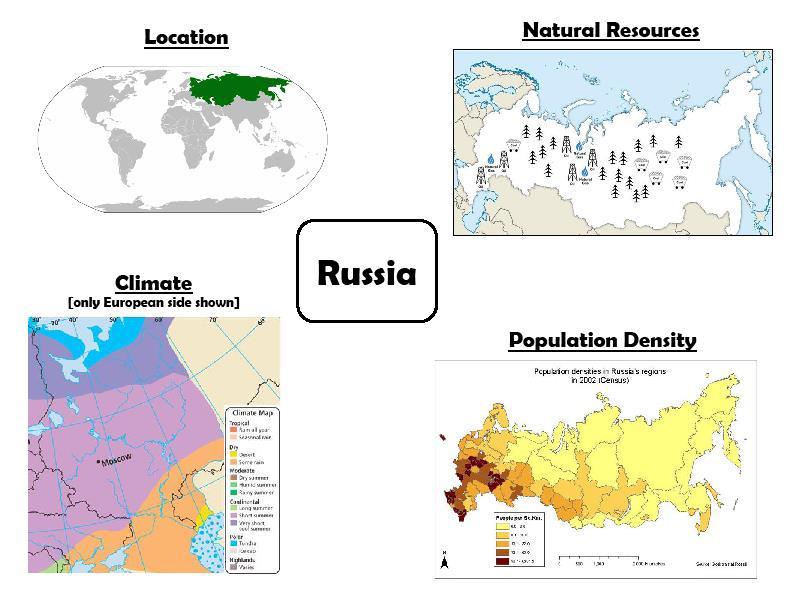
2 Explain the impact of location, climate, natural resources, and population distribution on Europe. a. Compare how the location, climate, and natural resources of Germany, the United Kingdom and Russia impact trade and affect where people live.
3 Location Climate and Natural Resources Where do people live in Europe? Europe How does Climate affect where people live in Europe? How does location affect where people live? United Kingdom Russia Germany How does Climate affect where people live? How do Natural resources affect where people live? How does location affect how people trade? How does Climate affect how people trade? How do Natural resources affect how people trade?
4
5
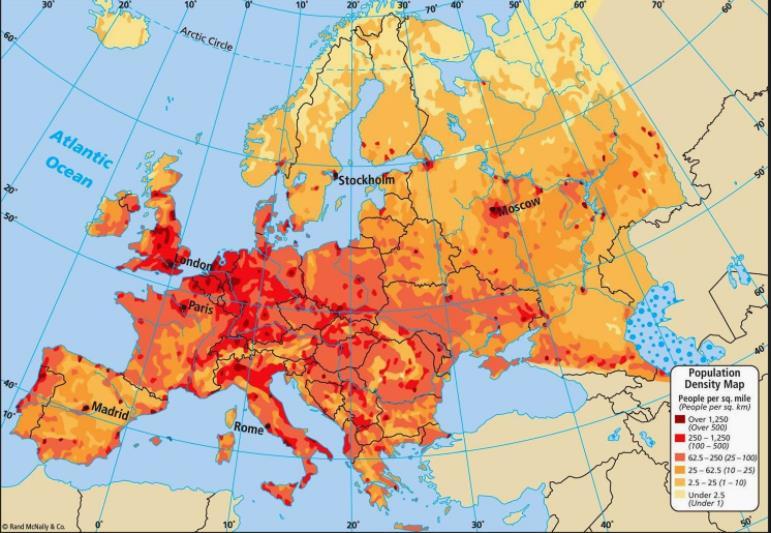
6 Europe Where do people live in Europe? Central Europe is the most densely populated. How does Climate affect where people live in Europe?
7
8
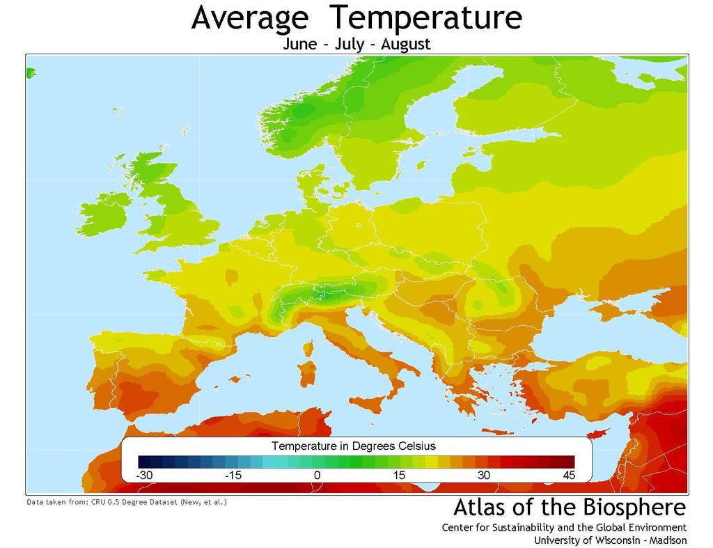
9 Europe Where do people live in Europe? Central Europe is the most densely populated. How does Climate affect where people live in Europe? Many live in the southern part to avoid the colder temperatures in the north.
10 The location of a country, its climate, and its natural resources have a tremendous impact on where its people live, how they make a living, and how they trade with other countries. The United Kingdom may be a small island nation, but it has had a tremendous impact on world history!

11

12
13 How does location affect where people live? How does Climate affect where people live? How do Natural resources affect where people live? How does location affect how people trade? How does Climate affect how people trade? How do Natural resources affect how people trade? United Kingdom Can easily trade with much of Europe by ship


14 Has anyone traveled far up North? What was the weather like? What do you know about the climate of Canada? What would be your guess about the climate of the United Kingdom? United Kingdom Canada Central America You are here Africa
15 Although the UK is located very far north, a current of warm ocean water called the Gulf Stream flows by the British Isles and keeps temperatures mild.

16 watcyc.currents/the-role-of-ocean-currents-in-climate/


17 Major Cities in the United Kingdom
18 How does location affect where people live? United Kingdom Many people live in the cities because it is a small island with not much farming How does Climate affect where people live? They live in the southern part where it is warmer How do Natural resources affect where people live? How does location affect how people trade? Can easily trade with much of Europe by ship How does Climate affect how people trade? They can trade year round How do Natural resources affect how people trade?
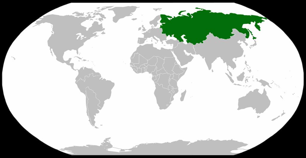
19 The island of Great Britain has a jagged coastline with good harbors for trading vessels. Great Britain is divided into a highland zone (north and west) and a lowland zone (south and east). Important natural resources like coal, oil, and natural gas are found in the mountainous highland zone.
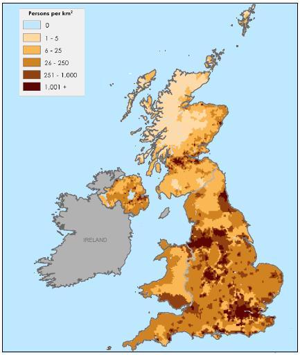
20 Most Britons live in the lowland zone, where farming and England s major cities are located. Only about 1% of British people work in agriculture, and the country has to import about one-third of its food. Most live in Urban areas. (Cities or towns) More than 7 million people live in London!
21 Great Britain also has thriving manufacturing industries, including iron and steel production and electronics.
22 Large reserves of oil and natural gas found recently in the North Sea have made Great Britain a major supplier of those resources.
23 How does location affect where people live? United Kingdom Many people live in the cities because it is a small island with not much farming How does Climate affect where people live? They live in the southern part where it is warmer How do Natural resources affect where people live? How does location affect how people trade? People live in cities (urban) where manufacturing jobs are located that use the natural resources of coal and oil Can easily trade with much of Europe by ship How does Climate affect how people trade? They can trade year round How do Natural resources affect how people trade? Have to import about one third of its food.

24

25
26 Spans 2 continents: Europe & Asia! So wide that a train trip across takes a week! (It is the largest country in the world) Shares a border with 15 countries Eastern side is bound by Pacific Ocean Northern side is bounded by Arctic Ocean At its closest point, Russia & US are only 3 miles apart across Bering Strait!
27 How does location affect where people live? How does Climate affect where people live? How do Natural resources affect where people live? How does location affect how people trade? How does Climate affect how people trade? How do Natural resources affect how people trade? Russia Worlds largest country shares a border with 15 other countries

28 The Gulf Stream does not affect Russia; therefore, due to its location, Russia s climate is severe in many areas. In some areas it is so cold that the soil is permanently frozen which hinders farming and economic development. Russia is unfavorably located in relation to major sea lanes of the world which further inhibits trade.


29 Most citizens live in western Russia on the European Plain Russia s major cities, farms, grazing land for livestock, and the country s warmest temperatures are located in western Russia.
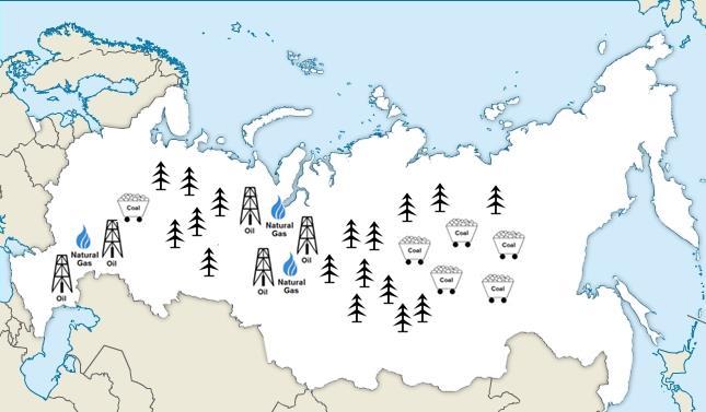
30 How does location affect where people live? How does Climate affect where people live? Russia Russia is a far north country but does not benefit from the warm gulf stream. The Atlantic ocean brings very cold temperatures from the archtic. People live in the European side where it is warmer. Most of Russia is extremely cold much of the year. How do Natural resources affect where people live? How does location affect how people trade? Worlds largest country shares a border with 15 other countries How does Climate affect how people trade? How do Natural resources affect how people trade?
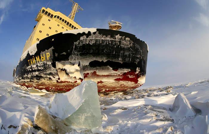
31 Russia has a very cold climate, thanks to its location near the Arctic Ocean. Russia does not get a lot of rainfall, and only about 10% of Russia s total land is suitable for agriculture. Grains like wheat and barley are major crops. Russia imports a lot of its food, particularly meat.
32
33
34
35
36
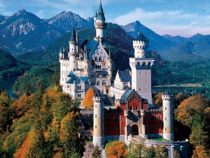
37 Russia is rich in mineral resources, with huge deposits of coal, oil, and natural gas, and massive forests. Unfortunately, it is difficult and expensive to harvest and transport these resources because of the harsh climate and remote locations.
38 Many Russian goods are transported by railroad because rivers and major ports are blocked by ice in the winter. Russia s mining, manufacturing, and fishing industries are fueled by the country s natural resources.
39
40 How does location affect where people live? How does Climate affect where people live? How do Natural resources affect where people live? How does location affect how people trade? How does Climate affect how people trade? How do Natural resources affect how people trade? Russia Russia is a far north country but does not benefit from the warm gulf stream. The Atlantic ocean brings very cold temperatures from the arctic. People live in the European side where it is warmer. Most of Russia is extremely cold much of the year. Many natural resources are in the Cold Asia part of Russia, so some people live in a harsh difficult climate to get to them. Worlds largest country shares a border with 15 other countries Many of Russia s ports are in the arctic ocean which freezes over during the winter so they have to do much of their trade with trains. it is difficult and expensive to harvest and transport these resources because of the harsh climate and remote locations.
41

42
43
44 Germany is a very prosperous nation, with one of the largest populations in Europe and the strongest economy. Germany truly owes much of its success to its location, climate, and natural resources! Germany enjoys a moderate climate with warm, mild summers and cool winters.

45 Due to Germany s location, its climate is moderate Germany is in central Europe, so it can trade easily with other European countries. Germany s location is favorable for producing many crops The Rhine River allows Germany to transport goods to the North Sea and the Atlantic Ocean


46 Most Germans live in western Germany Ruhr Valley The Ruhr Valley in western German is the most densely populated area in the country filled with factories, cities, and towns.


47 Germany s Germany Climate Germany s climate is moderate with warm, mild summers and cool winters. This allows people to live all over Germany.
48 Although Germany produces many crops, and live all over Germany, manufacturing drives the country s economy. Many live in cities and towns near the Rhine river. Most Germans live in the cities and towns of western Germany. (East Germany use to be part of the U.S.S.R. (Soviet Union) Many people fled the Soviet Union in favor of West Germany.
49 How does location affect where people live? How does Climate affect where people live? Germany Many people live in western Germany. East Germany was apart of the Soviet Union after World War II and many people moved to the democratic western part. Germany enjoys a moderate climate with warm moderate summers and cool winters that allow people to live all over Germany How do Natural resources affect where people live? How does location affect how people trade? How does Climate affect how people trade? Germany is in central Europe and can easily trade with many countries. The moderate weather allows for trade year round. How do Natural resources affect how people trade?
50
51

52 Population: 82,000,000 Germany is one of the most densely populated countries in Europe 85% of population live in urban areas Berlin is the largest city and capital
53

54
55 How does location affect where people live? How does Climate affect where people live? How do Natural resources affect where people live? How does location affect how people trade? How does Climate affect how people trade? How do Natural resources affect how people trade? Germany Many people live in western Germany. East Germany was apart of the Soviet Union after World War II and many people moved to the democratic western part. Germany enjoys a moderate climate with warm moderate summers and cool winters that allow people to live all over Germany Germany has many resources for manufacturing. The good farm lands allows them to produce much of Europe's food. Germany is in central Europe and can easily trade with many countries. The moderate weather allows for trade year round. They can be easily transported up the Rhine river to the Atlantic Ocean for trade.
What is the largest country in the world? Russia
 What is the largest country in the world? #1 Russia CSCOPE 2007 2 Russia Dimensions #2-3 Spans 11 Time Zones From East to West: Gulf of Finland to Alaska From North to South: Above the Arctic Circle to
4th Grade Social Studies First Nine Weeks
 4th Grade Social Studies First Nine Weeks Multiple Choice Identify the choice that best completes the statement or answers the question. 1 Name the mountains that are located in the eastern United States.
Chapter 6, Part Colonizers arriving in North America found extremely landscapes. It looked different to region showing great.
 Social Studies 9 Unit 1 Worksheet Chapter 6, Part 1. 1. Colonizers arriving in North America found extremely landscapes. It looked different to region showing great. 2. The Earth is years old and is composed
EQ: Discuss main geographic landforms of the U.S. & Canada and examine varied landforms in relation to their lifestyles.
 EQ: Discuss main geographic landforms of the U.S. & Canada and examine varied landforms in relation to their lifestyles. Places & Terms for Discussion Appalachian Mountains Great Plains Canadian Shield
The United States & Canada. A Regional Study of Anglo America
 A Regional Study of Anglo America Landform Regions of the United States & Canada world leaders in agricultural and industrial production because of... VAST LANDS stretch from the Atlantic Ocean on the
Name three countries in Europe.
 Name three countries in Europe. I will be able to identify the 5 themes of geography for Europe and locate the countries and capitals of Europe and the major physical features. People: Past: Through the
New National Curriculum Geography Skills Planning KS1
 New National Curriculum Geography Skills Planning KS1 Enquiry Question Objective-essential knowledge skills or understanding Locational Knowledge Standards /Success Criteria Lesson progression over half
Physical Geography of the United States and Canada Chapter 5 A Land of Contrasts
 Physical Geography of the United States and Canada Chapter 5 A Land of Contrasts Land Area Together the U.S. and Canada cover more than 7 million square miles. In total area, Canada ranks 2 nd and the
NATIONAL CURRICULUM GEOGRAPHY PLANNING OVERVIEW
 GEOGRAPHY AUTUMN TERM SPRING TERM SUMMER TERM Year 1 Hunting and Hiding Me and My Wonderful World Beside The Sea identify seasonal and daily weather patterns in the United Kingdom and the location of hot
PHYSICAL FEATURES OF EUROPE. Europe Unit
 PHYSICAL FEATURES OF EUROPE Europe Unit PENINSULA OF PENINSULAS Europe is a large peninsula that consists of many smaller peninsulas Most places in Europe are no more than 300 miles from an ocean or sea
forest tropical jungle swamp marsh prairie savanna pampas Different Ecosystems (rainforest)
") Different Ecosystems forest A region of land that is covered with many trees and shrubs. tropical jungle (rainforest) swamp A region with dense trees and a variety of plant life. It has a tropical climate.
Different Ecosystems forest A region of land that is covered with many trees and shrubs. tropical jungle (rainforest) swamp A region with dense trees and a variety of plant life. It has a tropical climate.
Unit 2. United States Physical Geography
 Unit 2 United States Physical Geography Physical Geography U.S. extends from the Atlantic to Pacific U.S. is the 3rd largest country U.S. has fertile soils, vast forests, and variety of minerals All major
Complete Geography Overview: Year 1 to Year 6
 Option 1 Complete Geography Overview: Year 1 to Year 6 Autumn Term Spring Term Summer Term Year 1 Where do I live? Around the World The Four Seasons Year 2 At the Farm Let s go on Safari My World and Me
4 th Grade Virginia Studies SOL Review Packet Geography of Virginia. 1. The Algonquian language group of Indians lived in what region of Virginia?
 4 th Grade Virginia Studies SOL Review Packet Geography of Virginia 1. The Algonquian language group of Indians lived in what region of Virginia? A. Allegheny B. Piedmont C. Ridge and Valley D. Tidewater
4th Grade U.S. Regional Geography
 4th Grade U.S. Regional Geography Multiple Choice Identify the choice that best completes the statement or answers the question. What does the term mainland mean in the sentence above? A the continent
Unit 1: Geography. For additional information, refer to this website: 1 G e o g r a p h y
 Unit 1: Geography For additional information, refer to this website: http://mryoungtms.weebly.com/ 1 G e o g r a p h y Continents and Oceans SOL USI. 2a Essential Understanding: Continents are large land
World Geography Chapter 3
 World Geography Chapter 3 Section 1 A. Introduction a. Weather b. Climate c. Both weather and climate are influenced by i. direct sunlight. ii. iii. iv. the features of the earth s surface. B. The Greenhouse
September 14, 2013 Objective: How does geography impact history? What important features exist that have shaped societies?
 Lowenhaupt 1 September 14, 2013 Objective: How does geography impact history? What important features exist that have shaped societies? Warm-Up: In your binder, answer the following question: Imagine you
Sec$on 1: Geography and Early China. How does China s geography affect the culture?
 Sec$on 1: Geography and Early China How does China s geography affect the culture? Con$nents of the World Label the continents. Where is China located? Where is China located? In your groups, begin filling
Contents. Section 1: Climate Factors. Section 2: Climate Types. Section 3: Climate Effects
 Contents Section 1: Climate Factors 1. Weather or Climate?.... 2 2. Elements of Climate.... 4 3. Factors Affecting Climate.... 10 4. Comparing Climates.... 15 5. Quiz 1.... 20 Section 2: Climate Types
Geography Progression
 Geography Progression This document aims to track expectations for History within George Grenville Academy. What the National Curriculum says: KS1: Locational Knowledge: Name and locate the world s 7 continents
Geography Long Term Plan 2018
 Geography Long Term Plan 2018 Geography Co-ordinator: Megan Frost A high-quality geography education should inspire in pupils a curiosity and fascination about the world and its people that will remain
Landforms in Canada. Canada is made up of three dis;nct types of landforms: Canadian Shield Highlands Lowlands
 Canada s Landforms What is a Landform? A landform is any physical feature of the Earth s surface having a characteris;c, recognizable shape, produced by natural causes. Landforms include major features
The Geography Curriculum at Coston Primary
 The Geography Curriculum at Coston Primary Years Year 1 Year 2 Summer We are learning about where food is farmed and in The physical features of farms. The human features of farms. The characteristics
... Europe. Based on Bloom s Taxonomy. Environment Interactions Movement. Human & Location. Regions. Place
 ... Europe Location Place Human & Environment Interactions Movement Regions LEVEL 1 Knowledge Match Show or Label List Information Recall Details (5Ws + H) Find Information LEVEL 2 Comprehension Describe
Socials Studies. Chapter 3 Canada s People 3.0-Human Geography
 Socials Studies Chapter 3 Canada s People 3.0-Human Geography Physical Geography Study of the natural features of the Earth s surface including landforms, climate, ocean currents and flora and fauna Human
2 Georgia: Its Heritage and Its Promise
 TERMS region, erosion, fault, elevation, Fall Line, aquifer, marsh, climate, weather, precipitation, drought, tornado, hurricane, wetland, estuary, barrier island, swamp PLACES Appalachian Mountains, Appalachian
Geography Mile Post 1
 Mile Post 1 Use world maps, atlases and globes to identify the UK and its countries, as well as the countries, continents and oceans studied at this key stage Key Skills IPC learning Goals 1.11 Be able
Holy Trinity 3-16 School. Geography Overview (Primary)
") Holy Trinity 3-16 School Key Stage 1 Geography Overview (Primary) Year Autumn 1 Autumn 2 Spring1 Spring 2 Summer 1 Summer 2 Y1 Dear Zoo Castles Gadgets and Gizmos (UK) Name, locate and identify characteristics
Holy Trinity 3-16 School Key Stage 1 Geography Overview (Primary) Year Autumn 1 Autumn 2 Spring1 Spring 2 Summer 1 Summer 2 Y1 Dear Zoo Castles Gadgets and Gizmos (UK) Name, locate and identify characteristics
Year 1 name and locate the four countries and capital cities of the United Kingdom and its surrounding seas
 Long Term Objective Organisation for Geography Please note that only statutory requirements should be included in this document; any supplementary guidance and information should be retained by Subject
World Industrial Regions
 World Industrial Regions North America Industrialized areas in North America Changing distribution of U.S. manufacturing Europe Western Europe Eastern Europe East Asia Manufacturing Regions Fig. 11-3:
Tropical Moist Rainforest
 Tropical or Lowlatitude Climates: Controlled by equatorial tropical air masses Tropical Moist Rainforest Rainfall is heavy in all months - more than 250 cm. (100 in.). Common temperatures of 27 C (80 F)
Tuition, Medical and Behaviour Support Service
 Tuition, Medical and Behaviour Support Service Curriculum Policy - Primary Geography Reviewed: October 2018 Next Review: October 2019 Responsibility: Andrea Snow AIMS AND PRINCIPLES The national curriculum
GEOGRAPHY CURRICULUM OVERVIEW
 GEOGRAPHY CURRICULUM OVERVIEW Geographical knowledge Progression Statement Autumn Spring Summer Year 1 UK and Local Area: Physical Themes: Name, locate and identify characteristics of the 4 countries and
Global Wind Patterns
 Name: Earth Science: Date: Period: Global Wind Patterns 1. Which factor causes global wind patterns? a. changes in the distance between Earth and the Moon b. unequal heating of Earth s surface by the Sun
Geography Long Term Plan. Autumn Spring Summer
 Geography Long Term Plan Autumn Spring Summer Year 1 Working Scientifically covered throughout the year Location Geography of UK Name, locate and identify characteristics of the four countries and capital
Our climate system is based on the location of hot and cold air mass regions and the atmospheric circulation created by trade winds and westerlies.
 CLIMATE REGIONS Have you ever wondered why one area of the world is a desert, another a grassland, and another a rainforest? Or have you wondered why are there different types of forests and deserts with
Chapter 32. Australia & New Zealand
 Chapter 32 Australia & New Zealand Lesson 1: Physical Geography of Australia & New Zealand Landforms Australia lies between the Pacific and Indian Oceans in the Southern Hemisphere. Although an island,
Simple Solutions Social Studies Level 2. Level 2. Social Studies. Help Pages
 Level 2 Social Studies 147 148 adobe houses with bricks made of clay and straw ancestor a family member who lived before us appoint choose; leaders can appoint others barter trading one thing for another
The study of Geography and the use of geographic tools help us view the world in new ways.
 S How does Geography help us understand our world? What factors shape the Earth s different environments? 7.1.9 7.2.9 BIG IDEAS COMPETENCIES Text pages or The study of Geography and the use of geographic
1. Match the words in the first column to the meaning in the second column. [5]
![1. Match the words in the first column to the meaning in the second column. [5]](/thumbs/96/126839765.jpg "1. Match the words in the first column to the meaning in the second column. [5]") Exercise 1: [40 POINTS] 1. Match the words in the first column to the meaning in the second column. [5] Equator Around earth between the Equator and the Poles. Greenwich meridian Half of earth. Longitude
Exercise 1: [40 POINTS] 1. Match the words in the first column to the meaning in the second column. [5] Equator Around earth between the Equator and the Poles. Greenwich meridian Half of earth. Longitude
Chapter 32. Australia & New Zealand
 Chapter 32 Australia & New Zealand Lesson 1: Physical Geography of Australia & New Zealand Landforms Australia lies between the Pacific and Indian Oceans in the Southern Hemisphere. Although an island,
The continent of Antarctica Resource N1
 The continent of Antarctica Resource N1 Prepared by Gillian Bunting Mapping and Geographic Information Centre, British Antarctic Survey February 1999 Equal area projection map of the world Resource N2
MARS AREA SCHOOL DISTRICT CURRICULUM GRADE: Grade 4
 MARS AREA SCHOOL DISTRICT CURRICULUM GRADE: Grade 4 Course Title: Social Studies Brief Description Overview: Students will explore the history, geography, government, and economy of the United States with
Geography. Programmes of study for Key Stages 1-3
 Geography Programmes of study for Key Stages 1-3 February 2013 Contents Purpose of study 3 Aims 3 Attainment targets 3 Subject content 4 Key Stage 1 4 Key Stage 2 5 Key Stage 3 6 2 Purpose of study A high-quality
Grade Five Social Studies Assessment Regions/Native Americans
 Name Grade Five Social Studies Assessment Regions/Native Americans Use the map below to answer questions 1 and 2 1. (Geo 1) For this location give the name of the city found there. 38 N, 100 W a. Scottsbluff
Chapter 1 Section 2. Land, Water, and Climate
 Chapter 1 Section 2 Land, Water, and Climate Vocabulary 1. Landforms- natural features of the Earth s land surface 2. Elevation- height above sea level 3. Relief- changes in height 4. Core- most inner
Guided Reading Activity
 Guided Reading Activity Lesson 1 Physical Features Essential Question: How does geography influence the way people live? A Vast Land Directions: Read the lesson and use your text to decide whether each
Global Weather Trade Winds etc.notebook February 17, 2017
 Global Weather 1 north pole northern hemisphere equator southern hemisphere south pole 2 We have seasons because of the Earth's tilt The seasons are opposite in the northern and southern hemispheres winter
Geography Skills Progression. Eden Park Primary School Academy
 Geography Skills Progression Eden Park Primary School Academy In order to ensure broad and balanced coverage, we follow these principles: Within each phase, geography is a driver for at least 3 Learning
1 Earth s Oceans. TAKE A LOOK 2. Identify What are the five main oceans?
 CHAPTER 13 1 Earth s Oceans SECTION Exploring the Oceans BEFORE YOU READ After you read this section, you should be able to answer these questions: What affects the salinity of ocean water? What affects
Wayne E. Sirmon GEO 301 World Regional Geography
 Wayne E. Sirmon GEO 301 Geography 301 Geography 301 MAP: A graphic representation of a portion of the earth s surface dawn to scale, as seen from above. Types of Maps Climate maps give general information
Grade 7 History Mr. Norton
 Grade 7 History Mr. Norton Section 1: Thinking Geographically Section 2: Land and Climates of the United States Section 3: The Tools of History Section 4: Economics and Other Social Sciences Grade 7 History
1. Oceans. Example 2. oxygen.
 1. Oceans a) Basic facts: There are five oceans on earth, making up about 72% of the planet s surface and holding 97% of the hydrosphere. Oceans supply the planet with most of its oxygen, play a vital
BLACK PEAR TRUST SUBJECT PLAN - GEOGRAPHY
 Purpose of Study A high-quality geography education should inspire in pupils a curiosity and fascination about the world and its people that will remain with them for the rest of their lives. Teaching
CHAPTER 1. Geo Challenges 1A to 1D. & World Map Activity
 CHAPTER 1 Geo Challenges 1A to 1D & World Map Activity SELECT YOUR CHALLENGE World Map Activity Challenge 1A Challenge 1B Challenge 1C Challenge 1D Challenge 1A WS PG. 2 STEP #1 Label the largest continent
Dr. M.K.K. Arya Model School Class-V, Social Science Assignment Ch-1, Globe The Model of the Earth Answer the following:- Q.1.
 Class-V, Social Science Assignment Ch-1, Globe The Model of the Earth - Q.1. What are the disadvantages/demerits of a globe? Ans. Some disadvantages of globe are: a) It is difficult to carry. b) It cannot
Sixth Grade Social Studies. QPA Schedule
 2017 2018 Sixth Grade Social Studies Unit 1: Concepts Used in Global Studies 5 Weeks Unit 2: History & Geography of Europe 5 Weeks Unit 3: Europe Today 6 Weeks Unit 4: History & Geography of Latin America
YEAR 7 GEOGRAPHY KNOWLEDGE BOOK
 YEAR 7 GEOGRAPHY KNOWLEDGE BOOK 1 P a g e WEATHER & CLIMATE The information here is what all students MUST know. Use this sheet as a checklist to identify what is clear to you, what you need to work on,
Unit 1 Test - Version A
 Unit 1 Test - Version A 1. Approximately, how many degrees of longitude equal one time zone change? a. 5 b. 10 c. 15 d. 20 e. 25 2. The city of Lewisville has a population of 1,000 people living in 100
The surface of the ocean floor is as varied as the land. The five major oceans, from largest to smallest, are
 11.1 Ocean Basins The surface of the ocean floor is as varied as the land. The five major oceans, from largest to smallest, are w the Pacific w the Atlantic w the Indian w the Southern w the Arctic The
KS1. Geography Progression of Knowledge, Understanding and Skills WIJPS
 Geography Progression of Knowledge, Understanding and Skills WIJPS Geography inspires pupils to delve deeper and with more curiosity and fascination into the world around them and its people. The knowledge
Hello everybody! 1) Please read through each question carefully.
 Please read through each question carefully.") Hello everybody! Using the textbook that has been shared with you in Google please keep track of what you are learning here in this document. This is preparation for your tasks in The Amazing Race Canada,
Hello everybody! Using the textbook that has been shared with you in Google please keep track of what you are learning here in this document. This is preparation for your tasks in The Amazing Race Canada,
Year 34 B2 Geography - Continents and Oceans 2018 Key Skills to be covered: Taken from Level 3 Taken from Level 4
 Key Skills to be covered: Taken from Level 3 Taken from Level 4 Geographical Enquiry: I ask, Which PHYSICAL features does this place have? I ask, Which HUMAN features does this place have? I give reasons
name and locate the world s seven continents and five oceans
 Subject: Geography Activities National Curriculum Objectives One Progression of Skills Name the 7 continents and 5 oceans 3D Jigsaw task to locate continents and seas name and locate the world s seven
Chapter 6 Test Northern Europe 1
 Name Score Chapter 6 Test Northern Europe Part 1 Labeling A. (5 pts.) Locate the countries in the word box below on the map of Northern Europe on the next page. Write the name of the country in the correct
Range of Opportunities
 Geograhy Curriculum Cropwell Bishop Primary School Range of Opportunities Year 1 Year 2 Year 3 Year 4 Year 5 Year 6 All Key Stage 1 Key Stage 2 Investigate the countries and capitals of the United Kingdom.
5th social studies geography (5thsocstud_geography)
") Name: Date: 1. Many of the Native Americans who lived on the Great Plains were nomadic people. Why did they move from place to place? A. They were finding new areas to mine. B. They were looking for fertile
Name: Date: 1. Many of the Native Americans who lived on the Great Plains were nomadic people. Why did they move from place to place? A. They were finding new areas to mine. B. They were looking for fertile
3) What is the difference between latitude and longitude and what is their affect on local and world weather and climate?
 What is the difference between latitude and longitude and what is their affect on local and world weather and climate?") www.discoveryeducation.com 1) Describe the difference between climate and weather citing an example of each. Describe how water (ocean, lake, river) has a local effect on weather and climate and provide
www.discoveryeducation.com 1) Describe the difference between climate and weather citing an example of each. Describe how water (ocean, lake, river) has a local effect on weather and climate and provide
Wednesday, November 15, 2017
 Wednesday, November 15, 2017 Northern Europe: Physical Geography Objective: Locate and describe the various traditional regions of Western Europe. Outline how the physical geography varies from region
1 What Is Climate? TAKE A LOOK 2. Explain Why do areas near the equator tend to have high temperatures?
 CHAPTER 17 1 What Is Climate? SECTION Climate BEFORE YOU READ After you read this section, you should be able to answer these questions: What is climate? What factors affect climate? How do climates differ
Wednesday, May 23, 2018
 Wednesday, May 23, 2018 Physical Geography of West Africa Objective: Summarize the main geographic aspects of each country in West Africa. Understand each country s development pattern and their current
Post Test Trimester 1 US & Canada 6th Grade-Study Guide
 Post Test Trimester 1 US & Canada 6th Grade-Study Guide Matching Fill in the blank by writing the letter of the correct term below. a. dominion f. indigenous b. Industrial Revolution g. interdependent
Our Lady Immaculate Catholic Primary School History and Geography Curriculum Map Would the Bog Baby survive in Liverpool?
 Year 1 and 2 - *Year 1 and 2 work on a two year cycle due to mixed classes Autumn 1 National Curriculum link: Human and physical geography - identify seasonal and daily weather patterns in the United Kingdom
About places and/or important events Landmarks Maps How the land is, hills or flat or mountain range Connected to maps World Different countries
 What do you think you know about geography? About places and/or important events Landmarks Maps How the land is, hills or flat or mountain range Connected to maps World Different countries What do you
Physical Geography. Ariel view of the Amazon Rainforest. A Look at the Seven Continents
 Physical Geography In this unit you will learn about general physical geography. The study of the Earth s surface features provides the setting for the human-environmental interactions and for the human
World Geography. Test Pack
 World Geography Test Pack WALCH PUBLISHING Table of Contents To the Teacher......... v Testing Students Who Do Not Test Well....... vi Test-Taking Strategies for Power Basics........ vii Pretest.......
Unit 1: Basics of Geography Test Review
 Name Date Period Unit 1: Basics of Geography Test Review Directions: Reading the following sections and complete the questions, charts, and diagrams. Types of Maps Maps that have a particular theme are
Factors Affecting Human Settlement
 Factors Affecting Human Settlement Physical Factors One of the most basic factors affecting settlement patterns is the physical geography of the land. Climate is key, because if a place is too dry, too
Geography Route Planner
 Geography Route Planner Introduction to Route Planners Route Planners outline the Key Stages 1-3 curriculum to be taught within each campus of the Bury St Edmunds Trust. Each Route Planner has been designed
Geography Long Term Plan
 Geography Long Term Plan Year Group Children should be taught about: The topic this will be based on: Essential Learning Objectives: (Taken from Chris Quigley) Year 1 Name and locate the world s seven
Chapter 21 Southwest Asia: Harsh & Arid Lands
 Name Hour Chapter 21 Southwest Asia: Harsh & Arid Lands Essential Question: How has the physical geography of Asia influenced the development of these regions (i.e. history, population distribution, &
4.3 Climate (6.3.3) Explore this Phenomena. The same sun shines on the entire Earth. Explain why these two areas have such different climates.
 Explore this Phenomena. The same sun shines on the entire Earth. Explain why these two areas have such different climates.") Explore this Phenomena The same sun shines on the entire Earth. 4.3 Climate (6.3.3) Explain why these two areas have such different climates. 89 6.3.3 Climate Develop and use a model to show how unequal
Explore this Phenomena The same sun shines on the entire Earth. 4.3 Climate (6.3.3) Explain why these two areas have such different climates. 89 6.3.3 Climate Develop and use a model to show how unequal
Downloaded from
 I II III IV V VI Define the following terms:- a) Orbitb) Meteoroids c) Celestial bodies GEOGRAPHY ASSIGNMENTS The Earth In The Solar System d) Satellite e) Comets Give one word answers:- a) Blue planet
Five Themes of Geography Project Ms. Kiesel, Per 5. The United States of America
 Five Themes of Geography Project Ms. Kiesel, Per 5 The United States of America Location Absolute Location : The USA is located in the continent of North America in the northern and western hemispheres.
Life East of the Mississippi
 Life East of the Mississippi Physical Features ESSENTIAL QUESTION: How does geography influence the way people live? ~The United States can be divided into regions based on physical characteristics. Learning
Figure 1. Carbon dioxide time series in the North Pacific Ocean (
 Evidence #1: Since 1950, Earth s atmosphere and oceans have changed. The amount of carbon released to the atmosphere has risen. Dissolved carbon in the ocean has also risen. More carbon has increased ocean
Continents. and. Oceans
 Continents and Oceans Continents and Oceans Africa Africa Antarctica Antarctica Asia Asia Australia Australia Europe Europe North America North America South America South America World Map World Map Continents
Map Elements & The 5 Oceans
 Map Elements & The 5 Oceans Latitude and Longitude Longitude lines run north and south. Latitude lines run east and west. The lines measure distances in degrees. Latitude Longitude Where is 0 degrees?
Population And Settlement Part I
 Population And Settlement Part I 0011 0010 1010 1101 0001 0100 1011 4 12 Think of the earth as a living organism that is being attacked by billions of bacteria whose numbers double every forty years. Either
How Geographers View the World: Human Geography. ESSENTIAL QUESTION: How does geography influence the way people live?
 How Geographers View the World: Human Geography ESSENTIAL QUESTION: How does geography influence the way people live? Geographers Think Spatially Gefffffdgfhfjgjp Guiding Question: What does it mean to
Weather and Climate Summary and Forecast Winter
 Weather and Climate Summary and Forecast Winter 2016-17 Gregory V. Jones Southern Oregon University February 7, 2017 What a difference from last year at this time. Temperatures in January and February
Chapter 1 Study Guide
 Chapter 1 Study Guide Reminders: Vocabulary quiz and test will be on Tuesday, September 6th. Complete study guide and bring completed to school Friday, September 2nd. You are NOT required to print the
NEWHAM BRIDGE PRIMARY SCHOOL FOUNDATION SUBJECTS CURRICULUM AND ASSESSMENT DOCUMENT GEOGRAPHY
 NEWHAM BRIDGE PRIMARY SCHOOL FOUNDATION SUBJECTS CURRICULUM AND ASSESSMENT DOCUMENT GEOGRAPHY Y1 Geography Curriculum Y1 Geography A.R.E Locational language: hills, beach, forest, town, country, address,
Monday September 11, 2017
 Monday September 11, 2017 Need: 9/11 Interview Paper Agenda: Good things Warm Up: Video and Reflection Circles Sharing Interview Stories Discussion Questions Whole group sharing Summarizer: Living in a
Chapter 3 Section 3 World Climate Regions In-Depth Resources: Unit 1
 Guided Reading A. Determining Cause and Effect Use the organizer below to show the two most important causes of climate. 1. 2. Climate B. Making Comparisons Use the chart below to compare the different
Evidence for Continental Drift and The Theory of Plate Tectonics
 Evidence for Continental Drift and The Theory of Plate Tectonics Did you know that the coal that is mined in Pennsylvania was actually formed from tropical plant life near the Equator? How did it travel
4th Grade US Regional Geography First Nine Weeks
 4th Grade US Regional Geography First Nine Weeks 2014-2015 Identify the choice that best completes the statement or answers the question. 1 The line identified as 0 runs west and east on the globe and
Maps and Globes. By Kennedy s Korner
 Maps and Globes By Kennedy s Korner Map Key or Symbols Maps use symbols to show places and things on Earth. Symbols are drawings that stand for something real. A map key tells you what each symbol stands
Ocean Boundary Currents Guiding Question: How do western boundary currents influence climate and ocean productivity?
 Name: Date: TEACHER VERSION: Suggested Student Responses Included Ocean Boundary Currents Guiding Question: How do western boundary currents influence climate and ocean productivity? Introduction The circulation