OUR COUNTRY INDIA LOCATIONAL SETTING
|
|
|
- Hugo James
- 5 years ago
- Views:
Transcription

1 7 India is a country of vast geographical expanse. In the north, it is bound by the lofty Himalayas. The Arabian Sea in the west, the Bay of Bengal in the east and the Indian Ocean in the south, wash the shores of the Indian peninsula. India has an area of about 3.28 million sq. km. The north-south extent from Kashmir to Kanyakumari is about 3,200 km. And the east-west extent from Arunachal Pradesh to Kuchchh is about 2,900 km. The lofty mountains, the Great Indian Desert, the Northern Plains, the uneven plateau surface and the coasts and islands present a diversity of landforms. There is a great variety in the climate, vegetation, wildlife as well as in the language and culture. In this diversity, we find unity that is reflected in traditions that bind us as one nation. India has a population of more than one hundred twenty crores since the year It is the second most populous country of the world after China. LOCATIONAL SETTING India is located in the northern hemisphere. The Tropic of Cancer (23 30 ' N) passes almost halfway through the country (Figure 7.2). From south to north, main land of India extends between 8 4 ' N and 37 6 ' N latitudes. From west to east, India extends between 68 7 ' E and ' E longitudes. If we divide the world into eastern and western hemispheres, which hemisphere would India belong to? Due to great longitudinal extent of about 29, there could be a wide differences in local time of places located at two extreme points of India. As such, the difference between these two points would be of The peninsula is a piece of land that is surrounded by water on three sides (figure 6.1). Do you know? Large countries which stretch extensively from east to west do not have a single Standard Time for the whole country. The USA and Canada have seven and six time zones respectively. Do you remember how many time zones are there in Russia?
 than in the west (Gujarat).")
2 about two hours. As you have learnt earlier, the local time changes by four minutes for every one degree of longitude. The sun rises about two hours earlier in the east (Arunachal Pradesh) than in the west (Gujarat). You have already read earlier, why the local time of longitude of ' E has been taken as the Indian Standard Time. This meridian or longitude is also termed as the Standard Meridian of India. INDIA S NEIGHBOURS There are seven countries that share land boundaries with India. Find out names Figure 7.1 : India and its neighbouring countries 48 THE EARTH : OUR HABITAT

3 Figure 7.2 : Political map of India * Telangana became 29th state of India in June

4 of these countries from the Figure 7.1. How many of these countries do not have access to any ocean or sea? Across the sea to the south, lie our island neighbours Sri Lanka and Maldives. Sri Lanka is separated from India by the Palk Strait. POLITICAL AND ADMINISTRATIVE DIVISIONS India is a vast country. For administrative purposes, the country is divided into 29 Figure 7.3 : India : Physical Divisions 50 THE EARTH : OUR HABITAT
5 States and 7 Union Territories (Appendix-I). Telangana became the 29th state of India on 2 June It was previously a part of Andhra Pradesh. Delhi is the national capital. The states have been formed mainly on the basis of languages. Rajasthan is the largest state and Goa is the smallest state in terms of area. The states are further divided into districts. PHYSICAL DIVISIONS India is marked by a diversity of physical features such as mountains, plateaus, plains, coasts and islands. Standing as sentinels in the north are the lofty snowcapped Himalayas. Him+alaya mean the abode of snow. The Himalayan mountains are divided into three main parallel ranges. The northernmost is the Great Himalaya or Himadri. The world s highest peaks are located in this range. Middle Himalaya or Himachal lies to the south of Himadri. Many popular hill stations are situated here. Find out the names of five hill stations. The Shiwalik is the southernmost range. The Northern Indian plains lie to the south of the Himalayas. They are generally level and flat. These are formed by the alluvial deposits laid down by the rivers the Indus, the Ganga, the Brahmaputra and their tributaries. These river plains provide fertile land for cultivation. That is the reason for high concentration of population in these plains. In the western part of India lies the Great Indian desert. It is a dry, hot and sandy stretch of land. It has very little vegetation. To the south of northern plains lies the Peninsular plateau. It is triangular in shape. The relief is highly uneven. This is a region with numerous hill ranges and valleys. Aravali hills, one of the oldest ranges of the world, border it on the north-west side. The Vindhyas and the Satpuras are the important ranges. The rivers Narmada and Tapi flow through these ranges. These are west-flowing rivers that drain into the Arabian Sea. The Western Ghats or Sahyadris border the plateau in the west and the Eastern Ghats provide the eastern boundary. While the Western Ghats are almost continuous, the Eastern Ghats are broken and uneven (Figure 7.3). The plateau is rich in minerals like coal and iron-ore. To the West of the Western Ghats and the East of Eastern Ghats lie the Coastal plains. The western Alluvial deposits : These are very fine soils, brought by rivers and deposited in the river basins. Tributary : A river or stream which contributes its water to a main river by discharging it into main river from either side (Figure 6.1). Do you know? The Ganga and the Brahmaputra form the world s largest delta, the Sundarbans delta. The delta is triangular in shape. It is an area of land formed at the mouth of the river (Where rivers enter the sea, that point is called the mouth of the river, Figure 6.1). Let s Do Many girls are named after rivers eg. Yamuna, Mandakini, and Kaveri. Do you know anyone in your locality who is named after a river? Ask your parents and others and make a list of such names. Could you also find other names related to water e.g. Shabnam? 51


6 Do you know? Corals are skeletons of tiny marine animals called Polyps. When the living polyps die, their skeletons are left. Other poplyps grow on top of the hard skeleton which grows higher and higher, thus forming the coral islands. Figure 7.4 shows Coral islands. Figure 7.4 : Coral Islands coastal plains are very narrow. The eastern Coastal plains are much broader. There are a number of east flowing rivers. The rivers Mahanadi, Godavari, Krishna and Kaveri drain into the Bay of Bengal. These rivers have formed fertile deltas at their mouth. The Sunderban delta is formed where the Ganga and Brahmaputra flow into the Bay of Bengal. Danger Waters 52 THE EARTH : OUR HABITAT
7 53
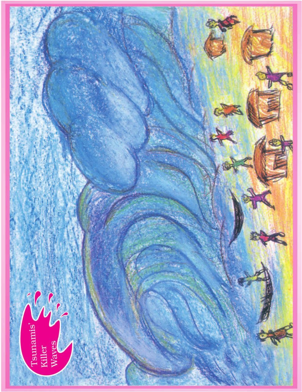
8 Two groups of islands also form part of India. Lakshadweep Islands are located in the Arabian Sea. These are coral islands located off the coast of Kerala. The Andaman and the Nicobar Islands lie to the southeast of the Indian mainland in the Bay of Bengal. Do you know which group of islands were affected by the Tsunami in 2004? Find out through newspaper reports and by speaking to people how in different ways people faced this challenge when Tsunami struck the Indian coast. Tsunami is a huge sea wave generated due to an earthquake on the sea floor. 1. Answer the following questions briefly. (a) (b) (c) (d) (e) (f) (g) Name the major physical divisions of India. India shares its land boundaries with seven countries. Name them. Which two major rivers fall into the Arabian Sea? Name the delta formed by the Ganga and the Brahmaputra. How many States and Union Territories are there in India? Which states have a common capital? Why do a large number of people live in the Northern plains? Why is Lakshadweep known as a coral island? 2. Tick the correct answers. (a) (b) (c) (d) The southernmost Himalayas are known as (i) Shiwaliks (ii) Himadri (iii) Himachal Sahyadris is also known as (i) Aravali (ii) Western Ghats (iii) Himadri The Palk Strait lies between the countries (i) Sri Lanka and Maldives (ii) India and Sri Lanka (iii) India and Maldives The Indian islands in the Arabian Sea are known as (i) Andaman and Nicobar Islands (ii) Lakshadweep Islands (iii) Maldives 54 THE EARTH : OUR HABITAT
9 (e) The oldest mountain range in India is the (i) Aravali hills (ii) Western ghats (iii) Himalayas 3. Fill in the blanks. (a) (b) (c) (d) (e) India has an area of about. The Greater Himalayas are also known as. The largest state in India in terms of area is. The river Narmada falls into the sea. The latitude that runs almost halfway through India is. Map skills 1. On an outline map of India, mark the following. (a) (b) (c) (d) (e) Tropic of Cancer Standard Meridian of India State in which you live Andaman Islands and Lakshadweep Islands Western Ghats and Eastern Ghats 55
SMART NOTES ON INDIAN GEOGRAPHY - 1
 ON INDIAN GEOGRAPHY - 1 Point. Precise. Powerful. www.thesmartnotes.org ON INDIAN GEOGRAPHY - 1 To our Hardworking and persistence aspirants. Success is going from failure to failure without losing enthusiasm.
Summative Assessment I
 Class: IV Time: 3 Hrs. Summative Assessment I Social Science Marks: 88 Handwriting: 2 Total: 90 1. All questions are compulsory. 2. Use crayons for colouring. General Instruction I. Multiple choice questions:
2. PHYSICAL FEATURES OF INDIA
 2. PHYSICAL FEATURES OF INDIA Question 1: Choose the right answer from the four alternatives given below. (i) A landmass bound by sea on three sides is referred to as (a) Coast (c) Peninsula (b) Island
INDIAN SCHOOL MUSCAT SENIOR SECTION DEPARTMENT OF SOCIAL SCIENCE CLASS: IX : GEOGRAPHY TOPIC/CHAPTER: CHAPTER: 2 PHYSICAL FEATURES
 INDIAN SCHOOL MUSCAT SENIOR SECTION DEPARTMENT OF SOCIAL SCIENCE CLASS: IX : GEOGRAPHY TOPIC/CHAPTER: CHAPTER: 2 PHYSICAL FEATURES WORKSHEET NO. 06 Summary:- Tectonic Plate Theory:- This theory is based
NCERT Class 9th Social Science Geography Chapter 2: Physical Features of India
 NCERT Class 9th Social Science Geography Chapter 2: Physical Features of India Question 1. Choose the right answer from the four alternatives given below. (i) A landmass bounded by sea on three sides in
India is a vast country with varied landforms. Our country has practically all major physical features of the earth i.e. mountains, plains, deserts,
 India is a vast country with varied landforms. Our country has practically all major physical features of the earth i.e. mountains, plains, deserts, plateaus and islands. India is a large landmass formed
Geography: Contemporary India - For Class IX Physical Features of India
 Geography: Contemporary India - For Class IX Physical Features of India (Q.1) Which are the two broad classification of peninsular plateau? (Q.2) What is a Doab? (Q.3) What is an Alluvial Plain. (Q.4)
SMART NOTES ON INDIAN GEOGRAPHY - 3
 ON INDIAN GEOGRAPHY - 3 Point. Precise. Powerful. www.thesmartnotes.org ON INDIAN GEOGRAPHY - 3 To our Hardworking and persistence aspirants. Success is going from failure to failure without losing enthusiasm.
15. THE GLOBE AND THE MAP
 15. THE GLOBE AND THE MAP 1 DEFINE THE FOLLOWING 1. AXIS : The imaginary line which passes through the centre of the earth and joins the North Pole and South Pole is called the Axis. The earth rotates
Downloaded from
 I II III IV V VI Define the following terms:- a) Orbitb) Meteoroids c) Celestial bodies GEOGRAPHY ASSIGNMENTS The Earth In The Solar System d) Satellite e) Comets Give one word answers:- a) Blue planet
Chapter 8 [Our World Continents and Oceans]
![Chapter 8 [Our World Continents and Oceans]](/thumbs/89/101173350.jpg "Chapter 8 [Our World Continents and Oceans]") 1 (iv) so. std. Multiple Choice Questions (MCQs) (for 2 nd Term) CLASS: IV SUBJECT: SOCIAL STUDIES Chapter 8 [Our World Continents and Oceans] 1. Earth is known as the planet. (a) red (b) blue (c) white
1 (iv) so. std. Multiple Choice Questions (MCQs) (for 2 nd Term) CLASS: IV SUBJECT: SOCIAL STUDIES Chapter 8 [Our World Continents and Oceans] 1. Earth is known as the planet. (a) red (b) blue (c) white
South, Southeast, and East Asia. Physical Geography
 South, Southeast, and East Asia Physical Geography Mountains v Mountains are important in Asia because they influence: A. Population patterns B. Movement of people and goods C. Climate Mountains v The
Geography and Economics
 Written as per the revised syllabus prescribed by the Maharashtra State Board of Secondary and Higher Secondary Education, Pune. Social Sciences Part II Geography and Economics Std. X Salient Features
Board Question Paper : March 2015
 Board Question Paper : March 2015 BOARD QUESTION PAPER : MARCH 2015 Time: 2 Hours Total Marks: 40 Note: i. All questions are compulsory. ii. Figure to the right indicate full marks. iii. Solve Q. No.3
DR.M.K.K ARYA MODEL SCHOOL
 DR.M.K.K ARYA MODEL SCHOOL Sub: Social science Syllabus Class-IV Session 2018-19 Prescribed book: Candid New Trends in Social Studies Syllabus to be completed in the month of April. Chapter 1.India Our
INDIA SIZE AND LOCATION
 QUESTION BANK IN SOCIAL SCIENCE CLASS-IX (TERM-I) 1 INDIA SIZE AND LOCATION Location CONCEPTS India lies entirely in the Northern Hemisphere. India s mainland extends between 8 4'N and 37 8'N latitudes,
UNIT 11 SOUTH ASIA SG 1 - PHYSICAL GEOGRAPHY & THE ENVIRONMENT
 UNIT 11 SOUTH ASIA SG 1 - PHYSICAL GEOGRAPHY & THE ENVIRONMENT I. PHYSICAL GEOGRAPHY TAKE OUT YOUR PHYSICAL MAP OF SOUTH ASIA A. The Himalayan Mountains form the northern boundary of the region (color
Sec$on 1: Geography and Early China. How does China s geography affect the culture?
 Sec$on 1: Geography and Early China How does China s geography affect the culture? Con$nents of the World Label the continents. Where is China located? Where is China located? In your groups, begin filling
India - Relief Features
 India - Relief Features CHAPTER 1 In this chapter we shall study about relief features of India. In the subsequent chapters such as Climate in India; Rivers and Water Resources; The People etc we would
Practice Question Paper-1 Class X - Geography Time - 2 Hours Total Marks - 40
 Practice Question Paper-1 Class X - Geography Time - 2 Hours Total Marks - 40 Note - 1) All questions are compulsory. 2) Draw neat diagrams/graphs wherever necessary. 3) Amswers should be written in blue
SPLIT UP OF SYLLABUS ( )
") April M Unit/Chapter 1.India - our country. 2. The Northern Mountains. Concepts/Sub topic *Neighboring countries and States of India. *Physical divisions of India. Learning Outcomes Mapping Skill: Identify
April M Unit/Chapter 1.India - our country. 2. The Northern Mountains. Concepts/Sub topic *Neighboring countries and States of India. *Physical divisions of India. Learning Outcomes Mapping Skill: Identify
Unit 1: Geography GeoTrekkers in the Western Hemisphere. Illustrated Glossary
 Unit 1: Geography GeoTrekkers in the Western Hemisphere Illustrated Glossary adapt to change in order to fit new condi/ons archipelago a group or chain of islands clustered together in a sea or ocean bodies
CHAPTER 1. Geo Challenges 1A to 1D. & World Map Activity
 CHAPTER 1 Geo Challenges 1A to 1D & World Map Activity SELECT YOUR CHALLENGE World Map Activity Challenge 1A Challenge 1B Challenge 1C Challenge 1D Challenge 1A WS PG. 2 STEP #1 Label the largest continent
BOARD OF SECONDARY EDUCATION (AP) SUMMATIVE ASSESSMENT - I TENTH SOCIAL MODEL PAPER PAPER - I (ENGLISH VERSION) SECTION - I
 SUMMATIVE ASSESSMENT - I TENTH SOCIAL MODEL PAPER PAPER - I (ENGLISH VERSION) SECTION - I") BOARD OF SECONDARY EDUCATION (AP) SUMMATIVE ASSESSMENT - I TENTH SOCIAL MODEL PAPER PAPER - I (ENGLISH VERSION) Time: 2 hrs. 45 mins. PART - A& B Maximum Marks: 40 Time: 2 hrs. 15 mins. PART - A Marks:
BOARD OF SECONDARY EDUCATION (AP) SUMMATIVE ASSESSMENT - I TENTH SOCIAL MODEL PAPER PAPER - I (ENGLISH VERSION) Time: 2 hrs. 45 mins. PART - A& B Maximum Marks: 40 Time: 2 hrs. 15 mins. PART - A Marks:
The United States & Canada. A Regional Study of Anglo America
 A Regional Study of Anglo America Landform Regions of the United States & Canada world leaders in agricultural and industrial production because of... VAST LANDS stretch from the Atlantic Ocean on the
About places and/or important events Landmarks Maps How the land is, hills or flat or mountain range Connected to maps World Different countries
 What do you think you know about geography? About places and/or important events Landmarks Maps How the land is, hills or flat or mountain range Connected to maps World Different countries What do you
MR. JOHNSON S. Geography OHIO COUNTY MIDDLE SCHOOL
 MR. JOHNSON S Geography OHIO COUNTY MIDDLE SCHOOL CHAPTER 1 Geography The science of geography is likely the oldest of all sciences. Geography is the answer to the question that the earliest humans asked,
Geography Class XI Fundamentals of Physical Geography Section A Total Periods : 140 Total Marks : 70. Periods Topic Subject Matter Geographical Skills
 Geography Class XI Fundamentals of Physical Geography Section A Total Periods : 140 Total Marks : 70 Sr. No. 01 Periods Topic Subject Matter Geographical Skills Nature and Scope Definition, nature, i)
Natural Vegetation and Wildlife
 Natural Vegetation and Wildlife Exercise Page 51 Question 1: Choose the right answer from the four alternatives given below. (i) To which one of the following types of vegetation does rubber belong? (a)
INDIAN SCHOOL MUSCAT SENIOR SECTION DEPARTMENT OF SOCIAL SCIENCE CLASS: IX - GEOGRAPHY CHAPTER:3 : DRAINAGE WORKSHEET NO. 09
 INDIAN SCHOOL MUSCAT SENIOR SECTION DEPARTMENT OF SOCIAL SCIENCE CLASS: IX - GEOGRAPHY CHAPTER: : DRAINAGE WORKSHEET NO. 09 Please write following question-answers in your note book: 2,4,, 8, 9, 12,18,
The Indian Ocean. Copyright 2010 LessonSnips
 The Indian Ocean One of the five major geographic divisions of the world s ocean, the Indian Ocean is located in the Eastern Hemisphere. The Indian Ocean is bounded by three continents: Africa to the west,
Unit 1: Basics of Geography Test Review
 Name Date Period Unit 1: Basics of Geography Test Review Directions: Reading the following sections and complete the questions, charts, and diagrams. Types of Maps Maps that have a particular theme are
N. K. Manglik Director
 N. K. Manglik Director Hydro-meteorological observations could be broadly defined as the scientific way for collection of flow data at a specific location along the river including selected meteorological
Unit 1: Geography. For additional information, refer to this website: 1 G e o g r a p h y
 Unit 1: Geography For additional information, refer to this website: http://mryoungtms.weebly.com/ 1 G e o g r a p h y Continents and Oceans SOL USI. 2a Essential Understanding: Continents are large land
3. HYDROMETEROLOGY. 3.1 Introduction. 3.2 Hydro-meteorological Aspect. 3.3 Rain Gauge Stations
 3. HYDROMETEROLOGY 3.1 Introduction Hydrometeorology is a branch of meteorology and hydrology that studies the transfer of water and energy between the land surface and the lower atmosphere. Detailed hydrological
September 14, 2013 Objective: How does geography impact history? What important features exist that have shaped societies?
 Lowenhaupt 1 September 14, 2013 Objective: How does geography impact history? What important features exist that have shaped societies? Warm-Up: In your binder, answer the following question: Imagine you
ALL INDIA WEATHER SUMMARY AND FORECAST BULLETIN
 Sunday 22 April 2018 NIGHT Time of Issue: 2000 hours IST ALL INDIA WEATHER SUMMARY AND FORECAST BULLETIN Significant Weather Features The ongoing fairly widespread rainfall activity with isolated thunder
EQ: Discuss main geographic landforms of the U.S. & Canada and examine varied landforms in relation to their lifestyles.
 EQ: Discuss main geographic landforms of the U.S. & Canada and examine varied landforms in relation to their lifestyles. Places & Terms for Discussion Appalachian Mountains Great Plains Canadian Shield
Complete Geography Overview: Year 1 to Year 6
 Option 1 Complete Geography Overview: Year 1 to Year 6 Autumn Term Spring Term Summer Term Year 1 Where do I live? Around the World The Four Seasons Year 2 At the Farm Let s go on Safari My World and Me
ORLD G EOGRAPHY BASIC. NotB oring. Inventive Exercises to Sharpen Skills and Raise Achievement. Imogene Forte & Marjorie Frank
 The BASIC NotB oring SERIES SOCIAL IP 402-0 STUDIES SKILLS MIDDLE GRADES ORLD G EOGRAPHY Inventive Exercises to Sharpen Skills and Raise Achievement Series Concept & Development by Imogene Forte & Marjorie
BOARD OF SECONDARY EDUCATION (AP) SUMMATIVE ASSESSMENT - I TENTH CLASS SOCIAL STUDIES MODEL PAPER PAPER - I (ENGLISH VERSION)
 SUMMATIVE ASSESSMENT - I TENTH CLASS SOCIAL STUDIES MODEL PAPER PAPER - I (ENGLISH VERSION)") BOARD OF SECONDARY EDUCATION (AP) SUMMATIVE ASSESSMENT - I TENTH CLASS SOCIAL STUDIES MODEL PAPER PAPER - I (ENGLISH VERSION) Time: 2 hrs. 45 mins. PART - A & B Maximum Marks: 40 INSTRUCTIONS: i) 15 minutes
BOARD OF SECONDARY EDUCATION (AP) SUMMATIVE ASSESSMENT - I TENTH CLASS SOCIAL STUDIES MODEL PAPER PAPER - I (ENGLISH VERSION) Time: 2 hrs. 45 mins. PART - A & B Maximum Marks: 40 INSTRUCTIONS: i) 15 minutes
Physical Geography. Ariel view of the Amazon Rainforest. A Look at the Seven Continents
 Physical Geography In this unit you will learn about general physical geography. The study of the Earth s surface features provides the setting for the human-environmental interactions and for the human
Social Science Class 9 th DRAINAGE Drainage System In India Himalayan River System Peninsular River System Lakes Role of Rivers in the Economy
 Social Science Class 9 th DRAINAGE Drainage System In India Himalayan River System Peninsular River System Lakes Role of Rivers in the Economy The term drainage describes the river system of an area. The
2 Georgia: Its Heritage and Its Promise
 TERMS region, erosion, fault, elevation, Fall Line, aquifer, marsh, climate, weather, precipitation, drought, tornado, hurricane, wetland, estuary, barrier island, swamp PLACES Appalachian Mountains, Appalachian
BOARD OF SECONDARY EDUCATION (TELANGANA) SUMMATIVE ASSESSMENT - I TENTH CLASS SOCIAL STUDIES MODEL PAPER
 SUMMATIVE ASSESSMENT - I TENTH CLASS SOCIAL STUDIES MODEL PAPER") BOARD OF SECONDARY EDUCATION (TELANGANA) SUMMATIVE ASSESSMENT - I TENTH CLASS SOCIAL STUDIES MODEL PAPER PAPER - I (ENGLISH VERSION) Time: 2 hrs. 45 mins. PART - A& B Maximum Marks: 40 INSTRUCTIONS: i)
BOARD OF SECONDARY EDUCATION (TELANGANA) SUMMATIVE ASSESSMENT - I TENTH CLASS SOCIAL STUDIES MODEL PAPER PAPER - I (ENGLISH VERSION) Time: 2 hrs. 45 mins. PART - A& B Maximum Marks: 40 INSTRUCTIONS: i)
netw rks Guided Reading Activity Essential Question: How does geography influence the way people live? Earth's Physical Geography
 Guided Reading Activity Lesson 1 Earth and the Sun Essential Question: How does geography influence the way people live? Looking at Earth Directions: What are the layers that make up Earth? Use your textbook
Geography Long Term Plan. Autumn Spring Summer
 Geography Long Term Plan Autumn Spring Summer Year 1 Working Scientifically covered throughout the year Location Geography of UK Name, locate and identify characteristics of the four countries and capital
2008 SIVECO Romania. All Rights Reserved. Geography. AeL econtent Catalogue
 2008 SIVECO Romania. All Rights Reserved. Geography AeL econtent Catalogue The Earth's Movements Recommended for two hours of teaching. AeL Code: 352. 2. The Earth Rotation Movement in 24 hours 3. The
Chapter 21 Southwest Asia: Harsh & Arid Lands
 Name Hour Chapter 21 Southwest Asia: Harsh & Arid Lands Essential Question: How has the physical geography of Asia influenced the development of these regions (i.e. history, population distribution, &
Name Date Class. a. High elevation and high relief b. High elevation and level surface c. Flat land and low relief
 Exploring Earth s Surface (pp. 21 27) This section describes factors that determine the shape of Earth s land surface. The section also describes how scientists divide Earth into four spheres. Use Target
Year 1 name and locate the four countries and capital cities of the United Kingdom and its surrounding seas
 Long Term Objective Organisation for Geography Please note that only statutory requirements should be included in this document; any supplementary guidance and information should be retained by Subject
Neighbouring Countries of India, States and Union Territories of India, Physical Division of India
 CLASS: SUBJECT : PRESCRIBED BOOKS : IV SOCIAL SCIENCE ANNUAL SYLLABUS -2016-17 SYLLABUS TOPIC PRESCRIBED BOOK CHAPTER NAME TOPIC Social Science L-1 India- Our Country Neighbouring Countries of India, States
4th Grade Social Studies First Nine Weeks
 4th Grade Social Studies First Nine Weeks Multiple Choice Identify the choice that best completes the statement or answers the question. 1 Name the mountains that are located in the eastern United States.
The structure of the Earth and how its motion creates the seasons. The landforms of the earth and the forces that shape the land.
 The structure of the Earth and how its motion creates the seasons. The landforms of the earth and the forces that shape the land. The role of wind and water in creating climate. The different climate and
Dr. M.K.K. Arya Model School Class-V, Social Science Assignment Ch-1, Globe The Model of the Earth Answer the following:- Q.1.
 Class-V, Social Science Assignment Ch-1, Globe The Model of the Earth - Q.1. What are the disadvantages/demerits of a globe? Ans. Some disadvantages of globe are: a) It is difficult to carry. b) It cannot
Map Skills Unit. Note taking unit
 Map Skills Unit Note taking unit Introduction To learn about the Earth, we are going to learn about two geographic tools you can use.globes and maps. Globe A globe is a round model of the planet Earth
CLASS VI GEOGRAPHY FORTNIGHTLY SYLLABUS NEW SESSION 2 ND APRIL Sub Topic. Introduction- The different celestial bodies.
 CLASS VI GEOGRAPHY FORTNIGHTLY SYLLABUS 08-09 NEW SESSION ND APRIL 08 S. No Fortnight Days Main Topic. nd April 3 th April Chapter The Earth in the Solar system Sub Topic - The different celestial bodies
SBOA. SCHOOLAND JUNIOR COLLEGE, CHENNAI 101 ASSIGNMENT (GEOGRAPHY & ECONOMICS)
") SBOA. SCHOOLAND JUNIOR COLLEGE, CHENNAI 101 STD: IX ASSIGNMENT (GEOGRAPHY & ECONOMICS) GEOGRAPHY 1. INDIA SIZE AND LOCATION 1. Name the group of islands lying in the Arabian Sea and Bay of Bengal. 2. Name
SBOA. SCHOOLAND JUNIOR COLLEGE, CHENNAI 101 STD: IX ASSIGNMENT (GEOGRAPHY & ECONOMICS) GEOGRAPHY 1. INDIA SIZE AND LOCATION 1. Name the group of islands lying in the Arabian Sea and Bay of Bengal. 2. Name
GEOGRAPHY Practice Answer Paper - 2
 GEOGRAPHY Practice Answer Paper - 2 Q.1) Select the correct option and rewrite the sentence : 4 1) According to Census 2011, the average population density of India is 382 persons per sq.km. 2) The rate
ALL INDIA WEATHER SUMMARY AND FORECAST BULLETIN
 Saturday 21 April 2018 MORNING Time of Issue: 0800 hours IST ALL INDIA WEATHER SUMMARY AND FORECAST BULLETIN Significant Weather Features Isolated thunder squalls and hailstorms are very likely over Sub
(version 3) I. HumAN -Environment Interaction
 I. HumAN -Environment Interaction") (version 3) I. HumAN -Environment Interaction A. Landforms 1. Earth s topography is made up of many different types of landforms. 2. While the planet is covered primarily with water, the four major types
(version 3) I. HumAN -Environment Interaction A. Landforms 1. Earth s topography is made up of many different types of landforms. 2. While the planet is covered primarily with water, the four major types
New National Curriculum Geography Skills Planning KS1
 New National Curriculum Geography Skills Planning KS1 Enquiry Question Objective-essential knowledge skills or understanding Locational Knowledge Standards /Success Criteria Lesson progression over half
Regional Atlas Activity C
 Political Location Activity AUSTRALIA, OCEANIA, AND ANTARCTICA Regional Atlas Activity C DIRECTIONS: Identify each country marked by a number on the map. Then write the correct name on the numbered blanks
Major Domain of the Earth
 Major Domain of the Earth The surface of the earth is a complex zone in which three main components of the environment meet, overlap and interact. The solid portion of the earth on which we live is called
Physical Geography of East Asia
 Physical Geography of East Asia Satellite View of China Landforms of China China s Geography China Miles 0 250 500 1,000 1,500 2,000 United States 3 rd largest country in the world. Comparable to the US
Geography Progression
 Geography Progression This document aims to track expectations for History within George Grenville Academy. What the National Curriculum says: KS1: Locational Knowledge: Name and locate the world s 7 continents
Geography Mile Post 1
 Mile Post 1 Use world maps, atlases and globes to identify the UK and its countries, as well as the countries, continents and oceans studied at this key stage Key Skills IPC learning Goals 1.11 Be able
GEOGRAPHY. Map Skills. Mrs. Pere ~ 2013
 GEOGRAPHY Map Skills Mrs. Pere ~ 2013 WHAT IS A GLOBE? A globe is a model of the Earth. North Pole Equator South Pole WHAT IS A MAP? A map is a flat drawing of a place. THE IMPORTANT PARTS OF A MAP 1.
Geographical location and climatic condition of the
 Geographical location and climatic condition of the study sites North eastern region of India is comprised of eight states namely; Arunachal Pradesh, Assam, Manipur, Meghalaya, Mizoram, Nagaland, Sikkim
What is the largest country in the world? Russia
 What is the largest country in the world? #1 Russia CSCOPE 2007 2 Russia Dimensions #2-3 Spans 11 Time Zones From East to West: Gulf of Finland to Alaska From North to South: Above the Arctic Circle to
Earth s Layers. Earth s Surface
 CHAPTER 1 LESSON 3 Earth s Layers Earth s Surface Key Concepts What are Earth s major landforms and how do they compare? What are the major landform regions of the United States? What do you think? Read
What Is a Globe? Hemispheres. Main Idea Globes and maps provide different ways of showing features of the earth. Terms to Know
 r Main Idea Globes and maps provide different ways of showing features of the earth. Terms to Know hemisphere latitude longitude scale bar scale relief elevation contour line What Is a Globe? A globe is
ALL INDIA WEATHER SUMMARY AND FORECAST BULLETIN
 Tuesday 08 May 2018 MID DAY Time of Issue: 1345 hours IST ALL INDIA WEATHER SUMMARY AND FORECAST BULLETIN Significant Weather Features Under the influence of the present Western Disturbance over Jammu
INTERNATIONAL INDIAN SCHOOL, RIYADH HALF YEARLY
 INTERNATIONAL INDIAN SCHOOL, RIYADH HALF YEARLY 2018-19 STD V Fill in the blanks: WORKSHEET LESSON - 1 KNOW YOUR PLANET SOCIAL STUDIES 1 A book containing maps is called an _ 2 A Flemish map maker, collection
CLASS VI SOCIAL STUDIES LEARNING OBJECTIVES. To recall students about planets, satellite & other celestial bodies.
 CLASS VI SOCIAL STUDIES MONTH CHAPTER LEARNING OBJECTIVES LIFE SKILLS ACTIVITY AND ASSIGNMENTS Apr-May Ch-1 The Planet Earth and the Solar System To recall students about planets, satellite & other celestial
What landforms make up Australia?!
 What landforms make up Australia? The tectonic forces of folding, faulting and volcanic activity have created many of Australia's major landforms. Other forces that work on the surface of Australia, and
Chapter 1 Section 2. Land, Water, and Climate
 Chapter 1 Section 2 Land, Water, and Climate Vocabulary 1. Landforms- natural features of the Earth s land surface 2. Elevation- height above sea level 3. Relief- changes in height 4. Core- most inner
discussion of North America s physical features, including its landforms and bodies of
 Chapter 7 Natural Environments of North America Chapter 7 focuses on the natural environments of North America. The chapter opens with a discussion of North America s physical features, including its landforms
Long Range Forecast Update for 2014 Southwest Monsoon Rainfall
 Earth System Science Organization (ESSO) Ministry of Earth Sciences (MoES) India Meteorological Department PRESS RELEASE New Delhi, 9 June 2014 Long Update for 2014 Southwest Monsoon Rainfall HIGHLIGHTS
Chapter 1: The Geography of the Western Hemisphere
 Chapter 1: The Geography of the Western Hemisphere Chapter 1, Lesson 1: The Changing Earth Objectives: - You will be able to identify the major natural events that cause the earth to change. - You will
Exploring Geography. Chapter 1
 Exploring Geography Chapter 1 The Study of Geography Geography is the study of where people, places, and things are located and how they relate to each other. Greek meaning writing about or describing
CHAPTER 12 NATURAL DISASTERS
 CHAPTER 12 NATURAL DISASTERS In this chapter, you learn about the following: Natural calamities cyclones causes, effects and preventive measures Floods causes, affected areas, effects and control Land
Witchampton CofE First School Geography Curriculum Map
 2016-2017 Autumn People and : 30-50 Show interest in the lives of people who are familiar to them. Shows interest in different occupations. Remembers and talks significant events in their own experience.
4th Grade US Regional Geography First Nine Weeks
 4th Grade US Regional Geography First Nine Weeks 2014-2015 Identify the choice that best completes the statement or answers the question. 1 The line identified as 0 runs west and east on the globe and
Understanding Projections
 GEOGRAPHY SKILLS 1 Understanding Projections The earth is a sphere and is best shown as a globe. For books and posters, though, the earth has to be represented as a flat object. To do this, mapmakers create
Geography Long Term Plan 2018
 Geography Long Term Plan 2018 Geography Co-ordinator: Megan Frost A high-quality geography education should inspire in pupils a curiosity and fascination about the world and its people that will remain
Tuition, Medical and Behaviour Support Service
 Tuition, Medical and Behaviour Support Service Curriculum Policy - Primary Geography Reviewed: October 2018 Next Review: October 2019 Responsibility: Andrea Snow AIMS AND PRINCIPLES The national curriculum
1. Match the words in the first column to the meaning in the second column. [5]
![1. Match the words in the first column to the meaning in the second column. [5]](/thumbs/96/126839765.jpg "1. Match the words in the first column to the meaning in the second column. [5]") Exercise 1: [40 POINTS] 1. Match the words in the first column to the meaning in the second column. [5] Equator Around earth between the Equator and the Poles. Greenwich meridian Half of earth. Longitude
Exercise 1: [40 POINTS] 1. Match the words in the first column to the meaning in the second column. [5] Equator Around earth between the Equator and the Poles. Greenwich meridian Half of earth. Longitude
By- Saurabh Pandey Junior research fellow(jrf) NET, MA, B.TECH 3 Years teaching experience UPSC Faculty
 NET, MA, B.TECH 3 Years teaching experience UPSC Faculty") Important Topics (Mapping) By- Saurabh Pandey Junior research fellow(jrf) NET, MA, B.TECH 3 Years teaching experience UPSC Faculty Topic 1 - PALESTINE AND ISRAEL west asia Q Which of the following countries
Important Topics (Mapping) By- Saurabh Pandey Junior research fellow(jrf) NET, MA, B.TECH 3 Years teaching experience UPSC Faculty Topic 1 - PALESTINE AND ISRAEL west asia Q Which of the following countries
Downloaded from
 BAL BHARATI PUBLIC SCHOOL, PITAMPURA, DELHI GEOGRAPHY CLASS IX CHAPTER -3 DRAINAGE (summative assessment 1) Q.1. What is a River System? Ans. A river along with its tributaries is known as a River System
Developed in Consultation with Florida Educators
 Developed in Consultation with Florida Educators Table of Contents Next Generation Sunshine State Standards Correlation Chart... 7 Benchmarks Chapter 1 The Practice of Science...................... 11
You have already learnt earlier that India
 2 PHYSICAL FEATURES OF INDIA You have already learnt earlier that India is a vast country with varied landforms. What kind of terrain do you live in? If you live in the plains you are familiar with the
By Geri Flanary To accompany AP Human Geography: A Study Guide 3 rd edition By Ethel Wood
 Session 1 By Geri Flanary To accompany AP Human Geography: A Study Guide 3 rd edition By Ethel Wood WHAT IS DEMOGRAPHY? It is the scientific or statistical study of population. It comes from the Greek
Mount Everest and the Gobi Desert
 Mount Everest and the Gobi Desert 1 Mount Everest is part of the mountain chain known as the Himalaya. Adventurers from all over the world come to try to climb it. Mount Everest is the highest mountain
Figure 2.1: Constituent Area
 2 The Region 2.1 CONSTITUENT AREA The National Capital Region includes NCT-Delhi, nine districts of Haryana, six districts of Uttar Pradesh and one district of Rajasthan. Total area of the region is 34,144
ALL INDIA INSTALLED CAPACITY (IN MW) OF POWER STATIONS
 OF POWER STATIONS") Region Northern Region Western Region Southern Region Eastern Region North Eastern Region Islands ALL INDIA Figures at decimal may not tally due to rounding off ALL INDIA INSTALLED CAPACITY (IN MW) OF
Region Northern Region Western Region Southern Region Eastern Region North Eastern Region Islands ALL INDIA Figures at decimal may not tally due to rounding off ALL INDIA INSTALLED CAPACITY (IN MW) OF
The Geography Curriculum at Coston Primary
 The Geography Curriculum at Coston Primary Years Year 1 Year 2 Summer We are learning about where food is farmed and in The physical features of farms. The human features of farms. The characteristics
California: Land and People Lesson 1: Locating California
 California: Land and People Lesson 1: Locating California Hemisphere One half of the earth or another sphere Video on Hemispheres click here Relative location Where a place is compared to one or more other
Cranford Park CE Primary School. Subject Overview for Geography. Autumn 1 Autumn 2 Spring 1 Spring 2 Summer 1 Summer 2 Title of unit.
 Autumn 1 Autumn 2 Spring 1 Spring 2 Summer 1 Summer 2 Main Objectives /Skills Main Objectives /Skills Main Objectives /Skills Main Objectives /Skills Main Objectives /Skills Main Objectives /Skills Foundation
Map Skills and Geographic Tools
 Name: Period: Map Skills and Geographic Tools TEKS: 8.9C interpret topographic maps and satellite views to identify land and erosional features and predict how these features may be reshaped by weathering