India is a vast country with varied landforms. Our country has practically all major physical features of the earth i.e. mountains, plains, deserts,
|
|
|
- May Harris
- 5 years ago
- Views:
Transcription
1
2


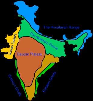
3 India is a vast country with varied landforms. Our country has practically all major physical features of the earth i.e. mountains, plains, deserts, plateaus and islands. India is a large landmass formed during different geological periods which has influenced her relief. Besides geological formations, a number of processes such as weathering, erosion and deposition have created and modified the relief its present form.
4 CAUSES OF PLATE MOVEMENT Plates at our planet s surface move because of the intense heat in the Earth s core that causes molten rock in the mantle layer to move. It moves in a pattern called a onvection cell that forms when warm material rises, cools, and eventually sink down. As the cooled material sinks down, it is warmed and rises again. The movement of the plates results in the building up of stresses within the plates and the continental rocks above, leading to folding, faulting and volcanic activity.

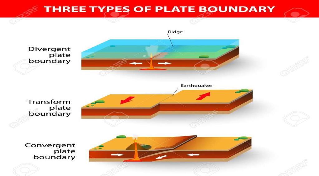
5 Tectonic Plate Theory:- The tectonic plate theory describes the large scale motion of the earth s lithosphere. This theory is based on continental drift which explains the formation of various continents over millions of years Plate Boundaries:- Based on the relative movement between two tectonic plates, there are three types of plate boundaries.

6 They are as follows: Transform Boundary: In this case, the two adjacent plates move along their borders. Convergent Boundary: In this case, the two adjacent tectonic plates move towards each other. Divergent Boundary: In this case, the two adjacent plates move away from each other.
7

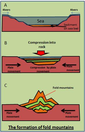
8 There are many hypothesis regarding the origin of Himalaya, however there is almost a complete unanimity that the Himalayan mountains have come out of a great geosyncline called the Tethys Sea. About 120 million years ago, there were only two big continents in the world- in the north was Laurasia or Angaraland and in the southern hemisphere was Gondwanaland. In between Laurasia and Gondwanaland, there was a long, narrow and shallow sea called Tethys Sea. Sediments were brought by the rivers from these landmasses and deposited in the bed of the sea. These sediments were subjected to the powerful compression force from both the continents, this compression squeezed and crushed the sediments of Tethys and series of folds were formed one behind the other giving rise to the highest relief features on the earth - the Himalayas. The curved shape of the Himalayas convex to the south, is attributed to the maximum push offered at two ends of the Indian peninsula during its northward drift. In the northwest it was done by the Aravalis and in the northeast by the Assam Ranges. Recent studies shows that India is moving northward at the rate of about 5 cm per year and crashing into rest of the Asia, buckling the Himalayas between Angaraland and Gondwanaland. This drift is providing instability to the Himalayan region.
9
10


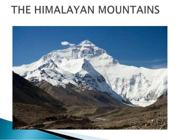
11 The Himalayas are the youngest mountains in the world and are; structurally; the folded mountains. The Himalayas run along the northern border of India. The Himalayas form an arc which is about 2,400 km long. The width varies from 400 km in Kashmir to 150 km in Arunachal Pradesh. The altitudinal variations are greater in the eastern part than in the western part. There are three parallel ranges in its longitudinal extent.
12

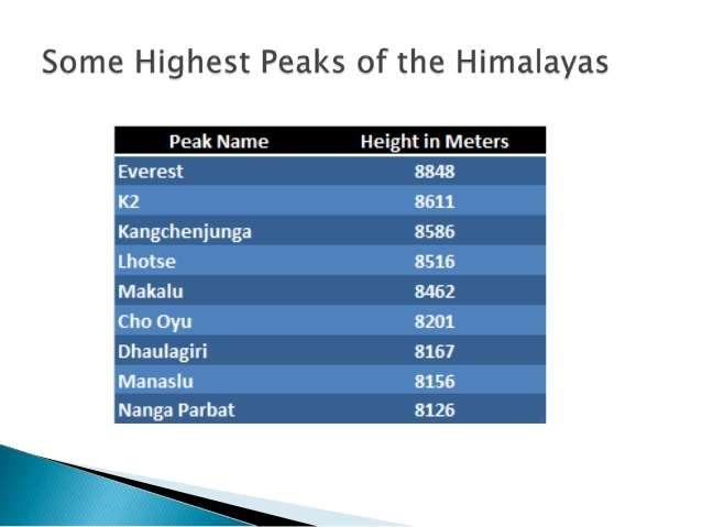
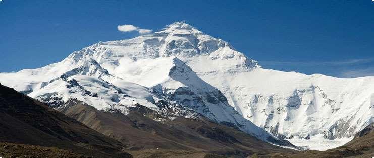
13 (1) The Great or Inner Himalayas:- This is the northernmost range and is also known as Himadri. This is the most continuous range. It contains the loftiest peaks. The average height of peaks in this range is 6,000 meters. All the prominent Himalayan peaks are in this range. The folds of the Great Himalayas are asymmetrical in nature and the core of this part is composed of granite. Because of the lofty heights, the peaks of this range are perennially snow-bound. (2) The Lesser Himalaya or Himachal: This lies towards the south of the Great Himalayas. The altitude of peaks in this range varies from 3,700 m to 4,500 m. Average width of this range is 50 km. This range is mainly composed of highly compressed and altered rocks. (3) The Shiwaliks:- This is the outermost range of the Himalayas. The altitude varies between 900 and 1100 km in this range and the width varies between 10 to 50 km. These ranges are composed of unconsolidated sediments. The longitudinal valleys lying between the Himachal and Shiwaliks are called Dun.

14 Himalayan Regions from East to West: Punjab Himalayas:- This part lies between the Indus and Sutlej. From west to east, this is also known as Kashmir Himalaya and Himachal Himalaya; respectively. Kumaon Himalayas: This part lies between Sutlej and Kali rivers. Nepal Himalayas: This part lies between the Kali and Tista rivers. Assam Himalayas: This part lies between the Tista and Dihang rivers. Eastern hills and mountains: The Brahmaputra marks the eastern border of the Himalayas. Beyond the Dihang gorge, the Himalayas bend sharply towards south and form the Eastern hills or Purvachal. These hills run through the north eastern states of India. They are mostly composed of sandstones. These hills are composed of the Patkai Hills, Naga Hills, Manipuri Hills and Mizo Hills.
15
16


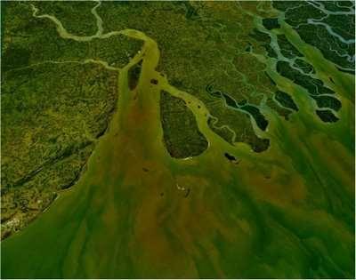
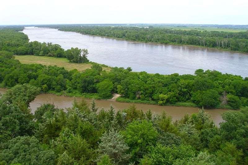
17 The Northern Plain The northern plain of India is formed by three river systems, viz. the Indus, the Ganga and the Brahmaputra; along with their tributaries. This plain is composed of alluvial soil which has been deposited over millions of years. The total area of the northern plain is about 7 lakh square kilometer. It is about 2400 km long and about 240 to 320 km broad
18 The northern plain is divided into three sections, viz. the Punjab Plain, the Ganga Plain and the Brahmaputra Plain. Punjab Plains: The Punjab plains form the western part of the northern plain. This is formed by the Indus and its tributaries; like Jhelum, Chenab, Ravi, Beas and Sutlej. A major portion of this plains is in Pakistan. Doabs abound in this plain. Ganga Plains: This plain extends between Ghaggar and Tista rivers. The northern states, Haryana, Delhi, UP, Bihar, part of Jharkhand and West Bengal lie in the Ganga plains. Brahmaputra Plains: This plain forms the eastern part of the northern plain and lies in Assam.

19 Based on the relief features; the northern plain can be divided into four regions, viz. bhabar, terai, bhangar and khadar. Bhabar: After descending from the mountains, the rivers deposit pebbles in a narrow belt. The width of this belt is about 8 to 16 km and it lies parallel to the Shiwaliks. This region is known as bhabar. All the streams disappear in this region. Terai: The terai region lies towards south of the bhabar belt. In this region, the streams reappear and make a wet, swampy and marshy region. Bhangar: Bhangar is the largest part of the northern plain and is composed of the oldest alluvial soil. They lie above the flood plains. They resemble terraces. The soil of this region is locally known as kanka and is composed of calcareous deposits. Khadar: The floodplains formed by younger alluvium are called khadar. The soil in this region is renewed every year and is thus highly fertile.


20 THE NORTHERN PLAINS OF INDIA
21
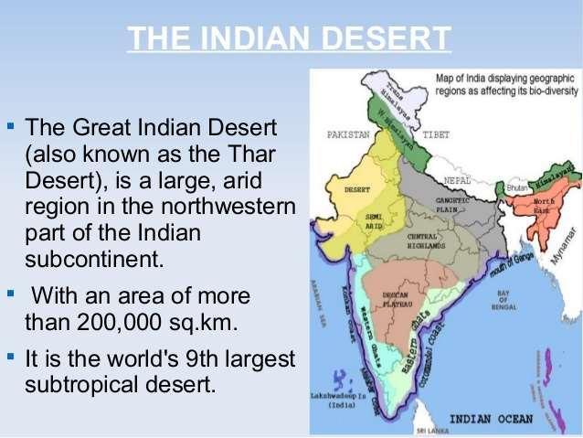
22


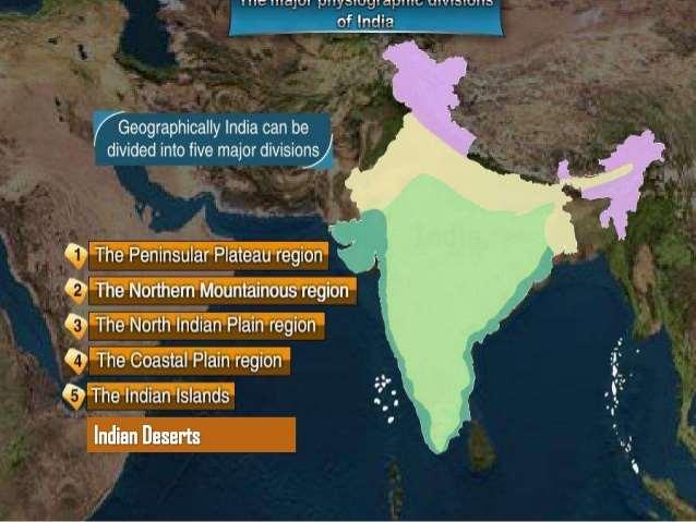
23 The Peninsular Plateau The peninsular plateau is a tableland. It is composed of the oldest rocks because it was formed from the drifted part of the Gondwana land. Broad and shallow valleys and rounded hills are the characteristic features of this plateau.

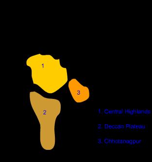
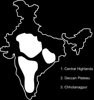
24 The plateau can be broadly divided into two regions, viz. the Central Highlands and the Deccan Plateau. The Central Highlands: The Central Highlands lies to the north of the Narmada river. It covers the major portion of the Malwa plateau. The rivers in this region flow from southwest to northeast; which indicates the slope of this region. It is wider in the west and narrower in the east. Bundelkhand and Baghelkhand mark the eastward extension of this plateau. The plateau further extends eastwards into the Chhotanagpur plateau. The Deccan Plateau:- The Deccan Plateau lies to the south of the Naramada river. It is triangular in shape. The Satpura range makes its northern part. The Mahadev, Kaimur Hills and Maikal range make its eastern part. The slope of the Deccan Plateau is from west to east. It extends into the north east which encompasses Meghalaya, Karbi-Anglong Plateau and North Cachar Hills. Garo, Khasi and Jaintia hills are the prominent ranges; starting from west to east.


25 The Western and the Eastern Ghats:- They make the western and eastern edges of the Deccan Plateau. The average elevation of Western Ghats is metres; compared to 600 metres in case of Eastern Ghats. The Eastern Ghats stretch from Mahanadi Valley to the Nilgiris in the south. The Western Ghats cause oceanographic rains as they face the rain-laden winds from west.
26

27 THE THAR DESERT
28

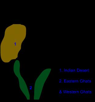
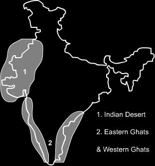
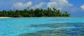
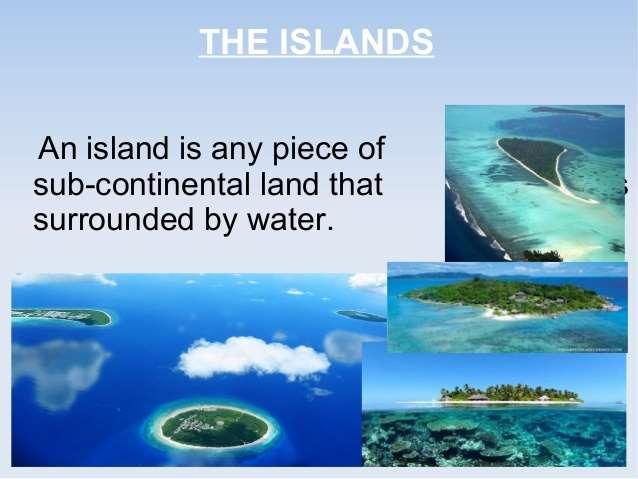
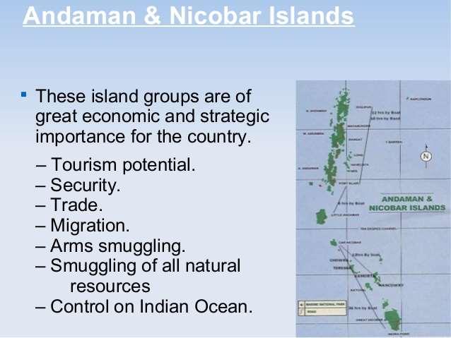
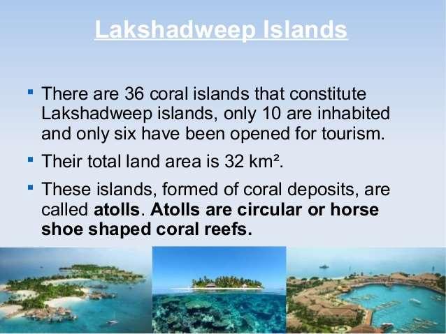
29 The Indian Desert:- The Indian desert lies towards the western margins of the Aravali Hills. This region gets scanty rainfall which is less than 150 mm in a year. Hence they climate is arid and vegetation is scanty. Luni is the only large river but some streams appear during rainy season. Crescent-shaped dunes (barchans) abound in this area.
30
31

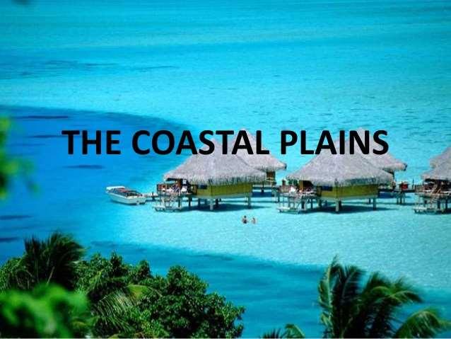
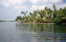
32 The Coastal Plains The Peninsular plateau is flanked by stretch of narrow coastal strips. They run along the Arabian Sea on the west and along the Bay of Bengal on the east. The western coast lies between the Western Ghats and the Arabian Sea. It is divided into three sections. The Konkan; which comprises of Mumbai and Goa makes the northern part. The Kannada Plain makes the central pat and the Malabar coast makes the Malabara coast. The western coastal plain is wider and level and it runs along the Bay of Bengal. It is divided into two parts. The northern part is called Northern Circar. The southern part is called the Coromandel Coast. Extensive deltas are formed by large rivers like Mahanadi, Godavari and Kavery. Chilika lake is an important feature along the eastern coast

33 THE COASTAL PLAINS

34
35
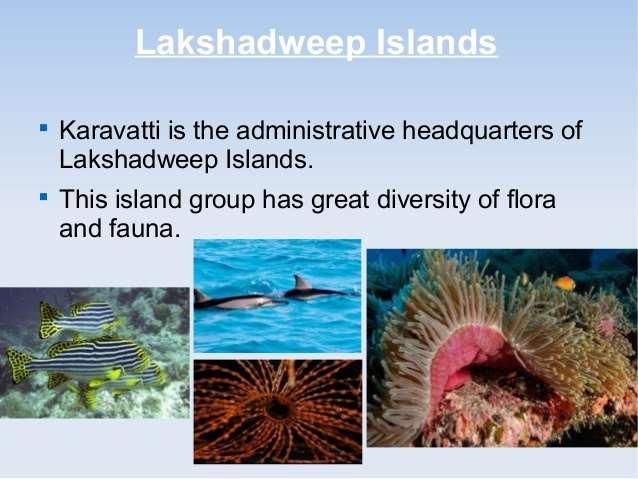
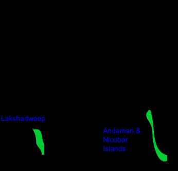
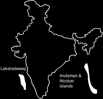
36 The Islands The Lakshadweep Islands are in the Arabian Sea. Its area is 32 sq km. The administrative headquarters of Lakshadweep is at Kavaratti island. This group of islands is rich in terms of biodiversity. The Andaman and Nicobar Islands are bigger in size and has more number of islands. This group of islands can be divided into two groups. The Andaman is in the north and the Nicobar is in the south. These islands too have rich biodiversity.
37
38
39

40


41 MADE BY- NAME-INDRANI MONDAL CLASS-09 ROLL No.-04
2. PHYSICAL FEATURES OF INDIA
 2. PHYSICAL FEATURES OF INDIA Question 1: Choose the right answer from the four alternatives given below. (i) A landmass bound by sea on three sides is referred to as (a) Coast (c) Peninsula (b) Island
INDIAN SCHOOL MUSCAT SENIOR SECTION DEPARTMENT OF SOCIAL SCIENCE CLASS: IX : GEOGRAPHY TOPIC/CHAPTER: CHAPTER: 2 PHYSICAL FEATURES
 INDIAN SCHOOL MUSCAT SENIOR SECTION DEPARTMENT OF SOCIAL SCIENCE CLASS: IX : GEOGRAPHY TOPIC/CHAPTER: CHAPTER: 2 PHYSICAL FEATURES WORKSHEET NO. 06 Summary:- Tectonic Plate Theory:- This theory is based
NCERT Class 9th Social Science Geography Chapter 2: Physical Features of India
 NCERT Class 9th Social Science Geography Chapter 2: Physical Features of India Question 1. Choose the right answer from the four alternatives given below. (i) A landmass bounded by sea on three sides in
Geography: Contemporary India - For Class IX Physical Features of India
 Geography: Contemporary India - For Class IX Physical Features of India (Q.1) Which are the two broad classification of peninsular plateau? (Q.2) What is a Doab? (Q.3) What is an Alluvial Plain. (Q.4)
You have already learnt earlier that India
 2 PHYSICAL FEATURES OF INDIA You have already learnt earlier that India is a vast country with varied landforms. What kind of terrain do you live in? If you live in the plains you are familiar with the
OUR COUNTRY INDIA LOCATIONAL SETTING
 7 India is a country of vast geographical expanse. In the north, it is bound by the lofty Himalayas. The Arabian Sea in the west, the Bay of Bengal in the east and the Indian Ocean in the south, wash the
SMART NOTES ON INDIAN GEOGRAPHY - 3
 ON INDIAN GEOGRAPHY - 3 Point. Precise. Powerful. www.thesmartnotes.org ON INDIAN GEOGRAPHY - 3 To our Hardworking and persistence aspirants. Success is going from failure to failure without losing enthusiasm.
India - Relief Features
 India - Relief Features CHAPTER 1 In this chapter we shall study about relief features of India. In the subsequent chapters such as Climate in India; Rivers and Water Resources; The People etc we would
Summative Assessment I
 Class: IV Time: 3 Hrs. Summative Assessment I Social Science Marks: 88 Handwriting: 2 Total: 90 1. All questions are compulsory. 2. Use crayons for colouring. General Instruction I. Multiple choice questions:
PHYSICAL FEATURES OF SOUTH ASIA
 PHYSICAL FEATURES OF SOUTH ASIA Formation India is a land of varied physical features. The physical features of India have evolved over several geological periods. According to the theory of Plate Tectonics
SMART NOTES ON INDIAN GEOGRAPHY - 1
 ON INDIAN GEOGRAPHY - 1 Point. Precise. Powerful. www.thesmartnotes.org ON INDIAN GEOGRAPHY - 1 To our Hardworking and persistence aspirants. Success is going from failure to failure without losing enthusiasm.
ITL Public School GEOGRAPHY Ch -1: India -Size and Location Class IX
 ITL Public School GEOGRAPHY Ch -1: India -Size and Location Class IX INDIA KNOWN AS A SUB CONTINENT: India and the adjoining countries are considered to be a sub-continent as it comprises of all the characteristics
TERM I UNIT II GEOGRAPHY CLASS IX Prepared by NARAYANAN MANNANDI. The Indian School Bahrain
 TERM I UNIT II GEOGRAPHY CLASS IX 2013-14 14 Prepared by NARAYANAN MANNANDI The Indian School Bahrain Ch 1 - INDIA SIZE AND LOCATION 1) Describe the size and location of India. Location:- i) India is a
Chapter 8 [Our World Continents and Oceans]
![Chapter 8 [Our World Continents and Oceans]](/thumbs/89/101173350.jpg "Chapter 8 [Our World Continents and Oceans]") 1 (iv) so. std. Multiple Choice Questions (MCQs) (for 2 nd Term) CLASS: IV SUBJECT: SOCIAL STUDIES Chapter 8 [Our World Continents and Oceans] 1. Earth is known as the planet. (a) red (b) blue (c) white
1 (iv) so. std. Multiple Choice Questions (MCQs) (for 2 nd Term) CLASS: IV SUBJECT: SOCIAL STUDIES Chapter 8 [Our World Continents and Oceans] 1. Earth is known as the planet. (a) red (b) blue (c) white
Natural Vegetation and Wildlife
 Natural Vegetation and Wildlife Exercise Page 51 Question 1: Choose the right answer from the four alternatives given below. (i) To which one of the following types of vegetation does rubber belong? (a)
deep within the planet. They are also shaped by conditions on the planet s surface. In
 Chapter 4 Landforms, Water, and Natural Resources Earth is home to many different types of landforms. These landforms are shaped by forces deep within the planet. They are also shaped by conditions on
Board Question Paper : March 2015
 Board Question Paper : March 2015 BOARD QUESTION PAPER : MARCH 2015 Time: 2 Hours Total Marks: 40 Note: i. All questions are compulsory. ii. Figure to the right indicate full marks. iii. Solve Q. No.3
Landscape evolution. An Anthropic landscape is the landscape modified by humans for their activities and life
 Landforms Landscape evolution A Natural landscape is the original landscape that exists before it is acted upon by human culture. An Anthropic landscape is the landscape modified by humans for their activities
Plate Tectonics. Structure of the Earth
 Plate Tectonics Structure of the Earth The Earth can be considered as being made up of a series of concentric spheres, each made up of materials that differ in terms of composition and mechanical properties.
DR.M.K.K ARYA MODEL SCHOOL
 DR.M.K.K ARYA MODEL SCHOOL Sub: Social science Syllabus Class-IV Session 2018-19 Prescribed book: Candid New Trends in Social Studies Syllabus to be completed in the month of April. Chapter 1.India Our
Chapter 1 Section 2. Land, Water, and Climate
 Chapter 1 Section 2 Land, Water, and Climate Vocabulary 1. Landforms- natural features of the Earth s land surface 2. Elevation- height above sea level 3. Relief- changes in height 4. Core- most inner
UNIT 11 SOUTH ASIA SG 1 - PHYSICAL GEOGRAPHY & THE ENVIRONMENT
 UNIT 11 SOUTH ASIA SG 1 - PHYSICAL GEOGRAPHY & THE ENVIRONMENT I. PHYSICAL GEOGRAPHY TAKE OUT YOUR PHYSICAL MAP OF SOUTH ASIA A. The Himalayan Mountains form the northern boundary of the region (color
Chapter Two. Figure 02_02. Geography of the Ocean Basins. The Sea Floor
 Chapter Two The Sea Floor Geography of the Ocean Basins Figure 02_02 The world ocean is the predominant feature on the Earth in total area. In the Northern Hemisphere, 61% of the total area is ocean. In
Mount Everest and the Gobi Desert
 Mount Everest and the Gobi Desert 1 Mount Everest is part of the mountain chain known as the Himalaya. Adventurers from all over the world come to try to climb it. Mount Everest is the highest mountain
WHAT IS THE EARTH MADE OF? LITHOSPHERE AND HYDROSPHERE
 UNIT 8 WHAT IS THE EARTH MADE OF? LITHOSPHERE AND HYDROSPHERE TABLE OF CONTENTS 1 THE STRUCTURE OF THE EARTH... 2 2 THE FORMATION OF THE RELIEF: INTERNAL AND EXTERNAL FORCES.... 2 2.1 Internal forces:
3. HYDROMETEROLOGY. 3.1 Introduction. 3.2 Hydro-meteorological Aspect. 3.3 Rain Gauge Stations
 3. HYDROMETEROLOGY 3.1 Introduction Hydrometeorology is a branch of meteorology and hydrology that studies the transfer of water and energy between the land surface and the lower atmosphere. Detailed hydrological
Chapter 02 The Sea Floor
 Chapter 02 The Sea Floor Multiple Choice Questions 1. One of the following is not one of the world's major ocean basins: A. Atlantic Ocean B. Arctic Ocean C. Indian Ocean D. Antarctic Ocean E. Pacific
BOARD OF SECONDARY EDUCATION (AP) SUMMATIVE ASSESSMENT - I TENTH SOCIAL MODEL PAPER PAPER - I (ENGLISH VERSION) SECTION - I
 SUMMATIVE ASSESSMENT - I TENTH SOCIAL MODEL PAPER PAPER - I (ENGLISH VERSION) SECTION - I") BOARD OF SECONDARY EDUCATION (AP) SUMMATIVE ASSESSMENT - I TENTH SOCIAL MODEL PAPER PAPER - I (ENGLISH VERSION) Time: 2 hrs. 45 mins. PART - A& B Maximum Marks: 40 Time: 2 hrs. 15 mins. PART - A Marks:
BOARD OF SECONDARY EDUCATION (AP) SUMMATIVE ASSESSMENT - I TENTH SOCIAL MODEL PAPER PAPER - I (ENGLISH VERSION) Time: 2 hrs. 45 mins. PART - A& B Maximum Marks: 40 Time: 2 hrs. 15 mins. PART - A Marks:
Geography and Economics
 Written as per the revised syllabus prescribed by the Maharashtra State Board of Secondary and Higher Secondary Education, Pune. Social Sciences Part II Geography and Economics Std. X Salient Features
Social Science Class 9 th DRAINAGE Drainage System In India Himalayan River System Peninsular River System Lakes Role of Rivers in the Economy
 Social Science Class 9 th DRAINAGE Drainage System In India Himalayan River System Peninsular River System Lakes Role of Rivers in the Economy The term drainage describes the river system of an area. The
What landforms make up Australia?!
 What landforms make up Australia? The tectonic forces of folding, faulting and volcanic activity have created many of Australia's major landforms. Other forces that work on the surface of Australia, and
INDIAN SCHOOL MUSCAT SENIOR SECTION DEPARTMENT OF SOCIAL SCIENCE CLASS: IX - GEOGRAPHY CHAPTER:3 : DRAINAGE WORKSHEET NO. 09
 INDIAN SCHOOL MUSCAT SENIOR SECTION DEPARTMENT OF SOCIAL SCIENCE CLASS: IX - GEOGRAPHY CHAPTER: : DRAINAGE WORKSHEET NO. 09 Please write following question-answers in your note book: 2,4,, 8, 9, 12,18,
BOARD OF SECONDARY EDUCATION (AP) SUMMATIVE ASSESSMENT - I TENTH CLASS SOCIAL STUDIES MODEL PAPER PAPER - I (ENGLISH VERSION)
 SUMMATIVE ASSESSMENT - I TENTH CLASS SOCIAL STUDIES MODEL PAPER PAPER - I (ENGLISH VERSION)") BOARD OF SECONDARY EDUCATION (AP) SUMMATIVE ASSESSMENT - I TENTH CLASS SOCIAL STUDIES MODEL PAPER PAPER - I (ENGLISH VERSION) Time: 2 hrs. 45 mins. PART - A & B Maximum Marks: 40 INSTRUCTIONS: i) 15 minutes
BOARD OF SECONDARY EDUCATION (AP) SUMMATIVE ASSESSMENT - I TENTH CLASS SOCIAL STUDIES MODEL PAPER PAPER - I (ENGLISH VERSION) Time: 2 hrs. 45 mins. PART - A & B Maximum Marks: 40 INSTRUCTIONS: i) 15 minutes
THE EARTH S RELIEF SOCIAL SCIENCES 1º ESO
 THE EARTH S RELIEF SOCIAL SCIENCES 1º ESO 1. THE STRUCTURE OF THE EARTH The Earth is divided into layers: The crust is the surface layer. It is a thin, solid layer made of rock. The Earth s crust has a
South, Southeast, and East Asia. Physical Geography
 South, Southeast, and East Asia Physical Geography Mountains v Mountains are important in Asia because they influence: A. Population patterns B. Movement of people and goods C. Climate Mountains v The
Copyright McGraw-Hill Education. All rights reserved. No reproduction or distribution without the prior written consent of McGraw-Hill Education
 Copyright McGraw-Hill Education. All rights reserved. No reproduction or distribution without the prior written consent of McGraw-Hill Education Tibetan Plateau and Himalaya -southern Asia 11.00.a VE 10X
The Sea Floor. Chapter 2
 The Sea Floor Chapter 2 Geography of the Ocean Basins World ocean is the predominant feature on the Earth in total area Northern Hemisphere = 61% of the total area is ocean. Southern Hemisphere = about
PALEOGEOGRAPHY of NYS. Definitions GEOLOGIC PROCESSES. Faulting. Folding 9/6/2012. TOPOGRAPHIC RELIEF MAP of NYS GRADATIONAL TECTONIC
 TOPOGRAPHIC RELIEF MAP of NYS PALEOGEOGRAPHY of NYS Prof. Anthony Grande AFG 2012 Definitions GEOLOGIC PROCESSES Geography: study of people living on the surface of the earth. Geology: the scientific study
Landforms in Canada. Canada is made up of three dis;nct types of landforms: Canadian Shield Highlands Lowlands
 Canada s Landforms What is a Landform? A landform is any physical feature of the Earth s surface having a characteris;c, recognizable shape, produced by natural causes. Landforms include major features
ISSUED BY KENDRIYA VIDYALAYA - DOWNLOADED FROM
 UNIT II CHAPTER -2 PHYSIOGRAPHY - INDIA PHYSIOGRAPHY Structure and Relief; physiographic divisions Drainage systems: concept of water sheds the Himalayan and the Peninsular Can you map different phases
Developed in Consultation with Florida Educators
 Developed in Consultation with Florida Educators Table of Contents Next Generation Sunshine State Standards Correlation Chart... 7 Benchmarks Chapter 1 The Practice of Science...................... 11
The structure of the Earth and how its motion creates the seasons. The landforms of the earth and the forces that shape the land.
 The structure of the Earth and how its motion creates the seasons. The landforms of the earth and the forces that shape the land. The role of wind and water in creating climate. The different climate and
Name. 4. The diagram below shows a soil profile formed in an area of granite bedrock. Four different soil horizons, A, B, C, and D, are shown.
 Name 1. In the cross section of the hill shown below, which rock units are probably most resistant to weathering? 4. The diagram below shows a soil profile formed in an area of granite bedrock. Four different
Terrain Units PALEOGEOGRAPHY: LANDFORM CREATION. Present Geology of NYS. Detailed Geologic Map of NYS
 NYS TOPOGRAPHY Why so? PALEOGEOGRAPHY: LANDFORM CREATION Prof. Anthony Grande AFG 014 Present Geology of NYS Detailed Geologic Map of NYS Generalized Geology Detailed Geology Hot links to the fold out
Physical Geography A Living Planet
 Physical Geography A Living Planet The geography and structure of the earth are continually being changed by internal forces, like plate tectonics, and external forces, like the weather. Iguaçu Falls at
Geography Class XI Fundamentals of Physical Geography Section A Total Periods : 140 Total Marks : 70. Periods Topic Subject Matter Geographical Skills
 Geography Class XI Fundamentals of Physical Geography Section A Total Periods : 140 Total Marks : 70 Sr. No. 01 Periods Topic Subject Matter Geographical Skills Nature and Scope Definition, nature, i)
Continental Drift and Plate Tectonics
 Continental Drift and Plate Tectonics Continental Drift Wegener s continental drift hypothesis stated that the continents had once been joined to form a single supercontinent. Wegener proposed that the
15. THE GLOBE AND THE MAP
 15. THE GLOBE AND THE MAP 1 DEFINE THE FOLLOWING 1. AXIS : The imaginary line which passes through the centre of the earth and joins the North Pole and South Pole is called the Axis. The earth rotates
water erosion lithosphere Describe the process of erosion and deposition. chemical weathering Dissolving limestone is an example of.
 At one time, there was one large island off the coast of Mississippi and now it is two separate islands. What caused the island to be split into two? water erosion The crust and the top part of the upper
Grade 9 Social Studies Canadian Identity. Chapter 2 Review Canada s Physical Landscape
 Grade 9 Social Studies Canadian Identity Chapter 2 Review Canada s Physical Landscape Name: Unit 1: Empowerment Terms (notes or textbook) 1. Core 2. Crust 3. Mantle 4. Magma 5. Continental drift 6. Plate
Chapter 6, Part Colonizers arriving in North America found extremely landscapes. It looked different to region showing great.
 Social Studies 9 Unit 1 Worksheet Chapter 6, Part 1. 1. Colonizers arriving in North America found extremely landscapes. It looked different to region showing great. 2. The Earth is years old and is composed
I. Earth s Layers a. Crust: Earth s outside layer. Made of mostly rock. i. Continental: er; made of mostly granite, forms the continents and shallow
 I. Earth s Layers a. Crust: Earth s outside layer. Made of mostly rock. i. Continental: er; made of mostly granite, forms the continents and shallow sea beds, floats! ii. Oceanic: er; dense rock such as
Chapter 2 Planet Earth
 Chapter 2 Planet Earth Section Notes Earth and the Sun s Energy Water on Earth The Land Close-up The Water Cycle World Almanac Major Eruptions in the Ring of Fire Quick Facts Chapter 2 Visual Summary Video
Geographical location and climatic condition of the
 Geographical location and climatic condition of the study sites North eastern region of India is comprised of eight states namely; Arunachal Pradesh, Assam, Manipur, Meghalaya, Mizoram, Nagaland, Sikkim
A physical feature of the Earth s surface
 Earth s Landforms A physical feature of the Earth s surface A physical feature of the Earth s surface LANDFORM Highest of Earth s physical features Highest of Earth s physical features MOUNTAIN Low area
Figure 2.1: Constituent Area
 2 The Region 2.1 CONSTITUENT AREA The National Capital Region includes NCT-Delhi, nine districts of Haryana, six districts of Uttar Pradesh and one district of Rajasthan. Total area of the region is 34,144
Social Studies 9 UNIT 2 GEOGRAPHIC INFLUENCES ON IDENTITY: PLACE AND PEOPLE
 Social Studies 9 UNIT 2 GEOGRAPHIC INFLUENCES ON IDENTITY: PLACE AND PEOPLE The Structure of the Earth To understand the forces that create Canada's physical landscape we must understand the structure
Earth Movement and Resultant Landforms
 Earth Movement and Resultant Landforms Structure of the Earth Lithosphere : earth s crust Asthenosphere : upper mantle zone where material is near its melting point & acts almost like liquid (appprox.
Downloaded from
 I II III IV V VI Define the following terms:- a) Orbitb) Meteoroids c) Celestial bodies GEOGRAPHY ASSIGNMENTS The Earth In The Solar System d) Satellite e) Comets Give one word answers:- a) Blue planet
ALL INDIA WEATHER SUMMARY AND FORECAST BULLETIN
 Sunday 22 April 2018 NIGHT Time of Issue: 2000 hours IST ALL INDIA WEATHER SUMMARY AND FORECAST BULLETIN Significant Weather Features The ongoing fairly widespread rainfall activity with isolated thunder
netw rks Guided Reading Activity Essential Question: How does geography influence the way people live? Earth's Physical Geography
 Guided Reading Activity Lesson 1 Earth and the Sun Essential Question: How does geography influence the way people live? Looking at Earth Directions: What are the layers that make up Earth? Use your textbook
USU 1360 TECTONICS / PROCESSES
 USU 1360 TECTONICS / PROCESSES Observe the world map and each enlargement Pacific Northwest Tibet South America Japan 03.00.a1 South Atlantic Arabian Peninsula Observe features near the Pacific Northwest
 Page 1 of 9 Name: Base your answer to the question on the diagram below. The arrows show the direction in which sediment is being transported along the shoreline. A barrier beach has formed, creating a
(version 3) I. HumAN -Environment Interaction
 I. HumAN -Environment Interaction") (version 3) I. HumAN -Environment Interaction A. Landforms 1. Earth s topography is made up of many different types of landforms. 2. While the planet is covered primarily with water, the four major types
(version 3) I. HumAN -Environment Interaction A. Landforms 1. Earth s topography is made up of many different types of landforms. 2. While the planet is covered primarily with water, the four major types
Unit 4 Lesson 2 Plate Tectonics. Copyright Houghton Mifflin Harcourt Publishing Company
 Puzzling Evidence What evidence suggests that continents move? In the late 1800s, Alfred Wegener proposed his hypothesis of continental drift. According to this hypothesis, the continents once formed a
Prentice Hall EARTH SCIENCE
 Prentice Hall EARTH SCIENCE Tarbuck Lutgens Chapter 9 Plate Tectonics 9.1 Continental Drift An Idea Before Its Time Wegener s continental drift hypothesis stated that the continents had once been joined
Prentice Hall EARTH SCIENCE
 Prentice Hall EARTH SCIENCE Tarbuck Lutgens Chapter 9 Plate Tectonics 9.1 Continental Drift An Idea Before Its Time Wegener s continental drift hypothesis stated that the continents had once been joined
A Living Planet. Chapter PHYSICAL GEOGRAPHY. What you will learn in this chapter. Summary of the chapter
 QUIT Main Ideas What you will learn in this chapter Summary Summary of the chapter Test your geographic knowledge by playing the. Main Ideas Section 1: The Earth Inside and Out The earth is the only habitable
World Geography Chapter 3
 World Geography Chapter 3 Section 1 A. Introduction a. Weather b. Climate c. Both weather and climate are influenced by i. direct sunlight. ii. iii. iv. the features of the earth s surface. B. The Greenhouse
The United States & Canada. A Regional Study of Anglo America
 A Regional Study of Anglo America Landform Regions of the United States & Canada world leaders in agricultural and industrial production because of... VAST LANDS stretch from the Atlantic Ocean on the
YORK CASTLE HIGH SCHOOL CHRISTMAS TERM EXAMINATIONS GEOGRAPHY Duration 1 1 /2 HRS.
 GRADE 9 YORK CASTLE HIGH SCHOOL CHRISTMAS TERM EXAMINATIONS GEOGRAPHY Duration 1 1 /2 HRS. Name: 1. Label the internal structure of the earth provided below. WRITE on the space provide. Oceanic Crust/Upper
Section 2: How Mountains Form
 Section 2: How Mountains Form Preview Objectives Mountain Ranges and Systems Plate Tectonics and Mountains Types of Mountains Objectives Identify the types of plate collisions that form mountains. Identify
Section 3 Deforming Earth s Crust
 Section 3 Deforming Earth s Crust Key Concept Tectonic plate motions deform Earth s crust. Deformation causes rock layers to bend and break and causes mountains to form. What You Will Learn Stress is placed
Exploring Geography. Chapter 1
 Exploring Geography Chapter 1 The Study of Geography Geography is the study of where people, places, and things are located and how they relate to each other. Greek meaning writing about or describing
Earth s Layers. Earth s Surface
 CHAPTER 1 LESSON 3 Earth s Layers Earth s Surface Key Concepts What are Earth s major landforms and how do they compare? What are the major landform regions of the United States? What do you think? Read
ALL INDIA WEATHER SUMMARY AND FORECAST BULLETIN
 Saturday 21 April 2018 MORNING Time of Issue: 0800 hours IST ALL INDIA WEATHER SUMMARY AND FORECAST BULLETIN Significant Weather Features Isolated thunder squalls and hailstorms are very likely over Sub
Directed Reading. Section: How Mountains Form MOUNTAIN RANGES AND SYSTEMS. Skills Worksheet
 Skills Worksheet Directed Reading Section: How Mountains Form 1. How high is Mount Everest? a. about 1980 km above sea level b. more than 8 km below sea level c. more than 8 km above sea level d. more
LANDFORMS. Extra Credit. Name Date
 LANDFORMS Extra Credit Name Date 1. Label the drawing above using the words below that match the landforms. canyon meander plateau delta mountain valley 2. The bending of rock at plate boundaries is A.
Chapter 2: Physical Geography
 Chapter 2: Physical Geography Pg. 39-68 Learning Goals for Chp2: q q q q q Explain how the Earth moves in space and why seasons change. Outline the factors that influence climate and recognize different
Week: 4 5 Dates: 9/8 9/12 Unit: Plate Tectonics
 clementaged.weebly.com Name: ODD Period: Week: 4 5 Dates: 9/8 9/12 Unit: Plate Tectonics Monday Tuesday Wednesday Thursday Friday 7 No School 8 E 9 O *Vocabulary *Frayer Vocab *Continental Drift Notes
1- Water on Earth 2- Oceans and seas / continental waters 3- Uses, risks and problems of water
 Contents: I- Relief 1- Structure of the Earth and relief formation 2- Shaping of relief 3- Types of relief II- Water 1- Water on Earth 2- Oceans and seas / continental waters 3- Uses, risks and problems
A) B) C) D) 4. Which diagram below best represents the pattern of magnetic orientation in the seafloor on the west (left) side of the ocean ridge?
 B) C) D) 4. Which diagram below best represents the pattern of magnetic orientation in the seafloor on the west (left) side of the ocean ridge?") 1. Crustal formation, which may cause the widening of an ocean, is most likely occurring at the boundary between the A) African Plate and the Eurasian Plate B) Pacific Plate and the Philippine Plate C)
1. Crustal formation, which may cause the widening of an ocean, is most likely occurring at the boundary between the A) African Plate and the Eurasian Plate B) Pacific Plate and the Philippine Plate C)
Continental Landscapes
 Continental Landscapes Landscape influenced by tectonics, climate & differential weathering Most landforms developed within the last 2 million years System moves toward an equilibrium Continental Landscapes
Continental Drift. & Plate Tectonics
 Continental Drift & Plate Tectonics Alfred Wegener, a German scientist, proposed the hypothesis of CONTINENTAL DRIFT, in 1912. Hypothesis stated: All Earth s continents were once a single landmass (Pangaea)
Refer to the map on page 173 to answer the following questions.
 Chapter 8-1 Plate Tectonics 1. Brainstorm the type of evidence that would indicate a climate change and how this evidence supports the theory of continental drift. Tropical fossils in cold regions Evidence
Chapter 1: The Geography of the Western Hemisphere
 Chapter 1: The Geography of the Western Hemisphere Chapter 1, Lesson 1: The Changing Earth Objectives: - You will be able to identify the major natural events that cause the earth to change. - You will
Unit 1: Geography. For additional information, refer to this website: 1 G e o g r a p h y
 Unit 1: Geography For additional information, refer to this website: http://mryoungtms.weebly.com/ 1 G e o g r a p h y Continents and Oceans SOL USI. 2a Essential Understanding: Continents are large land
discussion of North America s physical features, including its landforms and bodies of
 Chapter 7 Natural Environments of North America Chapter 7 focuses on the natural environments of North America. The chapter opens with a discussion of North America s physical features, including its landforms
ALL INDIA WEATHER SUMMARY AND FORECAST BULLETIN
 Tuesday 08 May 2018 MID DAY Time of Issue: 1345 hours IST ALL INDIA WEATHER SUMMARY AND FORECAST BULLETIN Significant Weather Features Under the influence of the present Western Disturbance over Jammu
Directed Reading. Section: Continental Drift. years ago? WEGENER S HYPOTHESIS
 Skills Worksheet Directed Reading Section: Continental Drift 1. Who obtained new information about the continents and their coastlines 400 years ago? 2. What did people notice when they studied new world
Earth Systems, Structures and Processes
 Earth Systems, Structures and Processes Date: 6.E.2 Understand the structure of the earth and how interactions of constructive and destructive forces have resulted in changes in the surface of the Earth
Chapter 21 Southwest Asia: Harsh & Arid Lands
 Name Hour Chapter 21 Southwest Asia: Harsh & Arid Lands Essential Question: How has the physical geography of Asia influenced the development of these regions (i.e. history, population distribution, &
The Ocean Floor Chapter 14. Essentials of Geology, 8e. Stan Hatfield and Ken Pinzke Southwestern Illinois College
 The Ocean Floor Chapter 14 Essentials of Geology, 8e Stan Hatfield and Ken Pinzke Southwestern Illinois College The vast world ocean Earth is often referred to as the water planet 71% of Earth s surface
Constructive and Destructive Forces. Processes That Act Upon Earth s Surface Features
 Constructive and Destructive Forces Processes That Act Upon Earth s Surface Features What are Constructive and Destructive Forces? Constructive Force A constructive force is a process that raises or builds
2 Georgia: Its Heritage and Its Promise
 TERMS region, erosion, fault, elevation, Fall Line, aquifer, marsh, climate, weather, precipitation, drought, tornado, hurricane, wetland, estuary, barrier island, swamp PLACES Appalachian Mountains, Appalachian
UNIT 3 GEOLOGY VOCABULARY FLASHCARDS THESE KEY VOCABULARY WORDS AND PHRASES APPEAR ON THE UNIT 3 CBA
 UNIT 3 GEOLOGY VOCABULARY FLASHCARDS THESE KEY VOCABULARY WORDS AND PHRASES APPEAR ON THE UNIT 3 CBA A map that shows Earth s Topographic Map surface topography, which is Earth s shape and features Contour
Plate Tectonics Unit II: Plate Boundaries (3.5 pts)
") T. James Noyes, El Camino College Plate Tectonics Unit II: The Plate Boundaries (Topic 11A-2) page 1 Name: Section: Plate Tectonics Unit II: Plate Boundaries (3.5 pts) Plate Boundaries We will now discuss
T. James Noyes, El Camino College Plate Tectonics Unit II: The Plate Boundaries (Topic 11A-2) page 1 Name: Section: Plate Tectonics Unit II: Plate Boundaries (3.5 pts) Plate Boundaries We will now discuss
Part 1: Weather Forecast Severe Weather Warnings (Source: IMD, Date: 1 st September, 2008)
") Sphere India Unified Response Strategy Situation report (India Floods 2008) 01 st September 2008 Part 1: Weather Forecast Severe Weather Warnings (Source: IMD, Date: 1 st September, 2008) HEAVY RAINFALL
Sphere India Unified Response Strategy Situation report (India Floods 2008) 01 st September 2008 Part 1: Weather Forecast Severe Weather Warnings (Source: IMD, Date: 1 st September, 2008) HEAVY RAINFALL
INTRODUCTION. Climate
 INTRODUCTION Climate Landslides are serious natural disasters in many parts of the world. Since the past 30 years, rainfall triggered landslides and debris flows had been one of the natural disasters of
Chapter 2 Earth s Interlocking Systems pg The Earth and Its Forces pg
 Chapter 2 Earth s Interlocking Systems pg. 24 55 2 1 The Earth and Its Forces pg. 27 33 Connecting to Your World and Internal Forces Shaping the Earth The Earth is unique in the solar system because it