INTRODUCTION. Climate
|
|
|
- Harry Johnson
- 5 years ago
- Views:
Transcription

1

2 INTRODUCTION Climate Landslides are serious natural disasters in many parts of the world. Since the past 30 years, rainfall triggered landslides and debris flows had been one of the natural disasters of the country. The best estimate of direct and indirect costs of landslide damage range between million baht.
 the eastern coasts of low mountain range and coastal deposit. 3) the northeastern part; the high plateau of sandstone, siltstone and shale.")
3 INTRODUCTION Geology of Thailand 5 main geomorphology areas of Thailand are; 1) the central plain; the large alluvial flood plain and colluvium fans on mountain foots. 2) the eastern coasts of low mountain range and coastal deposit. 3) the northeastern part; the high plateau of sandstone, siltstone and shale. 4) the northern and western continental highlands, the high mountain ranges formed by granitic rocks, metamorphic rocks, and old alluvium in the valley. 5) the southern part; the granitic mountain ranges on the west side combined with old and young sedimentation on the central and east sides of the peninsular.
")
4 INTRODUCTION During the last 30 years, the landslide cases were fairly well recorded. Landslide events in Thailand (GERD, 2006)


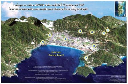
5 STUDY AREA High potential of landslide due to its geographic and geologic condition. High consequences for tourist After tsunami, developer tend to disturb the stable slope in the upper level


6 STUDY AREA This table shows some event of landslide records gathered by Patong municipality, it shows that most of the landslide has triggered by excessive rainfall.


7 Kalim Village Na Nai Village Landslide Events on October,

8 GEOLOGICAL CHARACTERISTICS Geological characteristics of Patong include formation of granite in Cretaceous Era and modern beach sediments in Quaternary period. Granite rock is found to be in moderately to highly weathered condition with various sets of joint and fracture. Left lateral strike-slip fault has found mostly with their strike lies between north-east to south-west direction.

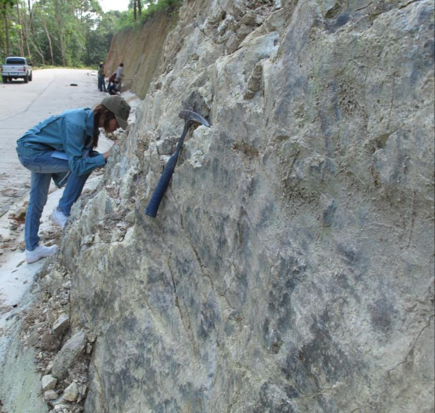
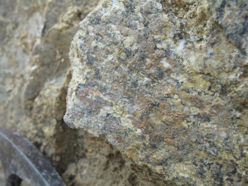

9 GEOLOGICAL CHARACTERISTICS


10 LANDSLIDE SUSCEPTIBILITY MAP The landslide hazard area is determined using weighing factor method. Factor of safety against sliding and slope angle relationship is calculated based on shear strength data. Other factors are also considered after extensive review of the latest literatures and after acquired more information in the target area. In determining the numerical rating for landslide potential of each 6 parameters, an area of 25 square meters grid cell has been employed for the analysis by GIS program. The weight-rating value of each parameter is determined in each square grid cell of each derivative map. Suttisuk et al., 2010

11 LANDSLIDE SUSCEPTIBILITY MAP The results of the analysis are shown in Figure. It clearly that the actual events are matched with the moderate to high landslide susceptibility area from the result of analysis with the matching of 78.2 percent. Suttisuk et al., 2010

12 Early Warning & Evacuation Action Critical Rainfall
13 Hazard Mapping and Evacuation planning Main road Hotel 2. Official place 3. Nanai village and hospital 4. Resorts and Spa 5. Temple 6. Police Station

14 Hazard Mapping and Evacuation planning Main road EOC EOC 1 Shelter 1. Hotel 2. Official place 3. Nanai village and hospital 4. Resorts and Spa 5. Temple 6. Police Station
15 CONCLUSIONS 1. Landslide Mapping is necessary to understand the factors that affect the occurrence of landslides. In the case of this study. Slope and the fault is a major factor landslides in the area. 2. The disasters in the past and the cause of the disaster, as well as rainfall is very important to analyze the management of landslide hazards. 3. The near real time landslide warning required extensive type of data such as the geotechnical properties of residual soil, geologic conditions and the rainfall data. 4. However, the field monitoring shall be performed to verify the analysis before the public warning can be issued.

16
EIT-Japan Symposium 2011 on Human Security Engineering
 EIT-Japan Symposium 2011 on Human Security Engineering 2011 Disastrous Landslides at Khao Panom, Krabi, Thailand Suttisak Soralump Geotechnical Engineering Research and Development Center (GERD) Faculty
2014 Summer Training Courses on Slope Land Disaster Reduction Hydrotech Research Institute, National Taiwan University, Taiwan August 04-15, 2014
 Final Project Report 2014 Summer Training Courses on Slope Land Disaster Reduction Hydrotech Research Institute, National Taiwan University, Taiwan August 04-15, 2014 Landslides in Mt. Umyeon Susceptibility
International Journal of Modern Trends in Engineering and Research e-issn No.: , Date: April, 2016
 International Journal of Modern Trends in Engineering and Research www.ijmter.com e-issn No.:2349-9745, Date: 28-30 April, 2016 Landslide Hazard Management Maps for Settlements in Yelwandi River Basin,
Debris flow: categories, characteristics, hazard assessment, mitigation measures. Hariklia D. SKILODIMOU, George D. BATHRELLOS
 Debris flow: categories, characteristics, hazard assessment, mitigation measures Hariklia D. SKILODIMOU, George D. BATHRELLOS Natural hazards: physical phenomena, active in geological time capable of producing
A Roundup of Recent Debris Flow Events in Taiwan
 2015 International Workshop on Typhoon and Flood APEC Experience Sharing on Hazardous Weather Events and Risk Management A Roundup of Recent Debris Flow Events in Taiwan Hsiao-Yuan(Samuel) Yin Ph.D. sammya@mail.swcb.gov.tw
Landslide analysis to estimate probability occurrence of earthquakes by software ArcGIS in central of Iran
 Research Journal of Recent Sciences ISSN 2277-2502 Res.J.Recent Sci. Landslide analysis to estimate probability occurrence of earthquakes by software ArcGIS in central of Iran Abstract Hamid Reza Samadi
Geomorphology and Landslide Hazard Models
 Geomorphology and Landslide Hazard Models Steve Parry GeoRisk Solutions Key component of interpreting geomorphology and therefore hazard at a site is the use of API The purpose of this talk is not to try
NATURAL HAZARDS PROFILE OF JAMAICA RAFI AHMAD
 NATURAL HAZARDS PROFILE OF JAMAICA RAFI AHMAD rafi.ahmad@uwimona.edu.jm UNIT FOR DISASTER STUDIES DEPARTMENT OF GEOGRAPHY AND GEOLOGY Tel. 1-876-927-2728/2129 Fax: 1-876-977-6029 THE UNIVERSITY OF THE
LAND DEGRADATION IN THE CARIBBEAN: QUATERNARY GEOLOGICAL PROCESSES. RAFI AHMAD
 EXTENDED TASK FORCE MEETING OF PARTICIPATING AGENCIES AND LATIN AMERICAN COUNTRIES FOR ENHANCING SOUTH-SOUTH COOPERATION BETWEEN LAC-CARIBBEAN SIDS PARTNERSHIP INITIATIVE ON LAND DEGRADATION AND SUSTAINABLE
Landscape evolution. An Anthropic landscape is the landscape modified by humans for their activities and life
 Landforms Landscape evolution A Natural landscape is the original landscape that exists before it is acted upon by human culture. An Anthropic landscape is the landscape modified by humans for their activities
Seismic Site Classification and Soil Amplification Assessment of Chiang Rai City, Northern Thailand
 Seismic Site Classification and Soil Amplification Assessment of Chiang Rai City, Northern Thailand Ratchadaporn Jintaprasat and Thanop Thitimakorn 1 Department of Geology, Faculty of Science, Chulalongkorn
INTERNATIONAL JOURNAL OF GEOMATICS AND GEOSCIENCES Volume 1, No 1, 2010
 An Integrated Approach with GIS and Remote Sensing Technique for Landslide Hazard Zonation S.Evany Nithya 1 P. Rajesh Prasanna 2 1. Lecturer, 2. Assistant Professor Department of Civil Engineering, Anna
2014 Summer training course for slope land disaster reduction Taipei, Taiwan, Aug
 MINISTRY OF SCIENCE AND TECHNOLOGY HYDROTECH RESEARCH INSTITUTE MINISTRY OF NATURAL RESOURCES AND ENVIRONMENT VIETNAM INSTITUTE OF GEOSCIENCES AND MINERAL RESOURCES (VIGMR) 2014 Summer training course
Continental Landscapes
 Continental Landscapes Landscape influenced by tectonics, climate & differential weathering Most landforms developed within the last 2 million years System moves toward an equilibrium Continental Landscapes
Dynamic Landslide Warning from Rainfall and Soil Suction Measurement
 Dynamic Landslide Warning from Rainfall and Soil Suction Measurement Warakorn Mairaing Associate Professor, Civil Engineering Department, Kasetsart University, Jatuchak, Bangkok, Thailand Santi Thaiyuenwong
3D Slope Stability Analysis for Slope Failure Probability in Sangun mountainous, Fukuoka Prefecture, Japan
 3D Slope Stability Analysis for Slope Failure Probability in Sangun mountainous, Fukuoka Prefecture, Japan Hendra PACHRI (1), Yasuhiro MITANI (1), Hiro IKEMI (1), and Wenxiao JIANG (1) (1) Graduate School
Natural Terrain Risk Management in Hong Kong
 Natural Terrain Risk Management in Hong Kong Nick Koor Senior Lecturer in Engineering Geology School of Earth and Environmental Sciences Slope failures in Hong Kong Man-made Slope Failure - 300 landslides
Landforms in Canada. Canada is made up of three dis;nct types of landforms: Canadian Shield Highlands Lowlands
 Canada s Landforms What is a Landform? A landform is any physical feature of the Earth s surface having a characteris;c, recognizable shape, produced by natural causes. Landforms include major features
3.8 Geology/Soils. Environmental Setting. Topography. Geology and Soils
 3.8 Geology/Soils This section examines whether implementation of the 2004 Land Use Mobility Elements, Zoning Code Revisions, and Central District Specific Plan the will expose people or structures to
=%REPORT RECONNAISSANCE OF CHISHOLM LAKE PROSPECT. October 25, 1977
 =%REPORT ON FIELD RECONNAISSANCE OF CHISHOLM LAKE PROSPECT October 25, 1977 Bruce D. Vincent Imperial Oil Limited, Minerals - Coal, CALGARY, ALBERTA CHISHOLM LAKE PROSPECT Introduction The Chisholm Lake
Mass Wasting. Mass Wasting. Earth s s External Processes
 1 Mass Wasting Presentation Modified from Instructor Resource Center on CD-ROM, Foundations of Earth Science, 4 th Edition, Lutgens & Tarbuck Mass Wasting 2 Down-slope movement of rock, loose material
Module 10: Resources and Virginia Geology Topic 4 Content: Virginia Geology Notes
 Virginia is composed of a very diverse landscape that extends from the beaches and barrier islands all of the way to the highly elevated Appalachian Plateau. Geologists have discovered ancient shallow
Disclaimer. This report was compiled by an ADRC visiting researcher (VR) from ADRC member countries.
 from ADRC member countries.") Disclaimer This report was compiled by an ADRC visiting researcher (VR) from ADRC member countries. The views expressed in the report do not necessarily reflect the views of the ADRC. The boundaries and
Disclaimer This report was compiled by an ADRC visiting researcher (VR) from ADRC member countries. The views expressed in the report do not necessarily reflect the views of the ADRC. The boundaries and
Susceptibility assessment of climate changeinduced geo-disasters in Korea
 World Conference on climate Change October 24-26, 2016 Valencia, Spain Susceptibility assessment of climate changeinduced geo-disasters in Korea 2016. 10. 25 Moonhyeon Hong Yonsei University Sangseom Jeong
Answers: Internal Processes and Structures (Isostasy)
") Answers: Internal Processes and Structures (Isostasy) 1. Analyse the adjustment of the crust to changes in loads associated with volcanism, mountain building, erosion, and glaciation by using the concept
Answers: Internal Processes and Structures (Isostasy) 1. Analyse the adjustment of the crust to changes in loads associated with volcanism, mountain building, erosion, and glaciation by using the concept
Seepage Analysis for Shurijeh Reservoir Dam Using Finite Element Method. S. Soleymani 1, A. Akhtarpur 2
 Seepage Analysis for Shurijeh Reservoir Dam Using Finite Element Method S. Soleymani 1, A. Akhtarpur 2 1 Group of Dam Construction, Toossab Company, P.O. Box 917751569, Mashhad City, Iran, PH (+98) 511-7684091;
Flash flood disaster in Bayangol district, Ulaanbaatar
 Flash flood disaster in Bayangol district, Ulaanbaatar Advanced Training Workshop on Reservoir Sedimentation Management 10-16 October 2007. IRTCES, Beijing China Janchivdorj.L, Institute of Geoecology,MAS
Basin & Range / Mojave Desert
 Basin & Range / Mojave Desert Basin & Range vs. Great Basin 1 2/20/2016 An overview of the last horst Basin and Range / Mojave Desert Summary: Granitic, volcanic, marine sedimentary, non marine sedimentary,
1. INTRODUCTION. EXAMPLE OF SECHILIENNE ROCKFALL (France)
") FORM OSE POST-GRADUATE COURSE Landslide vulnerability and risk 1 FORM OSE POST-GRADUATE COURSE Landslide vulnerability and risk 2 FORM OSE POST-GRADUATE COURSE Landslide vulnerability and risk 3 Christophe
FORM OSE POST-GRADUATE COURSE Landslide vulnerability and risk 1 FORM OSE POST-GRADUATE COURSE Landslide vulnerability and risk 2 FORM OSE POST-GRADUATE COURSE Landslide vulnerability and risk 3 Christophe
ENGINEER S CERTIFICATION OF FAULT AREA DEMONSTRATION (40 CFR )
") PLATTE RIVER POWER AUTHORITY RAWHIDE ENERGY STATION BOTTOM ASH TRANSFER (BAT) IMPOUNDMENTS LARIMER COUNTY, CO ENGINEER S CERTIFICATION OF FAULT AREA DEMONSTRATION (40 CFR 257.62) FOR COAL COMBUSTION RESIDUALS
PLATTE RIVER POWER AUTHORITY RAWHIDE ENERGY STATION BOTTOM ASH TRANSFER (BAT) IMPOUNDMENTS LARIMER COUNTY, CO ENGINEER S CERTIFICATION OF FAULT AREA DEMONSTRATION (40 CFR 257.62) FOR COAL COMBUSTION RESIDUALS
The sketch map of field investigations in Wenchuan earthquake hit region, Chengdu City.
 The sketch map of field investigations in Wenchuan earthquake hit region, Chengdu City. 1 Environmental and Geological Condition 1.1 Geomorphology BaiSha River Basin is located in Dujiangyan County, and
Improvement of Hazard Assessment and Management in the Philippines
 Improvement of Hazard Assessment and Management in the Philippines (2014 Summer Training Course for Slope Land Disaster Reduction) Ian Alejandrino (Philippines) Nguyen Manh Hieu (Vietnam) Presentation
water erosion lithosphere Describe the process of erosion and deposition. chemical weathering Dissolving limestone is an example of.
 At one time, there was one large island off the coast of Mississippi and now it is two separate islands. What caused the island to be split into two? water erosion The crust and the top part of the upper
UNDERSTANDING GEOLOGIC M APS
 Name: Lab Section: work in groups, but each person turns in his/her own GEOSCIENCE 001 L AB UNDERSTANDING GEOLOGIC M APS Geologic maps are colorful and even beautiful, but they also contain an amazing
Understanding disaster risk ~ Lessons from 2009 Typhoon Morakot, Southern Taiwan
 Understanding disaster risk ~ Lessons from 2009 Typhoon Morakot, Southern Taiwan Wen Chi Lai, Chjeng-Lun Shieh Disaster Prevention Research Center, National Cheng-Kung University 1. Introduction 08/10
General Geologic Setting and Seismicity of the FHWA Project Site in the New Madrid Seismic Zone
 General Geologic Setting and Seismicity of the FHWA Project Site in the New Madrid Seismic Zone David Hoffman University of Missouri Rolla Natural Hazards Mitigation Institute Civil, Architectural & Environmental
Geography Class XI Fundamentals of Physical Geography Section A Total Periods : 140 Total Marks : 70. Periods Topic Subject Matter Geographical Skills
 Geography Class XI Fundamentals of Physical Geography Section A Total Periods : 140 Total Marks : 70 Sr. No. 01 Periods Topic Subject Matter Geographical Skills Nature and Scope Definition, nature, i)
Holocene evolution of Dahab coastline Gulf of Aqaba, Sinai Peninsula, Egypt 1
 Holocene evolution of Dahab coastline Gulf of Aqaba, Sinai Peninsula, Egypt 1 Magdy Torab* 2 * Prof. of Geomorphology, Department of Geography, Damanhour University, Egypt 3 E-mail: magdytorab@hotmail.com.
In this lab, we will study and analyze geologic maps from a few regions, including the Grand Canyon, western Wyoming, and coastal California.
 Name: Lab Section: work in groups, but each person turns in his/her own GEOSCIENCE 001 LAB UNDERSTANDING GEOLOGIC MAPS Geologic maps are colorful and even beautiful, but they also contain an amazing amount
The elevations on the interior plateau generally vary between 300 and 650 meters with
 11 2. HYDROLOGICAL SETTING 2.1 Physical Features and Relief Labrador is bounded in the east by the Labrador Sea (Atlantic Ocean), in the west by the watershed divide, and in the south, for the most part,
Panut Manoonvoravong ASEAN Academic Networking in Water, Disaster Management & Climate Change 23 Sept. 2014
 Panut Manoonvoravong ASEAN Academic Networking in Water, Disaster Management & Climate Change 23 Sept. 2014 Locations of early warning stations in the North No Basins Stations 1 Ping 147 2 Wang 33 3 Sarawin
Response on Interactive comment by Anonymous Referee #1
 Response on Interactive comment by Anonymous Referee #1 Sajid Ali First, we would like to thank you for evaluation and highlighting the deficiencies in the manuscript. It is indeed valuable addition and
UPDATING THE LANDSLIDE HAZARD ASSESSMENT SYSTEM WITHIN THE CITY OF THE GOLD COAST
 UPDATING THE LANDSLIDE HAZARD ASSESSMENT SYSTEM WITHIN THE CITY OF THE GOLD COAST Patrick Kidd Geotechnical Manager, SMEC Australia, Gold Coast, Queensland, Australia ABSTRACT The City of Gold Coast has
Unconformities are depositional contacts that overlie rocks distinctly older than they are. They are often called gaps in the sedimentary record.
 UNCONFORMITIES Unconformities are depositional contacts that overlie rocks distinctly older than they are. They are often called gaps in the sedimentary record. The contact represents time when no sediment
APPLICATION OF ELECTRICAL RESISTIVITY IMAGING TECHNIQUE IN THE STUDY OF SLOPE STABILITY IN BANDING ISLAND, PERAK
 313 APPLICATION OF ELECTRICAL RESISTIVITY IMAGING TECHNIQUE IN THE STUDY OF SLOPE STABILITY IN BANDING ISLAND, PERAK Siti Aishah Ismail*, Shaharin Ibrahim M.Sc (GS20247) 4 th Semester Introduction Landslides
What Are Disasters? The Rescue Kids Trio!
 The Rescue Kids Trio! What Are Disasters? This manual was made possible through funding by the Council of Local Authorities for International Relations. Disasters and emergency preparedness Emergency preparedness
Description DESCRIPTION
 DESCRIPTION The location of the Upper James Watershed is located in northeastern South Dakota as well as southeastern North Dakota. It includes the following counties located in North Dakota Barnes, Dickey,
Preliminary Observations of the January 8, 2006 Kythira Island (South Western Greece) Earthquake (Mw 6.9).
 Earthquake (Mw 6.9).") Preliminary Observations of the January 8, 2006 Kythira Island (South Western Greece) Earthquake (Mw 6.9). Following the earthquake of January 8 2006, EERI members Dr. E. Lekkas, Professor of Dynamic Tectonics
Preliminary Observations of the January 8, 2006 Kythira Island (South Western Greece) Earthquake (Mw 6.9). Following the earthquake of January 8 2006, EERI members Dr. E. Lekkas, Professor of Dynamic Tectonics
APPALACHIAN COLLUVIAL
 LANDSLIDE PROBLEMS ON APPALACHIAN COLLUVIAL SLOPES Geohazards in Transportation in the Appalachian Region Charleston, WV August 5 7, 2008 RICHARD E. GRAY DIGIOIA, GRAY & ASSOCIATES, LLC. 570 BEATTY ROAD
Geospatial Approach for Delineation of Landslide Susceptible Areas in Karnaprayag, Chamoli district, Uttrakhand, India
 Geospatial Approach for Delineation of Landslide Susceptible Areas in Karnaprayag, Chamoli district, Uttrakhand, India Ajay Kumar Sharma & Anand Mohan Singh Overview Landslide - movement of a mass of rock,
Natural hazards in Glenorchy Summary Report May 2010
 Natural hazards in Glenorchy Summary Report May 2010 Contents Glenorchy s hazardscape Environment setting Flood hazard Earthquakes and seismic hazards Hazards Mass movement Summary Glossary Introduction
Impacts of 2014 Chiangrai Earthquake from Geotechnical Perspectives
 EIT-JSCE Joint International Symposium on Human Resource Development for Disaster-Resilient Countries 214 Impacts of 214 Chiangrai Earthquake from Geotechnical Perspectives Suttisak Soralump 1, Jessada
Applying Hazard Maps to Urban Planning
 Applying Hazard Maps to Urban Planning September 10th, 2014 SAKAI Yuko Disaster Management Expert JICA Study Team for the Metro Cebu Roadmap Study on the Sustainable Urban Development 1 Contents 1. Outline
3. GEOLOGY. 3.1 Introduction. 3.2 Results and Discussion Regional Geology Surficial Geology Mine Study Area
 3. GEOLOGY 3.1 Introduction This chapter discusses the baseline study of the geology and mineralization characteristics of the mine study area. The study consolidates existing geological data and exploration
MEMORANDUM. REVISED Options for Landslide Regulations: Setbacks and Slope Height
 Snohomish County Council Office MS #609 3000 Rockefeller Avenue Everett, WA 98201 (425) 388-3494 MEMORANDUM DATE: May 2, 2014 TO: FROM: RE: Councilmembers Will Hall, Council Staff REVISED Options for Landslide
Integrated and Multi-Hazard Disaster Management
 GeoSmart Asia 2016: GI for Disaster Preparedness and Risk Reduction Bandung, Indonesia 12 October 2016 Integrated and Multi-Hazard Disaster Management Lim Choun Sian & Nurfashareena Muhamad Centre for
DAMAGE ANALYSIS OF WATER SUPPLY PIPES DUE TO THE 2004 NIIGATA-KEN CHUETSU, JAPAN EARTHQUAKE ABSTRACT
 Proceedings of the 8 th U.S. National Conference on Earthquake Engineering April 18-22, 2006, San Francisco, California, USA Paper No. 1163 DAMAGE ANALYSIS OF WATER SUPPLY PIPES DUE TO THE 2004 NIIGATA-KEN
Impact : Changes to Existing Topography (Less than Significant)
") 4.2 Land Resources 4.2.1 Alternative A Proposed Action Impact 4.2.1-1: Changes to Existing Topography (Less than Significant) Development of the project site would involve grading and other earthwork as
4.2 Land Resources 4.2.1 Alternative A Proposed Action Impact 4.2.1-1: Changes to Existing Topography (Less than Significant) Development of the project site would involve grading and other earthwork as
Inspection Procedure of Steep Slope Failure Hazard Area, etc.
 Inspection Procedure of Steep Slope Failure Hazard Area, etc. November, 1999 Slope Conservation Division, Sabo Department, Ministry of Construction Inspection Procedure of Steep Slope Failure Hazard Area,
APPLICATION OF ELECTRICAL RESISTIVITY TOMOGRAPHY FOR SAND UNDERWATER EXTRACTION
 International Scientific Conference GEOBALCANICA 2018 APPLICATION OF ELECTRICAL RESISTIVITY TOMOGRAPHY FOR SAND UNDERWATER EXTRACTION Maya Grigorova Ivaylo Koprev University of Mining and Geology St. Ivan
Surviving the Big One: Understanding and Preparing for a Major Earthquake in Western Oregon
 Surviving the Big One: Understanding and Preparing for a Major Earthquake in Western Oregon May 21, 2013 City of Salem Salem Public Library Althea Rizzo, Geological Hazards Program Coordinator Oregon Emergency
US82 ROCKFALL MITIGATION PROJECT May, BY Mohammed Ghweir Engineering Geologist Geotechnical Design Section New Mexico DOT
 US82 ROCKFALL MITIGATION PROJECT May, 2009 BY Mohammed Ghweir Engineering Geologist Geotechnical Design Section New Mexico DOT SACRAMENTO MTS Rock Fall Signs Back Ground US82 Connects the Town of Alamogordo,
The Effects of Hydraulic Structures on Streams Prone to Bank Erosion in an Intense Flood Event: A Case Study from Eastern Hokkaido
 Symposium Proceedings of the INTERPRAENENT 2018 in the Pacific Rim The Effects of Hydraulic Structures on Streams Prone to Bank Erosion in an Intense Flood Event: A Case Study from Eastern Hokkaido Daisuke
9/23/2013. Introduction CHAPTER 7 SLOPE PROCESSES, LANDSLIDES, AND SUBSIDENCE. Case History: La Conchita Landslide
 Introduction CHAPTER 7 SLOPE PROCESSES, LANDSLIDES, AND SUBSIDENCE Landslide and other ground failures posting substantial damage and loss of life In U.S., average 25 50 deaths; damage more than $3.5 billion
GIS Application in Landslide Hazard Analysis An Example from the Shihmen Reservoir Catchment Area in Northern Taiwan
 GIS Application in Landslide Hazard Analysis An Example from the Shihmen Reservoir Catchment Area in Northern Taiwan Chyi-Tyi Lee Institute of Applied Geology, National Central University, No.300, Jungda
GEOMORPHOLOGY APPROACH IN LANDSLIDE VULNERABILITY, TANJUNG PALAS TENGAH, EAST KALIMANTAN, INDONESIA
 GEOMORPHOLOGY APPROACH IN LANDSLIDE VULNERABILITY, TANJUNG PALAS TENGAH, EAST KALIMANTAN, INDONESIA *Twin H. W. Kristyanto Geology Study Program, FMIPA UI, Universitas Indonesia *Author for Correspondence:
Hendra Pachri, Yasuhiro Mitani, Hiro Ikemi, and Ryunosuke Nakanishi
 21 2nd International Conference on Geological and Civil Engineering IPCBEE vol. 8 (21) (21) IACSIT Press, Singapore DOI: 1.7763/IPCBEE. 21. V8. 2 Relationships between Morphology Aspect and Slope Failure
FAILURES IN THE AMAZON RIVERBANKS, IQUITOS, PERU
 FAILURES IN THE AMAZON RIVERBANKS, IQUITOS, PERU A.Carrillo-Gil University of Engineering & A.Carrillo Gil S.A.,Consulting Engineering,Lima,Peru L. Dominguez University of Engineering,Lima & The Maritime
MAPPING THE EARTH HOW DO YOU FIND A LOCATION ON THE EARTH?
 MAPPING THE EARTH HOW DO YOU FIND A LOCATION ON THE EARTH? UNIT TOPICS TOPIC 1: LATITUDE & LONGITUDE TOPIC 2: FIELD MAPS TOPIC 3: TOPOGRAPHIC MAPS TOPIC 4: NYS LANDSCAPES TOPIC 1: LATITUDE & LONGITUDE
CHARACTERISTICS OF RAIN INFILTRATION IN SOIL LAYERS ON THE HILLSLOPE BEHIND IMPORTANT CULTURAL ASSET
 International Journal of GEOMATE, June, 216, Vol. 1, Issue 22, pp.219-2115 Geotec., Const. Mat. & Env., ISSN: 2186-2982(Print), 2186-299(Online), Japan CHARACTERISTICS OF RAIN INFILTRATION IN SOIL LAYERS
Appendix D. Sediment Texture and Other Soil Data
 5 6 7 8 Appendix D. Sediment Texture and Other Soil Data This appendix describes the sediment texture of the aquifer system in the Restoration Area. The contents of this appendix describe the: Importance
Preliminary Earthquake Risk Management Strategy Plan of Eskisehir, Turkey by using GIS
 Preliminary Earthquake Risk Management Strategy Plan of Eskisehir, Turkey by using GIS Metin Altan, Ferah Özturk and Can Ayday Space and Satellite Sciences Research Institute Anadolu University, TURKEY
Report. Developing a course component on disaster management
 Report Developing a course component on disaster management By Chira Prangkio Tawee Chaipimonplin Department of Geography, Faculty of Social Sciences, Chiang Mai University Thailand Presented at Indian
Interpretive Map Series 24
 Oregon Department of Geology and Mineral Industries Interpretive Map Series 24 Geologic Hazards, and Hazard Maps, and Future Damage Estimates for Six Counties in the Mid/Southern Willamette Valley Including
USGS scientists with Venezuelan military liaisons.
 USGS scientists with Venezuelan military liaisons. In December, 1999, heavy rainfall triggered thousands of debris flows and caused numerous flash floods in a 300- kilometer long area of the north coast
Converse Consultants Geotechnical Engineering, Environmental & Groundwater Science, Inspection & Testing Services
 Converse Consultants Geotechnical Engineering, Environmental & Groundwater Science, Inspection & Testing Services July 27, 2017 Ms. Rebecca Mitchell Mt. San Antonio College Facilities Planning & Management
Practice 3rd Quarter Exam Page 1
 Name 1. Which characteristic would most likely remain constant when a limestone cobble is subjected to extensive abrasion? A) shape B) mass C) volume D) composition 2. Which activity demonstrates chemical
Clastic Sedimentary Rocks
 Clastic Sedimentary Rocks Alessandro Grippo, Ph.D. Alternating sandstones and mudstones in Miocene turbidites Camaggiore di Firenzuola, Firenze, Italy Alessandro Grippo review Mechanical weathering creates
4.5 GEOLOGY AND SEISMICITY
 4.5 GEOLOGY AND SEISMICITY INTRODUCTION This section identifies the potential for geologic and seismic hazards to occur on or near the proposed project site. Issues of concern include suitability of soil
A TRIP THROUGH VIRGINIA GEOLOGY FROM AN ENGINEER S PERSPECTIVE
 A TRIP THROUGH VIRGINIA GEOLOGY FROM AN ENGINEER S PERSPECTIVE Bob Moss, PE Principal Engineer ECS Mid Atlantic, LLC The Engineer Parent WHY IS AN UNDERSTANDING OF LOCAL GEOLOGY IMPORTANT? It provides
Landslide hazard zonation of Khorshrostam area, Iran
 CEOSEA '98 Procee{)il1.f}J1 Ceo!. Soc. jl1alayjia BIlLL. 45, December J 999j pp. 645-65J Ninth Regional Congress on Geology, Mineral and Energy Resources of Southeast Asia - GEOSEA '98 17-19 August 1998
Landslide FE Stability Analysis
 Landslide FE Stability Analysis L. Kellezi Dept. of Geotechnical Engineering, GEO-Danish Geotechnical Institute, Denmark S. Allkja Altea & Geostudio 2000, Albania P. B. Hansen Dept. of Geotechnical Engineering,
IV. ENVIRONMENTAL IMPACT ANALYSIS E. GEOLOGY AND SOILS
 IV. ENVIRONMENTAL IMPACT ANALYSIS E. GEOLOGY AND SOILS The following section is a summary of the geotechnical report conducted for the Proposed Project. The Geotechnical Engineering Investigation (the
EARTHQUAKE-INDUCED LANDSLIDE ANALYSIS FOR BATU FERINGGHI, PENANG
 Proceedings of the 31 st Conference on Earthquake Engineering, JSCE, 2011 EARTHQUAKE-INDUCED LANDSLIDE ANALYSIS FOR BATU FERINGGHI, PENANG Mastura AZMI 1, Junji KIYONO 2 and Aiko FURUKAWA 3 1 Doctorate
 265 Dalewood Way alteration permit #2016/02/17/9761 June 30, 2016 Appeal #16-109 Deck at Rear due to conflict with Slope Protection Act A. Executive Summary: We are in receipt of the Notification of Structural
Investigating the role of Geological Formation on mass movement occurrence Case study: Bar watershed)
") Investigating the role of Geological Formation on mass movement occurrence Case study: Bar watershed) Mohamad Razavi Moghadam*, Mohsen Padyab Dr. Sadat Feiz Nia, Dr. Baharak Motamed Vaziri Corresponding
Investigating the role of Geological Formation on mass movement occurrence Case study: Bar watershed) Mohamad Razavi Moghadam*, Mohsen Padyab Dr. Sadat Feiz Nia, Dr. Baharak Motamed Vaziri Corresponding
4.5 GEOLOGY AND SOILS
 4.5.1 Setting 4.5 GEOLOGY AND SOILS a. Regional Geology. The is located in the south central Santa Cruz Mountains in the heart of the Central Coast ranges of California. This is a seismically active region
EQ: Discuss main geographic landforms of the U.S. & Canada and examine varied landforms in relation to their lifestyles.
 EQ: Discuss main geographic landforms of the U.S. & Canada and examine varied landforms in relation to their lifestyles. Places & Terms for Discussion Appalachian Mountains Great Plains Canadian Shield
Landslide Susceptibility Mapping Using Logistic Regression in Garut District, West Java, Indonesia
 Landslide Susceptibility Mapping Using Logistic Regression in Garut District, West Java, Indonesia N. Lakmal Deshapriya 1, Udhi Catur Nugroho 2, Sesa Wiguna 3, Manzul Hazarika 1, Lal Samarakoon 1 1 Geoinformatics
Word Cards. 2 map. 1 geographic representation. a description or portrayal of the Earth or parts of the Earth. a visual representation of an area
 Name: Date: Hour: Word Cards 1 geographic representation a description or portrayal of the Earth or parts of the Earth Example: A map is a representation of an actual location or place. 2 map a visual
August 14, James Bolton 312 Perry Lane Lovingston, VA
 August 14, 2017 James Bolton 312 Perry Lane Lovingston, VA 22949 jrbolton035@gmail.com Department of Environmental Quality Office of Wetlands & Stream Protection P.O. Box 1105 Richmond, VA 23218 comment-acp@deq.virginia.gov
The United States & Canada. A Regional Study of Anglo America
 A Regional Study of Anglo America Landform Regions of the United States & Canada world leaders in agricultural and industrial production because of... VAST LANDS stretch from the Atlantic Ocean on the
Examining the Terrestrial Planets (Chapter 20)
") GEOLOGY 306 Laboratory Instructor: TERRY J. BOROUGHS NAME: Examining the Terrestrial Planets (Chapter 20) For this assignment you will require: a calculator, colored pencils, a metric ruler, and your geology
GEOLOGY 306 Laboratory Instructor: TERRY J. BOROUGHS NAME: Examining the Terrestrial Planets (Chapter 20) For this assignment you will require: a calculator, colored pencils, a metric ruler, and your geology
Instability Investigate of Sarney dam abutments, under seismic loading
 Journal of Scientific Research and Development 2 (7): 129-133, 2015 Available online at www.jsrad.org ISSN 1115-7569 2015 JSRAD Instability Investigate of Sarney dam abutments, under seismic loading Majid
PHYSIOGRAPHIC REGIONS OF THE LOWER 48 UNITED STATES
 PHYSIOGRAPHIC REGIONS OF THE LOWER 48 UNITED STATES LAURENTIAN UPLAND 1. Superior Upland ATLANTIC PLAIN 2. Continental Shelf (not on map) 3. Coastal Plain a. Embayed section b. Sea Island section c. Floridian
Progress Report. Flood Hazard Mapping in Thailand
 Progress Report Flood Hazard Mapping in Thailand Prepared By: Mr. PAITOON NAKTAE Chief of Safety Standard sub-beuro Disaster Prevention beuro Department of Disaster Prevention and Mitigation THAILAND E-mail:
3.1 GEOLOGY AND SOILS Introduction Definition of Resource
 3.1 GEOLOGY AND SOILS 3.1.1 Introduction 3.1.1.1 Definition of Resource The geologic resources of an area consist of all soil and bedrock materials. This includes sediments and rock outcroppings in the
SEISMIC RISK ASSESSMENT IN ARMENIA
 SEISMIC RISK ASSESSMENT IN ARMENIA Hovhannes Khangeldyan Head of National Crisis Management Center Rescue Service Ministry of Emergency Situations of the Republic of Armenia Tokyo, 2016 ARMENIA: GEOGRAPHICAL
GLY 155 Introduction to Physical Geology, W. Altermann. Press & Siever, compressive forces. Compressive forces cause folding and faulting.
 Press & Siever, 1995 compressive forces Compressive forces cause folding and faulting. faults 1 Uplift is followed by erosion, which creates new horizontal surface. lava flows Volcanic eruptions cover
Landslide Susceptibility, Hazard, and Risk Assessment. Twin Hosea W. K. Advisor: Prof. C.T. Lee
 Landslide Susceptibility, Hazard, and Risk Assessment Twin Hosea W. K. Advisor: Prof. C.T. Lee Date: 2018/05/24 1 OUTLINE INTRODUCTION LANDSLIDE HAZARD ASSESSTMENT LOGISTIC REGRESSION IN LSA STUDY CASE