=%REPORT RECONNAISSANCE OF CHISHOLM LAKE PROSPECT. October 25, 1977
|
|
|
- Beryl Floyd
- 5 years ago
- Views:
Transcription
1 =%REPORT ON FIELD RECONNAISSANCE OF CHISHOLM LAKE PROSPECT October 25, 1977 Bruce D. Vincent Imperial Oil Limited, Minerals - Coal, CALGARY, ALBERTA
2 CHISHOLM LAKE PROSPECT Introduction The Chisholm Lake coal prospect was originally selected from a literature survey of British Columbia coal occurrences. The age of the strata, the structural configuration, and the reports of coal prompted a preliminary reconnaissance of the field. On October 12, and 13, 1977, the southern portion of the Chisholm Lake prospect was examined with the objective of determining the coal potential of the area.
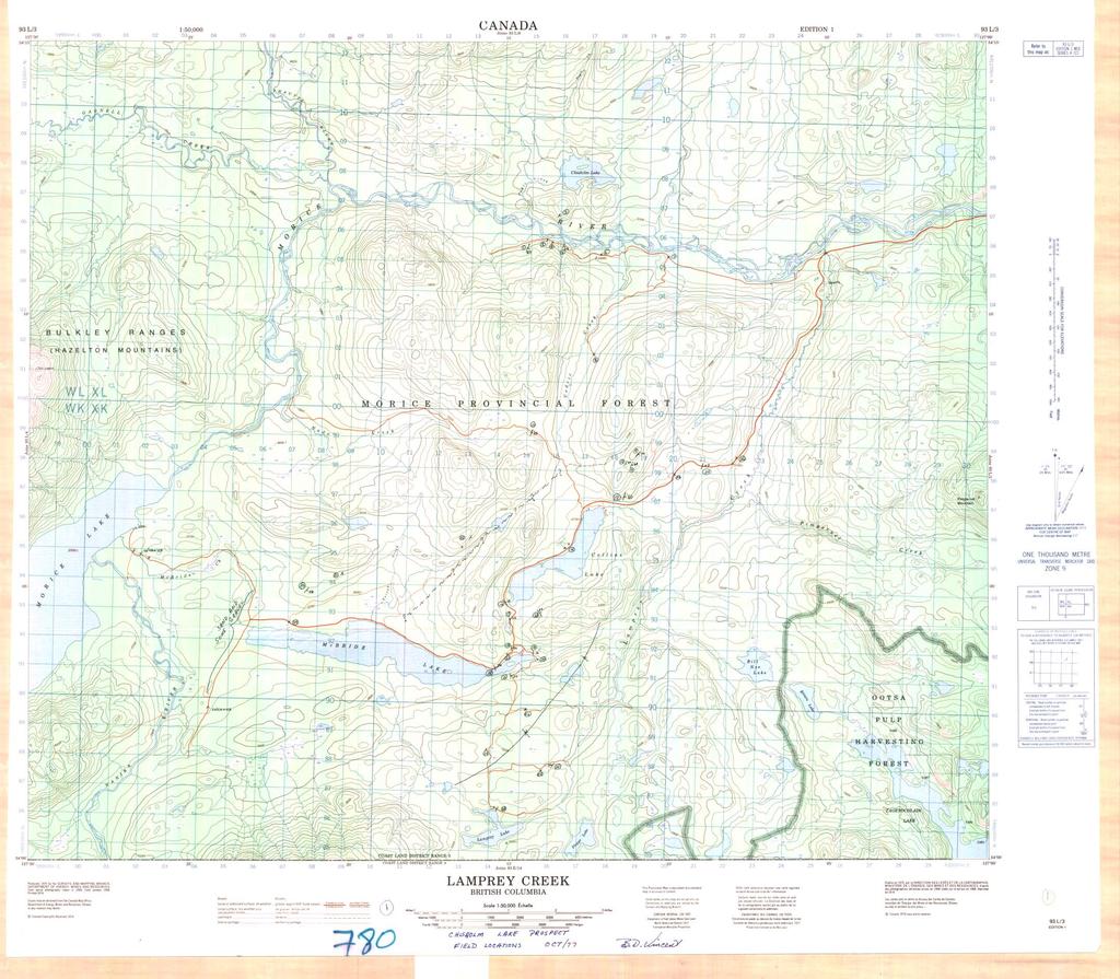
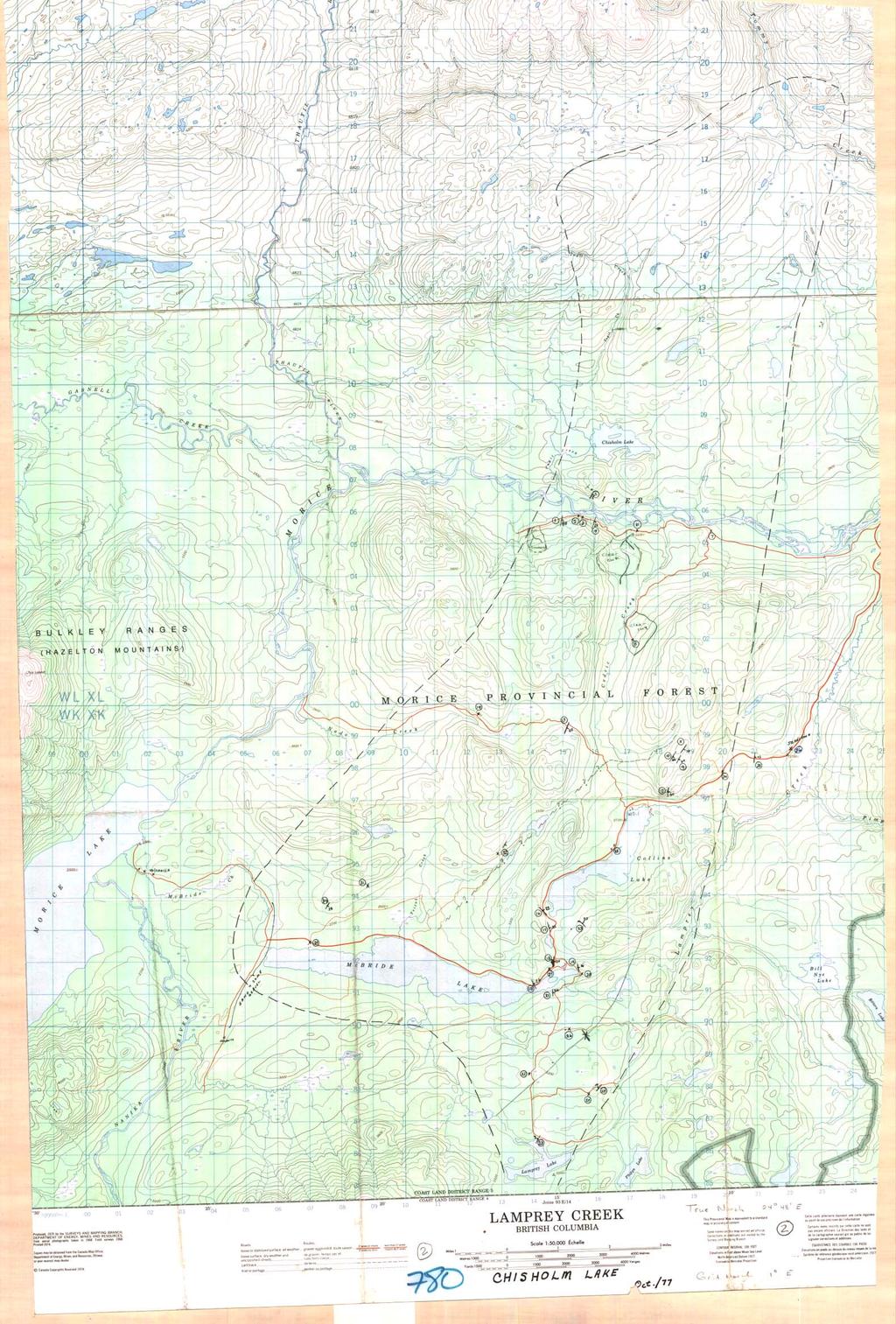
3 Location and Access The original reports of coal seams were from the area of Chisholm Lake, north of the Morice River, about 40 miles west of Houston in north-central British Columbia. See Figure 1. the regional geological map indicated strata of the same age extended for about 13 miles south of the river also. Good access was available to the southern portion of the prospect by numerous lumbering roads. There is no access to the north other than helicopter and so the reported coal occurrences could not be examined.
4
5 Geology The strata has been described as part of the Upper Jurassic - Lower Cretaceous Bowser Assemblage. The outcrop examined consisted primarily of fine to coarse grained, greyish - green, feldspathic or lithic sandstone. These sandstones were massive or exhibited large-scale cross-bedding. They were invariably extremely wellindurated and highly jointed. Evidence of plant remains was rare with a few plant stems and some carbonaceous debris recognized. One ridge of a boulder conglomerate was found. The conglomerate was a clast-supported, chaotic mixture of porphyritic volcanic clasts with a matrix of sand and clay. One outcrop of porphyritic rhyolite was examined. It appeared to be interbedded with the sedimentary rocks. Very limited amounts of finer - grained sediments were seen in the area. That which was seen consisted of brown to black mudstone and carbonaceous shale. No outcrops of coal were seen and no coal bloom was observed. The recessive valleys between the ridges of sandstone appear to be underlain by mudstone. Also there is a thick mantle of glacial debris covering most of the area, especially the valleys.
6 The orientation of the bedding is generally steeply dipping to the east or southeast. The only variation is at the east end of McBride Lake where there appears to be a broad syncline, the axis of which is oriented northeast - southwest. There is no direct evidence of major faulting however, the linearity of several of the valleys suggest they may be structurally controlled and follow fault traces. It is also suspected that the eastern edge of the Bowser outcrop may be faulted.
7 Conclusions The sedimentary rocks examined on the southernportion of the Chisholm Lake prospect appear to have been deposited in a fluvial system. The conglomerate outcrop suggests deposition in an alluvial fan near a mountain front. The volcanogenic nature of the sandstones and the interbedded rhyolite unit shows active vulcanism in the area during the time of deposition. This interpretation and the total lack of coal showings in the southern portion of the prospect suggest no economic coal seams will be found in this area. The reports from the area north of the Morice River mentioned two seams, one 4 inches thick, and one 6 inches thick. It is expected that the same conclusion would be reached about the northern portions.
8 Re,commenda,tions It is concluded that the Chisholm Lake area contains no economic coal reserves. No further consideration of the area should be made.
9 CHISHOLM LAKE PROSPECT STATION DESCRIPTIONS
10 Station Descriptions Refer to 1:50,000 top0 map for locations Station 1 Dark greenish - grey, medium to fine grained sandstone: feldspathic, well-sorted; no apparent sedimentary structures. Bedding (dip direction/dip) 103/83, 105/77 First outcrop on west side of basin. Clear cut to west exposes only till. Station 2 Talus along road between stations 1 and 2. Should be o/c higher on hill. Station 3 Possible outcrop. Fine to medium grained, green sandstone. Extremely hard and well indurated. Bedding, possible (dip direction/dip) 280/53 Station 4 Sandstone, similar to previous outcrops. Possible large-scale cross-bedding perpendicular to dip direction. Bedding (dip-direction/dip) 107/28, 118/23
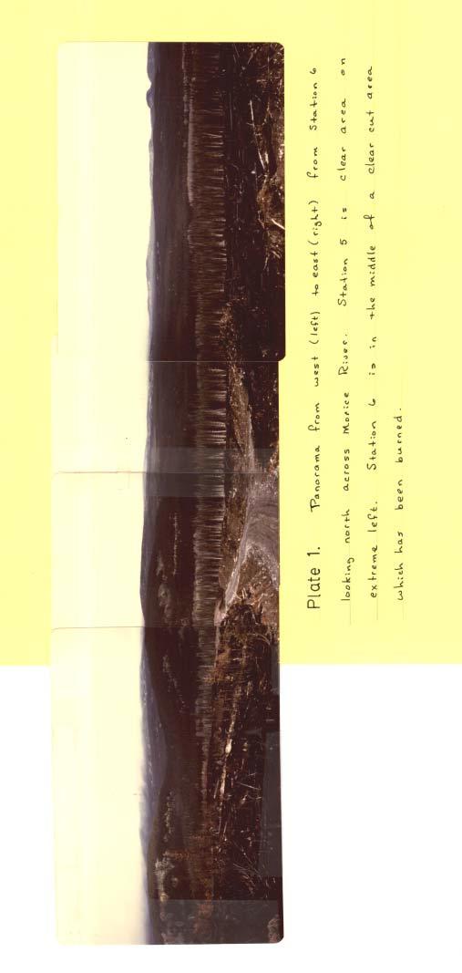
11 Station 5 On north side of river, viewed from Station 4. Large outcrop of sandstone with approximately same bedding orientation as Station 4. Underlain by a recessive unit and then another sandstone. In recessive area, evidence of carbonaceous shale or coal bloom. Station 6 Junction with a logging road. Photos - Panorama from west to east of area north of Morice River. Taken from top of hill in clear cut area. Station 7 Junction of Cedric Creek road. Station 8 End of Cedric Creek road, clear cut area. No outcrop along road or in clear cut. Station 9 Grey, medium grained sandstone: no obvious sedimentary structure. Outcrop near top of hill. Bedding (dip direction/dip) 115/69
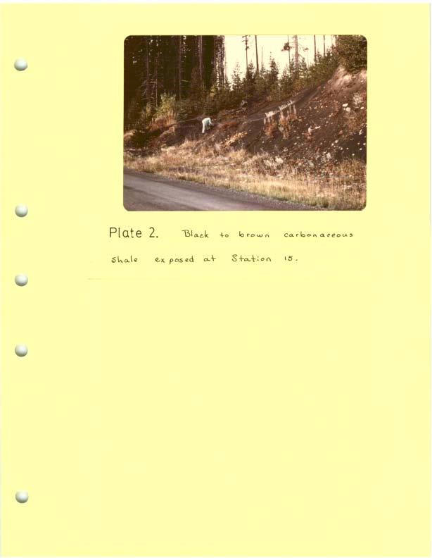
12 v Station 10 Similar sandstone as at station 9. No sign of shales or carbonaceous material. Bedding (dip direction, dip) 123/66 Jointing extremely prominent: at least 2 sets. Station 11 Along strike from station 9. Green-grey, medium to coarse grained sandstone. A lot of feldspathic (volcanic?) material as clasts. Well indurated, highly jointed. Bedding (dip direction/dip) 124/70 Station 12 Medium to coarse grained sandstone: thinnly bedded: pink and white feldspar clasts; extremely jointed; green grey, weathering grey. Station 13 Grey-green, fine to medium grained, massive sandstone; well indurated and highly jointed. Bedding (dip direction/ dip) 113/55 Station 14 Dark grey, parphyritic rhyolite; aphanitic ground mass w Station 15 In road bank, carbonaceous shale exposed by bulldozer. No
13 good outcrop. Continues for 0.1 miles. Consists of black to brown mudstone and some carbenaceous shale. Thinnly bedded, highly fractured, concretions. Bedding obscure; suggest 5 to 10 degree dip toward NE. Photosraph Station 16 Coarse to medium grained sandstone. Green - grey, ark,osic; few plant remains. Bedding (dip direction/dip) 043/22 b Station 17 Coarse to medium grained sandstone; brown to grey; large - scale cross-bedding; some carbonaceous material. Bedding (dip direction/dip) 075,'22 Station 18 Thick bedded, grey-green, medium grained sandstone. Plant fragments. Bedding (dip direction/dip) 094/24 Station 19 Green-brown, medium to coarse grained sandstone; carbonaceous 'clr debris: becomes greener towards base. Bedding (dip direction/dip) 080/16
14 Station 20 Dark grey to black: mudstone, siltstone, and very fine sandstone; highly fractured. Bedding orientation similar to station 19. Station 21 Green grey, medium grained sandstone; large-scale tangential cross-bedding. Should be stratigraphically above mudstone of station 19. Bedding (dip direction/dip) 087/24 w Station 22 Green, fine-grained sandstone; thick bedded; sha,le c lasts. Apparently dipping very gently to east. Station 23 North shore of Lamprey Lake. Grey-green, fine to medium grained sandstone: highly fractured: some veining. Bedding (dip direction/dip) 300/07 Station 24 Green-grey sandstone. MO bedding observed.
15 Station 25 Dark green sandstone. Bedding, very approximate (dip direction/dip) 310/10 Station 26 Green, medium grained sandstone. No bedding seen. Station 27 Road junction Station 28 Medium to fine grained sandstone: grey-green, weathering brownish grey. Large-scale cross-bedding Bedding (dip direction/dip) 065/26 Station 29 Road junction Station 30 Medium to fine grained, brownish-grey sandstone. Numerous plant fragments and carbonaceous debris. Bedding (dip direction/dip) 120/38
16 Sandstone, bedding not obvious. Station 32 Boulder conglomerate. Pebbles from 1" to 2" in diameter. Absolutely no imbrication or preferred orientation to clasts. Sand and clay matrix; clast supported; chaotic. Bedding not found. May be near vertical,parallel to ridge. Clasts are well rounded and are mainly porphyritic volcanics. ~ Station,.33 Sandstone, medium grey-green, fine to medium grained. Large - scale trough cross-bedding. Probably overlain by siltstone. Bedding (dip direction/dip) 045/30 Station 34. Road junction Station 35 Green grey, coarse grained sandstone, highly jointed, slickensides. Bedding (dip direction/dip) 095/43
17 Station 36 Large outcrops of fine-grained, grey-green sandstone, some mudstone.
18
19
20
21
22
23
24
25
26
27
28
29
30
31
32
33
34
35
36
37
38
39
40
Sediment and sedimentary rocks Sediment
 Sediment and sedimentary rocks Sediment From sediments to sedimentary rocks (transportation, deposition, preservation and lithification) Types of sedimentary rocks (clastic, chemical and organic) Sedimentary
PRINCETON BASIN (92H/7E, 8W. 9W, 10E)
") PRINCETON BASIN (92H/7E, 8W. 9W, 10E) By R. D. McMechan INTRODUCTION Remapping of the Princeton basin, south-central British Columbia, was undertaken during the summer of 1975 in order to: (1) produce
PRINCETON BASIN (92H/7E, 8W. 9W, 10E) By R. D. McMechan INTRODUCTION Remapping of the Princeton basin, south-central British Columbia, was undertaken during the summer of 1975 in order to: (1) produce
GEOLOGY OF THE NICOLA GROUP BETWEEN MISSEZULA LAKE AND ALLISON LAKE
 GEOLOGY OF THE NICOLA GROUP BETWEEN MISSEZULA LAKE AND ALLISON LAKE (92H/15E. 10E1 By V. A. Preto INTRODUCTION Mapping was continued southward from the area covered in 1973 and an additional 55 square
REPORT OF GEOLOGICAL MAPPING ON THE MICHEL COAL LICENSE #5177. LOCATION: KOOTENAY LAND DISTRICT NTS 82-G-7 4Y028 Lat f Long.
 i *. REPORT OF GEOLOGICAL MAPPING ON THE MICHEL COAL LICENSE #5177 LOCATION: KOOTENAY LAND DISTRICT NTS 82-G-7 4Y028 Lat. 114 40f Long. ESSO RESOURCES CANADA LIMITED WARD E. KILBY WORK: OCTOBER 17 - OCTOBER
QUINTETTE COAL LIMITED 1979 EXPLORATION ASSESSMENT REPORT
 QUINTETTE COAL LIMITED 1979 EXPLORATION ASSESSMENT REPORT JANUARY 1980 TABLE OF CONTENTS 1.0 Introduction 1.1 Geological Mapping 1.2 Field Camp 2.0 Geology 2.1 Introduction 2.2 Stratigraphy 2.3 Structure
Sedimentary Rocks. Origin, Properties and Identification. Geology Laboratory GEOL 101 Lab Ray Rector - Instructor
 Sedimentary Rocks Origin, Properties and Identification Geology Laboratory GEOL 101 Lab Ray Rector - Instructor Sedimentary Rock Origin and Identification Lab Pre-Lab Internet Link Resources 1) http://www.rockhounds.com/rockshop/rockkey/index.html
Geology 12 FINAL EXAM PREP. Possible Written Response Exam Questions
 Geology 12 FINAL EXAM PREP Possible Written Response Exam Questions Use this study guide to prepare for the written response portion of the final exam. Name FINAL EXAM - POSSIBLE WRITTEN RESPONSE QUESTIONS
Sediment. Weathering: mechanical and chemical decomposition and disintegration of rock and minerals at the surface
 Sediment Some basic terminology Weathering: mechanical and chemical decomposition and disintegration of rock and minerals at the surface Erosion: removal of weathered rock and minerals from one place to
Sediment and Sedimentary rock
 Sediment and Sedimentary rock Sediment: An accumulation of loose mineral grains, such as boulders, pebbles, sand, silt or mud, which are not cemented together. Mechanical and chemical weathering produces
Paleo Lab #4 - Sedimentary Environments
 Paleo Lab #4 - Sedimentary Environments page - 1. CHARACTERISTICS OF SEDIMENT Grain size and grain shape: The sizes and shapes of sedimentary particles (grains) are modified considerably during their transportation
Sedimentary Rocks. Origin, Properties and Identification. Physical Geology GEOL 101 Lab Ray Rector - Instructor
 Sedimentary Rocks Origin, Properties and Identification Physical Geology GEOL 101 Lab Ray Rector - Instructor Sedimentary Rock Origin and Identification Lab Pre-Lab Internet Link Resources 1) http://www.rockhounds.com/rockshop/rockkey/index.html
NOA ASSESSMENT HARRIS QUARRY MENDOCINO COUNTY, CALIFORNIA TABLE OF CONTENTS
 NOA ASSESSMENT HARRIS QUARRY MENDOCINO COUNTY, CALIFORNIA TABLE OF CONTENTS Introduction... 1 Scope of Services... 1 Project Location and Description... 1 Geologic Setting... 1 Regional Geology... 1 Site
High-resolution Sequence Stratigraphy of the Glauconitic Sandstone, Upper Mannville C Pool, Cessford Field: a Record of Evolving Accommodation
 Page No. 069-1 High-resolution Sequence Stratigraphy of the Glauconitic Sandstone, Upper Mannville C Pool, Cessford Field: a Record of Evolving Accommodation Thérèse Lynch* and John Hopkins, Department
Sedimentary Rocks. Origin, Properties and Identification. Physical Geology GEOL 100. Ray Rector - Instructor
 Sedimentary Rocks Origin, Properties and Identification Physical Geology GEOL 100 Ray Rector - Instructor Sedimentary Rock Origin and Identification Lab Pre-Lab Internet Link Resources 1) http://www.rockhounds.com/rockshop/rockkey/index.html
GEOLOGY MEDIA SUITE Chapter 5
 UNDERSTANDING EARTH, SIXTH EDITION GROTZINGER JORDAN GEOLOGY MEDIA SUITE Chapter 5 Sedimentation Rocks Formed by Surface Processes 2010 W.H. Freeman and Company Mineralogy of sandstones Key Figure 5.12
Maine Geologic Facts and Localities October, Lobster Lake, Maine. Text by Robert G. Marvinney. Maine Geological Survey
 Maine Geologic Facts and Localities October, 1998 Lobster Lake, Maine 45 o 51 7.91 N, 69 o 30 53.88 W Text by Robert G. Marvinney, Department of Agriculture, Conservation & Forestry 1 Map by Introduction
3. GEOLOGY. 3.1 Introduction. 3.2 Results and Discussion Regional Geology Surficial Geology Mine Study Area
 3. GEOLOGY 3.1 Introduction This chapter discusses the baseline study of the geology and mineralization characteristics of the mine study area. The study consolidates existing geological data and exploration
Daniel Koning, Peggy Johnson, and John Hawley. New Mexico Bureau of Geology and Mineral Resources
 Daniel Koning, Peggy Johnson, and John Hawley Daniel Koning 1, Gary Smith 2, and Adam Read 1 1 New Mexico Bureau of Geology and Mineral Resources 2 University of New Mexico Santa Fe Group Definition (Spiegel
LINGUAU DEPOSITION IN THE WOODBINE SANDS ALONG COPPERAS BRANCH, DENTON COUNTY. TEXAS: A STUDY IN MARINE SEDIMENTATION
 LINGUAU DEPOSITION IN THE WOODBINE SANDS ALONG COPPERAS BRANCH, DENTON COUNTY. TEXAS: A STUDY IN MARINE SEDIMENTATION Ellis W. Shuler and Olin M. Millican The lack of outcrops in three dimensions often
GEOLOGY 470 FIELD EXERCISE 3, SPRING SKETCHING, DESCRIBING, AND MAPPING EXPOSURES
 GEOLOGY 470 FIELD EXERCISE 3, SPRING 2009 -- SKETCHING, DESCRIBING, AND MAPPING EXPOSURES 1 OBJECTIVES: To develop and refine your field skills in: 1. observation and rock and sediment description 2. sketching
SL GEOLOGY AND MINING. Coal bearing strata in the project area are referable primarily to the Allegheny Group of
 SL-145-1 GEOLOGY AND MINING Coal bearing strata in the project area are referable primarily to the Allegheny Group of Pennsylvania age. These rocks occur as dissected remnants overlying the ridge-forming
EPS 50 Lab 4: Sedimentary Rocks
 Name: EPS 50 Lab 4: Sedimentary Rocks Grotzinger and Jordan, Chapter 5 Introduction In this lab we will classify sedimentary rocks and investigate the relationship between environmental conditions and
Lab 7: Sedimentary Structures
 Name: Lab 7: Sedimentary Structures Sedimentary rocks account for a negligibly small fraction of Earth s mass, yet they are commonly encountered because the processes that form them are ubiquitous in the
GeoCanada 2010 Working with the Earth
 Lithofacies Identification and the Implications for SAGD Well Planning in the McMurray Formation, Christina Lake Area, Alberta Travis Shackleton*, Robert Gardner, Sung Youn, Grace Eng and Lori Barth Cenovus
Sediments and. Sedimentary Rocks
 Sediments and Sedimentary Rocks Bottom Line Sedimentary rocks form from particles accumulated in sedimentary layers Sedimentary layers can be formed by clastic or detrital particles (e.g., sand grains,
Sedimentary Structures in Metamorphic Rocks
 Maine Geologic Facts and Localities November, 2006 Primary Sedimentary Structures in Some Metamorphic Rocks Text by Thomas K. Weddle, Department of Agriculture, Conservation & Forestry 1 Photo by Thomas
A Sedimentary Rock is..
 Sedimentary Rocks A Sedimentary Rock is.. rock formed from the lithification or crystallization of: 1. Minerals in solution 2. Organic remains 3. Materials produced by living things (biochemical) 4. Clastic
Cape Breton Island Mineral Inventory Studies: A Sandstone Quarry Development Opportunity at Graham River (NTS 11F/14), Inverness County
, Inverness County") Report of Activities 2001 23 Cape Breton Island Mineral Inventory Studies: A Sandstone Quarry Development Opportunity at Graham River (NTS 11F/14), Inverness County G. J. DeMont and J. E. Hawken Compilation
Report of Activities 2001 23 Cape Breton Island Mineral Inventory Studies: A Sandstone Quarry Development Opportunity at Graham River (NTS 11F/14), Inverness County G. J. DeMont and J. E. Hawken Compilation
Structural Geology Lab. The Objectives are to gain experience
 Geology 2 Structural Geology Lab The Objectives are to gain experience 1. Drawing cross sections from information given on geologic maps. 2. Recognizing folds and naming their parts on stereoscopic air
Summary. Introduction. Observations and Interpretations
 Lower McMurray Formation sinkholes and their fill fabrics: effects of salt dissolution collapse-subsidence across the northern Athabasca oil sands deposit Paul L. Broughton, Chevron Canada Resources, Calgary,
Chapter 6 Sedimentary and Metamorphic Rock
 Chapter 6 Sedimentary and Metamorphic Rock Weathering and Erosion Wherever rock is exposed at Earth s surface, it is continuously being broken down by weathering a set of physical and chemical processes
MEMO. TO: Dennis Lapoint CC: FROM: Eriaan Wirosono DATE: April, 20 th 2014 SUBJECT: Exploration activity report March-April 2014_EW
 TO: Dennis Lapoint CC: FROM: Eriaan Wirosono DATE: April, 20 th 2014 SUBJECT: Exploration activity report March-April 2014_EW MEMO 1. Highlights and Productivity Overview pan sampling on target Areas 1
COMPOSITIONAL TERMS: FELSIC : light colored INTERMEDIATE : medium shades MAFIC : dark colored ULTRAMAFIC : rare (composition of the mantle)
") GEOLOGY 306 Laboratory NAME: Instructor: TERRY J. BOROUGHS SECTION: Common Rocks (Chapter 2) For this assignment, you will require: a streak plate, glass plate, magnet, dilute hydrochloric (HCl) acid,
GEOLOGY 306 Laboratory NAME: Instructor: TERRY J. BOROUGHS SECTION: Common Rocks (Chapter 2) For this assignment, you will require: a streak plate, glass plate, magnet, dilute hydrochloric (HCl) acid,
Cretaceous, Dakota Formation, Terra Cotta Member South Side of I-70, Salina County, Kansas
 Cretaceous, Dakota Formation, Terra Cotta Member South Side of I-70, Salina County, Kansas Written By: Steven D.J. Baumann G-102010-1A Outcrop looking southeast Photo taken by: Steven Baumann on 10-20-2010
Field trip guide to the Marin Headlands (Golden Gate National Recreation Area) and the Point Reyes National Seashore
 and the Point Reyes National Seashore") Name: Field trip guide to the Marin Headlands (Golden Gate National Recreation Area) and the Point Reyes National Seashore Geology of the National Parks San Francisco State University April 20, 2002 DRIVING
Name: Field trip guide to the Marin Headlands (Golden Gate National Recreation Area) and the Point Reyes National Seashore Geology of the National Parks San Francisco State University April 20, 2002 DRIVING
Page 1. Name:
 Name: Questions 1 through 3 refer to the following: The diagrams below represent two rock outcrops found several miles apart in New York State. Individual rock layers are lettered, and fossils and rock
Data Repository item
 Data Repository (B25407): Localities and descriptions of measured sections of study areas Table 1. Localities of the measured sedimentary sections in the NW Sichuan Basin Section Number Stratigraphy Locality
Journal of Sedimentary Environments Published by Universidade do Estado do Rio de Janeiro SM2: doi: /jse SUPPLEMENTARY MATERIAL
 Appendix 2 Citation: Bergamaschi, S., Duarte, A.C.F., Serrano, J.S., Figueiredo, A.M.B., Vasconcelos, L.C., Oliveira, R.M.A.G., Ade, M.V.B., Pinheiro, A.E.P.P., Martins, M.V.A., 2016. Regional outcrops
Sedimentary Rocks. Weathering. Mechanical & Chemical Weathering. Sediments. Lithification. Deposition. Transport. Erosion.
 Lithification Sedimentary Rocks Sediments Deposition Transport Erosion Weathering Weathering The sediments that make up sedimentary rocks are produced by: Mechanical & Chemical Weathering Mechanical Weathering
GLG Chapter 7 Sedimentary Environments & Rocks
 GLG 101 - Chapter 7 Sedimentary Environments & Rocks Name Note, Oct 11: I ll be writing this study sheet over the next few days. Each day I will add questions until the entire chapter is done, hopefully
 1-6 Figure 1.3. View of the field area, looking south-southwest. Left side of the picture shows the steep flank of the Green Mountain massif. The Vermont Valley and the Tinmouth Valley are separated by
Reconnaissance. Of the. Denis mineral claims. Situated at Kilometer 844 of the Alaska Highway. Liard Mining Division. Northeastern British Columbia
 Reconnaissance Of the Denis mineral claims Situated at Kilometer 844 of the Alaska Highway Liard Mining Division Northeastern British Columbia N.T.S. 94M.075 Latitude 59 42 25 Longitude 127 13 12 Field
The geology of the Vermont Valley and the western flank of the Green Mountains between Dorset Mountain and Wallingford, Vermont
 University at Albany, State University of New York Scholars Archive Geology Theses and Dissertations Atmospheric and Environmental Sciences 1992 The geology of the Vermont Valley and the western flank
THE STRUCTURE AND THICKNESS OF THE CLINTON AND BEREA FORMATIONS IN THE VICINITY OF WOOSTER, OHIO
 THE STRUCTURE AND THICKNESS OF THE CLINTON AND BEREA FORMATIONS IN THE VICINITY OF WOOSTER, OHIO KARL VER STEEG College of Wooster INTRODUCTION AND ACKNOWLEDGMENTS The data used in the construction of
ASSESSMENT REPORT GEOLOGICAL BRANCH. 50' 23 'North. GEOLOGICAL and GEOCHEMICAL SURVEYS ON THE. PUTNAM PROPERTY (Putnam Mineral Claim)
") GEOLOGICAL and GEOCHEMICAL SURVEYS ON THE PUTNAM PROPERTY (Putnam Mineral Claim) VERNON MINING DIVISION, B.C. GEOLOGICAL BRANCH ASSESSMENT REPORT NTS : Latitude: 82L17W 50' 23 'North LOCATION, ACCESS,
GEOLOGICAL and GEOCHEMICAL SURVEYS ON THE PUTNAM PROPERTY (Putnam Mineral Claim) VERNON MINING DIVISION, B.C. GEOLOGICAL BRANCH ASSESSMENT REPORT NTS : Latitude: 82L17W 50' 23 'North LOCATION, ACCESS,
Answers. Rocks. Year 8 Science Chapter 8
 Answers Rocks Year 8 Science Chapter 8 p171 1 Rocks are made up of minerals such as quartz, feldspars, micas, and calcite. Different rocks are made up of different combinations of minerals. 2 Igneous,
American Institute of Professional Geologists South Dakota Section
 American Institute of Professional Geologists South Dakota Section 2015 Field Trip Guide Deadwood Formation in the Black Hills of South Dakota and Frac Sand Potential Saturday, September 12, 2015 1 Field
Structural Deformation and Karst in the Devonian Waterways Formation: Examples from Outcrops along the Athabasca River*
 Structural Deformation and Karst in the Devonian Waterways Formation: Examples from Outcrops along the Athabasca River* Chris L. Schneider 1 and Matthias Grobe 2 Search and Discovery Article #51073 (2015)
ENGINEER S CERTIFICATION OF FAULT AREA DEMONSTRATION (40 CFR )
") PLATTE RIVER POWER AUTHORITY RAWHIDE ENERGY STATION BOTTOM ASH TRANSFER (BAT) IMPOUNDMENTS LARIMER COUNTY, CO ENGINEER S CERTIFICATION OF FAULT AREA DEMONSTRATION (40 CFR 257.62) FOR COAL COMBUSTION RESIDUALS
PLATTE RIVER POWER AUTHORITY RAWHIDE ENERGY STATION BOTTOM ASH TRANSFER (BAT) IMPOUNDMENTS LARIMER COUNTY, CO ENGINEER S CERTIFICATION OF FAULT AREA DEMONSTRATION (40 CFR 257.62) FOR COAL COMBUSTION RESIDUALS
Figure 1 The map shows the top view of a meandering stream as it enters a lake. At which points along the stream are erosion and deposition dominant?
 1. In which type of climate does chemical weathering usually occur most rapidly? 1. hot and dry 3. cold and dry 2. hot and wet 4. cold and wet 2. Figure 1 The map shows the top view of a meandering stream
Lower Skinner Valley Fill Sandstones: Attractive Exploration Targets on the Northeast Oklahoma Platform*
 Lower Skinner Valley Fill Sandstones: Attractive Exploration Targets on the Northeast Oklahoma Platform* By Jim Puckette 1 Search and Discovery Article #10050 (2003) *Adapted from presentation to Tulsa
INTRODUCTION. Climate
 INTRODUCTION Climate Landslides are serious natural disasters in many parts of the world. Since the past 30 years, rainfall triggered landslides and debris flows had been one of the natural disasters of
SOUTH CERRO AZUL STRATIGRAPHIC SECTION. Upper Cerro Azul flow of the Servilleta Basalt (Tsbcau) Lower Sandlin unit (Tsl)
 Lower Sandlin unit (Tsl)") Figure A3-01 cobbles claysilt general grain size sand pebbles vf f m c vc SOUTH CERRO AZUL STRATIGRAPHIC SECTION Top at 18 m. Upper Cerro Azul flow of the Servilleta Basalt (Tsbcau) 15 Basalt: Very dark
Figure A3-01 cobbles claysilt general grain size sand pebbles vf f m c vc SOUTH CERRO AZUL STRATIGRAPHIC SECTION Top at 18 m. Upper Cerro Azul flow of the Servilleta Basalt (Tsbcau) 15 Basalt: Very dark
Data Repository item DATA REPOSITORY
 Data Repository item 2003053 1 DATA REPOSITORY Stable isotope and trace-element geochemistry of the basal Bouse Formation carbonate, southwestern USA: Implications for the Pliocene uplift history of the
The Geology of Two Lights State Park. Cape Elizabeth, Maine
 Maine Geologic Facts and Localities June, 2002 Cape Elizabeth, Maine 43 33 33.48 N, 70 12 13.32 W Text by Henry N. Berry IV and Robert G. Marvinney, Department of Agriculture, Conservation & Forestry 1
N. J. Macala. C ONTENT S. LIST OF PLATES.
 REPORT ON WATER SUikLY AT MANBULLOO STATION, NORTHERN TERRITORY. by N. J. Macala. Records 1957/62. C ONTENT S. Page. Introduction. 1. General Geology, 1. Hydrology. 1. New Bore Sites Selected. 2. Reference.
Connecticut's Aquifers
 Page 1 of 5 DEP Search: Connecticut's Aquifers The technical definition of the word "aquifer" is: any geologic formation capable of yielding significant quantities of water to wells. By that definition,
GEL 109 Midterm W01, Page points total (1 point per minute is a good pace, but it is good to have time to recheck your answers!
 GEL 109 Midterm W01, Page 1 50 points total (1 point per minute is a good pace, but it is good to have time to recheck your answers!) 1. Where in a water flow is there usually a zone of laminar flow even
This file was created by scanning the printed publication. Errors identified by the software have been corrected; however, some errors may remain.
 This file was created by scanning the printed publication. Errors identified by the software have been corrected; however, some errors may remain. GEOLOGY OF TENDERFOOT CREEK EXPERIMENTAL FOREST LITTLE
A Sedimentary Rock is..
 Sedimentary Rocks A Sedimentary Rock is.. rock formed from the lithification or crystallization of: 1. Minerals in solution 2. Organic remains 3. Materials produced by living things (biochemical) 4. Clastic
Black Point & Bihler Point
 Black Point & Bihler Point Conglomerate Photo: looking north toward end of Black Point (south of post 1) All of the rocks in this photo are conglomerate. Both Black Point and Bihler Point are formed from
ENGLE COAL FIELD. David E. Tabet
 OPEN FILE REPORT 115 SUMMARY OF THE GEOLOGY OF THE ENGLE COAL FIELD by David E. Tabet THE ENGLE COAL FIELD Introduction The Engle coal field (Lee, 1905), named for the small town of Engle along the Santa
Sedimentary Rocks, our most Valuable Rocks. Or, what you will probably find when you are outdoors exploring.
 Sedimentary Rocks, our most Valuable Rocks Or, what you will probably find when you are outdoors exploring. Sedimentary rocks give us evidence to earth s earlier history. We look at processes happening
Photo 119. Ripple marks in the Gordon Lake Formation. Highway 639 at the entrance to Laurentian Lodge.
 in particular of the Bruce Limestone by the Nipissing Diabase, has produced the rocks known as skarns (page 162). Regional metamorphism, particularly in the Massey - Whitefish Falls area, has produced
2013 GEOLOGICAL ASSESSMENT REPORT SHERIDAN HILL PROPERTY
 2013 GEOLOGICAL ASSESSMENT REPORT ON THE SHERIDAN HILL PROPERTY NEW WESTMINSTER MINING DIVISION BRITISH COLUMBIA NTS 092G07 49 16 31 NORTH LATITUDE, 122 39 48 WEST LONGITUDE PREPARED FOR Sheridan Hill
Module 9 Sedimentary Rocks
 Module 9 Sedimentary Rocks SEDIMENTARY ROCKS Rocks formed from material derived from preexisting rocks by surfacial processes followed by diagenesis There are two main classes of sedimentary rocks Clastic
GEOLOGY 435 FIELD EXERCISE 2, SPRING SKETCHING, DESCRIBING, AND MAPPING EXPOSURES OBJECTIVES:
 OBJECTIVES: GEOLOGY 435 FIELD EXERCISE 2, SPRING 2016 -- SKETCHING, DESCRIBING, AND MAPPING EXPOSURES To develop and refine your field skills in: 1. observation and rock and sediment description 2. sketching
As compaction and cementation of these sediments eventually occur, which area will become siltstone? A) A B) B C) C D) D
 A B) B C) C D) D") 1. A student obtains a cup of quartz sand from a beach. A saltwater solution is poured into the sand and allowed to evaporate. The mineral residue from the saltwater solution cements the sand grains together,
1. A student obtains a cup of quartz sand from a beach. A saltwater solution is poured into the sand and allowed to evaporate. The mineral residue from the saltwater solution cements the sand grains together,
Sedimentology, Petrography, and Mineralogy of the Tallahatta Formation near the City of Meridian, Mississippi
 Sedimentology, Petrography, and Mineralogy of the Tallahatta Formation near the City of Meridian, Mississippi Kiana McFadden and Ezat Heydari Department of Physics, Atmospheric Sciences, and Geoscience,
Mud Sand Gravel. Clastic Textures
 Sed Rocks Self-Instruction Lab Name Geology 100 Harbor Section Please see the questions online before you begin. Sedimentary rocks are usually identified in the field by their stratification or layering,
Mud Sand Gravel. Clastic Textures
 Sed Rocks Self-Instruction Lab Name Geology 100 Harbor Section Read the sedimentary rocks chapter before you start. Sedimentary rocks are usually identified in the field by their stratification or layering,
Geology 252, Historical Geology, California State University, Los Angeles - professor: Dr. Alessandro Grippo
 LAB # 1 - CLASTIC ROCKS Background: - Mechanical and Chemical Weathering - Production of Clastic Sediment - Classification of Sediment according to size: Gravel, Sand, Silt, Clay - Erosion, Transportation
The Welsh Borderland. Geologically recent surface deposits. The Welsh Borderland
 The Welsh Borderland This account provides a broad perspective of the geology of the Welsh Borderland region which comprises the southeast of Powys, southern Shropshire, northern Gwent, the western half
GEOLOGIC MAP OF THE. CHESTER 30 x 60 QUADRANGLE NORTH-CENTRAL MONTANA
 GEOLOGIC MAP OF THE CHESTER 30 x 60 QUADRANGLE NORTH-CENTRAL MONTANA by David A. Lopez Montana Bureau of Mines and Geology Open File Report MBMG 445 2002 This map has had preliminary reviews for conformity
Clastic Sedimentary Rocks
 Clastic Sedimentary Rocks Alessandro Grippo, Ph.D. Alternating sandstones and mudstones in Miocene turbidites Camaggiore di Firenzuola, Firenze, Italy Alessandro Grippo review Mechanical weathering creates
NAME: GEL 109 Final Winter 2010
 GEL 109 Final Winter 2010 1. The following stratigraphic sections represents a single event followed by the slow accumulation of background sedimentation of shale. Describe the flows that produced the
The Geology of Sebago Lake State Park
 Maine Geologic Facts and Localities September, 2002 43 55 17.46 N, 70 34 13.07 W Text by Robert Johnston, Department of Agriculture, Conservation & Forestry 1 Map by Robert Johnston Introduction Sebago
Sediments and Sedimentary Rocks
 Sediments and Sedimentary Rocks (Shaping Earth s Surface, Part 2) Science 330 Summer 2005 What is a sedimentary rock? Products of mechanical and chemical weathering Account for about 5 percent of Earth
UNIT 4 SEDIMENTARY ROCKS
 UNIT 4 SEDIMENTARY ROCKS WHAT ARE SEDIMENTS Sediments are loose Earth materials (unconsolidated materials) such as sand which are transported by the action of water, wind, glacial ice and gravity. These
Answers: Internal Processes and Structures (Isostasy)
") Answers: Internal Processes and Structures (Isostasy) 1. Analyse the adjustment of the crust to changes in loads associated with volcanism, mountain building, erosion, and glaciation by using the concept
Answers: Internal Processes and Structures (Isostasy) 1. Analyse the adjustment of the crust to changes in loads associated with volcanism, mountain building, erosion, and glaciation by using the concept
GIFFORD PINCHOT STATE PARK DIABASE (MOLTEN LIQUID ROCK)
") PENNSYLVANIA TRAIL OF GEOLOGY PARK GUIDE 10 GIFFORD PINCHOT STATE PARK DIABASE (MOLTEN LIQUID ROCK) Gifford Pinchot State Park contains examples of the three major rock classes: igneous, metamorphic, and
PENNSYLVANIA TRAIL OF GEOLOGY PARK GUIDE 10 GIFFORD PINCHOT STATE PARK DIABASE (MOLTEN LIQUID ROCK) Gifford Pinchot State Park contains examples of the three major rock classes: igneous, metamorphic, and
1. Base your answer to the following question on the map below, which shows the generalized bedrock of a part of western New York State.
 1. Base your answer to the following question on the map below, which shows the generalized bedrock of a part of western New York State. 3. The table below describes the deposits that an observer saw while
Understanding Earth Fifth Edition
 Understanding Earth Fifth Edition Grotzinger Jordan Press Siever Chapter 5: SEDIMENTATION: Rocks Formed by Surface Processes Lecturer: H Mohammadzadeh Assistant professors, Department of Geology, FUM Copyright
The Kingfisher Field, Uganda - A Bird in the Hand! S R Curd, R Downie, P C Logan, P Holley Heritage Oil plc *
 A Bird in the Hand! EXTENDED ABSTRACT The Kingfisher Field, Uganda - A Bird in the Hand! Heritage Oil plc * The Kingfisher Field lies on Uganda s western border beneath Lake Albert, situated in the western
Objectives: Define Relative Age, Absolute Age
 S6E5. Students will investigate the scientific view of how the earth s surface is formed. c. Classify rocks by their process of formation. g. Describe how fossils show evidence of the changing surface
 19 00' N 70 20' W Loma La Cuaba volcanic edifice 70 00' W Pueblo Viejo District (location of Fig. 2) Loma Navisa volcanic edifice 69 40' W & S a m a n á B a y 0 10 20 Kilometers 18 50' N Guaimarote Hatillo
Lecture Outline Wednesday - Friday February 14-16, 2018
 Lecture Outline Wednesday - Friday February 14-16, 2018 Quiz 2 scheduled for Friday Feb 23 (Interlude B, Chapters 6,7) Questions? Chapter 6 Pages of the Past: Sedimentary Rocks Key Points for today Be
A Geological Tour of Tumbledown Mountain, Maine
 Maine Geologic Facts and Localities April, 1998 A Geological Tour of Tumbledown Mountain, Maine 44 45 3.21 N, 70 32 50.24 W Text by Robert G. Marvinney, Department of Agriculture, Conservation & Forestry
A. IGNEOUS Rocks formed by cooling and hardening of hot molten rock called magma (within crust or at its surface).
.") EARTH SCIENCE 11 CHAPTER 5 NOTES KEY How Earth's Rocks Were Formed Early geologists believed that the physical features of the Earth were formed by sudden spectacular events called CATASTROPHES. Modern
EARTH SCIENCE 11 CHAPTER 5 NOTES KEY How Earth's Rocks Were Formed Early geologists believed that the physical features of the Earth were formed by sudden spectacular events called CATASTROPHES. Modern
Rock Identification. invisible rhyolite andesite basalt komatiite. visible granite diorite gabbro peridotite
 Rock Identification The samples in this lab are arranged into four groups: igneous, sedimentary, metamorphic, and unknown. Study the igneous, sedimentary, and metamorphic collections to get an idea of
GEOL.3250 Geology for Engineers Sedimentary & Metamorphic Rocks
 GEOL.3250 Geology for Engineers Sedimentary & Metamorphic Rocks Name I. Introduction The bulk of the earth's crust is composed of relatively few minerals. These can be mixed together, however, to give
CASE STUDY #9 - Brushy Fork Dam, Sugar Grove, West Virginia
 CASE STUDY #9 - Brushy Fork Dam, Sugar Grove, West Virginia Brushy Fork Dam is a flood control structure built by the Soil Conservation Service southeast of the city of Franklin in Pendleton County, West
To get you thinking Explain how these different layers of rock formed? Why are these layers different colors? Sedimentary Rocks
 To get you thinking Explain how these different layers of rock formed? Why are these layers different colors? Sedimentary Rocks Bryce Canyon, Utah Badlands, South Dakota Weathering Whenever rock is exposed
Stratigraphy and structure of the Ganson Hill area: northern Taconic Allochthon
 University at Albany, State University of New York Scholars Archive Geology Theses and Dissertations Atmospheric and Environmental Sciences 1985 Stratigraphy and structure of the Ganson Hill area: northern
Geology of Quesnel and Stikine terranes and associated porphyry deposits. Jim Logan Paul Schiarizza
 Geology of Quesnel and Stikine terranes and associated porphyry deposits Jim Logan Paul Schiarizza Quesnel and Stikine terranes Major cordilleran terranes characterized by similar Late Triassic Early Jurassic
Chapter 10. Chapter Rocks and the Rock Cycle. Rocks. Section 1 Rocks and the Rock Cycle
 Chapter 10 Rocks 1 Chapter 10 Section 1 Rocks and the Rock Cycle 2 10.1 Rocks and the Rock Cycle Magma is the parent material for all rocks. Once the magma cools and hardens, many changes can occur. Geology:
ESC102. Sedimentary Rocks. Our keys to the past. Monday, February 11, 13
 ESC102 Sedimentary Rocks Our keys to the past Sedimentary Rocks Sedimentary rocks are rocks that form through the accumulation of sediment and the process of lithification. Lithification occurs after deposition
PROSPECTING REPORT. Broken Hill Property. EVENT # TENURE # Tenure Name: Broken Hill. New Westminster Mining Division Map 092H
 2009-2010 PROSPECTING REPORT Broken Hill Property EVENT # 4514071 TENURE # 600988 Tenure Name: Broken Hill New Westminster Mining Division Map 092H Central Coordinate Reference 121 24 26.2 W Longitude
Ministry of Minerals Geological Research Authority of Sudan (GRAS)
") ﺑﺴﻢ اﷲ اﻟﺮﺣﻤﻦ اﻟﺮﺣﯿﻢ Ministry of Minerals Geological Research Authority of Sudan (GRAS) Bentonite Deposits of Omm Ali Area (River Nile State) Sudan By: El Gizouli Ahmed Hamid. February 2011 Abstract The
ﺑﺴﻢ اﷲ اﻟﺮﺣﻤﻦ اﻟﺮﺣﯿﻢ Ministry of Minerals Geological Research Authority of Sudan (GRAS) Bentonite Deposits of Omm Ali Area (River Nile State) Sudan By: El Gizouli Ahmed Hamid. February 2011 Abstract The