Field trip guide to the Marin Headlands (Golden Gate National Recreation Area) and the Point Reyes National Seashore
|
|
|
- Irma Anabel Harrison
- 6 years ago
- Views:
Transcription
1 Name: Field trip guide to the Marin Headlands (Golden Gate National Recreation Area) and the Point Reyes National Seashore Geology of the National Parks San Francisco State University April 20, 2002 DRIVING DIRECTIONS Start at SFSU Drive 19 th Avenue (Highway 1) north toward the Golden Gate Bridge Cross the Golden Gate Bridge Exit Highway 1/101 north at the 2 nd exit after the bridge (not the Vista Point exit) to Alexander Ave. Turn left and cross underneath Highway 101 Turn right onto Barry Rd. just before re-entering Highway 101 to cross back over the bridge Stop at the top of the hill at the first dirt parking area this is STOP #1 Return to Highway 101 north Drive north past San Rafael and exit Lucas Valley Road to the west Turn right onto Nicasio Valley Road after about 10 miles At the T-junction, turn left onto Point Reyes Road Stop at the junction with Laural Canyon Road this is STOP #2 Continue on Point Reyes Road Turn right onto Point Reyes/Petaluma Road Turn left onto Shoreline Road toward Highway 1 south Turn right onto Sir Francis Drake Blvd. toward Inverness Drive to the Point Reyes lighthouse this is STOP #3 Return along Sir Francis Drake Blvd. Turn left onto Pierce Point Road After about 5 miles, we will park and take the trail down toward the beach this is STOP #4 Return along Pierce Point Road and turn left onto Sir Francis Drake Blvd. Turn right onto Bear Valley Road Turn right into the Visitor's Center and Park Headquarters this is STOP #5 Return via Sir Francis Drake Blvd.
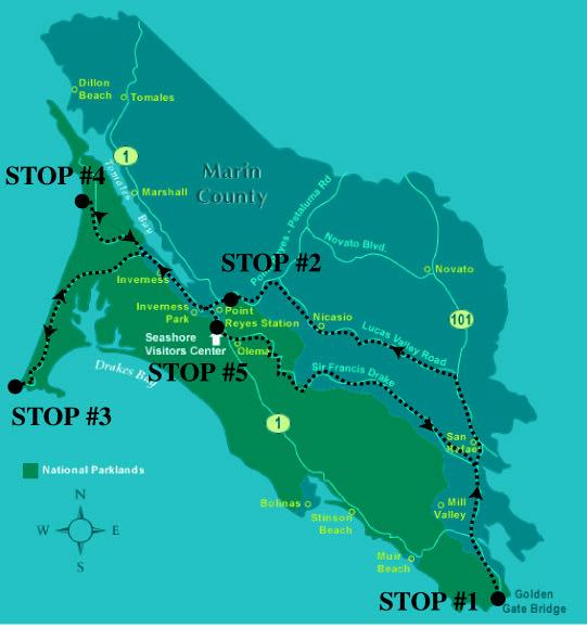
2 ROUTE MAP

3 GEOLOGY STOPS AND QUESTIONS TO ANSWER STOP 1 Marin Headlands, Golden Gate National Recreation Area Questions to answer What is chert? What is the name of the micro-fossils that comprise the chert here? How big are these micro-fossils? Where did this chert form and how did it get where it is today?
4 STOP 2 Nicasio Reservoir Terrane Questions to answer What is this rock type? Where did it form? How did it get here? Why is it dark-colored? What gives these rocks their pillow shape?

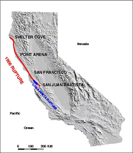
5 THE SAN ANDREAS FAULT IN CALIFORNIA GENERAL GEOLOGY MAP OF THE POINT REYES NATIONAL SEASHORE
 molten rocks formed (sometimes invading and literally \"cooking\" the prexisting rocks and creating the peninsula's metamorphic rocks).")
6 STOP #3 POINT REYES LIGHTHOUSE Granitic Rocks of Pt. Reyes In the far distance past (110 million years ago) molten rocks formed (sometimes invading and literally "cooking" the prexisting rocks and creating the peninsula's metamorphic rocks). Unlike the molten rocks we see erupting at volcanic sites today, the geologic evidence indicates that these rocks cooled very slowly deep inside the Earth's interior, perhaps under a long vanished island or mountain arc of volcanoes. Sierran granites or an "exotic" origin? For a long time geologists pointed to the origins of the Salinian granites by tracing back along the San Andreas Fault to the Tehachapi Mountains where the first granites can be found on the East side of the San Andreas. Recent studies however indicate that 60 million years ago Pt. Reyes was attached to the west of Monterey, California where similar Salinian granitic rocks are common. Fault movement along a large, largely offshore, fault of the San Andreas System is believed responsible for moving Pt. Reyes from this location. Support for the non-sierran, "exotic" nature of the Salinian block comes from geochemical studies of the southern Sierra and Salinian granitics which indicate some large discrepancies in the two areas. One interesting discrepency is that the correlative rocks in the Southern Sierra, Tehachapi Mountains are sites of intense mineralization, gold, silver, tungsten and antimony having been productive of several

7 millions of dollars. The Salinian block on the other hand is quite barren of mineralization to the same degree. The Pt. Reyes Conglomerate This rock can be seen in exposures on the peninsula's headlands. Particularly good exposures can be seen in the exposures around the visitor's center for the lighthouse. These rocks are quite convincingly correlated with the Paleocene turbidites (Carmelo Fornation) found well exposed in the Pt. Lobos Marine Reserve south of Carmel, California and may well have been directly adjacent to Carmel during their formation some million years ago. Galloway's Pt. Reyes Conglomerate Conglomerate of subangular to subrounded granitic cobbles and boulders and well-rounded pebbles and cobbles of resistant volcanic porphyries in a coarse sandstone matrix, with interbeds of fine-grained, laminated sandstone and mudstone. MAP OF GRANITE OUTCROPS AT POINT REYES

8 Questions to answer What kind of contact is there between the granitic rocks and the Point Reyes Conglomerate? If these rocks correlate to similar rocks in the Monterey Bay area, how far must they have been translated along the San Andreas fault to get here?
9 STOP #4 KEHOE BEACH The Laird Sandstone Seen best in exposures on Kehoe Beach, the Laird Sandstone was likely a sandy, near shore or beach deposit, sometimes fossiliferous, that marks the return of the sea onto the Pt. Reyes Peninsula. There is are boulder conglomerate and abundant barnacle fragments in the basal member of the unit. Fossiliferous units are more well cemented and resistant to erosion. Between the formation of the Pt. Reyes Conglomerate and the Laird Sandstone, Pt Reyes likely experienced a prolonged period of elevation and erosion. As the sea rose (or land sank) to create the Laird rocks, the environment quieted and the deposition of the Monterey Formation, which is also well exhibited in Kehoe Beach exposures, began and produced this great example of a transgressive sedmentary sequence. Galloway's Laird Sandstone (Tl) description Medium- to coarse-grained, commonly silty sandstone; friable; base commonly contains rounded to subangular granitic clasts from 2 to 24 inches in diameter; largely unbedded except where interbedded with siliceous shale near contact with Monterey Formation. Monterey Formation The Monterey Formation is widely distributed over the Pt. Reyes Peninsula. Evidence has been obtained that although superficially similar to the Monterey, the rocks of the Bolinas area mapped by Galloway as Monterey are actually much younger. The Monterey Formation of Pt. Reyes is strongly correlated with the type locality deposits in the city of Monterey, California. Thus the suggestion that Pt. Reyes was still in the Monterey area up until Miocene times. Galloway's Monterey Formation Description Siliceous shale and minor chert; shale weathers white to gray or pinkish brown, and is commonly laminated to thin bedded, variously micaceous, silty, porcelaneous, or cherty, and locally contains calcareous concretions or sandstone or siltstone interbeds; chert is dark gray-brown and laminated with thin shale and sandstone interbeds; fish scales, carbonaceous material and molds of foraminifers, diatoms, and fish remains are variably present. Questions to answer Look for fossils in the Laird Sandstone can you identify any? What kind of contact exists between the granitic rocks and the Laird Sandstone? What kind of contact exists between the Laird Sandstone and the Monterey Formation?
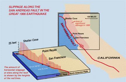
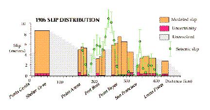
10 STOP #5 POINT REYES PARK HEADQUARTERS AND VISITOR'S CENTER The "Earthquake Trail" along the San Andreas Rift Zone Questions to answer How much offset was there on this trace of the San Andreas fault during the 1906 earthquake? What man-made evidence is there (or was there) for that much offset in 1906? List at least two (2) things. What is the name of the group of rocks on the Pacific Plate side of the San Andreas fault? Name at least three (3) rock types that compose this group of rocks. What is the name of the group of rocks on the North American Plate side of the San Andreas fault?
11 Name at least three (3) types of rocks that compose this group of rocks. Name at least three (3) types of surficial expression of the San Andreas Rift Zone seen here. If you live in San Francisco, what rock types does your apartment/house sit on? If you live somewhere else, what rock type type San Francisco State rest on?
12
13
Geologic Trips San Francisco and the Bay Area
 Excerpt from Geologic Trips San Francisco and the Bay Area by Ted Konigsmark ISBN 0-9661316-4-9 GeoPress All rights reserved. No part of this book may be reproduced without written permission in writing,
Geologic Trips San Francisco and the Bay Area
 Excerpt from Geologic Trips San Francisco and the Bay Area by Ted Konigsmark ISBN 0-9661316-4-9 GeoPress All rights reserved. No part of this book may be reproduced without written permission in writing,
Geology of the Golden Gate National Recreation Area in the Marin Headlands, and Ring Mountain, Tiburon
 Geology of the Golden Gate National Recreation Area in the Marin Headlands, and Ring Mountain, Tiburon May 9, 2006 Field trip guide compiled by Mary Leech Name: Submit this guide with the Subduction lab
Oceanography Field Trip One Key
 Oceanography Field Trip One Key If you are using this key as a make-up guide, you should get a COLOR version of this field trip guide by going to http://www.mpcfaculty.net/alfred_hochstaedter/oceanography.htm
Black Point & Bihler Point
 Black Point & Bihler Point Conglomerate Photo: looking north toward end of Black Point (south of post 1) All of the rocks in this photo are conglomerate. Both Black Point and Bihler Point are formed from
Point Lobos Field Trip 16 May 04
 GES 56Q Monterey Bay Seminar Spring Quarter 2004 Point Lobos Field Trip 16 May 04 Meet at GeoCorner Parking Lot at 0830 Main Objectives for this trip: 1) Intertidal ecology. We will survey the beaches
GEOLOGICAL FEATURES OF THE BADGER SPRINGS TRAIL FOR HIKERS Rev. 3,
 GEOLOGICAL FEATURES OF THE BADGER SPRINGS TRAIL FOR HIKERS Rev. 3, 12-3-02 http://ensayoes.com/docs/176/index-2111121.html Trail location The Badger Springs trail is just a short distance North of the
Point Lobos Field Trip 3 June 06
 GES 56Q Monterey Bay Seminar Spring Quarter 2006 Point Lobos Field Trip 3 June 06 Meet at GeoCorner Parking Lot at 0800 Main Objectives for this trip: 1) Intertidal ecology. The low tide will occur at
Quaternary Processes of the Monterey Bay Area Field Trip Notes
 Quaternary Processes of the Monterey Bay Area Field Trip Notes A color version of this field trip guide, with directions is available at: http://www.mpcfaculty.net/alfred_hochstaedter/geology.htm Click
Maine Geologic Facts and Localities October, Lobster Lake, Maine. Text by Robert G. Marvinney. Maine Geological Survey
 Maine Geologic Facts and Localities October, 1998 Lobster Lake, Maine 45 o 51 7.91 N, 69 o 30 53.88 W Text by Robert G. Marvinney, Department of Agriculture, Conservation & Forestry 1 Map by Introduction
=%REPORT RECONNAISSANCE OF CHISHOLM LAKE PROSPECT. October 25, 1977
 =%REPORT ON FIELD RECONNAISSANCE OF CHISHOLM LAKE PROSPECT October 25, 1977 Bruce D. Vincent Imperial Oil Limited, Minerals - Coal, CALGARY, ALBERTA CHISHOLM LAKE PROSPECT Introduction The Chisholm Lake
transform boundary Photograph by Robert E. Wallace, USGS.
 transform boundary The San Andreas Fault is undoubtedly the most famous transform boundary in the world. To the west of the fault is the Pacific plate, which is moving northwest. To the east is the North
American Institute of Professional Geologists South Dakota Section
 American Institute of Professional Geologists South Dakota Section 2015 Field Trip Guide Deadwood Formation in the Black Hills of South Dakota and Frac Sand Potential Saturday, September 12, 2015 1 Field
Summer 2014 Reading the Geologic History of Doheny State Beach Rodger More LAYERS LET S TAKE A TOUR THE BLUFFS
 Summer 2014 Reading the Geologic History of Doheny State Beach Rodger More DSBIA Board Officer and Geologist (retired) LAYERS of sediment and rock are like a book. Formations make up chapters and individual
Clastic Sedimentary Rocks
 Clastic Sedimentary Rocks Alessandro Grippo, Ph.D. Alternating sandstones and mudstones in Miocene turbidites Camaggiore di Firenzuola, Firenze, Italy Alessandro Grippo review Mechanical weathering creates
Rocks and the Rock Cycle. Banded Iron Formation
 Rocks and the Rock Cycle Banded Iron Formation Rocks Big rocks into pebbles, Pebbles into sand. I really hold a million, million Rocks here in my hand. Florence Parry Heide How do rocks change? How are
Page 1. Name:
 Name: Questions 1 through 3 refer to the following: The diagrams below represent two rock outcrops found several miles apart in New York State. Individual rock layers are lettered, and fossils and rock
Sediment and sedimentary rocks Sediment
 Sediment and sedimentary rocks Sediment From sediments to sedimentary rocks (transportation, deposition, preservation and lithification) Types of sedimentary rocks (clastic, chemical and organic) Sedimentary
Structural Geology Lab. The Objectives are to gain experience
 Geology 2 Structural Geology Lab The Objectives are to gain experience 1. Drawing cross sections from information given on geologic maps. 2. Recognizing folds and naming their parts on stereoscopic air
SCI-5 KES 5.7 Geology Post-test Exam not valid for Paper Pencil Test Sessions
 SCI-5 KES 5.7 Geology Post-test Exam not valid for Paper Pencil Test Sessions [Exam ID:1D5NLH 1 Earth's crust is made of plates that move slowly. This movement changes the appearance of the Earth's crust
Crissy Field Rocks! Crissy Field Center Community Group Programs. A Partnership of: National Park Service. Golden Gate National Parks Conservancy
 Crissy Field Rocks! Crissy Field Center Community Group Programs A Partnership of: National Park Service Golden Gate National Parks Conservancy Presidio Trust 1 Group Leader Pre-Visit Packet Crissy Field
LAB 6: TRINIDAD BEACH FIELD TRIP
 OBJECTIVES: LAB 6: TRINIDAD BEACH FIELD TRIP 1) to develop your powers of observation, especially of geological phenomena; 2) to identify the rocks exposed at Trinidad Beach; 3) to reconstruct some of
depression above scarp scarp
 1 LAB 1: FIELD TRIP TO McKINLEYVILLE AND MOUTH OF THE MAD RIVER OBJECTIVES: a. to look at geomorphic and geologic evidence for large scale thrust-faulting of young sediments in the Humboldt Bay region
Rocks. 3.1 The Rock Cycle. 3.1 The Rock Cycle. 3.1 The Rock Cycle. The Rock Cycle. I. Rocks
 Rocks Tarbuck Lutgens 3.1 The Rock Cycle 3.1 The Rock Cycle I. Rocks Rocks are any solid mass of mineral or mineral-like matter occurring naturally as part of our planet. Types of Rocks 1. Igneous rock
Module 10: Resources and Virginia Geology Topic 4 Content: Virginia Geology Notes
 Virginia is composed of a very diverse landscape that extends from the beaches and barrier islands all of the way to the highly elevated Appalachian Plateau. Geologists have discovered ancient shallow
 UNIT DESCRIPTIONS: Artificial Fill, Undocumented (Afu): Locally derived sandy silt and silty sand, locally with clay and varying amounts of gravel and man-made debris. Abundant concrete rubble, in places
Prentice Hall EARTH SCIENCE
 Prentice Hall EARTH SCIENCE Tarbuck Lutgens Chapter 3 Rocks 3.1 The Rock Cycle Rocks Rocks are any solid mass of mineral or mineral-like matter occurring naturally as part of our planet. Types of Rocks
Module 9 Sedimentary Rocks
 Module 9 Sedimentary Rocks SEDIMENTARY ROCKS Rocks formed from material derived from preexisting rocks by surfacial processes followed by diagenesis There are two main classes of sedimentary rocks Clastic
Geology (Mellow) Hike, Santa Lucia Memorial Park February 16, I. Overview of Santa Lucia Range geology and tectonic history
 Hike, Santa Lucia Memorial Park February 16, I. Overview of Santa Lucia Range geology and tectonic history") Geology (Mellow) Hike, Santa Lucia Memorial Park February 16, 2015 I. Overview of Santa Lucia Range geology and tectonic history A. Basement Rocks 1. Salinian Block Rocks Sierra Nevada Type, continental
Geology (Mellow) Hike, Santa Lucia Memorial Park February 16, 2015 I. Overview of Santa Lucia Range geology and tectonic history A. Basement Rocks 1. Salinian Block Rocks Sierra Nevada Type, continental
Rocks don't form into the three types of rocks and stay there. The Earth is constantly changing and in motion. The rock cycle demonstrates how a rock
 Rocks don't form into the three types of rocks and stay there. The Earth is constantly changing and in motion. The rock cycle demonstrates how a rock can start out as one type and change into another.
Earth s Changing Surface
 Earth s Changing Surface Fourth grade scientists are introduced to the scope of geologic time and learn about forces that change our Earth s surface. During their study, students use scientific modeling
Geology 12 FINAL EXAM PREP. Possible Written Response Exam Questions
 Geology 12 FINAL EXAM PREP Possible Written Response Exam Questions Use this study guide to prepare for the written response portion of the final exam. Name FINAL EXAM - POSSIBLE WRITTEN RESPONSE QUESTIONS
Sediment. Weathering: mechanical and chemical decomposition and disintegration of rock and minerals at the surface
 Sediment Some basic terminology Weathering: mechanical and chemical decomposition and disintegration of rock and minerals at the surface Erosion: removal of weathered rock and minerals from one place to
A Brief Review of the Geology of Monhegan Island, Maine
 Maine Geologic Facts and Localities April, 2010 A Brief Review of the Geology of Monhegan Island, Maine 43 45 58.95 N, 69 18 47.45 W Text by R. G. Marvinney, Department of Agriculture, Conservation & Forestry
L.O: SLOWING STREAMS DEPOSIT (SORT) SEDIMENT HORIZONTALLY BY SIZE.
 SEDIMENT HORIZONTALLY BY SIZE.") L.O: SLOWING STREAMS DEPOSIT (SORT) SEDIMENT HORIZONTALLY BY SIZE. 1. Base your answer to the following question on the profile shown below, which shows the pattern of horizontal sorting produced at a
L.O: SLOWING STREAMS DEPOSIT (SORT) SEDIMENT HORIZONTALLY BY SIZE. 1. Base your answer to the following question on the profile shown below, which shows the pattern of horizontal sorting produced at a
As compaction and cementation of these sediments eventually occur, which area will become siltstone? A) A B) B C) C D) D
 A B) B C) C D) D") 1. A student obtains a cup of quartz sand from a beach. A saltwater solution is poured into the sand and allowed to evaporate. The mineral residue from the saltwater solution cements the sand grains together,
1. A student obtains a cup of quartz sand from a beach. A saltwater solution is poured into the sand and allowed to evaporate. The mineral residue from the saltwater solution cements the sand grains together,
GIFFORD PINCHOT STATE PARK DIABASE (MOLTEN LIQUID ROCK)
") PENNSYLVANIA TRAIL OF GEOLOGY PARK GUIDE 10 GIFFORD PINCHOT STATE PARK DIABASE (MOLTEN LIQUID ROCK) Gifford Pinchot State Park contains examples of the three major rock classes: igneous, metamorphic, and
PENNSYLVANIA TRAIL OF GEOLOGY PARK GUIDE 10 GIFFORD PINCHOT STATE PARK DIABASE (MOLTEN LIQUID ROCK) Gifford Pinchot State Park contains examples of the three major rock classes: igneous, metamorphic, and
Rock Cycle. Draw the Rock cycle on your remediation page OR use a sheet of notebook paper and staple
 Earth Science Test 8.ESS2.3) Describe the relationship between the processes and forces that create igneous, sedimentary, and metamorphic rocks. I can develop and use models to explain how plate movements
Sediment and Sedimentary rock
 Sediment and Sedimentary rock Sediment: An accumulation of loose mineral grains, such as boulders, pebbles, sand, silt or mud, which are not cemented together. Mechanical and chemical weathering produces
Sandy Point Beach, Cousins Island, Yarmouth, Maine
 Maine Geologic Facts and Localities April, 2008 Sandy Point Beach, Cousins Island, Yarmouth, Maine 43 o 46 25.46 N, 70 o 8 44.84 W Text by Tom Weddle, Department of Agriculture, Conservation & Forestry
Sedimentary Rocks Most common SURFACE rock
 Sedimentary Rocks Most common SURFACE rock Formation of Sedimentary Rocks (Sediments are pressed & cemented together) Weathering, Erosion, and Deposition Erosion involves the weathering and the removal
The Geology of Sebago Lake State Park
 Maine Geologic Facts and Localities September, 2002 43 55 17.46 N, 70 34 13.07 W Text by Robert Johnston, Department of Agriculture, Conservation & Forestry 1 Map by Robert Johnston Introduction Sebago
Plate Tectonics Tutoiral. Questions. Teacher: Mrs. Zimmerman. Plate Tectonics and Mountains Practice Test
 Teacher: Mrs. Zimmerman Print Close Plate Tectonics and Mountains Practice Test Plate Tectonics Tutoiral URL: http://www.hartrao.ac.za/geodesy/tectonics.html Questions 1. Fossils of organisms that lived
Beneath our Feet: The 4 Layers of the Earty by Kelly Hashway
 Beneath our Feet: The 4 Layers of the Earty by Kelly Hashway The Earth is more than a giant ball made up of dirt, rocks, and minerals. The Earth may look like a giant ball from when looking at it from
LAB 2 IDENTIFYING MATERIALS FOR MAKING SOILS: ROCK AND PARENT MATERIALS
 LAB 2 IDENTIFYING MATERIALS FOR MAKING SOILS: ROCK AND PARENT MATERIALS Learning outcomes The student is able to: 1. understand and identify rocks 2. understand and identify parent materials 3. recognize
The Rocky Road Game. Sedimentary Rock. Igneous Rock. Start. Metamorphic Rock. Finish. Zone of Transportation. Weathering Way.
 Sedimentary Rock Deposition Depot Zone of Transportation Transported: Advance 3 Weathering Way The Rocky Road Game Uplift: Advance 5 Lithification Lane Crystallization Crossway Submerge Detour take the
The Rock Cycle The Rock Cycle illustrates the origin of igneous, sedimentary and metamorphic rocks
 The Rock Cycle The Rock Cycle illustrates the origin of igneous, sedimentary and metamorphic rocks Igneous rocks form as molten magma or lava cools and solidifies. Magma is completely or partly molten
The Nature of Sedimentary Rocks
 The Nature of Sedimentary Rocks Sedimentary rocks are composed of: Fragments of other rocks Chemical precipitates Organic matter or biochemically produced materials The Nature of Sedimentary Rocks Sedimentary
LAB - Rock Classification
 NAME: LAB - Rock Classification Date: Introduction: A rock is any naturally occurring aggregate of minerals, mineral-like solids, glass, or organic particles. The properties that can be observed in a rock
EPS 50 Lab 4: Sedimentary Rocks
 Name: EPS 50 Lab 4: Sedimentary Rocks Grotzinger and Jordan, Chapter 5 Introduction In this lab we will classify sedimentary rocks and investigate the relationship between environmental conditions and
Sediments and. Sedimentary Rocks
 Sediments and Sedimentary Rocks Bottom Line Sedimentary rocks form from particles accumulated in sedimentary layers Sedimentary layers can be formed by clastic or detrital particles (e.g., sand grains,
B) color B) Sediment must be compacted and cemented before it can change to sedimentary rock. D) igneous, metamorphic, and sedimentary rocks
 color B) Sediment must be compacted and cemented before it can change to sedimentary rock. D) igneous, metamorphic, and sedimentary rocks") 1. Which characteristic of nonsedimentary rocks would provide the least evidence about the environment in which the rocks were formed? A) structure B) color C) crystal size D) mineral composition 2. Which
1. Which characteristic of nonsedimentary rocks would provide the least evidence about the environment in which the rocks were formed? A) structure B) color C) crystal size D) mineral composition 2. Which
Sedimentary Structures in Metamorphic Rocks
 Maine Geologic Facts and Localities November, 2006 Primary Sedimentary Structures in Some Metamorphic Rocks Text by Thomas K. Weddle, Department of Agriculture, Conservation & Forestry 1 Photo by Thomas
Rocks and The Rock Cycle
 Rocks and The Rock Cycle 3 Main Rock Types Igneous Sedimentary Metamorphic 3 Main Rock Types Igneous Sedimentary Metamorphic Igneous EXTRUSIVE Forms when lava cools quickly on the Earths surface Forms
Glacial Geology of Moose Point State Park, ME
 Geologic Site of the Month May, 2013 Glacial Geology of Moose Point State Park, Maine 44 o 25 59.18"N, 68 o 56 37.11"W Text and photos by Woodrow B. Thompson, Department of Agriculture, Conservation &
A Geological Tour of Tumbledown Mountain, Maine
 Maine Geologic Facts and Localities April, 1998 A Geological Tour of Tumbledown Mountain, Maine 44 45 3.21 N, 70 32 50.24 W Text by Robert G. Marvinney, Department of Agriculture, Conservation & Forestry
Igneous Rocks. Sedimentary Rocks
 Earth Sciences 083F Plate Tectonics Exercises Plate tectonics is a model for the dynamic behaviour of Earth s lithosphere. Outlining stable areas of lithosphere are narrow zones (plate boundaries) in which
Rocks and The Rock Cycle
 Rocks and The Rock Cycle 3 Main Rock Types Igneous Sedimentary Metamorphic 3 Main Rock Types Igneous Sedimentary Metamorphic Igneous EXTRUSIVE Forms when lava cools quickly on the Earths surface Forms
Geology 252, Historical Geology, California State University, Los Angeles - professor: Dr. Alessandro Grippo
 LAB # 1 - CLASTIC ROCKS Background: - Mechanical and Chemical Weathering - Production of Clastic Sediment - Classification of Sediment according to size: Gravel, Sand, Silt, Clay - Erosion, Transportation
The Geology of Two Lights State Park. Cape Elizabeth, Maine
 Maine Geologic Facts and Localities June, 2002 Cape Elizabeth, Maine 43 33 33.48 N, 70 12 13.32 W Text by Henry N. Berry IV and Robert G. Marvinney, Department of Agriculture, Conservation & Forestry 1
Topic 12: Dynamic Earth Pracatice
 Name: Topic 12: Dynamic Earth Pracatice 1. Earth s outer core is best inferred to be A) liquid, with an average density of approximately 4 g/cm 3 B) liquid, with an average density of approximately 11
Sedimentary rocks. Mechanical Weathering. Weathering. Chemical weathering. Rates of weathering. Fossil Fuel Resources. Two kinds of weathering
 Sedimentary rocks Fossil Fuel Resources Exam next Tuesday February 14 Bring Scantron and Review Questions About 75% of all rock outcrops on the continents Important to reconstruct much of Earth's history
Lab 7: Sedimentary Structures
 Name: Lab 7: Sedimentary Structures Sedimentary rocks account for a negligibly small fraction of Earth s mass, yet they are commonly encountered because the processes that form them are ubiquitous in the
ENVI.2030L Geologic Time
 Name ENVI.2030L Geologic Time I. Introduction There are two types of geologic time, relative and absolute. In the case of relative time geologic events are arranged in their order of occurrence. No attempt
THE STRUCTURE AND THICKNESS OF THE CLINTON AND BEREA FORMATIONS IN THE VICINITY OF WOOSTER, OHIO
 THE STRUCTURE AND THICKNESS OF THE CLINTON AND BEREA FORMATIONS IN THE VICINITY OF WOOSTER, OHIO KARL VER STEEG College of Wooster INTRODUCTION AND ACKNOWLEDGMENTS The data used in the construction of
Rock Identification. invisible rhyolite andesite basalt komatiite. visible granite diorite gabbro peridotite
 Rock Identification The samples in this lab are arranged into four groups: igneous, sedimentary, metamorphic, and unknown. Study the igneous, sedimentary, and metamorphic collections to get an idea of
The Ovens, Bar Harbor, Maine
 Maine Geologic Facts and Localities July, 2003 The Ovens, Bar Harbor, Maine 44 26 15.65 N, 68 15 51.80 W Text by Henry Berry, Department of Agriculture, Conservation & Forestry 1 Postcard courtesy of Wally
A) B) C) D) 4. Which diagram below best represents the pattern of magnetic orientation in the seafloor on the west (left) side of the ocean ridge?
 B) C) D) 4. Which diagram below best represents the pattern of magnetic orientation in the seafloor on the west (left) side of the ocean ridge?") 1. Crustal formation, which may cause the widening of an ocean, is most likely occurring at the boundary between the A) African Plate and the Eurasian Plate B) Pacific Plate and the Philippine Plate C)
1. Crustal formation, which may cause the widening of an ocean, is most likely occurring at the boundary between the A) African Plate and the Eurasian Plate B) Pacific Plate and the Philippine Plate C)
The Marine Environment
 The Marine Environment SECTION 16.1 Shoreline Features In your textbook, read about erosional landforms, beaches, estuaries, longshore currents, and rip currents. For each statement below, write or. 1.
Chapter 6 Pages of Earth s Past: Sedimentary Rocks
 Chapter 6 Pages of Earth s Past: Sedimentary Rocks Introduction! Drilling into the bottom of the North Sea, we encounter: " Soft mud and loose sand, silt, pebbles, and shells. Then: " Similar materials
Geology 229 Engineering Geology. Lecture 6. Basic Rock Classification and Engineering Considerations (West, Chs. 2, 3, 4, 5)
") Geology 229 Engineering Geology Lecture 6 Basic Rock Classification and Engineering Considerations (West, Chs. 2, 3, 4, 5) Outline of this Lecture 1. Rock types and rock cycle 2. Geological and engineering
Geology 229 Engineering Geology Lecture 6 Basic Rock Classification and Engineering Considerations (West, Chs. 2, 3, 4, 5) Outline of this Lecture 1. Rock types and rock cycle 2. Geological and engineering
Geologic Trips San Francisco and the Bay Area
 Excerpt from Geologic Trips San Francisco and the Bay Area by Ted Konigsmark ISBN 0-9661316-4-9 GeoPress All rights reserved. No part of this book may be reproduced without written permission in writing,
Continental Drift Discussion Questions:
 Continental Drift Discussion Questions: 1) What are tectonic plates? 2) What happens at the boundaries between these plates? 3) What are fault lines? 4) What effect has Continental Drift had on the shape
2 Igneous Rock. How do igneous rocks form? What factors affect the texture of igneous rock? BEFORE YOU READ. Rocks: Mineral Mixtures
 CHAPTER 2 2 Igneous Rock SECTION Rocks: Mineral Mixtures BEFORE YOU READ After you read this section, you should be able to answer these questions: How do igneous rocks form? What factors affect the texture
FIREPLACE GEOLOGY. Dining Hall
 FIREPLACE GEOLOGY Dining Hall The Dining Hall fireplace represents a slice through a Cascade Mountain volcano. Volcanoes are formed from molten magma rising up from within the Earth s crust. Magma that
Sedimentary Rocks. Origin, Properties and Identification. Physical Geology GEOL 100. Ray Rector - Instructor
 Sedimentary Rocks Origin, Properties and Identification Physical Geology GEOL 100 Ray Rector - Instructor Sedimentary Rock Origin and Identification Lab Pre-Lab Internet Link Resources 1) http://www.rockhounds.com/rockshop/rockkey/index.html
Structural Geology Lab. The Objectives are to gain experience
 Geology 2 Structural Geology Lab The Objectives are to gain experience 1. Drawing cross sections from information given on geologic maps. 2. Recognizing folds and naming their parts on stereoscopic air
GEOL.3250 Geology for Engineers Sedimentary & Metamorphic Rocks
 GEOL.3250 Geology for Engineers Sedimentary & Metamorphic Rocks Name I. Introduction The bulk of the earth's crust is composed of relatively few minerals. These can be mixed together, however, to give
TAKE HOME EXAM 8R - Geology
 Name Period Date TAKE HOME EXAM 8R - Geology PART 1 - Multiple Choice 1. A volcanic cone made up of alternating layers of lava and rock particles is a cone. a. cinder b. lava c. shield d. composite 2.
Practice Test Rocks and Minerals. Name. Page 1
 Name Practice Test Rocks and Minerals 1. Which rock would be the best source of the mineral garnet? A) basalt B) limestone C) schist D) slate 2. Which mineral is mined for its iron content? A) hematite
Sedimentology & Stratigraphy. Thanks to Rob Viens for slides
 Sedimentology & Stratigraphy Thanks to Rob Viens for slides Sedimentology The study of the processes that erode, transport and deposit sediments Sedimentary Petrology The study of the characteristics and
1. Base your answer to the following question on The diagram below represents a part of the crystal structure of the mineral kaolinite.
 1. Base your answer to the following question on The diagram below represents a part of the crystal structure of the mineral kaolinite. An arrangement of atoms such as the one shown in the diagram determines
Name Class Date. Chapter 3 Rocks Chapter Test. Write the letter that best answers the question or completes the statement on the line provided.
 Chapter 3 Rocks Chapter Test Multiple Choice Write the letter that best answers the question or completes the statement on the line provided. 1. Which of the following is true about rocks? a. Rocks are
Sedimentary Rocks. Weathering. Mechanical & Chemical Weathering. Sediments. Lithification. Deposition. Transport. Erosion.
 Lithification Sedimentary Rocks Sediments Deposition Transport Erosion Weathering Weathering The sediments that make up sedimentary rocks are produced by: Mechanical & Chemical Weathering Mechanical Weathering
Geology 15 West Valley College. Exam IV: Sierra Nevada
 Geology 15 West Valley College Name Exam IV: Sierra Nevada 1) On the diagram above, where is the Arc- Trench Gap? a. 1 and 3 c. 7 and 8 d. 6 e. 5 and 10 2) On the diagram above, where is the subduction
Figure 1 The map shows the top view of a meandering stream as it enters a lake. At which points along the stream are erosion and deposition dominant?
 1. In which type of climate does chemical weathering usually occur most rapidly? 1. hot and dry 3. cold and dry 2. hot and wet 4. cold and wet 2. Figure 1 The map shows the top view of a meandering stream
Lecture Outline Wednesday - Friday February 14-16, 2018
 Lecture Outline Wednesday - Friday February 14-16, 2018 Quiz 2 scheduled for Friday Feb 23 (Interlude B, Chapters 6,7) Questions? Chapter 6 Pages of the Past: Sedimentary Rocks Key Points for today Be
A. IGNEOUS Rocks formed by cooling and hardening of hot molten rock called magma (within crust or at its surface).
.") EARTH SCIENCE 11 CHAPTER 5 NOTES KEY How Earth's Rocks Were Formed Early geologists believed that the physical features of the Earth were formed by sudden spectacular events called CATASTROPHES. Modern
EARTH SCIENCE 11 CHAPTER 5 NOTES KEY How Earth's Rocks Were Formed Early geologists believed that the physical features of the Earth were formed by sudden spectacular events called CATASTROPHES. Modern
The Rock Cycle & Plate Tectonics
 The Rock Cycle & Plate Tectonics I. The Rock Cycle 1. Rocks are the most common material on Earth. 2. They are made up of one or more minerals. A. The rock cycle explains how Earth processes change a rock
Hiking the Bold Coast, Cutler, Maine
 Maine Geologic Facts and Localities June, 2010 Hiking the Bold Coast, Cutler, Maine 44 o 39 36.34 N, 67 o 12 46.99 W Text by Robert A. Johnston, Department of Agriculture, Conservation & Forestry 1 Map
Name. 4. The diagram below shows a soil profile formed in an area of granite bedrock. Four different soil horizons, A, B, C, and D, are shown.
 Name 1. In the cross section of the hill shown below, which rock units are probably most resistant to weathering? 4. The diagram below shows a soil profile formed in an area of granite bedrock. Four different
The Marine Environment
 The Marine Environment SECTION 16.1 Shoreline Features In your textbook, read about erosional landforms, beaches, estuaries, longshore currents, and rip currents. For each statement below, write true or
Figure 1. Random orientation of crystal grains in an igneous rock, granite.
 ES088 The Earth s Crust: Rocks Earth system forensics might well start with a disciplined look at materials and how they are formed. When you are given a piece of rock, it is important to remember that
L wave Lahar Lava Magma
 Very large collapsed volcanic crater, often containing a lake eg. Lake Taupo The process which provides the force to move the tectonic plates Innermost part of the Earth, made of a liquid outer core and
THE ROCK CYCLE & ROCKS. Subtitle
 THE ROCK CYCLE & ROCKS Subtitle 3. Three rocks that do not have minerals or are composed of nonmineral matter. Coal Pumuce Obsidian THE ROCK CYCLE Why do scientists study rocks? Rocks contain clues about
Today we will discuss places mobility Natural disasters lead to California s beauty Aesthenosphere
 Agenda 2. Geologic History Today we will discuss What Physical Geography is Brief geologic history of California Geography 106 California Geography M. Pesses Antelope Valley College Physical Geographers
sonar seismic wave basalt granite
 geologist sonar crust geology seismic wave mantle constructive force basalt inner core destructive force granite outer core The solid, rocky, surface layer of the earth. an instrument that can find objects
Rock Star 101. Introduction to Rocks.
 Rock Star 101 Introduction to Rocks www.mineralsed.ca Lesson 1: Rocks are made of minerals. Element, Mineral, Rock, Outcrop Lesson 2: Rock formation is cyclic. Lesson 3: Igneous rocks crystallize from
Cretaceous, Dakota Formation, Terra Cotta Member South Side of I-70, Salina County, Kansas
 Cretaceous, Dakota Formation, Terra Cotta Member South Side of I-70, Salina County, Kansas Written By: Steven D.J. Baumann G-102010-1A Outcrop looking southeast Photo taken by: Steven Baumann on 10-20-2010