BRAZILIAN SOUTHERN MARGIN: AN EXAMPLE OF THE IDENTIFICATION OF THE BASE OF THE SLOPE ON A PASSIVE CONTINENTAL MARGIN
|
|
|
- Erin King
- 5 years ago
- Views:
Transcription
1 BRAZILIAN SOUTHERN MARGIN: AN EXAMPLE OF THE IDENTIFICATION OF THE BASE OF THE SLOPE ON A PASSIVE CONTINENTAL MARGIN Luiz Carlos Torres Brazilian Navy Hydrographic Center Izabel King Jeck Brazilian Navy Hydrographic Center Ana Angélica Ligiéro Alberoni Brazilian Navy Hydrographic Center Héli H i Vill Hélio Heringer Villena University of the State of Rio de Janeiro
2 Introduction UNCLOS, Article 76th... in absence of the evidence to the contrary, the foot of the slope shall be determined as the point of maximum change in the gradient in its base. Scientific and Technical Guidelines, The Commission interprets the determination of the foot of the continental slope by means of the point of maximum change in gradient at is base, as a PROVISION WITH THE CHARACTER OF GENERAL RULE. The fundamental requirement posed by this provision ii are: - The identification of the region defined as the base of the continental slope; and - The determination of the location of the point of maximum change in the gradient at the base of the continental slope.
3 Purposes: The identification of the base of the slope in Brazilian Continental Southern Margin (BCSM) An exercise by the determination of foot of slope invoking evidence to the contrary. Brazilian efforts in order to contribute for the implementation of the UNCLOS Article 76, and
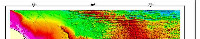
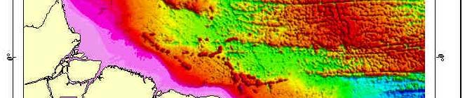
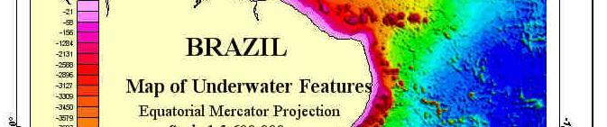

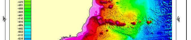

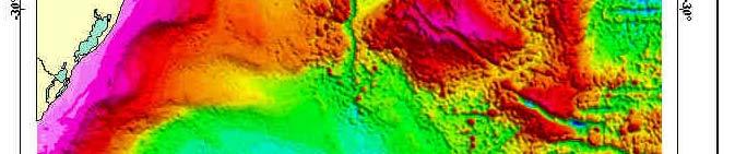
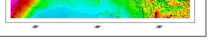
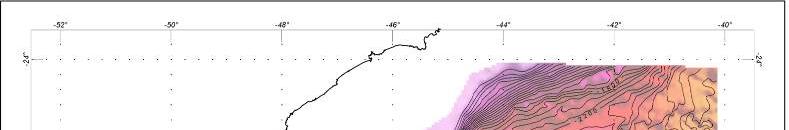
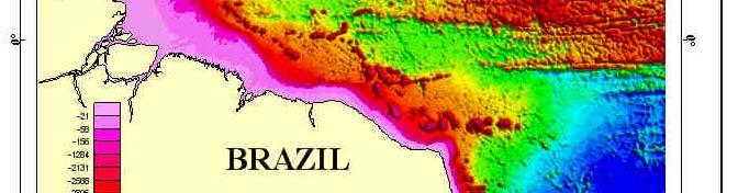
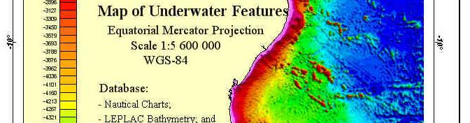
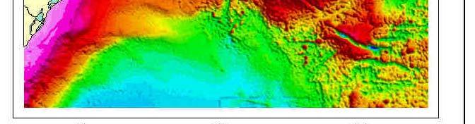
4 Brazilian Continental Margin Map of Underwater Features

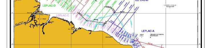
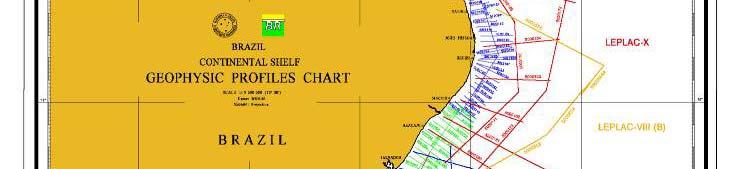
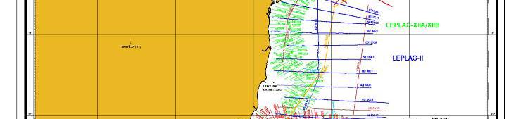
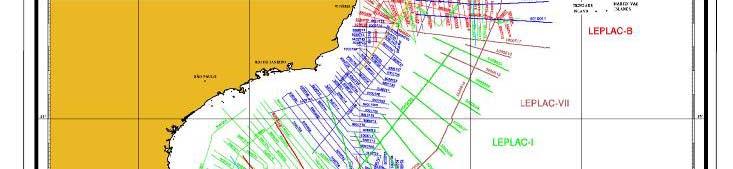
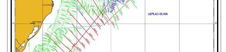
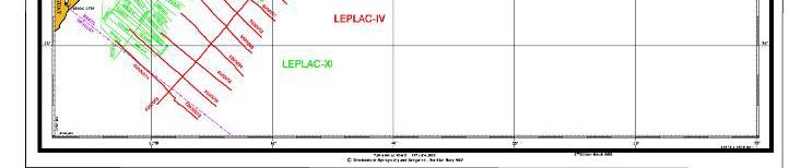
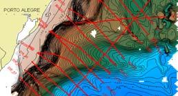
5 Map of Brazilian Continental Shelf Project Geophysical Profiles
6 Geoeophysical Data Carried Out On Brazilian Continental Margin Geophysical data Length (km) Seismic multichannel * Bathymetry** Gravity Magnetometry
7 The Base of the Slope in Brazilian Southern Margin The base of the continental slope was identified and defined in accordance with the Scientific and Technical Guidelines section 5, specially in the following paragraphs: The Commission defines the base of the continental slope as a region where the lower part of the slope merges into the top of the CONTINENTAL RISE, or it into the top of the DEEP OCEAN FLOOR WHERE A CONTINENTAL RISE DOES NOT EXIST.... First, the search for its seaward edge should start from the rise, or from the deep ocean floor where a rise is not developed, in a direction towards the continental slope. Secondly, the search for its landward edge should start from the lower part of the slope in the direction of the CONTINENTAL RISE, or the DEEP OCEAN FLOOR WHERE A RISE IS NOT DEVELOPED.

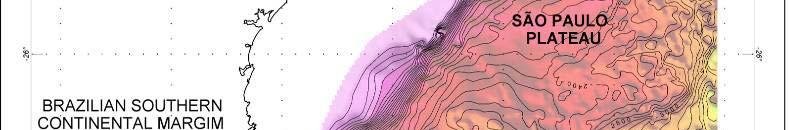
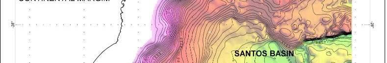
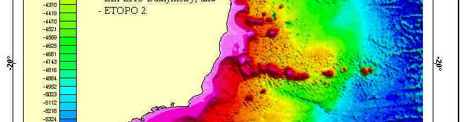
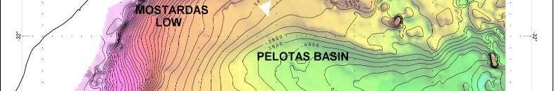
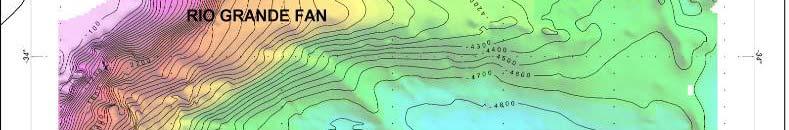
8 Major Underwater features of the BCSM


")
9 Gradient Map as tool to support the region defined as the Base of the Slope (BOS)
10 The Base of the Slope in Brazilian Southern Margin The base of the continental slope was identified and defined in accordance with the Scientific and Technical Guidelines section 5, specially in the following paragraphs: As a general rule, whenever the base of the continental slope can be clearly l dt determined don the basis of morphological hl land bth bathymetric ti evidence, the Commission recommends the application of that evidence. GEOLOGICAL AND GEOPHYSICAL data can also be submitted by Coastal State TO SUPPLEMENT PROOF THAT THE BASE OF THE CONTINENTAL SLOPE IS FOUND AT THAT LOCATION.

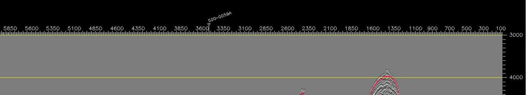
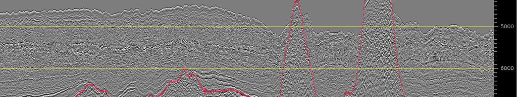
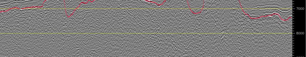
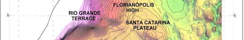
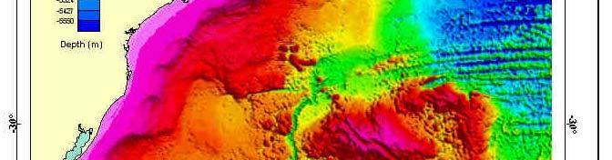
11 SANTA CATARINA PLATEAU CONTINENTAL DEPOSITS INTERPRETED BASEMENT FOS Continental Deposits
12 Determitation of the Foot of Slope UNCLOS, Article 76th... in absence of the evidence to the contrary, the foot of the slope shall be determined as the point of maximum change in the gradient in its base. Scientific and Technical Guidelines, The Commission interprets the determination of the foot of the continental slope by means of the point of maximum change in gradient at is base, as a PROVISION WITH THE CHARACTER OF GENERAL RULE. The fundamental requirement posed by this provision ii are: - The identification of the region defined as the base of the continental slope; and - The determination of the location of the point of maximum change in the gradient at the base of the continental slope.
13
14 Foot of Slope plotting over Gradient Map
15 Dt Determitation itti of fth the Foot of fsl Slope UNCLOS, Article 76th... in absence of the evidence to the contrary, the foot of the slope shall be determined as the point of maximum change in the gradient in its base.
16 The Foot of Slope by Means of Evidence to the Contrary BORE HOLE Anomalia Bouguer Escala 1: (metros) WGS 84 / *Eq.Mercator The Borehole Plotted over Bouguer Gravity Map Map constructed from public domain database
17 -20 Final Results The Foot of Slope and Borehole plotted over Bouguer Gravity Map - BORE HOLE - FOS Anomalia Bouguer Escala 1: (metros) WGS 84 / *Eq.Mercator Map constructed from public domain database
18 Final Results The Foot of Slope and Borehole Plotted over Gradient Map Map constructed from public domain database.
19 Final Results cob Profiles derived from the grid: Red line - bathymetry, Green line - gradient of bathymetry, y, Blue line - free air gravity and Purple line - Bouguer gravity. The current profile is in the vicinity of Brazil and Uruguay Lateral Maritime Boundary.
20 Final Remarks BOS - sensible interpretation for the implementation of the UNCLOS Article 76 Gradient Map - points out as a useful aids in terms of identification of the regional base of the slope. The application of tools which measures seabed gradient may be take into consideration i that the characteristics i of development of margin. Usually margin developed under huge continental sedimentation presents smooth gradient if compared with hungry continental sedimentation margin, where, usually, presents sharp variations on seabed gradient. Typical parameters (break of geological shelf, slope and continental elevation) adjusted for a specific margin, not necessarily, will present the same adjustment when applicable on another margin. BOS -geomorphologic hl approach would be improved if integrated with ihadditional i geological and geophysical evidences. The determination of the foot of slope by means of maximum m change of gradient in its base points out as the most advantageous method in this region.
21 Acknowledgements The authors would like to express the deepest thankfulness to: The members of the Brazilian Continental Shelf Project who have had remarkable involvement in the material presented in this paper, and GEOSOFT Latinoamérica Ltda, which sponsored Dr Hélio Heringer Villena in order toattendtt 5 th ABLOS Conference.
22 Thank you!!!!!!!!!!!!!!!!!!!!!!!
23 References Burgos, M.R, Numerical methods for determining the outer limit of the juridical continental shelf of a coastal State. CIRM, Continental Shelf and UNCLOS Article 76. Brazilian Submission. Executive Sumary (8p). Available on: p _ new/submissions_ files/submission_ bra.htm CIRM, The Brazilian submission to the Commission on the Limits of the Continental Shelf pursuant to article 76 of the United Nations Convention on the Law of the Sea. Addendum to the Executive Summary dated 17 May 2004 (18 p.). Available on: GEOSOFT Oasis montaj, available on: Gorini, M.A.V Geomorphometric characterization of the foot of the continental slope in passive continental margins. X Congresso Internacional da Sociedade Brasileira de Geofísica. Heezen, B.C., Tharp, M. and Ewing, M., The floor of the oceans, 1:The North Atlantic. New York, The Geological Society of America Special Paper 65, 122p. Russo, L. R., LEPLAC: Isópacas de sedimentos e profundidade do embasamento na margem continental brasileira. VI Congresso Internacional da Sociedade Brasileira de Geofísica (6 CISBGf), Rio de Janeiro-RJ, 4 p. Scientific and Technical Guidelines United Nations Convention on The Law of The Sea Commission on the Limits of the Continental Shelf New York, NY, USA, 13th MAY Torres, L.C., Jeck, I.K., Alberoni, A.A.L, BREHME, I., Tópicos sobre Metodologias Passíveis para A Determinação do Pé do Talude Continental Conforme a Convenção das Nações Unidas sobre o Direito do Mar. VII International Congress of the Brazilian Geophysical Society, Salvador, Bahia, Brazil. Torres, L.C., Villena, H.H., Barreira, L.M., Santos, D.I., Rangel, A.A Base de Dados Batimétricos do Atlântico Sul. XXI Congresso Brasileiro de Cartografia. Belo Horizonte, MG. Anais do Congresso. UNCLOS - United Nations Convention on the Law of the Sea, United Nations, New York, United States of America, 294p.
HOW TO DEFINE THE BASE OF THE SLOPE IN LOW GRADIENT PASSIVE MARGINS? BRAZILIAN CONTINENTAL SHELF PROJECT (LEPLAC)
") HOW TO DEFINE THE 1 BASE OF THE SLOPE IN LOW GRADIENT PASSIVE MARGINS? BRAZILIAN CONTINENTAL SHELF PROJECT (LEPLAC) Izabel King Jeck Commander, DHN, Brazilian Navy izabel@dhn.mar.mil.br How to apply art.76
HOW TO DEFINE THE 1 BASE OF THE SLOPE IN LOW GRADIENT PASSIVE MARGINS? BRAZILIAN CONTINENTAL SHELF PROJECT (LEPLAC) Izabel King Jeck Commander, DHN, Brazilian Navy izabel@dhn.mar.mil.br How to apply art.76
Author 1: Luiz Carlos, TORRES, BRAZILIAN FEMAR - Fundação de Estudos do Mar
 Norte Brasileira Ridge System, an example of natural component or natural prolongation of the Brazilian Continental Margin? Author 1: Luiz Carlos, TORRES, BRAZILIAN FEMAR - Fundação de Estudos do Mar torres.luizcarlos@gmail.com
UNCLOS Article 76- Formulae and constraint lines
 UNCLOS Article 76- Formulae and constraint lines Dr Lindsay Parson (UNCLOS Group, National Oceanography Centre, UK) ABLOS TUTORIAL SESSION - Article 76 of UNCLOS 10th October 2005 IHO/IAG/IOC Advisory
CONTINENTAL SHELF SUBMISSION OF ANGOLA - EXECUTIVE SUMMARY -
 CONTINENTAL SHELF SUBMISSION OF ANGOLA - EXECUTIVE SUMMARY - INDEX List of Figures 2 List of Tables 3 1 Introduction 5 2 Provisions of Article 76 7 3 Angolan Institutions responsible for the Submission
MAPS AND COORDINATES...
 Table of Contents 1 INTRODUCTION... 2 2 MAPS AND COORDINATES... 3 3 ADVISORY ASSISTANCE FROM COMMISSION MEMBERS... 3 4 PROVISIONS OF ARTICLE 76 INVOKED... 3 5 OUTSTANDING MARITIME DELIMITATIONS... 4 6
The french national programme for claiming continental shelf beyond 200 Miles
 The french national programme for claiming continental shelf beyond 200 Miles Using global bathymetric models in the context of an Extended Continental Shelf submission EXTRAPLAC Using Global Bathymetric
IRELAND. PART I Executive Summary
 IRELAND Submission to the Commission on the Limits of the Continental Shelf pursuant to Article 76, paragraph 8 of the United Nations Convention on the Law of the Sea 1982 in respect of the area abutting
EXECUTIVE SUMMARY A SUBMISSION OF DATA AND INFORMATION ON THE OUTER LIMITS OF THE CONTINENTAL SHELF OF THE REPUBLIC OF NIGERIA PURSUANT TO
 EXECUTIVE SUMMARY A SUBMISSION OF DATA AND INFORMATION ON THE OUTER LIMITS OF THE CONTINENTAL SHELF OF THE REPUBLIC OF NIGERIA PURSUANT TO PART VI OF AND ANNEX II TO THE UNITED NATIONS CONVENTION ON THE
Article 76, variations in annotation and implementation seen in submission documents for the claim of Extended Continental Shelf
 Article 76, variations in annotation and implementation seen in submission documents for the claim of Extended Continental Shelf Mr. Shin Tani Chairman, IHO/IAG Advisory Board on the Law of the Sea (ABLOS)
FOOT OF THE CONTINENTAL SLOPE IN ARTICLE 76
 FOOT OF THE CONTINENTAL SLOPE IN ARTICLE 76 Vaughan Stagpoole, Institute of Geological & Nuclear Sciences, Lower Hutt, New Zealand, v.stagpoole@gns.cri.nz Ray Wood, Institute of Geological & Nuclear Sciences,
Does Ascension Island have an outer continental shelf?
 Does Ascension Island have an outer continental shelf? Robin Cleverly UK Hydrographic Office Lindsay Parson NOC, Southampton (with Alan Evans, Peter Hunter, Rosemary Edwards of NOC and Chris Carleton of
OUTER CONTINENTAL SHELF CLAIMS IN THE ARCTIC. Presentation given by Dr. Kamrul Hossain ASA University Bangladesh 15 March 2010
 OUTER CONTINENTAL SHELF CLAIMS IN THE ARCTIC Presentation given by Dr. Kamrul Hossain ASA University Bangladesh 15 March 2010 Contents Historical background of the continental shelf Concept of continental
JOINT SUBMISSION TO THE COMMISSION ON THE LIMITS OF THE CONTINENTAL SHELF BY TUVALU, THE REPUBLIC OF FRANCE AND NEW ZEALAND (TOKELAU)
") JOINT SUBMISSION TO THE COMMISSION ON THE LIMITS OF THE CONTINENTAL SHELF BY TUVALU, THE REPUBLIC OF FRANCE AND NEW ZEALAND (TOKELAU) TABLE OF CONTENTS i. PREFACE... iii ii. LIST OF FIGURES... iv iii.
JOINT SUBMISSION TO THE COMMISSION ON THE LIMITS OF THE CONTINENTAL SHELF BY TUVALU, THE REPUBLIC OF FRANCE AND NEW ZEALAND (TOKELAU) TABLE OF CONTENTS i. PREFACE... iii ii. LIST OF FIGURES... iv iii.
CONFERENCE OF PARLIAMENTARIANS OF THE ARCTIC REGION. UN LOS Convention and the extended continental shelf in the Arctic
 CONFERENCE OF PARLIAMENTARIANS OF THE ARCTIC REGION UN LOS Convention and the extended continental shelf in the Arctic Presentation given by Dr. Kamrul Hossain Finnish Parliament 18 November 2009 Contents
Introduction After reviewing the classification of continental margins (not plate margins) in your textbook, answer the following questions:
 in your textbook, answer the following questions:") Investigating the continental margins of North America using GeoMapApp. This exercise is designed to familiarize you with the features of continental margins. Through the analysis of color-coded bathymetric
Investigating the continental margins of North America using GeoMapApp. This exercise is designed to familiarize you with the features of continental margins. Through the analysis of color-coded bathymetric
UNDERSEA FEATURE NAME PROPOSAL (See NOTE overleaf) Ocean or Sea Atlantic Ocean Name proposed Jean Charcot Seamounts. kilometres in direction from
 Ocean or Sea Atlantic Ocean Name proposed Jean Charcot Seamounts. kilometres in direction from") INTERNATIONAL HYDROGRAPHIC ORGANIZATION INTERGOVERNMENTAL OCEANOGRAPHIC COMMISSION (of UNESCO) IHO/IOC Form No. 1 UNDERSEA FEATURE NAME PROPOSAL (See NOTE overleaf) Ocean or Sea Atlantic Ocean Name proposed
INTERNATIONAL HYDROGRAPHIC ORGANIZATION INTERGOVERNMENTAL OCEANOGRAPHIC COMMISSION (of UNESCO) IHO/IOC Form No. 1 UNDERSEA FEATURE NAME PROPOSAL (See NOTE overleaf) Ocean or Sea Atlantic Ocean Name proposed
Lab # - Ocean Bottom Topography. Background Information:
 Name Lab Grade /10 Date Period Lab # - Ocean Bottom Topography Background Information: Ocean depth varies markedly from one location to another. Over large areas water depth is less than 200m (650 ft);
Preliminary Information Indicative of the Outer Limits of the Continental Shelf Beyond 200 Nautical Miles of the People s Republic of China
 (Translation) Preliminary Information Indicative of the Outer Limits of the Continental Shelf Beyond 200 Nautical Miles of the People s Republic of China 1. The People s Republic of China ratified the
Marine Geospatial Software: Generating Economic Benefits from Hydrographic Data and Calculation of Maritime Boundaries
 Marine Geospatial Software: Generating Economic Benefits from Hydrographic Data and Calculation of Serge LEVESQUE and Alexis CARDENAS, Canada Key words: marine geospatial data, hydrography, economic benefits,
Selection of Algorithms to Determine Foot of the Continental Slope to Delineate the Extended of the Continental Shelf
 Selection of Algorithms to Determine Foot of the Continental Slope to Delineate the Extended of the Continental Shelf Nawi ABDULLAH, Malaysia Key words: Geoinformation/GI; Hydrography; Legislation; Extended
Map shows 3 main features of ocean floor
 Map shows 3 main features of ocean floor 2017 Pearson Education, Inc. Chapter 3 Marine Provinces 2017 Pearson Education, Inc. 1 Chapter 3 Overview The study of bathymetry determines ocean depths and ocean
Chapter Overview. Bathymetry. Measuring Bathymetry. Measuring Bathymetry
 CHAPTER 3 Marine Provinces Chapter Overview The study of bathymetry determines ocean depths and ocean floor topography. Echo sounding and satellites are efficient bathymetric tools. Most ocean floor features
Bathymetry Measures the vertical distance from the ocean surface to mountains, valleys, plains, and other sea floor features
 1 2 3 4 5 6 7 8 9 10 11 CHAPTER 3 Marine Provinces Chapter Overview The study of bathymetry determines ocean depths and ocean floor topography. Echo sounding and satellites are efficient bathymetric tools.
THE MEASUREMENT AND ANALYSIS OF BATHYMETRY, MORPHOLOGY, AND SEDIMENT THICKNESS
 THE MEASUREMENT AND ANALYSIS OF BATHYMETRY, MORPHOLOGY, AND SEDIMENT THICKNESS Ron Macnab Geological Survey of Canada (Retired) OUTLINE OF PRESENTATION Principles and practice of: Echo-sounding Seismic
is also considered to cope with the SCUFN action item 25/21. are also considered to cope with the SCUFN action item 27/83.
 Re: Action SCUFN 27/80, 25/21 & 27/83 Generic Terms Group (Y. Ohara, H-C. Han and V. Stagpoole) October 1, 2015 1. Introduction This action item is to cope with the old generic terms that are appeared
EXECUTIVE SUMMARY A PARTIAL SUBMISSION OF DATA AND INFORMATION ON THE OUTER LIMITS OF THE CONTINENTAL SHELF OF THE KINGDOM OF TONGA PURSUANT TO
 EXECUTIVE SUMMARY A PARTIAL SUBMISSION OF DATA AND INFORMATION ON THE OUTER LIMITS OF THE CONTINENTAL SHELF OF THE KINGDOM OF TONGA PURSUANT TO PART VI OF AND ANNEX II TO THE UNITED NATIONS CONVENTION
The Continental Shelf North of the Faroe Islands
 Partial Submission of the Government of the Kingdom of Denmark together with the Government of the Faroes to the Commission on the Limits of the Continental Shelf The Continental Shelf North of the Faroe
ARTICLE 76: THE RIDGE ISSUE
 ARTICLE 76: THE RIDGE ISSUE by Alan EVANS 1, Chris CARLETON 2 and Lindsay PARSON 1 Address 1; Address 2; Southampton Oceanography Centre United Kingdom Hydrographic Office European Way Admiralty Way Southampton
Fourteenth International Congress of the Brazilian Geophysical Society. Copyright 2015, SBGf - Sociedade Brasileira de Geofísica
 Unconventional shale exploration in the Sergipe Basin. Major and subtle faults mapping using gravity data. Ana C. M. Q. Coelho 1*, Paulo T. L. Menezes 2 and Miguel A. Mane 2, Faculdade de Geologia/UERJ
The Ocean Floor Earth Science, 13e Chapter 13
 The Ocean Floor Earth Science, 13e Chapter 13 Stanley C. Hatfield Southwestern Illinois College The vast world ocean Earth is often referred to as the blue planet Seventy-one percent of Earth s surface
Oceanography, An Invitation to Marine Science 9e Tom Garrison. Ocean Basins Cengage Learning. All Rights Reserved.
 Oceanography, An Invitation to Marine Science 9e Tom Garrison 4 Ocean Basins Key Concepts Tectonic forces shape the seabed The ocean floor is divided into continental margins and deep ocean basins The
Finding the continental shelf integration of geology and geophysics
 Finding the continental shelf integration of geology and geophysics R Wood Institute of Geological and Nuclear Sciences, PO Box 30-368, Lower Hutt, Telephone 64-4-570 4867, Fax 64-4-570 4803, Email r.wood@gns.cri.nz
Ocean Basins, Bathymetry and Sea Levels
 Ocean Basins, Bathymetry and Sea Levels Chapter 4 Please read chapter 5: sediments for next class and start chapter 6 on seawater for Thursday Basic concepts in Chapter 4 Bathymetry the measurement of
PRELIMINARY INFORMATION
 PRELIMINARY INFORMATION INDICATIVE OF THE OUTER LIMITS OF THE CONTINENTAL SHELF AND DESCRIPTION OF THE STATUS OF PREPARATION OF MAKING A SUBMISSION TO THE COMMISSION ON THE LIMITS OF THE CONTINENTAL SHELF
Preliminary Information Indicative of the outer limits of the continental shelf And Description of the status of preparation of making a submission
 Preliminary Information Indicative of the outer limits of the continental shelf And Description of the status of preparation of making a submission To the Commission on the Limits of the Continental Shelf
Lecture Marine Provinces
 Lecture Marine Provinces Measuring bathymetry Ocean depths and topography of ocean floor Sounding Rope/wire with heavy weight Known as lead lining Echo sounding Reflection of sound signals 1925 German
MARINE GEOLOGY & GEOGRAPHY
 MARINE GEOLOGY & GEOGRAPHY Bathymetry BATHYMETRY BATHYMETRY THE UNDERWATER EQUIVALENT TO TOPOGRAPHY THE STUDY OF WATER DEPTH A BATHYMETRIC MAP SHOWS FLOOR RELIEF OR TERRAIN AS CONTOUR LINES Bathymetry
ANALYSIS OF CLCS RECOMMENDATIONS IN LIGHT OF THEIR RELEVANCE TO THE DELINEATION OF A UNITED STATES EXTENDED CONTINENTAL SHELF (ECS) IN THE ARCTIC
 IN THE ARCTIC") ANALYSIS OF CLCS RECOMMENDATIONS IN LIGHT OF THEIR RELEVANCE TO THE DELINEATION OF A UNITED STATES EXTENDED CONTINENTAL SHELF (ECS) IN THE ARCTIC BY ONNI BOWEN IRISH Bachelor of Science in Foreign Service
ANALYSIS OF CLCS RECOMMENDATIONS IN LIGHT OF THEIR RELEVANCE TO THE DELINEATION OF A UNITED STATES EXTENDED CONTINENTAL SHELF (ECS) IN THE ARCTIC BY ONNI BOWEN IRISH Bachelor of Science in Foreign Service
Lecture 05: Ocean Basins. Hypsometric Curve. Consider Ocean Basins: What is the elevation of Chambana?
 Lecture 05: Ocean Basins 1 Hypsometric Curve What is the elevation of Chambana? Shows distribution of surface relative to sea level ~67% below sea level Mean ocean depth ~ -3.7 km (well below sea level)
Kilometre-Scale Uplift of the Early Cretaceous Rift Section, Camamu Basin, Offshore North-East Brazil*
 Kilometre-Scale Uplift of the Early Cretaceous Rift Section, Camamu Basin, Offshore North-East Brazil* Iain Scotchman 1 and Dario Chiossi 2 Search and Discovery Article #50183 (2009) Posted May 20, 2009
OCN 201 Physiography of the Seafloor
 OCN 201 Physiography of the Seafloor 1 Ocean Depth versus Continental Height Why do we have dry land? Solid surface of Earth is dominated by two levels: Land with a mean elevation of +840 m (29% of Earth
OCN 201 Physiography of the Seafloor
 OCN 201 Physiography of the Seafloor Hypsometric Curve for Earth s solid surface Note histogram Hypsometric curve of Earth shows two modes. Hypsometric curve of Venus shows only one! Why? Ocean Depth vs.
41. SYNTHESIS OF GEOLOGICAL AND GEOPHYSICAL DATA IN A 1 SQUARE AREA AROUND SITE 356, LEG 39 DSDP
 41. SYNTHESIS OF GEOLOGICAL AND GEOPHYSICAL DATA IN A 1 SQUARE AREA AROUND SITE 356, LEG 39 DSDP L.A.P. Gamboa 1 and Naresh Kumar, Lamont-Doherty Geological Observatory of Columbia University, Palisades,
The Relevance of Hydrography to UNCLOS; an Indonesian Perspective By: Prof. Dr. Hasjim Djalal, MA*
 The Relevance of Hydrography to UNCLOS; an Indonesian Perspective By: Prof. Dr. Hasjim Djalal, MA* As I understand it, the theme of this 6 th ABLOS Conference 2010 is Contentious Issues in UNCLOS- surely
Figure 1 - Seismic lines (blue) and wells (ired) available for the studied area.
 and wells (ired) available for the studied area.") Seismic-structural interpretation of the Barra Fault System (Recôncavo and Camamu basins, NE of Brazil) Daniel Bono R. Vilas Boas*, GETA/IGEO/UFBA; Paulo Augusto Vidigal D. Souza, GETA/IGEO/UFBA; Michael
Seismic-structural interpretation of the Barra Fault System (Recôncavo and Camamu basins, NE of Brazil) Daniel Bono R. Vilas Boas*, GETA/IGEO/UFBA; Paulo Augusto Vidigal D. Souza, GETA/IGEO/UFBA; Michael
SOLVING THE RIDGES ENIGMA OF ARTICLE 76 OF THE UNITED NATIONS CONVENTION ON THE LAW OF THE SEA. Written by: George Taft Presented by: George Taft
 SOLVING THE RIDGES ENIGMA OF ARTICLE 76 OF THE UNITED NATIONS CONVENTION ON THE LAW OF THE SEA Written by: George Taft Presented by: George Taft (The views contained herein are those of the author and
The Southern Continental Shelf of Greenland
 Partial Submission of the Government of the Kingdom of Denmark together with the Government of Greenland to the Commission on the Limits of the Continental Shelf The Southern Continental Shelf of Greenland
Legal Interpretation of Submarine Ridges & Submarine Elevations
 Legal Interpretation of Ridges & Article 76, paragraph 6 New Knowledge and Changing Circumstances in the Law of the Sea Reykjavik, Iceland June 28, 2018 Kevin Baumert U.S. Department of State U.S. ECS
Earth / Environmental Science. Ch. 14 THE OCEAN FLOOR
 Earth / Environmental Science Ch. 14 THE OCEAN FLOOR The Blue Planet Nearly 70% of the Earth s surface is covered by the global ocean It was not until the 1800s that the ocean became an important focus
2) re-positioning of the SSS data, 3) individuation of geomorphological features and morphometrical parameters correlated to instability phenomena.
 re-positioning of the SSS data, 3) individuation of geomorphological features and morphometrical parameters correlated to instability phenomena.") HIGH-RESOLUTION SIDE SCAN SONAR AND MULTIBEAM DATA PROCESSING AND MERGING TO STUDY SUBMARINE INSTABILITY PHENOMENA ON VOLCANIC ISLANDS (PONTINE, CAMPANIAN AND AEOLIAN ARCHIPELAGOS) A. BOSMAN Extended abstract:
HIGH-RESOLUTION SIDE SCAN SONAR AND MULTIBEAM DATA PROCESSING AND MERGING TO STUDY SUBMARINE INSTABILITY PHENOMENA ON VOLCANIC ISLANDS (PONTINE, CAMPANIAN AND AEOLIAN ARCHIPELAGOS) A. BOSMAN Extended abstract:
APPENDIX 1 Figures 1-7
 APPENDIX 1 Figures 1-7 Figure 1: Three dimensional view of the continental margin adjacent to the Republic of in the eastern central Atlantic Ocean. Names of primary submarine features (from GEBCO) are
Marine Science and Oceanography
 Marine Science and Oceanography Marine geology- study of the ocean floor Physical oceanography- study of waves, currents, and tides Marine biology study of nature and distribution of marine organisms Chemical
Essential Question: How are the geological features that exist on land similar to the geological features on the ocean floor?
 Essential Question: How are the geological features that exist on land similar to the geological features on the ocean floor? Geography of the Oceans The world ocean can be divided into four main ocean
Abstract. Geotechnical parameters
 Extraction of geotechnical attributes from seismic data: towards a quantitative approach Jorge Fiori Fernandes Sobreira, Marlos Lipski - Petrobras Luciano Arêas Carvalho, Fredy Alex Villaorduña Artola
MARINE GEOLOGY & GEOGRAPHY
 MARINE GEOLOGY MARINE GEOLOGY & GEOGRAPHY Marine Geology 4 LAYERS OF THE EARTH CRUST THICKNESS: VARIES BETWEEN OCEAN & CONTINENTS 5-40 KM STATE: SOLID ELEMENTS: SILICON, ALUMINUM, CALCIUM, SODIUM, POTASSIUM
xxv PART I THE DIVIDED OCEANS: INTERNATIONAL LAW GOVERNING JURISDICTIONAL ZONES 1
 Contents Preface page xv List of Figures xvii List of Tables xviii List of Abbreviations xix Table of Cases xxi Table of Treaties and Instruments xxv PART I THE DIVIDED OCEANS: INTERNATIONAL LAW GOVERNING
Portuguese Task Group for the Extension of the Continental Shelf (EMEPC)
") Portuguese Task Group for the Extension of the Continental Shelf (EMEPC) Teresa Rafael November 13 th 2017 DGRM Agenda 1. EMEPC competences 2. Initial Assessment Report - Extended continental shelf 3.
Portuguese Task Group for the Extension of the Continental Shelf (EMEPC) Teresa Rafael November 13 th 2017 DGRM Agenda 1. EMEPC competences 2. Initial Assessment Report - Extended continental shelf 3.
Objectives: Describe the structure of the ocean floor. Describe light intensity and temperature characteristics at different ocean depths.
 Ocean Structure Virtual Lab What are some characteristics of the ocean and the ocean floor? Earths highest mountains, deepest valleys, and flattest plains are found not on land but under the ocean. Beyond
25. SURVEY AT SITE 337, NEAR THE EXTINCT AXIS IN THE NORWAY BASIN
 25. SURVEY AT SITE 337, NEAR THE EXTINCT AXIS IN THE NORWAY BASIN M. Talwani and S. Sandal, Lamont-Doherty Geological Observatory of Columbia University, Palisades, New York In order to explain the asymmetric
Part I. Executive Summary
 Part I. Executive Summary Partial Submission of Data and Information on the Limits of the Continental Shelf of Spain to the West of the Canary Islands, pursuant to Part VI and Annex II of United Nations
14.2 Ocean Floor Features Mapping the Ocean Floor
 14.2 Ocean Floor Features Mapping the Ocean Floor The ocean floor regions are the continental margins, the ocean basin floor, and the mid-ocean ridge. 14.2 Ocean Floor Features Continental Margins A continental
27. SURVEY AT SITES 346, 347, 348, 349, AND 350 THE AREA OF THE JAN MAYEN RIDGE AND THE ICELANDIC PLATEAU
 27. SURVEY AT SITES 346, 347, 348, 349, AND 350 THE AREA OF THE JAN MAYEN RIDGE AND THE ICELANDIC PLATEAU M. Talwani, 1 G. Udintsev, 2 E. Mirlin, 2 Beresnev, 2 V.F. Kanayev, 2 M. Chapman, 1 G. Gronlie,
Clive Schofield * and David Freestone **
 Holding Back the Waves: Options to Secure Maritime Jurisdictional Claims in the Face of Sea Level Rise Clive Schofield * and David Freestone ** *Australian National Centre for Ocean Resources and Security
Law of the Sea Symposium, February, 2016, TOKYO International Law for the Resources of the Sea
 Law of the Sea Symposium, 16-17 February, 2016, TOKYO International Law for the Resources of the Sea Segment 2 Governance of Resources of the Continental Shelf (including extended continental shelf) Introduction
I. Earth s Layers a. Crust: Earth s outside layer. Made of mostly rock. i. Continental: er; made of mostly granite, forms the continents and shallow
 I. Earth s Layers a. Crust: Earth s outside layer. Made of mostly rock. i. Continental: er; made of mostly granite, forms the continents and shallow sea beds, floats! ii. Oceanic: er; dense rock such as
A new method to identify the foot of continental slope based on an integrated profile analysis
 Mar Geophys Res (2017) 38:199 207 DOI 10.1007/s11001-016-9273-4 ORIGINAL RESEARCH PAPER A new method to identify the foot of continental slope based on an integrated profile analysis Ziyin Wu 1,2 Jiabiao
Chapter 2. The Planet Oceanus
 Chapter 2 The Planet Oceanus Composition of the Earth The Earth consists of a series of concentric layers or spheres which differ in chemistry and physical properties. There are two different ways to describe
A scientific challenge to the delineation of Japan s continental shelf
 Research paper A scientific challenge to the delineation of Japan s continental shelf - Contribution to validating the Japan s rights over marine areas based on earth science- Akira Nishimura * 1, Makoto
Small area of the ocean that is partially surrounded by land. The Ocean Basins. Three Major Oceans. Three Major Oceans. What is a SEA?
 The Ocean Basins How Deep is the Ocean? 1 2 Three Major Oceans Three Major Oceans Pacific Atlantic the shallowest ocean (3.3km average depth) Indian second shallowest ocean (3.8km average depth) Pacific
1. Name at least one place that the mid-atlantic Ridge is exposed above sea level.
 Interpreting Tectonic and Bathymetric Maps. The purpose of this lab is to provide experience interpreting the bathymetry of the seafloor in terms of tectonic and geologic settings and processes. Use the
Deep Water Marine Surveys
 Deep Water Marine Surveys Deep Sea International Consortium Workshop Rio de Janeiro, February 01st & 2nd Fred Marins Marketing Director fred.marins@gardline.com.br Key Aspects Gardline: Since 1969 + 1500
State Practice on the Establishment of Multiple Maritime Boundaries: Assessing the Challenges of Separating Seabed and Water Column Boundaries
 State Practice on the Establishment of Multiple Maritime Boundaries: Assessing the Challenges of Separating Seabed and Water Column Boundaries Professor Clive Schofield The Australian National Centre for
The Continental Shelf Project: An overview of research activities in the Arctic Ocean on behalf of the Kingdom of Denmark
 The Continental Shelf Project: An overview of research activities in the Arctic Ocean on behalf of the Kingdom of Denmark Geological Survey of Denmark and Greenland Ministry of Climate and Energy John
Importance of Understanding Coastal Landforms
 Importance of Understanding Coastal Landforms Costa Concordia Shipwreck, Isola del Giglio, Italy Depositional Coastal Landforms Can interpret landforms in light of geomorphic processes, both terrestrial
Earth s Structure and Surface
 Earth s Structure and Surface Structure of the Earth The earth is thought have originated about 4.5 billion years ago from a cloud or clouds of dust. The dust was the remains of a huge cosmic explosion
Geological features and geophysical signatures of continental margins of India
 Geological features and geophysical signatures of continental margins of India K. S. Krishna National Institute of Oceanography, Dona Paula, Goa-43 4. krishna@nio.org The shape and classification of continental
FINDING THE CONTINENTAL SHELF EXAMPLES FROM THE NEW ZEALAND REGION
 FINDING THE CONTINENTAL SHELF EXAMPLES FROM THE NEW ZEALAND REGION ABSTRACT New Zealand has nearly completed the surveying phase of its Continental Shelf Project. Some surveys have been designed to fill
REVIEWS ON HYCOM AND MYOCEAN WITH FOCUS ON BRAZIL CURRENT SYSTEM, BETWEEN CABO FRIO AND CABO DE SÃO TOMÉ
 REVIEWS ON HYCOM AND MYOCEAN WITH FOCUS ON BRAZIL CURRENT SYSTEM, BETWEEN CABO FRIO AND CABO DE SÃO TOMÉ BOECHAT, A.C.R.¹* & DA CRUZ, L.M.M. 1 1. Prooceano Serviço Oceanográfico e Ambiental Ltda. *Corresponding
Ocean Scavenger Hunt. Materials: pencil study notes timer. Directions:
 Ocean Scavenger Hunt Materials: pencil study notes timer Directions: 1. Each student receives a copy of the scavenger hunt, placed upside down on their desk. 2. Explain to students that they will scavenge
Marine ecosystem mapping at the Prince Edward Islands
 Marine ecosystem mapping at the Prince Edward Islands Biodiversity Planning Forum NBA special session June 2018 R Adams, C von der Meden, A Dayaram, K Sink, A Lombard, A Bosman, M Dopolo, F Fourie, L Harris,
The Sea Floor. Chapter 2
 The Sea Floor Chapter 2 Geography of the Ocean Basins World ocean is the predominant feature on the Earth in total area Northern Hemisphere = 61% of the total area is ocean. Southern Hemisphere = about
An overview of USGS Hurricane Sandy Supplemental Studies along the Delmarva Peninsula
 An overview of USGS Hurricane Sandy Supplemental Studies along the Delmarva Peninsula Neil K. Ganju, Laura L. Brothers, Nathaniel G. Plant, Christopher G. Smith, E. Robert Thieler Coastal and Marine Geology
3D stratigraphic modelling of the syn-rift and sag deposits in the Campos basin (Brazil): implication for its structural evolution
: implication for its structural evolution") Renewable energies Eco-friendly production Innovative transport Eco-efficient processes Sustainable resources TS5-1. Numerical & analogue modelling of basin fills 3D stratigraphic modelling of the syn-rift
Renewable energies Eco-friendly production Innovative transport Eco-efficient processes Sustainable resources TS5-1. Numerical & analogue modelling of basin fills 3D stratigraphic modelling of the syn-rift
The IHPT Marine Spatial Data infrastructure and its contribution to the INSPIRE Directive
 The IHPT Marine Spatial Data infrastructure and its contribution to the INSPIRE Directive INSPIRE - GWF 2015 - Coastal & Marine session Lisbon Congress Center, Portugal - Thursday, 28 May 2015 Summary
The Structure of the Earth and Plate Tectonics
 The Structure of the Earth and Plate Tectonics Structure of the Earth The Earth is made up of 4 main layers: Inner Core Outer Core Mantle Crust Crust Mantle Outer core Inner core The Crust This is where
WHAT IS THE EARTH MADE OF? LITHOSPHERE AND HYDROSPHERE
 UNIT 8 WHAT IS THE EARTH MADE OF? LITHOSPHERE AND HYDROSPHERE TABLE OF CONTENTS 1 THE STRUCTURE OF THE EARTH... 2 2 THE FORMATION OF THE RELIEF: INTERNAL AND EXTERNAL FORCES.... 2 2.1 Internal forces:
Chapter 02 The Sea Floor
 Chapter 02 The Sea Floor Multiple Choice Questions 1. One of the following is not one of the world's major ocean basins: A. Atlantic Ocean B. Arctic Ocean C. Indian Ocean D. Antarctic Ocean E. Pacific
Shelf And Slope Sediment Transport In Strataform
 Shelf And Slope Sediment Transport In Strataform David A. Cacchione Woods Hole Group 1167 Oddstad Drive Redwood City, MA 94063 phone: 650-298-0520 fax: 650-298-0523 email: dcacchione@whgrp.com Award #:
Plate Tectonics Tutoiral. Questions. Teacher: Mrs. Zimmerman. Plate Tectonics and Mountains Practice Test
 Teacher: Mrs. Zimmerman Print Close Plate Tectonics and Mountains Practice Test Plate Tectonics Tutoiral URL: http://www.hartrao.ac.za/geodesy/tectonics.html Questions 1. Fossils of organisms that lived
Geophysics the use of geology, laboratory & field experiments, mathematics, and instruments to study: Earthquakes and Volcanoes seismometers,
 Geophysics the use of geology, laboratory & field experiments, mathematics, and instruments to study: Earthquakes and Volcanoes seismometers, tiltmeters, EDM, remote sensing, Energy: oil, gas, hydrothermal
DOWNSCALING THE OCEAN CIRCULATION ON WESTERN SOUTH ATLANTIC: HINDCASTING, MONITORING AND FORECASTING PURPOSES
 DOWNSCALING THE OCEAN CIRCULATION ON WESTERN SOUTH ATLANTIC: HINDCASTING, MONITORING AND FORECASTING PURPOSES Ricardo de Camargo *1, Joseph Harari 2 & Carlos Augusto Sampaio França 2 1 Department of Atmospheric
The Structure of the Earth and Plate Tectonics
 The Structure of the Earth and Plate Tectonics Agree or Disagree? 1. The Earth if made up of 4 different layers. 2. The crust (where we live) can be made of either less dense continental crust or the more
The Effect of Statistical Abyssal Hill Roughness on the Generation of Internal Waves
 The Effect of Statistical Abyssal Hill Roughness on the Generation of Internal Waves Patrick G. Timko 1, Brian K. Arbic 1 John A. Goff 1 Center for Atmospheric and Oceanic Prediction Studies, Florida State
Earth s Continents and Seafloors. GEOL100 Physical Geology Ray Rector - Instructor
 Earth s Continents and Seafloors GEOL100 Physical Geology Ray Rector - Instructor OCEAN BASINS and CONTINENTAL PLATFORMS Key Concepts I. Earth s rocky surface covered by of two types of crust Dense, thin,
The Ocean Floor Chapter 14. Essentials of Geology, 8e. Stan Hatfield and Ken Pinzke Southwestern Illinois College
 The Ocean Floor Chapter 14 Essentials of Geology, 8e Stan Hatfield and Ken Pinzke Southwestern Illinois College The vast world ocean Earth is often referred to as the water planet 71% of Earth s surface
Foundations of Earth Science, 6e Lutgens, Tarbuck, & Tasa
 Foundations of Earth Science, 6e Lutgens, Tarbuck, & Tasa Oceans: The Last Frontier Foundations, 6e - Chapter 9 Stan Hatfield Southwestern Illinois College The vast world ocean Earth is often referred
Continental Drift & Seafloor Spreading
 Continental Drift & Seafloor Spreading Question: Continental Drift is an accepted theory in science A. True B. False Question: Plate Tectonics and Continental drift are not the same concept A. True B.
Regional-scale understanding of the geologic character and sand resources of the Atlantic inner continental shelf, Maine to Virginia
 Regional-scale understanding of the geologic character and sand resources of the Atlantic inner continental shelf, Maine to Virginia Workshop on Dredging, Beach Nourishment and Bird Conservation Atlantic
Lecture Outlines PowerPoint. Chapter 13 Earth Science 11e Tarbuck/Lutgens
 Lecture Outlines PowerPoint Chapter 13 Earth Science 11e Tarbuck/Lutgens 2006 Pearson Prentice Hall This work is protected by United States copyright laws and is provided solely for the use of instructors
Bathymetric data acquisition in Arctic waters
 Bathymetric data acquisition in Arctic waters within the Danish Continental Shelf Project Morten Sølvsten, Uni Bull, Richard Pedersen & Christian Marcussen Arctic-Antarctic Seafloor Mapping Meeting 2011