Lecture Marine Provinces
|
|
|
- Clifford Lewis
- 5 years ago
- Views:
Transcription

1 Lecture Marine Provinces
2 Measuring bathymetry Ocean depths and topography of ocean floor Sounding Rope/wire with heavy weight Known as lead lining Echo sounding Reflection of sound signals 1925 German ship Meteor

3 Measuring bathymetry Fig. 3.3a
4 Measuring bathymetry Precision depth recorder (PDR) 1950s Focused beam Multibeam echo sounders Side-scan sonar More detailed picture of the sea floor Satellite measurements Seismic reflection profiles looks at ocean structure beneath sea f loor

5 Measuring bathymetry Fig. 3.2
6 Hypsographic curve Amount of Earth s surface (%) at different elevations and depths 70.8% of Earth covered by oceans Average depth ocean 3729 m Average elevation land 840 m Uneven distribution of areas of different depths/elevations

7 Hypsographic curve Shape of curve supports plate tectonics Earth shaped actively by plate tectonics Fig. 3.4
8 Ocean provinces 3 major provinces Continental margins Shallow-water areas close to shore Deep-ocean basins Deep-water areas farther from land Mid-ocean ridge Submarine mountain range
9 Continental margins Passive or active Passive Not close to any plate boundary No major tectonic activity Example: east coast of United States
10 Continental margins Active Associated with convergent or transfo rm plate boundaries Much tectonic activity Convergent active margin Oceanic-continental convergence Example: western South America
11 Continental margins Transform active margin Associated with transform plate b oundaries Example: Coastal California along the San Andreas fault

12 Continental margins Fig. 3.6
13 Continental margin features Continental shelf Shelf break Continental slope Continental rise
14 Continental shelf Extends from shoreline to shelf break Shallow, low relief, gently sloping Similar topography to adjacent coast Average width 70 km (43 m) but can extend to 1500 km (930 m) Average depth of shelf break 135 m (443 ft)

15 Continental margin Fig. 3.7
16 Continental slope Change in gradient from shelf Average gradient 4 o Submarine canyons cut into slope by turbidity currents Mixture of seawater and sediments Move under influence of gravity Erode canyons Deposit sediments at base of slope

17 Continental slope and submarine canyons Fig. 3.9a
18 Continental rise Transition between continental crust and oceanic crust Turbidite deposits Graded bedding Submarine fans Distal end of submarine fans become s flat abyssal plains
19 Deep ocean basin features Abyssal plains Volcanic peaks Ocean trenches Volcanic arcs
20 Abyssal plains Very flat depositional surfaces from b ase of continental rise Suspension settling of very fine parti cles Sediments cover ocean crust irregular ities Well-developed in Atlantic and India n oceans

21 Abyssal plains Fig. 3.11
22 Volcanic peaks Poke through sediment cover Below sea level: Seamounts, tablemounts, or guyots at le ast 1 km (0.6 m) above sea floor Abyssal hills or seaknolls are less than 1 km Above sea level: Volcanic islands
23 Ocean trenches Linear, narrow, steep-sided Associated with subduction zones Deepest parts of ocean Mariana Trench, 11,022 m (36,161 ft ) Majority in Pacific Ocean

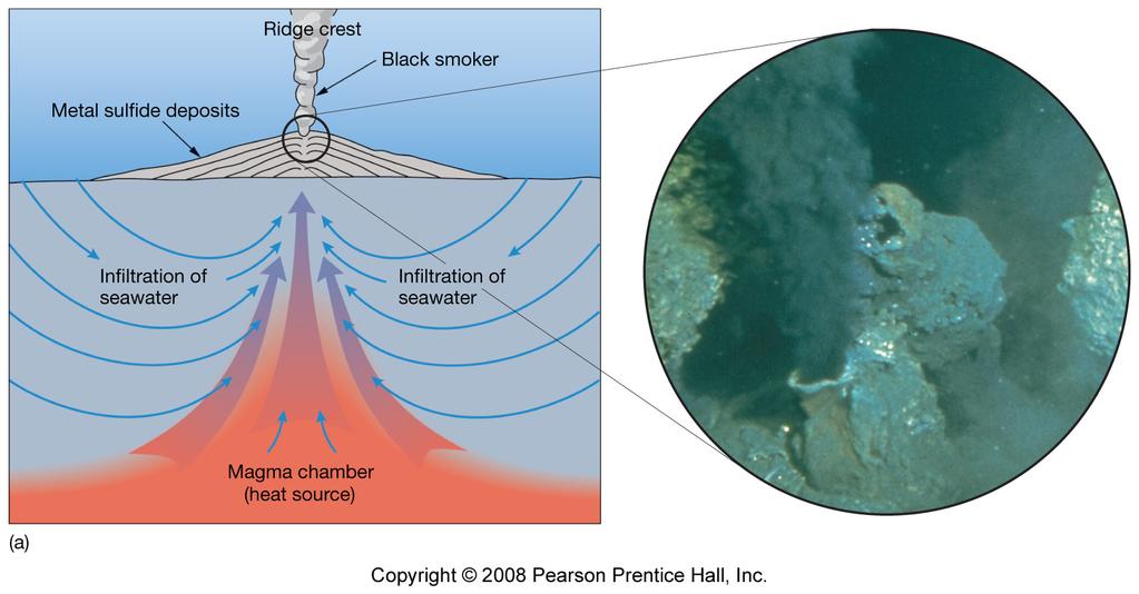
24 Ocean trenches Fig. 3.12
25 Volcanic arcs Landward side of ocean trench Island arc Chain of islands, e.g., Japan Continental arc Volcanic mountain range, e.g., Andes M ountains
26 Mid-ocean ridge Longest mountain chain On average, 2.5 km (1.5 miles) above surrounding sea floor Wholly volcanic Basaltic lava Divergent plate boundary
27 Mid-ocean ridge features Central rift valley, faults, and fissures Seamounts Pillow basalts Hydrothermal vents Deposits of metal sulfides Unusual life forms Fracture zones and transform faults
28 Rift valley, faults, and fissures Downdropped rift valley at central crest Cracks (fissures) and faults common Fig. 3.17

29 Mid-ocean ridge features Oceanic ridge Prominent rift valley Steep, rugged slopes Example: Mid-Atlantic Ridge Oceanic rise Gentler, less rugged slopes Example: East Pacific Rise
30 Volcanic features of mid-ocean rid ge Pillow lava or pillow basalts Hot lava chilled by cold seawater Smooth, rounded lobes of rock
31 Volcanic features of mid-ocean rid ge Hydrothermal vents Heated subsurface seawater migrates th rough cracks in ocean crust Warm-water vents <30 o C or 86 o F White smokers >30 o C <350 o C or 662 o F Black smokers > 350 o C

32 Hydrothermal vents Fig. 3.16a
33 Hydrothermal vents Dissolved metals precipitate to form metal sulfide deposits Unusual biological communities Able to survive without sunlight Archaeons and bacteria oxidize hydroge n sulfide gas to provide food
34 Fracture zones and transform faults Long linear zones of weakness offset axes of mid-ocean ridge Transform faults: movement in oppo site directions Fracture zones: extensions of fractur e zones (aseismic)
35 Fracture zones and transform faults Fig. 3.17

36 End of CHAPTER 3 Marine Provinces Fig. 3C
Bathymetry Measures the vertical distance from the ocean surface to mountains, valleys, plains, and other sea floor features
 1 2 3 4 5 6 7 8 9 10 11 CHAPTER 3 Marine Provinces Chapter Overview The study of bathymetry determines ocean depths and ocean floor topography. Echo sounding and satellites are efficient bathymetric tools.
Chapter Overview. Bathymetry. Measuring Bathymetry. Measuring Bathymetry
 CHAPTER 3 Marine Provinces Chapter Overview The study of bathymetry determines ocean depths and ocean floor topography. Echo sounding and satellites are efficient bathymetric tools. Most ocean floor features
Map shows 3 main features of ocean floor
 Map shows 3 main features of ocean floor 2017 Pearson Education, Inc. Chapter 3 Marine Provinces 2017 Pearson Education, Inc. 1 Chapter 3 Overview The study of bathymetry determines ocean depths and ocean
Ocean Basins, Bathymetry and Sea Levels
 Ocean Basins, Bathymetry and Sea Levels Chapter 4 Please read chapter 5: sediments for next class and start chapter 6 on seawater for Thursday Basic concepts in Chapter 4 Bathymetry the measurement of
The Ocean Floor Earth Science, 13e Chapter 13
 The Ocean Floor Earth Science, 13e Chapter 13 Stanley C. Hatfield Southwestern Illinois College The vast world ocean Earth is often referred to as the blue planet Seventy-one percent of Earth s surface
Oceanography, An Invitation to Marine Science 9e Tom Garrison. Ocean Basins Cengage Learning. All Rights Reserved.
 Oceanography, An Invitation to Marine Science 9e Tom Garrison 4 Ocean Basins Key Concepts Tectonic forces shape the seabed The ocean floor is divided into continental margins and deep ocean basins The
Earth s Continents and Seafloors. GEOL100 Physical Geology Ray Rector - Instructor
 Earth s Continents and Seafloors GEOL100 Physical Geology Ray Rector - Instructor OCEAN BASINS and CONTINENTAL PLATFORMS Key Concepts I. Earth s rocky surface covered by of two types of crust Dense, thin,
Foundations of Earth Science, 6e Lutgens, Tarbuck, & Tasa
 Foundations of Earth Science, 6e Lutgens, Tarbuck, & Tasa Oceans: The Last Frontier Foundations, 6e - Chapter 9 Stan Hatfield Southwestern Illinois College The vast world ocean Earth is often referred
Marine Science and Oceanography
 Marine Science and Oceanography Marine geology- study of the ocean floor Physical oceanography- study of waves, currents, and tides Marine biology study of nature and distribution of marine organisms Chemical
Unit 6: The Sea Floor
 Unit 6: The Sea Floor Turn to Page 62 in Introduction to the World s Oceans Study the bathymetric chart What features do you see? How do the Atlantic and Pacific Oceans differ? What do you think accounts
Lecture Outlines PowerPoint. Chapter 13 Earth Science 11e Tarbuck/Lutgens
 Lecture Outlines PowerPoint Chapter 13 Earth Science 11e Tarbuck/Lutgens 2006 Pearson Prentice Hall This work is protected by United States copyright laws and is provided solely for the use of instructors
The Ocean Floor Chapter 14. Essentials of Geology, 8e. Stan Hatfield and Ken Pinzke Southwestern Illinois College
 The Ocean Floor Chapter 14 Essentials of Geology, 8e Stan Hatfield and Ken Pinzke Southwestern Illinois College The vast world ocean Earth is often referred to as the water planet 71% of Earth s surface
ARE YOU READY TO THINK? Look at the first slide THINK PAIR SHARE!
 ARE YOU READY TO THINK? Look at the first slide THINK PAIR SHARE! WHAT PROMINENT FEATURE CAN YOU IDENTIFY IN THIS PICTURE? What do you think the different colors represent? Who might find such a picture
Origin and Evolution of the Ocean Floor
 Origin and Evolution of the Ocean Floor Outline Mapping the Ocean Floor Continental Margins Origin of Oceanic Lithosphere Structure of Ocean Crust Mapping the ocean floor Depth originally measured by lowering
MARINE GEOLOGY & GEOGRAPHY
 MARINE GEOLOGY & GEOGRAPHY Bathymetry BATHYMETRY BATHYMETRY THE UNDERWATER EQUIVALENT TO TOPOGRAPHY THE STUDY OF WATER DEPTH A BATHYMETRIC MAP SHOWS FLOOR RELIEF OR TERRAIN AS CONTOUR LINES Bathymetry
MARINE GEOLOGY & GEOGRAPHY
 MARINE GEOLOGY MARINE GEOLOGY & GEOGRAPHY Marine Geology 4 LAYERS OF THE EARTH CRUST THICKNESS: VARIES BETWEEN OCEAN & CONTINENTS 5-40 KM STATE: SOLID ELEMENTS: SILICON, ALUMINUM, CALCIUM, SODIUM, POTASSIUM
MULTIPLE CHOICE. Choose the one alternative that best completes the statement or answers the question.
 Geology 300, Physical Geology Spring 2019 Quiz Chapter 18, Seafloor Name MULTIPLE CHOICE. Choose the one alternative that best completes the statement or answers the question. 1) Abyssal fans are made
14.2 Ocean Floor Features Mapping the Ocean Floor
 14.2 Ocean Floor Features Mapping the Ocean Floor The ocean floor regions are the continental margins, the ocean basin floor, and the mid-ocean ridge. 14.2 Ocean Floor Features Continental Margins A continental
Shape of the seafloor. Shape of the seafloor. Shape of the seafloor. Shape of the seafloor. Shape of the seafloor. Shape of the seafloor
 Multibeam echo sounders - Research vessel Scripps Institution of Oceanography R/V Roger Revelle depth Source: Scripps Institution of Oceanography http://woodshole.er.usgs.gov/project-pages/caribbean/movie1.html
Earth / Environmental Science. Ch. 14 THE OCEAN FLOOR
 Earth / Environmental Science Ch. 14 THE OCEAN FLOOR The Blue Planet Nearly 70% of the Earth s surface is covered by the global ocean It was not until the 1800s that the ocean became an important focus
24. Ocean Basins p
 24. Ocean Basins p. 350-372 Background The majority of the planet is covered by ocean- about %. So the majority of the Earth s crust is. This crust is hidden from view beneath the water so it is not as
Chapter 9 Lecture Outline. Oceans: The Last Frontier
 Chapter 9 Lecture Outline Oceans: The Last Frontier The Vast World Ocean Earth is referred to as the blue planet 71% of Earth s surface is oceans and marginal seas Continents and islands comprise the remaining
Divergent Boundaries: Origin and Evolution of the Ocean Floor Earth - Chapter 13 Stan Hatfield Southwestern Illinois College
 Divergent Boundaries: Origin and Evolution of the Ocean Floor Earth - Chapter 13 Stan Hatfield Southwestern Illinois College Mapping the Ocean Floor Depth was originally measured by lowering weighted lines
Seafloor Morphology. Techniques of Investigation. Bathymetry and Sediment Studies
 Seafloor Morphology I f we select a grid for the surface of the earth (i.e. 5 km 2 ) and assign it an average elevation in relation to sea level, we can construct a graph of elevation versus area of the
Oceanography is the scientific study of oceans Oceans make up over 70% of the Earth s surface
 Oceanography Oceanography is the scientific study of oceans Oceans make up over 70% of the Earth s surface An ocean must be large and have features which set it apart from other oceans (currents, water
Divergent Boundaries: Origin and Evolution of the Ocean Floor
 1 2 3 4 5 6 7 8 9 10 11 12 Divergent Boundaries: Origin and Evolution of the Ocean Floor Earth, 12 th Edition, Chapter 13 Chapter 13 Divergent Boundaries From 1872 to 1876, the HMS Challenger expedition
The Sea Floor. Chapter 2
 The Sea Floor Chapter 2 Geography of the Ocean Basins World ocean is the predominant feature on the Earth in total area Northern Hemisphere = 61% of the total area is ocean. Southern Hemisphere = about
Ocean Floor. Continental Margins. Divided into 3 major regions. Continental Margins. Ocean Basins. Mid-Ocean Ridges. Include:
 Ocean Floor Divided into 3 major regions Continental Margins Ocean Basins Mid-Ocean Ridges Continental Margins Include: Continental Shelves Continental Slopes Continental Rise 1 Continental Shelves Part
Earth s Seafloors. Ocean Basins and Continental Margins. Introductory Oceanography Ray Rector - Instructor
 Earth s Seafloors Ocean Basins and Continental Margins Introductory Oceanography Ray Rector - Instructor OCEAN BASINS and CONTINENTAL PLATFORMS Key Concepts I. Earth s rocky surface covered by of two types
The Marine Environment
 The Marine Environment SECTION 16.1 Shoreline Features In your textbook, read about erosional landforms, beaches, estuaries, longshore currents, and rip currents. For each statement below, write or. 1.
Origin and Evolution of the Ocean Floor
 Chapter 13 Lecture Earth: An Introduction to Physical Geology Twelfth Edition Origin and Evolution of the Ocean Floor Tarbuck and Lutgens Chapter 13 Divergent Boundaries An Emerging Picture of the Ocean
Objectives: Describe the structure of the ocean floor. Describe light intensity and temperature characteristics at different ocean depths.
 Ocean Structure Virtual Lab What are some characteristics of the ocean and the ocean floor? Earths highest mountains, deepest valleys, and flattest plains are found not on land but under the ocean. Beyond
Small area of the ocean that is partially surrounded by land. The Ocean Basins. Three Major Oceans. Three Major Oceans. What is a SEA?
 The Ocean Basins How Deep is the Ocean? 1 2 Three Major Oceans Three Major Oceans Pacific Atlantic the shallowest ocean (3.3km average depth) Indian second shallowest ocean (3.8km average depth) Pacific
I. Earth s Layers a. Crust: Earth s outside layer. Made of mostly rock. i. Continental: er; made of mostly granite, forms the continents and shallow
 I. Earth s Layers a. Crust: Earth s outside layer. Made of mostly rock. i. Continental: er; made of mostly granite, forms the continents and shallow sea beds, floats! ii. Oceanic: er; dense rock such as
Lecture 05: Ocean Basins. Hypsometric Curve. Consider Ocean Basins: What is the elevation of Chambana?
 Lecture 05: Ocean Basins 1 Hypsometric Curve What is the elevation of Chambana? Shows distribution of surface relative to sea level ~67% below sea level Mean ocean depth ~ -3.7 km (well below sea level)
Seas. A sea is a part of an ocean that is nearly surrounded by water. The Mediterranean, Arctic and Black Sea are really part of the Atlantic Ocean.
 Exploring the Ocean Since ancient times people have studied the ocean such as waters and ocean floor It provides food and services, and serves as a route for trade and travel The World s Oceans 71% of
Chapter 2 Plate Tectonics and the Ocean Floor
 Chapter 2 Plate Tectonics and the Ocean Floor Matching. Match the term or person with the appropriate phrase. You may use each answer once, more than once or not at all. 1. hydrothermal vents A. convergent
Plate Tectonics: A Unifying Theory
 Plate Tectonics: A Unifying Theory What is Plate Tectonics? - 7 large tectonic plates and many smaller ones that break up the lithosphere - Plates are brittle and float on asthenosphere and glide past
OCN 201 Physiography of the Seafloor
 OCN 201 Physiography of the Seafloor Hypsometric Curve for Earth s solid surface Note histogram Hypsometric curve of Earth shows two modes. Hypsometric curve of Venus shows only one! Why? Ocean Depth vs.
OCN 201 Physiography of the Seafloor
 OCN 201 Physiography of the Seafloor 1 Ocean Depth versus Continental Height Why do we have dry land? Solid surface of Earth is dominated by two levels: Land with a mean elevation of +840 m (29% of Earth
Full file at
 Essentials of Oceanography, 10e (Trujillo/Keller) Chapter 2 Plate Tectonics and the Ocean Floor Match the term with the appropriate phrase. You may use each answer once, more than once or not at all. A)
Essential Question: How are the geological features that exist on land similar to the geological features on the ocean floor?
 Essential Question: How are the geological features that exist on land similar to the geological features on the ocean floor? Geography of the Oceans The world ocean can be divided into four main ocean
CHAPTER 3 Ocean Basins
 Review: What Drives Plate Motions: (1) Density vs. Gravity: causes oceanic crust to sink in subduction zones, causes crust to extend at spreading ridges (called ridge push, but the ridge is not pushing,
Oceanography. Oceanography is the study of the deep sea and shallow coastal oceans.
 Oceanography Oceanography is the study of the deep sea and shallow coastal oceans. Studying the Ocean Floor To determine the shape and composition of the ocean floor, scientists use techniques such as
Isostasy, Bathymetry and the Physiography of the Ocean Floor
 Isostasy, Bathymetry and the Physiography of the Ocean Floor EPSS 15 Spring 2017 Ad art for NBC Radio, 1939 Archimedes (c. 287 BCE 212 BCE) Greek mathematician, physicist and engineer Archimedes Principle:
Almost of Earth is covered by water. On a map, the continents appear as huge islands surrounded by a vast global ocean.
 Earth s Oceans & Ocean Floor Date: Feelin Blue What are Earth s five main oceans? Almost of Earth is covered by water. On a map, the continents appear as huge islands surrounded by a vast global ocean.
Unit 4 - Water. Earth s Interior. Earth s Interior. Continental Drift. Continental Drift. Continental Drift. Crust. Mantle. Core.
 Unit 4 - Water How did the oceans form? What special adaptations do saltwater organisms have? Where does our water come from? How do humans affect the Earth s water? Crust Rigid outer shell of Earth Oceanic
OCEANOGRAPHY MEASURING THE DEPTHS OF THE OCEANS
 Water 2 page 1 OCEANOGRAPHY Name If all the water was drained from the ocean basins, what kind of surface would be revealed? It would not be the quiet, subdued topography as was once thought, but a surface
Chapter 02 The Sea Floor
 Chapter 02 The Sea Floor Multiple Choice Questions 1. One of the following is not one of the world's major ocean basins: A. Atlantic Ocean B. Arctic Ocean C. Indian Ocean D. Antarctic Ocean E. Pacific
The Marine Environment
 The Marine Environment SECTION 16.1 Shoreline Features In your textbook, read about erosional landforms, beaches, estuaries, longshore currents, and rip currents. For each statement below, write true or
Geologic Evolution of Latin America. Plate Tectonics: General Concepts & Applications to Latin America
 Geologic Evolution of Latin America Plate Tectonics: General Concepts & Applications to Latin America Structure of Earth: 3 major divisions of Core, Mantle, and Crust Upper mantle differs in the way that
GENERAL GEOLOGY Fall Chapter 18: The Sea Floor. Partial Examination IV Study Guide Dr. Glen S. Mattioli
 GENERAL GEOLOGY 1113-005 Fall 2008 Partial Examination IV Study Guide Dr. Glen S. Mattioli Note that these are NOT questions, but rather are a list of topics that we have covered either in class or are
The Major Ocean Basins and Their Features
 Where Submarines Lurk Recent satellite studies and deep-sea mapping programs have revealed in dramatic fashion that the ocean floor is not flat. Indeed, the terrain of the ocean floor surpasses that of
Geography of the world s oceans and major current systems. Lecture 2
 Geography of the world s oceans and major current systems Lecture 2 WHY is the GEOMORPHOLOGY OF THE OCEAN FLOOR important? (in the context of Oceanography) WHY is the GEOMORPHOLOGY OF THE OCEAN FLOOR important?
Plate Tectonics. entirely rock both and rock
 Plate Tectonics I. Tectonics A. Tectonic Forces are forces generated from within Earth causing rock to become. B. 1. The study of the origin and arrangement of Earth surface including mountain belts, continents,
Earth Science Lesson Plan Quarter 2, Week 10, Day 1
 Earth Science Lesson Plan Quarter 2, Week 10, Day 1 Outcomes for Today Standard Focus: PREPARE 1. Background knowledge necessary for today s reading. Beaches are created by the actions of waves, tides,
1. Name at least one place that the mid-atlantic Ridge is exposed above sea level.
 Interpreting Tectonic and Bathymetric Maps. The purpose of this lab is to provide experience interpreting the bathymetry of the seafloor in terms of tectonic and geologic settings and processes. Use the
Earth and Space Science Semester 2 Exam Review. Part 1. - Convection currents circulate in the Asthenosphere located in the Upper Mantle.
 Earth and Space Science 2015 Semester 2 Exam Review Part 1 Convection -A form of heat transfer. - Convection currents circulate in the Asthenosphere located in the Upper Mantle. - Source of heat is from
Earthquakes. Earthquakes are caused by a sudden release of energy
 Earthquakes Earthquakes are caused by a sudden release of energy The amount of energy released determines the magnitude of the earthquake Seismic waves carry the energy away from its origin Fig. 18.1 Origin
Marine Geosciences / Oceanography Fields and disciplines
 Marine Geosciences / Oceanography Fields and disciplines Marine Geosciences; Oceanography Chemical Oceanography Marine chemistry; marine geochemistry Biological Oceanography Marine biology; marine biogeochemistry
60% water. Big Bang: 14,000 millions years ago The Earth originated about 4,500 millions years ago its orbit allows water to exist in a liquid state!
 Ch2. The Sea Floor #1 Why geology of the oceans? Marine habitats are directly shaped by geological processes The form of the coastlines The depth of the water Type of bottom (muddy, sandy, rocky) #2 Geological
Sea-Floor Spreading, Subduction,& Plate Boundaries. Lecture Continental Fit 2. Similar Rocks, Ages 3. Similar Fossils 4. Widespread Glaciation
 Sea-Floor Spreading, Subduction,& Plate Boundaries Lecture 21 Prop: Test 3 Invitations Alfred Wegener s Evidence for Continental Drift 1. Continental Fit 2. Similar Rocks, Ages 3. Similar Fossils 4. Widespread
In 1990, 50% of the U.S. population lived within 75 km of a coast. By 2010, 75% of the U.S. population will live within 75 km of a coast.
 In 1990, 50% of the U.S. population lived within 75 km of a coast. By 2010, 75% of the U.S. population will live within 75 km of a coast. High Tech Methods for Surveying the Deep Sea Floor Fig. 20.18 1
6th Grade Science Sample Assessment Items S6E3c.
 Composition 6th Grade Science Sample Assessment Items Ocean water differs from freshwater in that it has. A. a lower temperature B. a higher temperature C. a higher concentration of silicon dioxide D.
PHYSICAL GEOLOGY AND THE ENVIRONMENT (2 ND CANADIAN EDITION)
") Chapter 2: Plate Tectonics Chapter Summary: Plate tectonics is a theory that suggests Earth's surface is divided into several large plates that change position and size. Intense geologic activity occurs
Chapter 2: Plate Tectonics Chapter Summary: Plate tectonics is a theory that suggests Earth's surface is divided into several large plates that change position and size. Intense geologic activity occurs
Plate Tectonics. 1)The plate tectonic system 2)A theory is born 3) Early evidence for continental drift 4) Continental drift and paleomagnetism
The plate tectonic system 2)A theory is born 3) Early evidence for continental drift 4) Continental drift and paleomagnetism") Plate Tectonics Plate boundaries 1)The plate tectonic system 2)A theory is born 3) Early evidence for continental drift 4) Continental drift and paleomagnetism 6)History and future of plate motions system
Plate Tectonics Plate boundaries 1)The plate tectonic system 2)A theory is born 3) Early evidence for continental drift 4) Continental drift and paleomagnetism 6)History and future of plate motions system
UNIT 3 GEOLOGY VOCABULARY FLASHCARDS THESE KEY VOCABULARY WORDS AND PHRASES APPEAR ON THE UNIT 3 CBA
 UNIT 3 GEOLOGY VOCABULARY FLASHCARDS THESE KEY VOCABULARY WORDS AND PHRASES APPEAR ON THE UNIT 3 CBA A map that shows Earth s Topographic Map surface topography, which is Earth s shape and features Contour
Chapter Two. Figure 02_02. Geography of the Ocean Basins. The Sea Floor
 Chapter Two The Sea Floor Geography of the Ocean Basins Figure 02_02 The world ocean is the predominant feature on the Earth in total area. In the Northern Hemisphere, 61% of the total area is ocean. In
Test on Chapters 7-11 Monday, April 28, 2014 No Calculator Required
 Test on Chapters 7-11 Monday, April 28, 2014 No Calculator Required Chapter Sections: Oceans: 7.1 7.2 7.4 Bathymetry: 8.3 Earth s Interior: 10.1 10.2 10.3 Plate Tectonics: 11.1 11.2 11.3 Study/Review:
Crustal Boundaries. As they move across the asthenosphere and form plate boundaries they interact in various ways. Convergent Transform Divergent
 Name: Date: Period: Plate Tectonics The Physical Setting: Earth Science CLASS NOTES Tectonic plates are constantly moving and interacting As they move across the asthenosphere and form plate boundaries
E-PG PATHSHALA IN EARTH SCIENCE OCEANOGRAPHY OCEAN MORPHOLOGY AND RELIEF. By Prof. A. Balasubramanian. Objectives
 E-PG PATHSHALA IN EARTH SCIENCE OCEANOGRAPHY OCEAN MORPHOLOGY AND RELIEF By Prof. A. Balasubramanian Objectives After attending this lesson, the user would be able to understand the profile of the continents
Plate Tectonics: The New Paradigm
 Earth s major plates Plate Tectonics: The New Paradigm Associated with Earth's strong, rigid outer layer: Known as the lithosphere Consists of uppermost mantle and overlying crust Overlies a weaker region
Directed Reading. Section: The Water Planet. surface is called the a. Earth s ocean. b. Pacific Ocean. c. salt-water ocean. d. global ocean.
 Skills Worksheet Directed Reading Section: The Water Planet 1. The body of salt water covering nearly three-quarters of the Earth s surface is called the a. Earth s ocean. b. Pacific Ocean. c. salt-water
TAKE HOME EXAM 8R - Geology
 Name Period Date TAKE HOME EXAM 8R - Geology PART 1 - Multiple Choice 1. A volcanic cone made up of alternating layers of lava and rock particles is a cone. a. cinder b. lava c. shield d. composite 2.
EPSS 15 Introduction to Oceanography Spring Physiography of the Ocean Basins
 EPSS 15 Introduction to Oceanography Spring 2017 Physiography of the Ocean Basins ISOSTASY The surface of the earth can be subdivided into two major areas: 1) the ocean basins and 2) the continents. Although
ANOTHER MEXICAN EARTHQUAKE! Magnitude 7.1, Tuesday Sept. 19, 2017
 ANOTHER MEXICAN EARTHQUAKE! Magnitude 7.1, Tuesday Sept. 19, 2017 Why is there no oceanic crust older than 200 million years? SUBDUCTION If new oceanic crust is being continuously created along the earth
1.4 Notes: Plates Converge or Scrape Past Each Other Think About Tectonic Plates Push Together at Convergent Boundaries
 1.4 Notes: Plates Converge or Scrape Past Each Other Think About If new crust is created at divergent boundaries, why does the total amount of crust on Earth stay the same? Tectonic Plates Push Together
2. Explain why there are these two predominate elevations. (Hint: think about isostasy and the type of materials we used to demonstrate buoyancy).
.") IDS 102 Plate Tectonics Questions Part I: Observations- Four maps of world are positioned around the room. Answer the questions associated with each map and record your general observations about the maps.
IDS 102 Plate Tectonics Questions Part I: Observations- Four maps of world are positioned around the room. Answer the questions associated with each map and record your general observations about the maps.
Marine Sediments. Introductory Oceanography. Ray Rector: Instructor
 Marine Sediments Introductory Oceanography Ray Rector: Instructor Ocean Basins are Vast Sinks for Huge Amounts of Sediment from Numerous Different Sources Four Major Types of Seafloor Sediments 1. Lithogenous
USU 1360 TECTONICS / PROCESSES
 USU 1360 TECTONICS / PROCESSES Observe the world map and each enlargement Pacific Northwest Tibet South America Japan 03.00.a1 South Atlantic Arabian Peninsula Observe features near the Pacific Northwest
Plate Tectonics CHAPTER 17
 Plate Tectonics CHAPTER 17 Layers of the Earth A. Crust- solid, 5-70 km thick Moho Two Types of Crust: Oceanic- ocean floor, more dense then because of more iron Continental-dry land (mostly silicates
Lecture 26: Marine Geology Read: Chapter 21 Homework due December 3
 Learning Objectives (LO) Lecture 26: Marine Geology Read: Chapter 21 Homework due December 3 What we ll learn today:! 1. Describe the world s five oceans! 2. Understand patterns of ocean circulation! 3.
Introduction To Plate Tectonics Evolution. (Continents, Ocean Basins, Mountains and Continental Margins)
") Introduction To Plate Tectonics Evolution (Continents, Ocean Basins, Mountains and Continental Margins) Geo 386 (Arabian Shield Course) Dr. Bassam A. A. Abuamarah Mohanna G E O 3 8 6 A R A B I A N G E
Introduction To Plate Tectonics Evolution (Continents, Ocean Basins, Mountains and Continental Margins) Geo 386 (Arabian Shield Course) Dr. Bassam A. A. Abuamarah Mohanna G E O 3 8 6 A R A B I A N G E
Sir Francis Bacon, 1620, noted that the continental coasts on opposites sides of the Atlantic fit together like puzzle pieces.
 Plate Tectonics Sir Francis Bacon, 1620, noted that the continental coasts on opposites sides of the Atlantic fit together like puzzle pieces. Could North and South America once have been joined to Europe
Earth s Structure and Surface
 Earth s Structure and Surface Structure of the Earth The earth is thought have originated about 4.5 billion years ago from a cloud or clouds of dust. The dust was the remains of a huge cosmic explosion
1. Define habitat and describe how geologic processes influence habitats. Habitats 2. How much of the earth s surface is covered by sea water?
 1. Define habitat and describe how geologic processes influence habitats. Habitats are the natural environments in which organisms live. They are directly shaped by geological processes, which influence
Introduction to Oceanography. Chapter 2: Plate Tectonics Overview
 Introduction to Oceanography Chapter 2: Plate Tectonics Overview Much evidence supports plate tectonics theory. The plate tectonics model describes features and processes on Earth. Plate tectonic science
Convergent plate boundaries. Objective to be able to explain the formation and key features of these zones.
 Convergent plate boundaries Objective to be able to explain the formation and key features of these zones. Destructive plate margins When plates collide due to convection currents/slab pull in the asthenosphere
Plate Boundaries & Resulting Landforms
 Plate Boundaries & Resulting Landforms Divergent Plate Boundaries (plates being pulled apart) Type: oceanic plates Description: rising magma gently lifts the crust creating a ridge. The flow of convection
Plate Tectonics. Structure of the Earth
 Plate Tectonics Structure of the Earth The Earth can be considered as being made up of a series of concentric spheres, each made up of materials that differ in terms of composition and mechanical properties.
Essentials of Oceanography Eleventh Edition
 Chapter Chapter 1 2 Clickers Lecture Essentials of Oceanography Eleventh Edition Plate Tectonics and the Ocean Floor Alan P. Trujillo Harold V. Thurman Chapter Overview Much evidence supports plate tectonics
Sea-Floor Spreading, Subduction,& Plate Boundaries. Lecture 23. Geol 101 (Kite) Quiz 9, April Geol 101 (Kite) Quiz 9, April 2006
 Quiz 9, April Geol 101 (Kite) Quiz 9, April 2006") Sea-Floor Spreading, Subduction,& Plate Boundaries Lecture 23 Prop: Test 3 Invitations Geol 101 (Kite) Quiz 9, April 2005 ******************************* * You are cordially invited * Name * to attend
Sea-Floor Spreading, Subduction,& Plate Boundaries Lecture 23 Prop: Test 3 Invitations Geol 101 (Kite) Quiz 9, April 2005 ******************************* * You are cordially invited * Name * to attend
Alfred Wegener gave us Continental Drift. Fifty years later...
 CHAPTER 2 Plate Tectonics and the Ocean Floor Plate Tectonics: summary in haiku form Alfred Wegener gave us Continental Drift. Fifty years later... Words Chapter Overview Much evidence supports plate tectonics
Chapter 2. The Planet Oceanus
 Chapter 2 The Planet Oceanus Composition of the Earth The Earth consists of a series of concentric layers or spheres which differ in chemistry and physical properties. There are two different ways to describe
Movement of the Earth s Crust: Formation of: Mountain s Plateau's and Dome s
 Movement of the Earth s Crust: Formation of: Mountain s Plateau's and Dome s References Information taken from several places including Prentice Hall Earth Science: @ http://www.eram.k12.ny.us/education/components/docmgr/default.php?sectiondetaili
A) B) C) D) 4. Which diagram below best represents the pattern of magnetic orientation in the seafloor on the west (left) side of the ocean ridge?
 B) C) D) 4. Which diagram below best represents the pattern of magnetic orientation in the seafloor on the west (left) side of the ocean ridge?") 1. Crustal formation, which may cause the widening of an ocean, is most likely occurring at the boundary between the A) African Plate and the Eurasian Plate B) Pacific Plate and the Philippine Plate C)
1. Crustal formation, which may cause the widening of an ocean, is most likely occurring at the boundary between the A) African Plate and the Eurasian Plate B) Pacific Plate and the Philippine Plate C)
FORCES ON EARTH. An investigation into how Newton s Laws of Motion are applied to the tectonic activity on Earth.
 FORCES ON EARTH An investigation into how Newton s Laws of Motion are applied to the tectonic activity on Earth. GEOLOGY Geologists scientists who study the forces that make and shape the Earth Geologists
Chapter 2 Plate Tectonics and the Ocean Floor
 Chapter 2 Plate Tectonics and the Ocean Floor Chapter Overview Much evidence supports plate tectonics theory. The plate tectonics model describes features and processes on Earth. Plate tectonic science
CHAPTER 2 THE WAY THE EARTH WORKS: EXAMINING PLATE TECTONICS
 CHAPTER 2 THE WAY THE EARTH WORKS: EXAMINING PLATE TECTONICS Coverage of plate tectonics is required early in introductory Geology as context for the mineralogy, petrology, structure, internal processes,
Plate Tectonics: A Scientific Revolution Unfolds
 Chapter 2 Lecture Earth: An Introduction to Physical Geology Eleventh Edition Plate Tectonics: A Scientific Revolution Unfolds Tarbuck and Lutgens From Continental Drift to Plate Tectonics Prior to the