The Continental Shelf Project: An overview of research activities in the Arctic Ocean on behalf of the Kingdom of Denmark
|
|
|
- Imogen Snow
- 5 years ago
- Views:
Transcription

1 The Continental Shelf Project: An overview of research activities in the Arctic Ocean on behalf of the Kingdom of Denmark Geological Survey of Denmark and Greenland Ministry of Climate and Energy John R. Hopper Christian Marcussen & many A76 Researchers 1


2 Photo: Bjørn Eriksson Russisk flag under Nordpolen

3 Hydrocarbon Resources Barents Sea Greenland Probability for one field with more than 50 MMBOE Russian FederaMon Canada USA Source: US Geological Survey
4 Most resources are within 200 M 4
5 What is UNCLOS? UNCLOS: United Nations Convention on the Law of the Sea main part negotiated from , came into force in 1994 defines rights and responsibilities for how nations may use the world s oceans Replaces 1958 Geneva Conventions on the Law of Sea Ratified by 161 states, inc. all Arctic nations except for the US Ratified by the Kingdom of Denmark on November 16,2004 5
6 What is Article 76 of UNCLOS? Defines the Continental Shelf of a coastal state Article 76 provides the mechanisms by which a coastal state may claim rights to the seabed and subsoil of submarine areas. Includes natural resources of the seabed and subsoil defined as mineral and non-living resources living organisms belonging to sedentary species 6
7 Article 76 of UNCLOS A key aspect is that it defines how a coastal state may claim rights beyond the 200 nautical mile (M) EEZ. Claims must be submitted, with documentation, within 10 years after a state ratifies the convention Kingdom of Denmark deadline: November 16,
8 8

9 Foot of Slope (FOS): maximum change of gradient at the base of the continental slope 1 nautical mile = mile = 1852 meters Formula lines Either FOS + 60 nautical miles or 1% sediment formula Constraint lines Either 350 nautical miles or 2500 meter isobath nautical miles 9
10 Note that the key to an extended shelf claim is first and foremost Morphological Geology can be used to support a claim, but is not part of the legal definition. 10
11 Key Documentation Required The 2500 meter isobath - must be mapped convincingly The Foot of Slope both require multibeam and single beam mapping Sediment thickness and continuity seismic reflection and refraction data 11

12 Bathymetric Data 12 Background: IBCAO, M. Jacobsson, Stockholm University
13 Kingdom of Denmark - Areas of interest 2 areas: the Faroe Islands 3 areas: Greenland Submission for the area N of the Faroe Islands: April 2009 Submission for the area S of the Faroe Islands: late 2010 Ongoing work in the areas around Greenland with a deadline in

14 Greenland Extended Shelf: Southwest coastal area: Data collecmon to document a claim completed, analyses in progress NE Greenland: Some data collecmon completed - final data required planned in 2011 North of Greenland: Significant progress, but much more required. Planned in 2011, 2012?? 14

15 Focus on the Arctic Ocean north of Greenland 15

16 North of Greenland UNCLOS Documentation Field work from 2006 to 2009 Focus on the acquisition of bathymetric and seismic data. The white ellipses show the LOMROG III work areas planned for 2012 or White stippled lines unofficial median lines. 16


17 Acquisition of multi-beam bathymetric data in polar sea-ice Pirouette multi-beam 3D - Morris Jesup Rise Photo and 3D map: Martin Jakobsson, Stockholm University 17


18 Photo: MarMn Jakobsson Photo: MarMn Jakobsson Photo: Thomas Funck Photo: Thomas Funck Acquisition of bathymetric and seismic data 2007 and 2009 Russian nuclear icebreaker required in areas with extreme ice conditions.

, not in meters Basement")
19 Seismic Reflection Data Seabed Sediments Example of processed seismic reflection data from LOMROG II: Provides a measure of sediment thickness - but this is in traveltime (seconds), not in meters Basement 19

20 Seismic Reflection Data 20


21 Seismic Refraction Data Used to determine velocity: convert time to depth from T. Funck 21


22 International cooperation Canadian and Danish geophysicists Photo: Martin Jakobsson Russian and Swedish icebreakers working for the Danish project Photo: Jon Biggar Canadian and US icebreakers Photo: Janice Lang, NRCan/DRDC Canadian and Danish hydrographers
23 Cooperation with other countries All activities of the Continental Shelf Project in the Arctic Ocean on behalf of the Kingdom of Denmark have been in cooperation with other countries: LORITA (2006), LOMBAG and LOMGRAV (2009) expeditions based on Canadian logistics LOMROG I (2007) cruise with Oden: 50/50 cooperation with the Swedish Polar Research Secretariat, Stockholm University and Canada LOMROG II (2009) cruise with Oden: cooperation with the Swedish Polar Research Secretariat and Canada with Russian participation Initiative to continue and strengthen Nordic Cooperation in Polar Science 23
24 International cooperation Logistical cooperation during data acquisition between all Arctic coastal states with the following benefits: Sharing of logistical resources Considerable cost savings Scientific cooperation: Better understanding of the geology of the Arctic Ocean => better supported submissions Consultations and discussions regarding scientific issues of specific features, i.e., the Lomonosov Ridge between Canada, Denmark and the Russian Federation with USA as an observer have taken place since
25 Continental Shelf Project Scientific Outcome Data policy: results published in international scientific journals data will be released (bathymetric data already released for regional compilations (IBCAO) Increased knowledge of an area with sparse data tectonic evolution, disputed plate boundaries paleoclimate history, Arctic is very sensitive to global climate change physical oceanography, water mass exchange between the Arctic and other oceans sensitive ecological systems 25
26 Continental Shelf Project Associated Research LORITA (2006): Søren Rysgaard (sampling of ice cores) LOMROG I (2007) cruise with Oden: Søren Rysgaard in cooperation with Roskilde Univeristy (sampling of ice cores), DTU-Space (ice thickness); Swedish projects (geology, oceanography, accumulation of mercury) LOMROG II (2009) cruise with Oden: Oceanography (DMI and Göteborg University), Søren Rysgaard in cooperation with University of Washington (sampling of ice cores), DTU-Space (ice thickness), DTU-CBS (Nicolai Blom DNA of the Polar Seas), DTU-Aqua (Lone Gram - bacteria); Swedish projects: geology, plankton ecology (Danish participant) 26

27 Ice Core Sampling LORITA (2006) Project organized by Søren Rysgaard 27

28 Ice Core Sampling - LOMROG I (2007) Søren Rysgaard in cooperation with Roskilde University 28
 Swedish research")
29 Piston Coring LOMROG I (2007) Swedish research projects 29
 Swedish research projects")
30 Water column sampling LOMROG I (2007) Swedish research projects 30

31 Oceanography LOMROG II (2009) DMI and Göteborg University 31

32 Ice Core Sampling LOMROG II (2009) Søren Rysgaard in cooperation with Univ. of Washington 32

33 Plankton tows LOMROG II (2009) Swedish Research Projects with Danish participants 33

34 Plankton ecology LOMROG II (2009) Swedish Research Projects with Danish participants 34

35 More flags at the North Pole Photo: Adam Jeppesen 35
36 Future activities In 2011 a 24 day cruise with Oden is planned in the area off NE Greenland acquisition of bathymetric, refraction, and reflection seismic data, geological sampling. Decision pending availability of Oden. Possibilities for Danish science projects will be announced through the Danish Centre for Marine Research. In 2012 a third LOMROG cruise is planned in the area north of Greenland. 36

37 Thank you for your attention! Foto: Ludvig Löwemark More information
Operating conditions in the Arctic: Data acquisition in the Arctic Ocean by the Continental Shelf Project of the Kingdom of Denmark
 Operating conditions in the Arctic: Data acquisition in the Arctic Ocean by the Continental Shelf Project of the Kingdom of Denmark By Christian Marcussen Geological Survey of Denmark and Greenland Danish
Bathymetric data acquisition in Arctic waters
 Bathymetric data acquisition in Arctic waters within the Danish Continental Shelf Project Morten Sølvsten, Uni Bull, Richard Pedersen & Christian Marcussen Arctic-Antarctic Seafloor Mapping Meeting 2011
Challenges of Collecting Data for Article 76 in Ice Covered Waters of the Arctic
 Challenges of Collecting Data for Article 76 in Ice Covered Waters of the Arctic 5 th ABLOS Conference Monaco October 16, 2008 Richard MacDougall - Canada Jacob Verhoef - Canada Wendell Sanford - Canada
OUTER CONTINENTAL SHELF CLAIMS IN THE ARCTIC. Presentation given by Dr. Kamrul Hossain ASA University Bangladesh 15 March 2010
 OUTER CONTINENTAL SHELF CLAIMS IN THE ARCTIC Presentation given by Dr. Kamrul Hossain ASA University Bangladesh 15 March 2010 Contents Historical background of the continental shelf Concept of continental
CONFERENCE OF PARLIAMENTARIANS OF THE ARCTIC REGION. UN LOS Convention and the extended continental shelf in the Arctic
 CONFERENCE OF PARLIAMENTARIANS OF THE ARCTIC REGION UN LOS Convention and the extended continental shelf in the Arctic Presentation given by Dr. Kamrul Hossain Finnish Parliament 18 November 2009 Contents
Seafloor Mapping in the High Arctic: The Challenges and the Joys
 Seafloor Mapping in the High Arctic: The Challenges and the Joys Larry Mayer Center for Coastal and Ocean Mapping / NOAA- UNH Joint Hydrographic Center University of New Hampshire, USA Martin Jakobsson
The Arctic Cold War The battle to control resources while the future of the earth hangs in the balance.
 The Arctic Cold War The battle to control resources while the future of the earth hangs in the balance. 1 The Arctic Cold War The battle to control resources while the future of the earth hangs in the
UNCLOS Article 76- Formulae and constraint lines
 UNCLOS Article 76- Formulae and constraint lines Dr Lindsay Parson (UNCLOS Group, National Oceanography Centre, UK) ABLOS TUTORIAL SESSION - Article 76 of UNCLOS 10th October 2005 IHO/IAG/IOC Advisory
COMPLICATIONS IN DELIMITING THE OUTER CONTINENTAL SHELF. Ron Macnab Geological Survey of Canada (Retired)
") COMPLICATIONS IN DELIMITING THE OUTER CONTINENTAL SHELF Ron Macnab Geological Survey of Canada (Retired) DISCLAIMER The contents of this presentation are the author s personal views only, and do not represent
COMPLICATIONS IN DELIMITING THE OUTER CONTINENTAL SHELF Ron Macnab Geological Survey of Canada (Retired) DISCLAIMER The contents of this presentation are the author s personal views only, and do not represent
CONTINENTAL SHELF SUBMISSION OF ANGOLA - EXECUTIVE SUMMARY -
 CONTINENTAL SHELF SUBMISSION OF ANGOLA - EXECUTIVE SUMMARY - INDEX List of Figures 2 List of Tables 3 1 Introduction 5 2 Provisions of Article 76 7 3 Angolan Institutions responsible for the Submission
EXECUTIVE SUMMARY A SUBMISSION OF DATA AND INFORMATION ON THE OUTER LIMITS OF THE CONTINENTAL SHELF OF THE REPUBLIC OF NIGERIA PURSUANT TO
 EXECUTIVE SUMMARY A SUBMISSION OF DATA AND INFORMATION ON THE OUTER LIMITS OF THE CONTINENTAL SHELF OF THE REPUBLIC OF NIGERIA PURSUANT TO PART VI OF AND ANNEX II TO THE UNITED NATIONS CONVENTION ON THE
Draft Presentation Carleton Conference on the Arctic Is There a Need for New Legal Regime in the Arctic?
 Draft Presentation Carleton Conference on the Arctic Is There a Need for New Legal Regime in the Arctic? Donald McRae, University of Ottawa The climatic changes affecting the Arctic have lead to visions
Marine Geospatial Software: Generating Economic Benefits from Hydrographic Data and Calculation of Maritime Boundaries
 Marine Geospatial Software: Generating Economic Benefits from Hydrographic Data and Calculation of Serge LEVESQUE and Alexis CARDENAS, Canada Key words: marine geospatial data, hydrography, economic benefits,
Article 76, variations in annotation and implementation seen in submission documents for the claim of Extended Continental Shelf
 Article 76, variations in annotation and implementation seen in submission documents for the claim of Extended Continental Shelf Mr. Shin Tani Chairman, IHO/IAG Advisory Board on the Law of the Sea (ABLOS)
MAPS AND COORDINATES...
 Table of Contents 1 INTRODUCTION... 2 2 MAPS AND COORDINATES... 3 3 ADVISORY ASSISTANCE FROM COMMISSION MEMBERS... 3 4 PROVISIONS OF ARTICLE 76 INVOKED... 3 5 OUTSTANDING MARITIME DELIMITATIONS... 4 6
High-resolution Geophysical Mapping of Submarine Glacial Landforms
 High-resolution Geophysical Mapping of Submarine Glacial Landforms M. Jakobsson 1, J.A. Dowdeswell 2, M. Canals 3, B.J. Todd 4, E.K. Dowdeswell 2, K.A. Hogan 5 L.A. Mayer 6 1 Stockholm University, Sweden
IRELAND. PART I Executive Summary
 IRELAND Submission to the Commission on the Limits of the Continental Shelf pursuant to Article 76, paragraph 8 of the United Nations Convention on the Law of the Sea 1982 in respect of the area abutting
JOINT SUBMISSION TO THE COMMISSION ON THE LIMITS OF THE CONTINENTAL SHELF BY TUVALU, THE REPUBLIC OF FRANCE AND NEW ZEALAND (TOKELAU)
") JOINT SUBMISSION TO THE COMMISSION ON THE LIMITS OF THE CONTINENTAL SHELF BY TUVALU, THE REPUBLIC OF FRANCE AND NEW ZEALAND (TOKELAU) TABLE OF CONTENTS i. PREFACE... iii ii. LIST OF FIGURES... iv iii.
JOINT SUBMISSION TO THE COMMISSION ON THE LIMITS OF THE CONTINENTAL SHELF BY TUVALU, THE REPUBLIC OF FRANCE AND NEW ZEALAND (TOKELAU) TABLE OF CONTENTS i. PREFACE... iii ii. LIST OF FIGURES... iv iii.
The french national programme for claiming continental shelf beyond 200 Miles
 The french national programme for claiming continental shelf beyond 200 Miles Using global bathymetric models in the context of an Extended Continental Shelf submission EXTRAPLAC Using Global Bathymetric
The Southern Continental Shelf of Greenland
 Partial Submission of the Government of the Kingdom of Denmark together with the Government of Greenland to the Commission on the Limits of the Continental Shelf The Southern Continental Shelf of Greenland
A Parliamentary Resolution on Iceland's Arctic Policy
 A Parliamentary Resolution on Iceland's Arctic Policy (Approved by Althingi at the 139th legislative session March 28 2011) Althingi resolves to entrust the Government, after consultations with Althingi,
EXECUTIVE SUMMARY A PARTIAL SUBMISSION OF DATA AND INFORMATION ON THE OUTER LIMITS OF THE CONTINENTAL SHELF OF THE KINGDOM OF TONGA PURSUANT TO
 EXECUTIVE SUMMARY A PARTIAL SUBMISSION OF DATA AND INFORMATION ON THE OUTER LIMITS OF THE CONTINENTAL SHELF OF THE KINGDOM OF TONGA PURSUANT TO PART VI OF AND ANNEX II TO THE UNITED NATIONS CONVENTION
Tutorial on Methane Hydrate. Presented by Ad Hoc Group on Methane Hydrate Research March 24, 2004
 Tutorial on Methane Hydrate Presented by Ad Hoc Group on Methane Hydrate Research March 24, 2004 Tutorial on Methane Hydrate What is it and how is it formed? Where is it found? How much may exist? Multi-National
CANADIAN HYDROGRAPHIC SERVICE & OCEANOGRAPHIC SERVICES
 CANADIAN HYDROGRAPHIC SERVICE & OCEANOGRAPHIC SERVICES Presentation to Warming of the North Conference Ottawa, March 2 nd, 2015 Denis Hains, Director General & Hydrographer General of Canada TIP OF THE
Legal Interpretation of Submarine Ridges & Submarine Elevations
 Legal Interpretation of Ridges & Article 76, paragraph 6 New Knowledge and Changing Circumstances in the Law of the Sea Reykjavik, Iceland June 28, 2018 Kevin Baumert U.S. Department of State U.S. ECS
THE MEASUREMENT AND ANALYSIS OF BATHYMETRY, MORPHOLOGY, AND SEDIMENT THICKNESS
 THE MEASUREMENT AND ANALYSIS OF BATHYMETRY, MORPHOLOGY, AND SEDIMENT THICKNESS Ron Macnab Geological Survey of Canada (Retired) OUTLINE OF PRESENTATION Principles and practice of: Echo-sounding Seismic
This Book Belonged to
 THE AMERICAN UNIVERSITY Washington College of Law Library This Book Belonged to The Private Collection of Judge Richard R, Baxter I THE AMERICAN UNIVERSITY Washington College of Law Law Library W-, D.C.
Preliminary Information Indicative of the Outer Limits of the Continental Shelf Beyond 200 Nautical Miles of the People s Republic of China
 (Translation) Preliminary Information Indicative of the Outer Limits of the Continental Shelf Beyond 200 Nautical Miles of the People s Republic of China 1. The People s Republic of China ratified the
The Continental Shelf North of the Faroe Islands
 Partial Submission of the Government of the Kingdom of Denmark together with the Government of the Faroes to the Commission on the Limits of the Continental Shelf The Continental Shelf North of the Faroe
Iceland and the Arctic: The Politics of Territoriality. Valur Ingimundaron Professor of Contemporary History, University of Iceland
 Iceland and the Arctic: The Politics of Territoriality Valur Ingimundaron Professor of Contemporary History, University of Iceland Drivers of Icelandic Arctic Policies Geostrategic Position Economic Interests
FEDERAL AUTHORITIES RESPONSIBLE FOR THE PREPARATION: Ministry of Foreign Affairs of the Russian Federation
 FEDERAL AUTHORITIES RESPONSIBLE FOR THE PREPARATION: Ministry of Natural Resources and Environment of the Russian Federation Federal Agency on Mineral Resources Ministry of Natural Resources and Environment
SEISMIC DATA ACQUISITION IN THE NANSEN BASIN, ARCTIC OCEAN
 SEISMIC DATA ACQUISITION IN THE NANSEN BASIN, ARCTIC OCEAN Øyvind Engen, Department of Geosciences, University of Oslo, P.O. Box 1047 Blindern, N-0316 Oslo, Norway oyvind.engen@geo.uio.no Jakob Andreas
FOOT OF THE CONTINENTAL SLOPE IN ARTICLE 76
 FOOT OF THE CONTINENTAL SLOPE IN ARTICLE 76 Vaughan Stagpoole, Institute of Geological & Nuclear Sciences, Lower Hutt, New Zealand, v.stagpoole@gns.cri.nz Ray Wood, Institute of Geological & Nuclear Sciences,
Pacific Islands Regional Maritime Boundaries Project
 Pacific Islands Regional Maritime Boundaries Project 31 st Star Conference, Nadi, FIJI 6-8 June 2016 Jens Kruger Head of Ocean & Coastal Geoscience Sector Andrick Lal Project Officer (Surveying) Emily
Finding the continental shelf integration of geology and geophysics
 Finding the continental shelf integration of geology and geophysics R Wood Institute of Geological and Nuclear Sciences, PO Box 30-368, Lower Hutt, Telephone 64-4-570 4867, Fax 64-4-570 4803, Email r.wood@gns.cri.nz
Clive Schofield * and David Freestone **
 Holding Back the Waves: Options to Secure Maritime Jurisdictional Claims in the Face of Sea Level Rise Clive Schofield * and David Freestone ** *Australian National Centre for Ocean Resources and Security
Tore Henriksen a & Geir Ulfstein b a Faculty of Law, University of Tromsø, Tromsø, Norway. Available online: 18 Feb 2011
 This article was downloaded by: [Bibliotheek van het Vredespaleis] On: 03 May 2012, At: 03:44 Publisher: Taylor & Francis Informa Ltd Registered in England and Wales Registered Number: 1072954 Registered
THE ARCTIC COUNCIL 2019
 THE ARCTIC COUNCIL 2019 BACKGROUND GUIDE CHAIRS SINAN BRUCE TRISTAN OHLER LEXINGTON 1 LETTER FROM THE CHAIR: Hello delegates of the Arctic Council of LEXMUN, My name is Tristan Ohler and my co-chair is
Introduction. Security Council. Militarization of the Arctic. Student Officer: Chloe Aung
 Forum: Issue: Security Council Militarization of the Arctic Student Officer: Chloe Aung Position: Chair Introduction The Arctic Region consists of the Arctic Region, with parts of Canada, Russian Federation,
I. PURPOSE. This White Paper describes the role(s), value, and preparation requirements for a
, value, and preparation requirements for a") USE OF A SUBMARINE IN ICE-COVERED ARCTIC WATERS TO HELP DELIMIT THE U.S. EXTENDED CONTINENTAL SHELF (Draft White Paper from the U.S. Arctic Research Commission) (Rev. 12-18-07) I. PURPOSE. This White Paper
USE OF A SUBMARINE IN ICE-COVERED ARCTIC WATERS TO HELP DELIMIT THE U.S. EXTENDED CONTINENTAL SHELF (Draft White Paper from the U.S. Arctic Research Commission) (Rev. 12-18-07) I. PURPOSE. This White Paper
Figure 3.1: Illustration showing the bathymetry s role for the tsunami propagation following the earth quake 26 December 2004 outside of Sumatra.
 Figure 3.1: Illustration showing the bathymetry s role for the tsunami propagation following the earth quake 26 December 2004 outside of Sumatra. The left globe shows the seafloor bathymetry as portrayed
Vying for Sovereign Rights in the Central Arctic Ocean:
 Aarhus University Vying for Sovereign Rights in the Central Arctic Ocean: Does the Law of the Sea Convention 1982 cope? Balazs Ujvari Spring 2012 Introduction The Arctic Ocean is the smallest and least
Figure 3.1: Illustration showing the bathymetry s role for the tsunami propagation following the earth quake 26 December 2004 outside of Sumatra.
 Figure 3.1: Illustration showing the bathymetry s role for the tsunami propagation following the earth quake 26 December 2004 outside of Sumatra. The left globe shows the seafloor bathymetry as portrayed
Geography IIN. Exploration of Polymetallic Nodules
 Geography IIN Exploration of Polymetallic Nodules Cabinet approves extension of contract between India and The International Seabed Authority for the exploration of Polymetallic Nodules Background The
A scientific challenge to the delineation of Japan s continental shelf
 Research paper A scientific challenge to the delineation of Japan s continental shelf - Contribution to validating the Japan s rights over marine areas based on earth science- Akira Nishimura * 1, Makoto
Iceland. Licensing of the Dreki Area. Thorarinn Arnarson
 Iceland Licensing of the Dreki Area Thorarinn Arnarson Stavanger 6 June 2011 Presentation topics Licensing Environmental conditions Geological and geophysical data Second Icelandic licensing round northern
Map shows 3 main features of ocean floor
 Map shows 3 main features of ocean floor 2017 Pearson Education, Inc. Chapter 3 Marine Provinces 2017 Pearson Education, Inc. 1 Chapter 3 Overview The study of bathymetry determines ocean depths and ocean
ANALYSIS OF CLCS RECOMMENDATIONS IN LIGHT OF THEIR RELEVANCE TO THE DELINEATION OF A UNITED STATES EXTENDED CONTINENTAL SHELF (ECS) IN THE ARCTIC
 IN THE ARCTIC") ANALYSIS OF CLCS RECOMMENDATIONS IN LIGHT OF THEIR RELEVANCE TO THE DELINEATION OF A UNITED STATES EXTENDED CONTINENTAL SHELF (ECS) IN THE ARCTIC BY ONNI BOWEN IRISH Bachelor of Science in Foreign Service
ANALYSIS OF CLCS RECOMMENDATIONS IN LIGHT OF THEIR RELEVANCE TO THE DELINEATION OF A UNITED STATES EXTENDED CONTINENTAL SHELF (ECS) IN THE ARCTIC BY ONNI BOWEN IRISH Bachelor of Science in Foreign Service
Ocean Basins, Bathymetry and Sea Levels
 Ocean Basins, Bathymetry and Sea Levels Chapter 4 Please read chapter 5: sediments for next class and start chapter 6 on seawater for Thursday Basic concepts in Chapter 4 Bathymetry the measurement of
Maritime Claims, Shipping and Governance in the
 Maritime Claims, Shipping and Governance in the Arctic: Emerging Challenges in a Warming North Prepared for the Advisory Board on the Law of the Sea (ABLOS) on Difficulties In Implementing the Provisions
Appendix E: Oceanographic Databases
 Appendix E: Oceanographic Databases Many of the principal U.S. and international database depositories for worldwide ocean observations are listed below, as are a few technical reports with descriptions
Bathymetry Measures the vertical distance from the ocean surface to mountains, valleys, plains, and other sea floor features
 1 2 3 4 5 6 7 8 9 10 11 CHAPTER 3 Marine Provinces Chapter Overview The study of bathymetry determines ocean depths and ocean floor topography. Echo sounding and satellites are efficient bathymetric tools.
CX Debate Topic Analysis
 CX Debate Topic Analysis Larry McCarty lmac916@gmail.com or larry.mc@excite.com Resolved: The United States federal government should substantially increase its nonmilitary exploration and/or development
Dreki Area Pre-Round Introduction - Stavanger June 2011, Stavanger Oil Museum. Chair: Larus Olafsson, Senior Legal Advisor, NEA
 Dreki Area Pre-Round Introduction - Stavanger 2011 6 June 2011, Stavanger Oil Museum Chair: Larus Olafsson, Senior Legal Advisor, NEA 08:30-09:00 REGISTRATION/COFFEE 09:00-09:15 Opening Remarks - Dr. Gudni
MARINE GEOLOGY & GEOGRAPHY
 MARINE GEOLOGY & GEOGRAPHY Bathymetry BATHYMETRY BATHYMETRY THE UNDERWATER EQUIVALENT TO TOPOGRAPHY THE STUDY OF WATER DEPTH A BATHYMETRIC MAP SHOWS FLOOR RELIEF OR TERRAIN AS CONTOUR LINES Bathymetry
Briefing document of the status of maritime boundaries in Pacific island countries
 Secretariat of the Pacific Community Seventh Heads of Fisheries Meeting (28 Feb. 4 March 2011, Noumea, New Caledonia) Working Paper 5 Original: English Briefing document of the status of maritime boundaries
Chapter Overview. Bathymetry. Measuring Bathymetry. Measuring Bathymetry
 CHAPTER 3 Marine Provinces Chapter Overview The study of bathymetry determines ocean depths and ocean floor topography. Echo sounding and satellites are efficient bathymetric tools. Most ocean floor features
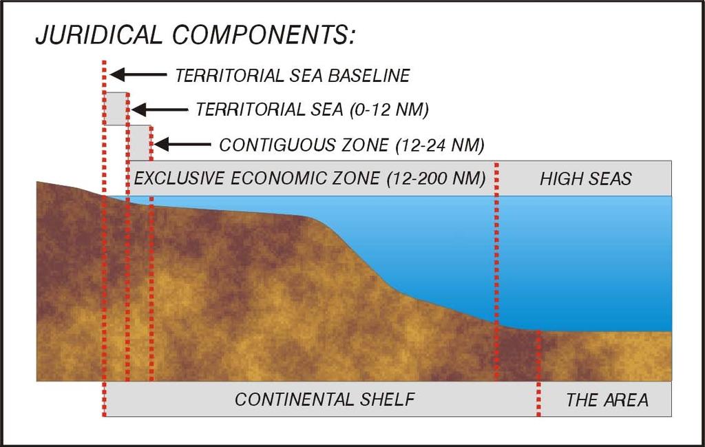
Non-living Resources of the OCS. Harald Brekke NPD
 Non-living Resources of the OCS Harald Brekke NPD The Continental Shelf and the Area http://www.grida.no/publications/shelf-last-zone/ Outer Continental Shelf Example http://www.grida.no/publications/shelf-last-zone/
Linking Global and Regional Levels in the Management of Marine Areas Beyond National Jurisdiction
 Linking Global and Regional Levels in the Management of Marine Areas Beyond National Jurisdiction South Atlantic Region Session 4: «Experiences, Priorities and Opportunities in the South Atlantic and Indian
Mapping in the Arctic Ocean in Support of a Potential Extended Continental Shelf
 Mapping in the Arctic Ocean in Support of a Potential Extended Continental Shelf Larry A. Mayer, Andrew A. Armstrong and James V. Gardner Center for Coastal & Ocean Mapping-Joint Hydrographic Center University
Outline of presentation
 - lessons learnt from precedent cases of establishing the s Outline of presentation Extending Ireland s continental shelf jurisdiction to the outer s in the Porcupine Abyssal Plain: progress, issues and
The Relevance of Hydrography to UNCLOS; an Indonesian Perspective By: Prof. Dr. Hasjim Djalal, MA*
 The Relevance of Hydrography to UNCLOS; an Indonesian Perspective By: Prof. Dr. Hasjim Djalal, MA* As I understand it, the theme of this 6 th ABLOS Conference 2010 is Contentious Issues in UNCLOS- surely
The IHPT Marine Spatial Data infrastructure and its contribution to the INSPIRE Directive
 The IHPT Marine Spatial Data infrastructure and its contribution to the INSPIRE Directive INSPIRE - GWF 2015 - Coastal & Marine session Lisbon Congress Center, Portugal - Thursday, 28 May 2015 Summary
The Continental Shelf Beyond 200 Nautical Miles in the Arctic Basin *
 717 The Continental Shelf Beyond 200 Nautical Miles in the Arctic Basin * Jianjun Gao ** Résumé Cet article traite de la difficile détermination des droits des États côtiers de l océan Arctique au-delà
RECENT DEVELOPMENT WHAT LIES BENEATH: THE CLCS AND THE RACE TO LAY CLAIM OVER THE ARCTIC SEABED I. ISSUES
 RECENT DEVELOPMENT WHAT LIES BENEATH: THE CLCS AND THE RACE TO LAY CLAIM OVER THE ARCTIC SEABED I. ISSUES Territorial claim over the Arctic Ocean has long been a topic of debate between various countries
PRELIMINARY INFORMATION
 PRELIMINARY INFORMATION INDICATIVE OF THE OUTER LIMITS OF THE CONTINENTAL SHELF AND DESCRIPTION OF THE STATUS OF PREPARATION OF MAKING A SUBMISSION TO THE COMMISSION ON THE LIMITS OF THE CONTINENTAL SHELF
ARTICLE. Defining Canada s Extended Continental Shelves. GEOSCIENCE CANADA Volume 38 Number 2 June
 GEOSCIENCE CANADA Volume 38 Number 2 June 2011 85 ARTICLE Defining Canada s Extended Continental Shelves Jacob Verhoef 1, David Mosher 1, and Steve Forbes 2 1 Geological Survey of Canada Natural Resources
Law of the Sea Symposium, February, 2016, TOKYO International Law for the Resources of the Sea
 Law of the Sea Symposium, 16-17 February, 2016, TOKYO International Law for the Resources of the Sea Segment 2 Governance of Resources of the Continental Shelf (including extended continental shelf) Introduction
ARTICLE 76: THE RIDGE ISSUE
 ARTICLE 76: THE RIDGE ISSUE by Alan EVANS 1, Chris CARLETON 2 and Lindsay PARSON 1 Address 1; Address 2; Southampton Oceanography Centre United Kingdom Hydrographic Office European Way Admiralty Way Southampton
Classification of Seafloor Highs according to UNCLOS article 76
 Faculty of Law Classification of Seafloor Highs according to UNCLOS article 76 How the practice of the CLCS on seafloor highs relates to UNCLOS article 76 interpreted in accordance with articles 31 and
The Future of International Institutional Arrangements in the Arctic: Foggy Horizons, Sea of Challenges
 The Future of International Institutional Arrangements in the Arctic: Foggy Horizons, Sea of Challenges Professor David L. VanderZwaag Canada Research Chair in Ocean Law and Governance Marine & Environmental
FAMOS for YOPP Forum for Arctic Modeling and Observational Synthesis (FAMOS) for Year of Polar Prediction (YOPP)
 for Year of Polar Prediction (YOPP)") FAMOS for YOPP Forum for Arctic Modeling and Observational Synthesis (FAMOS) for Year of Polar Prediction (YOPP) Andrey Proshutinsky (Woods Hole Oceanographic Institution) and research FAMOS team YOPP-Summit
FAMOS for YOPP Forum for Arctic Modeling and Observational Synthesis (FAMOS) for Year of Polar Prediction (YOPP) Andrey Proshutinsky (Woods Hole Oceanographic Institution) and research FAMOS team YOPP-Summit
Korean Arctic Research 2015 update
 FARO Annual Meeting, ASSW 2016 Fairbanks, Alaska, 12 March 2016 Korean Arctic Research 2015 update International Cooperation Department Korea Polar Research Institute Outline KOPRI and Korean Arctic research;
ARCTIC SPATIAL DATA INFRASTRUCTURE
 CAFF Strategy Series No. 1 January 2011 ARCTIC SPATIAL DATA INFRASTRUCTURE CONCEPT PAPER ARCTIC COUNCIL Acknowledgements The Conservation of Arctic Flora and Fauna (CAFF) is a Working Group of the Arctic
How to Deal with Maritime Boundary Uncertainty in Oil and Gas Exploration and Production Areas*
 The University of Texas School of Law Presented: International Upstream Energy Transactions January 17-18, 2013 Houston, TX How to Deal with Maritime Boundary Uncertainty in Oil and Gas Exploration and
DeepSea Minerals Research in Indonesia : Status and Challenges
 KEMENTERIAN MINISTRY OF ENERGY ENERGI AND DAN MINERAL SUMBER RESOURCES DAYA MINERAL REPUBLIK REPUBLIC OF INDONESIA DeepSea Minerals Research in Indonesia : Status and Challenges Noor C.D Aryanto and Ediar
Coastal State Sovereignty in the Arctic Offshore: Is it Compatible with the Concept of a Borderless North?
 Coastal State Sovereignty in the Arctic Offshore: Is it Compatible with the Concept of a Borderless North? A position paper presented for the 4 th NRF Open Meeting in Oulu, Finland and Luleå, Sweden, October
Portuguese Task Group for the Extension of the Continental Shelf (EMEPC)
") Portuguese Task Group for the Extension of the Continental Shelf (EMEPC) Teresa Rafael November 13 th 2017 DGRM Agenda 1. EMEPC competences 2. Initial Assessment Report - Extended continental shelf 3.
Portuguese Task Group for the Extension of the Continental Shelf (EMEPC) Teresa Rafael November 13 th 2017 DGRM Agenda 1. EMEPC competences 2. Initial Assessment Report - Extended continental shelf 3.
BUDGET. Investigation of natural sand transport on the Belgian continental shelf
 BUDGET Investigation of natural sand transport on the Belgian continental shelf Funded by Federal Office for Scientific, Technical and Cultural Affairs Program: Sustainable Management of the North Sea
8 th Arctic Regional Hydrographic Commission Meeting September 2018, Longyearbyen, Svalbard Norway
 8 th Arctic Regional Hydrographic Commission Meeting 11-13 September 2018, Longyearbyen, Svalbard Norway Status Report of the Arctic Regional Marine Spatial Data Infrastructures Working Group (ARMSDIWG)
Ocean Governance and the Japanese Basic Act on Ocean Policy
 Ocean Governance and the Japanese Basic Act on Ocean Policy Hiroshi Terashima Executive Director Ocean Policy Research Foundation 14 April 2009 The United Nations Nippon Foundation Fellowship Programme
Arctic Hydrographic Adequacy an Update
 Arctic Hydrographic Adequacy an Update Lt Cmd. Samuel F. Greenaway 1 and Amber Batts 1,2 1. NOAA Office of Coast Survey Development Lab, Hydrographic Systems & Technology Branch, Silver Spring, Maryland,
Paleoceanography,, Seabed Morphology, and Geologic Framework of the Northwest Passage ArcticNet Project 1.6
 Paleoceanography,, Seabed Morphology, and Geologic Framework of the Northwest Passage ArcticNet Project 1.6 Robbie Bennett, Steve Blasco, Brian MacLean, Andre Rochon, John Hughes-Clarke, Jonathan Beaudoin,
Hydrographic National Report of Denmark
 18th Conference Agenda item B.2 Tallinn, Estonia National report 16-18 September 2013 Denmark Hydrographic National Report of Denmark Marts 2013 1. Hydrographic Office January 1, 2013 Kort & Matrikelstyrelsen
Country Fiche Latvia.
 Country Fiche Latvia 1. General information Marine waters under Latvian jurisdiction include inland sea waters, territorial sea (12 nautical miles from the baseline) and exclusive economic zone (EEZ) waters.
Law, Science, and the Continental Shelf: The Russian Federation and the Promise of Arctic Cooperation
 American University International Law Review Volume 25 Issue 2 Symposium: Russia and the Rule of Law: New Opportunities in Domestic and International Affairs Article 4 2010 Law, Science, and the Continental
28 January 2013 Community White Paper for Arctic Observing Summit 2013
 Arctic Ocean Bathymetry: A required geospatial framework 1 Martin Jakobsson, 2 Larry Mayer, and 2 David Monahan Department of Geological Sciences, Stockholm University, Sweden Center for Coastal and Ocean
Canadian activities in the Pacific Arctic Region: 2016 icebreaker plans.
 Canadian activities in the Pacific Arctic Region: 2016 icebreaker plans. Pacific Arctic Group meeting Arctic Science Summit Week, Fairbanks, Alaska 13 March 2016 CCGS Louis S. St-Laurent UNCLOS misson:
Coastal State Sovereignity in the Arctic Offshore: Is it Compatible with the Concept of a Borderless North?
 77 Coastal State Sovereignity in the Arctic Offshore: Is it Compatible with the Concept of a Borderless North? Ron Macnab Geological Survey of Canada (Retired) Introduction The notion of a Borderless North
Towards international cooperation in the development of Marine Spatial Plans for the North Pacific: economic, social, and environmental dimensions
 Towards international cooperation in the development of Marine Spatial Plans for the North Pacific: economic, social, and environmental dimensions A.V. Sereda, V.B. Lobanov V.I. Il ichev Pacific Oceanological
Z046 Seismic Characteristics of Gas Migration Structures on the North Atlantic Margin Imaged by High-resolution 3D Seismic
 Z046 Seismic Characteristics of Gas Migration Structures on the North Atlantic Margin Imaged by High-resolution 3D Seismic O.K. Eriksen* (P-Cable 3D Seismic), C. Berndt (IFM-GEOMAR), S. Buenz (University
Pacific Islands Regional Maritime Boundaries Project the latest Update. Malakai Vakautawale (Mr) Maritime Boundaries Adviser
 Maritime Boundaries Adviser") Pacific Islands Regional Maritime Boundaries Project the latest Update Malakai Vakautawale (Mr) Maritime Boundaries Adviser Consortium Partners 2 What we do? Provide technical advice and support on MB
Pacific Islands Regional Maritime Boundaries Project the latest Update Malakai Vakautawale (Mr) Maritime Boundaries Adviser Consortium Partners 2 What we do? Provide technical advice and support on MB
The Place of Joint Development in the Sustainable Arctic Governance
 The Place of Joint Development in the Sustainable Arctic Governance ShipArc2015: Joint WMU - IMO - Arctic Council International Conference on Safe and Sustainable Shipping in a Changing Arctic Environment
Geological Survey of Canada Lands and Minerals Sector Natural Resources Canada OneGeology, June 2018
 Geological Survey of Canada Lands and Minerals Sector Natural Resources Canada OneGeology, June 2018 Geological Survey of Canada Mission The Geological Survey of Canada provides public geoscience knowledge
Deep-Water Flow over the Lomonosov Ridge in the Arctic Ocean
 AUGUST 2005 N O T E S A N D C O R R E S P O N D E N C E 1489 Deep-Water Flow over the Lomonosov Ridge in the Arctic Ocean M.-L. TIMMERMANS, P. WINSOR, AND J. A. WHITEHEAD Woods Hole Oceanographic Institution,
Options in Capacity Building. Underpinning the Blue Economy. Slide 1/78. Derrick R. Peyton. 14 th MACHC Meeting. IIC Technologies. December 9-13, 2013
 Options in Capacity Building Underpinning the Blue Economy Derrick R. Peyton IIC Technologies 14 th MACHC Meeting December 9-13, 2013 Slide 1/78 Overview Blue Economy Defined Challenges (SDI, MSDI, Standards)
Maritime delimitation and environmental protection of fragile seas
 Gemma Andreone Istituto di Studi Giuridici Internazionali - Consiglio Nazionale delle Ricerche Marsafenet Cost Action Chair - www.marsafenet.org Maritime delimitation and environmental protection of fragile
Limits in the Seas. No. 96 June 6, Greece Italy. Continental Shelf Boundary. (Country Codes: GR-IT)
") Limits in the Seas No. 96 June 6, 1982 Greece Italy Continental Shelf Boundary (Country Codes: GR-IT) The Geographer Office of the Geographer Bureau of Intelligence and Research INTERNATIONAL BOUNDARY
Limits in the Seas No. 96 June 6, 1982 Greece Italy Continental Shelf Boundary (Country Codes: GR-IT) The Geographer Office of the Geographer Bureau of Intelligence and Research INTERNATIONAL BOUNDARY
FAST- CHANGING MARITIME ARCTIC
 Proceedings THE FAST- CHANGING MARITIME ARCTIC By Captain Lawson W. Brigham, U.S. Coast Guard (Retired) Globalization, climate change, and geopolitics converge in this already challenging region. 54 The
The Arctic SDI - A circumpolar initiative -
 Arctic The Arctic - A circumpolar initiative - ULI, Uppsala October 4, 2011 www. arctic-sdi.org Owe Palmér Martin Skedsmo Project Management Group Lantmäteriet Norwegian Mapping Authority October 2011