THE MEASUREMENT AND ANALYSIS OF BATHYMETRY, MORPHOLOGY, AND SEDIMENT THICKNESS
|
|
|
- Barrie Lucas
- 6 years ago
- Views:
Transcription
1 THE MEASUREMENT AND ANALYSIS OF BATHYMETRY, MORPHOLOGY, AND SEDIMENT THICKNESS Ron Macnab Geological Survey of Canada (Retired)
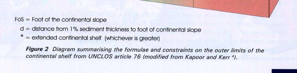
2 OUTLINE OF PRESENTATION Principles and practice of: Echo-sounding Seismic reflection and refraction Database and GIS tools Test of Appurtenance Foot of Slope 2500 metre isobath Gardiner Line Case studies and examples Discussion, Q & A
3 MEASURING THE DEPTH OF WATER: PRINCIPLES, PRACTICES, AND PROBLEMS In the Article 76 context, water depth is necessary: To locate the Foot of the Slope (primarily a morphological exercise) To locate the 2500 m Isobath (primarily a bathymetric exercise)
4 THE BLUE BOOK Continental Shelf Limits: the Scientific and Technical Interface Chapter 9 (Tony Laughton & Steve Shipman) Historical Methods of Depth Measurement Chapter 10 (John Hughes Clarke) Present-Day Methods of Depth Measurement Chapter 11 (David Monahan) Interpretation of Bathymetry
5 IHO MANUAL ON HYDROGRAPHY


6 THE MEASUREMENT OF DEPTH IS ACTUALLY A MEASUREMENT OF ELAPSED TIME
7 THE VELOCITY OF SOUND IN SEAWATER IS VARIABLE Function of Temperature, Salinity, Pressure Varies from the sea surface to the sea floor Varies from one location to another Varies from one season to another These variations must be taken into account because they can introduce significant errors in the measurement of depth
8 CORRECTING FOR VARIATIONS IN SOUND VELOCITY Refer to published Tables of Corrections Measure sound velocity in situ: Observations of Temperature, Salinity, Pressure throughout the water column Direct measurement of velocity profile Acoustical techniques
9 POSITIONING TECHNIQUES IN MARINE SURVEYING Databases used for determining OCS limits may represent a mix of historic and modern observations. Most likely, these observations will have been collected with navigational systems that have evolved over the years. It is important to understand the principles and limitations of early navigation systems, in order to assess the suitability of historic observations for Article 76 purposes.
10 POSITIONING MARINE SURVEYS: HISTORIC METHODS I Discussed in Cook & Carleton, Chapter 7: Astronomic observations Intermittent Sun - accurate to 3 km Stars - accurate to 2 km Deduced reckoning (DR) Continuous - based on course & speed made good Subject to many and varied errors Land-based radionavigation Continuous accuracy within tens to hundreds of metres Circular measuring distances to known points Hyperbolic - measuring time differences between signals High frequency - short range, high accuracy Low frequency - long range, low accuracy
11 POSITIONING MARINE SURVEYS: HISTORIC METHODS II Discussed in Cook & Carleton, Chapter 7: Transit satellite Periodic Accurate to 100 m Inertial Integration of horizontal and vertical accelerations Subject to many and varied errors, particularly drift Integrated systems Combining best of DR, radionavigation, Transit, inertial Continuous Accuracy - tens to hundreds of m
12 POSITIONING MARINE SURVEYS: MODERN METHODS Discussed in Cook & Carleton, Chapter 8 - (GPS): Standard Positioning Service (SPS) civilian Coarse/Acquisition (C/A) code m hor, 150 m vert Selective Availability (SA) - C/A signal degraded SA removed May accuracy improved to m Precise Positioning Service (PPS) - encrypted, for military use Precise (P) code - 16 m Differential GPS Fixed reference station derives corrections for mobile receivers Accuracy 1-5 m Carrier phase measurements Future potential for real-time navigation to the cm level
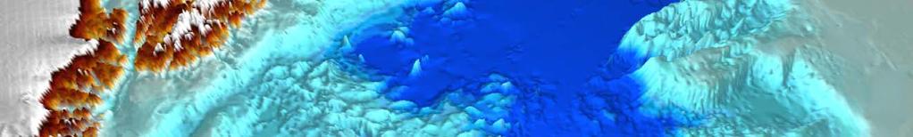
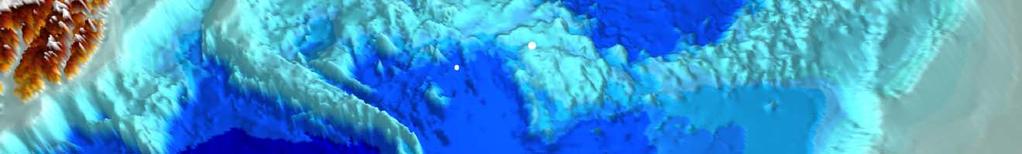
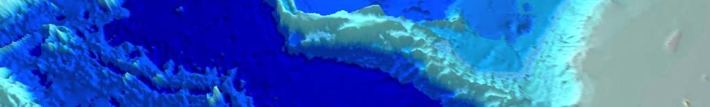
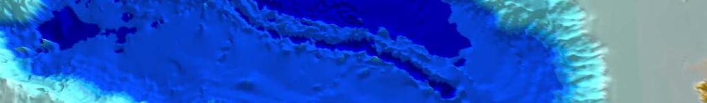
13 MAPPING THE DEPTH OF THE SEA: ACOUSTIC METHODS Single beam Depths at single points beneath the vessel Sidescan sonar Bottom characteristics (not depths) to either side of vessel Multibeam Multiple depths at points beneath and to either side of the vessel
14 SINGLE (NARROW) BEAM MAPPING John Hughes Clarke, UNB

15 SINGLE (NARROW) BEAM WITH SIDESCAN SONAR John Hughes Clarke, UNB

16 MULTIBEAM MAPPING John Hughes Clarke, UNB
17 SINGLE (WIDE) BEAM VS MULTIBEAM
18 SEABED PORTRAYED FROM WIDE BEAM SOUNDINGS ALONG RANDOM TRACKLINES
19 SEABED PORTRAYED FROM WIDE BEAM SOUNDINGS ALONG RANDOM TRACKLINES SAME SEABED PORTRAYAL, ENHANCED WITH MULTIBEAM SOUNDINGS


20 HOW BEAMWIDTH AFFECTS OUR PERCEPTION OF THE SEABED IHO Manual on Hydrography
21 Hyperbolic Echoes Bottom Minimum Wavelength NOTE : as long as target below transducer, does not bias the shallowest depth estimation BUT : does significantly limit minimum resolvable horizontal Wavelength. A result of the projected beam width. John Hughes Clarke, UNB
22 Bottom Slope Effect Results in underestimation of bottom slopes Representation of a Trough (e.g.: dredged channel) Can have consequences for Dredge payment as underestimates Volume of sediment removed. John Hughes Clarke, UNB
23 Side Swipes Three profiles: 1. Directly over the target 2. Offset but over the target 3. Offset, never over the target Note true elevation generally underestimated And location imperfectly defined John Hughes Clarke, UNB

24 COMPARING NARROW- AND WIDE- BEAM PORTRAYALS OF THE SEABED IHO Manual on Hydrography

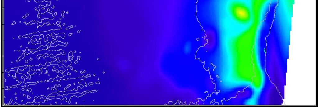
 Depths: 25-45m Bedford Basin")
25 NARROW BEAMS = HIGHER RESOLUTION Simrad EM1000 (2.4 x 3.3 deg. beams) Simrad EM3000 (1.5 x 1.5* deg. beams) Depths: 25-45m Bedford Basin John Hughes Clarke, UNB

26 BATHYMETRY DERIVED FROM SATELLITE ALTIMETRY

27 WORLD BATHYMETRY FROM SATELLITE ALTIMETRY
28 BATHYMETRY DERIVED FROM SATELLITE ALTIMETRY Bathymetric maps derived from satellite altimetry cover most of the globe. They are very useful for presenting regional views and for general analysis. These maps cannot resolve seabed features to better than about 8 km, with depth inaccuracies of 100s of metres. The CLCS has declared that it will not accept such maps in support of submissions.
29 AEGIR RIDGE DEPTHS DERIVED FROM SATELLITE ALTIMETRY Peter Vogt, USNRL

30 AEGIR RIDGE DEPTHS MEASURED WITH MULTIBEAM DEPTHS DERIVED FROM SATELLITE ALTIMETRY Peter Vogt, USNRL


31 BATHYMETRY DERIVED FROM SEISMIC MEASUREMENTS Deemed acceptable by CLCS, but only as secondary data Conventional annotation - TWT Converted annotation - Depth John Hughes Clarke, UNB
32 MEASURING THE THICKNESS OF SEDIMENT: PRINCIPLES, PRACTICES, AND PROBLEMS In the Article 76 context, sediment thickness is needed to locate the Gardiner Line, i.e. the line where the thickness of sedimentary material is equal to 1% of the distance back to the foot of slope. Several considerations that apply to the measurement of bathymetry also apply to the measurement to sediment thickness, e.g. choice of frequency, acoustic propagation errors, etc.
33 THE BLUE BOOK Continental Shelf Limits: the Scientific and Technical Interface Chapter 12 (Kasuga, Nishizawa, Ohara, Kusunoki, and Katsura) Seismic Reflection and refraction Methods


34 A PASSIVE CONTINENTAL MARGIN Wood et al. 2003

35 Wood et al. 2003
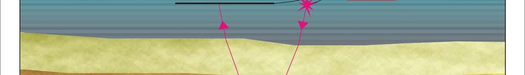
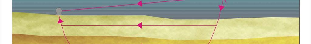
36 THE SEISMIC REFLECTION TECHNIQUE MEASURES THE TWO-WAY TRAVEL TIMES OF SOUND PULSES THROUGH SEDIMENT LAYERS THAT LIE BENEATH THE OCEAN FLOOR. BUT THOSE TRAVEL TIMES NEED TO BE COMBINED WITH THE SOUND VELOCITY FOR EACH LAYER IN ORDER TO YIELD VALUES OF SEDIMENT THICKNESS.
37 THE SEISMIC REFRACTION TECHNIQUE MEASURES THE HORIZONTAL TRAVEL TIMES OF SOUND PULSES THROUGH SEDIMENT LAYERS THAT LIE BENEATH THE OCEAN FLOOR. COMBINING THOSE TRAVEL TIMES WITH THE KNOWN DISTANCE BETWEEN SOUND SOURCE AND RECEIVER YIELDS THE SOUND VELOCITY FOR EACH LAYER.


38


39 VELOCITY ANALYSIS CALCULATING SOUND VELOCITIES IN SEDIMENT Requires complex sensor configuration and extensive computer processing
40 MEASURING SEDIMENT THICKNESS FOR ARTICLE 76 Single channel system will suffice if only depth to acoustic basement is being sought this is cheap and simple to operate. Simple multichannel system will yield stratigraphic information in addition to depth to basement, but refraction experiments may be needed to calculate sound velocities this is more expensive and complex. Industry multichannel system will yield detailed cross-section of sediment down to the basement this is very expensive and may yield more information than is required.
41 GATHER NEW DATA, OR USE EXISTING DATA? Questions to ask when making the decision: Availability, coverage, and quality of existing holdings? Prospects for building a better article 76 case with new data? Time and effort to collect new data? Cost of collecting new data?
42 SOURCES OF EXISTING DATA
43 GEBCO (BLUE) AND IBC (RED) SHEETS


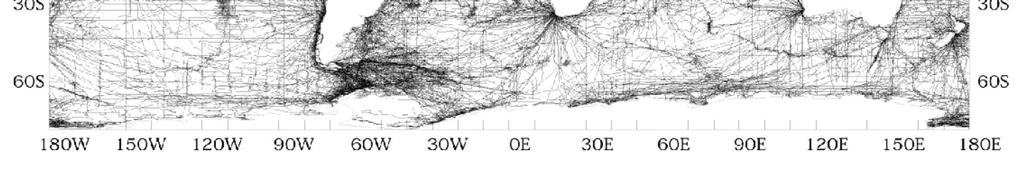
44 GLOBAL TRACKLINE HOLDINGS AT NGDC
45
46
47 GLOBAL SEDIMENT THICKNESS GRID NGDC
48 BASIC SURVEY DESIGN GET EXPERT HELP! SINGLE BEAM MULTIBEAM IHO Manual on Hydrography
49 DATABASE AND GIS TOOLS Proprietary tools exist for archiving and managing the geo-referenced data sets that are needed for Article 76 work. These tasks are common to many geographic and geoscientific endeavours, so the tools are common and well developed. Fewer proprietary tools exist for analyzing these georeferenced data sets for Article 76 purposes and for visualizing the outcome. These tasks are unique to Article 76 and hence represent a smaller market for software developers. Some coastal States have developed their own tools in house. A coastal State should seek expert advice in the selection and procurement of these tools, taking its unique circumstances into account: there is no one size fits all solution.
50 THE TEST OF APPURTENANCE The submitting State must demonstrate that a portion of its continental landmass extends beneath the sea and comprises a genuine natural prolongation The CLCS seems to prefer a geomorphological definition of the natural prolongation There may be some scope for invoking evidence to the contrary, e.g. geological or geophysical information, in defining the natural prolongation
51 SOME ILLUSTRATIONS OF THE TEST OF APPURTENANCE Islands located beyond the continental EEZs of their parent States: Ecuador and the Galapagos Islands San Felix and San Ambrosio Islands, Chile Azores and Madeira Islands, Portugal Trinidade and Martin Vaz Islands, Brazil

52 ECUADOR AND THE GALAPAGOS ISLANDS Costa Rica Colombia Ecuador


53 SAN FELIX AND SAN AMBROSIO ISLANDS, CHILE


54 AZORES AND MADEIRA ISLANDS, PORTUGAL


55 TRINIDADE AND MARTIN VAZ ISLANDS, BRAZIL


56 TRINIDADE AND MARTIN VAZ ISLANDS, BRAZIL: CLAIMED OCS LIMIT
57 NATURAL PROLONGATIONS AND THE TEST OF APPURTENANCE OFF ECUADOR Acceptable? Not acceptable?

58 THE ARCTIC OCEAN: MORPHOLOGICAL BREAKS IN NATURAL PROLONGATIONS Canada Alpha-Mendeleev Ridge Greenland Russia Lomonosov Ridge
59 THE FOOT OF THE SLOPE The point of departure for the two Formula Lines of Article 76 Defined as the point where the seabed undergoes a maximum change of gradient Not unambiguous: the FoS point may be difficult to determine with any precision, or there may be multiple contending points to choose from Important to document carefully the choice of FoS point and reasons why it was selected, in case of a query or challenge by the CLCS


60 AMBIGUITIES IN LOCATING THE FOOT OF SLOPE Two databases describing the same section of the seafloor: note multiple FOS choices in each profile, lack of agreement between profiles

61 LOCATING THE FOOT OF THE SLOPE Fitting a smooth curve to the bathymetric profile POINT OF OF MAXIMUM CHANGE OF OF BOTTOM GRADIENT
62 LOCATING THE FOOT OF THE SLOPE Fitting straight lines to the bathymetric profile POINT OF OF MAXIMUM CHANGE OF OF BOTTOM GRADIENT
63 POSSIBLE FOS PROFILES OFF ECUADOR AND THE GALAPAGOS ISLANDS


64 BATHYMETRIC PROFILE AND FOOT OF SLOPE POINTS, CARNEGIE RIDGE
65 POSSIBLE FOS PROFILES OFF ECUADOR AND THE GALAPAGOS ISLANDS


66 BATHYMETRIC PROFILE AND FOOT OF SLOPE POINT, COLON RIDGE


67 POSSIBLE FOS POINTS AND LINES
68 THE 2500 METRE ISOBATH Key to constructing one of the constraint or cutoff lines of Article 76 Requires more measurement accuracy than does the determination of FoS points May apply only partially or not at all, depending on the configuration of the seabed adjacent to the submitting coastal State


69 2500 M ISOBATH NOT APPLICABLE 2500 m isobath 2500 m M FoS 200 M limit 350 M limit

70 2500 M ISOBATH PARTIALLY APPLICABLE THE ARCTIC SITUATION 350 NM CUTOFF 2500 M ISOBATH PLUS 100 NM PARTIAL SEGMENTS OF 2500 M PLUS 100 NM 2500 M ISOBATH
71 THE GARDINER LINE The point where sediment thickness is equal to 1% of the distance back to the FoS One of the Formula Lines of Article 76 An attempt to devise a criterion that could be applied consistently to the sedimentary material lying beneath the seabed adjacent to a submitting State Based on simplifying assumptions that bear little relationship to physical reality


72 AMBIGUITIES IN LOCATING THE GARDINER LINE Upper figure: the principle. Lower figure: the practice.


73 EXAMPLE: SEABED SEDIMENT OFF ANGOLA


74 A PROFILE ACROSS THE SEDIMENT OFF ANGOLA 1% Thickness Line


75 ARTICLE 76 FORMULA LINES OFF ANGOLA
76 IN CONCLUSION If making new measurements of bathymetry and sediment thickness, choose appropriate techniques. If using available databases, review their contents carefully to verify their suitability. Choose database and GIS tools that are adequate to the tasks. Document carefully all data sets and analytical procedures. Develop and maintain an awareness of how other States are developing their own OCS limits.
77 THANK YOU!
The french national programme for claiming continental shelf beyond 200 Miles
 The french national programme for claiming continental shelf beyond 200 Miles Using global bathymetric models in the context of an Extended Continental Shelf submission EXTRAPLAC Using Global Bathymetric
OUTER CONTINENTAL SHELF CLAIMS IN THE ARCTIC. Presentation given by Dr. Kamrul Hossain ASA University Bangladesh 15 March 2010
 OUTER CONTINENTAL SHELF CLAIMS IN THE ARCTIC Presentation given by Dr. Kamrul Hossain ASA University Bangladesh 15 March 2010 Contents Historical background of the continental shelf Concept of continental
CONFERENCE OF PARLIAMENTARIANS OF THE ARCTIC REGION. UN LOS Convention and the extended continental shelf in the Arctic
 CONFERENCE OF PARLIAMENTARIANS OF THE ARCTIC REGION UN LOS Convention and the extended continental shelf in the Arctic Presentation given by Dr. Kamrul Hossain Finnish Parliament 18 November 2009 Contents
UNCLOS Article 76- Formulae and constraint lines
 UNCLOS Article 76- Formulae and constraint lines Dr Lindsay Parson (UNCLOS Group, National Oceanography Centre, UK) ABLOS TUTORIAL SESSION - Article 76 of UNCLOS 10th October 2005 IHO/IAG/IOC Advisory
COMPLICATIONS IN DELIMITING THE OUTER CONTINENTAL SHELF. Ron Macnab Geological Survey of Canada (Retired)
") COMPLICATIONS IN DELIMITING THE OUTER CONTINENTAL SHELF Ron Macnab Geological Survey of Canada (Retired) DISCLAIMER The contents of this presentation are the author s personal views only, and do not represent
COMPLICATIONS IN DELIMITING THE OUTER CONTINENTAL SHELF Ron Macnab Geological Survey of Canada (Retired) DISCLAIMER The contents of this presentation are the author s personal views only, and do not represent
ARTICLE 76: THE RIDGE ISSUE
 ARTICLE 76: THE RIDGE ISSUE by Alan EVANS 1, Chris CARLETON 2 and Lindsay PARSON 1 Address 1; Address 2; Southampton Oceanography Centre United Kingdom Hydrographic Office European Way Admiralty Way Southampton
Seafloor Mapping in the High Arctic: The Challenges and the Joys
 Seafloor Mapping in the High Arctic: The Challenges and the Joys Larry Mayer Center for Coastal and Ocean Mapping / NOAA- UNH Joint Hydrographic Center University of New Hampshire, USA Martin Jakobsson
Challenges of Collecting Data for Article 76 in Ice Covered Waters of the Arctic
 Challenges of Collecting Data for Article 76 in Ice Covered Waters of the Arctic 5 th ABLOS Conference Monaco October 16, 2008 Richard MacDougall - Canada Jacob Verhoef - Canada Wendell Sanford - Canada
EXECUTIVE SUMMARY A SUBMISSION OF DATA AND INFORMATION ON THE OUTER LIMITS OF THE CONTINENTAL SHELF OF THE REPUBLIC OF NIGERIA PURSUANT TO
 EXECUTIVE SUMMARY A SUBMISSION OF DATA AND INFORMATION ON THE OUTER LIMITS OF THE CONTINENTAL SHELF OF THE REPUBLIC OF NIGERIA PURSUANT TO PART VI OF AND ANNEX II TO THE UNITED NATIONS CONVENTION ON THE
Digital Elevation Model (DEM) of Sable Island Bank and adjacent areas
 of Sable Island Bank and adjacent areas") GEOLOGICAL SURVEY OF CANADA OPEN FILE 5348 Digital Elevation Model (DEM) of Sable Island Bank and adjacent areas K.J. Webb and E.L. King 2014 GEOLOGICAL SURVEY OF CANADA OPEN FILE 5348 Digital Elevation
GEOLOGICAL SURVEY OF CANADA OPEN FILE 5348 Digital Elevation Model (DEM) of Sable Island Bank and adjacent areas K.J. Webb and E.L. King 2014 GEOLOGICAL SURVEY OF CANADA OPEN FILE 5348 Digital Elevation
NEW TOOLS TO IMPROVE DESKTOP SURVEYS
 NEW TOOLS TO IMPROVE DESKTOP SURVEYS Pablo Vengoechea (Telemediciones S.A.), Jorge O. García (Telemediciones S.A.), Email: Telemediciones S.A. / Cra. 46 94-17 Bogotá D.C.
HOW TO DEFINE THE BASE OF THE SLOPE IN LOW GRADIENT PASSIVE MARGINS? BRAZILIAN CONTINENTAL SHELF PROJECT (LEPLAC)
") HOW TO DEFINE THE 1 BASE OF THE SLOPE IN LOW GRADIENT PASSIVE MARGINS? BRAZILIAN CONTINENTAL SHELF PROJECT (LEPLAC) Izabel King Jeck Commander, DHN, Brazilian Navy izabel@dhn.mar.mil.br How to apply art.76
HOW TO DEFINE THE 1 BASE OF THE SLOPE IN LOW GRADIENT PASSIVE MARGINS? BRAZILIAN CONTINENTAL SHELF PROJECT (LEPLAC) Izabel King Jeck Commander, DHN, Brazilian Navy izabel@dhn.mar.mil.br How to apply art.76
Topic: Bathymetric Survey Techniques. (a) Single-beam echo-sounders (SBES) (b) Multi-beam echo-sounders (MBES)
 Single-beam echo-sounders (SBES) (b) Multi-beam echo-sounders (MBES)") Topic: Bathymetric Survey Techniques (a) Single-beam echo-sounders (SBES) (b) Multi-beam echo-sounders (MBES) Bathymetry is the measurement of water depths - bathymetry is the underwater equivalent of
Topic: Bathymetric Survey Techniques (a) Single-beam echo-sounders (SBES) (b) Multi-beam echo-sounders (MBES) Bathymetry is the measurement of water depths - bathymetry is the underwater equivalent of
FOOT OF THE CONTINENTAL SLOPE IN ARTICLE 76
 FOOT OF THE CONTINENTAL SLOPE IN ARTICLE 76 Vaughan Stagpoole, Institute of Geological & Nuclear Sciences, Lower Hutt, New Zealand, v.stagpoole@gns.cri.nz Ray Wood, Institute of Geological & Nuclear Sciences,
Bathymetric data acquisition in Arctic waters
 Bathymetric data acquisition in Arctic waters within the Danish Continental Shelf Project Morten Sølvsten, Uni Bull, Richard Pedersen & Christian Marcussen Arctic-Antarctic Seafloor Mapping Meeting 2011
12/11/2013& egm502 seafloor mapping
 egm502 seafloor mapping lecture 13 multi-beam echo-sounders The majority of the current charts of the ocean floors have been produced from single beam echo-sounder data. Even though these data have been
Ocean Basins, Bathymetry and Sea Levels
 Ocean Basins, Bathymetry and Sea Levels Chapter 4 Please read chapter 5: sediments for next class and start chapter 6 on seawater for Thursday Basic concepts in Chapter 4 Bathymetry the measurement of
National Marine Sanctuary Program
 National Marine Sanctuary Program NMSP/USGS Joint Seabed Mapping Initiative: September 2004 AA National Ocean Service National Marine Sanctuaries Interim Report September 2004 Background: Since 2002,
Marine Geospatial Software: Generating Economic Benefits from Hydrographic Data and Calculation of Maritime Boundaries
 Marine Geospatial Software: Generating Economic Benefits from Hydrographic Data and Calculation of Serge LEVESQUE and Alexis CARDENAS, Canada Key words: marine geospatial data, hydrography, economic benefits,
Map shows 3 main features of ocean floor
 Map shows 3 main features of ocean floor 2017 Pearson Education, Inc. Chapter 3 Marine Provinces 2017 Pearson Education, Inc. 1 Chapter 3 Overview The study of bathymetry determines ocean depths and ocean
Chapter Overview. Bathymetry. Measuring Bathymetry. Measuring Bathymetry
 CHAPTER 3 Marine Provinces Chapter Overview The study of bathymetry determines ocean depths and ocean floor topography. Echo sounding and satellites are efficient bathymetric tools. Most ocean floor features
Outline of presentation
 - lessons learnt from precedent cases of establishing the s Outline of presentation Extending Ireland s continental shelf jurisdiction to the outer s in the Porcupine Abyssal Plain: progress, issues and
Bathymetry Measures the vertical distance from the ocean surface to mountains, valleys, plains, and other sea floor features
 1 2 3 4 5 6 7 8 9 10 11 CHAPTER 3 Marine Provinces Chapter Overview The study of bathymetry determines ocean depths and ocean floor topography. Echo sounding and satellites are efficient bathymetric tools.
Figure 3.1: Illustration showing the bathymetry s role for the tsunami propagation following the earth quake 26 December 2004 outside of Sumatra.
 Figure 3.1: Illustration showing the bathymetry s role for the tsunami propagation following the earth quake 26 December 2004 outside of Sumatra. The left globe shows the seafloor bathymetry as portrayed
Joint Hydrographic Center, National Oceanic and Atmospheric Administration, Durham, NH 03824, USA
 Future directions in hydrography using satellite-derived bathymetry Shachak Pe eri 1, Christopher Parrish 2, 3, Lee Alexander 1, Chukwuma Azuike 1, Andrew Armstrong 1,3 and Maryellen Sault 2 1 Center for
High-resolution Geophysical Mapping of Submarine Glacial Landforms
 High-resolution Geophysical Mapping of Submarine Glacial Landforms M. Jakobsson 1, J.A. Dowdeswell 2, M. Canals 3, B.J. Todd 4, E.K. Dowdeswell 2, K.A. Hogan 5 L.A. Mayer 6 1 Stockholm University, Sweden
Marine Science and Oceanography
 Marine Science and Oceanography Marine geology- study of the ocean floor Physical oceanography- study of waves, currents, and tides Marine biology study of nature and distribution of marine organisms Chemical
CONTINENTAL SHELF SUBMISSION OF ANGOLA - EXECUTIVE SUMMARY -
 CONTINENTAL SHELF SUBMISSION OF ANGOLA - EXECUTIVE SUMMARY - INDEX List of Figures 2 List of Tables 3 1 Introduction 5 2 Provisions of Article 76 7 3 Angolan Institutions responsible for the Submission
The Continental Shelf Project: An overview of research activities in the Arctic Ocean on behalf of the Kingdom of Denmark
 The Continental Shelf Project: An overview of research activities in the Arctic Ocean on behalf of the Kingdom of Denmark Geological Survey of Denmark and Greenland Ministry of Climate and Energy John
MAPS AND COORDINATES...
 Table of Contents 1 INTRODUCTION... 2 2 MAPS AND COORDINATES... 3 3 ADVISORY ASSISTANCE FROM COMMISSION MEMBERS... 3 4 PROVISIONS OF ARTICLE 76 INVOKED... 3 5 OUTSTANDING MARITIME DELIMITATIONS... 4 6
Changes in bottom morphology of Long Island Sound near Mount Misery Shoal as observed through Repeated Multibeam Surveys
 Changes in bottom morphology of Long Island Sound near Mount Misery Shoal as observed through Repeated Multibeam Surveys Laurie A. Zaleski Laurie.Zaleski@msrc.sunysb.edu Roger D. Flood rflood@notes.cc.sunysb.edu
Oceanography. Oceanography is the study of the deep sea and shallow coastal oceans.
 Oceanography Oceanography is the study of the deep sea and shallow coastal oceans. Studying the Ocean Floor To determine the shape and composition of the ocean floor, scientists use techniques such as
Article 76, variations in annotation and implementation seen in submission documents for the claim of Extended Continental Shelf
 Article 76, variations in annotation and implementation seen in submission documents for the claim of Extended Continental Shelf Mr. Shin Tani Chairman, IHO/IAG Advisory Board on the Law of the Sea (ABLOS)
Regional-scale understanding of the geologic character and sand resources of the Atlantic inner continental shelf, Maine to Virginia
 Regional-scale understanding of the geologic character and sand resources of the Atlantic inner continental shelf, Maine to Virginia Workshop on Dredging, Beach Nourishment and Bird Conservation Atlantic
Lecture Marine Provinces
 Lecture Marine Provinces Measuring bathymetry Ocean depths and topography of ocean floor Sounding Rope/wire with heavy weight Known as lead lining Echo sounding Reflection of sound signals 1925 German
Preliminary Information Indicative of the Outer Limits of the Continental Shelf Beyond 200 Nautical Miles of the People s Republic of China
 (Translation) Preliminary Information Indicative of the Outer Limits of the Continental Shelf Beyond 200 Nautical Miles of the People s Republic of China 1. The People s Republic of China ratified the
The IHPT Marine Spatial Data infrastructure and its contribution to the INSPIRE Directive
 The IHPT Marine Spatial Data infrastructure and its contribution to the INSPIRE Directive INSPIRE - GWF 2015 - Coastal & Marine session Lisbon Congress Center, Portugal - Thursday, 28 May 2015 Summary
Marine Geophysical Methods: What Can and Cannot Be Done to Iden8fy Hazards to Dredging & Marine Construc8on
 Marine Geophysical Methods: What Can and Cannot Be Done to Iden8fy Hazards to Dredging & Marine Construc8on Marine Geophysics Sham or Savior? Seen alternatively as the silver bullet or snake oil, marine
JOINT SUBMISSION TO THE COMMISSION ON THE LIMITS OF THE CONTINENTAL SHELF BY TUVALU, THE REPUBLIC OF FRANCE AND NEW ZEALAND (TOKELAU)
") JOINT SUBMISSION TO THE COMMISSION ON THE LIMITS OF THE CONTINENTAL SHELF BY TUVALU, THE REPUBLIC OF FRANCE AND NEW ZEALAND (TOKELAU) TABLE OF CONTENTS i. PREFACE... iii ii. LIST OF FIGURES... iv iii.
JOINT SUBMISSION TO THE COMMISSION ON THE LIMITS OF THE CONTINENTAL SHELF BY TUVALU, THE REPUBLIC OF FRANCE AND NEW ZEALAND (TOKELAU) TABLE OF CONTENTS i. PREFACE... iii ii. LIST OF FIGURES... iv iii.
Does Ascension Island have an outer continental shelf?
 Does Ascension Island have an outer continental shelf? Robin Cleverly UK Hydrographic Office Lindsay Parson NOC, Southampton (with Alan Evans, Peter Hunter, Rosemary Edwards of NOC and Chris Carleton of
Introduction to Acoustic Remote Sensing and Seafloor Mapping (AE4-E13) May 19, 2010
 May 19, 2010") Introduction to Acoustic Remote Sensing and Seafloor Mapping (AE4-E13) May 19, 2010 1 Delft Vermelding Institute onderdeel of Earth organisatie Observation and Space Systems Why Acoustic Remote Sensing?
Introduction to Acoustic Remote Sensing and Seafloor Mapping (AE4-E13) May 19, 2010 1 Delft Vermelding Institute onderdeel of Earth organisatie Observation and Space Systems Why Acoustic Remote Sensing?
Originally published as:
 Originally published as: Henstock, T., McNeill, L., Dean, S., Barton, P., Tilmann, F., Rietbrock, A., Robinson, D., Gulick, S., Austin, J., Djajadihardja, Y., Natawidjaja, D., Permana, H., Bonneville,
Oceanography, An Invitation to Marine Science 9e Tom Garrison. Ocean Basins Cengage Learning. All Rights Reserved.
 Oceanography, An Invitation to Marine Science 9e Tom Garrison 4 Ocean Basins Key Concepts Tectonic forces shape the seabed The ocean floor is divided into continental margins and deep ocean basins The
Small area of the ocean that is partially surrounded by land. The Ocean Basins. Three Major Oceans. Three Major Oceans. What is a SEA?
 The Ocean Basins How Deep is the Ocean? 1 2 Three Major Oceans Three Major Oceans Pacific Atlantic the shallowest ocean (3.3km average depth) Indian second shallowest ocean (3.8km average depth) Pacific
EXECUTIVE SUMMARY A PARTIAL SUBMISSION OF DATA AND INFORMATION ON THE OUTER LIMITS OF THE CONTINENTAL SHELF OF THE KINGDOM OF TONGA PURSUANT TO
 EXECUTIVE SUMMARY A PARTIAL SUBMISSION OF DATA AND INFORMATION ON THE OUTER LIMITS OF THE CONTINENTAL SHELF OF THE KINGDOM OF TONGA PURSUANT TO PART VI OF AND ANNEX II TO THE UNITED NATIONS CONVENTION
R.C. Searle P.M. Hunter Institute of Oceanographic Sciences Wormley, Godalming, Surrey, GU8 SUB
 THE USE OF GLORIA LONG-RANGE SIDESCAN SONAR FOR DEEP-OCEAN MAPPING R.C. Searle P.M. Hunter Institute of Oceanographic Sciences Wormley, Godalming, Surrey, GU8 SUB ABSTRACT The Institute of Oceanographic
A Factor of 2-4 Improvement in Marine Gravity and Predicted Bathymetry from CryoSat, Jason-1, and Envisat Radar Altimetry: Arctic and Coastal Regions
 DISTRIBUTION STATEMENT A. Approved for public release; distribution is unlimited. A Factor of 2-4 Improvement in Marine Gravity and Predicted Bathymetry from CryoSat, Jason-1, and Envisat Radar Altimetry:
Ultrasonic Measuring System for Deposition of Sediments in Reservoirs
 MECAHITECH 11, vol. 3, year: 011 Ultrasonic Measuring System for Deposition of Sediments in Reservoirs M. Mărgăritescu* 1, A. Moldovanu * 1, P. Boeriu *, A.M.E. Rolea* 1 * 1 National Institute of Research
Inspection of Waterfront Facilities Using Vessel-Based Remote Sensing Mitchell, Del Bello, Suarez
 Inspection of Waterfront Facilities Using Vessel-Based Remote Sensing Mitchell, Del Bello, Suarez American Association of Port Authorities Facilities Engineering Conference October 20-22, 2015 Waterfront
Finding the continental shelf integration of geology and geophysics
 Finding the continental shelf integration of geology and geophysics R Wood Institute of Geological and Nuclear Sciences, PO Box 30-368, Lower Hutt, Telephone 64-4-570 4867, Fax 64-4-570 4803, Email r.wood@gns.cri.nz
MARINE GEOLOGY & GEOGRAPHY
 MARINE GEOLOGY & GEOGRAPHY Bathymetry BATHYMETRY BATHYMETRY THE UNDERWATER EQUIVALENT TO TOPOGRAPHY THE STUDY OF WATER DEPTH A BATHYMETRIC MAP SHOWS FLOOR RELIEF OR TERRAIN AS CONTOUR LINES Bathymetry
BRAZILIAN SOUTHERN MARGIN: AN EXAMPLE OF THE IDENTIFICATION OF THE BASE OF THE SLOPE ON A PASSIVE CONTINENTAL MARGIN
 BRAZILIAN SOUTHERN MARGIN: AN EXAMPLE OF THE IDENTIFICATION OF THE BASE OF THE SLOPE ON A PASSIVE CONTINENTAL MARGIN Luiz Carlos Torres Brazilian Navy Hydrographic Center Izabel King Jeck Brazilian Navy
FINMARINET: Inventories and Planning for the Marine Natura 2000 Network in Finland. A.2 Geological inventories of the seafloor Final Report
 LIFE07 NAT/FIN/000151 FINMARINET: Inventories and Planning for the Marine Natura 2000 Network in Finland A.2 Geological inventories of the seafloor Final Report Geological Survey of Finland, GTK 1. Introduction
The Ocean Floor Earth Science, 13e Chapter 13
 The Ocean Floor Earth Science, 13e Chapter 13 Stanley C. Hatfield Southwestern Illinois College The vast world ocean Earth is often referred to as the blue planet Seventy-one percent of Earth s surface
OCN 201 Physiography of the Seafloor
 OCN 201 Physiography of the Seafloor 1 Ocean Depth versus Continental Height Why do we have dry land? Solid surface of Earth is dominated by two levels: Land with a mean elevation of +840 m (29% of Earth
Proposal for the preparation of a new International Bathymetric Chart of the Southern Ocean (IBCSO) to be presented at the 3 rd HCA Meeting
 to be presented at the 3 rd HCA Meeting") IHO HYDROGRAPHIC COMMITTEE ON ANTARCTICA (HCA) 3rd Meeting, IHB, Monaco, 8-10 September 2003 Dr.-Ing. Hans Werner Schenke Proposal for the preparation of a new International Bathymetric Chart of the Southern
IHO HYDROGRAPHIC COMMITTEE ON ANTARCTICA (HCA) 3rd Meeting, IHB, Monaco, 8-10 September 2003 Dr.-Ing. Hans Werner Schenke Proposal for the preparation of a new International Bathymetric Chart of the Southern
Into the Digital Age the GEBCO Digital Atlas
 1983-2003 1983 * Digitisation of the GEBCO Fifth Edition - 1993 1993 * Initialisation of the GEBCO Digital Atlas 1993 * Updating the GEBCO Digital Atlas - 2003 Revised Bathymetry - contours Creation of
General Bathymetric Chart of the Oceans
 General Bathymetric Chart of the Oceans GEBCO A look at the world from an ocean s perspective On behalf of GEBCO: Boris Dorschel 1, Martin Jakobsson 2 1 Department of Geophysics, Alfred Wegener Institute
Operating conditions in the Arctic: Data acquisition in the Arctic Ocean by the Continental Shelf Project of the Kingdom of Denmark
 Operating conditions in the Arctic: Data acquisition in the Arctic Ocean by the Continental Shelf Project of the Kingdom of Denmark By Christian Marcussen Geological Survey of Denmark and Greenland Danish
Name Class Date. The ocean floor has varied and distinct surfaces much like those found on land.
 6 Explore the Seafloor BigIdeas The ocean floor has varied and distinct surfaces much like those found on land. Satellites orbiting Earth, as well as sonar technology, are used to map the seafloor. The
Foundations of Earth Science, 6e Lutgens, Tarbuck, & Tasa
 Foundations of Earth Science, 6e Lutgens, Tarbuck, & Tasa Oceans: The Last Frontier Foundations, 6e - Chapter 9 Stan Hatfield Southwestern Illinois College The vast world ocean Earth is often referred
Sand extraction in the Belgian part of the North Sea: European context and lessons from 10 years of EMS control and bathymetric monitoring
 Sand extraction in the Belgian part of the North Sea: European context and lessons from years of EMS control and bathymetric monitoring M. Roche, K. Degrendele, L. De Mol, P. Schotte & H. Vandenreyken
Kyle Griebel NRS 509 Dr. August & Dr. Wang GIS and remote sensing in Seafloor mapping
 GIS and remote sensing in Seafloor mapping Introduction to seafloor mapping Seafloor maps have a wide variety of uses for scientists and coastal planning needs. Some of these uses include biological assessment
IRELAND. PART I Executive Summary
 IRELAND Submission to the Commission on the Limits of the Continental Shelf pursuant to Article 76, paragraph 8 of the United Nations Convention on the Law of the Sea 1982 in respect of the area abutting
Earth in 2-D, 3-D & 4-D
 Earth in 2-D, 3-D & 4-D We will consider the scientific tools and techniques used to map surface features, reconstruct the layered structure of Earth, and interpret Earth history, including the origin
MARINE GEOLOGY & GEOGRAPHY
 MARINE GEOLOGY MARINE GEOLOGY & GEOGRAPHY Marine Geology 4 LAYERS OF THE EARTH CRUST THICKNESS: VARIES BETWEEN OCEAN & CONTINENTS 5-40 KM STATE: SOLID ELEMENTS: SILICON, ALUMINUM, CALCIUM, SODIUM, POTASSIUM
Mapping Undersea Feature Names in S-100. UFNPT at SCUFN 31 Wellington, New Zealand October, 2018
 Mapping Undersea Feature Names in S-100 UFNPT at SCUFN 31 Wellington, New Zealand October, 2018 Content - Update about UFNPT - Discovery of Undersea Features - excercise Work Plan of the UFNPT November
Developing a Seabed Resurvey Strategy: A GIS approach to modelling seabed changes and resurvey risk
 Developing a Seabed Resurvey Strategy: A GIS approach to modelling seabed changes and resurvey risk A. M. Bakare, J. G. Morley, R. R. Simons Department of Geomatic Engineering, University College London,
Chapter 2. The Planet Oceanus
 Chapter 2 The Planet Oceanus Composition of the Earth The Earth consists of a series of concentric layers or spheres which differ in chemistry and physical properties. There are two different ways to describe
Your web browser (Safari 7) is out of date. For more security, comfort and the best experience on this site: Update your browser Ignore
 is out of date. For more security, comfort and the best experience on this site: Update your browser Ignore") Your web browser (Safari 7) is out of date. For more security, comfort and the best experience on this site: Update your browser Ignore BATHYMETRY For the complete encyclopedic entry with media resources,
Your web browser (Safari 7) is out of date. For more security, comfort and the best experience on this site: Update your browser Ignore BATHYMETRY For the complete encyclopedic entry with media resources,
Unit 6: The Sea Floor
 Unit 6: The Sea Floor Turn to Page 62 in Introduction to the World s Oceans Study the bathymetric chart What features do you see? How do the Atlantic and Pacific Oceans differ? What do you think accounts
NEW SEAFLOOR INSTALLATIONS REQUIRE ULTRA-HIGH RESOLUTION SURVEYS
 NEW SEAFLOOR INSTALLATIONS REQUIRE ULTRA-HIGH RESOLUTION SURVEYS Donald Hussong (Fugro Seafloor Surveys, Inc.) dhussong@fugro.com Fugro Seafloor Surveys, Inc., 1100 Dexter Avenue North (Suite 100), Seattle,
APPENDIX 1 Figures 1-7
 APPENDIX 1 Figures 1-7 Figure 1: Three dimensional view of the continental margin adjacent to the Republic of in the eastern central Atlantic Ocean. Names of primary submarine features (from GEBCO) are
Lecture Outlines PowerPoint. Chapter 13 Earth Science 11e Tarbuck/Lutgens
 Lecture Outlines PowerPoint Chapter 13 Earth Science 11e Tarbuck/Lutgens 2006 Pearson Prentice Hall This work is protected by United States copyright laws and is provided solely for the use of instructors
Observations of the Spatial and Temporal Variability of Wave Formed Ripples from the 2007 Martha's Vineyard RipplesDRI Experiment
 Observations of the Spatial and Temporal Variability of Wave Formed Ripples from the 2007 Martha's Vineyard RipplesDRI Experiment Dr. Peter Traykovski Woods Hole Oceanographic Institution Applied Ocean
Changes in Geomorphology and Backscatter Patterns in Mount Misery Shoal, Long Island Sound as Revealed through Multiple Multibeam Surveys
 Changes in Geomorphology and Backscatter Patterns in Mount Misery Shoal, Long Island Sound as Revealed through Multiple Multibeam Surveys Laurie A. Zaleski Laurie.Zaleski@msrc.sunysb.edu, Roger D. Flood
Tu 23 A12 Multi-frequency Seafloor Characterization Using Seismic Sources of Opportunity
 Tu 23 A12 Multi-frequency Seafloor Characterization Using Seismic Sources of Opportunity M.N. Banda* (University of Bath/Seiche Ltd), Ph. Blondel (University of Bath), M. Burnett (Seiche Ltd), R. Wyatt
SITE SURVEY FOR SITE 410, AN EXAMPLE OF THE USE OF LONG-RANGE SIDE-SCAN SONAR (GLORIA)
") 10. SITE SURVEY FOR SITE 410, AN EXAMPLE OF THE USE OF LONG-RANGE SIDE-SCAN SONAR (GLORIA) R. C. Searle and A. S. Laughton, Institute of Oceanographic Sciences, Wormley, GU8 5UB, UK and B. D. Loncarevic,
10. SITE SURVEY FOR SITE 410, AN EXAMPLE OF THE USE OF LONG-RANGE SIDE-SCAN SONAR (GLORIA) R. C. Searle and A. S. Laughton, Institute of Oceanographic Sciences, Wormley, GU8 5UB, UK and B. D. Loncarevic,
IODP Science Evaluation Panel: Guidelines and Rationale for Site Characterization Data (Revised: August 2013)
") Site Characterization Data Guidelines IODP Science Evaluation Panel: Guidelines and Rationale for Site Characterization Data (Revised: August 2013) This document outlines the method and rationale for data
Site Characterization Data Guidelines IODP Science Evaluation Panel: Guidelines and Rationale for Site Characterization Data (Revised: August 2013) This document outlines the method and rationale for data
Shelf And Slope Sediment Transport In Strataform
 Shelf And Slope Sediment Transport In Strataform David A. Cacchione Woods Hole Group 1167 Oddstad Drive Redwood City, MA 94063 phone: 650-298-0520 fax: 650-298-0523 email: dcacchione@whgrp.com Award #:
Selection of Algorithms to Determine Foot of the Continental Slope to Delineate the Extended of the Continental Shelf
 Selection of Algorithms to Determine Foot of the Continental Slope to Delineate the Extended of the Continental Shelf Nawi ABDULLAH, Malaysia Key words: Geoinformation/GI; Hydrography; Legislation; Extended
NOAA/University of New Hampshire Joint Hydrographic Center & Center for Coastal and Ocean Mapping. MAPPS Summer Conference July 23, 2013
 NOAA/University of New Hampshire Joint Hydrographic Center & Center for Coastal and Ocean Mapping MAPPS Summer Conference July 23, 2013 07/23/2013 2 07/23/2013 3 Center Goals To be a world leader in the
Acoustic seafloor mapping systems. September 14, 2010
 Acoustic seafloor mapping systems September 14, 010 1 Delft Vermelding Institute onderdeel of Earth organisatie Observation and Space Systems Acoustic seafloor mapping techniques Single-beam echosounder
The Arctic - A New Frontier The geological, environmental and engineering challenges for submarine telecommunication cables
 The Arctic - A New Frontier The geological, environmental and engineering challenges for submarine telecommunication cables Ryan Wopschall 5 September 2013 Oceanology International China, Shanghai Fugro
Shape of the seafloor. Shape of the seafloor. Shape of the seafloor. Shape of the seafloor. Shape of the seafloor. Shape of the seafloor
 Multibeam echo sounders - Research vessel Scripps Institution of Oceanography R/V Roger Revelle depth Source: Scripps Institution of Oceanography http://woodshole.er.usgs.gov/project-pages/caribbean/movie1.html
OCN 201 Physiography of the Seafloor
 OCN 201 Physiography of the Seafloor Hypsometric Curve for Earth s solid surface Note histogram Hypsometric curve of Earth shows two modes. Hypsometric curve of Venus shows only one! Why? Ocean Depth vs.
Briefing on the work of GEBCO (GENERAL BATHYMETRIC CHART OF THE OCEANS)
") Briefing on the work of GEBCO (GENERAL BATHYMETRIC CHART OF THE OCEANS) 7th ROPME Sea Area Hydrographic Commission Meeting, Muscat, Oman 20-22 February 2017 What is GEBCO? The General Bathymetric Chart
Briefing on the work of GEBCO (GENERAL BATHYMETRIC CHART OF THE OCEANS) 7th ROPME Sea Area Hydrographic Commission Meeting, Muscat, Oman 20-22 February 2017 What is GEBCO? The General Bathymetric Chart
Draft Presentation Carleton Conference on the Arctic Is There a Need for New Legal Regime in the Arctic?
 Draft Presentation Carleton Conference on the Arctic Is There a Need for New Legal Regime in the Arctic? Donald McRae, University of Ottawa The climatic changes affecting the Arctic have lead to visions
7.0 Project Reports 7.1 Geophysical Mapping of Submarine Environments
 7.0 Project Reports 7.1 Geophysical Mapping of Submarine Environments Suzanne Carbotte, Robin Bell, Roger Flood 7.1.1 METHODS In April 2000 we deployed the R/V Onrust, operated by MSRC at SUNY Stony Brook,
2) re-positioning of the SSS data, 3) individuation of geomorphological features and morphometrical parameters correlated to instability phenomena.
 re-positioning of the SSS data, 3) individuation of geomorphological features and morphometrical parameters correlated to instability phenomena.") HIGH-RESOLUTION SIDE SCAN SONAR AND MULTIBEAM DATA PROCESSING AND MERGING TO STUDY SUBMARINE INSTABILITY PHENOMENA ON VOLCANIC ISLANDS (PONTINE, CAMPANIAN AND AEOLIAN ARCHIPELAGOS) A. BOSMAN Extended abstract:
HIGH-RESOLUTION SIDE SCAN SONAR AND MULTIBEAM DATA PROCESSING AND MERGING TO STUDY SUBMARINE INSTABILITY PHENOMENA ON VOLCANIC ISLANDS (PONTINE, CAMPANIAN AND AEOLIAN ARCHIPELAGOS) A. BOSMAN Extended abstract:
Mandatory Assignment 2013 INF-GEO4310
 Mandatory Assignment 2013 INF-GEO4310 Deadline for submission: 12-Nov-2013 e-mail the answers in one pdf file to vikashp@ifi.uio.no Part I: Multiple choice questions Multiple choice geometrical optics
Use of a nested finite-element hydrodynamic model to predict phase and amplitude modification of tide within narrow fjords
 Use of a nested finite-element hydrodynamic model to predict phase and amplitude modification of tide within narrow fjords Ian Church, John E. Hughes Clarke and Susan Haigh Dept. Geodesy and Geomatics
Form 4 of Schedule 5 of the Exclusive Economic Zone and Continental Shelf (Environmental Effects Permitted Activities) Regulations 2013
 Regulations 2013") FORM 4 Permitted activities: Post-activity report Form 4 of Schedule 5 of the Exclusive Economic Zone and Continental Shelf (Environmental Effects Permitted Activities) Regulations 2013 How to use this
FORM 4 Permitted activities: Post-activity report Form 4 of Schedule 5 of the Exclusive Economic Zone and Continental Shelf (Environmental Effects Permitted Activities) Regulations 2013 How to use this
Future Ocean Floor Mapping: Ocean Stewardship & Initial Industry Contributions. U.S Hydro Galveston, TX March 23, 2017 David Millar - Fugro
 Future Ocean Floor Mapping: Ocean Stewardship & Initial Industry Contributions U.S Hydro 2017 - Galveston, TX March 23, 2017 David Millar - Fugro Presentation Outline The Need for Ocean Mapping GEBCO GEBCO
Chapter 9 Lecture Outline. Oceans: The Last Frontier
 Chapter 9 Lecture Outline Oceans: The Last Frontier The Vast World Ocean Earth is referred to as the blue planet 71% of Earth s surface is oceans and marginal seas Continents and islands comprise the remaining
FINDING THE CONTINENTAL SHELF EXAMPLES FROM THE NEW ZEALAND REGION
 FINDING THE CONTINENTAL SHELF EXAMPLES FROM THE NEW ZEALAND REGION ABSTRACT New Zealand has nearly completed the surveying phase of its Continental Shelf Project. Some surveys have been designed to fill
Introduction After reviewing the classification of continental margins (not plate margins) in your textbook, answer the following questions:
 in your textbook, answer the following questions:") Investigating the continental margins of North America using GeoMapApp. This exercise is designed to familiarize you with the features of continental margins. Through the analysis of color-coded bathymetric
Investigating the continental margins of North America using GeoMapApp. This exercise is designed to familiarize you with the features of continental margins. Through the analysis of color-coded bathymetric
Multiple methods, maps, and management applications: purpose made maps in support of Ocean Management. Craig J. Brown McGregor GeoScience Ltd.
 Multiple methods, maps, and management applications: purpose made maps in support of Ocean Management Craig J. Brown McGregor GeoScience Ltd. International workshop on seabed mapping methods and technology,
Figure 3.1: Illustration showing the bathymetry s role for the tsunami propagation following the earth quake 26 December 2004 outside of Sumatra.
 Figure 3.1: Illustration showing the bathymetry s role for the tsunami propagation following the earth quake 26 December 2004 outside of Sumatra. The left globe shows the seafloor bathymetry as portrayed
Bathymetry Data and Models: Best Practices
 Bathymetry Data and Models: Best Practices Barry Eakins & Lisa Taylor The NOAA National Geophysical Data Center Over 600 data types - from the core of the Earth to the surface of the Sun NGDC Bathymetry