Ocean Basins, Bathymetry and Sea Levels
|
|
|
- Kathleen Powell
- 5 years ago
- Views:
Transcription
1 Ocean Basins, Bathymetry and Sea Levels Chapter 4 Please read chapter 5: sediments for next class and start chapter 6 on seawater for Thursday
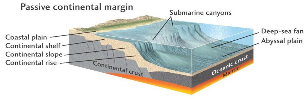
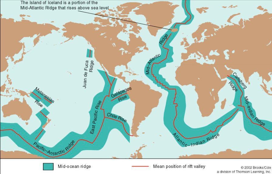
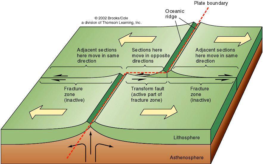
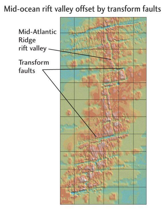
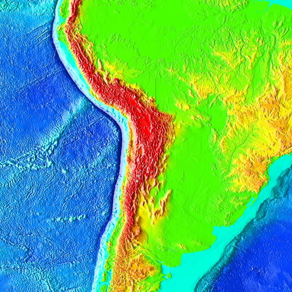
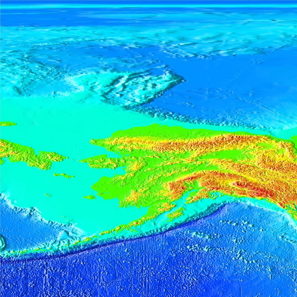
2 Basic concepts in Chapter 4 Bathymetry the measurement of water depths and mapping of sea floor features uses several types of technology. The sea floor has two distinct regions: continental margins and deep ocean basins. Continental margins are the relatively shallow areas of the ocean floor near shore. Geologically they are part of the adjacent continent. Passive vs. active continental margins are distinguished by their plate tectonic setting. Major features: continental shelf, shelf break, continental slope, continental rise, submarine canyons, submarine fans. Deep-ocean basins differ from the continental margins in tectonic origin, history, and composition. Most important features of the deep ocean basins were formed by plate tectonic processes. Major features: mid-ocean ridge, transform faults & fracture zones, hydrothermal vents, abyssal plain, abyssal hills, seamounts & guyots, oceanic trench & volcanic arc.
3 Evolution of the oceans (and continents) over the last 650 million years

4
5
6
7
8

9
10
11

12

13

14
15
16

17
18

19

20

21 Present Vail Curve of Sea Level History Transgression Regression 540 million years BP
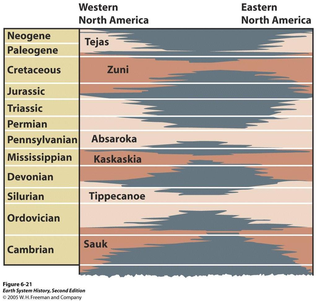
22 Blue = No deposition
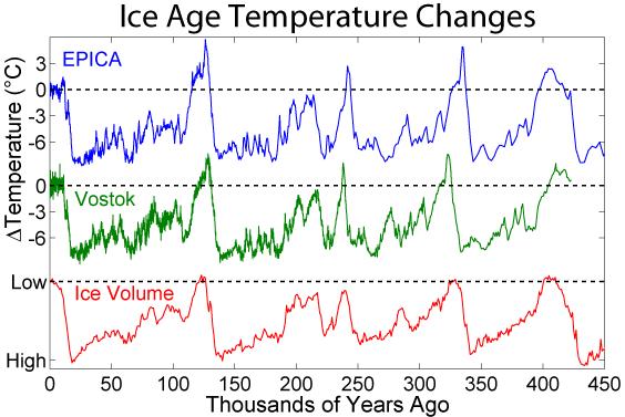
23 Interglacial Glacial
24
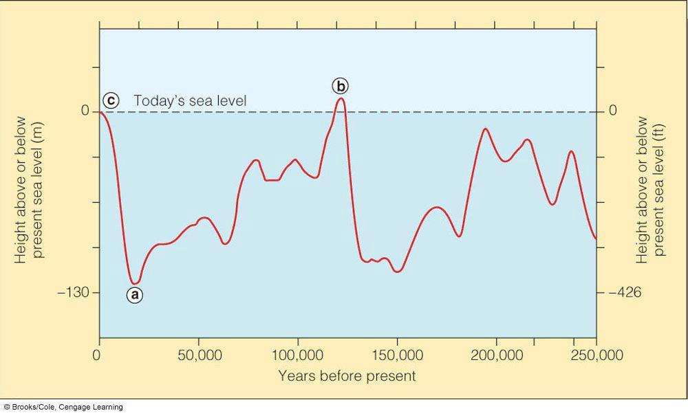
25 What about changes in sea level? glacial/interglacial timescale Increase of ~120 meters
26 What about changes in sea level? Over Figure the last 5.13 century Increase of ~15 centimeters

27 Bathymetry: Measuring Ocean Depths As late as 1870 bathymetric studies were often performed using a weighted line dropped to measure depth. Advances in Bathymetry Echo sounding (1922) Multibeam systems Satellite altimetry

28 Echo sounding is a method of measuring depth using powerful sound pulses. The time it takes for the sound pulse to travel to the sea bed and bounce back is a measure of the depth. Distance = Rate x Time

29 Trace of an echo sounder is just a line

30 Multibeam systems can provide more accurate measurements than echo sounders. Multibeam systems collect data from as many as 121 beams to measure the contours of the ocean floor.

31 Fig. 4-3b, p. 79
, p.")
32 Fig. 4-4 (a-b), p. 80

33 Satellite altimetry is an indirect way of measuring depth and detecting sea floor features pulses a second while moving 4 miles a second over head. Height accuracy to within 1 inch!
34
35

36 Size comparison of various volcanic features
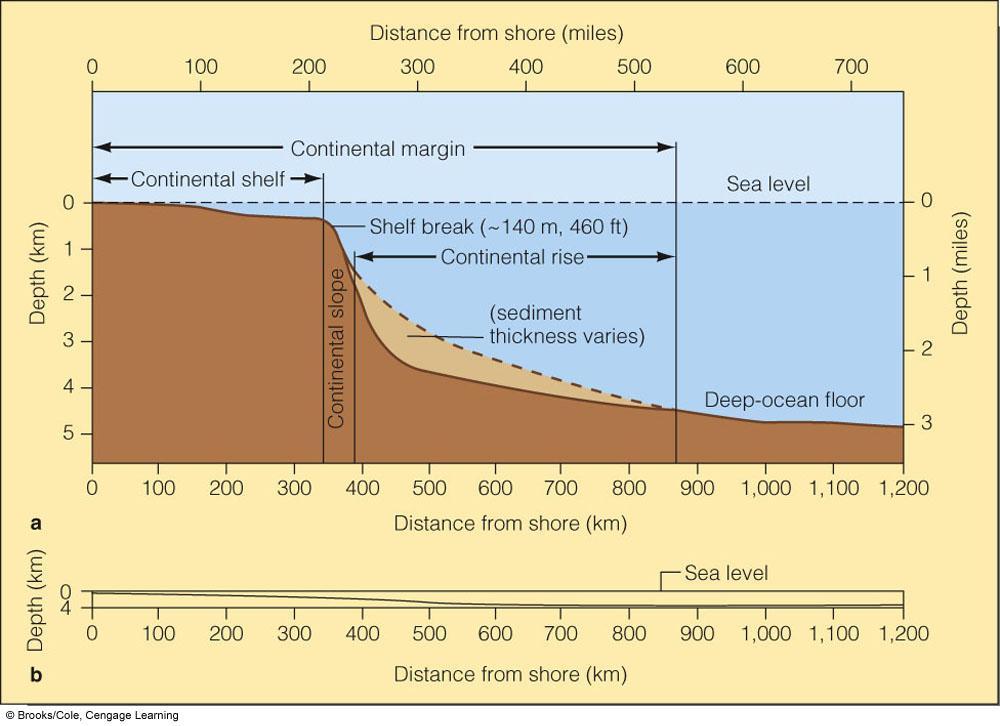
37 Continental Margins Components: 1. Continental shelf = the shallow, submerged edge of the continent 2. Shelf break = the abrupt transition from continental shelf to the continental slope 3. Continental slope = the transition between the continental shelf and the deep-ocean floor 4. Continental rise = thick accumulations of sediment found at the base of the continental slope
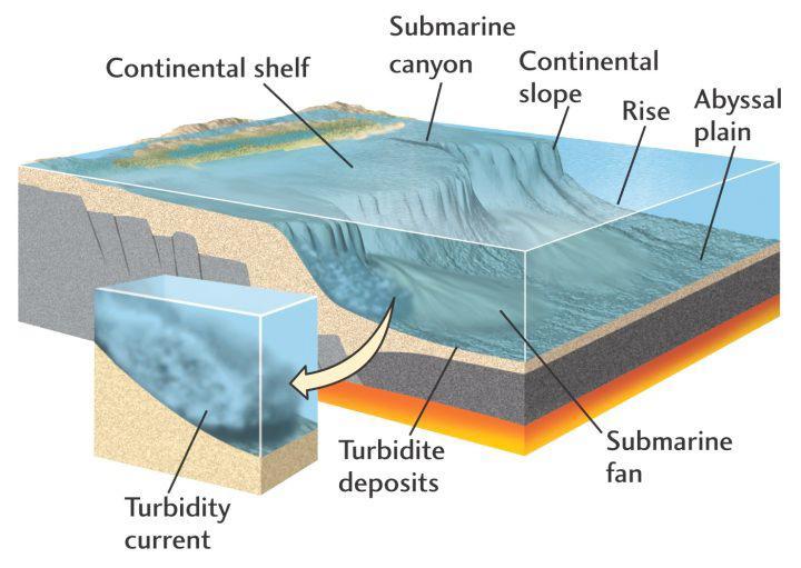
38
39

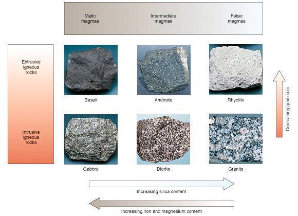
40 Continental margin = the submerged outer edge of a continent; really just an extension of the continental crust, which has an average composition of granite. vs. Deep-ocean basin = the deep sea floor beyond the continental margin; made up of oceanic crust, which is composed mostly of volcanic basalt.
 \" Located near the edges of converging plates, where one plate subducts beneath another at an oceanic trench \" Extensive volcanic and earthquake")
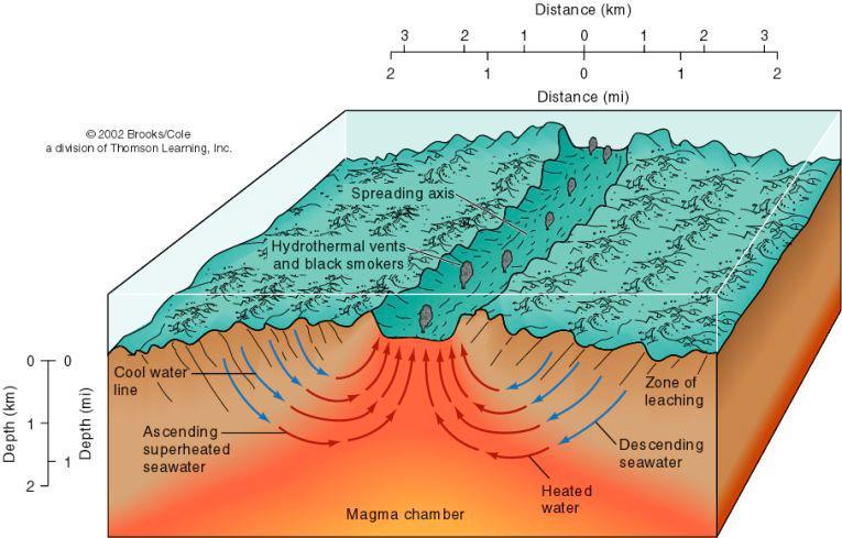
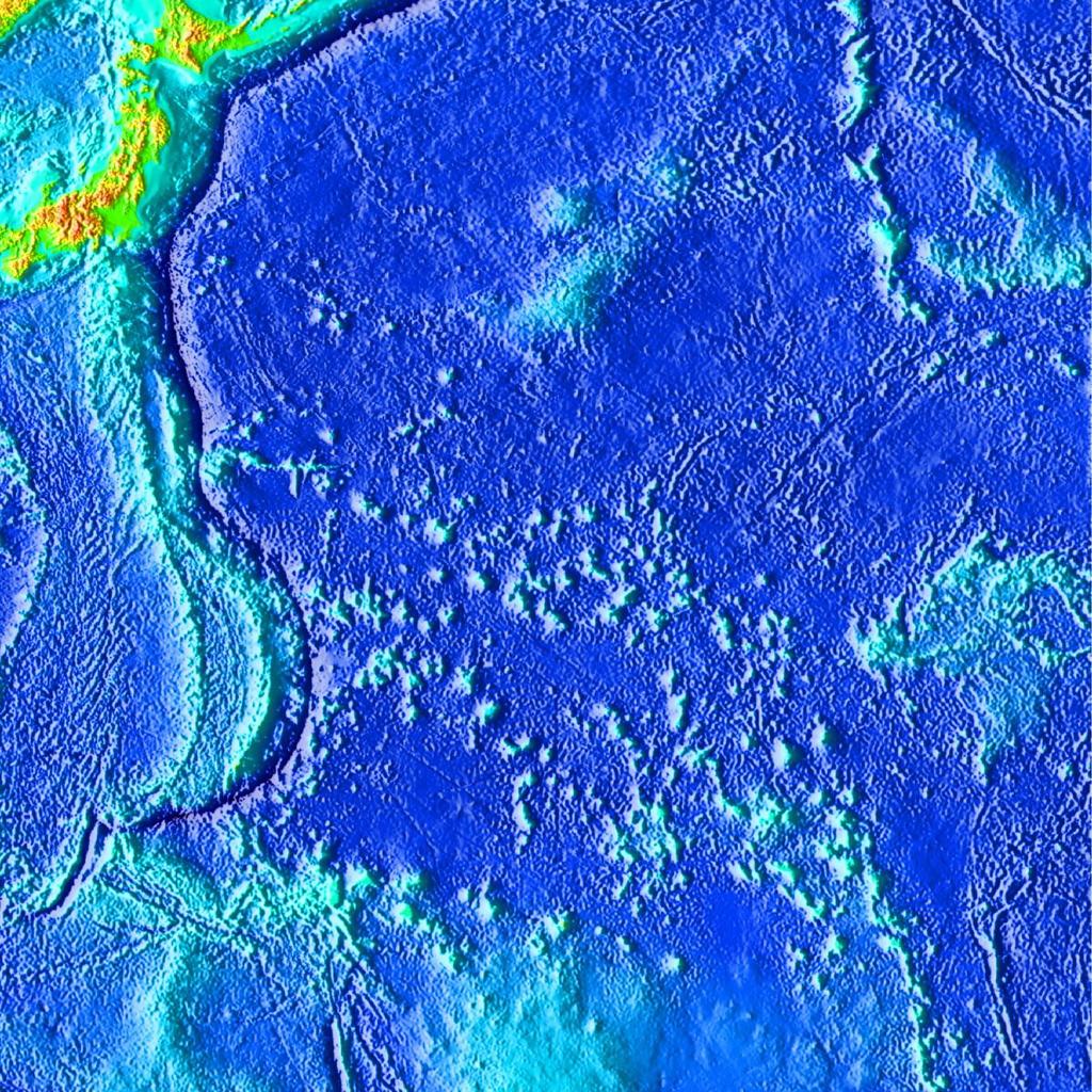
41 Types of continental margins Passive margins (= Atlantic-type margins) " They face the edges of diverging tectonic plates " Very little volcanic or earthquake activity Active margins (= Pacific-type margins) " Located near the edges of converging plates, where one plate subducts beneath another at an oceanic trench " Extensive volcanic and earthquake activity
42
43

44 Fig. 4-10, p. 85

45 Fig. 4-11, p. 86

46 Submarine Canyons Underwater landslides or avalanches called turbidity currents commonly flow down submarine canyons. The debris settles out to build up a submarine fan at the base of the canyon.

47 Continental slope Continental rise

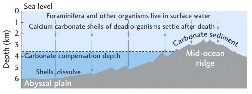
48 An underwater debris flow, i.e. a turbidite.

49 Fig. 4-14, p. 87
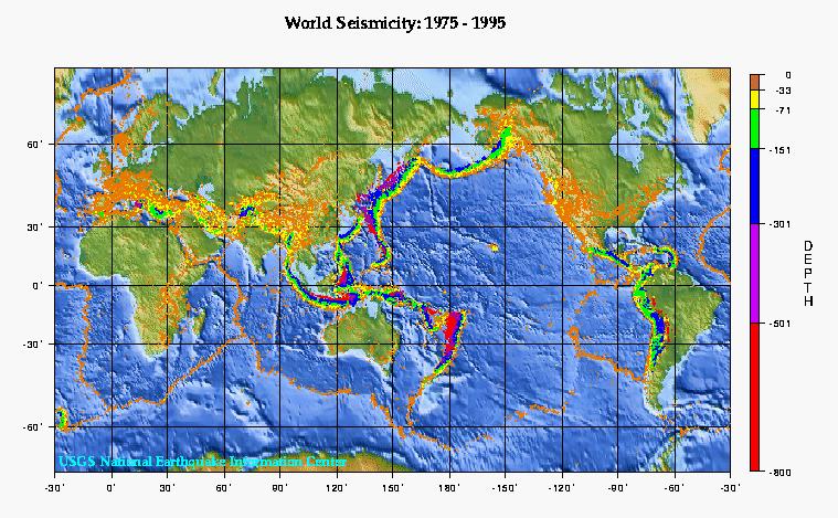
50 Deep Ocean Basins Major features: Mid-ocean ridges Fracture zones and transform faults Hydrothermal vents Shallow earthquakes Abyssal plains Abyssal hills Seamounts and guyots Oceanic trenches Volcanic arcs Deep earthquakes
51
52
53

54 Fig. 4-17a, p. 90
55

56 JuandeFucaSmoker.avi
57 Abyssal Plains Abyssal plains = broad flat areas of sediment-covered ocean floor found between the continental margins and the mid-ocean ridges Typically 4-6 km below sea level The flattest surface on Earth Sedimentation rates are very slow -- millimeters/1000 years! Mostly very fine clay, windblown dust, and shells of microscopic organisms Carbonate sediments are rare, as most of the plain is below the Carbonate Compensation Depth (CCD)

58 Thick layers of sediment on top of submerged mountains
59

60 Trenches Oceanic trenches are the deepest parts of the sea floor. They are formed by subduction. Notice that most trenches (and therefore most subduction) occur in the Pacific ocean basin.
61
62

63 Subduction at oceanic trenches causes the descending plate to generate melting of the overlying mantle, forming volcanic island arcs = lines of volcanic islands and seamounts running parallel to the edges of trenches. Subduction also causes many earthquakes.

64 Seismic activity in the Aleutian Islands
65

66 The Aleutian Island Chain

67 Formation of Guyots and submerged mountain chains Fig. 4-23a, p. 95

68 Oceanic-Oceanic Subduction Zone Oceanic-Continental Subduction Zone

69 Oceanic-Oceanic and Oceanic-Continental Subduction Zones

70 Passive Continental Margin
71
Oceanography, An Invitation to Marine Science 9e Tom Garrison. Ocean Basins Cengage Learning. All Rights Reserved.
 Oceanography, An Invitation to Marine Science 9e Tom Garrison 4 Ocean Basins Key Concepts Tectonic forces shape the seabed The ocean floor is divided into continental margins and deep ocean basins The
Map shows 3 main features of ocean floor
 Map shows 3 main features of ocean floor 2017 Pearson Education, Inc. Chapter 3 Marine Provinces 2017 Pearson Education, Inc. 1 Chapter 3 Overview The study of bathymetry determines ocean depths and ocean
Marine Science and Oceanography
 Marine Science and Oceanography Marine geology- study of the ocean floor Physical oceanography- study of waves, currents, and tides Marine biology study of nature and distribution of marine organisms Chemical
Chapter Overview. Bathymetry. Measuring Bathymetry. Measuring Bathymetry
 CHAPTER 3 Marine Provinces Chapter Overview The study of bathymetry determines ocean depths and ocean floor topography. Echo sounding and satellites are efficient bathymetric tools. Most ocean floor features
Bathymetry Measures the vertical distance from the ocean surface to mountains, valleys, plains, and other sea floor features
 1 2 3 4 5 6 7 8 9 10 11 CHAPTER 3 Marine Provinces Chapter Overview The study of bathymetry determines ocean depths and ocean floor topography. Echo sounding and satellites are efficient bathymetric tools.
Lecture Marine Provinces
 Lecture Marine Provinces Measuring bathymetry Ocean depths and topography of ocean floor Sounding Rope/wire with heavy weight Known as lead lining Echo sounding Reflection of sound signals 1925 German
MARINE GEOLOGY & GEOGRAPHY
 MARINE GEOLOGY & GEOGRAPHY Bathymetry BATHYMETRY BATHYMETRY THE UNDERWATER EQUIVALENT TO TOPOGRAPHY THE STUDY OF WATER DEPTH A BATHYMETRIC MAP SHOWS FLOOR RELIEF OR TERRAIN AS CONTOUR LINES Bathymetry
The Ocean Floor Earth Science, 13e Chapter 13
 The Ocean Floor Earth Science, 13e Chapter 13 Stanley C. Hatfield Southwestern Illinois College The vast world ocean Earth is often referred to as the blue planet Seventy-one percent of Earth s surface
Foundations of Earth Science, 6e Lutgens, Tarbuck, & Tasa
 Foundations of Earth Science, 6e Lutgens, Tarbuck, & Tasa Oceans: The Last Frontier Foundations, 6e - Chapter 9 Stan Hatfield Southwestern Illinois College The vast world ocean Earth is often referred
ARE YOU READY TO THINK? Look at the first slide THINK PAIR SHARE!
 ARE YOU READY TO THINK? Look at the first slide THINK PAIR SHARE! WHAT PROMINENT FEATURE CAN YOU IDENTIFY IN THIS PICTURE? What do you think the different colors represent? Who might find such a picture
MARINE GEOLOGY & GEOGRAPHY
 MARINE GEOLOGY MARINE GEOLOGY & GEOGRAPHY Marine Geology 4 LAYERS OF THE EARTH CRUST THICKNESS: VARIES BETWEEN OCEAN & CONTINENTS 5-40 KM STATE: SOLID ELEMENTS: SILICON, ALUMINUM, CALCIUM, SODIUM, POTASSIUM
Earth s Continents and Seafloors. GEOL100 Physical Geology Ray Rector - Instructor
 Earth s Continents and Seafloors GEOL100 Physical Geology Ray Rector - Instructor OCEAN BASINS and CONTINENTAL PLATFORMS Key Concepts I. Earth s rocky surface covered by of two types of crust Dense, thin,
14.2 Ocean Floor Features Mapping the Ocean Floor
 14.2 Ocean Floor Features Mapping the Ocean Floor The ocean floor regions are the continental margins, the ocean basin floor, and the mid-ocean ridge. 14.2 Ocean Floor Features Continental Margins A continental
Unit 6: The Sea Floor
 Unit 6: The Sea Floor Turn to Page 62 in Introduction to the World s Oceans Study the bathymetric chart What features do you see? How do the Atlantic and Pacific Oceans differ? What do you think accounts
The giant Gas planets of the outer solar system. Rocky inner planets. Silicates with Iron/Nickel cores. Hydrogen, Helium, methane, water, ammonia
 SUN Hydrogen (74%), some helium (24%) Rocky inner planets Silicates with Iron/Nickel cores The giant Gas planets of the outer solar system Hydrogen, Helium, methane, water, ammonia Where did the water
The Ocean Floor Chapter 14. Essentials of Geology, 8e. Stan Hatfield and Ken Pinzke Southwestern Illinois College
 The Ocean Floor Chapter 14 Essentials of Geology, 8e Stan Hatfield and Ken Pinzke Southwestern Illinois College The vast world ocean Earth is often referred to as the water planet 71% of Earth s surface
Earth / Environmental Science. Ch. 14 THE OCEAN FLOOR
 Earth / Environmental Science Ch. 14 THE OCEAN FLOOR The Blue Planet Nearly 70% of the Earth s surface is covered by the global ocean It was not until the 1800s that the ocean became an important focus
24. Ocean Basins p
 24. Ocean Basins p. 350-372 Background The majority of the planet is covered by ocean- about %. So the majority of the Earth s crust is. This crust is hidden from view beneath the water so it is not as
Lecture Outlines PowerPoint. Chapter 13 Earth Science 11e Tarbuck/Lutgens
 Lecture Outlines PowerPoint Chapter 13 Earth Science 11e Tarbuck/Lutgens 2006 Pearson Prentice Hall This work is protected by United States copyright laws and is provided solely for the use of instructors
Ocean Floor. Continental Margins. Divided into 3 major regions. Continental Margins. Ocean Basins. Mid-Ocean Ridges. Include:
 Ocean Floor Divided into 3 major regions Continental Margins Ocean Basins Mid-Ocean Ridges Continental Margins Include: Continental Shelves Continental Slopes Continental Rise 1 Continental Shelves Part
Chapter 2. The Planet Oceanus
 Chapter 2 The Planet Oceanus Composition of the Earth The Earth consists of a series of concentric layers or spheres which differ in chemistry and physical properties. There are two different ways to describe
Chapter 2 Plate Tectonics and the Ocean Floor
 Chapter 2 Plate Tectonics and the Ocean Floor Matching. Match the term or person with the appropriate phrase. You may use each answer once, more than once or not at all. 1. hydrothermal vents A. convergent
Full file at
 Essentials of Oceanography, 10e (Trujillo/Keller) Chapter 2 Plate Tectonics and the Ocean Floor Match the term with the appropriate phrase. You may use each answer once, more than once or not at all. A)
Divergent Boundaries: Origin and Evolution of the Ocean Floor Earth - Chapter 13 Stan Hatfield Southwestern Illinois College
 Divergent Boundaries: Origin and Evolution of the Ocean Floor Earth - Chapter 13 Stan Hatfield Southwestern Illinois College Mapping the Ocean Floor Depth was originally measured by lowering weighted lines
Divergent Boundaries: Origin and Evolution of the Ocean Floor
 1 2 3 4 5 6 7 8 9 10 11 12 Divergent Boundaries: Origin and Evolution of the Ocean Floor Earth, 12 th Edition, Chapter 13 Chapter 13 Divergent Boundaries From 1872 to 1876, the HMS Challenger expedition
I. Earth s Layers a. Crust: Earth s outside layer. Made of mostly rock. i. Continental: er; made of mostly granite, forms the continents and shallow
 I. Earth s Layers a. Crust: Earth s outside layer. Made of mostly rock. i. Continental: er; made of mostly granite, forms the continents and shallow sea beds, floats! ii. Oceanic: er; dense rock such as
Origin and Evolution of the Ocean Floor
 Origin and Evolution of the Ocean Floor Outline Mapping the Ocean Floor Continental Margins Origin of Oceanic Lithosphere Structure of Ocean Crust Mapping the ocean floor Depth originally measured by lowering
Oceanography is the scientific study of oceans Oceans make up over 70% of the Earth s surface
 Oceanography Oceanography is the scientific study of oceans Oceans make up over 70% of the Earth s surface An ocean must be large and have features which set it apart from other oceans (currents, water
Origin and Evolution of the Ocean Floor
 Chapter 13 Lecture Earth: An Introduction to Physical Geology Twelfth Edition Origin and Evolution of the Ocean Floor Tarbuck and Lutgens Chapter 13 Divergent Boundaries An Emerging Picture of the Ocean
Chapter 9 Lecture Outline. Oceans: The Last Frontier
 Chapter 9 Lecture Outline Oceans: The Last Frontier The Vast World Ocean Earth is referred to as the blue planet 71% of Earth s surface is oceans and marginal seas Continents and islands comprise the remaining
Small area of the ocean that is partially surrounded by land. The Ocean Basins. Three Major Oceans. Three Major Oceans. What is a SEA?
 The Ocean Basins How Deep is the Ocean? 1 2 Three Major Oceans Three Major Oceans Pacific Atlantic the shallowest ocean (3.3km average depth) Indian second shallowest ocean (3.8km average depth) Pacific
Shape of the seafloor. Shape of the seafloor. Shape of the seafloor. Shape of the seafloor. Shape of the seafloor. Shape of the seafloor
 Multibeam echo sounders - Research vessel Scripps Institution of Oceanography R/V Roger Revelle depth Source: Scripps Institution of Oceanography http://woodshole.er.usgs.gov/project-pages/caribbean/movie1.html
Seas. A sea is a part of an ocean that is nearly surrounded by water. The Mediterranean, Arctic and Black Sea are really part of the Atlantic Ocean.
 Exploring the Ocean Since ancient times people have studied the ocean such as waters and ocean floor It provides food and services, and serves as a route for trade and travel The World s Oceans 71% of
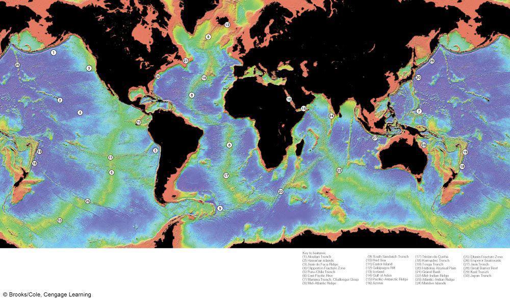
The Major Ocean Basins and Their Features
 Where Submarines Lurk Recent satellite studies and deep-sea mapping programs have revealed in dramatic fashion that the ocean floor is not flat. Indeed, the terrain of the ocean floor surpasses that of
MULTIPLE CHOICE. Choose the one alternative that best completes the statement or answers the question.
 Geology 300, Physical Geology Spring 2019 Quiz Chapter 18, Seafloor Name MULTIPLE CHOICE. Choose the one alternative that best completes the statement or answers the question. 1) Abyssal fans are made
The Sea Floor. Chapter 2
 The Sea Floor Chapter 2 Geography of the Ocean Basins World ocean is the predominant feature on the Earth in total area Northern Hemisphere = 61% of the total area is ocean. Southern Hemisphere = about
Earth s Seafloors. Ocean Basins and Continental Margins. Introductory Oceanography Ray Rector - Instructor
 Earth s Seafloors Ocean Basins and Continental Margins Introductory Oceanography Ray Rector - Instructor OCEAN BASINS and CONTINENTAL PLATFORMS Key Concepts I. Earth s rocky surface covered by of two types
Essential Question: How are the geological features that exist on land similar to the geological features on the ocean floor?
 Essential Question: How are the geological features that exist on land similar to the geological features on the ocean floor? Geography of the Oceans The world ocean can be divided into four main ocean
Plate Tectonics: A Unifying Theory
 Plate Tectonics: A Unifying Theory What is Plate Tectonics? - 7 large tectonic plates and many smaller ones that break up the lithosphere - Plates are brittle and float on asthenosphere and glide past
The Marine Environment
 The Marine Environment SECTION 16.1 Shoreline Features In your textbook, read about erosional landforms, beaches, estuaries, longshore currents, and rip currents. For each statement below, write or. 1.
Unit 4 - Water. Earth s Interior. Earth s Interior. Continental Drift. Continental Drift. Continental Drift. Crust. Mantle. Core.
 Unit 4 - Water How did the oceans form? What special adaptations do saltwater organisms have? Where does our water come from? How do humans affect the Earth s water? Crust Rigid outer shell of Earth Oceanic
Geography of the world s oceans and major current systems. Lecture 2
 Geography of the world s oceans and major current systems Lecture 2 WHY is the GEOMORPHOLOGY OF THE OCEAN FLOOR important? (in the context of Oceanography) WHY is the GEOMORPHOLOGY OF THE OCEAN FLOOR important?
Seafloor Morphology. Techniques of Investigation. Bathymetry and Sediment Studies
 Seafloor Morphology I f we select a grid for the surface of the earth (i.e. 5 km 2 ) and assign it an average elevation in relation to sea level, we can construct a graph of elevation versus area of the
Chapter 02 The Sea Floor
 Chapter 02 The Sea Floor Multiple Choice Questions 1. One of the following is not one of the world's major ocean basins: A. Atlantic Ocean B. Arctic Ocean C. Indian Ocean D. Antarctic Ocean E. Pacific
Lecture 26: Marine Geology Read: Chapter 21 Homework due December 3
 Learning Objectives (LO) Lecture 26: Marine Geology Read: Chapter 21 Homework due December 3 What we ll learn today:! 1. Describe the world s five oceans! 2. Understand patterns of ocean circulation! 3.
1. Name at least one place that the mid-atlantic Ridge is exposed above sea level.
 Interpreting Tectonic and Bathymetric Maps. The purpose of this lab is to provide experience interpreting the bathymetry of the seafloor in terms of tectonic and geologic settings and processes. Use the
Plate Tectonics: The New Paradigm
 Earth s major plates Plate Tectonics: The New Paradigm Associated with Earth's strong, rigid outer layer: Known as the lithosphere Consists of uppermost mantle and overlying crust Overlies a weaker region
1. Define habitat and describe how geologic processes influence habitats. Habitats 2. How much of the earth s surface is covered by sea water?
 1. Define habitat and describe how geologic processes influence habitats. Habitats are the natural environments in which organisms live. They are directly shaped by geological processes, which influence
Lecture 05: Ocean Basins. Hypsometric Curve. Consider Ocean Basins: What is the elevation of Chambana?
 Lecture 05: Ocean Basins 1 Hypsometric Curve What is the elevation of Chambana? Shows distribution of surface relative to sea level ~67% below sea level Mean ocean depth ~ -3.7 km (well below sea level)
Marine Geosciences / Oceanography Fields and disciplines
 Marine Geosciences / Oceanography Fields and disciplines Marine Geosciences; Oceanography Chemical Oceanography Marine chemistry; marine geochemistry Biological Oceanography Marine biology; marine biogeochemistry
OCN 201 Physiography of the Seafloor
 OCN 201 Physiography of the Seafloor Hypsometric Curve for Earth s solid surface Note histogram Hypsometric curve of Earth shows two modes. Hypsometric curve of Venus shows only one! Why? Ocean Depth vs.
MAR110 Lecture #3 Ocean Bathymetry / Plate Tectonics
 1 MAR110 Lecture #3 Ocean Bathymetry / Plate Tectonics Ocean Basin Geographic Zones The geographic zones of the North Atlantic are identified in the bird s eye view of the sea floor above. Below is shown
OCN 201 Physiography of the Seafloor
 OCN 201 Physiography of the Seafloor 1 Ocean Depth versus Continental Height Why do we have dry land? Solid surface of Earth is dominated by two levels: Land with a mean elevation of +840 m (29% of Earth
Earth s Structure and Surface
 Earth s Structure and Surface Structure of the Earth The earth is thought have originated about 4.5 billion years ago from a cloud or clouds of dust. The dust was the remains of a huge cosmic explosion
Oceanography. Oceanography is the study of the deep sea and shallow coastal oceans.
 Oceanography Oceanography is the study of the deep sea and shallow coastal oceans. Studying the Ocean Floor To determine the shape and composition of the ocean floor, scientists use techniques such as
CHAPTER 3 Ocean Basins
 Review: What Drives Plate Motions: (1) Density vs. Gravity: causes oceanic crust to sink in subduction zones, causes crust to extend at spreading ridges (called ridge push, but the ridge is not pushing,
OCEANOGRAPHY MEASURING THE DEPTHS OF THE OCEANS
 Water 2 page 1 OCEANOGRAPHY Name If all the water was drained from the ocean basins, what kind of surface would be revealed? It would not be the quiet, subdued topography as was once thought, but a surface
Objectives: Describe the structure of the ocean floor. Describe light intensity and temperature characteristics at different ocean depths.
 Ocean Structure Virtual Lab What are some characteristics of the ocean and the ocean floor? Earths highest mountains, deepest valleys, and flattest plains are found not on land but under the ocean. Beyond
Isostasy, Bathymetry and the Physiography of the Ocean Floor
 Isostasy, Bathymetry and the Physiography of the Ocean Floor EPSS 15 Spring 2017 Ad art for NBC Radio, 1939 Archimedes (c. 287 BCE 212 BCE) Greek mathematician, physicist and engineer Archimedes Principle:
Questions and Topics
 Plate Tectonics and Continental Drift Questions and Topics 1. What are the theories of Plate Tectonics and Continental Drift? 2. What is the evidence that Continents move? 3. What are the forces that
The Lithosphere and the Tectonic System. The Structure of the Earth. Temperature 3000º ºC. Mantle
 The Lithosphere and the Tectonic System Objectives: Understand the structure of the planet Earth Review the geologic timescale as a point of reference for the history of the Earth Examine the major relief
60% water. Big Bang: 14,000 millions years ago The Earth originated about 4,500 millions years ago its orbit allows water to exist in a liquid state!
 Ch2. The Sea Floor #1 Why geology of the oceans? Marine habitats are directly shaped by geological processes The form of the coastlines The depth of the water Type of bottom (muddy, sandy, rocky) #2 Geological
Chapter Two. Figure 02_02. Geography of the Ocean Basins. The Sea Floor
 Chapter Two The Sea Floor Geography of the Ocean Basins Figure 02_02 The world ocean is the predominant feature on the Earth in total area. In the Northern Hemisphere, 61% of the total area is ocean. In
GENERAL GEOLOGY Fall Chapter 18: The Sea Floor. Partial Examination IV Study Guide Dr. Glen S. Mattioli
 GENERAL GEOLOGY 1113-005 Fall 2008 Partial Examination IV Study Guide Dr. Glen S. Mattioli Note that these are NOT questions, but rather are a list of topics that we have covered either in class or are
The Marine Environment
 The Marine Environment SECTION 16.1 Shoreline Features In your textbook, read about erosional landforms, beaches, estuaries, longshore currents, and rip currents. For each statement below, write true or
Test on Chapters 7-11 Monday, April 28, 2014 No Calculator Required
 Test on Chapters 7-11 Monday, April 28, 2014 No Calculator Required Chapter Sections: Oceans: 7.1 7.2 7.4 Bathymetry: 8.3 Earth s Interior: 10.1 10.2 10.3 Plate Tectonics: 11.1 11.2 11.3 Study/Review:
Plate Tectonics. A. Continental Drift Theory 1. Early development 2. Alfred Wegener s mechanism
 Plate Tectonics A. Continental Drift Theory 1. Early development 2. Alfred Wegener s mechanism B. Seafloor Spreading 1. Earthquakes and volcanoes 2. Seafloor maps and dates 3. Continental drift revisited
The Four Layers The Earth is composed of four different layers. The crust is the layer that you live on, and it is the most widely studied and
 Earth s Structure The Four Layers The Earth is composed of four different layers. The crust is the layer that you live on, and it is the most widely studied and understood. The mantle is much hotter and
OCEANOGRAPHY II NOTES
 TIDES OCEANOGRAPHY II NOTES MRS. BURKEY EARTH SPACE SCIENCE CY CREEK HS THE RISE AND FALL IN SEA LEVEL IS CALLED A TIDE. CAUSED BY A GIANT WAVE. AVERAGE LOW-TIDE/HIGH-TIDE CYCLE TAKES ABOUT 12 HRS AND
Plate Tectonics 3. Where Does All the Extra Crust Go?
 Plate Tectonics 3 Where Does All the Extra Crust Go? Unless otherwise noted the artwork and photographs in this slide show are original and by Burt Carter. Permission is granted to use them for non-commercial,
Ocean Scavenger Hunt. Materials: pencil study notes timer. Directions:
 Ocean Scavenger Hunt Materials: pencil study notes timer Directions: 1. Each student receives a copy of the scavenger hunt, placed upside down on their desk. 2. Explain to students that they will scavenge
Plate Tectonics. entirely rock both and rock
 Plate Tectonics I. Tectonics A. Tectonic Forces are forces generated from within Earth causing rock to become. B. 1. The study of the origin and arrangement of Earth surface including mountain belts, continents,
Directed Reading. Section: The Water Planet. surface is called the a. Earth s ocean. b. Pacific Ocean. c. salt-water ocean. d. global ocean.
 Skills Worksheet Directed Reading Section: The Water Planet 1. The body of salt water covering nearly three-quarters of the Earth s surface is called the a. Earth s ocean. b. Pacific Ocean. c. salt-water
Chapter 2 Plate Tectonics and the Ocean Floor
 Chapter 2 Plate Tectonics and the Ocean Floor Chapter Overview Much evidence supports plate tectonics theory. The plate tectonics model describes features and processes on Earth. Plate tectonic science
In 1990, 50% of the U.S. population lived within 75 km of a coast. By 2010, 75% of the U.S. population will live within 75 km of a coast.
 In 1990, 50% of the U.S. population lived within 75 km of a coast. By 2010, 75% of the U.S. population will live within 75 km of a coast. High Tech Methods for Surveying the Deep Sea Floor Fig. 20.18 1
Do Now: Vocabulary: Objectives. Vocabulary: 1/5/2016. Wegener? (Can they move?) the idea that continents have moved over time?
 the idea that continents have moved over time?") Do Now: 1. Who was Alfred Wegener? 2. What was Pangaea? 3. Are continents fixed? (Can they move?) 4. What evidence supports the idea that continents have moved over time? Objectives What evidence suggests
Do Now: 1. Who was Alfred Wegener? 2. What was Pangaea? 3. Are continents fixed? (Can they move?) 4. What evidence supports the idea that continents have moved over time? Objectives What evidence suggests
1.4 Notes: Plates Converge or Scrape Past Each Other Think About Tectonic Plates Push Together at Convergent Boundaries
 1.4 Notes: Plates Converge or Scrape Past Each Other Think About If new crust is created at divergent boundaries, why does the total amount of crust on Earth stay the same? Tectonic Plates Push Together
3. PLATE TECTONICS LAST NAME (ALL IN CAPS): FIRST NAME: PLATES
: FIRST NAME: PLATES") LAST NAME (ALL IN CAPS): FIRST NAME: PLATES 3. PLATE TECTONICS The outer layers of the Earth are divided into the lithosphere and asthenosphere. The division is based on differences in mechanical properties
LAST NAME (ALL IN CAPS): FIRST NAME: PLATES 3. PLATE TECTONICS The outer layers of the Earth are divided into the lithosphere and asthenosphere. The division is based on differences in mechanical properties
Oceanography II Notes
 Oceanography II Notes Tides The rise and fall in sea level is called a tide. Caused by a giant wave and the gravitational pull of the moon and sun on the ocean One low-tide/high-tide cycle takes about
Plate Boundaries. Presented by Kesler Science
 Presented by Kesler Science Essential Questions: 1. What is plate tectonics? 2. What are the three types of plate boundaries? 3. What crustal features are formed at plate boundaries? Quick Action INB Template
Chapter 5 Notes: Plate Tectonics
 Chapter 5 Notes: Plate Tectonics Earth s Interior Scientists learn about the interior of Earth in 2 ways o Direct Method Rock Samples Drilling Caves o Indirect Method Seismic Waves Speed of waves and paths
1. I can describe evidence for continental drift theory (e.g., fossil evidence, mountain belts, paleoglaciation)
") Science 10 Review Earth Science Vocabulary asthenosphere continental drift theory converging plates diverging plates earthquakes epicentre fault hot spot inner core lithosphere mantle mantle convection
Science 10 Review Earth Science Vocabulary asthenosphere continental drift theory converging plates diverging plates earthquakes epicentre fault hot spot inner core lithosphere mantle mantle convection
sonar seismic wave basalt granite
 geologist sonar crust geology seismic wave mantle constructive force basalt inner core destructive force granite outer core The solid, rocky, surface layer of the earth. an instrument that can find objects
Marine Sediments. Introductory Oceanography. Ray Rector: Instructor
 Marine Sediments Introductory Oceanography Ray Rector: Instructor Ocean Basins are Vast Sinks for Huge Amounts of Sediment from Numerous Different Sources Four Major Types of Seafloor Sediments 1. Lithogenous
USU 1360 TECTONICS / PROCESSES
 USU 1360 TECTONICS / PROCESSES Observe the world map and each enlargement Pacific Northwest Tibet South America Japan 03.00.a1 South Atlantic Arabian Peninsula Observe features near the Pacific Northwest
Sea-Floor Spreading, Subduction,& Plate Boundaries. Lecture Continental Fit 2. Similar Rocks, Ages 3. Similar Fossils 4. Widespread Glaciation
 Sea-Floor Spreading, Subduction,& Plate Boundaries Lecture 21 Prop: Test 3 Invitations Alfred Wegener s Evidence for Continental Drift 1. Continental Fit 2. Similar Rocks, Ages 3. Similar Fossils 4. Widespread
ANOTHER MEXICAN EARTHQUAKE! Magnitude 7.1, Tuesday Sept. 19, 2017
 ANOTHER MEXICAN EARTHQUAKE! Magnitude 7.1, Tuesday Sept. 19, 2017 Why is there no oceanic crust older than 200 million years? SUBDUCTION If new oceanic crust is being continuously created along the earth
EPSS 15 Introduction to Oceanography Spring Physiography of the Ocean Basins
 EPSS 15 Introduction to Oceanography Spring 2017 Physiography of the Ocean Basins ISOSTASY The surface of the earth can be subdivided into two major areas: 1) the ocean basins and 2) the continents. Although
Tsunami, earthquakes and volcanic eruptions. Tsunami, earthquakes and volcanic eruptions. Destruction of Moawhitu. Plate tectonics: terminology
 Tsunami, earthquakes and volcanic eruptions Tsunami, earthquakes and volcanic eruptions Tsunami: Wavelenths > 200 km Very fast in open ocean Destruction of Moawhitu Brian Flintoff, New Zealand Plate tectonics
Plate Tectonics. Earth has distinctive layers - Like an onion
 Plate Tectonics Earth has distinctive layers - Like an onion Earth s Interior Core: Metallic (Iron, Nickel) Inner (hot, solid, dense, Iron, Nickel) Outer (cooler, liquid, less dense) Crust (outermost layer):
Lab 1: Plate Tectonics April 2, 2009
 Name: Lab 1: Plate Tectonics April 2, 2009 Objective: Students will be introduced to the theory of plate tectonics and different styles of plate margins and interactions. Introduction The planet can be
UNIT 3 GEOLOGY VOCABULARY FLASHCARDS THESE KEY VOCABULARY WORDS AND PHRASES APPEAR ON THE UNIT 3 CBA
 UNIT 3 GEOLOGY VOCABULARY FLASHCARDS THESE KEY VOCABULARY WORDS AND PHRASES APPEAR ON THE UNIT 3 CBA A map that shows Earth s Topographic Map surface topography, which is Earth s shape and features Contour
Dynamic Crust Practice
 1. Base your answer to the following question on the cross section below and on your knowledge of Earth science. The cross section represents the distance and age of ocean-floor bedrock found on both sides
Geologic Evolution of Latin America. Plate Tectonics: General Concepts & Applications to Latin America
 Geologic Evolution of Latin America Plate Tectonics: General Concepts & Applications to Latin America Structure of Earth: 3 major divisions of Core, Mantle, and Crust Upper mantle differs in the way that
Plate Tectonics. Structure of the Earth
 Plate Tectonics Structure of the Earth The Earth can be considered as being made up of a series of concentric spheres, each made up of materials that differ in terms of composition and mechanical properties.
The Sea Floor and Its Sediments OCEA 101
 The Sea Floor and Its Sediments OCEA 101 Measuring the depth of the ocean 85BC Posidonius measured depth of Med using rope and rock as ~2000m. Same idea used for next 2000 yrs using graduated ropes and
Chapter 14: The Ocean Floor
 Chapter 14: The Ocean Floor Section 1: The Vast World Ocean I. The Blue Planet Group # II. Geography of the Oceans Group # III. Mapping the Ocean Floor Group # A. Sonar Group # B. Satellites Group # C.
Exploring Inside the Earth
 Plate Tectonics Exploring Inside the Earth Geologists have used evidence from rock samples and evidence from seismic waves to learn about Earth s interior. Geologists are scientists who study the forces
Alfred Wegener gave us Continental Drift. Fifty years later...
 CHAPTER 2 Plate Tectonics and the Ocean Floor Plate Tectonics: summary in haiku form Alfred Wegener gave us Continental Drift. Fifty years later... Words Chapter Overview Much evidence supports plate tectonics
12/3/2014. Plate Tectonics: A Scientific Revolution Unfolds Earth Science, 13e Chapter 7. Continental drift: an idea before its time
 Plate Tectonics: A Scientific Revolution Unfolds Earth Science, 13e Chapter 7 Stanley C. Hatfield Southwestern Illinois College Continental drift: an idea before its time Alfred Wegener First proposed