SESSION 9: CLIMATE AND WEATHER, FLUVIAL PROCESSES AND MAPWORK
|
|
|
- Helen Newman
- 5 years ago
- Views:
Transcription

1 SESSION 9: CLIMATE AND WEATHER, FLUVIAL PROCESSES AND MAPWORK KEY CONCEPTS: In this session we will: Integrate theory and mapwork. Look specifically at how climate and weather and fluvial processes can be tested in mapwork. Learner Notes: Climate and weather and fluvial processes can be tested in mapwork. When studying theory learners need to incorporate the relevant map work sections at the same time and not study them separately. A proper knowledge of theory is needed when answering these sections in mapwork. This is the reason why both papers are written on one day. X-PLANATION: CLIMATE AND WEATHER AND MAPWORK Learner Notes: The climate and weather sections indicated below are generally tested in mapwork. VALLEY CLIMATES: Mountain and Valley Winds Anabatic Winds: Brought to you by Page 1

2 Katabatic Winds: ASPECT OF SLOPE: OCEAN CURRENTS: Brought to you by Page 2


3 LAND AND SEA BREEZES: Land Breeze: Sea Breeze: HEAT ISLANDS: Brought to you by Page 3

4 FLUVIAL PROCESSES AND LANDFORMS AND MAPWORK PROFILES Longitudinal profile graded and ungraded. Brought to you by Page 4

5 Cross Profile: - Matching cross profiles with the different stages of a river - Different temporary base levels - Rejuvenation STREAM PATTERNS: - Meander - Ox Bow Lake - Braided Streams - Delta Brought to you by Page 5

6 DRAINAGE DENSITY: Diagrams showing density: Brought to you by Page 6
![Calculation of Drainage Density of a Drainage Basin: It is the total length of streams per unit area of a drainage basin Formula: Total length of the streams in the basin [km] Total area of the](/docs-images/82/86053771/images/7-1.jpg "drainage basin [km²] PERENNIAL AND NON PERENNIAL STREAMS Perennial streams flow throughout the year. When looking at the map you won t find many dams and more vegetation.")
7 Calculation of Drainage Density of a Drainage Basin: It is the total length of streams per unit area of a drainage basin Formula: Total length of the streams in the basin [km] Total area of the drainage basin [km²] PERENNIAL AND NON PERENNIAL STREAMS Perennial streams flow throughout the year. When looking at the map you won t find many dams and more vegetation. It is represented by solid blue lines Non perennial streams flow during the rainy season. They are generally associated with seasonal rainfall. You will see more dams, reservoirs and windmills. It is represented by broken blue lines Brought to you by Page 7


8 DIRECTION OF RIVER FLOW When working out the direction of river flow we look at the direction in which the gradient is decreasing. We consider the following: 1. Contour lines 2. Spot heights 3. Trigonometrical beacons 4. The direction in which the river is entering a dam or leaving the dam wall 5. The V shape created by the tributaries and main stream point to the direction to which the river is flowing Brought to you by Page 8
9 DRAINAGE PATTERNS: Brought to you by Page 9
10 Brought to you by Page 10

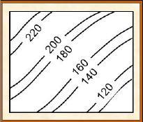
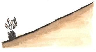
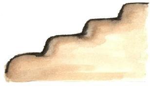
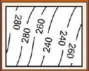
11 CONTOUR LINES AND ASSOCIATED FEATURES/LANDFORMS GENTLE SLOPE STEEP SLOPE UNIFORM SLOPE TERRACED SLOPE Brought to you by Page 11


12 CONCAVE SLOPE CONVEX SLOPE Contour Sketch and Profiles: Brought to you by Page 12
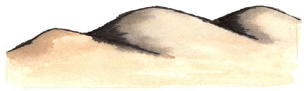
13 UNDULATING LANDSCAPE BUTTE Brought to you by Page 13


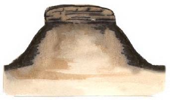
14 MESA / TAFELBERG VALLEY / SPUR Brought to you by Page 14


15 POORT / GAP Brought to you by Page 15


16 ESCARPMENT: SCARP AND DIP SLOPE: Brought to you by Page 16


17 CLIFF: Waterfall: Brought to you by Page 17


18 GORGE: WATERSHED: Brought to you by Page 18

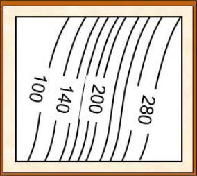
19 X-AMPLE QUESTIONS: Question 1: Map of Rustenburg West: Z 1.1 Is area Z a valley or a spur? Give a reason for your answer. 1.2 With the aid of a diagram state and explain the type of wind that this area will experience at night. 1.3 With the aid of a diagram state and explain the type of wind that this area will experience during the day. Question 2: Map of Rustenburg West: G F 2.1 Explain the concept aspect of slope. Brought to you by Page 19

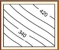
20 Question 3: J K 3.1 Explain the concept heat island. Question 4: Map of Humansdorp: M 4.1 Name the ocean current found in this area. 4.2 State the effect that this ocean current will have on the temperature and precipitation of area M. 4.3 State the type of breezes area M will experience during the day and night. Brought to you by Page 20


21 Question 5: Refer to the map extracts. Map of Rustenburg West: P 5.1 At what stage of a river is the river P in D2? 5.2 Draw and describe the cross profile that would be associated with this stage. 5.3 State the stream patterns/temporary base levels that are associated with this stage. Question 6: Map of Rustenburg West: 6.1. Explain the concept rejuvenation of a river Is rejuvenation occurring in J10? Give evidence from the map Is the longitudinal profile of the river graded or ungraded? Give a reason for your answer. Brought to you by Page 21

22 Question 7: Map of Humansdorp: Q 7.1 At what stage is the river? 7.2 Draw and describe the cross profile that would be associated with this stage. 7,3 Name and explain stream pattern Q in I4 7.4 State two other stream patterns that are associated with this stage. Question 8: Calculate the drainage density, using the following information Total length of the streams in the basin = 200km Area of basin 20cm 10cm Scale 1cm: 50000cm Brought to you by Page 22

23 Question 9: Selons River River 9.1 Differentiate between the Selons River (K1) and the river in Block K State the water table/s that the Selons River and the river in Block K4 intersect. Brought to you by Page 23

24 Question 10: River 10.1 State the direction of the river running through Doornlaagte and give a reason for your answer. Question 11: River Pattern 11.1 Identify the Drainage pattern in Blocks C7/8. Give a reason for your answer Brought to you by Page 24

 12.")
25 Question 12: 12.1 Identify the feature marked E on the topographical map. P Q Is Block D3 associated with inclined or horizontal rock strata 12.3 Identify and describe P and Q (D3) 12.4 Locate the Rustenburg Hiking Trail in blocks J 7/8: Brought to you by Page 25

26 You are a novice hiker, who is very unfit. You are given a choice between doing hiking trail C or D starting at F in J8. Which hiking trail would you choose? Give ONE reason for your answer Identify the landform at F from where you will start your hike Draw a rough cross-section from to D. Show all slope elements (6) Brought to you by Page 26
27 X-ERCISE QUESTIONS Question 1: Map of Rustenburg West: G F Using aspect of slope explain why there is farming taking place at G and not at F Question 2: J K 2.1 Which area J or K will experience Higher temperatures? Give four reasons for your answer. Brought to you by Page 27
28 SOLUTIONS TO X-ERCISE QUESTIONS Question 1: G is on the north facing slope and in the southern hemisphere the north facing slope receives more sunlight. Question 2: K K is an urban area It has more artificial surfaces, such as concrete, steel and tar. It has artificial sources of heat e.g. industrial heating It has far more polluted air which trap the heat. It has far less vegetation. (Accept other) Brought to you by Page 28
SESSION 6: FLUVIAL LANDFORMS
 SESSION 6: FLUVIAL LANDFORMS KEY CONCEPTS: Fluvial Landforms Management of River Catchment Areas Slope Elements X-PLANATION: FLUVIAL LANDFORMS Rivers form landforms as they erode the landscape. These landforms
REVISION: MAPWORK 18 SEPTEMBER 2014
 REVISION: MAPWORK 18 SEPTEMBER 2014 Lesson Description In this lesson we revise: Various mapwork calculations Summary Relative Position Bearing is the angular (angle) distance between two points True Bearing
Science EOG Review: Landforms
 Mathematician Science EOG Review: Landforms Vocabulary Definition Term canyon deep, large, V- shaped valley formed by a river over millions of years of erosion; sometimes called gorges (example: Linville
NCM COMPUTER & BUSINESS ACADEMY ASSIGNMENT TERM
 NCM COMPUTER & BUSINESS ACADEMY SUBJECT: GEOGRAPHY GRADE 12 ASSIGNMENT TERM 1-2016 TOTAL: 150 MARKS LECTURER: ANSWER ALL QUESTIONS CLIMATE, WEATHER AND GEOMORPHOLOGY Answer at least ONE question in this
Characteristics and processes associated with the development of Hilly Landscapes
 GRADE 11 GEOGRAPHY SESSION 1: GEOMORPHOLOGY I (TOPOGRAPHY) Key Concepts In this lesson we will focus on summarising what you need to know about: Topography associated with Horizontally Layered Rocks Topography
Running Water Earth - Chapter 16 Stan Hatfield Southwestern Illinois College
 Running Water Earth - Chapter 16 Stan Hatfield Southwestern Illinois College Hydrologic Cycle The hydrologic cycle is a summary of the circulation of Earth s water supply. Processes involved in the hydrologic
Streams. Stream Water Flow
 CHAPTER 14 OUTLINE Streams: Transport to the Oceans Does not contain complete lecture notes. To be used to help organize lecture notes and home/test studies. Streams Streams are the major geological agents
PHYSICAL GEOGRAPHY. By Brett Lucas
 PHYSICAL GEOGRAPHY By Brett Lucas FLUVIAL PROCESSES Fluvial Processes The Impact of Fluvial Processes on the Landscape Streams and Stream Systems Stream Channels Structural Relationships The Shaping and
MAPPING THE EARTH HOW DO YOU FIND A LOCATION ON THE EARTH?
 MAPPING THE EARTH HOW DO YOU FIND A LOCATION ON THE EARTH? UNIT TOPICS TOPIC 1: LATITUDE & LONGITUDE TOPIC 2: FIELD MAPS TOPIC 3: TOPOGRAPHIC MAPS TOPIC 4: NYS LANDSCAPES TOPIC 1: LATITUDE & LONGITUDE
mountain rivers fixed channel boundaries (bedrock banks and bed) high transport capacity low storage input output
 high transport capacity low storage input output") mountain rivers fixed channel boundaries (bedrock banks and bed) high transport capacity low storage input output strong interaction between streams & hillslopes Sediment Budgets for Mountain Rivers Little
mountain rivers fixed channel boundaries (bedrock banks and bed) high transport capacity low storage input output strong interaction between streams & hillslopes Sediment Budgets for Mountain Rivers Little
FLUVIAL PROCESSES 13 MARCH 2014
 FLUVIAL PROCESSES 13 MARCH 2014 In this lesson we: Lesson Description Look at river profiles, river grading, river rejuvenation as well as the identification, description and formation of fluvial landforms.
Why study physical features? How does it help me during the course of studying Geography Elective?
 (b) Physical features Why study physical features? How does it help me during the course of studying Geography Elective? Physical factors influence the distribution of agricultural systems. Some factors
Surface Processes Focus on Mass Wasting (Chapter 10)
") Surface Processes Focus on Mass Wasting (Chapter 10) 1. What is the distinction between weathering, mass wasting, and erosion? 2. What is the controlling force in mass wasting? What force provides resistance?
Surface Processes Focus on Mass Wasting (Chapter 10) 1. What is the distinction between weathering, mass wasting, and erosion? 2. What is the controlling force in mass wasting? What force provides resistance?
EXTERNAL LAND FORMING PROCESSES
 NAME SCHOOL INDEX NUMBER DATE EXTERNAL LAND FORMING PROCESSES WEATHERING 1 1998 Q 7 (a) (i) What is the difference between weathering and mass wasting (ii) List five processes involved in chemical weathering
ES 105 Surface Processes I. Hydrologic cycle A. Distribution % in oceans 2. >3% surface water a. +99% surface water in glaciers b.
 ES 105 Surface Processes I. Hydrologic cycle A. Distribution 1. +97% in oceans 2. >3% surface water a. +99% surface water in glaciers b. >1/3% liquid, fresh water in streams and lakes~1/10,000 of water
Surface Water and Stream Development
 Surface Water and Stream Development Surface Water The moment a raindrop falls to earth it begins its return to the sea. Once water reaches Earth s surface it may evaporate back into the atmosphere, soak
STUDY GUIDE FOR CONTENT MASTERY. Surface Water Movement
 Surface Water SECTION 9.1 Surface Water Movement In your textbook, read about surface water and the way in which it moves sediment. Complete each statement. 1. An excessive amount of water flowing downslope
Landforms. Why does the land look like it does? 1. Controlled by water 2. Controlled by the rocks
 Landforms Why does the land look like it does? 1. Controlled by water 2. Controlled by the rocks Landforms Made by Running Water Stream erosion The evolution of a river system Entrenched meanders Fluvial
Earth and Space: Topographic Maps Satellite Images
 Earth and Space: Topographic Maps Satellite Images Earth and Space: Formative Assessment Activities for Earth and Space Topographic Maps Satellite Images Teacher Pages Purpose The purpose of this station
Chapter 11. Rivers: Shaping our landscape
 Chapter 11 Rivers: Shaping our landscape Learning outcomes In this presentation you will learn: Common terms associated with rivers About the three stages of a river About the processes of river erosion
NATIONAL SENIOR CERTIFICATE GRADE 10
 NTIONL SENIOR ERTIFITE GRE 10 GEOGRPHY P2 EXEMPLR 2012 MRKS: 75 TIME: 1½ hours LERNER'S NME TOTL 15 20 25 15 75 MRK SORE MRKER MOERTOR This question paper consists of 9 pages and 1 page for rough work.
GEOL 1121 Earth Processes and Environments
 GEOL 1121 Earth Processes and Environments Wondwosen Seyoum Department of Geology University of Georgia e-mail: seyoum@uga.edu G/G Bldg., Rm. No. 122 Seyoum, 2015 Chapter 6 Streams and Flooding Seyoum,
NATIONAL SENIOR CERTIFICATE GRADE 12
 NATIONAL SENIOR CERTIFICATE GRADE 12 GEOGRAPHY P1 FEBRUARY/MARCH 2015 MARKS: 225 TIME: 3 hours This question paper consists of 12 pages and an annexure of 12 pages. *GEOGE1* Geography/P1 2 INSTRUCTIONS
Extra Credit Assignment (Chapters 4, 5, 6, and 10)
") GEOLOGY 306 Laboratory Instructor: TERRY J. BOROUGHS NAME: Extra Credit Assignment (Chapters 4, 5, 6, and 10) For this assignment you will require: a calculator and metric ruler. Chapter 4 Objectives:
GEOLOGY 306 Laboratory Instructor: TERRY J. BOROUGHS NAME: Extra Credit Assignment (Chapters 4, 5, 6, and 10) For this assignment you will require: a calculator and metric ruler. Chapter 4 Objectives:
Figure 1. Which part of the river is labelled in Figure 1? a) Mouth b) Source c) Lower course d) channel
 Mouth b) Source c) Lower course d) channel") Rivers 1. Study Figure 1 showing the long profile of a river Figure 1 A Which part of the river is labelled in Figure 1? a) Mouth b) Source c) Lower course d) channel (1 mark) 2. Complete the sentences
Rivers 1. Study Figure 1 showing the long profile of a river Figure 1 A Which part of the river is labelled in Figure 1? a) Mouth b) Source c) Lower course d) channel (1 mark) 2. Complete the sentences
Guided Notes Topographic Maps
 Guided Notes Topographic Maps Map scale Straight line distance Curved line distance Rules of Isolines Contour Lines Hachured Lines Possible elevations Slope & Gradient Direction of River Flow Topographic
Mountain Rivers. Gutta cavat lapidem. (Dripping water hollows out a stone) -Ovid, Epistulae Ex Ponto, Book 3, no. 10, 1. 5
 -Ovid, Epistulae Ex Ponto, Book 3, no. 10, 1. 5") Mountain Rivers Gutta cavat lapidem (Dripping water hollows out a stone) -Ovid, Epistulae Ex Ponto, Book 3, no. 10, 1. 5 Mountain Rivers Fixed channel boundaries (bedrock banks and bed) High transport
Mountain Rivers Gutta cavat lapidem (Dripping water hollows out a stone) -Ovid, Epistulae Ex Ponto, Book 3, no. 10, 1. 5 Mountain Rivers Fixed channel boundaries (bedrock banks and bed) High transport
Notes and Summary pages:
 Topographic Mapping 8.9C Interpret topographical maps and satellite views to identify land and erosional features and predict how these shapes may be reshaped by weathering ATL Skills: Communication taking
Year 6. Geography. Revision
 Year 6 Geography Revision November 2017 Rivers and World knowledge How the water cycle works and the meaning of the terms evaporation, condensation, precipitation, transpiration, surface run-off, groundwater
Term Knowledge Using and applying Grade Criteria Autumn 1 Assessment window October Natural hazards pose major risks to people and property.
 Assessment Schedule Year 9 2015/6 Term Knowledge Using and applying Grade Criteria Autumn 1 Assessment window October 2015 3.1.1.2 Tectonic Natural hazards pose major risks to people and property. Definition
unit 6 Review sheet 4. The photograph below shows a sandstone butte in an arid region. A. U-shaped valley B. V-shaped valley C. cliff D.
 Name: ate: 1. The large waterfall at Niagara Falls, New York, was originally located at the Niagara Escarpment. Which term best describes an escarpment? 4. The photograph below shows a sandstone butte
Erosion Surface Water. moving, transporting, and depositing sediment.
 + Erosion Surface Water moving, transporting, and depositing sediment. + Surface Water 2 Water from rainfall can hit Earth s surface and do a number of things: Slowly soak into the ground: Infiltration
Streams. Water. Hydrologic Cycle. Geol 104: Streams
 Streams Why study streams? Running water is the most important geologic agent in erosion, transportation and deposition of sediments. Water The unique physical and chemical properties of water make it
CT Science Standard 4.3 Erosion Water has a major role in shaping the earth s surface. Trail Guides
 Trail Guides We have created a set of Trail Guides for use by you and your students as you explore our galleries on your field trip. The first section consists of the trail guides with teacher notes (pages
Erosion and Deposition
 Erosion and Deposition Chapter Test A Multiple Choice Write the letter of the correct answer on the line at the left. 1. Water erosion begins when runoff from rainfall flows in a thin layer over the land
Landscape Development
 Landscape Development Slopes Dominate Natural Landscapes Created by the interplay of tectonic and igneous activity and gradation Deformation and uplift Volcanic activity Agents of gradation Mass wasting
Continental Landscapes
 Continental Landscapes Landscape influenced by tectonics, climate & differential weathering Most landforms developed within the last 2 million years System moves toward an equilibrium Continental Landscapes
GEOGRAPHY: PAPER II. 1. Write your examination number in the appropriate blocks provided above.
 NATIONAL SENIOR CERTIFICATE EXAMINATION NOVEMBER 2014 GEOGRAPHY: PAPER II EXAMINATION NUMBER Time: 1½ hours 100 marks PLEASE READ THE FOLLOWING INSTRUCTIONS CAREFULLY 1. Write your examination number in
Map reading notes. It is a very useful kind of map that shows the topography of an area, i.e whether it is flat, undulating, rugged or mountainous
 Introduction Map reading notes In the course of 2 or 3 years course, Candidates will be exposed to topographical maps from tropical countries such as Mauritius, Tanzania, Zimbabwe and Jamaica. Many of
Pre-Lab Reading Questions ES202
 ES202 The are designed to encourage students to read lab material prior to attending class during any given week. Reading the weekly lab prior to attending class will result in better grade performance
RIVERS, GROUNDWATER, AND GLACIERS
 RIVERS, GROUNDWATER, AND GLACIERS Delta A fan-shaped deposit that forms when a river flows into a quiet or large body of water, such as a lake, an ocean, or an inland sea. Alluvial Fan A sloping triangle
Ch 10 Deposition Practice Questions
 1. Base your answer to the following question on the data table below. Six identical cylinders, A through F, were filled with equal volumes of sorted spherical particles. The data table shows the particle
Fluvial Systems Lab Environmental Geology Lab Dr. Johnson
 Fluvial Systems Lab Environmental Geology Lab Dr. Johnson *Introductory sections of this lab were adapted from Pidwirny, M. (2006). "Streamflow and Fluvial Processes". Fundamentals of Physical Geography,
WATER ON AND UNDER GROUND. Objectives. The Hydrologic Cycle
 WATER ON AND UNDER GROUND Objectives Define and describe the hydrologic cycle. Identify the basic characteristics of streams. Define drainage basin. Describe how floods occur and what factors may make
Topic 1: Physical Features: Natural topography, Drainage system
 Topic 1: Physical Features: Natural topography, Drainage system 1 (a) Study Fig. 1, a physical map of Bangladesh. 2008 (i) Name the two rivers marked A and B. [2] (ii) Name the area marked C. [1] (iii)
KEY TERMS. Crevasse Glaciers Gravity Ground Water Iceberg
 10.3 SOURCES OF FRESH WATER P G. 3 7 6 OBJECTIVES Describe why run-off is important for rivers Describe how a small stream becomes a large river What is a drainage basin Describe the important and generation
What do you need for a Marathon?
 What do you need for a Marathon? Water and a snack? What about just a normal day? 1 flush = 3.5 gallons 1 flush = 3.5 gallons 10 minute shower = 20 gal 1 flush = 3.5 gallons 10 minute shower = 20 gal Jeans
SENIOR CERTIFICATE GRADE 12
 NTIONL SENIOR ERTIFITE GRE 12 GEOGRPHY P2 NOVEMER 2017 MRKS: 75 TIME: 1½ hours EXMINTION NUMER: ENTRE NUMER: Q1 Q2 Q3 Q4 TOT M In SM In M In M In IM In M E EX RM In This question paper consists of 15 pages
CAMBRIDGE INTERNATIONAL EXAMINATIONS General Certificate of Education Advanced Subsidiary Level and Advanced Level
 www.xtremepapers.com CAMBRIDGE INTERNATIONAL EXAMINATIONS General Certificate of Education Advanced Subsidiary Level and Advanced Level GEOGRAPHY 9696/01 Paper 1 Core Geography October/November 2003 Additional
MAP STUDY: INTERPRETATION OF SURVEY MAPS
 MAP STUDY: INTERPRETATION OF SURVEY MAPS Types and Elements of Maps Maps are drawn to represent the Earth on a piece of paper. Maps are used widely to represent the Earth. Maps use signs and symbols in
STREAM SYSTEMS and FLOODS
 STREAM SYSTEMS and FLOODS The Hydrologic Cycle Precipitation Evaporation Infiltration Runoff Transpiration Earth s Water and the Hydrologic Cycle The Hydrologic Cycle The Hydrologic Cycle Oceans not filling
Precipitation Evaporation Infiltration Earth s Water and the Hydrologic Cycle. Runoff Transpiration
 STREAM SYSTEMS and FLOODS The Hydrologic Cycle Precipitation Evaporation Infiltration Earth s Water and the Hydrologic Cycle Runoff Transpiration The Hydrologic Cycle The Hydrologic Cycle Oceans not filling
Running Water: The Geology of Streams and Floods Running Water Chapter 14
 Geology 800 Today Running Water: The Geology of Streams and Floods Running Water Chapter 14 Next Class Oceans and Coasts 15 Stream Flow Streams Ribbons of water that flow down channels. Runoff Water in
What are the different ways rocks can be weathered?
 Romano - 223 What are the different ways rocks can be weathered? Weathering - the breakdown of rocks and minerals at the Earth s surface 1. 2. PHYSICAL WEATHERING Rock is broken into smaller pieces with
Disciplinary Core List of Standards (NGSS) for 3-5 Earth Science Progression - 3-ESS2 Earth s Systems ESS2.D Weather and Climate -
 for 3-5 Earth Science Progression - 3-ESS2 Earth s Systems ESS2.D Weather and Climate -") Disciplinary Core List of Standards (NGSS) for 3-5 Earth Science Progression - 3-ESS2 Earth s Systems ESS2.D Weather and Climate - Scientists record patterns of the weather across different times and areas
Disciplinary Core List of Standards (NGSS) for 3-5 Earth Science Progression - 3-ESS2 Earth s Systems ESS2.D Weather and Climate - Scientists record patterns of the weather across different times and areas
Water Erosion (pages )
") Water Erosion (pages 272 281) Runoff and Erosion (pages 273 274) Key Concept: Moving water is the major agent of the erosion that has shaped Earth s land surface. Falling raindrops can loosen and pick
Water Erosion (pages 272 281) Runoff and Erosion (pages 273 274) Key Concept: Moving water is the major agent of the erosion that has shaped Earth s land surface. Falling raindrops can loosen and pick
Chapter 1 Section 2. Land, Water, and Climate
 Chapter 1 Section 2 Land, Water, and Climate Vocabulary 1. Landforms- natural features of the Earth s land surface 2. Elevation- height above sea level 3. Relief- changes in height 4. Core- most inner
Chapter 12: River Systems and Landforms
 Chapter 12: River Systems and Landforms Base Levels: Local and Ultimate Figure 12.6 Figure 12.2 A Drainage Basin Rills and Gullies feeding into small Streams in Iowa North American Drainage Basins Figure
4. The map below shows a meandering stream. Points A, B, C, and D represent locations along the stream bottom.
 1. Sediment is deposited as a river enters a lake because the A) velocity of the river decreases B) force of gravity decreases C) volume of water increases D) slope of the river increases 2. Which diagram
Date: UNI. world. *Dedicated to
 Name: Date: UNI IT THREE 2D and 3D model s of the natural world *Dedicated to Name: Date: ABSTRACT T AND RATIONALE A topographic map is a type of map that depicts the detail and quantitative representation
Chapter 3 SECTION 1 OBJECTIVES
 Chapter 3 SECTION 1 OBJECTIVES Distinguish between latitude and longitude and locate coordinates on maps. Explain how latitude and longitude can be used to locate places on Earth s surface. Explain the
HW #2 Landscape Travel from A to B 12,
 HW #2 Landscape 2016 Section: Name: ate: 1. ase your answer(s) to the following question(s) on the map below, which represents two bridges that cross the Green River. Letters,, and represent locations
Physical landscapes River landscapes in the UK
 Physical landscapes River landscapes in the UK The shape of river valleys change s as rivers flow downstream - PROCESSES Erosion Abrasion or corrasion Attrition Hydraulic Action Solution or corrosion Deposition
Which map shows the stream drainage pattern that most likely formed on the surface of this volcano? A) B)
 B)") 1. When snow cover on the land melts, the water will most likely become surface runoff if the land surface is A) frozen B) porous C) grass covered D) unconsolidated gravel Base your answers to questions
1. When snow cover on the land melts, the water will most likely become surface runoff if the land surface is A) frozen B) porous C) grass covered D) unconsolidated gravel Base your answers to questions
GRAAD 12 NATIONAL SENIOR CERTIFICATE GRADE 12
 GRAAD 12 NATIONAL SENIOR CERTIFICATE GRADE 12 GEOGRAPHY P1 FEBRUARY/MARCH 2013 MARKS: 300 TIME: 3 hours This question paper consists of 11 pages and a 12-page annexure. Geography/P1 2 DBE/Feb. Mar. 2013
CAPE Unit 1 Module 2 & 3. Topic Specific Objectives Content Explain the main concepts, flows and processes associated with coastal environments
 # Week(s) Wks 1-3 CAPE Unit 1 Module 2 & 3 Topic Specific Objectives Content Explain the main concepts, flows and processes associated with coastal environments Wave formation, structure, types Textbook
EROSIONAL FEATURES. reflect
 reflect Have you ever looked at the land around you and wondered what processes shaped what you see? Perhaps you see mountains, valleys, rivers, or canyons. Do you know how long these geologic features
NATIONAL SENIOR CERTIFICATE GRADE 12
 NTIONL SENIOR ERTIFITE GRE 12 GEOGRPHY P2 FERURY/MRH 2011 MEMORNUM MRKS: 100 MRK SORE 100 MRKER SENIOR MRKER HIEF MRKER MOERTOR TOTL 100 This memorandum consists of 10 pages. opyright reserved Geography/P2
Erosional Features. What processes shaped this landscape?
 Have you ever looked at the land around you and wondered what processes shaped what you see? Perhaps you see mountains, valleys, rivers, or canyons. Do you know how long these geologic features have been
8 th Grade Science Plate Tectonics and Topography Review
 8 th Grade Science Plate Tectonics and Topography Review #1 Scientists believe that the land masses of Earth were once joined together as one supercontinent called. A: Australia B: Wegner C: Pangaea D:
11/12/2014. Running Water. Introduction. Water on Earth. The Hydrologic Cycle. Fluid Flow
 Introduction Mercury, Venus, Earth and Mars share a similar history, but Earth is the only terrestrial planet with abundant water! Mercury is too small and hot Venus has a runaway green house effect so
NATIONAL SENIOR CERTIFICATE GRADE 12
 NTIONL SENIOR ERTIFITE GRE 12 GEOGRPHY P2 FERURY/MRH 2016 MRKS: 75 TIME: 1½ hours EXMINTION NUMER: ENTRE NUMER: QUESTION NUMER Q1 Q2 Q3 Q4 TOT MRKER MOERTOR MRK SORE TOTL 15 20 25 15 75 This question paper
NATIONAL SENIOR CERTIFICATE GRADE 12
 NTIONL SENIOR ERTIFITE GRE 12 GEOGRPHY P2 NOVEMER 2010 MRKS: 100 TIME: 1½ hours EXMINTION NUMER ENTRE NUMER MRK SORE 100 MRKER SENIOR MRKER HIEF MRKER MOERTOR TOTL 100 This question paper consists of 10
Unit 2: The Natural Environment
 Write your name here Surname Other names Pearson Edexcel GCSE Centre Number Geography A Unit 2: The Natural Environment Wednesday 8 June 2016 Afternoon Time: 1 hour 15 minutes You do not need any other
Unit 7.2 W.E.D. & Topography Test
 Name: Score: Unit 7.2 W.E.D. & Topography Test 1. 2. 3. 4. 5. 6. 7. 8. 9. 10. 11. 12. 13. 14. 15. 16. 17. 18. 19. 20. 21. 22. 23. 24. 25. 1. The formation of mountains is due mainly to while the destruction
Environmental Geology Chapter 9 Rivers and Flooding
 Environmental Geology Chapter 9 Rivers and Flooding Flooding in Pakistan 2010-1600 killed/20000 affected The hydrologic cycle is powered by the Sun The cycle includes evaporation, precipitation, infiltration,
Core Unit One Patterns & Processes in the Physical Environment
 Core Unit One Patterns & Processes in the Physical Environment Examining the relationship between the tectonic & rock cycles, the processes of landform development &human interaction The New Approach A
6.1 Water. The Water Cycle
 6.1 Water The Water Cycle Water constantly moves among the oceans, the atmosphere, the solid Earth, and the biosphere. This unending circulation of Earth s water supply is the water cycle. The Water Cycle
Prentice Hall EARTH SCIENCE
 Prentice Hall EARTH SCIENCE Tarbuck Lutgens Running Water and Groundwater Running Water The Water Cycle Water constantly moves among the oceans, the atmosphere, the solid Earth, and the biosphere. This
LAB N - FLUVIAL PROCESSES AND LANDSCAPES
 LAB N - FLUVIAL PROCESSES AND LANDSCAPES Introduction The objective of this lab is to familiarize the student with the work of running water (streams and rivers) and the landforms that they create. Materials
netw rks Guided Reading Activity Essential Question: How does geography influence the way people live? Earth's Physical Geography
 Guided Reading Activity Lesson 1 Earth and the Sun Essential Question: How does geography influence the way people live? Looking at Earth Directions: What are the layers that make up Earth? Use your textbook
REVIEW. There are 2 types of WEATHERING: 1. CHEMICAL 2. PHYSICAL. What is WEATHERING? The breakdown of rocks at or near Earth s surface
 REVIEW What is WEATHERING? Def: The breakdown of rocks at or near Earth s surface There are 2 types of WEATHERING: 1. CHEMICAL 2. PHYSICAL CHEMICAL WEATHERING EXAMPLES: 1. OXIDATION (rust) CHEMICAL WEATHERING
Chapter 10. Running Water aka Rivers. BFRB Pages
 Chapter 10 Running Water aka Rivers BFRB Pages 101-116 Stream Erosion and Transportation Running water is all precipitation (rain, snow, etc) that falls on Earth and is pulled downhill by gravity. Running
Summary. Streams and Drainage Systems
 Streams and Drainage Systems Summary Streams are part of the hydrologic cycle and the chief means by which water returns from the land to the sea. They help shape the Earth s surface and transport sediment
Sun, Moon, Hydrosphere Worksheet - Answers
 Sun, Moon, Hydrosphere Worksheet - Answers Question 1 WHAT TERM CORRESPONDS TO EACH OF THE FOLLOWING DEFINITIONS? a) a landform, slope or terrain that can affect water circulation b) the Earth s blue envelope
STAAR Science Tutorial 40 TEK 8.9C: Topographic Maps & Erosional Landforms
 Name: Teacher: Pd. Date: STAAR Science Tutorial 40 TEK 8.9C: Topographic Maps & Erosional Landforms TEK 8.9C: Interpret topographic maps and satellite views to identify land and erosional features and
Freshwater. 1. The diagram below is a cross-sectional view of rain falling on a farm field and then moving to the water table.
 Name: ate: 1. The diagram below is a cross-sectional view of rain falling on a farm field and then moving to the water table. 3. Which conditions produce the most surface water runoff? A. steep slope,
Subject Name: SOIL AND WATER CONSERVATION ENGINEERING 3(2+1) COURSE OUTLINE
 COURSE OUTLINE") Subject Name: SOIL AND WATER CONSERVATION ENGINEERING 3(2+1) COURSE OUTLINE (Name of Course Developer: Prof. Ashok Mishra, AgFE Department, IIT Kharagpur, Kharagpur 721 302) Module 1: Introduction and
Subject Name: SOIL AND WATER CONSERVATION ENGINEERING 3(2+1) COURSE OUTLINE (Name of Course Developer: Prof. Ashok Mishra, AgFE Department, IIT Kharagpur, Kharagpur 721 302) Module 1: Introduction and
Page 1. Name:
 Name: 1) Which event is the best example of erosion? dissolving of rock particles on a limestone gravestone by acid rain breaking apart of shale as a result of water freezing in a crack rolling of a pebble
Stream Geomorphology. Leslie A. Morrissey UVM July 25, 2012
 Stream Geomorphology Leslie A. Morrissey UVM July 25, 2012 What Functions do Healthy Streams Provide? Flood mitigation Water supply Water quality Sediment storage and transport Habitat Recreation Transportation
Name: Which rock layers appear to be most resistant to weathering? A) A, C, and E B) B and D
 A, C, and E B) B and D") Name: 1) The formation of soil is primarily the result of A) stream deposition and runoff B) precipitation and wind erosion C) stream erosion and mass movement D) weathering and biological activity 2)
Name: 1) The formation of soil is primarily the result of A) stream deposition and runoff B) precipitation and wind erosion C) stream erosion and mass movement D) weathering and biological activity 2)
Earth s Layers. Earth s Surface
 CHAPTER 1 LESSON 3 Earth s Layers Earth s Surface Key Concepts What are Earth s major landforms and how do they compare? What are the major landform regions of the United States? What do you think? Read
Topic 6: Weathering, Erosion and Erosional-Deposition Systems (workbook p ) Workbook Chapter 4, 5 WEATHERING
 Workbook Chapter 4, 5 WEATHERING") Topic 6: Weathering, Erosion and Erosional-Deposition Systems (workbook p. 95-125) Workbook Chapter 4, 5 THE BIG PICTURE: Weathering, erosion and deposition are processes that cause changes to rock material
Topic 6: Weathering, Erosion and Erosional-Deposition Systems (workbook p. 95-125) Workbook Chapter 4, 5 THE BIG PICTURE: Weathering, erosion and deposition are processes that cause changes to rock material
Different types of maps and how to read them.
 Different types of maps and how to read them. A map is a picture or representation of the Earth's surface, showing how things are related to each other by distance, direction, and size. Maps have been
Structural Geology Lab. The Objectives are to gain experience
 Geology 2 Structural Geology Lab The Objectives are to gain experience 1. Drawing cross sections from information given on geologic maps. 2. Recognizing folds and naming their parts on stereoscopic air
Dawood Public School Secondary Section Class VII
 Dawood Public School Secondary Section Class VII Introduction: Geography is the study of the Earth and its lands, features, inhabitants, and phenomena relating to the sciences of aforementioned. This subject
Erosion and Deposition
 CHAPTER 3 LESSON 2 Erosion and Deposition Landforms Shaped by Water and Wind Key Concepts What are the stages of stream development? How do water erosion and deposition change Earth s surface? How do wind
Topographical Maps ANSWER KEY- Assignment 6
 Topographical Maps ANSWER KEY- Assignment 6 Question 1 (To be answered using toposheet 45 D/7, Grid reference 76 to 85) 1. Cite two differences between the Sipu River and the Mahadeviyo Nala? Sipu River
Lecture Outlines PowerPoint. Chapter 5 Earth Science 11e Tarbuck/Lutgens
 Lecture Outlines PowerPoint Chapter 5 Earth Science 11e Tarbuck/Lutgens 2006 Pearson Prentice Hall This work is protected by United States copyright laws and is provided solely for the use of instructors
FORM THREE GEOGRAPHY TOPICAL QUESTIONS. What is the difference between weathering and mass wasting? Explain two ways in which plants cause weathering
 FORM THREE GEOGRAPHY TOPICAL QUESTIONS EXTERNAL LAND FORMING PROCESSES WEATHERING. What is the difference between weathering and mass wasting? Apart from plants, give three other factors that influence