Date: UNI. world. *Dedicated to
|
|
|
- May Sutton
- 5 years ago
- Views:
Transcription
1 Name: Date: UNI IT THREE 2D and 3D model s of the natural world *Dedicated to
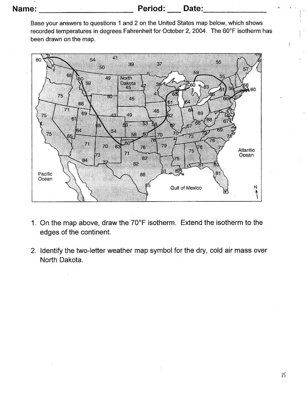
2 Name: Date: ABSTRACT T AND RATIONALE A topographic map is a type of map that depicts the detail and quantitative representation of an area that is both natural and human made. Government agencies, hikers, environmental consultants, military officials, oil companies all use topographic map for long range planning and finding natural resources. The first topographic map was made in the 1800ss by USGS (US geologic survey) and continues to remain an indispensable tool for the science classrooms. TASK STATEMENT/PROBLEM BASED LEARNING/REAL WORLD PROBLEM: You have been asked by the Bedford Planning Commission to design a hiking traill system. These criteria must be followed exactly for your proposal to be accepted by the Planning Commission. In other words, your grade on this project depends on how well you follow the criteria and how detailed your plan is. Good luck and happy planning! Criteria for planning your hiking trail system: Trails must have easy access from the road Trails must have an area next to the road for a parking lot The trails must cover at least four different habitats (stream Beginner trail must: Be no longer than 5 miles (use the map scale provided) Be a looping trail (begin and end at the same spot) Have a gradient no greater than 150 feet per mile Travel through or near at least three different habitats Intermediate/Advanced trail must: Be between 5 and 10 miles long Begin and end at a road with a park access Have a gradient of no greater than 500 feet per mile Travel through or near at least four different habitats Plan requirements: For full credit your plan must include the following items to be handed in 1. The map with all trails, parking lot and picnic areas drawn and labeled 2. A data sheet describing your trails including a. length of trail b. maximum gradient c. number of times a stream is crossed (number of bridges to be built) d. habitats that are crossed e. any other interesting feature
3 Name: Date: Anticipat tion Guideline (Topographic Map) Read page#53-56 in your Earth Science Textbook. Base on the reading; decide whether or not each statement below is true (yes) or False (no). If the statement is no, please indicate the page# and line# where the correct answer is located inn the text. In addition, be sure to correct the wrong word in the statement with the correct vocabulary. You may only fill out yes or no on one side of the table. The other side of the table will be done by you after hurricane topics. Yes No Statements Topographic Map depicts features of a landform through the use of contour lines Yes No Page# Line# The relief of a map shows the symbolss of Earth s surface The scale of 1: 63,360 is for 7.5 minute map Contour lines connect areas of the same pressure The difference in elevation between two consecutive contour lines is call contour interval Benchmark is a location whose approximate elevation is shownn If the contour lines are far apart, the land would be flat Contour lines may form circles or ovals, these indicate hills, ridges, or mountains Topographic maps can be used to determine the direction of river flow as well.


4 Name: Date: Read page #53 56 in your Earth Science Textbook. Find the vocabularies in the text, and then define each of thee vocabulary in your own words. The images below are there to provide you with mental imageries. Find the definition of these words AND label them on the diagram. In addition to the definition, label the vocabulary worlds on the diagram Label on the map an area of high relief and low relief 1. Contour Lines 2. Contour interval 3. Index Contour lines 4. Relief 5. Magnetic Declination 6. Slope/Gradient minute map vs. 15 minute map
 3. What is the highest possible elevation at location B?")
 ) 6.")
 10.")

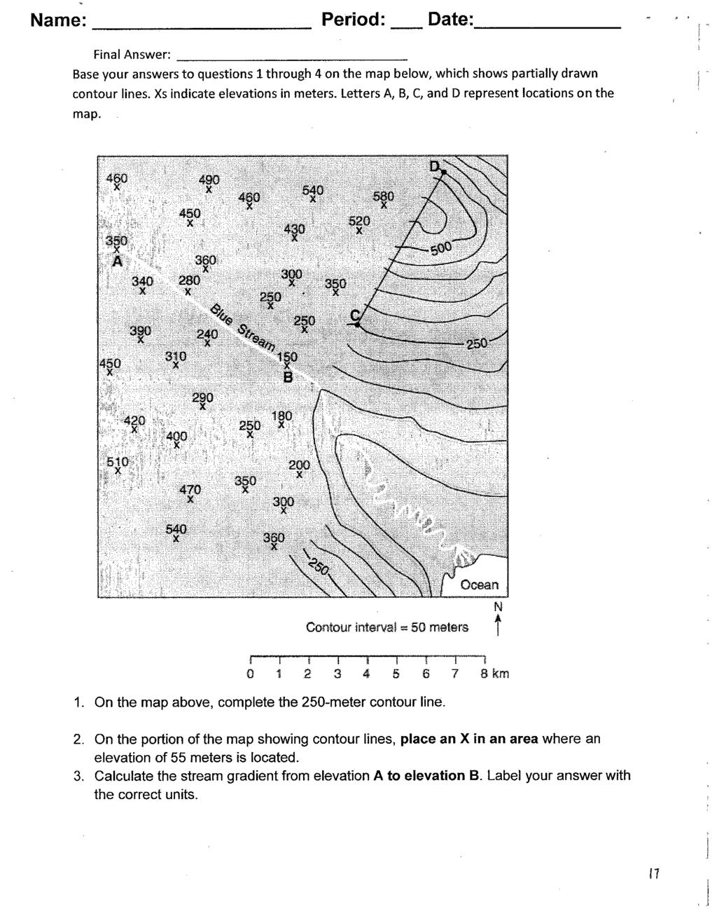
5 Name: Date: Red River Contours Ocean 1. Label all the contour lines values on the map. 2. What is the contour interval of this map? (unit please!!!!!) 3. What is the highest possible elevation at location B? (unit please) 4a) Which of the two hills is higher? 4b) How much higher? (unit please!!!!) 5. By means of the map scale, measure the distance from the top of hill B to the top of hill A. (unit please!!!!) ) 6. Which side of hill A has the steepest slope? 7. How can you telll whether a land form has steep or gentle slopes? 8. In what direction from hill A is hill B? 9. What is the elevation above sea level of hill A? (unit please!!!!!) 10. In what direction is the Red River flowing? 11. How does a contour map show the direction in which a river is flowing? 12. Shade the area on the map which would be under water if the sea level rose 40 feet. 13. Calculate the gradient of the Red River from point D to the ocean.

 How long is this island? 1. b) The long part runs which direction? 2.")


 How do you know which side of the island is steepest?")
 How do you know which side of the island is gentlest? 7.")
6 Working with Contour Maps Name: Date: Figure A Figure A shows an island. Figure B shows a contour map of this island. Answer the questions below by studying the contour map 1. a) How long is this island? 1. b) The long part runs which direction? 2. a) How wide is this island? 2. b) The wide part runs which direction? 3. This island starts at sea level. How do you know? ( Look only at the contour map.) 4. What is the contour interval of this map? 5 a) Whichh side of the island has the steepest slope? 5 b) How do you know which side of the island is steepest? 6 a) Whichh side of the island has the gentlest slope? 6 b) How do you know which side of the island is gentlest? 7. How high is the peak of this island? 8. Compare the drawing of the island with the contour map a) Whichh one gives more information? b) Whichh one is more accurate? c) Whichh one is more useful?


7 Name: Date: By compass direction 9a) the side of this landform has the steepest slope. 9b) the side of this landform has the gentlest slope. 10. The contour interval of this map is meters. 11. The lowest elevation shown is meters. 12. Which of these heights could be the exact elevation of the peak?? a) 520 meters b) 420 meters c) 475 meters Gradient = change in elevation distance 13. What is the change in elevation between point a to point b? 14. What is the distance between a and b? 15. Whichh is the gradient between point a and b?


 the mouth of the stream? 17.")

8 Name: Date: STREAMS The head of a stream is the place where it starts. The place where it ends, in a lake or ocean, is called the mouth. Look at the figure D below for the following questions. 16. What letter is at a) the head of the stream? b) the mouth of the stream? 17. Where contour lines cross a stream, they 18. At a stream, contour lines seem to form arrows. Each arrow points a) toward the (head, mouth) of the stream. b) (upstream, downstream) c) (toward, away from) the direction off flow. Figure D
9 Name: Date: Making a Profile
10 Name: Date: Making A Topographic Profile I 30 A B

11 Name: Date: Making A Topographic Profile II A B


12 Name: Date: The topographic map of an island is shown below. Elevation is expressed in feet. Points A, B, C and D are locations on the island. A triangulation points shows the highest elevation on the island. On the grid below, construct a topographic profile representing the cross-sectional view between point A and point B, following the directions below. What is the gradient in feet/mile along the straight line from point C to point D Write the equation Substitute Solve with units
13
14
15
16
17
18
19
20
21 Name: Date: Equator (Latitude) 30º 10º 10º A 0º 0º Prime Meridian (Longitude) A:, B:, C:, Latitude: Equator: Poles: Longitude: Prime Meridian: International Date Line: B C N Prime Meridian 30 A W º 10 B C 20 0º, 0º Equator 30 S A:, B:,

22 Name: Date: Express latitude and longitude to the nearest minutes BINGHAMTON:, ALBANY: ITHACA:,, N, W: N, W: N, W:
 map of NYS and determine with to the nearest ¼ of a degree the Latitude & Longitude of the following cities: a. Massena - b. Watertown - c. Elmira - d. Rochester - Remember when estimating ¼ or.")
23 Name: Date: 1. Give the Latitude and Longitude of the following points based on the above map. Remember to use the proper format A. C. D. B. 2. Use your ESRT (p.3) map of NYS and determine with to the nearest ¼ of a degree the Latitude & Longitude of the following cities: a. Massena - b. Watertown - c. Elmira - d. Rochester - Remember when estimating ¼ or.25 o = 15 ½ or.50 o = 30 ¾ or.75 o = 45
24 Rubric for Topographic Map Unit INDICATORS Reading contour map Calculating contour maps BEGINNING Novice Able to define and explain contour map vocabularies such as contour interval, gradient, index contour and more (see packet for list) Can find the gradient formula on the reference table DEVELOPING Apprentice Identify landmarks such as river, mountain, depression, by using contour map features Explain the process of greenhouse effect Identify and explain how unnatural climate (human impact) factors affect climate ACCOMPLISHED Practitioner Using contour lines to identify areas of river flow and the direction of river flow Identify sea level and highest elevation of a peak Successfully state contour intervals with correct units Successfully state latitude and longitude of the map in the nearest degree and minutes Identify and explain areas of steepest gradient Accurately label peaks and depression Able to measure the distance of two points on the map Able to find the difference in elevation Able to measure and calculate gradient Able to measure and calculate gradient for other isoline map EMPLEMPLARY Expert All practitioner plus Describe and identify high and low topographic relief of the map Explain in detail the meaning of a7.5 minute map and 15 minute map List various use of topographic map All practitioner plus Be able to calculate gradient in correct units Convert degree of latitudes into angular distance units. Creating contour maps Creating 3D models from contour maps to identify landmarks Creating elevation profiles and 3D Google Earth tour Creating 2D profile on the topographic map with a provided and labeled grid Creating contour maps from field values Able to create a beginner trail system on a topographic map with given criteria All practitioner plus Creating 2D profiles with self-labeled grid. Successfully creating different types of isoline maps Able to create an advanced trail system on a topographic map with given criteria
Regents Earth Science Unit 1 Earth Dimensions
 Regents Earth Science Unit 1 Earth Dimensions www. BarnesWeb.org 2014-15 edition Name: Name: OBJECTIVES Correctly define: isolines, gradient, topographic map, contour interval, hachured lines, profile,
Practice Packet Topic 2: Measuring Earth
 Practice Packet Topic 2: Measuring Earth Vocabulary: Lesson 1: Lesson 2: Name: Lesson 3: Mini Lesson: Latitude Longitude Pre-Test 1. To locate exact places on the earth, one must look at a. The intersecting
Guided Notes Topographic Maps
 Guided Notes Topographic Maps Map scale Straight line distance Curved line distance Rules of Isolines Contour Lines Hachured Lines Possible elevations Slope & Gradient Direction of River Flow Topographic
Earth s Dimensions. Earth s shape. Evidence. Spheres of Earth: 1) Lithosphere- includes: 2) Hydrosphere includes: 3) Atmosphere - Earth Dimensions 23
 Lithosphere- includes: 2) Hydrosphere includes: 3) Atmosphere - Earth Dimensions 23") Earth s Dimensions Earth s shape Evidence Spheres of Earth: 1) Lithosphere- includes: 2) Hydrosphere includes: 3) Atmosphere - Earth Dimensions 23 Selected Properties of Earth s Atmosphere: Earth Science
Earth s Dimensions Earth s shape Evidence Spheres of Earth: 1) Lithosphere- includes: 2) Hydrosphere includes: 3) Atmosphere - Earth Dimensions 23 Selected Properties of Earth s Atmosphere: Earth Science
Homework - Topographic Maps and What They Mean - Standard Earth Science
 Name: Mr. Schwartz Earth Science Period: Date: /10 Homework - Topographic Maps and What They Mean - Standard Earth Science Read pages 46-47 and 53-56 in your text. Then, answer the questions. Don t forget
B. Topographic maps are also called. contour maps
 Topographic Maps Introduction A. Topographic maps are essential tools in geologic and engineering studies because they show the configuration of Earth's surface in remarkable detail and permit one to measure
Chapter 3 Models of the Earth. 3.1 Finding Locations on the Earth. 3.1 Objectives
 Chapter 3 Models of the Earth 3.1 Finding Locations on the Earth 3.1 Objectives Explain latitude and longitude. How can latitude and longitude be used to find locations on Earth? How can a magnetic compass
Latitude and Longitude
 U n i t 3 M a p p i n g P a g e 1 Latitude and Longitude Note: These coordinates are always expressed LATITUDE/LONGITUDE!!! Coordinate System: Using and to find your position on Earth. LATITUDE LATITUDE
Topographic Maps. More than a Road Map
 Topographic Maps More than a Road Map What is a Topographic Map? Scaled representation of features on the surface of the Earth such as roads, rivers, and plains Provides information about land elevations
MAPPING THE EARTH HOW DO YOU FIND A LOCATION ON THE EARTH?
 MAPPING THE EARTH HOW DO YOU FIND A LOCATION ON THE EARTH? UNIT TOPICS TOPIC 1: LATITUDE & LONGITUDE TOPIC 2: FIELD MAPS TOPIC 3: TOPOGRAPHIC MAPS TOPIC 4: NYS LANDSCAPES TOPIC 1: LATITUDE & LONGITUDE
Class Notes: Mapping the Earth
 Name: Date: Period: Mapping the Earth The Physical Setting: Earth Science Class Notes: Mapping the Earth I. Latitude and Longitude Map -! Latitude -! Also called These lines intersect Equator -! The North
***When doing the lab report write-up, be sure to follow the guidelines.***
 Topographic Maps Lab Vocabulary: topography - study of the shapes and features of the earth's surface elevation - height above sea level bench mark - a point that has been accurately measured for its position
Using Map and Compass Together
 Using Map and Compass Together In situations where you foresee a potential evacuation on foot, where there are no roads, and no indication as to the direction of travel (i.e., road signs), it is recommended
APPENDIX A GLOSSARY. Appendix A.1
 APPENDIX A GLOSSARY Appendix A.1 Appendix A.2 Back Bearing A back bearing is measured from the object to your position. It is the exact opposite of a direct bearing. Base Line An imaginary line on the
Topographic Maps and Landforms Geology Lab
 Topographic Maps and Landforms Geology Lab Ray Rector: Instructor Today s Lab Activities 1) Discussion of Last Week s Lab 2) Lecture on Topo Maps and Elevation Contours 3) Construct Topographic Maps and
Notes and Summary pages:
 Topographic Mapping 8.9C Interpret topographical maps and satellite views to identify land and erosional features and predict how these shapes may be reshaped by weathering ATL Skills: Communication taking
OBJECTIVES. Identify the means by which latitude and longitude were created and the science upon which they are based.
 Name: OBJECTIVES Correctly define: isolines, gradient, topographic map, contour interval, hachured lines, profile, latitude, longitude, hydrosphere, lithosphere, atmosphere, elevation, model EARTH S SPHERES
What is a map? A Map is a two or three-dimensional model or representation of the Earth s surface. 2-Dimensional map
 What is a map? A Map is a two or three-dimensional model or representation of the Earth s surface. 2-Dimensional map What is a Map Projection? Planar Projection Projection A Projection is a mathematical
Topographic Maps and Profiles
 Name: Date: Period: Earth Science Foundations The Physical Setting: Earth Science CLASS NOTES! Topographic Maps [contour maps] -! Topographic maps show three-dimensional shapes in two dimensions Elevation
1. Identify the Earth motion that provides the basis for our system of local time and time zones.
 Base your answers to questions 1 through 4 on the map below and on your knowledge of Earth science. The map shows the four time zones and some latitude and longitude lines across the continental United
1. The topographic map below shows a depression contour line on Earth's surface.
 1. The topographic map below shows a depression contour line on Earth's surface. Points A, B, C, and D represent surface locations. Contour line elevations are in feet. Which profile best shows the topography
Earth Science Regents Reading Topographic Maps
 Earth Science Regents Reading Topographic Maps Name Period Quick Tutorial on Degrees, Minutes, and Seconds of Latitude and Longitude A degree of latitude on the surface of the earth is about 70 miles long.
Topographic Map Series:
 DEFINITION OF A MAP A MAP IS A GEOGRAPHIC PREPRESENTATION OF A PORTION OF THE EARTH S SURFACE DRAWN TO SCALE, AS SEEN FROM ABOVE. IT S USES COLORS, SYMBOLS AND LABELS TO REPRESENT FEATURES FOUND ON THE
Name Class Date. For each pair of terms, explain how the meanings of the terms differ.
 Skills Worksheet Chapter Review USING KEY TERMS For each pair of terms, explain how the meanings of the terms differ. 1. true north and magnetic north 2. latitude and longitude 3. equator and prime meridian
Chapter 3 SECTION 1 OBJECTIVES
 Chapter 3 SECTION 1 OBJECTIVES Distinguish between latitude and longitude and locate coordinates on maps. Explain how latitude and longitude can be used to locate places on Earth s surface. Explain the
EARTH SCIENCE KEY UNIT 2-H
 EARTH SCIENCE KEY UNIT 2-H UNIT 2 MODELS & DIMENSIONS OF EARTH I. Model = ANYTHING THAT REPRESENTS THE PROPERTIES OF AN OBJECT OR SYSTEM A. Types and examples of models: 1. PHYSICAL Provides us with information
5. The topographic map below shows a lake and two rivers.
 Mapping A B1 1. The diagram below shows latitude measurements every 10 degrees and longitude measurements every 15 degrees. What is the latitude and longitude of point X? 5. The topographic map below shows
Geology 101 Lab Worksheet: Topographic Maps
 Geology 101 Lab Worksheet: Topographic Maps Name: Refer to the Topographic Maps Lab for the information you need to complete this worksheet (http://commons.wvc.edu/rdawes/g101ocl/labs/topomapslab.html).
Laboratory Exercise #2 Introduction to Quadrangle Maps
 page - 1 Laboratory Exercise #2 Introduction to Quadrangle Maps A. Introduction to Quadrangle Maps The United States Geological Survey has developed a nationwide series of quadrangle maps that cover small
56H. This system allows definition of points on the Earth s surface to within 100 meters. Page 20. Navigation Systems Basics of Maps
 Grid References Many maps are provided with the standard grid overlaying them. This provides a simple and accurate method for finding features on the map. It is a network of intersecting parallel lines
Laboratory Exercise #2 Introduction to Quadrangle Maps
 page - Laboratory Exercise #2 Introduction to Quadrangle Maps A. Introduction to Quadrangle Maps The United States Geological Survey has developed a nationwide series of quadrangle maps that cover small
Date: TEN UNIT. Earth. History. and
 Name: Date: UNIT TEN Geologic Time and Earth History *Dedicated to: Name: Date: ABSTRACTT AND RATIONALE The Earth is very old 4.5 billion years or more according to scientific estimates. Most of the evidence
Practice Questions. (4) It connects points of equal air temperature. Which of the following items is a model? lithosphere and the troposphere?
 It connects points of equal air temperature. Which of the following items is a model? lithosphere and the troposphere?") Practice Questions Directions Review the Test-Taking Strategies section of this book. Then answer the folowing questions. Read each question carefuly and answer with a correct choice or response. Part
Practice Questions Directions Review the Test-Taking Strategies section of this book. Then answer the folowing questions. Read each question carefuly and answer with a correct choice or response. Part
AS 410 Land Navigation. Chpt 4-1
 AS 410 Land Navigation Chpt 4-1 Overview Types of Maps Map Legends / Scales Latitude and Longitude Orienteering Why? Why important to learn how to read a compass and map? No cell phone coverage Mountain
Topographic Maps. Take Notes as you view the slides
 Topographic Maps Take Notes as you view the slides Lesson Objectives Define a topographic map and state its uses. Describe how contour lines show the elevations, shape, and slope of the land. Identify
Mapping Earth. How are Earth s surface features measured and modeled?
 Name Mapping Earth How are Earth s surface features measured and modeled? Before You Read Before you read the chapter, think about what you know about maps Record your thoughts in the first column Pair
Maps. 3. Which altitude of Polaris could be observed in New York State?
 Name: Date: 1. For an observer in New York State, the altitude of Polaris is 43 above the northern horizon. This observer s latitude is closest to the latitude of A. New York City B. Utica 3. Which altitude
Compass Basics. Quick Map Basics Review For Compass Use
 Compass Basics Quick Map Basics Review For Compass Use A topographic map tells you where things are and how to get to them, whether you're hiking, biking, hunting, fishing, or just interested in the world
Midterm Review #4 -FR
 Base your answers to questions 1 through 3 on the diagram below, which represents a north polar view of Earth on a specific day of the year. Solar times at selected longitude lines are shown. Letter A
Lab Topographic Maps. Name: Partner: Purpose. Background Information
 Lab Topographic Maps Name: Partner: Purpose The purpose of this lab is to familiarize you with graphic representations of the Earth s surface primarily maps. Simple line maps show the spatial relationship
Butte County Fire Department
 Butte County Fire Department Basic Land Navigation Verification Sheet I verify that Print Supervisor s name has completed the Print Employee s name Basic Land Navigation self study guide on. Date Attached
Guided Notes Unit 1. Maps & Measurements
 Guided Notes Unit 1 Maps & Measurements Checkpoint Questions Deep Space 1) In which list are celestial features correctly shown in order of increasing size? a. galaxy solar system universe planet b. solar
NAME: Log onto YouTube and search for jocrisci channel.
 NAME: Log onto YouTube and search for jocrisci channel. TOPO MAPS (Videos 2.3a, 2.3b, 2.4, 2.5, 2.6, 2.7, 2.8 ESRT 1b part on gradient) 1. You will be given a series of elevations and you will be asked
C) D) 3. Which pie graph correctly shows the percentage of elements by volume in Earth s troposphere? A)
 D) 3. Which pie graph correctly shows the percentage of elements by volume in Earth s troposphere? A)") 1. Precise measurements of the Earth indicate that its polar diameter is A) shorter than its equatorial diameter B) longer than its equatorial diameter C) the same length as its equatorial diameter 2.
1. Precise measurements of the Earth indicate that its polar diameter is A) shorter than its equatorial diameter B) longer than its equatorial diameter C) the same length as its equatorial diameter 2.
Basic Map Skills for the Outdoors
 Geography 80-20 80% of what there is to know, for 20% of the sweat Basic Map Skills for the Outdoors Map Scale Map source: US Geological Survey Four ways to indicate map scale: Representative fraction
Introduction to Contour Maps
 Your web browser (Safari 7) is out of date. For more security, comfort and Activityengage the best experience on this site: Update your browser Ignore Introduction to Contour Maps What information does
CONTOUR MAPS This Enrichment4You e-guide provides a brief overview of contour maps In this e-guide you will: Sample file
 GEOLOGY CONTOUR MAPS CONTOUR MAPS This Enrichment4You e-guide provides a brief overview of contour maps In this e-guide you will: *Learn Basic Facts About Contour Maps *Make a 3-D Contour Map Geology Contour
Approximately how many inches of average yearly precipitation does Rochester, New York, receive?
 1. Base your answer to the following question on the isoline map below, which shows the average yearly precipitation, in inches, across New York State. Approximately how many inches of average yearly precipitation
STAAR Science Tutorial 40 TEK 8.9C: Topographic Maps & Erosional Landforms
 Name: Teacher: Pd. Date: STAAR Science Tutorial 40 TEK 8.9C: Topographic Maps & Erosional Landforms TEK 8.9C: Interpret topographic maps and satellite views to identify land and erosional features and
Unit 1: Mapping and Astronomy
 Unit 1: Mapping and Astronomy 1 Do Now In your notebook, write your thoughts on the following: -What do you know about the beginning location and trajectory of the most recent hurricanes (Harvey or Irma)?
Do Now. Copy the ques:on below and write down an. Sketch a profile of the books on the front table.
 Do Now Copy the ques:on below and write down an answer Sketch a profile of the books on the front table. Measurements Contour Lines How do we represent Eleva:on on a flat piece of paper? Eleva?on height
Orienteering Maps & Map Reading Latitude and Longitude Scale
 Orienteering Maps & Map Reading A map is a two-dimensional representation of the three-dimensional world you'll be hiking in. All maps will have some basic features in common and map reading is all about
Earth Science Unit 1 Test
 Earth Science Unit 1 Test Multiple Choice Identify the choice that best completes the statement or answers the question. 1. The study of meteorology involves the study of a. climate. c. animals. b. outer
Name Date Class. a. High elevation and high relief b. High elevation and level surface c. Flat land and low relief
 Exploring Earth s Surface (pp. 21 27) This section describes factors that determine the shape of Earth s land surface. The section also describes how scientists divide Earth into four spheres. Use Target
Chapter 1 Overview of Maps
 Chapter 1 Overview of Maps In this chapter you will learn about: Key points when working with maps General types of maps Incident specific maps Map legend and symbols Map sources A map is a navigational
Topographic Maps Self-Instruction Lab (2016 edition) Geology 100 David Harbor s Section. 12 inches x 1 mile
 Geology 100 David Harbor s Section. 12 inches x 1 mile") Topographic Maps Name Self-Instruction Lab (2016 edition) Geology 100 David Harbor s Section Topographic maps are an important aid for a geologist, but maps are also useful for hikers, bicyclists, and
Topographic Maps Name Self-Instruction Lab (2016 edition) Geology 100 David Harbor s Section Topographic maps are an important aid for a geologist, but maps are also useful for hikers, bicyclists, and
MAP STUDY: INTERPRETATION OF SURVEY MAPS
 MAP STUDY: INTERPRETATION OF SURVEY MAPS Types and Elements of Maps Maps are drawn to represent the Earth on a piece of paper. Maps are used widely to represent the Earth. Maps use signs and symbols in
Map Reading & Compass Use
 Spring 2013 Kestrel Land Trust Page 2 / 10 Contents Map Basics... 3 Map Types... 3 Terrain Association... 4 Estimating Distance: Pacing... 4 Contour Lines... 5 Navigating with a Compass... 6 Compass Types...
Date: UNIT TWO. and. Climate. *Dedicated to
 Date: UNIT TWO Climate factors and impacts *Dedicated to Date: ABSTRACT AND RATIONALE Earth s climate is always changing. Climatic variability, including changes in the frequency of extreme events (like
About places and/or important events Landmarks Maps How the land is, hills or flat or mountain range Connected to maps World Different countries
 What do you think you know about geography? About places and/or important events Landmarks Maps How the land is, hills or flat or mountain range Connected to maps World Different countries What do you
Erosional Features. What processes shaped this landscape?
 Have you ever looked at the land around you and wondered what processes shaped what you see? Perhaps you see mountains, valleys, rivers, or canyons. Do you know how long these geologic features have been
UNIT 1C. USING TOPOGRAPHIC MAPS WHERE IN THE WORLD... ARE YOU?
 UNIT 1C. USING TOPOGRAPHIC MAPS WHERE IN THE WORLD... ARE YOU? TIME 60-90 minutes LEVEL All BENCHMARKS Next Generation Science Standards MS-LS1.D Science & Engineering Practices Developing and Using Models
EROSIONAL FEATURES. reflect
 reflect Have you ever looked at the land around you and wondered what processes shaped what you see? Perhaps you see mountains, valleys, rivers, or canyons. Do you know how long these geologic features
Scientists observe the environment around them using their five senses.
 Earth Science Notes Topics 1: Observation and Measurement Topic 2: The Changing Environment Review book pages 1-38 Scientists observe the environment around them using their five senses. When scientists
California Cadet Corps Curriculum on Maps and Navigation. Map Reading LEADERS KNOW THE WAY
 California Cadet Corps Curriculum on Maps and Navigation Map Reading LEADERS KNOW THE WAY 5/22/2017 Map Reading Agenda A1. Introduction to Maps A2. Topographical Map Basics A3. Elevation and Terrain Features
 Chapter 2 Mapping Our World Picture: Mount Capulin, Raton, NM Cinder Cone Volcano ://3.bp.blogspot.com/_sKz1KwXRzcg/SzFzM52gIoI/AAAAAAAAABk/hguBAT80pk0/s320/capulin.jpg http://www.peteandmelissa.com/images/oklahoma/p1020190.jpg
Measuring Planet Earth Regents Review. 2. State the altitude of Polaris as seen by an observer at the North Pole.
 Name Measuring Planet Earth Regents Review ase your answers to questions 1 through 3 on the diagram below, which represents a north polar view of Earth on a specific day of the year. Solar times at selected
Elementary Social Studies Content Area Assessment Task. Winter 2010 EDUC 203
 1 Elementary Social Studies Content Area Assessment Task Winter 2010 EDUC 203 Students: Fourth grade class in Watsonville, CA. Approximately 90% Latino, primarily of Mexicandescent. About 80% participate
Mid Term Prep-Latitude and Longitude
 1. What is the approximate altitude of Polaris at Syracuse, New York? A) 43 B) 47 C) 76 D) 90º 2. If an observer on Earth views Polaris on the horizon, the observer is located at the A) equator (0 ) B)
Map Skills Lesson 1. Materials: maps, pencils, Lesson 1 Worksheet, strips of paper, grid paper
 Map Skills Lesson 1 Use cardinal directions, map grids, scales, and titles to locate places on a map. Interpret a map using information from its title, compass rose, scale, and legend. Vocabulary: map,
Midterm Review. 58. Which cross section best represents the topographic profile along the straight line from point Y to point Z on map B?
 Base your answers to questions 56 through 58 on the two topographic maps below. A grid system of numbers and letters appears along the edge of each map to help locate features. Both maps show elevations
Activities: Map and Compass
 Activities: Map and Compass Determining General Directions Modified with permission from Outdoor Living Skills Series: Map and Compass, Missouri Department of Conservation Overview: Students use the sun
Butte County Fire Department
 Butte County Fire Department Basic Land Navigation Verification Sheet I verify that Print Supervisor's name Print Employee's name has completed the Basic Land Navigation self study guide on Date Attached
USING THE MILITARY LENSATIC COMPASS
 USING THE MILITARY LENSATIC COMPASS WARNING This presentation is intended as a quick summary, and not a comprehensive resource. If you want to learn Land Navigation in detail, either buy a book; or get
In order to be adequately prepared for a test on this topic you should be able to:-
 Topic 2: MAPPING In order to be adequately prepared for a test on this topic you should be able to:- 1. Find and also provide both FOUR and SIX figure Area and Grid References 2. Calculate distances both
Topo Map Tidbits. Adapted from: An original Creek Connections activity. Creek Connections, Box 10, Allegheny College, Meadville, Pennsylvania, 16335
 Topo Map Tidbits Adapted from: An original Creek Connections activity. Creek Connections, Box 10, Allegheny College, Meadville, Pennsylvania, 16335 Introduction to Topographic Maps Grade Level: Basic Duration:
King County Explorer Search and Rescue. Course B Map & Compass
 King County Explorer Search and Rescue Course B Map & Compass Disclaimer The intent of this presentation is to provide a basic overview of maps, compasses, and location finding. It is not meant to be a
REVISION: MAPWORK 18 SEPTEMBER 2014
 REVISION: MAPWORK 18 SEPTEMBER 2014 Lesson Description In this lesson we revise: Various mapwork calculations Summary Relative Position Bearing is the angular (angle) distance between two points True Bearing
Year 7 GEOGRAPHY Skills Booklet Assessment Task
 Year 7 GEOGRAPHY Skills Booklet Assessment Task Year/ Subject: Year 7 Geography Task - Skills Booklet Task Weighting: 20% Due Date: T2 W1 2018 Geographical Tools 10% Communication 10% TOTAL FOR TASK 20%
A) greatest in diameter at the Equator C) 53 N B) Albany D) 13.8 billion years B) cosmic background radiation
 greatest in diameter at the Equator C) 53 N B) Albany D) 13.8 billion years B) cosmic background radiation") 1. Measurements taken from space show the Earth to be A) greatest in diameter at the Equator B) greatest in diameter at the poles C) a perfect sphere D) pear shaped 2. The diagram below represents an observer
1. Measurements taken from space show the Earth to be A) greatest in diameter at the Equator B) greatest in diameter at the poles C) a perfect sphere D) pear shaped 2. The diagram below represents an observer
Essential Questions What are the major physical components of the world, and how are they represented on a map? 3.4
 Third Grade Social Studies Unit One Six Weeks GEOGRAPHY Originally compiled by Russellville In order for students to understand that geography influences the development of a region as well as the interactions
Bellringer Notes 01/07/2016 to 02/25/2016
 Bellringer Notes 01/07/2016 to 02/25/2016 Bellringer 01/07/2016 Examine the following scene and identify who s statement best describes the forces on the canoe. 20 N Upstream 15 N Downstream Robert Forces
Background Information
 Oceanography LAB #1: Marine Charts and Navigation Background Information Latitude and Longitude A coordinate is an address a means of designating location. Most coordinate systems involve a network of
Navigating with Map & Compass. Nevada County Sheriff s Search & Rescue
 Navigating with Map & Compass Nevada County Sheriff s Search & Rescue Objectives Very Practical Teach you how to go from point A to point B Go from the wilderness (real world) to a map and visa versa Agenda
NAME DATE TOPOGRAPHIC MAPS. Activity 1: Topographic Map Investigation I: More Than a Road Map
 NAME DATE PARTNER(S) TOPOGRAPHIC MAPS Now you have seen how topographic maps can be generated to present the elevation of a terrain. Let s look at some topographic maps and learn how to interpret them.
Unit 1 Test. Version A
 For each statement or question, write on your separate answer sheet the number of the word or expression that, of those given, best completes the statement or answers the question. Some questions may require
1. Label a few examples of lines of latitude and lines of longitude on the globe above left.
 Oceanography 2 Location, Direction, and Distance on Nautical Charts Please read Appendix III in the textbook for reference. Learning Objectives for the first nautical chart Lab 1. Use the latitude-longitude
Canadian Mapping Big Book
 Canadian Mapping Big Book Grades 4-6 Written by Lynda Golletz Illustrated by S&S Learning Materials About the Author: Lynda Golletz was an elementary school teacher for thirty-three years. She is the author
Elevations are in meters above mean sea level. Scale 1:2000
 12.001 LAB 7: TOPOGRAPHIC MAPS Due: Monday, April 11 PART I: CONTOURING AND PROFILES (20 PTS) 1. Contour this area map using a 5 meter contour interval. Remember some fundamental rules of contour lines,
GEOL 3700 STRUCTURE AND TECTONICS LABORATORY EXERCISE 3
 GEOL 3700 STRUCTURE AND TECTONICS LABORATORY EXERCISE 3 Goals: 1. Improve your map-reading and map-making skills. 2. Learn to generate and interpret structure contour maps. 3. Learn to generate and interpret
Mapping Earth Review Note Cards
 Review Note Cards Spheres of Earth Atmosphere- Layer of gases Hydrosphere- All liquid water Lithosphere- Solid surface Biosphere-Living Portion Cryosphere-Ice Portion Evidence that the Earth is Round The
Parts of a Map. Map Skills. The Title. There are 4 main parts of a map: The Title The Compass Rose The Map Key The Scale
 Map Skills Parts of a Map There are 4 main parts of a map: The Title The Compass Rose The Map Key The Scale The Title The title of the map is usually at the top and describes the topic of the map Example:
Topographic Maps Knowledge of Maps What are they? What are they used for? Why are they important?
 Topographic Maps Knowledge of Maps What are they? What are they used for? Why are they important? Topographic Maps Maps that show the change in elevation of land. Elevation is the height of land above
Different types of maps and how to read them.
 Different types of maps and how to read them. A map is a picture or representation of the Earth's surface, showing how things are related to each other by distance, direction, and size. Maps have been
Earth Science: Chapter 2 Assessment
 Earth Science: Chapter 2 Assessment Do not write on this text booklet. Write the letter of the correct answer on your answer sheet. SECTION 1: Multiple Choice (50 points) Choose the letter of the BEST
Date: Weat. ther. *Dedicated to:
 Name: Date: UNIT ONE (partii) Weat ther Forecasting *Dedicated to: Name: Date: ABSTRACT T AND RATIONALE The USA has the world s wildest weather. A normal year brings hurricanes, blizzard, desert dryness
Map reading notes. It is a very useful kind of map that shows the topography of an area, i.e whether it is flat, undulating, rugged or mountainous
 Introduction Map reading notes In the course of 2 or 3 years course, Candidates will be exposed to topographical maps from tropical countries such as Mauritius, Tanzania, Zimbabwe and Jamaica. Many of
Topographic Maps: Background
 Topographic Maps: Background Introduction From Dr. Terry Swanson, University of Washington, ESS 101 Lab, Geologic Techniques, and Dr. David Kendrick, Hobart and William Smith Colleges, Geneva, NY Geoscientists
Create A Watershed Profile
 Name Date Follow the steps below with Chesapeake Bay FieldScope to create a watershed profile for your location. Part 1. Take a trip down your tributaries. Create A Watershed Profile 1. Find your field
Chapter 02 Maps. Multiple Choice Questions
 Chapter 02 Maps Multiple Choice Questions 1. Every projection has some degree of distortion because A. a curved surface cannot be represented on a flat surface without distortion. B. parallels and meridians