Characteristics and processes associated with the development of Hilly Landscapes
|
|
|
- Berniece Bryan
- 6 years ago
- Views:
Transcription

1 GRADE 11 GEOGRAPHY SESSION 1: GEOMORPHOLOGY I (TOPOGRAPHY) Key Concepts In this lesson we will focus on summarising what you need to know about: Topography associated with Horizontally Layered Rocks Topography associated with Inclined/Tilted Rock Strata Topography associated with Massive Igneous Rocks X-Planation Topography Associated with Horizontally Layered Rocks Characteristics and processes associated with the development of Hilly Landscapes In areas where the climate is arid there is not enough water for sheet-wash to occur. Water will run unevenly down slopes eroding gullies in certain places. The slopes are therefore rugged and uneven. There is little chemical weathering and soils are thin.


2 Characteristics and processes associated with the development of Basaltic Landscapes In areas where the horizontal strata are formed from lava flows, basaltic plateaus will form. Rivers will cut into joints and cracks forming steep cliffs and deep valleys called gorges A term applied to those basaltic lavas that occur as vast composite accumulations of horizontal or sub horizontal flows, which, erupted in rapid succession over great areas, have at times flooded sectors of the Earth's surface on a regional scale They are generally believed to be the product of fissure eruptions. One or a succession of hightemperature basaltic lava flows from fissure eruptions which accumulate to form a plateau. Also known as flood basalt

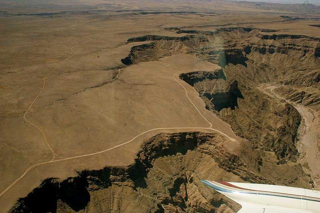
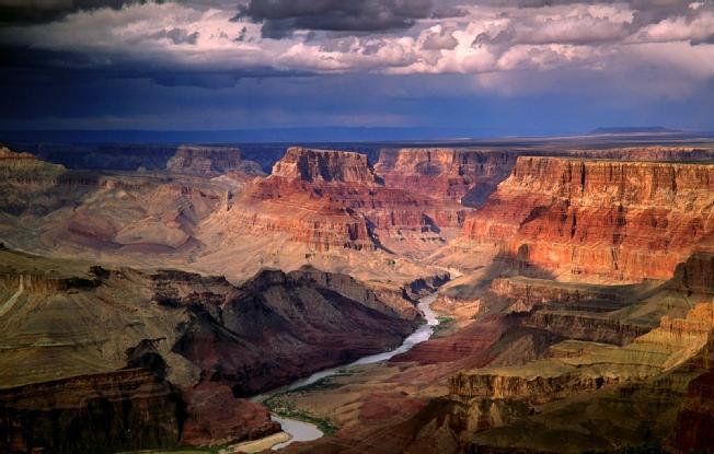
3 Characteristics and processes associated with the development of Canyon Landscapes Canyon landscapes develop where horizontal strata have varying resistance to erosion Examples of canyons in South Africa include the Fish River Canyon and Blyde River Canyon. Canyon landscapes are characterised by deep valleys and uneven slopes
4


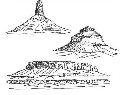
5 Characteristics and processes associated with the development of Karoo Landscapes Mesa: A mesa is an isolated, flat-topped hill or mountain with steep sides that is smaller in area than a plateau.


6 Butte: A butte is also a flat-topped hill with steep sides, though smaller in area than a mesa.
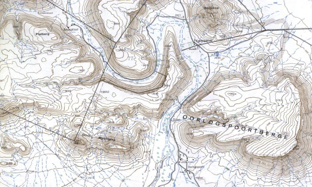
7 Horizontal Layers on Topographical Maps


8 The Concept of Scarp Retreat and Back Wasting Slopes eroding back parallel to their original position; common in dry climates where there is very little surface water runoff; also known as back wasting. Utilization of Horizontally Layered Landscapes Canyon landscapes are not attractive for settlement and agriculture. The wide valleys of these landscapes also make the construction of infrastructure quite difficult. The Karoo landscape is arid and not generally suited for agriculture or settlement. The area is, however, used successfully for sheep farming. Topography Associated with Inclined / Tilted Rock Strata What is Inclined Rock Strata Asymmetrical ridge according to the angle of a dip slope
 and they become tilted relative to their original (horizontal) position. Faulting or folding causes the strata to be tilted.")
9 Characteristics and processes associated with the development of Scarp and Dip Slopes It occurs when strata is subjected to stress (either compression, tension, volcanic intrusion or tectonic movement) and they become tilted relative to their original (horizontal) position. Faulting or folding causes the strata to be tilted. The beds may be inclined in any direction with the angle of the dip slope between 0º to 90º. Inclined strata has TWO slopes; a dip and scarp slope. Dip Slope A natural/gradual slope on the surface of the ground which is parallel to the dip of the underlying strata. OR A side on which hard layers dip and has a gentle slope. It has a GENTLE SLOPE and a RESISTANT ROCK LAYER. Scarp Slope A long steep slope or cliff at the edge of a ridge/ plateau. It has a STEEP SLOPE and a SOFTER ROCK LAYER. Characteristics and processes associated with the development of Cuesta, Homoclinal Ridge and Hogsback Ridge When the strata is weathered, asymmetrical ridges called homoclinal ridges are formed. Homoclinal ridges are where the underlying strata is tilted in the same direction and has a uniform dip angle. (rock strata dipping in one direction). Homoclinal ridges are classified according to the angle of the dip slope. There are THREE types of homoclinal ridges, namely: cuesta homoclinal ridge and hogsback ridge

10 Cuesta A ridge with a gentle dip slope and a steep scarp slope. The angle of the dip slope is 10º 25º to the horizontal. The dip slope does have fertile soil and is usually used for forestry. Example: Magaliesberg Mountain in Gauteng Cuesta Basins Cuesta basins are formed as a result of volcanic intrusions of a lopolith. The scarp slope faces downward, and the dip slope is directed inward. These hold artesian wells and can form oil traps.

11 Cuesta Dome Cuesta domes are formed as a result of volcanic intrusions of a batholith and lacollith. The scarp slope faces inward, and dip slopes faces outward.


12 Homoclinal Ridge The angle of the dip slope lies 25º 45º to the horizontal. Rivers cut poorts through the ridges. Drainage is normally trellis patterned. Example: Magaliesberg near Pretoria and Hex River Mountains in Western Cape.


13 Hogsback The angle of the dip slope is more than 45º to the horizontal. There is very little difference in the gradient of the scarp and dip slopes. Example: in Eastern Cape


14 Utilisation of Inclined Strata by Humans Cuestas 1. are used for farming 2. are used for forestry Hogsbacks 1. For recreation e.g. mountain climbing 2. For protection during war Topography Associated with Massive Igneous Rocks What are Massive Igneous Rocks? Massive igneous rocks are not stratified. They solidified at depth as a great compact mass and cooling was therefore slow. Because of this slow cooling process, there was sufficient time for large crystals to develop. These large masses can assume a variety of forms, namely, batholiths, laccoliths, lopoliths, dykes and sills as well as tors.

15 Batholiths The largest of the dome-shaped intrusive forms is a batholiths. It reaches down to such great depths, increasing in size deeper down, that it seems to have no lower limit. Even the exposed part at the Earth s surface often extends over several thousand square kilometres. Laccoliths The laccolith is much smaller than batholiths. It is also formed by the erosion of magma amongst other strata, e.g. between sedimentary layers of rock. The overlying layers have to be removed before the laccoliths itself is visible. Lopolith Lopoliths are formed in much the same way as laccoliths, but the sedimentary strata between which magma has intruded have been unable to bear the weight. The floor has collapsed to form a shallow, saucer-shaped intrusive form. Dykes and Sills Dykes and sills can be the same material from the same source. Dykes find and fill vertical structural weaknesses. If they find a weaker horizontal plane, they fill that too, forming a sill. A dyke is an intrusion into an opening cross-cutting fissure, shouldering aside other preexisting layers or bodies of rock. A sill is a tabular sheet intrusion that has been intruded between older layers of sedimentary rock, beds of volcanic lava. Granite Domes

 (2) 1.")
16 Tors X-ample Questions Question 1 Refer to the FIGURE showing topography associated with horizontally layered rocks. The 3 diagrams are not arranged in the correct order of development. 1.1 Arrange the THREE diagrams in the correct order of development by writing the letters that appear on the diagrams in the correct order. (3 x 2) (6) 1.2 The utilization of these types of landscapes, especially B, is limited. Explain the reason for this. (1 x 2) (2) 1.3 Which one of the diagrams illustrates a typical Karoo landscape? (1 x 2) (2) 1.4 Identify the landform in the diagram mentioned in QUESTION 1.3 that is typically found in the Karoo landscape. (1 x 2) (2)
 (2) 2.3 Give a reason for your answer. (1 x 2) (2) 2.4 State the TWO types of slopes generally associated with inclined rocks.")
17 Question 2 Refer to the figure below, a photograph showing an example of inclined rock strata. 2.1 Explain how rocks are bent in this type of landscape. (1 x 2) (2) 2.2 Identify the type of Cuesta evident in the photograph. (1 x 2) (2) 2.3 Give a reason for your answer. (1 x 2) (2) 2.4 State the TWO types of slopes generally associated with inclined rocks. (2 x 2) (4) 2.5 Draw a diagram to distinguish between these TWO types of slopes. (2 x 2) (4) Question 3 Refer to the figure below, showing various intrusive rock bodies. Use the diagram to complete the table by matching the terms in column A with the definitions in column B. Write only the number and the correct answer. (5 x 2) (10) Column A Column B 3.1 Batholith A. A horizontal rock formed as magma spread between layers 3.2 Laccolith B. A wall like intrusion that cuts almost vertically across existing strata 3.3 Lopolith C. Magma intrudes between sedimentary layers. The layer underneath cannot support the weight and sinks downwards creating a saucer shaped intrusion. 3.4 Dyke D. A mushroom shaped intrusion that pushes the overlying strata upwards 3.5 Sill E. The largest of all intrusive forms.
 (2) 4.")
18 Question 4 Refer to the figure below showing topography associated with massive igneous rocks. 4.1 Identify the landform evident in the picture. (1 x 2) (2) 4.2 Describe the landform that you have identified in QUESTION 4.1. (1 x 2) (2) 4.3 Write a paragraph (approximately 8 lines) in which you explain the formation of the landform identified in QUESTION 4.1. (4 x 2) (8)
Landforms and Rock Structure
 Landforms and Rock Structure Rock Structure as a Landform Control Landforms of Horizontal Strata and Coastal Plains Landforms of Warped Rock Layers Landforms Developed on Other Land-Mass Types Landforms
Geomorphology Final Exam Study Guide
 Geomorphology Final Exam Study Guide Geologic Structures STRUCTURAL GEOLOGY concerned with shapes, arrangement, interrelationships of bedrock units & endogenic (within) forces that cause them. Tectonic
Continental Landscapes
 Continental Landscapes Landscape influenced by tectonics, climate & differential weathering Most landforms developed within the last 2 million years System moves toward an equilibrium Continental Landscapes
Landforms. Why does the land look like it does? 1. Controlled by water 2. Controlled by the rocks
 Landforms Why does the land look like it does? 1. Controlled by water 2. Controlled by the rocks Landforms Made by Running Water Stream erosion The evolution of a river system Entrenched meanders Fluvial
Primary Structures in Igneous Rocks. Engr. Sultan Ahmed Khoso
 Primary Structures in Igneous Rocks Engr. Sultan Ahmed Khoso Primary Structures in Igneous Rocks Primary Structures developed in the igneous rock during the time of cooling, crystallization and solidification
Principles of Geology
 Principles of Geology Essential Questions What is Uniformitarianism? What is Catastrophism? What is Steno s s Law? What are the other geologic principles? How is relative age determined using these principles?
YORK CASTLE HIGH SCHOOL CHRISTMAS TERM EXAMINATIONS GEOGRAPHY Duration 1 1 /2 HRS.
 GRADE 9 YORK CASTLE HIGH SCHOOL CHRISTMAS TERM EXAMINATIONS GEOGRAPHY Duration 1 1 /2 HRS. Name: 1. Label the internal structure of the earth provided below. WRITE on the space provide. Oceanic Crust/Upper
PHYSICAL GEOGRAPHY: An overview. Definitions. Faulting. Folding GEOLOGIC PROCESSES 9/17/2013 TOPOGRAPHIC RELIEF
 TOPOGRAPHIC RELIEF PHYSICAL GEOGRAPHY: An overview Prof. Anthony Grande AFG 0913 2 Definitions GEOLOGIC PROCESSES Geography: Study of people living on the surface of the earth. Geology: the study of the
State the principle of uniformitarianism. Explain how the law of superposition can be used to determine the relative age of rocks.
 Objectives State the principle of uniformitarianism. Explain how the law of superposition can be used to determine the relative age of rocks. Compare three types of unconformities. Apply the law of crosscutting
How mountains are made. We will talk about valleys (erosion and weathering later)
") How mountains are made We will talk about valleys (erosion and weathering later) http://www.ilike2learn.com/ilike2learn/mountainmaps/mountainranges.html Continent-continent plate convergence Less dense,
How mountains are made We will talk about valleys (erosion and weathering later) http://www.ilike2learn.com/ilike2learn/mountainmaps/mountainranges.html Continent-continent plate convergence Less dense,
B) color B) Sediment must be compacted and cemented before it can change to sedimentary rock. D) igneous, metamorphic, and sedimentary rocks
 color B) Sediment must be compacted and cemented before it can change to sedimentary rock. D) igneous, metamorphic, and sedimentary rocks") 1. Which characteristic of nonsedimentary rocks would provide the least evidence about the environment in which the rocks were formed? A) structure B) color C) crystal size D) mineral composition 2. Which
1. Which characteristic of nonsedimentary rocks would provide the least evidence about the environment in which the rocks were formed? A) structure B) color C) crystal size D) mineral composition 2. Which
Section 10.1 The Nature of Volcanic Eruptions This section discusses volcanic eruptions, types of volcanoes, and other volcanic landforms.
 Chapter 10 Section 10.1 The Nature of Volcanic Eruptions This section discusses volcanic eruptions, types of volcanoes, and other volcanic landforms. Reading Strategy Previewing Before you read the section,
Answers: Internal Processes and Structures (Isostasy)
") Answers: Internal Processes and Structures (Isostasy) 1. Analyse the adjustment of the crust to changes in loads associated with volcanism, mountain building, erosion, and glaciation by using the concept
Answers: Internal Processes and Structures (Isostasy) 1. Analyse the adjustment of the crust to changes in loads associated with volcanism, mountain building, erosion, and glaciation by using the concept
GLY 155 Introduction to Physical Geology, W. Altermann. Press & Siever, compressive forces. Compressive forces cause folding and faulting.
 Press & Siever, 1995 compressive forces Compressive forces cause folding and faulting. faults 1 Uplift is followed by erosion, which creates new horizontal surface. lava flows Volcanic eruptions cover
WHAT IS A MAGMA. Magma is a mixture of molten rock, volatiles and solids that is found beneath the surface of the Earth.
 UNIT - 8 VOLCANOES WHAT IS A MAGMA Magma is a mixture of molten rock, volatiles and solids that is found beneath the surface of the Earth. In some instances, it solidifies within the crust to form plutonic
How to Build a Mountain and other Geologic Structures. But first a short review
 How to Build a Mountain and other Geologic Structures But first a short review Where do we see deep earthquakes? What is happening there? What can happen at a plate boundary? 1. Plates can move apart
Structural Geology Lab. The Objectives are to gain experience
 Geology 2 Structural Geology Lab The Objectives are to gain experience 1. Drawing cross sections from information given on geologic maps. 2. Recognizing folds and naming their parts on stereoscopic air
Directed Reading page
 Skills Worksheet Directed Reading page 185-190 Section: Determining Relative Age 1. How old is Earth estimated to be? 2. Who originated the idea that Earth is billions of years old? 3. On what did the
UNIT 3 GEOLOGY VOCABULARY FLASHCARDS THESE KEY VOCABULARY WORDS AND PHRASES APPEAR ON THE UNIT 3 CBA
 UNIT 3 GEOLOGY VOCABULARY FLASHCARDS THESE KEY VOCABULARY WORDS AND PHRASES APPEAR ON THE UNIT 3 CBA A map that shows Earth s Topographic Map surface topography, which is Earth s shape and features Contour
Folding. Faulting. Volcanoes
 Folding Faulting Volcanoes Most major global mountain ranges were formed by the collision of continental (tectonic) plates Fold mountains are actually formed by crust which have been uplifted and folded
Earth Science Chapter 6 Rocks
 Earth Science Chapter 6 Rocks I. Rocks and the Rock Cycle * Material that makes up the solid part of the Earth. * Made of a variety of different combinations of minerals and organic matter. A. Three Major
Section 5. Rock Units and Your Community. What Do You See? Think About It. Investigate. Learning Outcomes
 Chapter 3 Minerals, Rocks, and Structures Section 5 Rock Units and Your Community What Do You See? Learning Outcomes In this section, you will Recognize that rocks are arranged in Earth s crust as well-defined
SESSION 9: CLIMATE AND WEATHER, FLUVIAL PROCESSES AND MAPWORK
 SESSION 9: CLIMATE AND WEATHER, FLUVIAL PROCESSES AND MAPWORK KEY CONCEPTS: In this session we will: Integrate theory and mapwork. Look specifically at how climate and weather and fluvial processes can
Earth Science Lesson Plan Quarter 3, Week 3, Day 1
 Earth Science Lesson Plan Quarter 3, Week 3, Day 1 Outcomes for Today Standard Focus: Earth Sciences 3.e students know there are two kinds of volcanoes: one kind with violent eruptions producing steep
How to Build a Mountain and other Geologic Structures. But first, questions
 How to Build a Mountain and other Geologic Structures But first, questions Questions your students might ask How were Montana s mountains formed? How old are the mountains? What are the different ways
Chapter 10: Volcanoes and Other Igneous Activity Section 1: The Nature of Volcanic Eruptions I. Factors Affecting Eruptions Group # Main Idea:
 Chapter 10: Volcanoes and Other Igneous Activity Section 1: The Nature of Volcanic Eruptions I. Factors Affecting Eruptions Group # A. Viscosity Group # B. Dissolved Gases Group # II. Volcanic Material
Foundations of Earth Science, 6e Lutgens, Tarbuck, & Tasa
 Foundations of Earth Science, 6e Lutgens, Tarbuck, & Tasa Fires Within: Igneous Activity Foundations, 6e - Chapter 7 Stan Hatfield Southwestern Illinois College The nature of volcanic eruptions Characteristics
A physical feature of the Earth s surface
 Earth s Landforms A physical feature of the Earth s surface A physical feature of the Earth s surface LANDFORM Highest of Earth s physical features Highest of Earth s physical features MOUNTAIN Low area
Prentice Hall EARTH SCIENCE
 Prentice Hall EARTH SCIENCE Tarbuck Lutgens Chapter 10 Volcanoes and Other Igneous Activity 10.1 The Nature of Volcanic Eruptions Factors Affecting Eruptions Factors that determine the violence of an eruption
Chapter 18 - Volcanic Activity. Aka Volcano Under the City
 Chapter 18 - Volcanic Activity Aka Volcano Under the City 18.1 Magma Describe factors that affect the formation of magma. Compare and contrast the different types of magma. Temperature and pressure increase
Strike-Slip Faults. ! Fault motion is parallel to the strike of the fault.
 Strike-Slip Faults! Fault motion is parallel to the strike of the fault.! Usually vertical, no hanging-wall/footwall blocks.! Classified by the relative sense of motion. " Right lateral opposite block
Name a sedimentary rock and explain how was it formed. Y11 Changing landscapes of the UK
 Name a sedimentary rock and explain how was it formed Small particles that have been transported and deposited in layers, such as sandstone; or from the remains of plants and animals e.g. chalk. Pressure
Section I: Multiple Choice Select the best answer to each question. Mark your final answer on the answer sheet. (1 pt each)
") Sedimentary Rocks & Surface Processes Quest Name: Earth Science 2013 Block: Date: Section I: Multiple Choice Select the best answer to each question. Mark your final answer on the answer sheet. (1 pt each)
Sedimentary Rocks & Surface Processes Quest Name: Earth Science 2013 Block: Date: Section I: Multiple Choice Select the best answer to each question. Mark your final answer on the answer sheet. (1 pt each)
Movement of the Earth s Crust: Formation of: Mountain s Plateau's and Dome s
 Movement of the Earth s Crust: Formation of: Mountain s Plateau's and Dome s References Information taken from several places including Prentice Hall Earth Science: @ http://www.eram.k12.ny.us/education/components/docmgr/default.php?sectiondetaili
Forces That Shape Earth. How do continents move? What forces can change rocks? How does plate motion affect the rock cycle?
 Forces That Shape Earth How do continents move? What forces can change rocks? How does plate motion affect the rock cycle? Plate Motion Mountain ranges are produced by plate tectonics. The theory of plate
Plate Tectonics. entirely rock both and rock
 Plate Tectonics I. Tectonics A. Tectonic Forces are forces generated from within Earth causing rock to become. B. 1. The study of the origin and arrangement of Earth surface including mountain belts, continents,
Geohistory Review. Things you need to know:
 Geohistory Review Things you need to know: a) The earth and the solar system are 4.5 billion years old (4.5 X 10 9 ) b) Law of original horizontality: Sedimentary rock layers are always deposited as horizontal
NEW YORK S NATURAL WONDERS
 Landscapes and Drainage Patterns NEW YORK S NATURAL WONDERS New York is not one of the largest states of the United States, nor does it have any large national parks to rival Yosemite or the Grand Canyon.
TOPOGRAPHIC RELIEF MAP of NYS. LANDFORMS of NYS. Landforms. Creation of NYS Landforms 9/22/2011
 TOPOGRAPHIC RELIEF MAP of NYS LANDFORMS of NYS Prof. Anthony Grande AFG 2011 Landforms The basis of present-day landforms (surface features) is the bedrock geology that has been worked on by the forces
UNIT 1 - Major Land and Water Forms
 UNIT 1 - Major Land and Water Forms Chapter 1 - Landform Patterns and Processes Topography the natural and human features of the Earth s surface. ie. Surface features elevation - the height of a particular
Unit 7.2 W.E.D. & Topography Test
 Name: Score: Unit 7.2 W.E.D. & Topography Test 1. 2. 3. 4. 5. 6. 7. 8. 9. 10. 11. 12. 13. 14. 15. 16. 17. 18. 19. 20. 21. 22. 23. 24. 25. 1. The formation of mountains is due mainly to while the destruction
Soil. Soil in Our Environment
 Soil Soil in Our Environment What is soil? Or is it Dirt? Gold s father is dirt, yet it regards itself as noble. Yiddish Proverb Is it alive? Is it fragile? Formations of Soils How much time does it take
transform boundary Photograph by Robert E. Wallace, USGS.
 transform boundary The San Andreas Fault is undoubtedly the most famous transform boundary in the world. To the west of the fault is the Pacific plate, which is moving northwest. To the east is the North
Blocks Module Content Guide
 Blocks Module Content Guide This guide covers the basics of the content within the Interactive 3D Geologic Blocks Module. The content guide is intended to assist you, the teacher, in creating effective
Lesson 1 Rocks and the Rock Cycle
 Lesson 1 Student Labs and Activities Page Launch Lab 8 Content Vocabulary 9 Lesson Outline 10 MiniLab 12 Content Practice A 13 Content Practice B 14 School to Home 15 Key Concept Builders 16 Enrichment
Shape Earth. Plate Boundaries. Building. Building
 Chapter Introduction Lesson 1 Lesson 2 Lesson 3 Lesson 4 Chapter Wrap-Up Forces That Shape Earth Landforms at Plate Boundaries Mountain Building Continent Building How is Earth s surface shaped by plate
Chapter 10. Chapter Rocks and the Rock Cycle. Rocks. Section 1 Rocks and the Rock Cycle
 Chapter 10 Rocks 1 Chapter 10 Section 1 Rocks and the Rock Cycle 2 10.1 Rocks and the Rock Cycle Magma is the parent material for all rocks. Once the magma cools and hardens, many changes can occur. Geology:
Overview of Ch. 4. I. The nature of volcanic eruptions 9/19/2011. Volcanoes and Other Igneous Activity Chapter 4 or 5
 Overview of Ch. 4 Volcanoes and Other Igneous Activity Chapter 4 or 5 I. Nature of Volcanic Eruptions II. Materials Extruded from a Volcano III.Types of Volcanoes IV.Volcanic Landforms V. Plutonic (intrusive)
Geology 1 st Semester Exam YSBAT
 1. What is the role of a geologist? Geology 1 st Semester Exam YSBAT 2016-2017 2. Earth is subdivided into three main layers based on what? 3. What features do you find at divergent boundaries? 4. Rock
8 th Grade Science Plate Tectonics and Topography Review
 8 th Grade Science Plate Tectonics and Topography Review #1 Scientists believe that the land masses of Earth were once joined together as one supercontinent called. A: Australia B: Wegner C: Pangaea D:
An aerial view from the south of the eruption of Mount St. Helens volcano on May 18, 1980.
 1 2 3 4 5 6 7 8 9 10 Building Earth s Surface Tillery, Chapter 21 Science 330 Summer 2007 An aerial view from the south of the eruption of Mount St. Helens volcano on May 18, 1980. Interpreting Earth s
FLUVIAL PROCESSES 13 MARCH 2014
 FLUVIAL PROCESSES 13 MARCH 2014 In this lesson we: Lesson Description Look at river profiles, river grading, river rejuvenation as well as the identification, description and formation of fluvial landforms.
Grade 7 Science Revision Sheet for third term final exam
 Grade 7 Science Revision Sheet for third term final exam Material for the final exam : 1- Chapter 4 sections 1+2+3+4 [rock cycle + igneous rocks + sedimentary rocks + metamorphic rocks ] pages from the
Structural Geology Lab. The Objectives are to gain experience
 Geology 2 Structural Geology Lab The Objectives are to gain experience 1. Drawing cross sections from information given on geologic maps. 2. Recognizing folds and naming their parts on stereoscopic air
Mountains and Mountain Building: Chapter 11
 Mountains and Mountain Building: Chapter 11 Objectives: 1)Explain how some of Earth s major mountain belts formed 2) Compare and contrast active and passive continental margins 3) Explain how compression,
General Geology Lab #7: Geologic Time & Relative Dating
 General Geology 89.101 Name: General Geology Lab #7: Geologic Time & Relative Dating Purpose: To use relative dating techniques to interpret geological cross sections. Procedure: Today we will be interpreting
Name. 4. The diagram below shows a soil profile formed in an area of granite bedrock. Four different soil horizons, A, B, C, and D, are shown.
 Name 1. In the cross section of the hill shown below, which rock units are probably most resistant to weathering? 4. The diagram below shows a soil profile formed in an area of granite bedrock. Four different
Earth has more than 600 active volcanoes. An active volcano is one that has erupted within recorded history.
 Volcanoes A volcano is an opening in Earth s surface that erupts gases, ash, and lava. These materials pile up in layers around the opening, forming volcanic mountains. Earth has more than 600 active volcanoes.
Magma. Objectives. Describe factors that affect the formation of magma. Compare and contrast the different types of magma. Vocabulary.
 Magma Objectives Describe factors that affect the formation of magma. Compare and contrast the different types of magma. Vocabulary viscosity Magma Magma The ash that spews from some volcanoes can form
Plate Tectonics. Chapter 17. Great Idea: The entire Earth is still changing, due to the slow convection of soft, hot rocks deep within the planet.
 Plate Tectonics Chapter 17 Great Idea: The entire Earth is still changing, due to the slow convection of soft, hot rocks deep within the planet. 1 Chapter Outline The Dynamic Earth Plate Tectonics: A Unifying
Earth s Changing Surface
 Earth s Changing Surface Earthquakes and Volcanoes Key Concepts What causes earthquakes? What causes volcanoes to form? How do earthquakes and volcanoes change Earth s surface? What do you think? Read
Earth Science. STREAM DRAINAGE PATTERNS (start by reading the first page of these notes!)
") Name _ Earth Science STREAM DRAINAGE PATTERNS (start by reading the first page of these notes!) WHAT IS A DRAINAGE PATTERN? Streams seek the lowest path as they move downhill, and they tend to erode their
Name _ Earth Science STREAM DRAINAGE PATTERNS (start by reading the first page of these notes!) WHAT IS A DRAINAGE PATTERN? Streams seek the lowest path as they move downhill, and they tend to erode their
180 points. 1. Lava erupts through an opening in Earth s crust called a. 2. A bowl-shaped depression that forms around the vent of a volcano is a
 CHAPTER 18 Volcanism SECTION 18.1 Volcanoes In your textbook, read about the anatomy of a volcano and volcanic material. Completes each statement or answer the question. 25 points 180 points volcano. In
Vocabulary Words. theory continental drift fault magma lava. weathering glacier erosion deposition delta
 Earth s Landforms Vocabulary Words theory continental drift fault magma lava weathering glacier erosion deposition delta Theory: A possible explanation. Continental drift: The continuing movement of the
LANDFORMS of NYS. Landforms. Exercise 4 9/13/2012. TOPOGRAPHIC RELIEF MAP of NYS. Physiographic map of NYS and vicinity showing Surface Features
 TOPOGRAPHIC RELIEF MAP of NYS LANDFORMS of NYS Prof. Anthony Grande AFG 2012 Landforms REMINDER: The basis of present-day landforms (surface features) is the bedrock geology that has been worked on by
Name Class Date. Study Guide for 7 th Grade Final Exam (Semester One)
") Name Class Date Study Guide for 7 th Grade Final Exam (Semester One) 1. What are the steps of the scientific method? Define the problem or question Form a hypothesis (MUST BE TESTABLE) o (identify variables)
Name Class Date Study Guide for 7 th Grade Final Exam (Semester One) 1. What are the steps of the scientific method? Define the problem or question Form a hypothesis (MUST BE TESTABLE) o (identify variables)
Part I. PRELAB SECTION To be completed before labs starts:
 Student Name: Physical Geology 101 Laboratory #13 Structural Geology II Drawing and Analyzing Folds and Faults Grade: Introduction & Purpose: Structural geology is the study of how geologic rock units
A) B) C) D) 4. Which diagram below best represents the pattern of magnetic orientation in the seafloor on the west (left) side of the ocean ridge?
 B) C) D) 4. Which diagram below best represents the pattern of magnetic orientation in the seafloor on the west (left) side of the ocean ridge?") 1. Crustal formation, which may cause the widening of an ocean, is most likely occurring at the boundary between the A) African Plate and the Eurasian Plate B) Pacific Plate and the Philippine Plate C)
1. Crustal formation, which may cause the widening of an ocean, is most likely occurring at the boundary between the A) African Plate and the Eurasian Plate B) Pacific Plate and the Philippine Plate C)
Notepack 18 AiM: How can we tell the age of rock layers? Do now: Which Jenga piece was placed first to build this tower? Support your answer with
 Notepack 18 AiM: How can we tell the age of rock layers? Do now: Which Jenga piece was placed first to build this tower? Support your answer with complete sentences. How old is the Earth? The Earth is
Chapter 15 Structures
 Chapter 15 Structures Plummer/McGeary/Carlson (c) The McGraw-Hill Companies, Inc. TECTONIC FORCES AT WORK Stress & Strain Stress Strain Compressive stress Shortening strain Tensional stress stretching
Weathering, Mass Wasting and Karst
 Weathering, Mass Wasting and Karst Capable of wearing down anything that the internal processes can build. Gravity, water, wind and ice Denudation - the overall effect of disintegration, wearing away and
Hafeet mountain. Rocks
 Hafeet mountain Rocks There are several steps that lead to form the rocks Weathering Erosion Deposition Heat and pressure Weathering Ice (expand inside the rock fractures) Plants (grows through fractures
Earth Systems Science Chapter 7. Earth Systems Science Chapter 7 11/11/2010. Seismology: study of earthquakes and related phenomena
 Earth Systems Science Chapter 7 I. Structure of the Earth II. Plate Tectonics The solid part of the earth system includes processes, just like the atmosphere and oceans. However, the time scales for processes
Chapter 10. Running Water aka Rivers. BFRB Pages
 Chapter 10 Running Water aka Rivers BFRB Pages 101-116 Stream Erosion and Transportation Running water is all precipitation (rain, snow, etc) that falls on Earth and is pulled downhill by gravity. Running
Name: Answer Key Date: Period:
 Name: Answer Key Date: Period: Earth Science Final Exam Study Guide Ch 1: Mapping 1. On the global grid, the equator is at 0 degrees. Is the equator a line of longitude or latitude? Latitude 2. What type
The Little Colorado River
 The Little Colorado River The Little Colorado River Junction of the Little Colorado River and the Colorado Grand Falls of the Little Colorado River The relief/topo map at the right shows the junction of
A Geological Tour of Tumbledown Mountain, Maine
 Maine Geologic Facts and Localities April, 1998 A Geological Tour of Tumbledown Mountain, Maine 44 45 3.21 N, 70 32 50.24 W Text by Robert G. Marvinney, Department of Agriculture, Conservation & Forestry
Name. GEOL.5220 Structural Geology Faults, Folds, Outcrop Patterns and Geologic Maps. I. Properties of Earth Materials
 I. Properties of Earth Materials GEOL.5220 Structural Geology Faults, Folds, Outcrop Patterns and Geologic Maps Name When rocks are subjected to differential stress the resulting build-up in strain can
Gravel Transport Can Determine Late Flood Tectonics
 Chapter 23 Gravel Transport Can Determine Late Flood Tectonics The locations of all the quartzite gravel in the northwest states and adjacent Canada provide more information about the Flood than just reinforcing
Social Studies 9 UNIT 2 GEOGRAPHIC INFLUENCES ON IDENTITY: PLACE AND PEOPLE
 Social Studies 9 UNIT 2 GEOGRAPHIC INFLUENCES ON IDENTITY: PLACE AND PEOPLE The Structure of the Earth To understand the forces that create Canada's physical landscape we must understand the structure
GEOL 02: Historical Geology Lab 14: Topographic Maps. Name: Date:
 GEOL 02: Historical Geology Lab 14: Topographic Maps Name: Date: A topographic map is a two dimensional (flat) representation (model) of a three dimensional land surface (landscape). It shows landforms
Name Date Class. Directions: Use the diagram below to answer question Florida Progress Monitoring and Benchmark Assessments
 b e n c h m a r k t e s t : e a r t h a n d s p a c e s c i e n c e Multiple Choice 1. Geologists obtain indirect evidence about Earth s interior by A measuring pressure differences at Earth s surface.
Law of Superposition Law of Superposition
 History of Earth Relative Dating In the same way that a history book shows an order of events, layers of rock (called strata) show the sequence of events that took place in the past. Using a few basic
Earth s Layers. Earth s Surface
 CHAPTER 1 LESSON 3 Earth s Layers Earth s Surface Key Concepts What are Earth s major landforms and how do they compare? What are the major landform regions of the United States? What do you think? Read
What landforms make up Australia?!
 What landforms make up Australia? The tectonic forces of folding, faulting and volcanic activity have created many of Australia's major landforms. Other forces that work on the surface of Australia, and
Geologic Structures. Changes in the shape and/or orientation of rocks in response to applied stress
 Geologic Structures Changes in the shape and/or orientation of rocks in response to applied stress Figure 15.19 Can be as big as a breadbox Or much bigger than a breadbox Three basic types Fractures >>>
When Mount St. Helens erupted, trapped gases caused the north side of the mountain to explode. Volcanic ash was ejected high into the atmosphere.
 When Mount St. Helens erupted, trapped gases caused the north side of the mountain to explode. Volcanic ash was ejected high into the atmosphere. A volcano is a mountain that forms when magma reaches the
A Classification of Forces Affecting the Landforms
 Landforms There are many forms of land on the surface of the earth. Continents, oceans, mountains, plateaus, valleys, deltas, etc., are some of the examples of landforms. Landforms can be divided into
Lecture Outline Friday March 2 thru Wednesday March 7, 2018
 Lecture Outline Friday March 2 thru Wednesday March 7, 2018 Questions? Lecture Exam Friday March 9, 2018 Same time, Same room Bring Pencils and WSU ID 50 question Multiple Choice, Computer Graded Interlude
Theory of Plate Tectonics
 Plate Tectonics Theory of Plate Tectonics Lithosphere is made of sections called plates that move around called continental drift Plates move because they float on the asthenosphere Most plates consist
Midterm Review. Nata/Lee
 Name: 1. Which statement best supports the theory that all the continents were once a single landmass? (1) Rocks of the ocean ridges are older than those of the adjacent sea floor. (2) Rock and fossil
Weathering, Erosion, Deposition, and Landscape Development
 Weathering, Erosion, Deposition, and Landscape Development I. Weathering - the breakdown of rocks into smaller particles, also called sediments, by natural processes. Weathering is further divided into
Topics that will be discussed
 Topics that will be discussed The Rock Cycle Igneous Rock Sedimentary Rock Metamorphic Rock The Rock Cycle -Rocks The parent material for all rocks is MAGMA. What is MAGMA? -Rock forming Minerals Are:
CHAPTER 2 NOTES -FOUNDATIONS OF GEOLOGY-
 CHAPTER 2 NOTES -FOUNDATIONS OF GEOLOGY- LESSON 2.1A: LAYERS OF THE EARTH GEOLOGY Geology- LAYERS OF THE EARTH Earth has 3 major layers based on their composition: o - the outer layer, made of solid rock.
Fukien Secondary School Monthly Vocabulary/Expression List for EMI Subjects Secondary Two. Subject: Geography
 Focus: General Specific : Section Two : Unit One 1 Landslide 2 Downslope movement 3 Rock 4 Soil 5 Gravity 6 Natural hazard 7 Rainwater 8 Friction 9 Hilly relief 10 Unstable 11 Season 12 Saturated 13 Construction
Landscape. Review Note Cards
 Landscape Review Note Cards Last Ice Age Pleistocene Epoch that occurred about 22,000 Years ago Glacier A large, long lasting mass of ice which forms on land and moves downhill because of gravity. Continental
Objectives: Define Relative Age, Absolute Age
 S6E5. Students will investigate the scientific view of how the earth s surface is formed. c. Classify rocks by their process of formation. g. Describe how fossils show evidence of the changing surface
Section 2: How Mountains Form
 Section 2: How Mountains Form Preview Objectives Mountain Ranges and Systems Plate Tectonics and Mountains Types of Mountains Objectives Identify the types of plate collisions that form mountains. Identify
PALEOGEOGRAPHY of NYS. Definitions GEOLOGIC PROCESSES. Faulting. Folding 9/6/2012. TOPOGRAPHIC RELIEF MAP of NYS GRADATIONAL TECTONIC
 TOPOGRAPHIC RELIEF MAP of NYS PALEOGEOGRAPHY of NYS Prof. Anthony Grande AFG 2012 Definitions GEOLOGIC PROCESSES Geography: study of people living on the surface of the earth. Geology: the scientific study
SESSION 6: FLUVIAL LANDFORMS
 SESSION 6: FLUVIAL LANDFORMS KEY CONCEPTS: Fluvial Landforms Management of River Catchment Areas Slope Elements X-PLANATION: FLUVIAL LANDFORMS Rivers form landforms as they erode the landscape. These landforms