Introduction to the Mining Theme
|
|
|
- Marlene Hunt
- 6 years ago
- Views:
Transcription


1 Introduction to the Mining Theme Terrafirma User Workshop Mining March 21 st / 22 nd, 2011 Page 1
2 Surface Movements Surface Movements in Europe, in particular in Germany are related to Underground mining activities (coal, salt, potash) Open pit mining activities (mainly groundwater pumping) Gas storage caverns Deep geothermal energy projects CCS projects (in future) Natural sinking gp processes (salt or potash leaching, karst cavities, unstable ground) Water catchment Construction activities (e.g. tunnelling) Slope instabilities Earthquakes Volcanos others Page 2


3 Surface movements have awareness in German public due to spectacular events Collapse of Cologne Archives building on March 3 rd, 2009 Collapse of an abandoned mine slope while flooding on July 18 th, 2009 Page 3


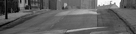


4 Examples for Surface Movements Crack and step formation due to underground coal mining Page 4

")
5 Examples for Surface Movements Collapse of an abandoned mine shaft (Wattenscheider Loch) Page 5
6 Examples for Surface Movements Development of wetlands by changes in ground water table Page 6
7 Examples for Surface Movements Collapse as consequence of leaching process above salt caverns Page 7


8 Examples for Surface Movements Collapse due to karst cavities Page 8
9 German Regulations Mining (similar in other European countries) Federal States Mining Authorities are responsible for any mining permission by German Mining Law Collateral clauses are ruling the mandatory surface monitoring in each single case considering the statutory regulations about mine surveying (especially accuracy classes) Mining companies have to present an adequate monitoring concept to fulfill these regulations Responsible mine surveying experts of the Mining Authorities have to evaluate the monitoring i concept for permission i Permission must be court-proof in case of any legal dispute Implementation of new, innovative monitoring methods requires a serious process of achieving the needed legal acceptance Page 9
10 Acceptance Process for Radarinterferometry in Germany - Status Valid German Mining Law makes it difficult for Mine Surveying Inspectors to accept monitoring concepts with radarinterferometry Description of accuracy is not possible as requested by law Evidence of accuracy, reliability and repeatability of results is required However, due to serious events some State Mining Authorities starts with first projects using radarinterferometry with in last 12 months e.g. Mining Authority of Nordrhein-Westfalen is project partner in TERRAFIRMA German Mine Surveyors Association is starting an initiative on development of Guidelines for the use of radarinterferometry for monitoring purposes in mining Ad-hoc working group (Head: N. Benecke) will start on March 22 nd, 2011 Similar guidelines are successfully in use for GNSS and laser scanning German/European Mining Authorities and Mining Industry is interested in dialogue with TERRAFIRMA about requirements and future operational services (GMES core services and specific project services) Page 10
11 Terrafirma Case Studies Mining Time Presentation Author Organisation Monday Session 2: Case Studies Mining, Part 1 16:20 Introduction to the Mining Theme Norbert Benecke DMT 16:50 Inactive/Abandoned Mines Ruhr The users perspective Heinz-Roland Neumann Bezirksregierung Arnsberg 17:20 Inactive/Abandoned Mines Ruhr Karsten Zimmermann DMT Tuesday Session 3: Case Studies Mining, Part 2 09:00 Stoke-on Trent Luke Bateson BGS 09:30 Gas Storage Berlin Friedrich Kühn BGR 10:00 Application of the Satellite Interferometry in the Upper Silesian Mining Basin Marek Graniczny, Zbigniew Kowalski PGI Page 11
12 Future of Terrafirma Geo-Hazard Information Services Session 4: The Future of the Terrafirma Geo-Hazard Information Services 11:15 Radarinterferometry and PostMining Database at the German Volker Spreckels RAG Deutsche Steinkohle Hardcoal Mining Company RAG AG 11:45 German Mining Law and use of radarinterferometry in mining Joachim Deutschmann Deutscher Markscheider Verein (DMV) 12:15 User requirements in Germany Jens Riecken Ministry of the Interior and a)the view in the German surveying administrations b)special needs and tasks in North-Rhine Westphalia Stephan Heitmann Local Affairs NRW 12:45 The future of Terrafirma - Wide Area Product Graint Cooksley / Nico Adam Altamira / DLR 13:15 Discussion and Conclusions Day 2 All participants (Chairman: N. Benecke) Page 12


13 Thank you for your attention! Glückauf Page 13
Spatial Information Management in the Context of Organizational Development the Approach in North-Rhine Westphalia, Germany
 Spatial Information Management in the Context of Organizational Development the Approach in North-Rhine Westphalia, Germany Dr. Jens Riecken DVW Vice President c/o Ministry of the Interior North-Rhine
GMES Terrafirma II Stassfurt Case Study - Preliminary Results -
 GMES Terrafirma II Stassfurt Case Study - Preliminary Results - Friedrich Kuehn BGR/Germany Email: friedrich.kuehn@bgr.de PSI-Processing by DLR Oberpfaffenhofen/Germany The Study Area: - The Stassfurt/Bernburg
Ready for INSPIRE.... connecting worlds. European SDI Service Center
 Ready for INSPIRE Consultancy SOFTWARE T r a i n i n g Solutions... connecting worlds European SDI Service Center Increasing Added Value with INSPIRE and SDI Components INSPIRE In 2007, the European Commission
GMES Terrafirma II Stassfurt Case Study - Preliminary Results -
 GMES Terrafirma II Stassfurt Case Study - Preliminary Results - Presenter: Kai Hahne Author: Friedrich Kuehn BGR/Germany Email: kai.hahne@bgr.de friedrich.kuehn@bgr.de PSI-Processing by DLR Oberpfaffenhofen/Germany
INSPIRE Coordination in Germany
 Inter-ministerial Committee for Geo Information INSPIRE Coordination in Germany The federal administrative level Pier-Giorgio Zaccheddu Head of Administration Office Inter-ministerial Committee for Geo
GEO-CRADLE Project Meeting 2 Thursday, 17 th November, 2016
 GEO-CRADLE Project Meeting 2 Thursday, 17 th November, 2016 T4.3 EGS-PGI NRI Marek Graniczny (EGS PGI) Maria Przyłucka (EGS PGI) Eleftheria Poyiadji (EGS-IGME-Greece) Zbigniew Kowalski (EGS PGI) Christodoulos
Plan4all (econtentplus project)
") Plan4all (econtentplus project) Karel CHARVAT 1, Tomáš MILDORF 2 1 Help service remote sensing, Ltd., Černoleská 1600, 256 01 Benešov u Prahy, Czech Republic charvat@bnhelp.cz 2 Department of Mathematics
Plan4all (econtentplus project) Karel CHARVAT 1, Tomáš MILDORF 2 1 Help service remote sensing, Ltd., Černoleská 1600, 256 01 Benešov u Prahy, Czech Republic charvat@bnhelp.cz 2 Department of Mathematics
OPEN GOVERNMENT - BENEFITS OF INSPIRE IN THE PUBLIC SECTOR
 Brussels, 04th March 2013 - Daniela Hogrebe and André Caffier from GDI-DE 1 OPEN GOVERNMENT - BENEFITS OF INSPIRE IN THE PUBLIC SECTOR Powered by INSPIRE Open Government 2 SDI is a fundament of transparent
German Remote Sensing Data Center (DFD) of DLR Department on Environment and Security. Training Course. Introduction to Geospatial Data Analysis
 of DLR Department on Environment and Security. Training Course. Introduction to Geospatial Data Analysis") Training Course Introduction to Geospatial Data Analysis 11-15 February 2008, NAM Center, Jakarta German Aerospace Center - DLR Information about the German Aerospace Center (DLR) DLR is Germany s national
Training Course Introduction to Geospatial Data Analysis 11-15 February 2008, NAM Center, Jakarta German Aerospace Center - DLR Information about the German Aerospace Center (DLR) DLR is Germany s national
Cooperating Country Report of GERMANY
 CCOP-47AS/4.1-19 COORDINATING COMMITTEE FOR GEOSCIENCE PROGRAMMES IN EAST AND SOUTHEAST ASIA (CCOP) 47 th CCOP Annual Session 17-21 October 2010 Manado, Indonesia Cooperating Country Report of GERMANY
TIM-online A part of the egovernment strategy by the Federal State North-Rhine Westphalia
 TIM-online A part of the egovernment strategy by the Federal State North-Rhine Westphalia Stefan Sandmann Surveying and mapping agency of North - Rhine Westphalia Muffendorfer Straße 19 21, D-53177 Bonn
IAEG SDGs WG GI, , Mexico City
 IAEG SDGs WG GI, 12-14.12.2016, Mexico City UN-GGIM:Europe s perspective and activities to support better integration of geospatial information and statistics and the UN SDG monitoring Pier-Giorgio Zaccheddu,
Venue of the Symposium Auditorium Gong, Lower Area of Vitkovice
 EUROCK 2017 report Number of registered participants: 245 Number of attended participants: 229 Date: June 19 24, 2017 (including workshops and technical visits) Venue: Auditorium GONG & Clarion Congress
Evaluating Sustainability of the Georesources Observation System
 Evaluating Sustainability of the Georesources Observation System Michael Mente Federal Institute for Geosciences and Natural Resources Germany, Hannover GEOSS-CBC Meeting Athens April 27th 28th, 2009 GEOSS-CBC
Underground Storage & Disposal - The Salt Concept. Thomas Brasser - GRS
 Underground Storage & Disposal - The Salt Concept Thomas Brasser - GRS Who is GRS ( Plant & Reactor Safety Ltd. ) Non-profit, independent expert and research organisation Assess and improve safety of technical
Land Cover and Asset Mapping Operational Change Detection
 Land Cover and Asset Mapping Operational Change Detection Andreas Müller DLR DFD with the support of Charly Kaufmann, Allan Nielsen, Juliane Huth ESA Oil & Gas Workshop, 13-14 September 2010 Folie 1 TWOPAC
German-Peruvian Workshop on Research Cooperation on Raw Materials of Strategic Economic Importance
 German-Peruvian Workshop on Research Cooperation on Raw Materials of Strategic Economic Importance Friday, 25 of September 2015 Sonesta Hotel El Olivar Research activities in the field of economical strategic
OVERALL PROGRAMME. Sunday 16 October 2016:
 Sunday 16 October 2016: OVERALL PROGRAMME - Arrival in Morocco (landing either in Casablanca, with transfers to hotel to be organized by EGS, or Rabat) - Hosted dinner for the European Geological Surveys,
SUBSIDENCE DETERMINATION BY DIFFERENT SENSOR TYPES USING STANDARDIZED TRANSFORMATION PARAMETERS
 SUBSIDENCE DETERMINATION BY DIFFERENT SENSOR TYPES USING STANDARDIZED TRANSFORMATION PARAMETERS Volker Spreckels Deutsche Steinkohle AG (DSK), Dept. DIG 2.2 Photogrammetry/Remote Sensing Tel.: ++49 2361
A COMPREHENSIVE ANALYSIS OF THE CAPABILITES AND LIMITATIONS OF PSI
 A COMPREHENSIVE ANALYSIS OF THE CAPABILITES AND LIMITATIONS OF PSI Rachel Holley, InSAR Surveying Consultant InSAR Surveying Team Fugro NPA Satellite Mapping Introduction Look at the capabilities and limitations
Economic and Social Council
 United Nations Economic and Social Council Distr.: General 18 July 2016 Original: English Committee of Experts on Global Geospatial Information Management Sixth session New York, 3-5 August 2016 Item 2
40 Years Listening to the Beat of the Earth
 EU-LA Mining & Exploration Convention Earth Observation in support of sustainable mining by the Geological Surveys of Europe Gerardo Herrera Veronika Kopačková Eleftheria Poyiadji Maria Przyłucka 40 Years
Mapping a Nation in 3D Singapore s Journey. Bryan Chew Registrar of Titles Assistant Chief Executive Singapore Land Authority
 Mapping a Nation in 3D Singapore s Journey Bryan Chew Registrar of Titles Assistant Chief Executive Singapore Land Authority Singapore Size - 719 sq km Population - 5.5 million Density 7,600/sq km Singapore
GMES-based Geoservices for Mining Areas
 GMES-based Geoservices for Mining Areas Dr. Andreas Müterthies EFTAS Fernerkundung GmbH Oststraße 2-18 48145 Münster Das Projekt wird unterstützt aus Mitteln der EU und des Landes Nordrhein-Westfalen This
Die Deutsche Rohstoffagentur (German Mineral Resources Agency) - Background and Concept -
 - Background and Concept -") Die Deutsche Rohstoffagentur (German Mineral Resources Agency) - Background and Concept - Dr. Hildegard Wilken Head of Sub-Department Economic Geology of Mineral Resources Federal Institute for Geosciences
Die Deutsche Rohstoffagentur (German Mineral Resources Agency) - Background and Concept - Dr. Hildegard Wilken Head of Sub-Department Economic Geology of Mineral Resources Federal Institute for Geosciences
State of Israel Ministry of Housing and Construction Survey of Israel. The Hydrological project case
 State of Israel Ministry of Housing and Construction Survey of Israel The Hydrological project case Survey of Israel Content Introduction To the Survey of Israel The operation assumptions The main responsibilities
APPLICABILITY OF PSINSAR FOR BUILDING HAZARD IDENTIFICATION
 APPLICABILITY OF PSINSAR FOR BUILDING HAZARD IDENTIFICATION. STUDY OF THE 29 JANUARY 2006 KATOWICE EXHIBITION HALL COLLAPSE AND THE 24 FEBRUARY 2006 MOSCOW BASMANNY MARKET COLLAPSE Zbigniew Perski (1),
The Swedish National Geodata Strategy and the Geodata Project
 The Swedish National Geodata Strategy and the Geodata Project Ewa Rannestig, Head of NSDI Co-ordination Unit, Lantmäteriet, ewa.rannstig@lm.se Ulf Sandgren, Project Manager Geodata Project, Lantmäteriet,
NGIAs' roles in successful disaster response
 The Second UN-GGIM-AP Plenary Meeting NGIAs' roles in successful disaster response Japan Teheran Iran 28 October 2013 Shin-ichi SAKABE, Director of International Affairs Division Geospatial Information
Earth Sciences Research Centre Potsdam Telegrafenberg Potsdam, Germany
 Earth Sciences Research Centre Potsdam Telegrafenberg 14473 Potsdam, Germany Research on Levee Failure in the Framework of the German Research Network Natural Disasters www.dfnk.de First IMPACT Workshop
Geodesy. orientation. shape. gravity field
 Geodesy noun Science of measuring the shape, orientation and gravity field of the Earth and how it changes over time. shape orientation gravity field Positioning has always been important Downstream applications
SWEDISH SDI DEVELOPMENT & IMPLEMENTATION OF INSPIRE
 SWEDISH SDI DEVELOPMENT & IMPLEMENTATION OF INSPIRE Christina Wasström, Lantmäteriet, 801 82 Gävle, Sweden, christina.wasstrom@lm.se ABSTRACT The Swedish Government and Parliament has given Lantmäteriet
What is Geopark? Geopark? YES.
 What is Geopark? NO Geopark? YES What is Geopark? The Geopark is an area where earth s history is experienced How do landscapes originate? What rocks and raw materials are found there? How does geology
A/AC.105/C.1/2016/CRP.17
 19 February 2016 English only Committee on the Peaceful Uses of Outer Space Scientific and Technical Subcommittee Fifty-third session Vienna, 15-26 February 2016 Item 11 of the provisional agenda Space
Geoinformation as a basis for the sustainable use of the subsurface. (Northern Germany)
") Geoinformation as a basis for the sustainable use of the subsurface An approach from Lower Saxony (Northern Germany) Jörg Elbracht, Hans Joachim Heineke & Udo Müller Geologic Survey of Lower Saxony Dep.
Geoinformation as a basis for the sustainable use of the subsurface An approach from Lower Saxony (Northern Germany) Jörg Elbracht, Hans Joachim Heineke & Udo Müller Geologic Survey of Lower Saxony Dep.
Compliance with occupational limit values by applying workplace measurements
 Occupational Limit Values for Hazardous Substances - Healthy working conditions in a global economy Conference under the German Presidency of the European Council, Dortmund, Germany, 7-8 May 2007 Compliance
EO Information Services in support of Satellite Tools for Building Flood Defence Systems in Guyana
 EO Information Services in support of Satellite Tools for Building Flood Defence Systems in Guyana F. N. Koudogbo and A. Arnaud Altamira Information J. Leen, Eurosense World Bank HQ, Washington DC Date
Ministry of ICT of I.R.IRAN
 The ECO 8/6 mill km 2 10 Slamic countries ~330 mill people Oil, Gas, Industries,Tourism 2 Issue transformation in last decade Problem solving needs more integrated approach More interaction &complexity
GEOLOGICAL HAZARD MITIGATION STRATEGY IN INDONESIA
 GEOLOGICAL HAZARD MITIGATION STRATEGY IN INDONESIA Surono Head of Geological Agency presented in: The 2nd Global Summit of Research Institutes for Disaster Risk Reduction Kihada Hall, Uji Campus, Kyoto
Global Monitoring of Changes in the Rock Mass Arising as a Result of Filling the Mining Workings with Wastes.
 Global Monitoring of Changes in the Rock Mass Arising as a Result of Filling the Mining Workings with Krzysztof PIETRUSZKA, Poland Key words: rock mass deformations, FEM modeling, geoinformatics SUMMARY
BIM and INSPIRE, for a better integration of built infrastructures in their environment : the MINnD project
 BIM and INSPIRE, for a better integration of built infrastructures in their environment : the MINnD project François ROBIDA Christophe CASTAING Strasbourg, > 1 8 septembre 2017 ABOUT BIM Building Information
CAWa Central Asian Water. Training Course Geographical Information Systems in Hydrology
 CAWa Central Asian Water Training Course Geographical Information Systems in Hydrology 1 Place & Time Place to hold the workshop: Helmholtz Centre Potsdam GFZ German Research Center for Geosciences, Germany
Feasibility Study: GEOSCIENTIFIC KNOWLEDGE AND SKILLS OF AFRICAN GEOLOGICAL SURVEYS. WP 3 - Gap analysis of geoscientific mapping
 Feasibility Study: GEOSCIENTIFIC KNOWLEDGE AND SKILLS OF AFRICAN GEOLOGICAL SURVEYS WP 3 - Gap analysis of geoscientific mapping Acquisition of metadata to geological maps as base for the compilation of
reviewed paper EU-Project: Cross-border Spatial Information System with High Added Value (CROSS-SIS) Stefan SANDMANN
 Stefan SANDMANN") reviewed paper EU-Project: Cross-border Spatial Information System with High Added Value (CROSS-SIS) Stefan SANDMANN Surveying and Mapping Agency NRW, Bonn, Muffendorfer Str. 19-21, Germany, sandman@lverma.nrw.de
reviewed paper EU-Project: Cross-border Spatial Information System with High Added Value (CROSS-SIS) Stefan SANDMANN Surveying and Mapping Agency NRW, Bonn, Muffendorfer Str. 19-21, Germany, sandman@lverma.nrw.de
Utilization of Global Map for Societal Benefit Areas
 Utilization of Global Map for Societal Benefit Areas The Fourth GEOSS AP Symposium Bali Indonesia, 11th March 2010 Shuhei Kojima Geographical Survey Institute Ministry of Land, Infrastructure, Transport
Use of geo-referenced data for DRM in Central Asia, problems and prospective
 Use of geo-referenced data for DRM in Central Asia, problems and prospective Dr. Akylbek Chymyrov Director, Kyrgyz Center of Geoinformation Systems Member of the Public Supervisory Board MES KR KSUCTA,
Polish Geological Institute National Research. Tasks, people and equipment
 Polish Geological Institute National Research Institute Tasks, people and equipment Warsaw, 08.07.2013 Established in the year 1919 The PGI-NRI is a research institute supervised by the Minister of the
Georeferencing and Satellite Image Support: Lessons learned, Challenges and Opportunities
 Georeferencing and Satellite Image Support: Lessons learned, Challenges and Opportunities Shirish Ravan shirish.ravan@unoosa.org UN-SPIDER United Nations Office for Outer Space Affairs (UNOOSA) UN-SPIDER
econtentplus GS Soil
 econtentplus GS Soil General aims Assessment and strategic development of INSPIRE compliant Geodata-Services for European Soil Data BPN on basis of the EU 2007/2/EC (INSPIRE) Directive for Annex III theme
European Spatial Data Research. EuroSDR. Prof. Dr. Ir. Joep Crompvoets. General Assembly CLGE Tirana 18 March
 EuroSDR Prof. Dr. Ir. Joep Crompvoets General Assembly CLGE - 2016 Tirana 18 March 2016 INTRODUCTORY QUESTIONS Who knows what is EuroSDR? Who does NOT know what is EuroSDR? Who is employed at mapping agencies?
UN Resolution on GGRF ( and its implementation in Europe)
") Presented at the FIG Working Week 2017, UN Resolution on GGRF ( and its implementation in Europe) May 29 - June 2, 2017 in Helsinki, Finland Markku Poutanen, FGI Contents Global Geodetic Reference Frame
Presented at the FIG Working Week 2017, UN Resolution on GGRF ( and its implementation in Europe) May 29 - June 2, 2017 in Helsinki, Finland Markku Poutanen, FGI Contents Global Geodetic Reference Frame
Czech ARC Node Bartosz Dąbrowski. ALMA Regional Centre, Czech Republic
 Bartosz Dąbrowski ALMA Regional Centre, Republic Toruń, 22 23 October 2013 The interface between ALMA and the astronomy community is provided by the three ALMA Regional Centres (ARCs), in Europe, North
GEOL 0086 Environmental Geology
 GEOL 0086 Environmental Geology Instructor: Dr. Carrie Davis Todd E-mail address: Phone: Office: Krebs 244 Office hours: Monday 3 4 pm; Tuesday 1 2 pm; Wednesday 9 10 am; or by appointment Textbook: Geology
Report on the establishment of UN GGIM: Europe Item 14. 4th session of the Committee of Experts on UN-GGIM
 Report on the establishment of UN GGIM: Europe Item 14 1 Why regional European committees of UN GGIM? In the ECOSOC resolution 2011/24 on the UN GGIM: Emphasizes the importance of promoting national, regional
Engineering Geology at University Complutense of Madrid: 30 years of postgraduate courses
 FIRST INTERNATIONAL CONFERENCE on EDUCATION and TRAINING in GEO-ENGINEERING ENGINEERING SCIENCES Constantza, Romania - June 2008 Engineering Geology at University Complutense of Madrid: 30 years of postgraduate
D.N.D. Hettiarachchi (Hetti) Survey Department, Sri Lanka.
 Survey Department, Sri Lanka.") ADMINISTRATION OF GEOGRAPHICAL NAMES IN SRI LANKA D.N.D. Hettiarachchi (Hetti) Survey Department, Sri Lanka. hettiarachchidnd@gmail.com Country: Sri Lanka What is the official language(s)? Sinhala and
ADMINISTRATION OF GEOGRAPHICAL NAMES IN SRI LANKA D.N.D. Hettiarachchi (Hetti) Survey Department, Sri Lanka. hettiarachchidnd@gmail.com Country: Sri Lanka What is the official language(s)? Sinhala and
Status of implementation of the INSPIRE Directive 2016 Country Fiches. COUNTRY FICHE Czech Republic
 Status of implementation of the INSPIRE Directive 2016 Country Fiches COUNTRY FICHE Czech Republic Introduction... 1 1. State of Play... 2 1.1 Coordination... 2 1.2 Functioning and coordination of the
ESA GMES: Terrafirma S3: Service Prospectus V4.4 June 2013 GMES TERRAFIRMA. ESRIN/Contract no / 05 / I-EC. S3: Service Prospectus
 GMES TERRAFIRMA ESRIN/Contract no. 19366 / 05 / I-EC S3: Service Prospectus Version 4.4 June 14 th 2013 Geraint Cooksley, Chris Bremmer, Salvatore Stramondo & Gaia Righini Reviewed by: Project Manager
NCAVES - Global initiative and national pilots
 NCAVES - Global initiative and national pilots Kavita Sharma UN Environment Pretoria, March 2018 Outline 1. Global initiative > Introduction > Objectives and deliverables >Activities in 2017 and 2018 2.
Continuous Risk Assessment of Structures and Plants in Areas of Ground Deformation Susceptibility by Space-based SAR/ASAR Interferometry
 CCN4 Project Continuous Risk Assessment of Structures and Plants in Areas of Ground Deformation Susceptibility by Space-based SAR/ASAR Interferometry Issaak Parcharidis*, Michael Foumelis and Penelope
Subsidence is the sinking or collapse of a portion of the land surface. The movement involved in subsidence is essentially vertical; little or no
 1 Subsidence is the sinking or collapse of a portion of the land surface. The movement involved in subsidence is essentially vertical; little or no horizontal motion is involved. It may take the form of
Optimizing work processes by using GIS in the ASFINAG. Peter Aubrecht ASFINAG Service GmbH, AUSTRIA EUC Croatia, Split 15 th October 2014
 Optimizing work processes by using GIS in the ASFINAG Peter Aubrecht ASFINAG Service GmbH, AUSTRIA EUC Croatia, Split 15 th October 2014 AGENDA The ASFINAG Group: Organisation and Tasks The ASFINAG Road
Interaction between wind turbines and the radar systems operated by the meteorological services
 Interaction between wind turbines and the radar systems operated by the meteorological services Challenges facing the DWD Carmen Diesner, Measurement Technology Division (TI 22), Deutscher Wetterdienst,
SLOPE PROCESSES, LANDSLIDES, AND SUBSIDENCE
 CHAPTER 9 SLOPE PROCESSES, LANDSLIDES, AND SUBSIDENCE La Conchita slide January 10, 2005 Triggered by heavy rainfall, reactivation along an older landslide surface (35,000 years ago, 6000 years ago, and
Vulnerability and Adaptation to Climate Change
 Vulnerability and Adaptation to Climate Change Prof. Dr. Christoph Görg Department of Social Sciences, University of Kasssel Head of Department Environmental Politics, UFZ Leipzig 1 Introduction: Climate
THE 3-REGIONS WORKING GROUP SLOPE INSTABILITIES (SlopeIn)
") Bayerisches Landesamt für Umwelt THE 3-REGIONS WORKING GROUP SLOPE INSTABILITIES (SlopeIn) COMMON LANGUAGE, COMPARABLE HAZARD MAPPING AND SHARED EXPERIENCES ACROSS EUROPE The 3-Regions Working-Group SlopeIn:
Bayerisches Landesamt für Umwelt THE 3-REGIONS WORKING GROUP SLOPE INSTABILITIES (SlopeIn) COMMON LANGUAGE, COMPARABLE HAZARD MAPPING AND SHARED EXPERIENCES ACROSS EUROPE The 3-Regions Working-Group SlopeIn:
National Geospatial Platforms Solution to interoperability challenge in Europe. Antti Jakobsson Programme manager National Land Survey of Finland
 National Geospatial Platforms Solution to interoperability challenge in Europe Antti Jakobsson Programme manager National Land Survey of Finland 1 Questionnaire made in 2017: Google search: Public Geospatial
Copernicus for Raw Materials Workshop
 Copernicus for Raw Materials Workshop Copernicus 40 User Years Forum Listening Industry Workshop, to the Beat 5th September of the Earth 2016, Brussels About http://copernicus.eu/raw-materials-workshop
Status of implementation of the INSPIRE Directive 2016 Country Fiches. COUNTRY FICHE Netherlands
 Status of implementation of the INSPIRE Directive 2016 Country Fiches COUNTRY FICHE Netherlands Introduction... 1 1. State of Play... 2 1.1 Coordination... 2 1.2 Functioning and coordination of the infrastructure...
UN GGIM and National SDI Strategy
 MSDI Open Forum on 26 th January 2016 Contributing to the successful delivery of MSDI UN GGIM and National SDI Strategy Hiroshi Murakami Deputy Administrator Geospatial Information Authority of Japan Geospatial
Working Group 1. Geodetic Reference Frame. Activity Report. for. The UN-GGIM-AP Plenary Meeting
 Regional Committee of United Nations Global Geospatial Information Management for Asia and the Pacific (UN-GGIM-AP) Established by a United Nations Resolution Working Group 1 Geodetic Reference Frame Activity
Application of ECGS to host the direction of the
 Président d honneur: Son Altesse Royale Le Grand Duc Henri Président Secrétaire J-M. Goerens E. Buttini ECGS 19, Rue Josy Welter L-7256 Walferdange http://www.ecgs.lu To the International Association of
IN POLAND. Adam WÓJCICKI. National Research Institute
 CO2 GEOLOGICAL STORAGE POTENTIAL IN POLAND Adam WÓJCICKI Polish Geological Institute National Research Institute Warsaw, June 2009 CO2 geological sequestration (definitions) Carbon capture and storage
Information System for Large Projects in Underground Space Development
 Information System for Large Projects in Underground Space Development Prof. Dr.-Ing. Monika Jarosch University of Siegen, Germany Prof. Dr.-Ing. O.K. Postolskaya Prof. Dr.-Ing. S. Yufin Dipl.-Ing. A.V.
GEOHART CONSULTANTS Geotechnical (Mining & Civil)
") Wouter Hartman Principal Geotechnical Engineer / Director Geotechnical Engineering in Brown Coal 21 st April 2014 Outline Setting the Scene Geo-Technical Mechanism of Failure Historical Failures Known
Wouter Hartman Principal Geotechnical Engineer / Director Geotechnical Engineering in Brown Coal 21 st April 2014 Outline Setting the Scene Geo-Technical Mechanism of Failure Historical Failures Known
UPDATE ON HYDROCARBON LAW AND PROJECTIONS OF SHALE GAS RESOURCES
 UPDATE ON HYDROCARBON LAW AND PROJECTIONS OF SHALE GAS RESOURCES Marta Wagrodzka Department of Geology and Geological Concessions April 24 th, 2013 American-Polish Energy Roundtable Primary energy demand
INSPIRing effort. Peter Parslow Ordnance Survey December Various European approaches to managing an SDI
 INSPIRing effort Peter Parslow Ordnance Survey December 2015 Various European approaches to managing an SDI WHAT IS INSPIRE? A European Union Directive A community effort: http://inspire.ec.europa.eu/
SAR interferometry Status and future directions. Rüdiger Gens
 SAR interferometry Status and future directions Rüdiger Gens Polarimetric InSAR Polarimetric InSAR InSAR - Status and future directions sensitivity to changes in surface scattering, even in the presence
Land Administration and Cadastre
 Geomatics play a major role in hydropower, land and water resources and other infrastructure projects. Lahmeyer International s (LI) worldwide projects require a wide range of approaches to the integration
EU GeoCapacity. Assessing European Capacity for Geological Storage of Carbon Dioxide. Thomas Vangkilde-Pedersen, GEUS
 EU GeoCapacity Assessing European Capacity for Geological Storage of Carbon Dioxide Thomas Vangkilde-Pedersen, GEUS GeoCapacity results and the future for geological storage of CO 2 EU GeoCapacity open
Background Document: Report of the Regional Committee of United Nations Global Geospatial Information Management for Asia and the Pacific
 Background Document: Report of the Regional Committee of United Nations Global Geospatial Information Management for Asia and the Pacific 1. Summary 1. This report highlights the activities carried out
Disaster Information System of Alpine Regions. DIS-ALP powered by Means of the European Regional Development Fund (ERDF)
") DIS-ALP Disaster Information System of Alpine Regions DIS-ALP powered by Means of the European Regional Development Fund (ERDF) DIS-ALP Disaster InformationSystem of Alpine Regions General Information
DIS-ALP Disaster Information System of Alpine Regions DIS-ALP powered by Means of the European Regional Development Fund (ERDF) DIS-ALP Disaster InformationSystem of Alpine Regions General Information
INSPIRE - A Legal framework for environmental and land administration data in Europe
 INSPIRE - A Legal framework for environmental and land administration data in Europe Dr. Markus Seifert Bavarian Administration for Surveying and Cadastre Head of the SDI Office Bavaria Delegate of Germany
Terrafirma Extension Tectonic Theme. 6 th Terrafirma Workshop ESA-ESRIN, December 1st, 2010
 Terrafirma Extension Tectonic Theme 6 th Terrafirma Workshop ESA-ESRIN, December 1st, 2010 Summary - Service Prospectus Presentation - The Terrafirma Extension Tectonic Theme (TFX-TT) - Greek Task Force
European Severe Weather
 European Severe Weather Management & Communications Paul Arnold National Weather Strategy Specialist Network Rail U.K. Introduction U.K. - The 2009/10 winter was the 3 rd coldest in the last 50 years and
From SARA (Germany)*) (= Satellitengestütztes Raummonitoring) to SASMO**) (=Satellite based spatial monitoring for Europe)
*) (= Satellitengestütztes Raummonitoring) to SASMO**) (=Satellite based spatial monitoring for Europe)") From SARA (Germany)*) (= Satellitengestütztes Raummonitoring) to SASMO**) (=Satellite based spatial monitoring for Europe) *) This cooperative project, funded by the Brandenburg Ministry for Economic Affairswas
From SARA (Germany)*) (= Satellitengestütztes Raummonitoring) to SASMO**) (=Satellite based spatial monitoring for Europe) *) This cooperative project, funded by the Brandenburg Ministry for Economic Affairswas
The Global Geodetic Observing System (GGOS) of the International Association of Geodesy (IAG)
 of the International Association of Geodesy (IAG)") The Global Geodetic Observing System (GGOS) of the International Association of Geodesy (IAG) Hermann Drewes Representative of the International Union of Geodesy and Geophysics (IUGG) to the Cartographic
The Global Geodetic Observing System (GGOS) of the International Association of Geodesy (IAG) Hermann Drewes Representative of the International Union of Geodesy and Geophysics (IUGG) to the Cartographic
GEOVEKST A Norwegian Program for Cost Sharing in Production, Updating and Administration of Geographic Data
 GEOVEKST A Norwegian Program for Cost Sharing in Production, Updating and Administration of Dr. Anne Kirsten S. HØSTMARK, Norway Key words: Mapping in large scale, formal co-operation, cost sharing, standarised
9/13/2011 CHAPTER 9 AND SUBSIDENCE. Case History: La Conchita Landslide. Introduction
 CHAPTER 9 SLOPE PROCESSES, LANDSLIDES, AND SUBSIDENCE Case History: La Conchita Landslide La Conchita: small coastal community 80 km (50 mi) northwest of Los Angeles Landslide occurred on January 10, 2005
Creating A-16 Compliant National Data Theme for Cultural Resources
 Creating A-16 Compliant National Data Theme for Cultural Resources Cultural Resource GIS Facility National Park Service John J. Knoerl Deidre McCarthy Paper 169 Abstract OMB Circular A-16 defines a set
CORS911: REAL-TIME SUBSIDENCE MONITORING OF THE NAPOLEONVILLE SALT DOME SINKHOLE USING GPS
 CORS911: REAL-TIME SUBSIDENCE MONITORING OF THE NAPOLEONVILLE SALT DOME SINKHOLE USING GPS LSU Center for GeoInformatics Joshua D. Kent & Larry E. Dunaway 29 th Annual Louisiana Remote Sensing & GIS Workshop
The Global Statistical Geospatial Framework and the Global Fundamental Geospatial Themes
 The Global Statistical Geospatial Framework and the Global Fundamental Geospatial Themes Sub-regional workshop on integration of administrative data, big data and geospatial information for the compilation
Disaster Management in Republic of Korea
 The Third UN-GGIM-AP Plenary Meeting Disaster Management in Republic of Korea ~Coordination among NGIA & Other Related Organizations and Recommendations~ Bali Indonesia 10 November 2014 Sanghoon Lee, Ph.D.
Pilot applications for Egypt related end-users
 GEO-CRADLE Regional Workshop Thursday, 25 th May, 2017 Pilot applications for Egypt related end-users Hesham El-Askary Chapman University Panagiotis Kosmopoulos National Observatory of Athens Stelios Kazadzis
THE FEASIBILITY AND APPLICATION OF PSI TO DETECT A RANGE OF GROUND AND STRUCTURE MOTION PHENOMENA.
 THE FEASIBILITY AND APPLICATION OF PSI TO DETECT A RANGE OF GROUND AND STRUCTURE MOTION PHENOMENA. Rachel Holley, InSAR Surveying Consultant InSAR Surveying Team Fugro NPA Satellite Mapping Introduction
Near Surface Geophysics
 Near Surface Geophysics The Geological Society Careers Day, Nottingham 2017 Tim Grossey CGeol Director Geophysics, RSK Geosciences Copyright of RSK 24 November 2017 1 What is Geophysics? Earth science
The PREVIEW project: general objectives and an overview of the landslides platform
 The PREVIEW project: general objectives and an overview of the landslides platform Risk Mitigation for Earthquakes and Landslides Giacomo Falorni Earth Sciences Dept. University of Firenze 19-20 July 2007
Status of implementation of the INSPIRE Directive 2016 Country Fiches. COUNTRY FICHE Estonia
 Status of implementation of the INSPIRE Directive 2016 Country Fiches COUNTRY FICHE Estonia Introduction... 1 1. State of Play... 2 1.1 Coordination... 2 1.2 Functioning and coordination of the infrastructure...
INTEGRATED HEAVY RAIN RISK MANAGEMENT
 INTEGRATED HEAVY RAIN RISK MANAGEMENT Newsletter #1 June 2017 November 2017 RAINMAN finally started 2 What do we plan to do 3 Kick-off meeting in Vienna 5 Scoping workshop on risk assessment and mapping
Launch of the ESPON 2013 Programme. European observation network on territorial development and cohesion
 Launch of the ESPON 2013 Programme European observation network on territorial development and cohesion Framework conditions for the ESPON 2013 Programme Policy development in use of territorial evidence