Beckenanalyse 2. Genetische stratigraphische Konzepte
|
|
|
- Maurice Smith
- 6 years ago
- Views:
Transcription
1 Beckenanalyse 2. Genetische stratigraphische Konzepte Einsele 2000 CYCLIC BEDDING Einsele


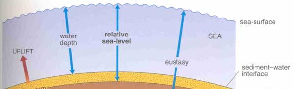
2 Sequenzstratigraphie Das Konzept der Sequenzstratigraphie beruht auf dem Zusammenspiel von Sedimentzufuhr und Akkomodationsraum, letzterer wird gesteuert über eustatische Meeresspiegelschwankungen und Subsidenz bzw. Hebung (Raten!). sedimentary response to perturbations of the equilibrium profile caused by uplift / subsidence and/or sea level change 2


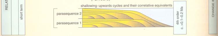
3 The simplest way to understand sequence stratigraphy is to consider the interface area between coastal and shallow-marine siliciclastic depositional environments where changes in relative sea level are easiest to interpret. The parasequence forms the smallest and simplest unit in the framework of sequence stratigraphy. It results from a small-amplitude, short-term oszillation in the balance between sediment supply and accomodation space. Example: coastal environment: 3

4 4
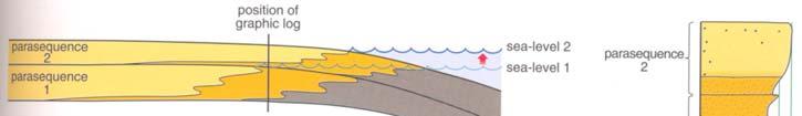
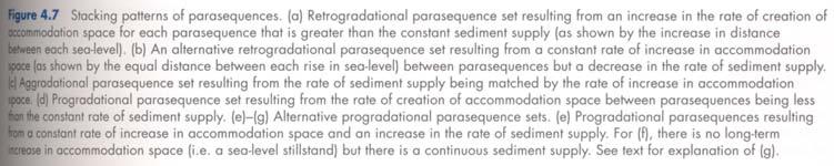
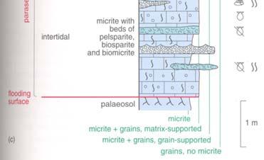
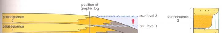
5 Parasequence Sets 5


6 Parasequence Sets forced regression Sequences and System Tracts A sequence or depositional sequence is composed of a succession of parasequence sets. Each sequence represents one cycle of change in the balance between accomodation space and sediment supply. Sequences generally range in thickness from a few meter to tens or even hundreds of m, and they are the next larger (or longer duration) cycles above parasequences. Similar to parasequences, sequences are the result of changes in eustatic sea-level and/or subsidence/uplift resulting in a changing relative sea-level ( accomodation space, see below), and/or changes in sediment supply. eustatic sea level + subsidence relative sea-level 6

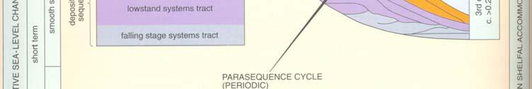
 - Falling Stage Systems Tract (FSST) - Lowstand Systems Tract (LST) - Transgressive Systems Tract (TST) The high number of different")
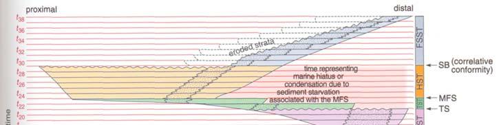
7 relative sea-level curves Fig. 4.8b: blue curve taken from Fig. 4.8a; purple curve combines blue curve with short-term changes in accomodation space associated with the development of parasequences. Every sequence is composed of up to four systems tracts, each of which represents a specific part in the cyclic change in the balance between accomodation space and sediment supply. Each systems tract is made up of at least one parasequence set. Different conditions may result in one or more of the systems tracts not being developed or preserved. The four systems tracts are: - Highstand Systems Tract (HST) - Falling Stage Systems Tract (FSST) - Lowstand Systems Tract (LST) - Transgressive Systems Tract (TST) The high number of different factors involved in any one geological situation (such as climate, eustatic sea-level change, subsidence rate, sediment supply, lithology,...) means that the resultant sequences are highly variable. However, every sequence has similar genetic components related to changes in the rate of accomodation space creation and sediment supply. Because the geometry of the basin floor is crucial to the evolution of depositional sequences and systems tracts, we will consider in the following to principal types of depositional profiles from the land to the sea: shelf-break margin ramp margin 7


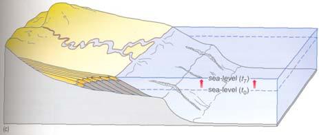
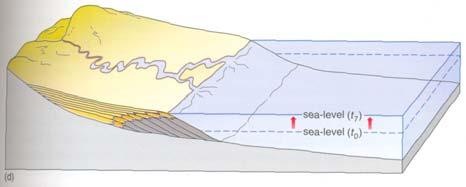
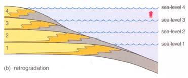
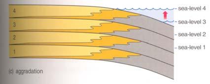
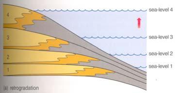
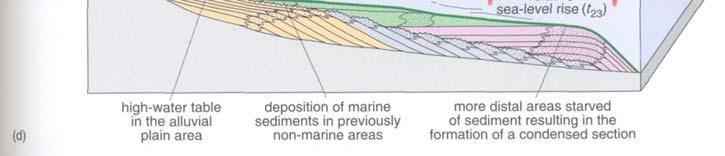
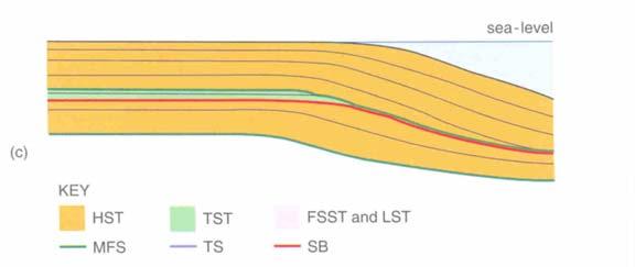
8 The Highstand Systems Tract (HST) shelf-break margin (c) (d) ramp margin 8


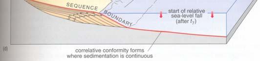
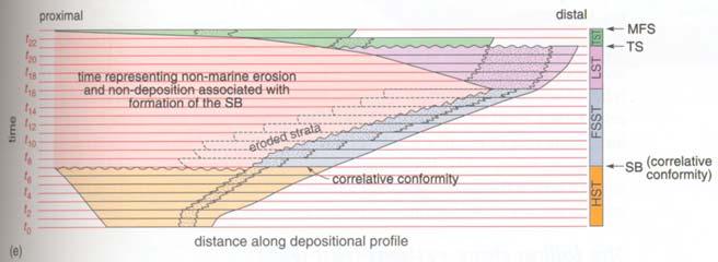
9 Sequence Boundary (SB) Coe et al ramp margin 9


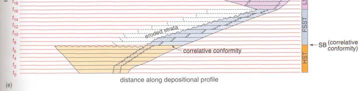
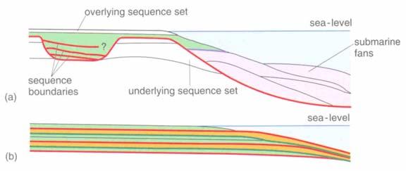
10 The Falling Stage Systems Tract (FSST) shelf-break margin (c) submarine fans deposited at base of continental slope (d) ramp margin 10


 decreasing")


11 Different geometries of Falling Stage Systems Tracts on ramp type margins increasing rate of relative sea-level fall or (and) decreasing rate of sediment supply old young Loss of accomodation space caused by relative sea-level fall A + B << B C + D D 11


 (c)")
12 The Lowstand Systems Tract (LST) ramp margin (d) (c) shelf-break margin 12
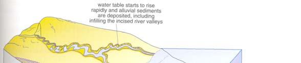
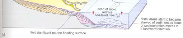
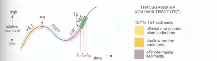
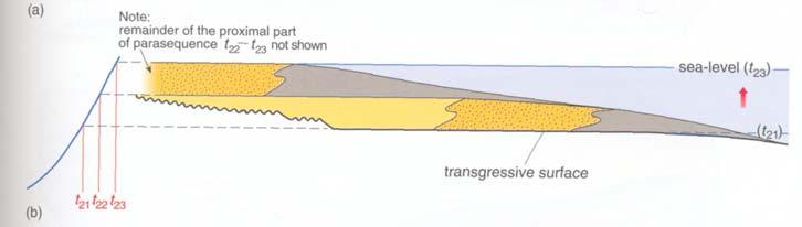
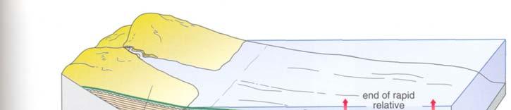
13 Transgressive Surface (TS) The Transgressive Systems Tract (TST) (a) 13
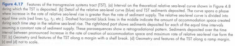
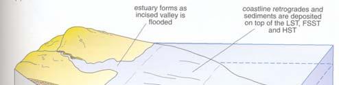
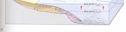
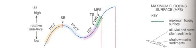
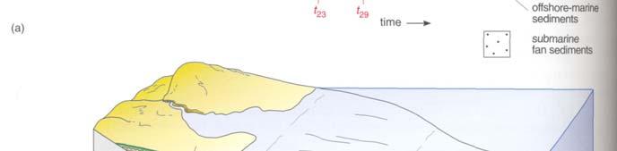
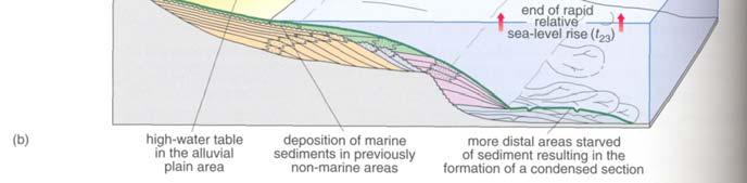
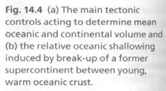
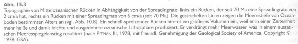
14 shelf-break margin (c) (d) ramp margin Maximum FloodingSurface (MFS) 14
15 15
16 Beckenanalyse 3. Meeresspiegelschwankungen global vs. local / regional Einsele

17 Mesozoic sea-level change Reading 1996 Chronostratigraphic chart and sea-level curve for the Jurassic (Haq et al. 1988) Reading
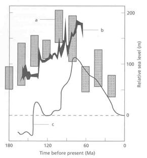
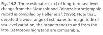
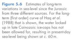
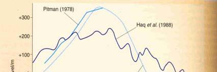
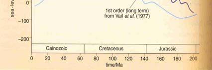
18 Chronostratigraphic chart and sea-level curve for the Cretaceous (Haq et al. 1988) Reading 1996 Different estimates of long-term Mesozoic sea-level changes Leeder


19 How to measure sea-level change? coastal maps coastal sediments tidal gauge oxygen isotopes 19


")
20 Late Pliocene to Recent oxygen isotopic cycles Holocene (b) Leeder 1999 LGM 20


21 The hierarchy of stratigraphical cycles next slide The hierarchy of stratigraphical cycles 21


22 Bahlburg & Breitkreuz 1998 Processes controlling relative sea-level and sediment supply 22
23 Processes controlling eustatic sea-level change Reading 1996 Bahlburg & Breitkreuz 1998 Leeder


24 Break-up of Pangea and associated increase in sea-floor spreading Einsele 2000 The three orbital parameters that cause orbital cyclicity ( Milankovich Cycles ) 24
 Orbital")


 sum of the")


25 Fig (a) Orbital parameters of the sun-moon-earth system and their temporal variation during the last 800 ka. (b) sum of the signals shown in (a) in terms of energy received by the outer atmosphere. Einsele 2000 time [Ma] greenhouse vs. icehouse 25

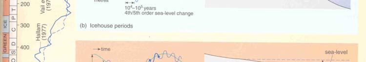
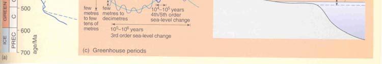
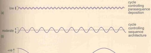
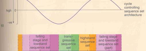
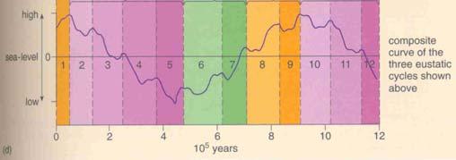
26 Multiple order sea-level fluctuations 26
27 27


28 Principal factors influencing sequence development (from Galloway 1989) Beckenanalyse 4. Sediment Supply / Sediment Budget Denudation: average amount of lowering of the land surface in a certain region due to weathering and erosion Fig c General trends in climaticallycontrolled production of clastic sediments and the input of dissolved constituents into sedimentary basins. Ca Einsele


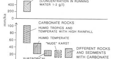
29 Einsele 2000 Chemical denudation vs rock type Einsele

 (b) 30")
30 Denudation vs Exhumation Leeder 1999 (a) (b) Leeder


")

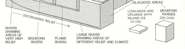
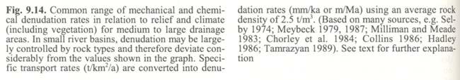
31 sediment yield vs drainage area specific sediment yield SY (t/km 2 /a) Einsele 2000 Einsele
 size and denudation")
 biogenic sediment production in the basin itself (4) tectonic and total subsidence of basin floor as well as")
 relative sea-level or base level changes and their frequencies and amplitudes.")
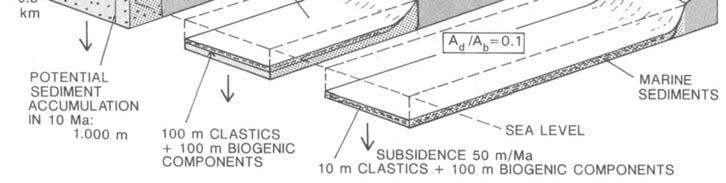
32 modern vs long-term denudation rates Einsele 2000 Basin Fill the filling of sedimentary basins and the architecture and facies associations of their sediments are generally controlled by the interaction between several more or less independent factors: (1) size and denudation characteristics of land areas delivering terrigenous sediments (specific sediment yield) (2) areal extent and geometry of the corresponding basin receiving sediment (3) biogenic sediment production in the basin itself (4) tectonic and total subsidence of basin floor as well as compaction of sediments (5) distribution of the sediment in relation to the hydraulic regime of the water-filled basin, or, on land, of the river system crossing and feeding the basin with sediments. (6) relative sea-level or base level changes and their frequencies and amplitudes. (Einsele 2000) 32


![thickness per unit time [m/ma]) Fig. 10.3.](/docs-images/73/69414339/images/33-3.jpg "Overview of sedimentation rates in various")

33 Sediment budget denudation rate vs sedimentation rate Fig a Qualitative model showing the influence of size and relief of denudation area on sediment fill of neighbouring basins. Einsele 2000 sedimentation rate (sediment thickness per unit time [m/ma]) Fig Overview of sedimentation rates in various depositional environments which are dominated either by allochthonous, siliciclastic sediments, or autochthonous, biogenic materials Einsele


34 long-term vs short-term sedimentation rates Einsele 2000 suspended dissolved loads solids Einsele


35 F D VS VS Einsele 2000 Einsele

36 Einsele
h m h a + ρ c h c + ρ a + ρ m
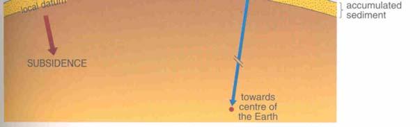
 Beckenanalyse 1. Subsidenz Hohe Sediment-Akkumulation und die Bildung Sedimentärer Becken sind nicht möglich ohne entsprechenden Subsidenz. Subsidenz beschreibt die Senkung der Erdoberfläche (Landoberfläche
Depositional Sequences Sequences
 Depositional Sequences Transgressive and Regressive packages can be bound by unconformities Because sediment can only be preserved during net aggradation and progradation All other times there is either
Sedimentary Basins. Gerhard Einsele. Springer-Verlag Berlin Heidelberg New York London Paris Tokyo Hong Kong Barcelona Budapest
 Gerhard Einsele Sedimentary Basins Evolution, Facies, and Sediment Budget With 269 Figures Springer-Verlag Berlin Heidelberg New York London Paris Tokyo Hong Kong Barcelona Budapest Contents Part I Types
Sequence Stratigraphy as a tool for water resources management in alluvial coastal aquifers: application to the Llobregat delta (Barcelona, Spain)
") Sequence Stratigraphy as a tool for water resources management in alluvial coastal aquifers: application to the Llobregat delta (Barcelona, Spain) Desiré Gàmez Torrent December 2007 CHAPTER 1: Introduction
Sequence Stratigraphy as a tool for water resources management in alluvial coastal aquifers: application to the Llobregat delta (Barcelona, Spain) Desiré Gàmez Torrent December 2007 CHAPTER 1: Introduction
4.1 Sediment accommodation space principles and controls
 58 The sedimentary record of sea-level change 4. Sediment accommodation space principles and controls Sequence stratigraphy emphasizes the importance of the space that is made available within a basin
Introduction to sequence stratigraphy and its application to reservoir geology
 Introduction to sequence stratigraphy and its application to reservoir geology Massimo Zecchin Istituto Nazionale di Oceanografia e di Geofisica Sperimentale - OGS Historical development Definitions Systems
Sequence Stratigraphy. Historical Perspective
 Sequence Stratigraphy Historical Perspective Sequence Stratigraphy Sequence Stratigraphy is the subdivision of sedimentary basin fills into genetic packages bounded by unconformities and their correlative
SEQUENCE STRATIGRAPHY
 SEQUENCE STRATIGRAPHY Course of Stratigraphy G301 Second semester (February-June2014) Department of Geology College of Science/University of Basrah Instructor:Dr. Nawrast S. Abd Alwahab Lecture 4 & 5 1
Sequence Stratigraphy: An Applied Workshop
 Sequence Stratigraphy: An Applied Workshop Instructor: Prof. Octavian Catuneanu Level: Intermediate Duration: 5 days Course Description and Objectives This workshop presents the concepts and practical
GY 402: Sedimentary Petrology
 UNIVERSITY OF SOUTH ALABAMA GY 402: Sedimentary Petrology Lecture 28: Student Choice Lecture 1: Sequence Stratigraphy Instructor: Dr. Douglas W. Haywick Today Sequence Stratigraphy The basic concept (systems
A Simplified Guide For Sequence Stratigraphy:
 SEPM Society for Sedimentary Geology A Simplified Guide For Sequence Stratigraphy: Nomenclature, Definitions and Method Vitor Abreu President - SEPM Abstract All attempts to codify Sequence Stratigraphy
Last Time. Submarine Canyons and Fans. Turbidites. MAS 603: Geological Oceanography. Lecture 16: Greenhouse vs. Icehouse Earths
 UNIVERSITY OF SOUTH ALABAMA Last Time MAS 603: Geological Oceanography Lecture 16: Greenhouse vs. Icehouse Earths Submarine Fans Definition and morphology Transport mechanisms (density currents) Submarine
Sediment and Sedimentary rock
 Sediment and Sedimentary rock Sediment: An accumulation of loose mineral grains, such as boulders, pebbles, sand, silt or mud, which are not cemented together. Mechanical and chemical weathering produces
Accommodation. Tectonics (local to regional) Subsidence Uplift
 Subsidence Uplift") Accommodation Accommodation varies over time; it is the distance between a reference horizon and the sea surface (i.e. relative sea level). The space to be filled in with sediments or water What are the
Accommodation Accommodation varies over time; it is the distance between a reference horizon and the sea surface (i.e. relative sea level). The space to be filled in with sediments or water What are the
The Geology of Stratigraphic Sequences
 The Geology of Stratigraphic Sequences Bearbeitet von Andrew Miall 2nd ed. 2010. Buch. xvii, 522 S. Hardcover ISBN 978 3 642 05026 8 Format (B x L): 19,5 x 26 cm Gewicht: 1337 g Weitere Fachgebiete > Geologie,
Source- to- Sink in the Stra/graphic Record
 Source- to- Sink in the Stra/graphic Record Capturing the Long-Term, Deep-Time Evolution of Sedimentary Systems Stephan A. Graham Stanford University Brian W. Romans Chevron Energy Technology Co. Jacob
Controls on clastic systems in the Angoche basin, Mozambique: tectonics, contourites and petroleum systems
 P2-2-13 Controls on clastic systems in the Angoche basin, Mozambique: tectonics, contourites and petroleum systems Eva Hollebeek, Olivia Osicki, Duplo Kornpihl Schlumberger, London, UK Introduction Offshore
Seismic interpretation. Principles of seismic stratigraphic interpretation
 Seismic interpretation Principles of seismic stratigraphic interpretation Seismic interpretation Seismic stratigraphy is a technical for interpreting stratigraphic information from seismic data. The resolution
Seismic stratigraphy, some examples from Indian Ocean, interpretation of reflection data in interactive mode
 Seismic stratigraphy, some examples from Indian Ocean, interpretation of reflection data in interactive mode K. S. Krishna National Institute of Oceanography, Dona Paula, Goa-403 004. krishna@nio.org Seismic
EARTH SURFACE PROCESSES AND SEDIMENTATION!
 Sed and Strat EARTH SURFACE PROCESSES AND SEDIMENTATION! 2/27 Lecture 7- Exposure: Weathering and the Sediment Factory 3/04 Lecture 8 - Rivers and Landscapes 3/06 Lecture 9 - Waves (not Tides) 3/11 Lecture
Quantitative Tarfaya Basin Development, Morocco*
 Quantitative Tarfaya Basin Development, Morocco* Axel Wenke 1, Rainer Zühlke 1, Haddou Jabour 2, Oliver Kluth 3, and Torge Schümann 3 Search and Discovery Article #10420 (2012)** Posted July 16, 2012 *Adapted
Seismic interpretation of carbonate turbidites in Central Luconia
 GeoL. Soc. MaLayaia, BuLLetin 47, December 2005; pp. 77-85 Seismic interpretation of carbonate turbidites in Central Luconia FRANcis Ho, GUENTER JAEGER AND PmT LAMBREGTS Sarawak Shell Berhad SMEP Exploration
Temporal significance of sequence boundaries
 ELSEVIER Sedimentary Geology 121 (1998) 157 178 Temporal significance of sequence boundaries Octavian Catuneanu a,ł, Andrew J. Willis b, Andrew D. Miall c a Department of Geology, Rhodes University, Grahamstown
Case Study of the Structural and Depositional-Evolution Interpretation from Seismic Data*
 Case Study of the Structural and Depositional-Evolution Interpretation from Seismic Data* Yun Ling 1, Xiangyu Guo 1, Jixiang Lin 1, and Desheng Sun 1 Search and Discovery Article #20143 (2012) Posted April
Sequence stratigraphy and basin analysis of the Meso- to Cenozoic Tarfaya- Laayoune Basins, on- and offshore Morocco
 Sequence stratigraphy and basin analysis of the Meso- to Cenozoic Tarfaya- Laayoune Basins, on- and offshore Morocco INAUGURAL-DISSERTATION zur Erlangung der Doktorwtirde der Naturwissenschaftlich-Mathematischen
Sedimentation on passive margins. Master1 Géologie de l Exploration et des Réservoirs Dynamique des Bassins Michel Séranne
 Sedimentation on passive margins 1 Tectonic-sedimentation relationships at passive margin scale rift Break-up Young margin Sedimentation is controled by continental margin geodynamic evolution Mature margin
Marine Science and Oceanography
 Marine Science and Oceanography Marine geology- study of the ocean floor Physical oceanography- study of waves, currents, and tides Marine biology study of nature and distribution of marine organisms Chemical
Aptian/Albian Reservoir Development in the Jeanne d Arc Basin, Offshore Eastern Canada
 Aptian/Albian Reservoir Development in the Jeanne d Arc Basin, Offshore Eastern Canada Jonathan Marshall, Statoil Canada Ltd. Calgary, Alberta, Canada. jomars@statoil.com Introduction: The Jeanne d Arc
Quiz 12 Bonus 2 (9:30-9:35 AM)
") Quiz 12 Bonus 2 (9:30-9:35 AM) UNIVERSITY OF SOUTH ALABAMA GY 112: Earth History Lectures 32 and 33: Mesozoic Sedimentation Instructor: Dr. Douglas W. Haywick Last Time Mesozoic Tectonics A) The Triassic
Quiz 12 Bonus 2 (9:30-9:35 AM) UNIVERSITY OF SOUTH ALABAMA GY 112: Earth History Lectures 32 and 33: Mesozoic Sedimentation Instructor: Dr. Douglas W. Haywick Last Time Mesozoic Tectonics A) The Triassic
Sedimentary Rocks. Origin, Properties and Identification. Physical Geology GEOL 100. Ray Rector - Instructor
 Sedimentary Rocks Origin, Properties and Identification Physical Geology GEOL 100 Ray Rector - Instructor Sedimentary Rock Origin and Identification Lab Pre-Lab Internet Link Resources 1) http://www.rockhounds.com/rockshop/rockkey/index.html
Reading Material. See class website. Sediments, from Oceanography M.G. Gross, Prentice-Hall
 Reading Material See class website Sediments, from Oceanography M.G. Gross, Prentice-Hall Materials filling ocean basins Dissolved chemicals especially from rivers and mid-ocean ridges (volcanic eruptions)
Understanding Earth Fifth Edition
 Understanding Earth Fifth Edition Grotzinger Jordan Press Siever Chapter 5: SEDIMENTATION: Rocks Formed by Surface Processes Lecturer: H Mohammadzadeh Assistant professors, Department of Geology, FUM Copyright
Rockall Plateau. OCN 201: Shelf Sediments
 Rockall Plateau OCN 201: Shelf Sediments Classification by Size Classification by Mode of Formation Detrital sediments Transported and deposited as particles Derived from weathering of pre-existing rocks
Master1 Réservoirs Géologiques Architecture des Bassins - Michel Séranne
 1 Tectonic-sedimentation relationships at passive margin scale Outward drainage Bordering Alluvial fans rift Axial Lake (restricted => Preserved OM) Transgressive seq.(evaporites) Sedimentation is controled
Chapter 4: Sequence Stratigraphy of the Cherokee Group
 Chapter 4: Sequence Stratigraphy of the Cherokee Group 4.1 Sequence Stratigraphic Nomenclature Sequence stratigraphic concepts provide a framework to better explain and predict the lateral distribution,
QUATERNARY GEOLOGICAL MAP OF THE CONTINENTAL SHELF OF VIETNAM AT THE SCALE OF 1:1,000,000
 VNU. JOURNAL OF SCIENCE, Earth sciences, T.xxIII, N 0 1, 2007 QUATERNARY GEOLOGICAL MAP OF THE CONTINENTAL SHELF OF VIETNAM AT THE SCALE OF 1:1,000,000 Tran Nghi, Dinh Xuan Thanh, Nguyen Thanh Lan, Tran
EDIMENTARY BASINS. What is a Sedimentary Basin? by Prof. Dr. Abbas Mansour
 EDIMENTARY BASINS What is a Sedimentary Basin? by Prof. Dr. Abbas Mansour WHAT IS A SEDIMENTARY BASIN? A low area on the Earth s surface relative to surroundings e.g. deep ocean basin (5-10 km deep) e.g.
Lab 7: Sedimentary Structures
 Name: Lab 7: Sedimentary Structures Sedimentary rocks account for a negligibly small fraction of Earth s mass, yet they are commonly encountered because the processes that form them are ubiquitous in the
SEQUENCE STRATIGRAPHY OF THE COAL BEARING OTTNANGIAN (?) - KARPATHIAN SEDIMENT SERIES IN THE EAST BORSOD BASIN (N-HUNGARY)
 - KARPATHIAN SEDIMENT SERIES IN THE EAST BORSOD BASIN (N-HUNGARY)") SEQUENCE STRATIGRAPHY OF THE COAL BEARING OTTNANGIAN (?) - KARPATHIAN SEDIMENT SERIES IN THE EAST BORSOD BASIN (N-HUNGARY) Z. PÜSPÖKI, M. KOZÁK, L. VINCZE and R. MCINTOSH University of Debrecen, Department
SEQUENCE STRATIGRAPHY OF THE COAL BEARING OTTNANGIAN (?) - KARPATHIAN SEDIMENT SERIES IN THE EAST BORSOD BASIN (N-HUNGARY) Z. PÜSPÖKI, M. KOZÁK, L. VINCZE and R. MCINTOSH University of Debrecen, Department
Sedimentary Rocks. Origin, Properties and Identification. Geology Laboratory GEOL 101 Lab Ray Rector - Instructor
 Sedimentary Rocks Origin, Properties and Identification Geology Laboratory GEOL 101 Lab Ray Rector - Instructor Sedimentary Rock Origin and Identification Lab Pre-Lab Internet Link Resources 1) http://www.rockhounds.com/rockshop/rockkey/index.html
Sequence Stratigraphic Analysis of Mixed, Reefal Carbonate and Siliciclastic Systems. Ashton Embry. Geological Survey of Canada.
 Sequence Stratigraphic Analysis of Mixed, Reefal Carbonate and Siliciclastic Systems Ashton Embry Geological Survey of Canada Outline Sequence Stratigraphy Sequence Surfaces and Sequence Boundaries for
14.2 Ocean Floor Features Mapping the Ocean Floor
 14.2 Ocean Floor Features Mapping the Ocean Floor The ocean floor regions are the continental margins, the ocean basin floor, and the mid-ocean ridge. 14.2 Ocean Floor Features Continental Margins A continental
Surface Processes Focus on Mass Wasting (Chapter 10)
") Surface Processes Focus on Mass Wasting (Chapter 10) 1. What is the distinction between weathering, mass wasting, and erosion? 2. What is the controlling force in mass wasting? What force provides resistance?
Surface Processes Focus on Mass Wasting (Chapter 10) 1. What is the distinction between weathering, mass wasting, and erosion? 2. What is the controlling force in mass wasting? What force provides resistance?
Accommodation- vs. supply-dominated systems for sediment partitioning to deep water. Supplementary documents
 GSA Data Repository 2019145 1 2 Accommodation- vs. supply-dominated systems for sediment partitioning to deep water Supplementary documents 3 4 5 6 Jinyu Zhang 1, Wonsuck Kim 1, Cornel Olariu 1,2, Ronald
Building an Idealized Stra0graphic Sequence Clas0c Shoreline Example William W. Li?le
 Building an Idealized Stra0graphic Sequence Clas0c Shoreline Example William W. Li?le Purpose: The purpose of this exercise is to guide students through the process of construc0ng a stra0graphic sequence
Stratigraphic Trap Identification Based on Restoration of Paleogeophology and Further Division of System Tract: A Case Study in Qingshui Subsag*
 Stratigraphic Trap Identification Based on Restoration of Paleogeophology and Further Division of System Tract: A Case Study in Qingshui Subsag* Cao Laisheng 1, Yu Lin 1, Liu Jianlun 1, Xiang Sheng 1,
ES120 Sedimentology/Stratigraphy
 Midterm Exam 5/05/08 NAME: 1. List or describe 3 physical processes that contribute to the weathering of rocks (3pts). exfoliation frost wedging many others. roots, thermal expansion/contraction also credit
Chapter 4 Implications of paleoceanography and paleoclimate
 Age ka / Chapter 4 Implications of paleoceanography and paleoclimate 4.1 Paleoclimate expression 4.2 Implications of paleocirculation and tectonics 4.3 Paleoenvironmental reconstruction MD05-2901 (Liu
In 1990, 50% of the U.S. population lived within 75 km of a coast. By 2010, 75% of the U.S. population will live within 75 km of a coast.
 In 1990, 50% of the U.S. population lived within 75 km of a coast. By 2010, 75% of the U.S. population will live within 75 km of a coast. High Tech Methods for Surveying the Deep Sea Floor Fig. 20.18 1
Sedimentary Rocks. Origin, Properties and Identification. Physical Geology GEOL 101 Lab Ray Rector - Instructor
 Sedimentary Rocks Origin, Properties and Identification Physical Geology GEOL 101 Lab Ray Rector - Instructor Sedimentary Rock Origin and Identification Lab Pre-Lab Internet Link Resources 1) http://www.rockhounds.com/rockshop/rockkey/index.html
Bulletin of Earth Sciences of Thailand
 Depositional Environments and Stratigraphic Development of the Grand Taman Sari Circuit Outcrop: an Analogue for Transgressive Mahakam Delta Successions Ridha Santika Riadi Petroleum Geoscience Program,
Depositional Environments. Depositional Environments
 Depositional Environments Geographic area in which sediment is deposited Characterized by a combination of geological process & environmental conditions Depositional Environments Geological processes:
v Hypothesis: The uplift of the Tibetan Plateau is an active driver for global cooling of the Cenozoic period By Roslyn Gober 11 February 2015
 Objective Uplift of Tibetan Plateau as Active Driver for Cenozoic Climate Change v Use Paleoarchives from the Tibetan Plateau to support the uplift weathering hypothesis for global cooling over the last
Stratigraphy. Sequence, Seismic & Integrated Stratigraphic Analysis
 An Intensive 5 Day Training Course Stratigraphy Sequence, Seismic & Integrated Stratigraphic Analysis 11-15 Nov 2018, Dubai 09-OCT-17 This course is Designed, Developed, and will be Delivered under iso
SAMPLE QUESTIONS FOR GEOLOGY 103, TEST 1
 SAMPLE QUESTIONS FOR GEOLOGY 103, TEST 1 The correct answers are listed at the bottom (no peeking!). These questions are to give you an idea of the type of questions that will be asked. They are not a
Th P4 07 Seismic Sequence Stratigraphy Analysis Using Signal Mode Decomposition
 Th P4 07 Seismic Sequence Stratigraphy Analysis Using Signal Mode Decomposition F. Li (University of Olahoma), R. Zhai (University of Olahoma), K.J. Marfurt* (University of Olahoma) Summary Reflecting
Forward Modeling of Stratigraphic Sequences at Continental Margins
 Forward Modeling of Stratigraphic Sequences at Continental Margins Michael S. Steckler Lamont-Doherty Earth Observatory of Columbia University Palisades, NY 10964-8000 phone: (914) 365-8479 fax: (914)
Mammoth Cave National Park, Kentucky
 Mammoth Cave National Park, Kentucky Objectives of Today s Lecture Refresher on Sedimentary Depositional Systems and Rock Classifications Transgressive and Regressive Marine Environments Carbonate Depositional
Journal of Earth Sciences and Geotechnical Engineering, vol. 4, no. 1, 2014, ISSN: (print), (online) Scienpress Ltd, 2014
, (online) Scienpress Ltd, 2014") Journal of Earth Sciences and Geotechnical Engineering, vol. 4, no. 1, 2014, 17-24 ISSN: 1792-9040 (print), 1792-9660 (online) Scienpress Ltd, 2014 Reconstruction of Relative Tectonic Movements Using Transgressive
Journal of Earth Sciences and Geotechnical Engineering, vol. 4, no. 1, 2014, 17-24 ISSN: 1792-9040 (print), 1792-9660 (online) Scienpress Ltd, 2014 Reconstruction of Relative Tectonic Movements Using Transgressive
2011 SEG SEG San Antonio 2011 Annual Meeting 1134
 Seismic Stratigraphic Interpretation from a Geological Model A North Sea Case Study Sébastien Lacaze* and Fabien Pauget, Eliis, Michel Lopez and Aurélien Gay, University of Montpellier II, Marion Mangue,
Transgressive-Regressive (T-R) Sequence Stratigraphy
 Sequence Stratigraphy") Transgressive-Regressive (T-R) Sequence Stratigraphy Embry, Ashton F. Geological Survey of Canada Calgary, Alberta, Canada, T2L 2A7 e-mail: aembry@nrcan.gc.ca Abstract A sequence, as originally defined
Transgressive-Regressive (T-R) Sequence Stratigraphy Embry, Ashton F. Geological Survey of Canada Calgary, Alberta, Canada, T2L 2A7 e-mail: aembry@nrcan.gc.ca Abstract A sequence, as originally defined
Ocean Basins, Bathymetry and Sea Levels
 Ocean Basins, Bathymetry and Sea Levels Chapter 4 Please read chapter 5: sediments for next class and start chapter 6 on seawater for Thursday Basic concepts in Chapter 4 Bathymetry the measurement of
PLATEAU UPLIFT, EPEIROGENEY AND CLIMATE CHANGES The KALAHARI PLATEAU, a world class laboratory
 PLATEAU UPLIFT, EPEIROGENEY AND CLIMATE CHANGES The KALAHARI PLATEAU, a world class laboratory F. Guillocheau M. De Wit G. Dubois B. Linol F. Eckardt W. Cotterill D. Rouby C. Robin Géosciences-Rennes Université
Backstripping sediments progressively through geological time.
 Backstripping sediments progressively through geological time. The purpose of backstripping is to use the stratigraphic record to quantitatively estimate the depth that basement would be in the absence
Erlangga Septama 1 and Samuel J. Bentley 1. Search and Discovery Article #50283 (2010) Posted August 10, 2010
 Posted August 10, 2010") Late Quaternary Deepwater Fan Depositional Cycles in the Gulf of Papua: Linking Sources, Dynamic Sedimentation Processes, and Depositional Architecture* Erlangga Septama 1 and Samuel J. Bentley 1 Search
Late Quaternary Deepwater Fan Depositional Cycles in the Gulf of Papua: Linking Sources, Dynamic Sedimentation Processes, and Depositional Architecture* Erlangga Septama 1 and Samuel J. Bentley 1 Search
MARINE GEOLOGY & GEOGRAPHY
 MARINE GEOLOGY MARINE GEOLOGY & GEOGRAPHY Marine Geology 4 LAYERS OF THE EARTH CRUST THICKNESS: VARIES BETWEEN OCEAN & CONTINENTS 5-40 KM STATE: SOLID ELEMENTS: SILICON, ALUMINUM, CALCIUM, SODIUM, POTASSIUM
Sequence Biostratigraphy and Depositional Modelling of the Pennsylvanian-Permian Belloy Formation Peace River Embayment, Alberta Canada
 Page No. 104-1 Sequence Biostratigraphy and Depositional Modelling of the Pennsylvanian-Permian Belloy Formation Peace River Embayment, Alberta Canada Lindsay A. Dunn* and Charles M. Henderson Applied
SEQUENCE STRATIGRAPHY OF THE LATE PALEOCENE-PLIO- PLEISTOCENE DEPOSITS, CENTRAL TARANAKI BASIN, NEW ZEALAND
 SEQUENCE STRATIGRAPHY OF THE LATE PALEOCENE-PLIO- PLEISTOCENE DEPOSITS, CENTRAL TARANAKI BASIN, NEW ZEALAND Abd Alsalam Almasgari 1, 2 and Umar Hamzah 1 1 Department of Geology, School of Environmental
Earth Systems Science Chapter 7. Earth Systems Science Chapter 7 11/11/2010. Seismology: study of earthquakes and related phenomena
 Earth Systems Science Chapter 7 I. Structure of the Earth II. Plate Tectonics The solid part of the earth system includes processes, just like the atmosphere and oceans. However, the time scales for processes
Down-stream process transition (f (q s ) = 1)
 = 1)") Down-stream process transition (f (q s ) = 1) Detachment Limited S d >> S t Transport Limited Channel Gradient (m/m) 10-1 Stochastic Variation { Detachment Limited Equilibrium Slope S d = k sd A -θ d S
Down-stream process transition (f (q s ) = 1) Detachment Limited S d >> S t Transport Limited Channel Gradient (m/m) 10-1 Stochastic Variation { Detachment Limited Equilibrium Slope S d = k sd A -θ d S
Continental Landscapes
 Continental Landscapes Landscape influenced by tectonics, climate & differential weathering Most landforms developed within the last 2 million years System moves toward an equilibrium Continental Landscapes
Earth History. What is the Earth s time scale? Geological time Scale. Pre-Cambrian. FOUR Eras
 The Earth is 4.6 billion years old! Earth History Mrs. Burkey ESS Cy Creek HS 17-18 If the Earth formed at midnight 6:00 am First life appears 10:00 pm First animals/plants on land 11:59 pm First humans
Biostratigraphic and Lithostratigraphic Correlation of Sedimentary Strata in the Atlantic Coastal Plain
 Biostratigraphic and Lithostratigraphic Correlation of Sedimentary Strata in the Atlantic Coastal Plain Introduction to the Atlantic Coastal Plain (Please read this page prior to doing the lab) The Atlantic
24. Ocean Basins p
 24. Ocean Basins p. 350-372 Background The majority of the planet is covered by ocean- about %. So the majority of the Earth s crust is. This crust is hidden from view beneath the water so it is not as
CHAPTER 7 Back into the Icehouse: The Last 55 Million Year. speaker: 林 烈
 CHAPTER 7 Back into the Icehouse: The Last 55 Million Year speaker: 林 烈 Global Climate Change Since 55 Myr Age Evidence from Ice & Vegetation Oxygen Isotope Data Why Did Globe Climate Cool over the Last
mountain rivers fixed channel boundaries (bedrock banks and bed) high transport capacity low storage input output
 high transport capacity low storage input output") mountain rivers fixed channel boundaries (bedrock banks and bed) high transport capacity low storage input output strong interaction between streams & hillslopes Sediment Budgets for Mountain Rivers Little
mountain rivers fixed channel boundaries (bedrock banks and bed) high transport capacity low storage input output strong interaction between streams & hillslopes Sediment Budgets for Mountain Rivers Little
Geology Test Review Answers
 Name: Geology Test Review Answers Core: Fill in the blanks: 1. Sediments get compacted and cemented into sedimentary rock. 2. Igneous rocks can be intrusive or extrusive from a volcano. 3. Adding heat
Evaporite basins with emphasis on the Permian Zechstein
 Evaporite basins with emphasis on the Permian Zechstein Kristin Börner Institute of Geology, University of Mining and Technology, Freiberg, Germany Abstract. This paper looks first at the distribution
Application of Predictive Modeling to the Lower Cretaceous Sedimentary Sequences of the Central Scotian Basin
 Application of Predictive Modeling to the Lower Cretaceous Sedimentary Sequences of the Central Scotian Basin Christopher R. Sangster 1, Nicolas Hawie 2, Georgia Pe-Piper 1, Francky Saint-Ange 2, David
GEOLOGY MEDIA SUITE Chapter 8
 UNDERSTANDING EARTH, SIXTH EDITION GROTZINGER JORDAN GEOLOGY MEDIA SUITE Chapter 8 Clocks in Rocks Timing the Geologic Record 2010 W.H. Freeman and Company Stratigraphy and fossils Figure 8.4 (page 172)
MARINE GEOLOGY & GEOGRAPHY
 MARINE GEOLOGY & GEOGRAPHY Bathymetry BATHYMETRY BATHYMETRY THE UNDERWATER EQUIVALENT TO TOPOGRAPHY THE STUDY OF WATER DEPTH A BATHYMETRIC MAP SHOWS FLOOR RELIEF OR TERRAIN AS CONTOUR LINES Bathymetry
Turbidites Characterization from Seismic Stratigraphy Analysis: Application to the Netherlands Offshore F3 Block*
 Turbidites Characterization from Seismic Stratigraphy Analysis: Application to the Netherlands Offshore F3 Block* E. Illidge 1, J. Camargo 1, and J. Pinto 1 Search and Discovery Article #41952 (2016)**
Geologic Trips San Francisco and the Bay Area
 Excerpt from Geologic Trips San Francisco and the Bay Area by Ted Konigsmark ISBN 0-9661316-4-9 GeoPress All rights reserved. No part of this book may be reproduced without written permission in writing,
OUTCROP! CHARACTERISATION! OF! TRANSGRESSIVE! SANDSTONE! RESERVOIRS:! QUANTITATIVE!COMPARISON!OF!OUTCROP!ANALOGUES!
 OUTCROP CHARACTERISATION OF TRANSGRESSIVE SANDSTONE RESERVOIRS: QUANTITATIVECOMPARISONOFOUTCROPANALOGUES OLIVER D. JORDAN 1, PETER J. SIXSMITH 2, GARY J. HAMPSON, SANJEEV GUPTA & HOWARDD.JOHNSON DepartmentofEarthScienceandEngineering,ImperialCollegeLondon,SouthKensington
RAYMOND SIEVER Harvard University
 E A R T H FOURTH EDITION FRANK PRESS National Academy of Sciences RAYMOND SIEVER Harvard University W. H. Freeman and Company New York Preface xiii Acknowledgments xviii PART I PROLOGUE CHAPTER 1 HISTORY
Lecture Outline Wednesday - Friday February 14-16, 2018
 Lecture Outline Wednesday - Friday February 14-16, 2018 Quiz 2 scheduled for Friday Feb 23 (Interlude B, Chapters 6,7) Questions? Chapter 6 Pages of the Past: Sedimentary Rocks Key Points for today Be
The surface of the ocean floor is as varied as the land. The five major oceans, from largest to smallest, are
 11.1 Ocean Basins The surface of the ocean floor is as varied as the land. The five major oceans, from largest to smallest, are w the Pacific w the Atlantic w the Indian w the Southern w the Arctic The
Unit 1: Water Systems on Earth Chapter 2
 Unit 1: Water Systems on Earth Chapter 2 Create a mind map with the driving question, Why are Oceans Important? Remember: Why are oceans so important? Why are oceans so important? Primary water source
Sedimentary Processes and Stratigraphic Responses in a Tectonically Driven Basin: Northern California Continental Shelf and Upper Slope
 Sedimentary Processes and Stratigraphic Responses in a Tectonically Driven Basin: Northern California Continental Shelf and Upper Slope LONG-TERM GOALS Craig S. Fulthorpe and James A. Austin, Jr. This
Global phosphorus cycle
 Global phosphorus cycle OCN 623 Chemical Oceanography 11 April 2013 2013 Arisa Okazaki and Kathleen Ruttenberg Outline 1. Introduction on global phosphorus (P) cycle 2. Terrestrial environment 3. Atmospheric
Clastic Sedimentary Rocks
 Clastic Sedimentary Rocks Alessandro Grippo, Ph.D. Alternating sandstones and mudstones in Miocene turbidites Camaggiore di Firenzuola, Firenze, Italy Alessandro Grippo review Mechanical weathering creates
Tony Pratt, DNREC to The Center for the Inland Bays Scientific and Technical Advisory Committee. August 21, 2009
 Sea Level Rise in Delaware Presented by Tony Pratt, DNREC to The Center for the Inland Bays Scientific and Technical Advisory Committee August 21, 2009 Sea level has been fluctuating ever since there have
Review participation point: The evidence for a fluid outer core is:
 DDA1 Continental Drift to Plate Tectonics PS 100 Chapter 28 Review participation point: The evidence for a fluid outer core is: A. Average density of the earth is greater than the density of the crust.
Unit 2: Geodetic survey of stratigraphic section Student exercise
 Unit 2: Geodetic survey of stratigraphic section Student exercise Assignment design by Bruce Douglas (Indiana University) and Chris Crosby (UNAVCO). Contextualization by Katherine Shervais (UNAVCO). One
Foundations of Earth Science, 6e Lutgens, Tarbuck, & Tasa
 Foundations of Earth Science, 6e Lutgens, Tarbuck, & Tasa Oceans: The Last Frontier Foundations, 6e - Chapter 9 Stan Hatfield Southwestern Illinois College The vast world ocean Earth is often referred
Chapter 3 Sedimentation of clay minerals
 Chapter 3 Sedimentation of clay minerals 3.1 Clay sedimentation on land 3.2 From land to sea 3.3 Clay sedimentation in the sea 1 3.1 Clay sedimentation on land Deserts Glaciers Rivers Lacustrine 2 University
Lecture 1: Scope, assessment and structure of course; Introduction to Sedimentology and Basic Definitions: uses and applications of Sedimentology.
 GEOL 440 Sedimentology and stratigraphy: processes, environments and deposits Jim Best MWF: Lectures and F: Laboratory Class Bruce Fouke Lecture 1: Scope, assessment and structure of course; Introduction
Instantaneous Spectral Analysis Applied to Reservoir Imaging and Producibility Characterization
 Instantaneous Spectral Analysis Applied to Reservoir Imaging and Producibility Characterization Feng Shen 1* and Gary C. Robinson 1, Tao jiang 2 1 EP Tech, Centennial, CO, 80112, 2 PetroChina Oil Company,
MISSISSIPPI RIVER DELTA OVERVIEW
 MISSISSIPPI RIVER DELTA OVERVIEW Science and Engineering Special Team Conference Louisiana State University October 9, 2012 Introduction Basics of the Mississippi Delta Natural and Human-Induced Land Loss
1/31/2013. Weathering Includes Physical, Chemical, Biological processes. Weathering Mechanisms. Wind abrasion forming Ventifacts
 Monument Valley, Utah. What weathering processes contributed to the development of these remarkable rock formations? Weathering Includes Physical, Chemical, Biological processes Weathering Mechanisms Physical