Accommodation. Tectonics (local to regional) Subsidence Uplift
|
|
|
- Ezra Heath
- 5 years ago
- Views:
Transcription

1 Accommodation Accommodation varies over time; it is the distance between a reference horizon and the sea surface (i.e. relative sea level). The space to be filled in with sediments or water What are the primary controls? Eustasy change in global sea level due to: Global tectonics (e.g., mid-ocean rift crustal volume) Climate (e.g., seawater locked up in polar ice caps during glacial times and released during interglacial times) Climate (e.g., thermal expansion of ocean due to warming) Tectonics (local to regional) Subsidence Uplift
2 Variations in Accommodation and Sediment Supply Sediment supply Sedimentary basin (accommodation) the two most important controls in the filling of a basin are accommodation and supply. The patterns of basin fills can be understood by considering how accommodation and supply change over space and time.
 uplift")

3 Variations in Accommodation: Tectonic subsidence and Uplift Sediment supply Sedimentary basin (accommodation) uplift Wheeler (1964) As we zoom in, base level can vary by location and is dynamic w/r/t tectonic and depositional history. subsidence


4 Variations in Accommodation: Tectonic subsidence and Uplift Patzkowsky and Holland 2012

5 What is base-level? Base level represents the surface that uplands want to erode down to and the surface that basins want to fill up to Sea level is the best example of base level, but it is not synonymous with base level
 are trying to achieve and preserve an equilibrium profile (depositional profile)")
6 How do we measure Accommodation Space? At all times sedimentary basins (systems) are trying to achieve and preserve an equilibrium profile (depositional profile) Where the available accommodation space is balanced by the amount of sediment supplied
7 Topographical profile of the height of the source area and the increase in the rate of discharge downstream
8 Uplift will cause the rivers to cut down (incise) and sediment removed

9 Subsidence of the source area will change the shape of the profile and the river system will re-adjust by eroding and depositing sediment to regain stable profile

10 Change in sea level will alter the equilibrium profile A rise in sea level the position of the coastline will change, river channels infill and gradient flattens out

11 Stratigraphy: Record of changes in Accommodation We know that undisturbed sediments form stacks with the oldest material at the base. These stacks, or stratigraphic columns, can be correlated over distances, because sediment deposition is laterally continuous.

12 Laterally continuous strata
13 How to extrapolate a stratigraphic section for facies analyses and depositional environment interpretation 20 m Let s say you go out to an outcrop and measure a section in which you document, thickness, lithology, grain size, sedimentary structures, biogenic structures, etc. simplified grain-size profile (in detail, there would be much more information depicted) You then interpret several different depositional environments based on these objective facies.


14 How to extrapolate a stratigraphic section for facies analyses and depositional environment interpretation 20 m 1 km You then measure another section laterally some distance away, within the same lithostratigraphic package, and also document the facies and interpret depositional environments.
15 How to extrapolate a stratigraphic section for facies analyses and depositional environment interpretation 20 m 1 km Over the next few weeks of field work, you map out the facies and measure several more sections in some locations, you can physically correlate surfaces that separate distinct facies (and, thus, environments).

16 Surfaces that separate distinct facies 20 m 1 km The combination of surfaces and depositional environment provides a framework to interpret the depositional history this is sequence stratigraphy

17 How would you define a depositional profile?
18 How would you define a depositional profile? A = floodplain of meandering river B = braided river C = estuarine mouth (e.g., barrier system) D = estuarine E = delta plain F = delta mouth bar and delta front G = prodelta For each surface-bounded package, always ask yourself: Which way is the shoreline?

19 SCENARIOS LEADING TO RELATIVE RISE IN SEA LEVEL
 http://sepmstrata.org/power-point-lectures/seq-strat-lectures.html")
20 SCENARIOS LEADING TO RELATIVE FALL IN SEA LEVEL Because we commonly only observe the resulting stratigraphic response, we refer to these changes as relative rise/fall of sea level. (With more information, you can then interpret if it was caused by eustasy, tectonics, or combination of both.)
21 THEORETICAL CURVE OF SEA LEVEL VARIATION PLUS SUBSIDENCE Short-term fluctuations in eustasy (absolute sea level) combined with longer-term increase in subsidence. Nichols (2009)
22 HIGH-FREQUENCY SEA-LEVEL CHANGES ON LONG-TERM CURVE Even higher-frequency sea-level fluctuations added how many orders of accommodation increase/decrease here? Nichols (2009)

23 THINKING ABOUT CORRELATION OF TIME-EQUIVALENT UNITS Three sections (subsurface wells, in this case) show the same upward-coarsening pattern interpreted as shoreface succession. 1 km Basinward 3 m HOW WOULD YOU CORRELATE THESE? from Steve Hubbard

24 THINKING ABOUT CORRELATION OF TIME-EQUIVALENT UNITS from Steve Hubbard One correlation option is to connect up the units of similar lithology. This would be a lithostratigraphic correlation. 1 km Basinward 3 m But, what does the vertical pattern of upward-coarsening, even in just one of the sections, suggest about the depositional stacking?
 it helps us reconstruct paleo-environments with greater accuracy and predict in areas of")
25 THINKING ABOUT CORRELATION OF TIME-EQUIVALENT UNITS from Steve Hubbard An alternative correlation would be to link up different facies that are timeequivalent. 1 km Basinward 3 m Although this is still a hypothesis to be tested (with more data) it helps us reconstruct paleo-environments with greater accuracy and predict in areas of limited data.
26 THINKING ABOUT CORRELATION OF TIME-EQUIVALENT UNITS An alternative correlation would be to link up different facies that are time-equivalent. 1 km Basinward 3 m Although this is still a hypothesis to be tested (with more data) it helps us reconstruct paleo-environments with greater accuracy and predict in areas of limited data. from Steve Hubbard
27 THINKING ABOUT CORRELATION OF TIME-EQUIVALENT UNITS from Steve Hubbard An alternative correlation would be to link up different facies that are time-equivalent. 1 km Basinward 3 m Although this is still a hypothesis to be tested (with more data, for example) it helps us reconstruct paleo-environments with greater accuracy.
28 ANOTHER EXAMPLE Lithostratigraphic correlation from Steve Hubbard
 correlation from Steve Hubbard")
29 ANOTHER EXAMPLE Chronostratigraphic (sequence stratigraphic) correlation from Steve Hubbard
30 PARASEQUENCES BUILDING BLOCKS OF SEQUENCES These packages of strata representing a consistently evolving depositional environment are called parasequences 1 km Basinward Parasequences come in different styles (depending on environment), but can be thought of as the building blocks of sequences. 3 m Characterizing how these building blocks stack helps us determine larger-scale/longer-term depositional evolution.

31 EXAMPLE OF TWO UPWARD-FINING PARASEQUENCES Parasequences are smaller-scale packages inside sequences. They come in different forms, it depends on the depositional environment. These are from clastic tide-dominated shoreline.

32 EXAMPLE OF A UPWARD-COARSENING SHOREFACE PARASEQUENCE Parasequences are smaller-scale packages inside sequences. They come in different forms, it depends on the depositional environment. This type should look familiar this is the classic coarsening-upward clastic shoreface cycle.
33 EXAMPLE OF A CARBONATE TIDAL FLAT PARASEQUENCE SHALLOWING-UP SUCCESSION figure drawn by J. Fred Read (Virginia Tech emeritus)
34 Outcrop example Progradational Stacking Gradual shallowing upwards Flooding surface Shallow carbonates overlain by offshore shales progressively get more carbonates as there is a net shallowing upward then flooded again and goes back to offshore shales
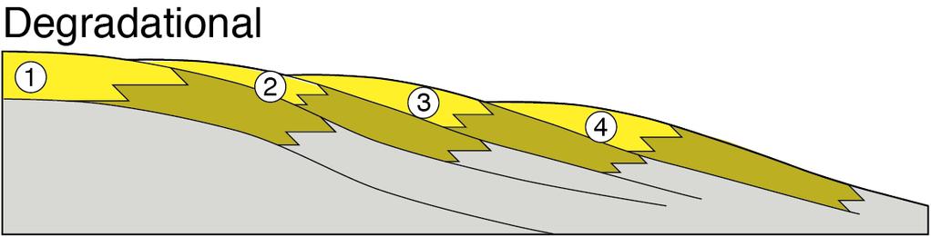
35 STACKING PATTERNS Arrangement of vertical successions (stacking patterns): Progradational basinward/seaward stepping Retrogradational landward stepping Aggradational builds vertically Degradational abrupt basinward shift in facies Parasequences are the building blocks that can stack in these systematic ways.


36 Set of five retrogradationally stacked parasequences in mixed carbonate and siliciclastic mudstone facies thickly bedded carbonates represent shallow subtidal facies, interbedded carbonates and mudstones were deposited in deep subtidal facies, and mudstone facies indicate offshore facies. Flooding Surfaces Mississippian Bangor Limestone along I-24, just southeast of Monteagle, Tennessee; Courtesy Steve Holland


37 Three parasequences developed along on a tidal flat. parasequences are shallowingupward Ordovician Juniata Formation near Germany Valley, West Virginia; Courtesy Steve Holland

38 Aggradational stacking with a flooding surface (shale)

39 offshore shales overlain by shallow carbonates progressively get more carbonates as there is a net shallowing upward trend Gradual shallowing upwards Flooding surface

40 offshore facies are muddy and characterized by the development of covered slopes Transition zone facies consist of interbedded mudstone and sandstone, whereas shoreface and foreshore facies consist only of sandstone. foreshore facies are commonly overlain by a coal, which bleaches the underlying foreshore to white, in contrast to the buff colors of the shoreface. overall coarsening upward from offshore facies near the bottom to shoreface and foreshore facies near the top. individual flooding surfaces can be recognized by reverals in this trend, they are not as well developed as in a retrogradational set of parasequences classic exposure of the Cretaceous Blackhawk Formation in Gentile Wash near Helper, Utah; Courtesy Steve Holland
41
42 MULTIPLE PARASEQUENCES STACK TO FORM LARGER-SCALE PATTERNS individual parasequence individual parasequence

43 ACCOMMODATION/SUPPLY RATIO AND STACKING PATTERNS A/S < 1 Sedimentation rate exceeds Accommodation rate A/S > 1 Accommodation rate exceeds sedimentation rate A/S = 1 Accommodation rate nearly equals sedimentation rate Degradational: Accommodation space is LOST

44 THE SEA COMES IN, THE SEA GOES OUT Remember the concept of onshore-to-offshore facies Recall the concepts of facies and Walther s Law (environments that exist laterally can stack vertically)

45 THE SEA COMES IN, THE SEA GOES OUT Remember the concept of onshore-to-offshore facies As sea level goes up (transgression), linked facies zones move landward creating a retrogradational stacking pattern. TRANSGRESSION: sediment supply is overwhelmed by a relative rise in sea level or when the land subsides tectonically Causes the shoreline to move landward (retrogradational) Brings deep water deposits with fine-grained material landward Defined as fining upward sequences
, Cincinnati Arch Kentucky; Photo by J.")
46 Transgressive Sequences Gradual rising of eustatic sea level marked by flooding surfaces or hard grounds Lexington Limestone (Ordovician), Cincinnati Arch Kentucky; Photo by J. Wittmer
 Occurs when the land is tectonically uplifted and the sea retreats OR when there is a relative")
47 THE SEA COMES IN, THE SEA GOES OUT Remember the concept of onshore-to-offshore facies As sea level goes down (regression), the facies belts shift basinward creating a progradational stacking pattern. REGRESSION: Shoreline moves seaward due to an excess sediment supply form the land (progradation) Occurs when the land is tectonically uplifted and the sea retreats OR when there is a relative lowering of sea level Coarse shallow water deposits can build outward over fine sediments Typically coarsening-upwards successions
, Cincinnati Arch Kentucky; Courtesy Carl")
48 Regressive Sequences Gradual lowering (fall) of eustatic sea level pulsed by relative sea rise TWO TYPES Normal Regression Forced Regression Kope Formation (Ordovician), Cincinnati Arch Kentucky; Courtesy Carl Bret
49 Depositional Sequences Transgressive and Regressive packages can be bound by unconformities Because sediment can only be preserved during net aggradation and progradation All other times there is either erosion or non-deposition Lowering base-level Sequences: successions of parasequence sets Represents one cycle of change in the balance between accommodation space and sediment Major unconformity-bound packages of sediment Composed of up to four systems tracts Systems tracts: represent a cyclic change in the balance between accommodation space and sediment supply These are made up of at least one parasequence set
Depositional Sequences Sequences
 Depositional Sequences Transgressive and Regressive packages can be bound by unconformities Because sediment can only be preserved during net aggradation and progradation All other times there is either
4.1 Sediment accommodation space principles and controls
 58 The sedimentary record of sea-level change 4. Sediment accommodation space principles and controls Sequence stratigraphy emphasizes the importance of the space that is made available within a basin
Sequence Stratigraphy. Historical Perspective
 Sequence Stratigraphy Historical Perspective Sequence Stratigraphy Sequence Stratigraphy is the subdivision of sedimentary basin fills into genetic packages bounded by unconformities and their correlative
GY 402: Sedimentary Petrology
 UNIVERSITY OF SOUTH ALABAMA GY 402: Sedimentary Petrology Lecture 28: Student Choice Lecture 1: Sequence Stratigraphy Instructor: Dr. Douglas W. Haywick Today Sequence Stratigraphy The basic concept (systems
EARTH SURFACE PROCESSES AND SEDIMENTATION!
 Sed and Strat EARTH SURFACE PROCESSES AND SEDIMENTATION! 2/27 Lecture 7- Exposure: Weathering and the Sediment Factory 3/04 Lecture 8 - Rivers and Landscapes 3/06 Lecture 9 - Waves (not Tides) 3/11 Lecture
SEQUENCE STRATIGRAPHY
 SEQUENCE STRATIGRAPHY Course of Stratigraphy G301 Second semester (February-June2014) Department of Geology College of Science/University of Basrah Instructor:Dr. Nawrast S. Abd Alwahab Lecture 4 & 5 1
Effects of Tides on Deltaic Deposition: Causes and Responses*
 Effects of Tides on Deltaic Deposition: Causes and Responses* Piret Plink-Bjorklund 1 Search and Discovery Article #50626 (2012)** Posted June 25, 2012 *Adapted from oral presentation at AAPG Annual Convention
Sequence Stratigraphy as a tool for water resources management in alluvial coastal aquifers: application to the Llobregat delta (Barcelona, Spain)
") Sequence Stratigraphy as a tool for water resources management in alluvial coastal aquifers: application to the Llobregat delta (Barcelona, Spain) Desiré Gàmez Torrent December 2007 CHAPTER 1: Introduction
Sequence Stratigraphy as a tool for water resources management in alluvial coastal aquifers: application to the Llobregat delta (Barcelona, Spain) Desiré Gàmez Torrent December 2007 CHAPTER 1: Introduction
Viking Lowstand Deposits in West Central Saskatchewan: Depositional Model for the Reservoir Units in Dodsland-Hoosier Area, Saskatchewan, Canada
 Viking Lowstand Deposits in West Central Saskatchewan: Depositional Model for the Reservoir Units in Dodsland-Hoosier Area, Saskatchewan, Canada Hasan Ferdous* PetroSed Geoconsulting Resources, Calgary,
OUTCROP! CHARACTERISATION! OF! TRANSGRESSIVE! SANDSTONE! RESERVOIRS:! QUANTITATIVE!COMPARISON!OF!OUTCROP!ANALOGUES!
 OUTCROP CHARACTERISATION OF TRANSGRESSIVE SANDSTONE RESERVOIRS: QUANTITATIVECOMPARISONOFOUTCROPANALOGUES OLIVER D. JORDAN 1, PETER J. SIXSMITH 2, GARY J. HAMPSON, SANJEEV GUPTA & HOWARDD.JOHNSON DepartmentofEarthScienceandEngineering,ImperialCollegeLondon,SouthKensington
Bulletin of Earth Sciences of Thailand
 Depositional Environments and Stratigraphic Development of the Grand Taman Sari Circuit Outcrop: an Analogue for Transgressive Mahakam Delta Successions Ridha Santika Riadi Petroleum Geoscience Program,
Chapter 4: Sequence Stratigraphy of the Cherokee Group
 Chapter 4: Sequence Stratigraphy of the Cherokee Group 4.1 Sequence Stratigraphic Nomenclature Sequence stratigraphic concepts provide a framework to better explain and predict the lateral distribution,
Introduction to sequence stratigraphy and its application to reservoir geology
 Introduction to sequence stratigraphy and its application to reservoir geology Massimo Zecchin Istituto Nazionale di Oceanografia e di Geofisica Sperimentale - OGS Historical development Definitions Systems
Facies Analysis Of The Reservoir Rocks In The. Sylhet Trough, Bangladesh. Abstract
 Facies Analysis Of The Reservoir Rocks In The Sylhet Trough, Bangladesh Joyanta Dutta Petroleum Geoscience Program, Department of Geology, Faculty of Science, Chulalongkorn University, Bangkok 10330, Thailand
3D geological model for a gas-saturated reservoir based on simultaneous deterministic partial stack inversion.
 first break volume 28, June 2010 special topic A New Spring for Geoscience 3D geological model for a gas-saturated reservoir based on simultaneous deterministic partial stack inversion. I. Yakovlev, Y.
Sup. Mat. 1. Figure DR1. Map showing the distribution of the Vanrhynsdorp Group. 02
 GSA DATA REPOSITORY 2013142 Buatois, Almond and Germs Treptichnus pedum - List of supplementary materials: Sup. Mat. 1. Figure DR1. Map showing the distribution of the Vanrhynsdorp Group. 02 Sup. Mat.
Chapter 8: Learning objectives
 Chapter 8: Learning objectives Understand concept of sedimentary facies Signinifance of lateral and vertical facies associations Walther s Law Understand the sedimentary facies of alluvial fans, eolian
Unit 2: Geodetic survey of stratigraphic section Student exercise
 Unit 2: Geodetic survey of stratigraphic section Student exercise Assignment design by Bruce Douglas (Indiana University) and Chris Crosby (UNAVCO). Contextualization by Katherine Shervais (UNAVCO). One
Fluvial Systems Lab Environmental Geology Lab Dr. Johnson
 Fluvial Systems Lab Environmental Geology Lab Dr. Johnson *Introductory sections of this lab were adapted from Pidwirny, M. (2006). "Streamflow and Fluvial Processes". Fundamentals of Physical Geography,
Section 7. Reading the Geologic History of Your Community. What Do You See? Think About It. Investigate. Learning Outcomes
 Chapter 3 Minerals, Rocks, and Structures Section 7 Reading the Geologic History of Your Community What Do You See? Learning Outcomes In this section, you will Goals Text Learning Outcomes In this section,
Lab 8: Facies Analysis and Correlations: Sequence Stratigraphy in the Book Cliffs, Utah
 Geology 109L Lab 8: Facies Analysis and Correlations: Sequence Stratigraphy in the Book Cliffs, Utah Goal: In this lab, you will put together your knowledge of near-shore facies and sequence stratigraphy
Chapter 5. The Sedimentary Archives
 Chapter 5 The Sedimentary Archives Factors affecting Sedimentary Characteristics 1. Tectonic setting 2. Physical, chemical, and biological processes in the depositional environment 3. Method of sediment
NAME: GEL 109 Final Winter 2010
 GEL 109 Final Winter 2010 1. The following stratigraphic sections represents a single event followed by the slow accumulation of background sedimentation of shale. Describe the flows that produced the
NAME: GEL 109 Final Study Guide - Winter 2008 Questions 6-24 WILL be on the final exactly as written here; this is 60% of the test.
 GEL 109 Final Study Guide - Winter 2008 Questions 6-24 WILL be on the final exactly as written here; this is 60% of the test. 1. Sketch a map view of three types of deltas showing the differences in river,
Geol 117 Lecture 18 Beaches & Coastlines. I. Types of Coastlines A. Definition:
 I. Types of Coastlines A. Definition: 1. Shore = narrow zone where ocean meets land (e.g. beach) 2. Coast is a broad area where both ocean and land processes act a. Includes onshore marshes, dunes, sea
3rd-order sequence stratigraphy and lithostratigraphy of the Bearpaw Horseshoe Canyon transition, Alberta plains
 3rd-order sequence stratigraphy and lithostratigraphy of the Bearpaw Horseshoe Canyon transition, Alberta plains Ben Hathway, Alberta Geological Survey, Alberta Energy Regulator, Edmonton, Alberta, ben.hathway@aer.ca
Dakota Sandstone. of the Moxa Arch and Surrounding Green River Basin
 Dakota Sandstone of the Moxa Arch and Surrounding Green River Basin Dakota Sandstones of the Green River Basin Overview The Dakota sandstones of the Moxa Arch and surrounding Green River Basin remain attractive
Sediment and sedimentary rocks Sediment
 Sediment and sedimentary rocks Sediment From sediments to sedimentary rocks (transportation, deposition, preservation and lithification) Types of sedimentary rocks (clastic, chemical and organic) Sedimentary
4. The map below shows a meandering stream. Points A, B, C, and D represent locations along the stream bottom.
 1. Sediment is deposited as a river enters a lake because the A) velocity of the river decreases B) force of gravity decreases C) volume of water increases D) slope of the river increases 2. Which diagram
A Simplified Guide For Sequence Stratigraphy:
 SEPM Society for Sedimentary Geology A Simplified Guide For Sequence Stratigraphy: Nomenclature, Definitions and Method Vitor Abreu President - SEPM Abstract All attempts to codify Sequence Stratigraphy
Biostratigraphic and Lithostratigraphic Correlation of Sedimentary Strata in the Atlantic Coastal Plain
 Biostratigraphic and Lithostratigraphic Correlation of Sedimentary Strata in the Atlantic Coastal Plain Introduction to the Atlantic Coastal Plain (Please read this page prior to doing the lab) The Atlantic
Sedimentary Geology Earth and Planetary Sciences Final Exam December Duration 3 Hours
 Sedimentary Geology Earth and Planetary Sciences 186-455 Final Exam December 2005 Duration 3 Hours General instructions: 1) All answers must be written in answer books provided and turned in at the end
Sediment and Sedimentary rock
 Sediment and Sedimentary rock Sediment: An accumulation of loose mineral grains, such as boulders, pebbles, sand, silt or mud, which are not cemented together. Mechanical and chemical weathering produces
The Coast: Beaches and Shoreline Processes
 1 2 3 4 5 6 7 8 9 The Coast: es and Shoreline Processes Trujillo & Thurman, Chapter 10 Oceanography 101 Chapter Objectives Recognize the various landforms characteristic of beaches and coastal regions.
The Coast: Beaches and Shoreline Processes Trujillo & Thurman, Chapter 10
 The Coast: es and Shoreline Processes Trujillo & Thurman, Chapter 10 Oceanography 101 Chapter Objectives Recognize the various landforms characteristic of beaches and coastal regions. Identify seasonal
FLUVIAL LANDFORMS. Floodplains
 FLUVIAL LANDFORMS Floodplains fairly flat & continuous surface occupying much of a valley bottom normally underlain by unconsolidated sediments subject to periodic flooding (usually once every year or
Application of Predictive Modeling to the Lower Cretaceous Sedimentary Sequences of the Central Scotian Basin
 Application of Predictive Modeling to the Lower Cretaceous Sedimentary Sequences of the Central Scotian Basin Christopher R. Sangster 1, Nicolas Hawie 2, Georgia Pe-Piper 1, Francky Saint-Ange 2, David
Journal of Earth Sciences and Geotechnical Engineering, vol. 4, no. 1, 2014, ISSN: (print), (online) Scienpress Ltd, 2014
, (online) Scienpress Ltd, 2014") Journal of Earth Sciences and Geotechnical Engineering, vol. 4, no. 1, 2014, 17-24 ISSN: 1792-9040 (print), 1792-9660 (online) Scienpress Ltd, 2014 Reconstruction of Relative Tectonic Movements Using Transgressive
Journal of Earth Sciences and Geotechnical Engineering, vol. 4, no. 1, 2014, 17-24 ISSN: 1792-9040 (print), 1792-9660 (online) Scienpress Ltd, 2014 Reconstruction of Relative Tectonic Movements Using Transgressive
The Impact of Parasequence Stacking Patterns on Vertical Connectivity Between Wave-Dominated, Shallow Marine Parasequences, Book Cliffs, Eastern Utah
 The Impact of Parasequence Stacking Patterns on Vertical Connectivity Between Wave-Dominated, Shallow Marine Parasequences, Book Cliffs, Eastern Utah MALCOLM J. ARNOT and TIMOTHY R. GOOD* MALCOLM J. ARNOT
Beckenanalyse 2. Genetische stratigraphische Konzepte
 Beckenanalyse 2. Genetische stratigraphische Konzepte Einsele 2000 CYCLIC BEDDING Einsele 2000 1 Sequenzstratigraphie Das Konzept der Sequenzstratigraphie beruht auf dem Zusammenspiel von Sedimentzufuhr
The unknown giants - low-permeability shallow gas reservoirs of southern Alberta and Saskatchewan, Canada.
 The unknown giants - low-permeability shallow gas reservoirs of southern Alberta and Saskatchewan, Canada. Shaun O'Connell* Belfield Resources Inc., Calgary belfield@shaw.ca ABSTRACT The gas reserves contained
The Nature of Sedimentary Rocks
 The Nature of Sedimentary Rocks Sedimentary rocks are composed of: Fragments of other rocks Chemical precipitates Organic matter or biochemically produced materials The Nature of Sedimentary Rocks Sedimentary
Case Study of the Structural and Depositional-Evolution Interpretation from Seismic Data*
 Case Study of the Structural and Depositional-Evolution Interpretation from Seismic Data* Yun Ling 1, Xiangyu Guo 1, Jixiang Lin 1, and Desheng Sun 1 Search and Discovery Article #20143 (2012) Posted April
EROSION, DEPOSITION AND SEDIMENTARY ROCKS. Reading: Earth Science Tarbuck and Lutgens Chapter 5: pages Chapter 3: pages 52-54, 61-69
 EROSION, DEPOSITION AND SEDIMENTARY ROCKS Reading: Earth Science Tarbuck and Lutgens Chapter 5: pages 124-133 Chapter 3: pages 52-54, 61-69 Base Level Resistant bed Resistant bed creates a local base level
GEOLOGY MEDIA SUITE Chapter 8
 UNDERSTANDING EARTH, SIXTH EDITION GROTZINGER JORDAN GEOLOGY MEDIA SUITE Chapter 8 Clocks in Rocks Timing the Geologic Record 2010 W.H. Freeman and Company Stratigraphy and fossils Figure 8.4 (page 172)
GY 112L Earth History
 GY 112L Earth History Lab 2 Vertical Successions and Sequences of Events GY 112L Instructors: Douglas Haywick, James Connors, Mary Anne Connors Department of Earth Sciences, University of South Alabama
Outcrops from Every Continent and 20 Countries in 140 Contributions. Tor H. Nilsen, Roger D. Shew, Gary S. Steffens, and Joseph R.J. Studlick.
 Paper VIII Tor H. Nilsen, Roger D. Shew, Gary S. Steffens, and Joseph R.J. Studlick Editors Outcrops from Every Continent and 20 Countries in 140 Contributions http://bookstore.aapg.org Length ~ 23 m (75.5
Sequence Stratigraphic Analysis from Well Logs of an X- Field, Niger Delta, Nigeria
 Current Research in Geosciences Original Research Paper Sequence Stratigraphic Analysis from Well Logs of an X- Field, Niger Delta, Nigeria Godwin Omokenu Emujakporue and Alphonsus Joseph Eyo Department
Depositional Environment
 Depositional Environment Sedimentary depositional environment describes the combination of physical, chemical and biological processes associated with the deposition of a particular type of sediment. Types
Coalbed Methane: Louisiana s Unexplored Energy Resource
 BRI Bulletin 1 Coalbed Methane: Louisiana s Unexplored Energy Resource John B. Echols 1 Abstract The Central Louisiana Coalbed Methane Basin (CELCOM) is part of a much larger coalbed methane basin, the
High-resolution Sequence Stratigraphy of the Glauconitic Sandstone, Upper Mannville C Pool, Cessford Field: a Record of Evolving Accommodation
 Page No. 069-1 High-resolution Sequence Stratigraphy of the Glauconitic Sandstone, Upper Mannville C Pool, Cessford Field: a Record of Evolving Accommodation Thérèse Lynch* and John Hopkins, Department
Depositional Environments. Depositional Environments
 Depositional Environments Geographic area in which sediment is deposited Characterized by a combination of geological process & environmental conditions Depositional Environments Geological processes:
The boundary between two formations (or any distinct layers) is called a contact. Sedimentary rocks cover 75% of continents.
 is called a contact. Sedimentary rocks cover 75% of continents.") Sedimentary Rocks Sedimentary rocks form at the Earth s surface through interactions of the hydrologic system and the crust. Fortunately, many of these processes are in operation today, and geologists
Sedimentary Rocks Sedimentary rocks form at the Earth s surface through interactions of the hydrologic system and the crust. Fortunately, many of these processes are in operation today, and geologists
Michael Walsworth, Ryan Sullivan, Simi Odueyungbo, William Budd
 Michael Walsworth, Ryan Sullivan, Simi Odueyungbo, William Budd Estuarine Environment At first (Pritchard, 1967), an estuary was defined by the salinity of the water. Then by Clifton (1982) as an inlet
mountain rivers fixed channel boundaries (bedrock banks and bed) high transport capacity low storage input output
 high transport capacity low storage input output") mountain rivers fixed channel boundaries (bedrock banks and bed) high transport capacity low storage input output strong interaction between streams & hillslopes Sediment Budgets for Mountain Rivers Little
mountain rivers fixed channel boundaries (bedrock banks and bed) high transport capacity low storage input output strong interaction between streams & hillslopes Sediment Budgets for Mountain Rivers Little
CLASTICS FIELD TRIP. Dynamic stratigraphy, facies, architecture and fracture analysis of coastal depositional systems
 CLASTICS FIELD TRIP Dynamic stratigraphy, facies, architecture and fracture analysis of coastal depositional systems MAY 2-5 SEPTEMBER 17-20, 2018 Appraisal and development of clastic reservoirs rely on
Page 1. Name:
 Name: 1) Which event is the best example of erosion? dissolving of rock particles on a limestone gravestone by acid rain breaking apart of shale as a result of water freezing in a crack rolling of a pebble
Sedimentary and Stratigraphic Analysis of the Viking Sand in the Edgerton/Wainwright Area, Central Alberta* By Russell Walz 1
 Sedimentary and Stratigraphic Analysis of the Viking Sand in the Edgerton/Wainwright Area, Central Alberta* By Russell Walz 1 Search and Discovery Article #50030 (2006) Posted June 25, 2006 *Extended abstract
FORMATION OF DEEP INCISIONS INTO TIDE-DOMINATED RIVER DELTAS: IMPLICATIONS FOR THE STRATIGRAPHY OF THE SEGO SANDSTONE, BOOK CLIFFS, UTAH, U.S.A.
 FORMATION OF DEEP INCISIONS INTO TIDE-DOMINATED RIVER DELTAS: IMPLICATIONS FOR THE STRATIGRAPHY OF THE SEGO SANDSTONE, BOOK CLIFFS, UTAH, U.S.A. BRIAN J. WILLIS 1 AND SHARON L. GABEL 2 1 Department of
Lab 7: Sedimentary Structures
 Name: Lab 7: Sedimentary Structures Sedimentary rocks account for a negligibly small fraction of Earth s mass, yet they are commonly encountered because the processes that form them are ubiquitous in the
SEDIMENTARY BASINS BASIN TYPES ACCORDING TO TECTONIC. by Prof. Dr. Abbas Mansour
 SEDIMENTARY BASINS BASIN TYPES ACCORDING TO TECTONIC by Prof. Dr. Abbas Mansour B. Convergent plate margins 10. STABLE CONTINENTAL INTERIOR BASIN E.g. Lake Eyre Basin Intracratonic (= within stable continental
PLATEAU UPLIFT, EPEIROGENEY AND CLIMATE CHANGES The KALAHARI PLATEAU, a world class laboratory
 PLATEAU UPLIFT, EPEIROGENEY AND CLIMATE CHANGES The KALAHARI PLATEAU, a world class laboratory F. Guillocheau M. De Wit G. Dubois B. Linol F. Eckardt W. Cotterill D. Rouby C. Robin Géosciences-Rennes Université
Why is it called the "Inland Basins" Region?
 Learning Series: Rocks of the Southeastern U. S. The BIG Picture Why is it called the "Inland Basins" Region? Inland from the mountains, the Earth s crust was buckled (downwarped) into a series of depressions
Paleo Lab #4 - Sedimentary Environments
 Paleo Lab #4 - Sedimentary Environments page - 1. CHARACTERISTICS OF SEDIMENT Grain size and grain shape: The sizes and shapes of sedimentary particles (grains) are modified considerably during their transportation
Sequence Stratigraphy: An Applied Workshop
 Sequence Stratigraphy: An Applied Workshop Instructor: Prof. Octavian Catuneanu Level: Intermediate Duration: 5 days Course Description and Objectives This workshop presents the concepts and practical
Lecture 19: Fluvial Facies
 GEOL 440 Sedimentology and stratigraphy: processes, environments and deposits Lecture 19: Fluvial Facies Aims Examine controls on alluvial channel pattern List the types of channel pattern Examine meandering
Stratigraphic Cross-Section
 Stratigraphic cross-sections are used to show stratigraphic relationships of strata along some path. They differ from structural cross-sections in three ways. First, their goals differ. Stratigraphic cross-sections
Jesse D. Thompson. Dr. Diane Kamola Chairperson. Dr. Anthony W. Walton. Dr. Ross A. Black. Date defended:
 SEQUENCE STRATIGRAPHY AND FACIES ANALYSIS OF THE ROLLINS SANDSTONE MEMBER (MOUNT GARFIELD FORMATION) AND RE- EXAMINATION OF THE CONTACT BETWEEN THE MOUNT GARFIELD AND WILLIAMS FORK FORMATIONS (LATE CRETACEOUS)
Pratice Surface Processes Test
 1. The cross section below shows the movement of wind-driven sand particles that strike a partly exposed basalt cobble located at the surface of a windy desert. Which cross section best represents the
River floodplain regime and stratigraphy. Drs. Nanette C. Kingma.
 River floodplain regime and stratigraphy. Drs. Nanette C. Kingma. Formation of floodplain. Formation of floodplains: lateral channel migration in channel deposition suspended-load fall out during higher
Transgressive-Regressive (T-R) Sequence Stratigraphy
 Sequence Stratigraphy") Transgressive-Regressive (T-R) Sequence Stratigraphy Embry, Ashton F. Geological Survey of Canada Calgary, Alberta, Canada, T2L 2A7 e-mail: aembry@nrcan.gc.ca Abstract A sequence, as originally defined
Transgressive-Regressive (T-R) Sequence Stratigraphy Embry, Ashton F. Geological Survey of Canada Calgary, Alberta, Canada, T2L 2A7 e-mail: aembry@nrcan.gc.ca Abstract A sequence, as originally defined
Aptian/Albian Reservoir Development in the Jeanne d Arc Basin, Offshore Eastern Canada
 Aptian/Albian Reservoir Development in the Jeanne d Arc Basin, Offshore Eastern Canada Jonathan Marshall, Statoil Canada Ltd. Calgary, Alberta, Canada. jomars@statoil.com Introduction: The Jeanne d Arc
Sequence Stratigraphic Framework and Reservoir Architecture of the Lingshui-3 Member, Yacheng 13-1 Gas Field, South China Sea
 Sequence Stratigraphic Framework and Reservoir Architecture of the Lingshui-3 Member, Yacheng 13-1 Gas Field, South China Sea David Z. Tang BP China Exploration and Production Company 17/F, Finance Centre,
Reading Material. See class website. Sediments, from Oceanography M.G. Gross, Prentice-Hall
 Reading Material See class website Sediments, from Oceanography M.G. Gross, Prentice-Hall Materials filling ocean basins Dissolved chemicals especially from rivers and mid-ocean ridges (volcanic eruptions)
Sedimentary rocks. Mechanical Weathering. Weathering. Chemical weathering. Rates of weathering. Fossil Fuel Resources. Two kinds of weathering
 Sedimentary rocks Fossil Fuel Resources Exam next Tuesday February 14 Bring Scantron and Review Questions About 75% of all rock outcrops on the continents Important to reconstruct much of Earth's history
Understanding Earth Fifth Edition
 Understanding Earth Fifth Edition Grotzinger Jordan Press Siever Chapter 5: SEDIMENTATION: Rocks Formed by Surface Processes Lecturer: H Mohammadzadeh Assistant professors, Department of Geology, FUM Copyright
Lecture Outline Wednesday - Friday February 14-16, 2018
 Lecture Outline Wednesday - Friday February 14-16, 2018 Quiz 2 scheduled for Friday Feb 23 (Interlude B, Chapters 6,7) Questions? Chapter 6 Pages of the Past: Sedimentary Rocks Key Points for today Be
The Booch Sandstones (McAlester Formation, Krebs Group), Arkoma Basin, Oklahoma Outcrops to Well Logs: An Introduction to Oklahoma Fluvial Reservoirs*
, Arkoma Basin, Oklahoma Outcrops to Well Logs: An Introduction to Oklahoma Fluvial Reservoirs*") The Booch Sandstones (McAlester Formation, Krebs Group), Arkoma Basin, Oklahoma Outcrops to Well Logs: An Introduction to Oklahoma Fluvial Reservoirs* Neil H. Suneson 1 Search and Discovery Article #10210
The Booch Sandstones (McAlester Formation, Krebs Group), Arkoma Basin, Oklahoma Outcrops to Well Logs: An Introduction to Oklahoma Fluvial Reservoirs* Neil H. Suneson 1 Search and Discovery Article #10210
Sedimentary Cycle Best Practice: Potential Eo-Oligocene Sediments in Western Indonesia*
 Sedimentary Cycle Best Practice: Potential Eo-Oligocene Sediments in Western Indonesia* Mellinda Arisandy 1 and I Wayan Darma 1 Search and Discovery Article #11008 (2017)** Posted November 6, 2017 *Adapted
SUPPLEMENTAL INFORMATION DELFT 3-D MODELING: MODEL DESIGN, SETUP, AND ANALYSIS
 GSA DATA REPOSITORY 2014069 Hajek and Edmonds SUPPLEMENTAL INFORMATION DELFT 3-D MODELING: MODEL DESIGN, SETUP, AND ANALYSIS Each experiment starts from the initial condition of a straight channel 10 km
Rockall Plateau. OCN 201: Shelf Sediments
 Rockall Plateau OCN 201: Shelf Sediments Classification by Size Classification by Mode of Formation Detrital sediments Transported and deposited as particles Derived from weathering of pre-existing rocks
GEOLOGY MEDIA SUITE Chapter 5
 UNDERSTANDING EARTH, SIXTH EDITION GROTZINGER JORDAN GEOLOGY MEDIA SUITE Chapter 5 Sedimentation Rocks Formed by Surface Processes 2010 W.H. Freeman and Company Mineralogy of sandstones Key Figure 5.12
Mammoth Cave National Park, Kentucky
 Mammoth Cave National Park, Kentucky Objectives of Today s Lecture Refresher on Sedimentary Depositional Systems and Rock Classifications Transgressive and Regressive Marine Environments Carbonate Depositional
LOWER GRAND RAPIDS BITUMEN POOLS AT COLD LAKE, ALBERTA VARIATIONS IN STRATIGRAPHIC SETTING AND DEPOSITIONAL ENVIRONMENTS
 RAPIDS BITUMEN POOLS AT COLD LAKE, ALBERTA VARIATIONS IN STRATIGRAPHIC SETTING AND DEPOSITIONAL ENVIRONMENTS Brad J. Hayes, Petrel Robertson Consulting Ltd. Garrett M. Quinn, OSUM Oil Sands Corp. Summary
GY 111 Lecture Note Series Sedimentary Environments 2: Rivers and Deltas
 GY 111 Lecture Notes D. Haywick (2008-09) 1 GY 111 Lecture Note Series Sedimentary Environments 2: Rivers and Deltas Lecture Goals A) Rivers and Deltas (types) B) Water Flow and sedimentation in river/deltas
Bulletin of Earth Sciences of Thailand. Controls on Reservoir Geometry and Distribution, Tantawan Field, Gulf of Thailand.
 Controls on Reservoir Geometry and Distribution, Tantawan Field, Gulf of Thailand Atchara Praidee Petroleum Geoscience Program, Department of Geology, Faculty of Science, Chulalongkorn University, Bangkok
Cattaraugus Creek: A Story of Flowing Water and the Geology of the Channel It Flows Through Presentation to West Valley Citizen Task Force 4/27/16
 Cattaraugus Creek: A Story of Flowing Water and the Geology of the Channel It Flows Through Presentation to West Valley Citizen Task Force 4/27/16 Raymond C. Vaughan, Ph.D. What happens if you drop a
Shallow marine facies. Outline 13: The Paleozoic World. Shallow marine and terrestrial facies
 Outline 13: The Paleozoic World Shallow marine and terrestrial facies Shallow marine facies Sea level was much higher than today during much of the Paleozoic. Shallow epicontinental seas flooded continental
MISSISSIPPI RIVER DELTA OVERVIEW
 MISSISSIPPI RIVER DELTA OVERVIEW Science and Engineering Special Team Conference Louisiana State University October 9, 2012 Introduction Basics of the Mississippi Delta Natural and Human-Induced Land Loss
Structural Framework and Deep-Marine Depositional Environments of Miocene- Pleistocene Sequence in Western Offshore Myanmar
 P-58 Structural Framework and Deep-Marine Depositional Environments of Miocene- Pleistocene Sequence in Western Offshore Myanmar Mukesh Jain*, Prabal Shankar Das, Bidesh Bandyopadhyay Summary The western
Structural Geology Lab. The Objectives are to gain experience
 Geology 2 Structural Geology Lab The Objectives are to gain experience 1. Drawing cross sections from information given on geologic maps. 2. Recognizing folds and naming their parts on stereoscopic air
Structural Geology of the Mountains
 Structural Geology of the Mountains Clinton R. Tippett Shell Canada Limited, Calgary, Alberta clinton.tippett@shell.ca INTRODUCTION The Southern Rocky Mountains of Canada (Figure 1) are made up of several
ES120 Sedimentology/Stratigraphy
 Midterm Exam 5/05/08 NAME: 1. List or describe 3 physical processes that contribute to the weathering of rocks (3pts). exfoliation frost wedging many others. roots, thermal expansion/contraction also credit
AAPG International Conference: October 24-27, 2004; Cancun, Mexico
 and Seismic Attributes in the Continental Shelf of Eastern Mexico Khaled Fouad, L. Frank Brown, Jr., William A. Ambrose, Dallas Dunlap, Bureau of Economic Geology, Jackson School of Geosciences, The University
Ch 10 Deposition Practice Questions
 1. Base your answer to the following question on the data table below. Six identical cylinders, A through F, were filled with equal volumes of sorted spherical particles. The data table shows the particle
Chapter 5 Sedimentary Environments
 Chapter 3 Notes 1 Chapter 5 Sedimentary Environments A. The Tectonic Setting 1.Factors that determine the kind of sedimentary rock that will be formed in a particular area: a. the climate under which processes
DATA REPOSITORY MATERIAL: PALEOCHANNEL GROUP MAPPING DESCRIPTIONS
 Data Repository item 2695 DATA REPOSITORY MATERIAL: PALEOCHANNEL GROUP MAPPING DESCRIPTIONS Groups 1 (North Myrtle Beach) and 2 (Atlantic Beach) Channel Groups 1 (North Myrtle Beach) and 2 (Atlantic Beach)
Deep Water Systems and Sequence Stratigraphy. By: Matt Kyrias, Chris Majerczyk, Nick Whitcomb, Wesley Vermillion
 Deep Water Systems and Sequence Stratigraphy By: Matt Kyrias, Chris Majerczyk, Nick Whitcomb, Wesley Vermillion Contents Gravity Flow Depositional Elements Defined References NOTE: Source uses seismic
27. Running Water I (p ; )
") 27. Running Water I (p. 424-436; 440-444) Hydrosphere How much of the Earth s surface is covered by water? Earth's water is collectively called the and is stored in a number of so-called as follows: 1.
27. Running Water I (p. 424-436; 440-444) Hydrosphere How much of the Earth s surface is covered by water? Earth's water is collectively called the and is stored in a number of so-called as follows: 1.
Porosity partitioning in sedimentary cycles: implications for reservoir modeling
 Porosity partitioning in sedimentary cycles: implications for reservoir modeling Gregor P. Eberli 1), Langhorne B. Smith 2), Elena Morettini 3), Layaan Al-Kharusi 1) 1) Comparative Sedimentology Laboratory,