Presented By: Bikram Kumar Dutta and Sanhita Bandyopadhyay
|
|
|
- Brian Douglas
- 5 years ago
- Views:
Transcription


1 Presented By: Bikram Kumar Dutta and Sanhita Bandyopadhyay
2 INTRODUTION NEED OF STUDY DAWN OF CITY SPATIO-TEMPORAL TEMPORAL GROWTH OF DELHI CITY GROWTH WITH DIFFERENT MASTER PLANS PULL AND PUSH FACTOR FOR SHRINKAGE OF PRIMACY CONCLUSION


 ROHINI WALL CITY LUTYAN S S DELHI DWARKA")
3 All cities are living entities,, which go through a life-cycle as the birth, growth, consolidation, expansion, decline, and quite often some kind of end, or state of f decay, unless they are turned turned- around and revived revived by combined human effort...mumford, 1966) ROHINI WALL CITY LUTYAN S S DELHI DWARKA VASHANT KUNJ R. K. PURAM RING ROAD
4 Delhi, the fast growing Capital City of India presently 17 million ion population. After Independence (1951) Delhi had 1.43 million and increased to 8.42 million by By the year 2021 estimated to grow in 23 million population: A MEGA CITY, almost at par with other megapolises including Tokyo, Seoul, New York, Mexico city, London. Total land: 1483 sq km, length kms, width kms, about 50% been urbanised and the rest is under heavy pressure of urbanisation. Huge population not well dispersed. About 30 sq. km. around the Raisina Hill, most of the human habitats and activities are concentrated. During last two decades settlement of new colonies, business centres and other commercial activities have started expanding to the rural areas of the NCT The runway growth of Delhi continues and form new urban pockets i.e Gurgaon, Faridabad, Ghaziabad, Noida, Greater Noida etc. Whether economic and demographic concentration in Delhi has already reached a point at which the social cost of agglomeration exceeds the benefits and need a combined effort to REVIVE THE SHRINKAGE ITS PRIMACY.


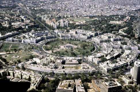

5 Spatial Growth of Delhi in Chronolological Order
6 Urban planning commenced in 1824 when a Town Duties Committee was constituted for the development of the Cantonment, Khyber Pass, the Ridge area and the Civil Lines area by the Britishers. First Municipal Committee of Delhi in 1883 and The Municipal Building byelaws were in operational in Sadar Baazar, Subzi Mandi and other suburbs. bs. City spreads with single floor spatial extents. The Delhi Improvement Trust (DIT) was contributed in March In addition to manage the acquired land, Najul Land, DIT was also assigned the job of rehabilitation of the households to be shifted from slums and substandard areas. On December 30, 1957, Delhi Development Authority (DDA) was set up under the Delhi Development Act, 1957 as a successor to DIT for the planned development of Delhi. DDA prepared a Master Plan for Delhi (MPD), which was published in The Yamuna River and terminal part of the Aravalli hill range are the two main geographical features of the city.
 Cannught place to several CBDs like Nehru Place, Bikaji Cama, Janakpuri, IP Extension.")
7 1961:Growth over years ring and radial pattern with reliance on road based transport with a hierarchy of commercial centres located on either ring or radial roads. 1971:City sprawls starts from single Central Business District (CBD) Cannught place to several CBDs like Nehru Place, Bikaji Cama, Janakpuri, IP Extension. 1981:Development of 44,770 hectares (ha) for 46 lakhs. Subsequently, development of an additional 4000 ha of urban area at Patpar Ganj (East Delhi), Sarita Vihar (South West Delhi) and Vasant Kunj (South Delhi) was added in the target of the first MPD with flats. The plotted development Delhi turns to group housing stocks.
8 Sharp increase in the density of population. In 1901, the density was 274 persons per Sq. Km persons per Sq. Km. in 1951, 9294 persons per Sq. Km. in Trend of Urbanization in Delhi Census Population Annual Exponential Year Total Urban % Urban Growth Rate

9 1991: Envisaged acquisition of 20,000 Ha of land for making a target for f development of 68,770 Ha urban area. 2001: 83,804 ha of land within the framework of MPD includes 3360 ha area for urban development along National Highways, 1996 ha of Dwarka Ph II and 9700 ha of Yamuna River bed with High Rise building. 2011:NCR projected population of 11.2 million for Delhi by 2001, on the t assumption 2 million people would be deflected to other ring towns, earlier DMA Towns: : Ghaziabad and Noida, Greater Noida, Faidabad, Gurgaon, Bahadurgarh-Kondli, Loni, Sonepath, Panipath...
10 Accomodation for Government Employee.(Ramkrisna Puram, Moti Bagh, Gol Market) Secretariat as the nucleus Growth towards Civil Lines Business Centre: : C.P., Along Ring roads,shahdara Industrial: Availability of Railroad & facilities: Rohtak Road, Najafgarh Road Okhla & Shahdara ect... Accomodation High density urban development :Public : & private (Dwarka, Patpar Ganj, Rohini, Vasant Kunj) Policy on tall Buildings, Environment and Heritage Conservation, Restriction for institional development moving towards ring towns Business Centre: Multi core PPP: Real Estate Development Change in FAR (Plotted to multi storyed) Restructuring with Mass Trasport: Metro, BRTS, DMIC, Airport expansion, Dry Port, Integrated Office Complex. 100% Area Covered, no future spatial expansion

11 Growth of Delhi Spilled over the Boundaries Inter-Dependency with Ring towns Better Connectivity with Towns Public and Private Office for Insufficient Space, Higher Land Cost move outwards The Lack of Formal Access to Appropriate Housing Traffic Congessition, in Convenience Prefer to move out Shifting and Relocation of wholesale trade activities from the central area Disperse industry to relocate in the adjoining towns
12 At this pace of population growth, the entire NCR Delhi may have to be declared as urban urban with very limited scope for horizontal expansion as the situation has reached saturation level To manage 23 million populations in NCT Delhi by 2021 will be a challenging task for all concerned NCT Delhi cannot be viewed as the sole center of development. Instead of NCT Delhi National Capital Region will be more prominant for future development. To make this possible there is need to reframe: 1.Institutional Strengthening 2. Removal of Ring Towns entity into one unit (NCR ) 3.Ensuring supply of basic services in all localities 4.Ensuring universal access to space and services 5.Augmentation of infrastructure 6.Improving physical planning and design: Urban renewal 7.Enhancing Floor Area Ratio 8.Public-Private Private partnership for revenue generation
13
14
The trends and patterns of urbanization in the NCT of Delhi during
 International Journal of Interdisciplinary and Multidisciplinary Studies (IJIMS), 2015, Vol 2, No.4, 27-39. 27 Available online at http://www.ijims.com ISSN: 2348 0343 The trends and patterns of urbanization
Measuring Disaster Risk for Urban areas in Asia-Pacific
 Measuring Disaster Risk for Urban areas in Asia-Pacific Acknowledgement: Trevor Clifford, Intl Consultant 1 SDG 11 Make cities and human settlements inclusive, safe, resilient and sustainable 11.1: By
São Paulo Metropolis and Macrometropolis - territories and dynamics of a recent urban transition
 São Paulo Metropolis and Macrometropolis - territories and dynamics of a recent urban transition Faculty of Architecture and Urbanism of São Paulo University Prof. Dr. Regina M. Prosperi Meyer WC2 - World
International Journal on Emerging Technologies 8(1): (2017) ISSN No. (Print) : ISSN No. (Online) :
: (2017) ISSN No. (Print) : ISSN No. (Online) :") e t International Journal on Emerging Technologies 8(1): 478-484(2017) ISSN No. (Print) : 0975-8364 ISSN No. (Online) : 2249-3255 Land Use Suitability Analysis for Zone K-1 (Urban Extension), New Delhi
e t International Journal on Emerging Technologies 8(1): 478-484(2017) ISSN No. (Print) : 0975-8364 ISSN No. (Online) : 2249-3255 Land Use Suitability Analysis for Zone K-1 (Urban Extension), New Delhi
MODULE 1 INTRODUCING THE TOWNSHIP RENEWAL CHALLENGE
 MODULE 1 INTRODUCING THE TOWNSHIP RENEWAL CHALLENGE FOCUS OF THE MODULE Township renewal challenges and developmental outcomes covered in this module: Historical origins of townships and the inherited
HSC Geography. Year 2013 Mark Pages 10 Published Jul 4, Urban Dynamics. By James (97.9 ATAR)
") HSC Geography Year 2013 Mark 92.00 Pages 10 Published Jul 4, 2017 Urban Dynamics By James (97.9 ATAR) Powered by TCPDF (www.tcpdf.org) Your notes author, James. James achieved an ATAR of 97.9 in 2013 while
HSC Geography Year 2013 Mark 92.00 Pages 10 Published Jul 4, 2017 Urban Dynamics By James (97.9 ATAR) Powered by TCPDF (www.tcpdf.org) Your notes author, James. James achieved an ATAR of 97.9 in 2013 while
Problems In Large Cities
 Chapter 11 Problems In Large Cities Create a list of at least 10 problems that exist in large cities. Consider problems that you have read about in this and other chapters and/or experienced yourself.
URBAN CHANGE DETECTION OF LAHORE (PAKISTAN) USING A TIME SERIES OF SATELLITE IMAGES SINCE 1972
 USING A TIME SERIES OF SATELLITE IMAGES SINCE 1972") URBAN CHANGE DETECTION OF LAHORE (PAKISTAN) USING A TIME SERIES OF SATELLITE IMAGES SINCE 1972 Omar Riaz Department of Earth Sciences, University of Sargodha, Sargodha, PAKISTAN. omarriazpk@gmail.com ABSTRACT
URBAN CHANGE DETECTION OF LAHORE (PAKISTAN) USING A TIME SERIES OF SATELLITE IMAGES SINCE 1972 Omar Riaz Department of Earth Sciences, University of Sargodha, Sargodha, PAKISTAN. omarriazpk@gmail.com ABSTRACT
Asia Pacific Ministerial Conference on Housing and Urban Development (APMCHUD) Meeting of the Working Group on Urban and Rural Planning and Management
 Meeting of the Working Group on Urban and Rural Planning and Management") Asia Pacific Ministerial Conference on Housing and Urban Development (APMCHUD) Meeting of the Working Group on Urban and Rural Planning and Management August 16 17, 2012 New Delhi Recommendations of the
Asia Pacific Ministerial Conference on Housing and Urban Development (APMCHUD) Meeting of the Working Group on Urban and Rural Planning and Management August 16 17, 2012 New Delhi Recommendations of the
Existing road transport network of the National Capital Region was examined for the existing connectivity, mobility and accessibility in the study.
 2 Road Network 2.1 Existing Road Network The existing transport network in National Capital Region is radial in nature. It comprises of expressways, national highways, state highways, major district and
The main objectives of the present study are mentioned as follows:
 Dr. Madan Mohan Assistant Professor of Geography Project Director, ICSSR (MoHRD), ND. The main objectives of the present study are mentioned as follows: to geovisualize population pressure on urban landscape;
Urbanisation & Economic Geography (2)
") GEOG1101: Introduction to Economic Geography Tuesday 20 October, 2009 Urbanisation & Economic Geography (2) Kevon Rhiney Department of Geography and Geology University of the West Indies, Mona Lecture
GEOG1101: Introduction to Economic Geography Tuesday 20 October, 2009 Urbanisation & Economic Geography (2) Kevon Rhiney Department of Geography and Geology University of the West Indies, Mona Lecture
AFRICAN URBANIZATION: SOME KEY ISSUES. Patricia Jones University of Oxford IGC Conference, Dar es Salaam 25 th February 2015
 AFRICAN URBANIZATION: SOME KEY ISSUES Patricia Jones University of Oxford IGC Conference, Dar es Salaam 25 th February 2015 Introduction New project on urbanization in Africa. World Bank funded but independent
Operational Definitions of Urban, Rural and Urban Agglomeration for Monitoring Human Settlements
 Operational Definitions of Urban, Rural and Urban Agglomeration for Monitoring Human Settlements By Markandey Rai United Nations Human Settlements Programme PO Box-30030 Nairobi, Kenya Abstract The United
Subject: Note on spatial issues in Urban South Africa From: Alain Bertaud Date: Oct 7, A. Spatial issues
 Page 1 of 6 Subject: Note on spatial issues in Urban South Africa From: Alain Bertaud Date: Oct 7, 2009 A. Spatial issues 1. Spatial issues and the South African economy Spatial concentration of economic
Urban Expansion of the City Kolkata since last 25 years using Remote Sensing
 [ VOLUME 5 I ISSUE 2 I APRIL JUNE 2018] E ISSN 2348 1269, PRINT ISSN 2349-5138 Urban Expansion of the City Kolkata since last 25 years using Remote Sensing Soumita Banerjee Researcher, Faculty Council
Urban Geography Unit Test (Version B)
") Urban Geography Unit Test (Version B) 1. What function do the majority of the world s ten most populated cities serve? a. a fortress city to resist foreign invasion b. a port city for transporting people
Urban Geography Unit Test (Version B) 1. What function do the majority of the world s ten most populated cities serve? a. a fortress city to resist foreign invasion b. a port city for transporting people
FROM INDUSTRY DEPENDENT URBAN AGGLOMERATION TO CONTEMPORARY METROPOLITAN AREA TOWARDS THE RENEWED LISBON STRATEGY
 FROM INDUSTRY DEPENDENT URBAN AGGLOMERATION TO CONTEMPORARY METROPOLITAN AREA TOWARDS THE RENEWED LISBON STRATEGY Tomasz Sławiński - architect Deputy Director Mazovian Office for Spatial Planning and Regional
National Spatial Development Perspective (NSDP) Policy Coordination and Advisory Service
 Policy Coordination and Advisory Service") National Spatial Development Perspective (NSDP) Policy Coordination and Advisory Service 1 BACKGROUND The advances made in the First Decade by far supersede the weaknesses. Yet, if all indicators were
National Spatial Development Perspective (NSDP) Policy Coordination and Advisory Service 1 BACKGROUND The advances made in the First Decade by far supersede the weaknesses. Yet, if all indicators were
Urban White Paper on Tokyo Metropolis 2002
 Urban White Paper on Tokyo Metropolis 2002 By Bureau of City Planning Tokyo Metropolitan Government Part I. "Progress in IT and City Building" Effects of computer networks on cities and cities' response
Spatiotemporal Analysis of Noida, Greater Noida and Surrounding Areas (India) Using Remote Sensing and GIS Approaches
 Using Remote Sensing and GIS Approaches") Spatiotemporal Analysis of Noida, Greater Noida and Surrounding Areas (India) Using Remote Sensing and GIS Approaches Gopal Krishna* Indian Agricultural Research Institute, New Delhi, India ABSTRACT Spatiotemporal
Spatiotemporal Analysis of Noida, Greater Noida and Surrounding Areas (India) Using Remote Sensing and GIS Approaches Gopal Krishna* Indian Agricultural Research Institute, New Delhi, India ABSTRACT Spatiotemporal
accessibility accessibility by-pass bid-rent curve bridging point administrative centre How easy or difficult a place is to reach.
 accessibility accessibility How easy or difficult a place is to reach. How easy or difficult it is to enter a building. administrative centre bid-rent curve The function of a town which is a centre for
URBAN LAND USE STRATEGIES AND INFRASTRUCTURE PROVISION IN AHMEDABAD CITY
 URBAN LAND USE STRATEGIES AND INFRASTRUCTURE PROVISION IN AHMEDABAD CITY 1 HARSH M PATEL, 2 BHUPENDRA M MARVADI 1 Student, M.E. Infrastructure Engineering, Dept. of Civil Engineering, L.D.R.P. Institute
Development of modal split modeling for Chennai
 IJMTES International Journal of Modern Trends in Engineering and Science ISSN: 8- Development of modal split modeling for Chennai Mr.S.Loganayagan Dr.G.Umadevi (Department of Civil Engineering, Bannari
Travel behavior of low-income residents: Studying two contrasting locations in the city of Chennai, India
 Travel behavior of low-income residents: Studying two contrasting locations in the city of Chennai, India Sumeeta Srinivasan Peter Rogers TRB Annual Meet, Washington D.C. January 2003 Environmental Systems,
The paper is based on commuting flows between rural and urban areas. Why is this of
 Commuting 1 The paper is based on commuting flows between rural and urban areas. Why is this of interest? Academically, extent of spread of urban agglomeration economies, also the nature of rural-urban
INTERNATIONAL JOURNAL OF GEOMATICS AND GEOSCIENCES Volume 7, No 1, 2016
 INTERNATIONAL JOURNAL OF GEOMATICS AND GEOSCIENCES Volume 7, No 1, 2016 Copyright by the authors - Licensee IPA- Under Creative Commons license 3.0 Research article ISSN 0976 4380 Urban sprawl and urban
Bishkek City Development Agency. Urban Planning Bishkek
 Bishkek City Development Agency Urban Planning Bishkek Bishkek City Development Agency Official name City budget Population Area GRP Import value Export value External trade turnover Foreign direct investments
Urban Planning for Climate Change
 Urban Planning for Climate Change FIG Working Group 8.1 Frank Friesecke, Sophie Schetke, Theo Kötter AGENDA 1. Introduction 2. Urbanisation and Climate Change 3. Need of the Surveying Profession in Dealing
Unit 7. Cities and Urban Land Use
 Unit 7 Cities and Urban Land Use Define Urbanism Population Depends on the Location Portugal Ethiopia Norway Define Urbanism Metropolitan Statistical Area Census Central City Immediate Interacting Communities
Urban Hydrology - A Case Study On Water Supply And Sewage Network For Madurai Region, Using Remote Sensing & GIS Techniques
 RESEARCH INVENTY: International Journal of Engineering and Science ISBN: 2319-6483, ISSN: 2278-4721, Vol. 1, Issue 8 (November 2012), PP 07-12 www.researchinventy.com Urban Hydrology - A Case Study On
Global Atmospheric Circulation. Past climate change and natural causes. Global climate change and human activity
 GCSE Geography Edexcel B Revision Checklist Paper 1. Global Geographical Issues Topic 1. Hazardous Earth Key Idea I know/ understand The world s climate system Global Atmospheric Circulation Past climate
Discerning sprawl factors of Shiraz city and how to make it livable
 Discerning sprawl factors of Shiraz city and how to make it livable 1. Introduction: Iran territory has now been directly affected by urban land-uses which are shaping landscapes in cities and around them.
Summary and Implications for Policy
 Summary and Implications for Policy 1 Introduction This is the report on a background study for the National Spatial Strategy (NSS) regarding the Irish Rural Structure. The main objective of the study
CHAPTER 2. Strategic Context
 CHAPTER 2 Strategic Aim: To facilitate the future development of Cork as a national gateway city within the integrated land use and transportation framework set out in the Cork Area Strategic Plan 2001
Unit 9: Changing urban environments
 Name: Unit 9: Changing urban environments I can statement... RAG Score. R=1, A=2, G=3 9.1 What are the characteristics of urbanisation. I can describe what urbanisation is. I can describe what a push and
Rupesh Kumar Gupta. Sudesh Nangia,
 Population Explosion and Land Use Changes in Gurgaon City Region-A Satellite of Delhi Metropolis Rupesh Kumar Gupta Sudesh Nangia, Key Words: Land transformation, Urban encroachment, Built-up land, Multi-Temporal,
A Remote Sensing and GIS approach to trace the Densification in Residential Areas
 A Remote Sensing and GIS approach to trace the Densification in Residential Areas Valliappan AL Assistant Professor, School of Planning and Architecture, Vijayawada, India. Date:11/03/2015 What is Densification?
GCE. Geography. Mark Scheme for January Advanced Subsidiary GCE Unit F762: Managing Change in Human Environments
 GCE Geography Advanced Subsidiary GCE Unit F762: Managing Change in Human Environments Mark Scheme for January 2012 Oxford Cambridge and RSA Examinations OCR (Oxford Cambridge and RSA) is a leading UK
THE ROLE OF REGIONAL SPATIAL PLANNING IN SUPPORTING LONG-TERM ECONOMIC GROWTH IN NORTHERN IRELAND
 THE ROLE OF REGIONAL SPATIAL PLANNING IN SUPPORTING LONG-TERM ECONOMIC GROWTH IN NORTHERN IRELAND Jenny Pyper Director 6 th Annual ICLRD Conference 20 January 2011 PURPOSE OF REGIONAL PLANNING Framework
International Court of Justice World Trade Organization Migration and its affects How & why people change the environment
 Social Issues Unit 2 Population Grade 9 Time for Completion: 12 class period State Standard: The student uses a working knowledge and understanding of the spatial organization of Earth s surface and relationships
The National Spatial Strategy
 Purpose of this Consultation Paper This paper seeks the views of a wide range of bodies, interests and members of the public on the issues which the National Spatial Strategy should address. These views
New governance mechanism for regional development in Europe. Willem Salet University of Amsterdam
 New governance mechanism for regional development in Europe Willem Salet University of Amsterdam Scheme of presentation Cities face rescaling of social and economic parameters Exploring new planning strategies
2. What is a settlement? Why do services cluster in settlements?
 Chapter 12: Services Introduction and Case Study (p. 397-399) 1. What is a service? How do LDCs and MDCs differ in regards to the number of workers employed in service- sector jobs? 2. What is a settlement?
Ireland 2040 Our Plan. National Planning Framework
 Ireland 2040 Our Plan National Planning Framework Submission on behalf of Waterford City and County Council Waterford City SE Regional Economic Driver (2040) 1 INTRODUCTION The National Planning Framework
A Study on Historical Transformation of the Urban Integration Core of Khulna City, Bangladesh
 International Journal of Innovation and Applied Studies ISSN 2028-9324 Vol. 8 No. 4 Oct. 2014, pp. 1410-1417 2014 Innovative Space of Scientific Research Journals http://www.ijias.issr-journals.org/ A
Geospatial Information for Urban Sprawl Planning and Policies Implementation in Developing Country s NCR Region: A Study of NOIDA City, India
 Geospatial Information for Urban Sprawl Planning and Policies Implementation in Developing Country s NCR Region: A Study of NOIDA City, India Dr. Madan Mohan Assistant Professor & Principal Investigator,
Chapter 10 Human Settlement Geography Book 1 Class 12
 CHAPTER 10 HUMAN SETTLEMENTS 1. RURAL, SUB URBAN AND URBAN SETTLEMENTS: This classification is common worldwide but the criteria differ from country to country. 5. Criteria for classification differs from
Making maps: Traditions and perceptions in Europe. European spatial planning and cartographic representations
 ESPON Create Europe! Making maps: Traditions and perceptions in Europe Dr. Stefanie Dühr University of the West of England, Bristol, UK European spatial planning and cartographic representations Scenarios.
Chapter 1 Data Collection
 Chapter 1 Data Collection 1. Climate of Brunei Darussalam and Temburong District Situated at around four degrees north of the Equator, Brunei Darussalam enjoys an equatorial climate with an abundance of
Dar es Salaam - Reality Check Workshop
 Dar es Salaam - Reality Check Workshop hosted by GIZ and Dar es Salaam City Council Introduction: Key Urban Characteristics of Dar es Salaam Challenges and Opportunities for Resilient Development in the
The Spatial Structure of Cities: International Examples of the Interaction of Government, Topography and Markets
 Module 2: Spatial Analysis and Urban Land Planning The Spatial Structure of Cities: International Examples of the Interaction of Government, Topography and Markets Alain Bertaud Urbanist Summary What are
Exemplar for Internal Achievement Standard. Geography Level 2
 Exemplar for Internal Achievement Standard Geography Level 2 This exemplar supports assessment against: Achievement Standard 91241 Demonstrate geographic understanding of an urban pattern An annotated
CITIES IN TRANSITION: MONITORING GROWTH TRENDS IN DELHI URBAN AGGLOMERATION
 Dela 21 2004 195-203 CITIES IN TRANSITION: MONITORING GROWTH TRENDS IN DELHI URBAN AGGLOMERATION 1991 2001 Debnath Mookherjee Western Washington University, Bellingham, Washington USA. e-mail: debnath.mookherjee@wwu.edu
Welcome to GCSE Geography. Where will it take us today?
 Welcome to GCSE Geography Where will it take us today? Urban Futures Dynamic Development Resource Reliance UK in the 21 st Century Global Hazards Changing Climate Distinctive Landscapes Sustaining Ecosystems
Chapter 9: Urban Geography
 Chapter 9: Urban Geography The Five Steps to Chapter Success Step 1: Read the Chapter Summary below, preview the Key Questions, and Geographic Concepts. Step 2: Complete the Pre-Reading Activity (PRA)
Note on Transportation and Urban Spatial Structure
 Note on Transportation and Urban Spatial Structure 1 By Alain Bertaud, Washington, ABCDE conference, April 2002 Email: duatreb@msn.com Web site: http://alain-bertaud.com/ http://alainbertaud.com/ The physical
UNIVERSITY OF KWAZULU-NATAL EXAMINATION: NOVEMBER 2012 Westville Campus : AGRICULTURE, EARTH AND ENVIRONMENTAL SCIENCES
 UNIVERSITY OF KWAZULU-NATAL EXAMINATION: NOVEMBER 2012 Westville Campus SCHOOL LEVEL MODULE CODE : AGRICULTURE, EARTH AND ENVIRONMENTAL SCIENCES : II : GEOGRAPHIES OF URBAN AND RURAL CHANGE : GEOG 220
STRATEGY FOR SPATIAL PLANNING AND RENEWAL OF URBAN POLICY: THE SOFA OF CENTRAL METROPOLITAN AREA
 KINGDOM OF MOROCCO MINISTRY OF SPATIAL DEVELOPMENT, WATER AND ENVIRONMENT STRATEGY FOR SPATIAL PLANNING AND RENEWAL OF URBAN POLICY: THE SOFA OF CENTRAL METROPOLITAN AREA STATE AND ORIENTATION OF THE SNAT
Land Use / Land Cover Change of Delhi: A Study using Remote Sensing and GIS Techniques
 International Research Journal of Earth Sciences ISSN 2321 2527 Int. Res.J. Earth Sci. Land Use / Land Cover Change of Delhi: A Study using Remote Sensing and GIS Techniques Abstract Singh Bijender 1 and
Figure 2.1: Constituent Area
 2 The Region 2.1 CONSTITUENT AREA The National Capital Region includes NCT-Delhi, nine districts of Haryana, six districts of Uttar Pradesh and one district of Rajasthan. Total area of the region is 34,144
Urban development. The compact city concept was seen as an approach that could end the evil of urban sprawl
 The compact city Outline 1. The Compact City i. Concept ii. Advantages and the paradox of the compact city iii. Key factor travel behavior 2. Urban sustainability i. Definition ii. Evaluating the compact
SRJIS/BIMONTHLY/S. A. BORUDE. ( ) APPLICATION OF SPATIAL VARIATION URBAN DENSITY MODEL: A STUDY OF AHMEDNAGAR CITY, MAHARASHTRA, INDIA
 APPLICATION OF SPATIAL VARIATION URBAN DENSITY MODEL: A STUDY OF AHMEDNAGAR CITY, MAHARASHTRA, INDIA") APPLICATION OF SPATIAL VARIATION URBAN DENSITY MODEL: A STUDY OF AHMEDNAGAR CITY, MAHARASHTRA, INDIA S.A. Borude, Assistant Professor, PG, Dept. of Geography, Ahmednagar College, Ahmednagar, Maharashtra.
APPLICATION OF SPATIAL VARIATION URBAN DENSITY MODEL: A STUDY OF AHMEDNAGAR CITY, MAHARASHTRA, INDIA S.A. Borude, Assistant Professor, PG, Dept. of Geography, Ahmednagar College, Ahmednagar, Maharashtra.
Key Issue 1: Why Do Services Cluster Downtown?
 Key Issue 1: Why Do Services Cluster Downtown? Pages 460-465 1. Define the term CBD in one word. 2. List four characteristics of a typical CBD. Using your knowledge of services from chapter 12, define
Unit 8 Settlement Geography: Urban and Rural, Cities and City Life
 Unit 8 Settlement Geography: Urban and Rural, Cities and City Life 38:180 Human Geography Settlement Geography Principally urban, but a continuum: Hamlet Village Town City plus rural World is predominantly
A New Approach to Estimating Population Growth Along a Major Arterial Highway.
 . ABSTRACT In the last twenty years Texas has undergone extensive growth as people move across the country and relocate in the Lone Star State. Many of these new Texans choose suburbs outside major cities
Declaration Population and culture
 Declaration Population and culture The ministers of the parties to the Alpine Convention regard the socio-economic and socio-cultural aspects mentioned in Article 2, Paragraph 2, Item a., as being central
Port Cities Conference: How Regional Planning can Help Support a Competitive Port. Christina DeMarco Metro Vancouver
 Port Cities Conference: How Regional Planning can Help Support a Competitive Port Christina DeMarco Metro Vancouver June 12. 2008 Metro Vancouver Regional Growth Management Three ways to help support the
It is clearly necessary to introduce some of the difficulties of defining rural and
 UNIT 2 CHANGING HUMAN ENVIRONMENTS G2 Theme 2 Investigating Settlement Change in MEDCs 2.1 What are the distinctive features of settlements? It is clearly necessary to introduce some of the difficulties
CREATING LIVEABLE & SAFE CITIES FOR ALL
 CREATING LIVEABLE & SAFE CITIES FOR ALL Taking Transit to people s door steps PRERNA V. MEHTA, MANAGER, WRI INDIA RAJEEV G. MALAGI, SR. PROJECT ASSOCIATE, WRI INDIA A product of WRI Ross Center for Sustainable
IGCSE Geography Unit 2: Types of Settlement
 IGCSE Geography Unit 2: Types of Settlement Recommended Prior Knowledge An understanding of the factors that affect the nature, location, growth and structure of settlements. A good general knowledge,
AP Human Geography Free Response Questions Categorized
 AP Human Geography Free Response Questions Categorized 2002-2010 2. Population (13-17%) 3. Over the past 150 years, Europe has changed from a source to a destination region for international migration.
Population Change. Alessandro Alasia Agriculture Division Statistics Canada. (ICRPS) Summer School 2009
 Summer School 2009") Population Change in Rural Areas Seminar presented by Alessandro Alasia Agriculture Division Statistics Canada alessandro.alasia@statcan.gc.ca International Comparative Rural Policy Studies (ICRPS) Summer
Population Change in Rural Areas Seminar presented by Alessandro Alasia Agriculture Division Statistics Canada alessandro.alasia@statcan.gc.ca International Comparative Rural Policy Studies (ICRPS) Summer
Topic 4: Changing cities
 Topic 4: Changing cities Overview of urban patterns and processes 4.1 Urbanisation is a global process a. Contrasting trends in urbanisation over the last 50 years in different parts of the world (developed,
Spatial profile of three South African cities
 Spatial Outcomes Workshop South African Reserve Bank Conference Centre Pretoria September 29-30, 2009 Spatial profile of three South African cities by Alain Bertaud September 29 Email: duatreb@msn.com
A Review of Concept of Peri-urban Area & Its Identification
 A Review of Concept of Peri-urban Area & Its Identification Ar. Manita Saxena Research Scholar Department of Architecture and Planning M.A.N.I.T, Bhopal Dr. Supriya Vyas Assistant Professor, Department
The Governance of Land Use
 The planning system Levels of government and their responsibilities The Governance of Land Use COUNTRY FACT SHEET NORWAY Norway is a unitary state with three levels of government; the national level, 19
A Method for Mapping Settlement Area Boundaries in the Greater Golden Horseshoe
 A Method for Mapping Settlement Area Boundaries in the Greater Golden Horseshoe Purpose This paper describes a method for mapping and measuring the lands designated for growth and urban expansion in the
PRIMA. Planning for Retailing in Metropolitan Areas
 PRIMA Planning for Retailing in Metropolitan Areas Metropolitan Dimension to sustainable retailing futures Metropolitan strategies Retailing in city and town centres will be a primary component of any
The effects of impact fees on urban form and congestion in Florida
 The effects of impact fees on urban form and congestion in Florida Principal Investigators: Andres G. Blanco Ruth Steiner Presenters: Hyungchul Chung Jeongseob Kim Urban and Regional Planning Contents
Unit No-1&2. Settlement Geography
 Unit No-1&2 Settlement Geography TYPES OF SETTLEMENTS Rural Settlements - agriculture as the predominant occupation. Urban settlements - principal industries are secondary and tertiary. Rural Settlement:
INSTITUTE OF TOWN PLANNERS, INDIA TOWN PLANNING EXAMINATION BOARD ASSOCIATESHIP EXAMINATION
 SUBJECT: C.1.1. Planning Theory Maximum Marks: 20 1. What is Rational Planning Model? Discuss its main features. 2. Discuss the salient features of Advocacy Planning Theory. 3. Discuss David Harvey s contribution
Urban Geography. Unit 7 - Settlement and Urbanization
 Urban Geography Unit 7 - Settlement and Urbanization Unit 7 is a logical extension of the population theme. In their analysis of the distribution of people on the earth s surface, students became aware
CHAPTER VII PATTERNS OF URBANISATION
 7.1 INTRODUCTION CHAPTER VII PATTERNS OF URBANISATION Urbanisation has been regarded as an index of the level of socio-economic development of a country; hence, the study of urbanisation assumes importance
National Planning Framework Louth County Council Submission
 National Planning Framework 2040 Louth County Council Submission 10 th November 2017 2 Louth County Council Introduction The primacy of the Dublin / Belfast corridor in the urban network on the island
Chapter 3. Trends in Growth of Open Space in Delhi
 Chapter 3 Trends in Growth of Open Space in Delhi 3.1 Introduction 3.1.1 Open space within a city is broadly defined as an area not covered by permanent structures. Thus roads, streets, water bodies, graveyards
Environmental Analysis, Chapter 4 Consequences, and Mitigation
 Environmental Analysis, Chapter 4 4.17 Environmental Justice This section summarizes the potential impacts described in Chapter 3, Transportation Impacts and Mitigation, and other sections of Chapter 4,
PLANNING FOR SUSTAINABILITY IN SLOVENIAN TOWNS
 Int. Journal for Housing Science, Vol.31, No.3 pp 205-214, 2007 Published in the United States PLANNING FOR SUSTAINABILITY IN SLOVENIAN TOWNS Mojca Sasek Divjak Urban Planning Institute of the Republic
Chelmsford Local Plan
 Chelmsford Local Plan 2021-2036. The Issues and Options Consultation document a summary Question1 Do you think that Section 3 provides an adequate range of facts and figures about Chelmsford today? If
SPATIO-TEMPORAL ANALYSIS OF URBAN POPULATION GROWTH AND DISTRIBUTION IN AURANGABAD CITY
 International Journal of Research in Social Sciences Vol. 8 Issue 3, March 2018, ISSN: 2249-2496 Impact Factor: 7.081 Journal Homepage: Double-Blind Peer Reviewed Refereed Open Access International Journal
3. HYDROMETEROLOGY. 3.1 Introduction. 3.2 Hydro-meteorological Aspect. 3.3 Rain Gauge Stations
 3. HYDROMETEROLOGY 3.1 Introduction Hydrometeorology is a branch of meteorology and hydrology that studies the transfer of water and energy between the land surface and the lower atmosphere. Detailed hydrological
CHAPTER 4 HIGH LEVEL SPATIAL DEVELOPMENT FRAMEWORK (SDF) Page 95
 Page 95") CHAPTER 4 HIGH LEVEL SPATIAL DEVELOPMENT FRAMEWORK (SDF) Page 95 CHAPTER 4 HIGH LEVEL SPATIAL DEVELOPMENT FRAMEWORK 4.1 INTRODUCTION This chapter provides a high level overview of George Municipality s
CHAPTER 4 HIGH LEVEL SPATIAL DEVELOPMENT FRAMEWORK (SDF) Page 95 CHAPTER 4 HIGH LEVEL SPATIAL DEVELOPMENT FRAMEWORK 4.1 INTRODUCTION This chapter provides a high level overview of George Municipality s
Spatial Disparities and Development Policy in the Philippines
 Spatial Disparities and Development Policy in the Philippines Arsenio M. Balisacan University of the Philipppines Diliman & SEARCA Email: arsenio.balisacan@up.edu.ph World Development Report 2009 (Reshaping
Factors Affecting Human Settlement
 Factors Affecting Human Settlement Physical Factors One of the most basic factors affecting settlement patterns is the physical geography of the land. Climate is key, because if a place is too dry, too
Edexcel Geography Advanced Paper 2
 Edexcel Geography Advanced Paper 2 SECTION B: SHAPING PLACES Assessment objectives AO1 Demonstrate knowledge and understanding of places, environments, concepts, processes, interactions and change, at
Key Issue 1: Why Do Services Cluster Downtown?
 Key Issue 1: Why Do Services Cluster Downtown? Pages 460-465 ***Always keep your key term packet out whenever you take notes from Rubenstein. As the terms come up in the text, think through the significance
Diversity of global slum conditions is a universal spatial definition of slums feasible?
 Diversity of global slum conditions is a universal spatial definition of slums feasible? Richard Sliuzas ITC Expert Group Meeting on Slum Mapping 21-23 May 2008 INTERNATIONAL INSTITUTE FOR GEO-INFORMATION
Regional Snapshot Series: Transportation and Transit. Commuting and Places of Work in the Fraser Valley Regional District
 Regional Snapshot Series: Transportation and Transit Commuting and Places of Work in the Fraser Valley Regional District TABLE OF CONTENTS Complete Communities Daily Trips Live/Work Ratio Commuting Local
Vincent Goodstadt. Head of European Affairs METREX European Network
 Vincent Goodstadt Head of European Affairs METREX European Network METREX (Network of 50 European Metropolitan Regions and Areas ) Exchanging Knowledge (e.g. Benchmarking) Climate Change CO2/80/50 Expertise
Mr. Chairman, Hon ble Ministers, Excellencies, Distinguished participants, Ladies and Gentlemen.
 Ministerial Level Exchange of Views on National Experiences on improving transport connectivity and trade facilitation for the achievement of the SDGs: BHUTAN Mr. Chairman, Hon ble Ministers, Excellencies,