Accessibility Instruments in Planning Practice Spatial Network Analysis for Multi-Modal Transport Systems (SNAMUTS): Adelaide
|
|
|
- Jeffrey Merritt
- 5 years ago
- Views:
Transcription
: Adelaide Prof Carey Curtis, Dr Jan Scheurer, Roger Mellor, Oscar Thomson Curtin University,")
1 Accessibility Instruments in Planning Practice Spatial Network Analysis for Multi-Modal Transport Systems (SNAMUTS): Adelaide Prof Carey Curtis, Dr Jan Scheurer, Roger Mellor, Oscar Thomson Curtin University, Perth
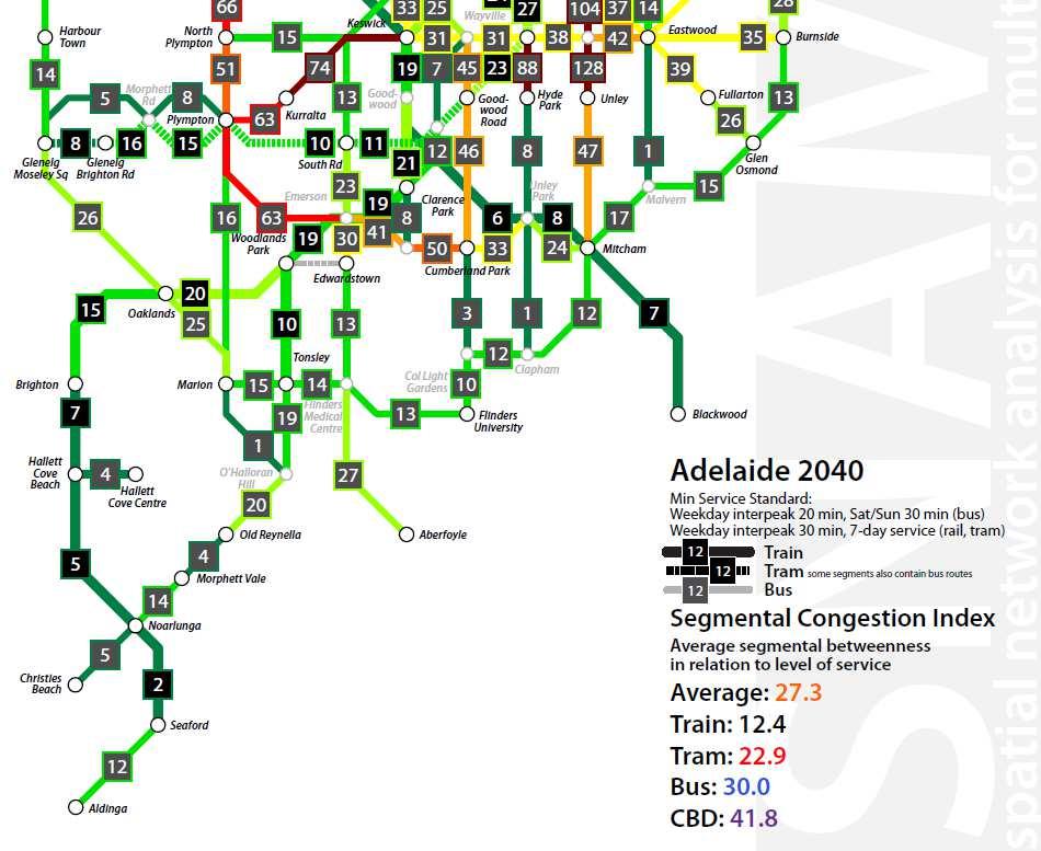
2 snamuts adelaide: sketching a 2040 public transport network Rail infrastructure development: Electrification of entire network (except Belair line) CBD rail tunnel Adelaide Central Keswick All-day 15-minute frequencies per line, with 2-3 lines overlapping on the trunk routes. Tram extension from Bowden to West Lakes and Semaphore, partially using heavy rail tracks. Boosting bus services: Focus on orbital and east-west routes. 15-minute (or better) frequencies to access all sub-centres and activity corridors identified in metropolitan strategy. Some rerouting of lines away from the CBD area.
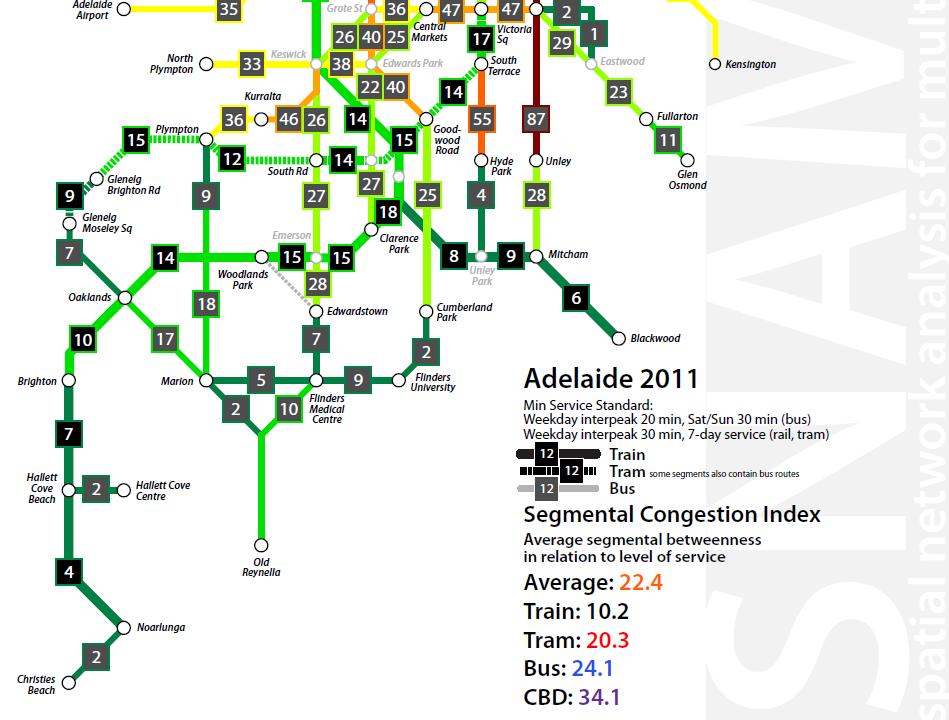
3 adelaide: service intensity Number of vehicles/train sets required in simultaneous operation for the minimum standard network (20 min weekdays, 30 min weekends for trams and buses, 30 minutes weekdays for trains) Trains Trams total: per 100,000 pop (2011) Buses 191
4 adelaide: service intensity Number of vehicles/train sets required in simultaneous operation for the minimum standard network (20 min weekdays, 30 min weekends for trams and buses, 30 minutes weekdays for trains) Trains Trams total: per 100,000 pop (2040) Buses 255
5 6 key snamuts indicators Closeness Centrality Ease of Movement Degree Centrality Transfer Intensity 30-minute Contour Catchment Betweenness Centrality Geographical Distribution of Travel Opportunities Network Stress Identifying Squeeze Points and Underused Potential Nodal Connectivity Attractiveness for PT-oriented Land Use Intensification Composite Index: combines all 6 measures by allocating between 0 and 10 points to each (maximum 60)
6 closeness centrality What is the ease of movement across the network? [smaller values indicate better accessibility performance]

7
8 degree centrality What is the transfer intensity of the network? [smaller values indicate better accessibility performance]
9
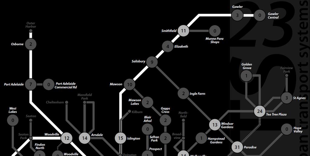
10 contour catchments How many residents and jobs can you access within 30 minutes from each activity node? Some assumptions: One transfer is allowed within 30 min, but only between services that both run at least every 15 min A flat deduction applies for making the transfer, equivalent to the actual average transfer time across the network (usually between 6 and 8 minutes)
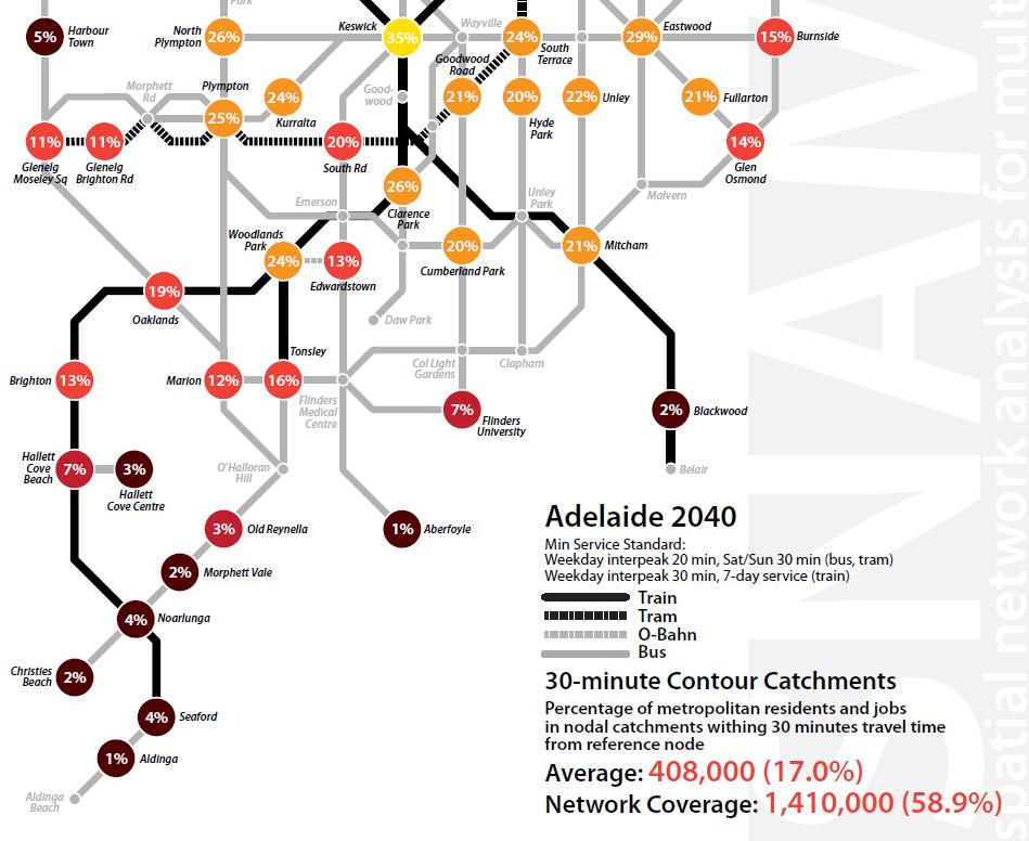
11
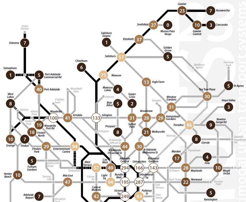
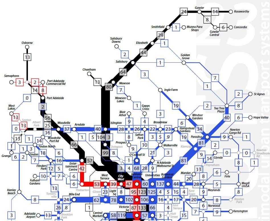
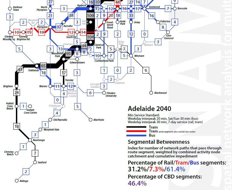
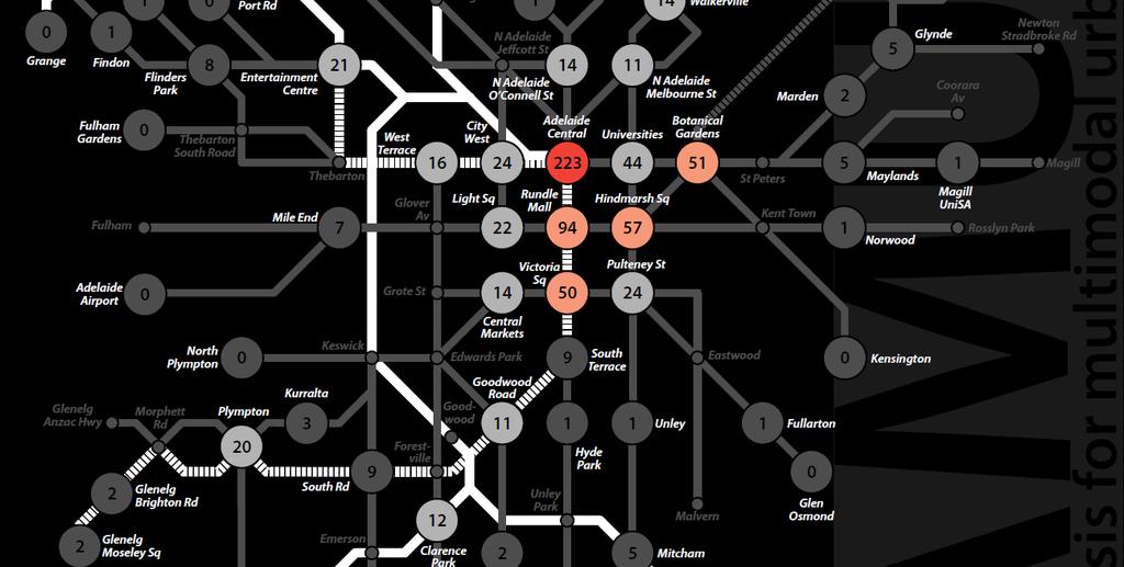
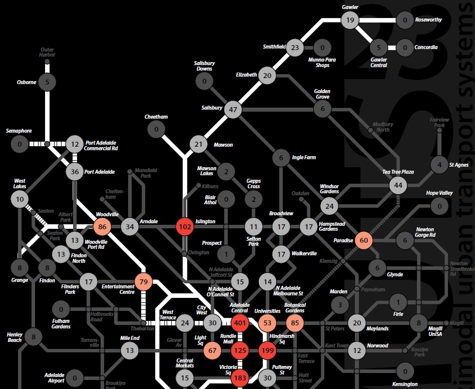
12 betweenness centrality How are travel opportunities distributed across the network? Betweenness centrality defines preferred travel paths between each pair of nodes, and counts them at nodes and route segments to determine their strategic significance
13

14

15
16 nodal connectivity To what extent do network nodes function as hubs for movement? The connectivity index measures each node s connectedness to other nodes, and its capacity for making transfers or stopovers.
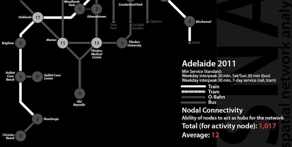
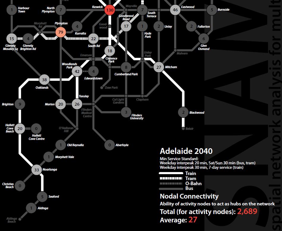
17
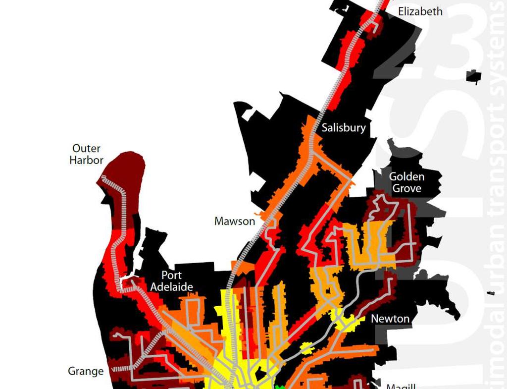
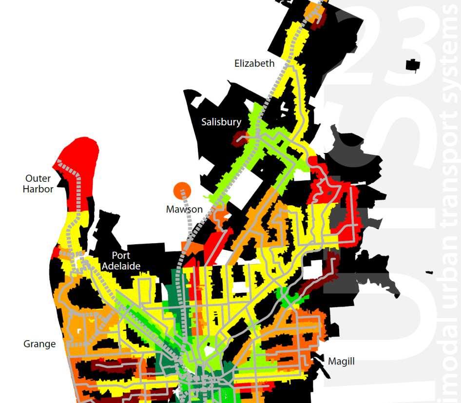
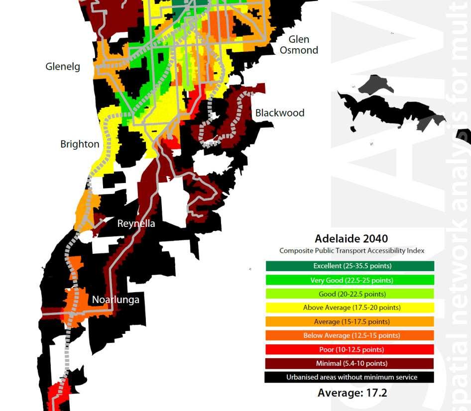
18 snamuts composite index Good, average and poor public transport accessibility on a scale map

19
20 adelaide 2040: what are we achieving? Network coverage: increases from 48% to 59% of metropolitan residents and jobs. Operational input: comparable to the status quo relative to population (provided the growth projections materialise!) Better integration of modes in the CBD by penetrating the central area with rail, and making the bus system more legible. Addition of orbital lines at minimum 15-minute frequencies allows for easier travel along geographical desire lines. Integration of rail and bus improves particularly in the northern suburbs (Islington and Woodville as major rail-bus transfers). Significance of the CBD drops from 62% to 46% of travel opportunities (still high compared to other cities though)
Accessibility Instruments in Planning Practice Spatial Network Analysis for Multi-Modal Transport Systems (SNAMUTS): Adelaide
: Adelaide") Accessibility Instruments in Planning Practice Spatial Network Analysis for Multi-Modal Transport Systems (SNAMUTS): Adelaide Prof Carey Curtis, Dr Jan Scheurer, Roger Mellor, Oscar Thomson Curtin University,
Accessibility Instruments in Planning Practice Spatial Network Analysis for Multi-Modal Transport Systems (SNAMUTS): Adelaide Prof Carey Curtis, Dr Jan Scheurer, Roger Mellor, Oscar Thomson Curtin University,
accessibility instruments in planning practice
 accessibility instruments in planning practice Spatial Network Analysis for Multi-Modal Transport Systems (SNAMUTS): Helsinki Prof Carey Curtis, Dr Jan Scheurer, Curtin University, Perth - RMIT University,
Benchmarking Accessibility and Public Transport Network Performance in Copenhagen and Perth
 Institute of Transport Studies, Monash University World Transit Research World Transit Research 1-1-2010 Benchmarking Accessibility and Public Transport Network Performance in Copenhagen and Perth Jan
Benchmarking public transport accessibility in Australasian cities
 Curtis and Scheurer 35 th Australasian Transport Research Forum 2012 Benchmarking public transport accessibility in Australasian cities Carey Curtis (Curtin University) Jan Scheurer (RMIT University/Curtin
Measuring connectivity in London
 Measuring connectivity in London OECD, Paris 30 th October 2017 Simon Cooper TfL City Planning 1 Overview TfL Connectivity measures in TfL PTALs Travel time mapping Catchment analysis WebCAT Current and
Transit Time Shed Analyzing Accessibility to Employment and Services
 Transit Time Shed Analyzing Accessibility to Employment and Services presented by Ammar Naji, Liz Thompson and Abdulnaser Arafat Shimberg Center for Housing Studies at the University of Florida www.shimberg.ufl.edu
Performance measures for public transport accessibility: Learning from international practice
 The Journal of Transport and Land Use http://jtlu.org Vol. 10 No. 1 [2017] pp. 93 118 Performance measures for public transport accessibility: Learning from international practice Carey Curtis Curtin University
Foreword. Vision and Strategy
 GREATER MANCHESTER SPATIAL FRAMEWORK Friends of Walkden Station Consultation Response January 2017 Foreword Friends of Walkden Station are a group of dedicated volunteers seeking to raise the status and
Assessing spatial distribution and variability of destinations in inner-city Sydney from travel diary and smartphone location data
 Assessing spatial distribution and variability of destinations in inner-city Sydney from travel diary and smartphone location data Richard B. Ellison 1, Adrian B. Ellison 1 and Stephen P. Greaves 1 1 Institute
Analyzing the Market Share of Commuter Rail Stations using LEHD Data
 Analyzing the Market Share of Commuter Rail Stations using LEHD Data Using Census Data for Transportation Applications Conference, Irvine, CA October 26, 2011 1. What is the size of Metrolink s commute
Public Transport and Land Use Integration in Melbourne and Hamburg: Can Comparative Network Performance Provide a Sense of Future Direction?
 Public Transport and Land Use Integration in Melbourne and Hamburg: Can Comparative Network Performance Provide a Sense of Future Direction? Public Transport and Land Use Integration in Melbourne and Hamburg:
Land use/transport integration: the vital role of our forgotten middle suburbs. March 2016
 Land use/transport integration: the vital role of our forgotten middle suburbs March 2016 Presented by Adjunct Professor John Stanley Institute of Transport and Logistics Studies (ITLS) The University
The 3V Approach. Transforming the Urban Space through Transit Oriented Development. Gerald Ollivier Transport Cluster Leader World Bank Hub Singapore
 Transforming the Urban Space through Transit Oriented Development The 3V Approach Gerald Ollivier Transport Cluster Leader World Bank Hub Singapore MDTF on Sustainable Urbanization The China-World Bank
Regional Transit Development Plan Strategic Corridors Analysis. Employment Access and Commuting Patterns Analysis. (Draft)
") Regional Transit Development Plan Strategic Corridors Analysis Employment Access and Commuting Patterns Analysis (Draft) April 2010 Contents 1.0 INTRODUCTION... 4 1.1 Overview and Data Sources... 4 1.2
Regional Transit Development Plan Strategic Corridors Analysis Employment Access and Commuting Patterns Analysis (Draft) April 2010 Contents 1.0 INTRODUCTION... 4 1.1 Overview and Data Sources... 4 1.2
Note on Transportation and Urban Spatial Structure
 Note on Transportation and Urban Spatial Structure 1 By Alain Bertaud, Washington, ABCDE conference, April 2002 Email: duatreb@msn.com Web site: http://alain-bertaud.com/ http://alainbertaud.com/ The physical
Transit-Oriented Development. Christoffer Weckström
 Transit-Oriented Development Christoffer Weckström 31.10.2017 Outline Context of Transit-oriented Development Elements of Transit-oriented Development A short history of land use and transit integration
Developing harmonised indicators on urban public transport in Europe
 Developing harmonised indicators on urban public transport in Europe Hugo Poelman European Commission DG Regional and Urban GIS team Regional May 2015 context EU Cohesion European Regional Development
Superior mobility achieved through an alternative to heavy rail Melbourne south-east case study
 Australasian Transport Research Forum 2015 Proceedings 30 September - 2 October 2015, Sydney, Australia Publication website: http://www.atrf.info/papers/index.aspx Superior mobility achieved through an
Session 3: Spatial Diagnosis of Mobility and Accessibility in Urban Mobility Systems
 MESTRADO EM ENGENHARIA CIVIL MESTRADO EM URBANISMO E ORDENAMENTO DO TERRITÓRIO MESTRADO EM PLANEAMENTO E OPERAÇÃO DE TRANSPORTES Urban Mobility Management Main lecturer: Prof. Rosário Macário Assistent:
Accessibility as an Instrument in Planning Practice. Derek Halden DHC 2 Dean Path, Edinburgh EH4 3BA
 Accessibility as an Instrument in Planning Practice Derek Halden DHC 2 Dean Path, Edinburgh EH4 3BA derek.halden@dhc1.co.uk www.dhc1.co.uk Theory to practice a starting point Shared goals for access to
Assessing the Employment Agglomeration and Social Accessibility Impacts of High Speed Rail in Eastern Australia: Sydney-Canberra-Melbourne Corridor
 Assessing the Employment Agglomeration and Social Accessibility Impacts of High Speed Rail in Eastern Australia: Sydney-Canberra-Melbourne Corridor Professor David A. Hensher FASSA Founding Director Institute
THE ROLE OF REGIONAL SPATIAL PLANNING IN SUPPORTING LONG-TERM ECONOMIC GROWTH IN NORTHERN IRELAND
 THE ROLE OF REGIONAL SPATIAL PLANNING IN SUPPORTING LONG-TERM ECONOMIC GROWTH IN NORTHERN IRELAND Jenny Pyper Director 6 th Annual ICLRD Conference 20 January 2011 PURPOSE OF REGIONAL PLANNING Framework
Policy Note 6. Measuring Unemployment by Location and Transport: StepSA s Access Envelope Technologies
 6 Measuring Unemployment by Location and Transport: StepSA s Access Envelope Technologies Introduction Increasing emphasis is coming onto spatial planning as government in South Africa moves to address
City sustainability: a transport perspective a journey continues
 Sustainable Development, Vol. 2 833 City sustainability: a transport perspective a journey continues K. Doust1,2, C. Wang1 & T. Doust2 1 Research Centre for Integrated Transport Innovation (rciti), University
Crow River Plaza - Retail Development South Diamond Lake Rd. Rogers, MN FOR LEASE 1,024 SF Retail Space. Lease Rate: $16.
 FEATURES: - Available in Rogers, MN Lease Rate: $16.00 / psf NNN - Excellent location with freeway signage on I-94! - Near large retailers such as Target, Kohls, & Applebees. Taxes $3.65 / psf Cam $3.20
Implementation Status & Results Vietnam Danang Sustainable City Development Project (SCDP) (P123384)
 (P123384)") Public Disclosure Authorized Public Disclosure Authorized The World Bank Implementation Status & Results Vietnam Danang Sustainable City Development Project (SCDP) (P123384) Operation Name: Danang Sustainable
Public Disclosure Authorized Public Disclosure Authorized The World Bank Implementation Status & Results Vietnam Danang Sustainable City Development Project (SCDP) (P123384) Operation Name: Danang Sustainable
APPENDIX IV MODELLING
 APPENDIX IV MODELLING Kingston Transportation Master Plan Final Report, July 2004 Appendix IV: Modelling i TABLE OF CONTENTS Page 1.0 INTRODUCTION... 1 2.0 OBJECTIVE... 1 3.0 URBAN TRANSPORTATION MODELLING
Kansainvälinen kesäseminaari: URBAANIA SAAVUTETTAVUUTTA ANALYSOIMASSA - Analysing urban accessibility -
 Kansainvälinen kesäseminaari: URBAANIA SAAVUTETTAVUUTTA ANALYSOIMASSA - Analysing urban accessibility - SNAMUTS MetropAccess 2 Carey Curtis Curti Universoty 3 Tilaisuuden ohjelma / program 9:00-9:30 MetropAccess-hankkeen
Analysis of the urban travel structure using smartcard and GPS data from Santiago, Chile
 Analysis of the urban travel structure using smartcard and GPS data from Santiago, Chile Marcela Munizaga, Felipe Hernández, Universidad de Chile Ricardo Hurtubia, Pontificia Universidad Católica de Chile
Crow River Plaza - Retail Development South Diamond Lake Rd. Rogers, MN FOR LEASE 2,066 SF Retail Space. Lease Rate: $16.
 FEATURES: - 2,066 SF End Cap Retail Space Available in Rogers, MN - Excellent location with freeway signage on I-94! - Near large retailers such as Target, Kohls, & Applebees. - Convenient location off
Coordinated Transit and Land Use Planning in the Region of Waterloo
 Coordinated Transit and Land Use Planning in the Region of Waterloo Jeffrey M. Casello University of Waterloo Kevin Curtis Graham Vincent Region of Waterloo Transportation Research Board Best Practices:
Data driven approaches to Urban Planning Experience from Derry/Londonderry
 Data driven approaches to Urban Planning Experience from Derry/Londonderry Anna Rose RTPI Belfast 11 th of September 1 June 26 07:47AM 2 The value of the City The space of the city is a theatre: playing
True Smart and Green City? 8th Conference of the International Forum on Urbanism
 ,, doi:10.3390/ifou-. True Smart and Green City? 8th Conference of the International Forum on Urbanism Conference Proceedings Paper Comparable Measures of Accessibility to Public Transport by the General
CIV3703 Transport Engineering. Module 2 Transport Modelling
 CIV3703 Transport Engineering Module Transport Modelling Objectives Upon successful completion of this module you should be able to: carry out trip generation calculations using linear regression and category
TRANSPORTATION MODELING
 TRANSPORTATION MODELING Modeling Concept Model Tools and media to reflect and simple a measured reality. Types of Model Physical Model Map and Chart Model Statistics and mathematical Models MODEL? Physical
Towards a Co-ordinated Planning of Infrastructure and Urbanization
 Towards a Co-ordinated Planning of Infrastructure and Urbanization Problems, Solutions and Conditions for Success in the current Dutch Policy and Planning Practice Content of presentation Content of presentation
Sustainable Suburbs: Restructuring Suburban Development
 Sustainable Suburbs: Restructuring Suburban Development Stephen B. Friedman, AICP, CRE ULI Forum, October 8, 2009 The Vocabulary of Growth CAVE NIMBY BANANA NOTE NOPE NIMEY Triple Bottom Line Profitability
Travel Related Urban Zones in Finland
 Travel Related Urban Zones in Finland Theory of Urban Fabrics Seminar in Helsinki, SYKE, 24.10.2013 Mika Ristimäki, Maija Tiitu, Ville Helminen, Panu Söderström, Kari Oinonen Finnish Environment Institute
City of Johannesburg Department: Development Planning And Urban Management Development Planning and Facilitation
 City of Johannesburg Department: Development Planning And Urban Management Development Planning and Facilitation Marlboro Urban Development Framework: Discussion Document July 2007 1 Prepared for Department
Mapping cities by transit riders trajectories: The case of Brisbane, Australia. Citation Environment and Planning A, 2017, v. 49 n. 8, p.
 Title Mapping cities by transit riders trajectories: The case of Brisbane, Australia Author(s) Zhou, J; Corcoran, J; Borsellino, R Citation Environment and Planning A, 2017, v. 49 n. 8, p. 1707-1709 Issued
Factors Affecting Human Settlement
 Factors Affecting Human Settlement Physical Factors One of the most basic factors affecting settlement patterns is the physical geography of the land. Climate is key, because if a place is too dry, too
Mapping Accessibility Over Time
 Journal of Maps, 2006, 76-87 Mapping Accessibility Over Time AHMED EL-GENEIDY and DAVID LEVINSON University of Minnesota, 500 Pillsbury Drive S.E., Minneapolis, MN 55455, USA; geneidy@umn.edu (Received
The World Bank China: Qinghai Xining Urban Transport Project (P127867)
") Public Disclosure Authorized EAST ASIA AND PACIFIC China Transport & ICT Global Practice IBRD/IDA Investment Project Financing FY 2014 Seq No: 6 ARCHIVED on 27-Jun-2016 ISR24068 Implementing Agencies:
Public Disclosure Authorized EAST ASIA AND PACIFIC China Transport & ICT Global Practice IBRD/IDA Investment Project Financing FY 2014 Seq No: 6 ARCHIVED on 27-Jun-2016 ISR24068 Implementing Agencies:
National Planning Framework Louth County Council Submission
 National Planning Framework 2040 Louth County Council Submission 10 th November 2017 2 Louth County Council Introduction The primacy of the Dublin / Belfast corridor in the urban network on the island
Rail Baltica Is this project economically justified?
 Rail Baltica Is this project economically justified? CEE Rail Infrastructure Forum 2008: High speed operations within an efficient railway system Points of reference TEN-T goals and objectives Environmental
Estimating Large Scale Population Movement ML Dublin Meetup
 Deutsche Bank COO Chief Data Office Estimating Large Scale Population Movement ML Dublin Meetup John Doyle PhD Assistant Vice President CDO Research & Development Science & Innovation john.doyle@db.com
STILLORGAN QBC LEVEL OF SERVICE ANALYSIS
 4-5th September, STILLORGAN QBC LEVEL OF SERVICE ANALYSIS Mr David O Connor Lecturer Dublin Institute of Technology Mr Philip Kavanagh Graduate Planner Dublin Institute of Technology Abstract Previous
Transport Planning in Large Scale Housing Developments. David Knight
 Transport Planning in Large Scale Housing Developments David Knight Large Scale Housing Developments No longer creating great urban spaces in the UK (Hall 2014) Transport Planning Transport planning processes
Promoting synergy between airports and cities to achieve sustainable development
 Promoting synergy between airports and cities to achieve sustainable development Content 1. Airports / Aviation 2. Urbanization 3. Shared Threads & Opportunities 4. Synergistic Development for Sustainability
INSTITUTE OF POLICY AND PLANNING SCIENCES. Discussion Paper Series
 INSTITUTE OF POLICY AND PLANNING SCIENCES Discussion Paper Series No. 1102 Modeling with GIS: OD Commuting Times by Car and Public Transit in Tokyo by Mizuki Kawabata, Akiko Takahashi December, 2004 UNIVERSITY
BROOKINGS May
 Appendix 1. Technical Methodology This study combines detailed data on transit systems, demographics, and employment to determine the accessibility of jobs via transit within and across the country s 100
Effects of a non-motorized transport infrastructure development in the Bucharest metropolitan area
 The Sustainable City IV: Urban Regeneration and Sustainability 589 Effects of a non-motorized transport infrastructure development in the Bucharest metropolitan area M. Popa, S. Raicu, D. Costescu & F.
Designing TOD precincts: accessibility and travel patterns. Doina Olaru 1 Business School, University of Western Australia, Australia.
 EJTIR Issue 15(1), 2015 pp. 6-26 ISSN: 1567-7141 tlo.tbm.tudelft.nl/ejtir Designing TOD precincts: accessibility and travel patterns Doina Olaru 1 Business School, University of Western Australia, Australia.
Prepared for: San Diego Association Of Governments 401 B Street, Suite 800 San Diego, California 92101
 Activity-Based Travel Model Validation for 2012 Using Series 13 Data: Coordinated Travel Regional Activity Based Modeling Platform (CT-RAMP) for San Diego County Prepared for: San Diego Association Of
South East Growth Corridor - VITM project
 Growth Areas Authority 20 Jan 2012 South East Growth Corridor - VITM project Final Report South East Growth Corridor - VITM project Final Report Prepared for Growth Areas Authority Prepared by AECOM Australia
The spatial network Streets and public spaces are the where people move, interact and transact
 The spatial network Streets and public spaces are the where people move, interact and transact The spatial network Cities are big spatial networks that create more of these opportunities Five key discoveries
East Bay BRT. Planning for Bus Rapid Transit
 East Bay BRT Planning for Bus Rapid Transit Regional Vision Draper Prison The Bottleneck is a State-Level issue, Salt Lake County 2050 Population: 1.5M Draper Prison hopefully with some State-Level funding!
Investigating the Transit-Orientation of Existing Urban Development Around Melbourne Trams Compared to Other Public Transport Modes
 Australasian Transport Research Forum 2015 Proceedings 30 September - 2 October 2015, Sydney, Australia Publication website: http://www.atrf.info/papers/index.aspx Investigating the Transit-Orientation
GIS Analysis of Crenshaw/LAX Line
 PDD 631 Geographic Information Systems for Public Policy, Planning & Development GIS Analysis of Crenshaw/LAX Line Biying Zhao 6679361256 Professor Barry Waite and Bonnie Shrewsbury May 12 th, 2015 Introduction
How the science of cities can help European policy makers: new analysis and perspectives
 How the science of cities can help European policy makers: new analysis and perspectives By Lewis Dijkstra, PhD Deputy Head of the Economic Analysis Unit, DG Regional and European Commission Overview Data
# HOW CENTRAL IS THE RAIL STATION? Incorporating Rail Centrality with Development Potential
 #80 YOAV LERMAN Hebrew University of Jerusalem, Jerusalem, Israel yoavlerman@gmail.com YONATAN LEBENDIGER PlaNet Consultancy, Tel Aviv, Israel yonatan.arch@gmail.com ABSTRACT The study presented in this
CITY OF CAMBRIDGE Growth & Intensification Study Secondary Plan Stakeholder Session June 26th, 2017
 CITY OF CAMBRIDGE Growth & Intensification Study Secondary Plan Stakeholder Session June 26th, 2017 Dillon Consulting Limited Watson & Associates Economists Curtis Planning Inc. Tim Welch Consulting Inc.
Visitor Flows Model for Queensland a new approach
 Visitor Flows Model for Queensland a new approach Jason. van Paassen 1, Mark. Olsen 2 1 Parsons Brinckerhoff Australia Pty Ltd, Brisbane, QLD, Australia 2 Tourism Queensland, Brisbane, QLD, Australia 1
Lecture 19: Common property resources
 Lecture 19: Common property resources Economics 336 Economics 336 (Toronto) Lecture 19: Common property resources 1 / 19 Introduction Common property resource: A resource for which no agent has full property
Travel behavior of low-income residents: Studying two contrasting locations in the city of Chennai, India
 Travel behavior of low-income residents: Studying two contrasting locations in the city of Chennai, India Sumeeta Srinivasan Peter Rogers TRB Annual Meet, Washington D.C. January 2003 Environmental Systems,
I. M. Schoeman North West University, South Africa. Abstract
 Urban Transport XX 607 Land use and transportation integration within the greater area of the North West University (Potchefstroom Campus), South Africa: problems, prospects and solutions I. M. Schoeman
Crossrail 2. Michele Dix. June Transport for London
 Crossrail 2 Michele Dix June 2015 Transport for London London is growing by... new residents every hour That s a car load every minutes 2 Buses every day 2 Tube or or trains every week Today the population
European spatial policy and regionalised approaches
 Findings of the ESPON 2006 Programme COMMIN Final Conference 26-27 April 2007 European spatial policy and regionalised approaches by Dr. Kai BöhmeB ! Territory matters Structure of presentation! Territorial
transportation research in policy making for addressing mobility problems, infrastructure and functionality issues in urban areas. This study explored
 ABSTRACT: Demand supply system are the three core clusters of transportation research in policy making for addressing mobility problems, infrastructure and functionality issues in urban areas. This study
Deep Thunder. Local Area Precision Forecasting for Weather-Sensitive Business Operations (e.g. Electric Utility)
") 1 Deep Thunder Local Area Precision Forecasting for Weather-Sensitive Business Operations (e.g. Electric Utility) Dipl. Ing. Helmut Ludwar Chief Technologist Wien, im Oktober 2010 Forecasts for Weather-Sensitive
1 Deep Thunder Local Area Precision Forecasting for Weather-Sensitive Business Operations (e.g. Electric Utility) Dipl. Ing. Helmut Ludwar Chief Technologist Wien, im Oktober 2010 Forecasts for Weather-Sensitive
CORRIDORS OF FREEDOM Access Management (Ability) Herman Pienaar: Director City Transformation and Spatial Planning
 Herman Pienaar: Director City Transformation and Spatial Planning") CORRIDORS OF FREEDOM Access Management (Ability) 2016 Herman Pienaar: Director City Transformation and Spatial Planning PLANNING DEVELOPMENT PROCESS RATHER THAN A PLAN CAPITAL INVESTMENT DEVELOPMENT FACILITATION
CORRIDORS OF FREEDOM Access Management (Ability) 2016 Herman Pienaar: Director City Transformation and Spatial Planning PLANNING DEVELOPMENT PROCESS RATHER THAN A PLAN CAPITAL INVESTMENT DEVELOPMENT FACILITATION
High speed network in Hauts-de-France Region. Värnamo, 17 th May 2018
 High speed network in Hauts-de-France Region Värnamo, 17 th May 2018 Hauts-de-France at the crossroads of the North-West Europe High speed train approach in France In the 1980s: will to link the main cities
Integrated Infrastructure Planning & Spatial Mapping
 Integrated Infrastructure Planning & Spatial Mapping Presenter: Heidi Dixon, Principal Social Planner, DTPLI 23 May 2014 PART 1 PLAN MELBOURNE : Metropolitan Planning Strategy PART 2 Case Study: DTPLI
Identifying Megaregions in the US: Implications for Infrastructure Investment
 7. 10. 2 0 08 Identifying Megaregions in the US: Implications for Infrastructure Investment Dr. Myungje Woo Dr. Catherine L. Ross Jason Barringer Harry West Jessica Lynn Harbour Doyle Center for Quality
The Governance of Land Use
 The planning system The Governance of Land Use United Kingdom Levels of government and their responsibilities The United Kingdom is a unitary state with three devolved governments in Northern Ireland,
Growth Management: Analysis of Comments Received and Responses Comments received as of October 16, 2017
 Growth Management: Analysis of Comments Received and s Comments received as of October 16, Comments informing the Region of Peel s growth management work have been summarized with responses below. These
Edexcel Geography Advanced Paper 2
 Edexcel Geography Advanced Paper 2 SECTION B: SHAPING PLACES Assessment objectives AO1 Demonstrate knowledge and understanding of places, environments, concepts, processes, interactions and change, at
Examining the Potential Travellers in Catchment Areas for Public Transport
 Examining the Potential Travellers in Catchment Areas for Public Transport Alex Landex Research Assistant, M.Sc. Centre for Traffic and Transport (CTT) Technical University of Denmark (DTU) Bygningstorvet,
Spatial Analysis: A Multi-Sectoral Program in Support of Economic Transformation The World Bank
 Spatial Analysis: A Multi-Sectoral Program in Support of Economic Transformation The World Bank AFTSD Presentation to the E-DPG March 8, 2012 What do we mean by spatial analysis? Use of Geographical Information
Prediction of land use and transport changes in dynamic environments modelling the bipolar Vienna Bratislava metropolitan region
 Prediction of land use and transport changes in dynamic environments modelling the bipolar Vienna Bratislava metropolitan region CUPUM 07 11-13 July 2007 Iguassu Falls, Brasilia The region Vienna Bratislava:
MULTIPLE CHOICE. Choose the one alternative that best completes the statement or answers the question.
 AP Test 13 Review Name MULTIPLE CHOICE. Choose the one alternative that best completes the statement or answers the question. 1) Compared to the United States, poor families in European cities are more
Subway Climatology at Newrail; Brian Agnew and Qian Zi
 Subway Climatology at Newrail; Brian Agnew and Qian Zi NewRail at Newcastle University is now the UK centre for the study of Subway Climatology which is a relatively new field of study that was pioneered
URBAN TRANSPORTATION SYSTEM (ASSIGNMENT)
") BRANCH : CIVIL ENGINEERING SEMESTER : 6th Assignment-1 CHAPTER-1 URBANIZATION 1. What is Urbanization? Explain by drawing Urbanization cycle. 2. What is urban agglomeration? 3. Explain Urban Class Groups.
BRANCH : CIVIL ENGINEERING SEMESTER : 6th Assignment-1 CHAPTER-1 URBANIZATION 1. What is Urbanization? Explain by drawing Urbanization cycle. 2. What is urban agglomeration? 3. Explain Urban Class Groups.
Forecasts from the Strategy Planning Model
 Forecasts from the Strategy Planning Model Appendix A A12.1 As reported in Chapter 4, we used the Greater Manchester Strategy Planning Model (SPM) to test our long-term transport strategy. A12.2 The origins
Urban Geography Unit Test (Version B)
") Urban Geography Unit Test (Version B) 1. What function do the majority of the world s ten most populated cities serve? a. a fortress city to resist foreign invasion b. a port city for transporting people
Urban Geography Unit Test (Version B) 1. What function do the majority of the world s ten most populated cities serve? a. a fortress city to resist foreign invasion b. a port city for transporting people
Transportation and Social Equity as a Way to Alleviate Poverty
 Transportation and Social Equity as a Way to Alleviate Poverty The Case of Low-Income Neighborhoods in Savannah, GA Vishanya F. Forbes1, Dr. Deden Rukmana2 What is Social Equity? It s a term that implies
Data Collection. Lecture Notes in Transportation Systems Engineering. Prof. Tom V. Mathew. 1 Overview 1
 Data Collection Lecture Notes in Transportation Systems Engineering Prof. Tom V. Mathew Contents 1 Overview 1 2 Survey design 2 2.1 Information needed................................. 2 2.2 Study area.....................................
Alternatives Analysis
 Alternatives Analysis Prepared for: Metropolitan Atlanta Rapid Transit Authority Prepared by: AECOM/Jacobs-JJG Joint Venture Atlanta, GA November 2012 Page Left Intentionally Blank ii TABLE OF CONTENTS
The World Bank Ho Chi Minh City Green Transport Development (P126507)
") Public Disclosure Authorized EAST ASIA AND PACIFIC Vietnam Transport & ICT Global Practice IBRD/IDA Investment Project Financing FY 2015 Seq No: 6 ARCHIVED on 25-Dec-2017 ISR31002 Implementing Agencies:
Public Disclosure Authorized EAST ASIA AND PACIFIC Vietnam Transport & ICT Global Practice IBRD/IDA Investment Project Financing FY 2015 Seq No: 6 ARCHIVED on 25-Dec-2017 ISR31002 Implementing Agencies:
Accessibility patterns: Bavaria Case Study 1
 EUROPA XXI Vol. 24, 2013, pp. 49-59 http://dx.doi.org/10.7163/eu21.2013.24.4 Institute of Geography and Spatial Organization Polish Academy of Sciences www.igipz.pan.pl Accessibility patterns: Bavaria
The sustainable location of low-income housing development in South African urban areas
 Sustainable Development and Planning II, Vol. 2 1165 The sustainable location of low-income housing development in South African urban areas S. Biermann CSIR Building and Construction Technology Abstract
How is public transport performing in Australia
 How is public transport performing in Australia CILTA Moving People Thursday 17 March 2011 Professor Corinne Mulley Institute of Transport and Logistics Studies Outline Measuring performance Australia
StanCOG Transportation Model Program. General Summary
 StanCOG Transportation Model Program Adopted By the StanCOG Policy Board March 17, 2010 What are Transportation Models? General Summary Transportation Models are technical planning and decision support
RETHINKING THE DEATH OF RAILWAYS IN THE PORTUGUESE COUNTRYSIDE
 ABSTRACT RETHINKING THE DEATH OF RAILWAYS IN THE PORTUGUESE COUNTRYSIDE Independent scholar p.r.anciaes@gmail.com Two waves of line closures (1988-92 and 2008-12) have left the Portuguese countryside largely
THE FUTURE OF FORECASTING AT METROPOLITAN COUNCIL. CTS Research Conference May 23, 2012
 THE FUTURE OF FORECASTING AT METROPOLITAN COUNCIL CTS Research Conference May 23, 2012 Metropolitan Council forecasts Regional planning agency and MPO for Twin Cities metropolitan area Operates regional
Reflecting on implications for planning system review from a study on Spatial Alignment
 Reflecting on implications for planning system review from a study on Spatial Alignment Spatial Strategies Alignment Study August - October 2015 PATT, March 2016 Presentation: Elsona van Huyssteen On behalf
A/Prof. Mark Zuidgeest ACCESSIBILITY EFFECTS OF RELOCATION AND HOUSING PROJECT FOR THE URBAN POOR IN AHMEDABAD, INDIA
 A/Prof. Mark Zuidgeest ACCESSIBILITY EFFECTS OF RELOCATION AND HOUSING PROJECT FOR THE URBAN POOR IN AHMEDABAD, INDIA South African Cities Network/University of Pretoria, 09 April 2018 MOBILITY Ability
Towards the Best Public Transport in Suburban Areas on the Example from One Polish Agglomeration
 TRANSPORT Towards the Best Public Transport in Suburban Areas Towards the Best Public Transport in Suburban Areas on the Example from One Polish Agglomeration Maciej Kruszyna Wrocław University of Technology,
Key Issue 1: Why Do Services Cluster Downtown?
 Key Issue 1: Why Do Services Cluster Downtown? Pages 460-465 1. Define the term CBD in one word. 2. List four characteristics of a typical CBD. Using your knowledge of services from chapter 12, define
Local Area Key Issues Paper No. 13: Southern Hinterland townships growth opportunities
 Draft Sunshine Coast Planning Scheme Review of Submissions Local Area Key Issues Paper No. 13: Southern Hinterland townships growth opportunities Key Issue: Growth opportunities for Southern Hinterland