Travel Related Urban Zones in Finland
|
|
|
- Camilla Rosamund Bennett
- 5 years ago
- Views:
Transcription


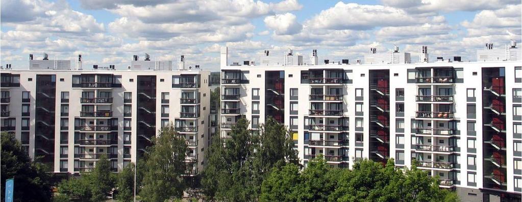
1 Travel Related Urban Zones in Finland Theory of Urban Fabrics Seminar in Helsinki, SYKE, Mika Ristimäki, Maija Tiitu, Ville Helminen, Panu Söderström, Kari Oinonen Finnish Environment Institute SYKE Built Environment Unit Hanna Kalenoja Tampere University of Technology


2 Built Environment Unit, Environmental Policy Centre, Finnish Environment Institute / SYKE


3 How do we support sustainability? Strengthening sustainable urban and rural forms - urban regions, spatial structure on city level and national level supporting strategic planning and integration of different land use needs - supporting regional planning, local master and detailed planning, assessment of land use policy and its planning instruments
4 Travel related urban zones in Finland
5 Travel related Urban Zone development work National application of the Urban Fabrics theory National reports (3) 1 / 3: Travel related urban zones in Finland. Including web besed atlas of 34 city regions in Finland: What has happened during the last 25 years? Publishing on tomorrow ( in Finnish) 2 / 3: A review of urban zone analyses in Finland. Why has happened and what will happen? Forthcoming 3 / 3: Guide for planners. How to use travel related urban zones in land use and transport planning, Forthcoming Case study reports: Publishing 3 / 2013 Vibrant Centres - Diversity and Quality of the urban Environment in the Regional City s centres. Panu Söderström, SY 32/2012 Helsinki Metropolitan region, Case study, Forthcoming Results has already been used in national land use policy, regional plans, urban regions, Helsinki Stockholm analysis etc. 5


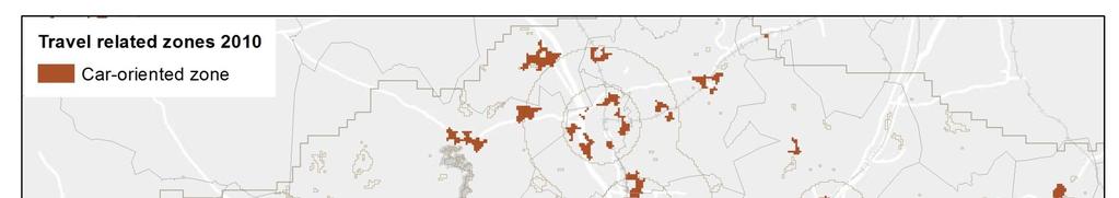
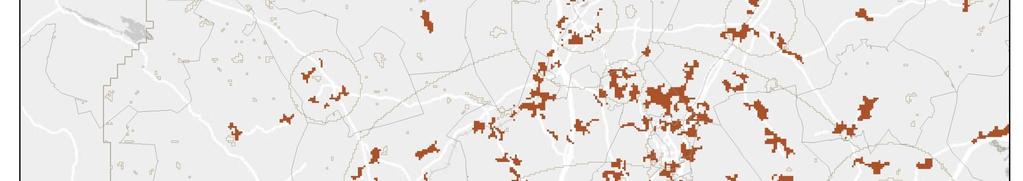
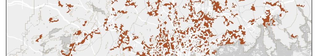
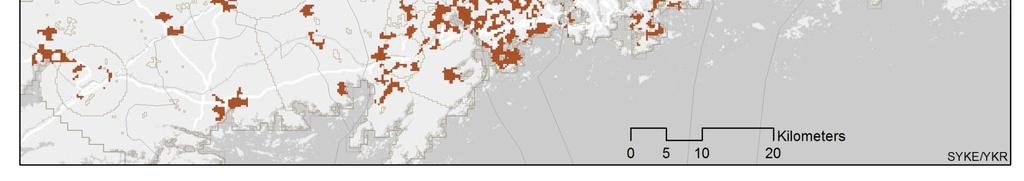
6 Criteria for the travel related urban zones Criteria is based on distance to CBD area distance to public transport stop headway of public transport location of subcentres 1. Pedestrian zone is limited in 1,0 2,0 km radius of CBD area 2. Pedestrian zone is surrounded by a fringe zone of the radius of 2-5 km of the pedestrian zone 3. In the large urban areas the subcentres form an independent pedestrian zone Public transport zones are on more than 2 km distance of the CBD area and there is high level of service of public transport. 1. Intensive public transport zone 2. Public transport zone The area outside the pedestrian and public transport zones is car-oriented zone. In large urban areas there is also some public transport supply in caroriented zones, but the public transport level of service is not as high as on other zones. In small urban areas, the public transport supply of car-oriented zones is modest.


7 Urban Zone area hierarchy Groups of urban regions Urban regions Distance-based areas Urban zones


8 Urban zones as a spatial dataset Zones are defined into a grid cells of 250 metres Time series 1985, 1990, 1995, 2000, 2005 and 2010 The grid is compatible with the national database of urban form and spatial structure (MUFFS data, Finnish Monitoring System of Urban Form and Spatial Structure) Public transport supply data and travel survey data can also be joined into the grid Photo: Maria Hyövälti 8
9 Peri-Urbanisation The peri-urban the space around urban areas which merges into the rural landscape is growing rapidly across Europe. There is about 48,000 km2 of built development in peri-urban areas, almost equal to that in urban areas. But while most urban areas are now slow growing (at % per year), built development in peri-urban areas is growing at four times this rate PLUREL project: Peri-urban Land Use Relationships Strategies and Sustainability Assessment Tools for Urban-Rural Linkages PLUREL is an Integrated Project funded within the 6th Research Framework Programme of the European Union in partners from 14 European countries and China => Peri-Urbanisation in Europe Synthesis Report 9


10 Groups of urban regions Inner urban Outer urban Peri-urban, rail-oriented Inner peri-urban Peri-urban, in Helsinki Region Outer Peri-urban Mid-sized urban regions along rail corridor Mid-sized urban regions along rail corridor, peri-urban Mid-sized urban regions, inner urban Mid-sized urban regions, peri-urban Small towns Areal division - urban, peri-urban and rural areas Rural areas Groups of urban regions Metropolitan region Large urban regions Mid-sized urban regions 1 Mid-sized urban regions 2 Small urban regions 1 Small urban regions 2 Mid-sized urban regions 2 Other areas 10

11 Helsinki functional urban region Inner urban Outer urban Peri-urban, rail corridor Inner peri-urban Outer peri-urban Mid-sized urban regions, rail corridor Mid-sized urban regions, rail corridor, peri-urban Mid-sized urban regions Mid-sized urban regions, peri-urban Small towns Rural areas Border of functional urban region 30 km

12 Helsinki functional urban region (FUR) in 1990 Intensive public transport zone Public transport zone Weak public transport zone Peri-Urbanisation Peri-urban development is the most rapid type of land use change in Europe In Helsinki peri-urban area the urban sprawl is one of the strongest in Europe Intensive public transport zone Public transport zone 12
13 Helsinki functional urban region (FUR) in 2010 Intensive public transport zone Public transport zone Weak public transport zone Peri-Urbanisation Peri-urban development is the most rapid type of land use change in Europe In Helsinki peri-urban area the urban sprawl is one of the strongest in Europe Intensive public transport zone Public transport zone 13
14 14

15 Polycentrism in the Helsinki Urban Region Tikkurila Myyrmäki Malmi Espoo C. Leppävaara Matinkylä Tapiola Pasila Central core

16 Larger mid-sized urban areas, 2010 Lähde: Urban Zone, SYKE / YKR, Mika Ristimäki

17 Development of the share of population on different zones Pedestrian zone Pedestrian zone of a subcentre Fringe of pedestrian zone Intensive public transport zone Public transport zone Car-oriented zone Other densely populated area Areas outside densely populated area 17
18 Development of average household size - all urban regions Inhabitants/household Pedestrian zone Pedestrian zone of a subcentre Pedestrian zone of a subcentre in peri-urban areas Fringe of pedestrian zone Intensive public transport zone Public transport zone, inner urban areas Public transport zone, periurban areas Car-oriented zone, inner urban areas Car-oriented zone, periurban areas Altogether 18


19 Car ownership in 2010 Households with no cars Car ownership Households with 2 or more cars pedestrian zone fringe of pedestrian zone fringe of pedestrian zone, core area fringe of pedestrian zone, peri-urban area intensive public transport zone public transport zone weak pulic transport zone car-oriented zone the border of core area 19

20 Helsinki metropolitan region: Zones where modal share of car was less than half of all weekday trips shorter than 100 km 20
21 In absolute numbers population has increased more in zones where people are able to live without car However, the relative change shows that car-oriented zone is growing faster Inhabitants % Zones where modal share of car is less than half Car-oriented zone % 21
22 20% is living in car-oriented zone Share of population Zones where modal share of car is less than half Car-oriented zone 22
23 Impact of Peri-Urbanisation on daily mileage (passenger km) for inhabitants Helsinki Urban Region Inner peri- Urban area, good rail connection Inner Peri Urban area Outer Peri- Urban area pedestrian zone fringe of pedestrian zone pedestrian zone of subcentre intensive public transport zone public transport zone car oriented zone pedestrian zone fringe of pedestrian zone intensive public transport zone public transport zone car oriented zone outside densely populated area pedestrian zone fringe of pedestrian zone intensive public transport zone public transport zone car oriented zone outside densely populated area pedestrian zone fringe of pedestrian zone public transport zone car oriented zone outside densely populated area passenger km/inhabitant, weekday 6,6 2,6 1,5 8,5 3,4. 1,7 11,6 10,6 14,4 18,1 16,7 21,5 20,7 4,6 5,2 2,5 2,1 4,5 29,6 23,9 31,2 26,9 28,9 24,9 23,3 31,9 30,1 30,1 33,2 31,3 1,8 4,4 1,6 8,8 1,6 8,5 6,6 1,2 5,9 6,4 1,7 6,0 5,2 3,2 5,4 3,6 4,3 3,7 2,5 4,5 37,1 3,6 35,4 3,3 walk bicycle car bus train tram metro
24 Carbon dioxide emissions of transport (g/inhabitants, weekday) HelsinkiUrban Region InnerPeri-Urban area, good rail connection InnerPeri-Urban area OuterPeri-Urban area pedestrian zone fringe of pedestrian zone pedestrian zone of subcentre intensive public transport zone public transport zone car oriented zone pedestrian zone fringe of pedestrian zone intensive public transport zone public transport zone car oriented zone outside densely populated area pedestrian zone fringe of pedestrian zone intensive public transport zone public transport zone car oriented zone outside densely populated area pedestrian zone fringe of pedestrian zone public transport zone car oriented zone outside densely populated area CO2grams/inhabitant, weekday

25 Development of urban form in Finland Urban form has at the same time fragmented and densified The share of population of car oriented zones and public transport zones has increased The area of car-oriented zone has increased by more than 50 % and the population in car-oriented zone by 36 % in The density of car-oriented zone has increased only in the metropolitan region The population in public transport zones have increased in large urban regions, but in small urban regions the public transport zone is almost non-existent The population density in the pedestrian zones have mainly increased, especially in large and mid-sized urban regions Photo: Tuula Palaste-Eerola
26 Urban zones into the information systems


27 How to Make Complicated Simple: Service Packets Regional planning & development Moving decisions Land use planning Transport planning Quality of environment Built cultural environment Flood risk information Eco-efficiency, energy


28 Thank you!
Developing harmonised indicators on urban public transport in Europe
 Developing harmonised indicators on urban public transport in Europe Hugo Poelman European Commission DG Regional and Urban GIS team Regional May 2015 context EU Cohesion European Regional Development
Urban-Rural spatial classification of Finland
 Urban-Rural spatial classification of Finland Finnish Environment Institute SYKE The geographical information-based area classification system has been created by the Finnish Environment Institute and
Tackling urban sprawl: towards a compact model of cities? David Ludlow University of the West of England (UWE) 19 June 2014
 19 June 2014") Tackling urban sprawl: towards a compact model of cities? David Ludlow University of the West of England (UWE) 19 June 2014 Impacts on Natural & Protected Areas why sprawl matters? Sprawl creates environmental,
Tackling urban sprawl: towards a compact model of cities? David Ludlow University of the West of England (UWE) 19 June 2014 Impacts on Natural & Protected Areas why sprawl matters? Sprawl creates environmental,
How the science of cities can help European policy makers: new analysis and perspectives
 How the science of cities can help European policy makers: new analysis and perspectives By Lewis Dijkstra, PhD Deputy Head of the Economic Analysis Unit, DG Regional and European Commission Overview Data
Workshop protocol Case Kuopio Raine Mäntysalo, Vesa Kanninen & Marco te Brömmelstroet
 Workshop protocol Case Kuopio Raine Mäntysalo, Vesa Kanninen & Marco te Brömmelstroet Centre for Urban and Regional Studies YTK Aalto University Introduction The implementation gap of the respective Planning
Transport Planning in Large Scale Housing Developments. David Knight
 Transport Planning in Large Scale Housing Developments David Knight Large Scale Housing Developments No longer creating great urban spaces in the UK (Hall 2014) Transport Planning Transport planning processes
Transit-Oriented Development. Christoffer Weckström
 Transit-Oriented Development Christoffer Weckström 31.10.2017 Outline Context of Transit-oriented Development Elements of Transit-oriented Development A short history of land use and transit integration
Regional Plan 4: Integrating Ecosystem Services Mapping into Regional Land Use Planning
 Rural-Urban Outlooks: Unlocking Synergies (ROBUST) ROBUST receives funding from the European Union s Horizon 2020 research and innovation programme under grant agreement No 727988.* October 2018 Natural
Effects of a non-motorized transport infrastructure development in the Bucharest metropolitan area
 The Sustainable City IV: Urban Regeneration and Sustainability 589 Effects of a non-motorized transport infrastructure development in the Bucharest metropolitan area M. Popa, S. Raicu, D. Costescu & F.
Figure 10. Travel time accessibility for heavy trucks
 Figure 10. Travel time accessibility for heavy trucks Heavy truck travel time from Rotterdam to each European cities respecting the prescribed speed in France on the different networks - Road, motorway
Urban development in Finland part of a dynamic or declining Europe?
 Urban development in Finland part of a dynamic or declining Europe? Emma Terämä Finnish environment institute (SYKE) URMI 2.2.2017 Tampere 1 Maija Mattinen Emma Terämä Ville Helminen Urban Europe vs. Finland
The Spatial Structure of Cities: International Examples of the Interaction of Government, Topography and Markets
 Module 2: Spatial Analysis and Urban Land Planning The Spatial Structure of Cities: International Examples of the Interaction of Government, Topography and Markets Alain Bertaud Urbanist Summary What are
Vincent Goodstadt. Head of European Affairs METREX European Network
 Vincent Goodstadt Head of European Affairs METREX European Network METREX (Network of 50 European Metropolitan Regions and Areas ) Exchanging Knowledge (e.g. Benchmarking) Climate Change CO2/80/50 Expertise
Why care about metropolitan and regional perspectives?
 Metropolitan challenges and solutions Why care about metropolitan and regional perspectives? Irma Karjalainen, Director, Helsinki Region Environmental Services Authority HSY, LUMAT Conference, 25 September
Levels of spatial planning, Preparatory Land Use Plan, Sustainable Development. The Stuttgart Example
 Levels of spatial planning, Preparatory Land Use Plan, Sustainable Development. The Stuttgart Example Dipl.-Ing. Robert Schulze Dieckhoff Urban Planner Department of City Planning and Urban Renewal State
The ESPON Programme. Goals Main Results Future
 The ESPON Programme Goals Main Results Future Structure 1. Goals Objectives and expectations Participation, organisation and networking Themes addressed in the applied research undertaken in ESPON projects
TRACC Transport Accessibility at Regional/Local Scale and Patterns in Europe
 TRACC Transport Accessibility at Regional/Local Scale and Patterns in Europe Applied Research 2013/1/10 Final Report Version 30/06/2013 Volume 3 TRACC Regional Case Study Book Part G Finland case study
European spatial policy and regionalised approaches
 Findings of the ESPON 2006 Programme COMMIN Final Conference 26-27 April 2007 European spatial policy and regionalised approaches by Dr. Kai BöhmeB ! Territory matters Structure of presentation! Territorial
Making maps: Traditions and perceptions in Europe. European spatial planning and cartographic representations
 ESPON Create Europe! Making maps: Traditions and perceptions in Europe Dr. Stefanie Dühr University of the West of England, Bristol, UK European spatial planning and cartographic representations Scenarios.
accessibility instruments in planning practice
 accessibility instruments in planning practice Spatial Network Analysis for Multi-Modal Transport Systems (SNAMUTS): Helsinki Prof Carey Curtis, Dr Jan Scheurer, Curtin University, Perth - RMIT University,
Assessing spatial distribution and variability of destinations in inner-city Sydney from travel diary and smartphone location data
 Assessing spatial distribution and variability of destinations in inner-city Sydney from travel diary and smartphone location data Richard B. Ellison 1, Adrian B. Ellison 1 and Stephen P. Greaves 1 1 Institute
Knowledge claims in planning documents on land use and transport infrastructure impacts
 Knowledge claims in planning documents on land use and transport infrastructure impacts Presentation at the Final Workshop of the research project "Innovations for sustainable public transport in Nordic
IGCSE Geography Unit 2: Types of Settlement
 IGCSE Geography Unit 2: Types of Settlement Recommended Prior Knowledge An understanding of the factors that affect the nature, location, growth and structure of settlements. A good general knowledge,
Key Indicators for Territorial Cohesion and Spatial Planning in Preparing Territorial Development Strategies
 ESPON Evidence in a North European Context Challenges and Opportunities for Territorial Development and Cohesion in a North European Macro Region, 10-11 April, 2014, Vilnius, Lithuania Key Indicators for
Travel behavior of low-income residents: Studying two contrasting locations in the city of Chennai, India
 Travel behavior of low-income residents: Studying two contrasting locations in the city of Chennai, India Sumeeta Srinivasan Peter Rogers TRB Annual Meet, Washington D.C. January 2003 Environmental Systems,
True Smart and Green City? 8th Conference of the International Forum on Urbanism
 ,, doi:10.3390/ifou-. True Smart and Green City? 8th Conference of the International Forum on Urbanism Conference Proceedings Paper Comparable Measures of Accessibility to Public Transport by the General
Note on Transportation and Urban Spatial Structure
 Note on Transportation and Urban Spatial Structure 1 By Alain Bertaud, Washington, ABCDE conference, April 2002 Email: duatreb@msn.com Web site: http://alain-bertaud.com/ http://alainbertaud.com/ The physical
Urban Form and Travel Behavior:
 Urban Form and Travel Behavior: Experience from a Nordic Context! Presentation at the World Symposium on Transport and Land Use Research (WSTLUR), July 28, 2011 in Whistler, Canada! Petter Næss! Professor
GIS, Maps and Spatial Analyses in Urban Planning
 GIS, Maps and Spatial Analyses in Urban Planning LOOM.02.331 ANTO AASA PhD, researcher Power of visualization: What s this? Economic spaces in Europe (chorems based approach) Europe economy 1646 General:
California Urban Infill Trip Generation Study. Jim Daisa, P.E.
 California Urban Infill Trip Generation Study Jim Daisa, P.E. What We Did in the Study Develop trip generation rates for land uses in urban areas of California Establish a California urban land use trip
Urban Planning Word Search Level 1
 Urban Planning Word Search Level 1 B C P U E C O S Y S T E M P A R E U O E U R B A N P L A N N E R T N S T D H E C O U N T Y G E R E R D W R E N I C I T Y C O U N C I L A A A S U G G C I L A G P R I R
How is public transport performing in Australia
 How is public transport performing in Australia CILTA Moving People Thursday 17 March 2011 Professor Corinne Mulley Institute of Transport and Logistics Studies Outline Measuring performance Australia
Module 3 Indicator Land Consumption Rate to Population Growth Rate
 Regional Training Workshop on Human Settlement Indicators Module 3 Indicator 11.3.1 Land Consumption Rate to Population Growth Rate Dennis Mwaniki Global Urban Observatory, Research and Capacity Development
Accessibility patterns: Bavaria Case Study 1
 EUROPA XXI Vol. 24, 2013, pp. 49-59 http://dx.doi.org/10.7163/eu21.2013.24.4 Institute of Geography and Spatial Organization Polish Academy of Sciences www.igipz.pan.pl Accessibility patterns: Bavaria
Poland, European Territory, ESPON Programme Warsaw, 2 July 2007 STRATEGY OF THE ESPON 2013 PROGRAMME
 Poland, European Territory, ESPON Programme 2007-2013 Warsaw, 2 July 2007 STRATEGY OF THE ESPON 2013 PROGRAMME Territory matters Regional diversity as asset Territorial potentials increasing in importance
The European territory: Strategic developmentd
 The European territory: Strategic developmentd Peter Mehlbye Workshop Strategic Development Catalonia 11 June 2002 THE LECTURE Structure I. Territorial trends II. Strategy for European spatial development
Lombardy Region Territorial Context and Planning Structures
 Lombardy Region Territorial Context and Planning Structures Carlo Palazzoli RUMORE project manager carlo_palazzoli@regione.lombardia.it 15th May 2018 / RUMORE Third Partner Meeting Lombardy Region in Europe
Accessibility Instruments in Planning Practice Spatial Network Analysis for Multi-Modal Transport Systems (SNAMUTS): Adelaide
: Adelaide") Accessibility Instruments in Planning Practice Spatial Network Analysis for Multi-Modal Transport Systems (SNAMUTS): Adelaide Prof Carey Curtis, Dr Jan Scheurer, Roger Mellor, Oscar Thomson Curtin University,
Accessibility Instruments in Planning Practice Spatial Network Analysis for Multi-Modal Transport Systems (SNAMUTS): Adelaide Prof Carey Curtis, Dr Jan Scheurer, Roger Mellor, Oscar Thomson Curtin University,
Enhancing indicators on urban public transport in combination with geostatistics
 Enhancing indicators on urban public transport in combination with geostatistics Hugo Poelman European Commission DG and Urban GIS team April 2015 Harmonised indicators on European cities? EU-OECD definition
Intra-metropolitan polycentricity in practice
 Intra-metropolitan polycentricity in practice Results from our questionnaire survey - 11 metropolitan areas Naples, Mazovia, Frankfurt/Rhein-Main, Veneto, Paris, Rotterdam, Helsinki, Emilia-Romagna, Tri-City,
Towards indicators of proximity to services in Europe's major cities
 Towards indicators of proximity to services in Europe's major cities Enhancing the analytical use of the GMES Urban Atlas in combination with population distribution data Hugo Poelman European Commission
Spatio-temporal dynamics of the urban fringe landscapes
 Spatio-temporal dynamics of the urban fringe landscapes Yulia Grinblat 1, 2 1 The Porter School of Environmental Studies, Tel Aviv University 2 Department of Geography and Human Environment, Tel Aviv University
GIS Analysis of Crenshaw/LAX Line
 PDD 631 Geographic Information Systems for Public Policy, Planning & Development GIS Analysis of Crenshaw/LAX Line Biying Zhao 6679361256 Professor Barry Waite and Bonnie Shrewsbury May 12 th, 2015 Introduction
Third Cohesion report February 2004
 February 2004 A new partnership for cohesion Convergence, Competitiveness and Co-operation METREX meeting S. Sebastian, Luisa Sanches DG REGIO The 3rd CR structure 1. Analysis of situation and trends in
Vienna urban development - seestadt aspern as urban future lab
 Vienna urban development - seestadt aspern as urban future lab PERMACULTURE DESIGN COURSE * 2012 * ASPERN SEESTADT 1 Christof Schremmer, ÖIR Austrian Institute for Regional Studies and Spatial Planning
National planning report for Denmark
 National planning report for Denmark from the Minister for Environment and Energy Local identity and new challenges Summary 2000 1 CONTENTS 4 PREFACE: REGIONAL DEVELOPMENT AND SPATIAL PLANNING 6 1. BALANCED
Forecasts from the Strategy Planning Model
 Forecasts from the Strategy Planning Model Appendix A A12.1 As reported in Chapter 4, we used the Greater Manchester Strategy Planning Model (SPM) to test our long-term transport strategy. A12.2 The origins
IMPACT OF CONCENTRATION OF URBAN ACTIVITIES ON TRANSPORT; COMPARATIVE ANALYSIS BETWEEN DUTCH AND JAPANESE CITIES
 IMPACT OF CONCENTRATION OF URBAN ACTIVITIES ON TRANSPORT; COMPARATIVE ANALYSIS BETWEEN DUTCH AND JAPANESE CITIES Cees D. van Goeverden Delft University of Technology, Transport and Planning Section Nobuaki
Densification as key strategy in urban development
 Densification as key strategy in urban development 1 Christof Schremmer, ÖIR Austrian Institute for Regional Studies and Spatial Planning ökosan 15, Graz, June 18, 2015 Spatial features Urban structure
Governance approaches to ruralurban partnerships: a functional perspective to policy making
 Governance approaches to ruralurban partnerships: a functional perspective to policy making web page: www.oecd.org/regional/rurban Paolo Veneri Regional Development Policy Division GOV OECD Warsaw, 24
Urban-rural relations in Europe
 Urban-rural relations in Europe Typology of urban and rural characteristics developed by the ESPON 1.1.2 project Kaisa Schmidt-Thomé 14.12.2006 Sevilla JRC/IPTS Rural typologies -workshop ESPON 2006 Programme
Compact guides GISCO. Geographic information system of the Commission
 Compact guides GISCO Geographic information system of the Commission What is GISCO? GISCO, the Geographic Information System of the COmmission, is a permanent service of Eurostat that fulfils the requirements
THE LEGACY OF DUBLIN S HOUSING BOOM AND THE IMPACT ON COMMUTING
 Proceedings ITRN2014 4-5th September, Caulfield and Ahern: The Legacy of Dublin s housing boom and the impact on commuting THE LEGACY OF DUBLIN S HOUSING BOOM AND THE IMPACT ON COMMUTING Brian Caulfield
Land Use in the context of sustainable, smart and inclusive growth
 Land Use in the context of sustainable, smart and inclusive growth François Salgé Ministry of sustainable development France facilitator EUROGI vice president AFIGéO board member 1 Introduction e-content+
Alps Results from the ESPON Project. Common spatial perspectives for the Alpine area. Towards a common vision
 Results from the ESPON Project Alps 2050 Common spatial perspectives for the Alpine area. Towards a common vision Tobias Chilla, University of Erlangen Cooperation Alps 2020+ 1 & 2 October 2018 Salzburg
Development of modal split modeling for Chennai
 IJMTES International Journal of Modern Trends in Engineering and Science ISSN: 8- Development of modal split modeling for Chennai Mr.S.Loganayagan Dr.G.Umadevi (Department of Civil Engineering, Bannari
ESPON support for Targeted Analyses Ilona Raugze Director
 ESPON support for Targeted Analyses Ilona Raugze Director ESPON EGTC 14 November 2017 ESPON EGTC workshop Targeted Analysis in support of better policy making in cities and regions Inspire policy making
Shall we Dense?: Policy Potentials. Summary. Simon McPherson Director SJB Urban Australia au
 Shall we dense? Shall we Dense?: Policy Potentials Simon McPherson Director SJB Urban Australia smcpherson@sjb.com. au Adam Haddow Director SJB Architects Australia ahaddow@sjb.com.au Summary This paper
CREATING LIVEABLE & SAFE CITIES FOR ALL
 CREATING LIVEABLE & SAFE CITIES FOR ALL Taking Transit to people s door steps PRERNA V. MEHTA, MANAGER, WRI INDIA RAJEEV G. MALAGI, SR. PROJECT ASSOCIATE, WRI INDIA A product of WRI Ross Center for Sustainable
REGIONAL LAND USE PLAN. Joint master plan LOCAL MASTER PLAN. - Prepared and approved by local authority
 Information systems for monitoring land use planning in the Finnish Environmental Administration. GISALU (Land Use GIS) and KATSE (the Information System for Monitoring Land Use Planning). M.Sc. (Tech.)
Abstract. 1 Introduction
 Urban density and car and bus use in Edinburgh Paul Dandy Department of Civil & Transportation Engineering, Napier University, EH10 5DT, United Kingdom EMail: p.dandy@napier.ac.uk Abstract Laissez-faire
accessibility accessibility by-pass bid-rent curve bridging point administrative centre How easy or difficult a place is to reach.
 accessibility accessibility How easy or difficult a place is to reach. How easy or difficult it is to enter a building. administrative centre bid-rent curve The function of a town which is a centre for
Improving rural statistics. Defining rural territories and key indicators of rural development
 Improving rural statistics Defining rural territories and key indicators of rural development Improving rural statistics Improving Rural Statistics In 2016, the Global Strategy to improve Agricultural
Developing a global, peoplebased definition of cities and settlements
 Developing a global, peoplebased definition of cities and settlements By Lewis Dijkstra, Lewis.Dijkstra@ec.europa.eu Head of the Economic Analysis Sector DG for Regional and Urban Policy, Regional & Urban
ARCH PROJET Activity 1 -Synthesis-
 ARCH PROJET Activity 1 -Synthesis- CONTENT 1 ARCH project context... 3 1.1. General context... 3 1.2. The ARCH Project... 3 1.3. The Project ARCH partners... 3 1.4. The ARCH project content... 4 2 Activity
Eco-social Impacts of Second Home Tourism in Rural Finland
 FUNTS Eco-social Impacts of Second Home Tourism in Rural Finland The XXIII ESRS Congress Vaasa, Finland 17-21 August 2009 Mervi J. Hiltunen & Mia Vepsäläinen Centre for Tourism Studies University of Joensuu
CORRIDORS OF FREEDOM Access Management (Ability) Herman Pienaar: Director City Transformation and Spatial Planning
 Herman Pienaar: Director City Transformation and Spatial Planning") CORRIDORS OF FREEDOM Access Management (Ability) 2016 Herman Pienaar: Director City Transformation and Spatial Planning PLANNING DEVELOPMENT PROCESS RATHER THAN A PLAN CAPITAL INVESTMENT DEVELOPMENT FACILITATION
CORRIDORS OF FREEDOM Access Management (Ability) 2016 Herman Pienaar: Director City Transformation and Spatial Planning PLANNING DEVELOPMENT PROCESS RATHER THAN A PLAN CAPITAL INVESTMENT DEVELOPMENT FACILITATION
Examining the Potential Travellers in Catchment Areas for Public Transport
 Examining the Potential Travellers in Catchment Areas for Public Transport Alex Landex Research Assistant, M.Sc. Centre for Traffic and Transport (CTT) Technical University of Denmark (DTU) Bygningstorvet,
Johannes Suitner Department of Spatial Planning, TU Wien Polycentricity at different scales
 Johannes Suitner Department of Spatial Planning, TU Wien Polycentricity at different scales ESPON Seminar Territory matters: Keeping Europe and its regions competitive 16-17 June 2016 @ Marine Etablissement
BeMInE consortium project
 BeMInE consortium project www.bemine.fi Project presentation 9.9.2016 Raine Mäntysalo 1 2 Hypothesis The current MALPE work has several problems that hinder it from gaining strategic and integrative foresight
Urban and rural poles in positive interrelations
 Urban and rural poles in positive interrelations A stake for a better cohesion of the European continent Gérard Peltre president of the international association Rurality-Environment-Development (R.E.D.)
Managing Growth: Integrating Land Use & Transportation Planning
 Managing Growth: Integrating Land Use & Transportation Planning Metro Vancouver Sustainability Community Breakfast Andrew Curran Manager, Strategy June 12, 2013 2 Integrating Land Use & Transportation
Mapping Accessibility Over Time
 Journal of Maps, 2006, 76-87 Mapping Accessibility Over Time AHMED EL-GENEIDY and DAVID LEVINSON University of Minnesota, 500 Pillsbury Drive S.E., Minneapolis, MN 55455, USA; geneidy@umn.edu (Received
C) Discuss two factors that are contributing to the rapid geographical shifts in urbanization on a global scale.
 Discuss two factors that are contributing to the rapid geographical shifts in urbanization on a global scale.") AP Human Geography Unit VII. Cities and Urban Land Use Free Response Questions FRQ 1 Rapid urbanization in Least Developed Countries (LDCs) has many profound impacts for the world. Answer the following
AP Human Geography Unit VII. Cities and Urban Land Use Free Response Questions FRQ 1 Rapid urbanization in Least Developed Countries (LDCs) has many profound impacts for the world. Answer the following
Workshop B Spatial positioning and definition of characteristics
 This presentation expresses the author's views. It does not necessarily reflect the opinion of the ESPON Monitoring Committee, which is not liable for any use that may be made of the information provided.
Developing Quality of Life and Urban- Rural Interactions in BSR
 Developing Quality of Life and Urban- Rural Interactions in BSR Sakari Saarinen Union of the Baltic Cities, Commission on Environment Seminar on Quality of Life in Small Communities, 27 May 2010, Kärdla,
RURAL-URBAN PARTNERSHIPS: AN INTEGRATED APPROACH TO ECONOMIC DEVELOPMENT
 RURAL-URBAN PARTNERSHIPS: AN INTEGRATED APPROACH TO ECONOMIC DEVELOPMENT William Tompson Head of the Urban Development Programme OECD Public Governance and Territorial Development Directorate JAHRESTAGUNG
Developing a global, people-based definition of cities and settlements
 Developing a global, people-based definition of cities and settlements Cooperation between: Directorate General for Regional and, Joint Research Centre, EUROSTAT (European Commission, European Union) OECD,
What do we think of our cities?
 What do we think of our cities? Do we think of cities as beautiful places? Are cities healthy places to live? Do most of the world s people live in cities? Do cities function like other natural systems,
Urban green growth strategies
 Urban green growth strategies Rolf lfalter Director Public Governance and Territorial Development Future City Initiatives International Forum Plenary Session 16 February, 2013 (Shimokawa) 1 Why are cities
The National Spatial Strategy
 Purpose of this Consultation Paper This paper seeks the views of a wide range of bodies, interests and members of the public on the issues which the National Spatial Strategy should address. These views
A Review of Concept of Peri-urban Area & Its Identification
 A Review of Concept of Peri-urban Area & Its Identification Ar. Manita Saxena Research Scholar Department of Architecture and Planning M.A.N.I.T, Bhopal Dr. Supriya Vyas Assistant Professor, Department
It is clearly necessary to introduce some of the difficulties of defining rural and
 UNIT 2 CHANGING HUMAN ENVIRONMENTS G2 Theme 2 Investigating Settlement Change in MEDCs 2.1 What are the distinctive features of settlements? It is clearly necessary to introduce some of the difficulties
Operational Definitions of Urban, Rural and Urban Agglomeration for Monitoring Human Settlements
 Operational Definitions of Urban, Rural and Urban Agglomeration for Monitoring Human Settlements By Markandey Rai United Nations Human Settlements Programme PO Box-30030 Nairobi, Kenya Abstract The United
Interactive Visualization Tool (InViTo)
") Interactive Visualization Tool (InViTo) Stefano Pensa To cite this report: Stefano Pensa (2012) Interactive Visualization Tool (InViTo), in Angela Hull, Cecília Silva and Luca Bertolini (Eds.) Accessibility
Interactive Visualization Tool (InViTo) Stefano Pensa To cite this report: Stefano Pensa (2012) Interactive Visualization Tool (InViTo), in Angela Hull, Cecília Silva and Luca Bertolini (Eds.) Accessibility
Foreword. Vision and Strategy
 GREATER MANCHESTER SPATIAL FRAMEWORK Friends of Walkden Station Consultation Response January 2017 Foreword Friends of Walkden Station are a group of dedicated volunteers seeking to raise the status and
Economic and Social Urban Indicators: A Spatial Decision Support System for Chicago Area Transportation Planning
 Economic and Social Urban Indicators: A Spatial Decision Support System for Chicago Area Transportation Planning Piyushimita Thakuriah (Vonu), P.S. Sriraj, Paul Metaxatos, Inshu Minocha & Tanushri Swarup
Agglomeration Programme Switzerland: Integrated Planning by Balancing Transport and Urban Development IFHP Congress, Singapore
 Agglomeration Programme Switzerland: Integrated Planning by Balancing Transport and Urban Development IFHP Congress, Singapore May 30, 2014 Susanne Fischer, Head of Regional Planning, Department of Public
Hennig, B.D. and Dorling, D. (2014) Mapping Inequalities in London, Bulletin of the Society of Cartographers, 47, 1&2,
 Mapping Inequalities in London, Bulletin of the Society of Cartographers, 47, 1&2,") Hennig, B.D. and Dorling, D. (2014) Mapping Inequalities in London, Bulletin of the Society of Cartographers, 47, 1&2, 21-28. Pre- publication draft without figures Mapping London using cartograms The
Hennig, B.D. and Dorling, D. (2014) Mapping Inequalities in London, Bulletin of the Society of Cartographers, 47, 1&2, 21-28. Pre- publication draft without figures Mapping London using cartograms The
Interregional Cooperation in the Apennines
 INTERNATIONAL WORKSHOP THE ALPS AND THE ARDENNES: SHARING EXPERIENCES AMONG TRANSBOUNDARY MOUNTAIN AREAS Interregional Cooperation in the Apennines Massimo Sargolini, professor at the University of Camerino,
Simulating Mobility in Cities: A System Dynamics Approach to Explore Feedback Structures in Transportation Modelling
 Simulating Mobility in Cities: A System Dynamics Approach to Explore Feedback Structures in Transportation Modelling Dipl.-Ing. Alexander Moser [amoser@student.tugraz.at] IVT Tagung 2013 - Kloster Kappel
The 3V Approach. Transforming the Urban Space through Transit Oriented Development. Gerald Ollivier Transport Cluster Leader World Bank Hub Singapore
 Transforming the Urban Space through Transit Oriented Development The 3V Approach Gerald Ollivier Transport Cluster Leader World Bank Hub Singapore MDTF on Sustainable Urbanization The China-World Bank
STILLORGAN QBC LEVEL OF SERVICE ANALYSIS
 4-5th September, STILLORGAN QBC LEVEL OF SERVICE ANALYSIS Mr David O Connor Lecturer Dublin Institute of Technology Mr Philip Kavanagh Graduate Planner Dublin Institute of Technology Abstract Previous
National Spatial Development Perspective (NSDP) Policy Coordination and Advisory Service
 Policy Coordination and Advisory Service") National Spatial Development Perspective (NSDP) Policy Coordination and Advisory Service 1 BACKGROUND The advances made in the First Decade by far supersede the weaknesses. Yet, if all indicators were
National Spatial Development Perspective (NSDP) Policy Coordination and Advisory Service 1 BACKGROUND The advances made in the First Decade by far supersede the weaknesses. Yet, if all indicators were
Sharthi Laldaparsad Statistics South Africa, Policy Research & Analysis. Sub-regional workshop on integration of administrative data,
 Sub-regional workshop on integration of administrative data, big data and geospatial information for the compilation of SDG indicators and International Workshop on Global Fundamental Geospatial Data Themes
Date: June 19, 2013 Meeting Date: July 5, Consideration of the City of Vancouver s Regional Context Statement
 Section E 1.5 To: From: Regional Planning and Agriculture Committee Lee-Ann Garnett, Senior Regional Planner Planning, Policy and Environment Department Date: June 19, 2013 Meeting Date: July 5, 2013 Subject:
Spatial Planning & Climate Change
 Spatial Planning & Climate Change A GRIP Approach Joseph Scott, Glasgow & Clyde Valley Strategic Development Plan Authority, Scotland Today s presentation Context Spatial Planning & Climate Change Exploring
Challenges for the European Territory
 IX European Biennial of Towns and Town Planners 15 September 2011 in Genoa Challenges for the European Territory Peter Mehlbye Structure of Intervention Content What Major Challenges, Structures and Dynamics
Global City Definition
 Regional Training Workshop on Human Settlement Indicators Global City Definition Dennis Mwaniki Global Urban Observatory, Research and Capacity Development Branch, UN-Habitat Bangkok, Thailand Outline
City definitions. Sara Ben Amer. PhD Student Climate Change and Sustainable Development Group Systems Analysis Division
 City definitions Sara Ben Amer PhD Student Climate Change and Sustainable Development Group Systems Analysis Division sbea@dtu.dk Contents 1. Concept of a city 2. Need for the city definition? 3. Challenges