Workshop protocol Case Kuopio Raine Mäntysalo, Vesa Kanninen & Marco te Brömmelstroet
|
|
|
- Annabella Poole
- 6 years ago
- Views:
Transcription
1 Workshop protocol Case Kuopio Raine Mäntysalo, Vesa Kanninen & Marco te Brömmelstroet Centre for Urban and Regional Studies YTK Aalto University
2 Introduction The implementation gap of the respective Planning Support Systems (LUT PSS) between theory and practice. In Finland, the Kuopio Three Urban Fabrics Model has created a successful local platform for communication between the different fields of planning and design, and related political decision making, and has thus functioned as a transdiscursive planning tool. The Kuopio case has been studied using a theoretical concept trading zone, developed by Peter Galison in the field of social studies of science and technology. The analysis suggests that the success of an integrative LUT planning instrument depends on the degree to which it is able to generate a local communicative platform, a narrowed down pidgin language between the different planning perspectives (e.g. land use and tranportation planning).
3 Trading zone Peter Galison (1997): Image and Logic. A Material Culture of Microphysics While the concept has been well established in the field of sociological studies of science and technology, its applicability in the realms of environmental planning and policy-making has been gaining increasing interest. Trading zone refers to infrastructures and concepts that function as exchange languages for the mutual out-talk between members of different sub-cultures. A platform where highly elaborate and complicated issues can be transformed into thin descriptions for the purposes of exchanging information in a certain locality. Originally developed to describe inter-cultural coordination between different groups of scientists (e.g. theorists, empiricists and instrumentalists in microphysics) Analogy to anthropological linguistics studies of pidgin and creole languages Related to the boundary object concept (Star & Griesemer 1989) but more dynamic.
4 The Kuopio Three Urban Fabrics Model Developed by the city planner Leo Kosonen and his colleagues locally in the city of Kuopio ( inhabitants), in eastern Finland, during the last 20 years. Motivated by the need to manage the urban growth of Kuopio with means that would have better responsiveness to problems of urban sprawl and increasing car-based mobility. The core idea of the model is a radically simplified conception of the urban system (inspired especially by Newman & Kenworthy): Walking City Transit City Car City

5 The Kuopio Three Urban Fabrics Model Transit city as a string of pearls with elaborated guidelines for both strategic and detailed land use planning as well as transportation network planning and detailed street design.
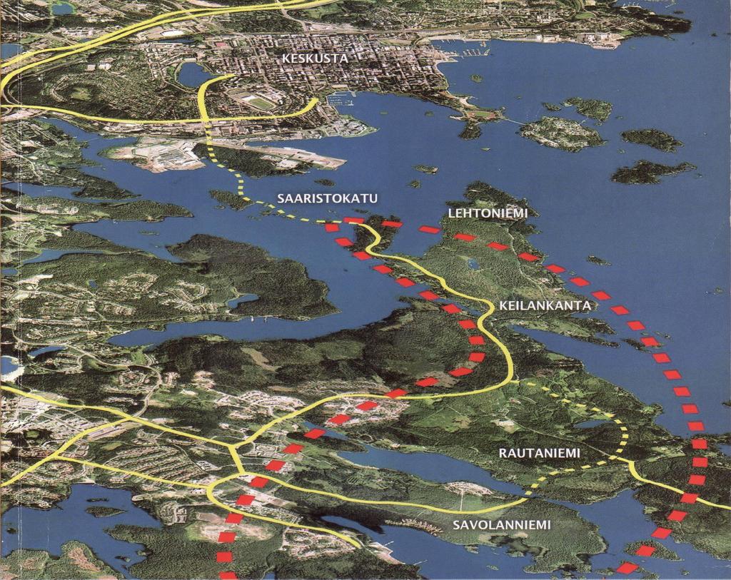
6 Saaristokatu Project
7 The generation of the Kuopio Three Urban Fabrics Model a trading zone A thin description of the urban system for the mutual coordination of planning between the different sectors of public planning and administration The model resonates with the citizens everyday experience of the functioning of the city. Therefore the local lay politicians can rather easily grasp the planning principles fostering balance between the different city types - that the model portrays. Transit City Walking City During the evolution of the model, new elements and actor groups have been integrated and new more sophisticated tools of planning and analysis have been developed. Car City

8 Research project: Car-dependent urban structure & its alternatives The Three Urban Fabrics Model developed into a GISbased urban planning tool in cooperation with local planners Walking City Transit City Car City
: developmental analyses and comparisons between regions Comparative knowledge (in time and location) of urban structure: housing, jobs, services, greenery and")
9 YKR: The data system for analysing and monitoring the development urban and regional structure GIS-based data utilizing data from Statistics Finland Independent of municipal boundaries Information of long term trends (since 1980): developmental analyses and comparisons between regions Comparative knowledge (in time and location) of urban structure: housing, jobs, services, greenery and connections between them Basic tool for monitoring, analysing and planning
10
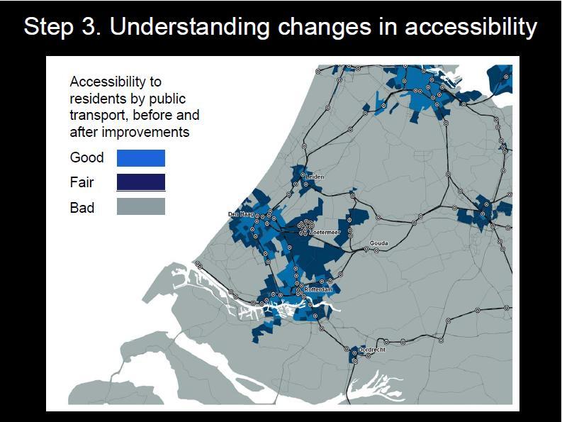
11

12
13
14 Planning goals in Kuopio Three Urban Fabrics Model Balancing different modes of mobility and counter-acting the expansion of the Car City and related car dependency Steering urban growth on the basis of Transit City growth fingers Increasing the attractiveness of the city centre on the basis of Walking City Walking City Transit City Car City
15

16
: outer suburbs along bus route strings, with housing pearls surrounding bus stop nodes within 250 m distance, bus")
17 Accessibility measures in Kuopio Walking City Zone 1 (blue): the commercial centre and surroundings within a 1 km circle, pedestrian grid Zone 2 (green): inner suburbs within a 1 km distance to Zone 1, with good pedestrian and bicycle routes to the centre Transit City Zone 3 (red): outer suburbs along bus route strings, with housing pearls surrounding bus stop nodes within 250 m distance, bus frequency min Car City - Zone 4 (yellow): other outer suburbs
18

19 Understanding changes in accessibility in Kuopio Share of inhabitants living in areas with density of min. 20 res./ha,

20 Understanding changes in accessibility in Kuopio Share of inhabitants living and/or working in car dependent zones,

21 Understanding changes in accessibility in Kuopio Average distance to nearest grocery store in different mobility zones,
22 Population in different mobility zones,
23 Population density (res./ha) in different mobility zones,
24 Amount of jobs in different mobility zones,
25

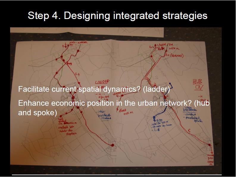
26 Designing integrated strategies in Kuopio The Three Urban Fabrics Model adopted as a framework for other sectors of administration, too. The statistical district data and mobility surveys arranged accordingly. Adopted in different policy and planning measures, e.g. Kuopio Architectural Policy, the Healthy City Programme. Key projects: Saaristokatu, City centre pedestrian street grid Greatest challenge: Out-of-town shopping centre projects (e.g. Ikea-Ikano)
Travel Related Urban Zones in Finland
 Travel Related Urban Zones in Finland Theory of Urban Fabrics Seminar in Helsinki, SYKE, 24.10.2013 Mika Ristimäki, Maija Tiitu, Ville Helminen, Panu Söderström, Kari Oinonen Finnish Environment Institute
Declaration Population and culture
 Declaration Population and culture The ministers of the parties to the Alpine Convention regard the socio-economic and socio-cultural aspects mentioned in Article 2, Paragraph 2, Item a., as being central
National planning report for Denmark
 National planning report for Denmark from the Minister for Environment and Energy Local identity and new challenges Summary 2000 1 CONTENTS 4 PREFACE: REGIONAL DEVELOPMENT AND SPATIAL PLANNING 6 1. BALANCED
Riga. Riga City Planning Region. Legal framework
 Riga http://www.rpr.gov.lv/ Riga City Planning Region Riga Planning Region as a territory is situated in the central part of Latvia, and its centre is Riga - the capital of Latvia. Riga is internationally
Land Use Planning and Agriculture: Austrian Experiences and Challenges I
 Land Use Planning and Agriculture: Austrian Experiences and Challenges I SULANET Summer School 2016 Walter Seher BOKU Vienna 1 Land Use Planning and Agriculture 2 Land Use Planning and Agriculture Agriculture
BeMInE consortium project
 BeMInE consortium project www.bemine.fi Project presentation 9.9.2016 Raine Mäntysalo 1 2 Hypothesis The current MALPE work has several problems that hinder it from gaining strategic and integrative foresight
Land Use in the context of sustainable, smart and inclusive growth
 Land Use in the context of sustainable, smart and inclusive growth François Salgé Ministry of sustainable development France facilitator EUROGI vice president AFIGéO board member 1 Introduction e-content+
CREATING LIVEABLE & SAFE CITIES FOR ALL
 CREATING LIVEABLE & SAFE CITIES FOR ALL Taking Transit to people s door steps PRERNA V. MEHTA, MANAGER, WRI INDIA RAJEEV G. MALAGI, SR. PROJECT ASSOCIATE, WRI INDIA A product of WRI Ross Center for Sustainable
GIS Geographical Information Systems. GIS Management
 GIS Geographical Information Systems GIS Management Difficulties on establishing a GIS Funding GIS Determining Project Standards Data Gathering Map Development Recruiting GIS Professionals Educating Staff
Urban Form and Travel Behavior:
 Urban Form and Travel Behavior: Experience from a Nordic Context! Presentation at the World Symposium on Transport and Land Use Research (WSTLUR), July 28, 2011 in Whistler, Canada! Petter Næss! Professor
Sustainable Development Goal 11 and the New Urban Agenda: can planning deliver? Vanessa Watson University of Cape Town 2016
 Sustainable Development Goal 11 and the New Urban Agenda: can planning deliver? Vanessa Watson University of Cape Town 2016 .to reinvigorate the global political commitment to the sustainable development
Mobility and attractive townlife through co-creation Group 1, Ystad november 2018
 Mobility and attractive townlife through co-creation Group 1, Ystad 28.-29. november 2018 Lund: 121.000/90.000 Vaasa: 114.000/68.000 Lund, S Hamar, N Vaasa, F Viborg, DK Hamar: 92.000/30.000 Viborg: 100.000/40.000
Urban development. The compact city concept was seen as an approach that could end the evil of urban sprawl
 The compact city Outline 1. The Compact City i. Concept ii. Advantages and the paradox of the compact city iii. Key factor travel behavior 2. Urban sustainability i. Definition ii. Evaluating the compact
C) Discuss two factors that are contributing to the rapid geographical shifts in urbanization on a global scale.
 Discuss two factors that are contributing to the rapid geographical shifts in urbanization on a global scale.") AP Human Geography Unit VII. Cities and Urban Land Use Free Response Questions FRQ 1 Rapid urbanization in Least Developed Countries (LDCs) has many profound impacts for the world. Answer the following
AP Human Geography Unit VII. Cities and Urban Land Use Free Response Questions FRQ 1 Rapid urbanization in Least Developed Countries (LDCs) has many profound impacts for the world. Answer the following
City and SUMP of Ravenna
 City and SUMP of Ravenna Nicola Scanferla Head of Mobility Planning Unit, Municipality of Ravenna nscanferla@comune.ra.it place your logo here 19 April, 2017 1st Steering Committee Meeting, Nicosia, Cyprus
The Governance of Land Use
 The planning system Levels of government and their responsibilities The Governance of Land Use COUNTRY FACT SHEET NORWAY Norway is a unitary state with three levels of government; the national level, 19
It is clearly necessary to introduce some of the difficulties of defining rural and
 UNIT 2 CHANGING HUMAN ENVIRONMENTS G2 Theme 2 Investigating Settlement Change in MEDCs 2.1 What are the distinctive features of settlements? It is clearly necessary to introduce some of the difficulties
Knowledge claims in planning documents on land use and transport infrastructure impacts
 Knowledge claims in planning documents on land use and transport infrastructure impacts Presentation at the Final Workshop of the research project "Innovations for sustainable public transport in Nordic
The National Spatial Strategy
 Purpose of this Consultation Paper This paper seeks the views of a wide range of bodies, interests and members of the public on the issues which the National Spatial Strategy should address. These views
accessibility accessibility by-pass bid-rent curve bridging point administrative centre How easy or difficult a place is to reach.
 accessibility accessibility How easy or difficult a place is to reach. How easy or difficult it is to enter a building. administrative centre bid-rent curve The function of a town which is a centre for
Developing Quality of Life and Urban- Rural Interactions in BSR
 Developing Quality of Life and Urban- Rural Interactions in BSR Sakari Saarinen Union of the Baltic Cities, Commission on Environment Seminar on Quality of Life in Small Communities, 27 May 2010, Kärdla,
SPIMA Spatial dynamics and strategic planning in metropolitan areas
 Targeted Analysis SPIMA Spatial dynamics and strategic planning in metropolitan areas Executive Summary Conference version 1 February 2018 0 1. Background To address the challenges of metropolitan development
Tackling urban sprawl: towards a compact model of cities? David Ludlow University of the West of England (UWE) 19 June 2014
 19 June 2014") Tackling urban sprawl: towards a compact model of cities? David Ludlow University of the West of England (UWE) 19 June 2014 Impacts on Natural & Protected Areas why sprawl matters? Sprawl creates environmental,
Tackling urban sprawl: towards a compact model of cities? David Ludlow University of the West of England (UWE) 19 June 2014 Impacts on Natural & Protected Areas why sprawl matters? Sprawl creates environmental,
THE ROLE OF REGIONAL SPATIAL PLANNING IN SUPPORTING LONG-TERM ECONOMIC GROWTH IN NORTHERN IRELAND
 THE ROLE OF REGIONAL SPATIAL PLANNING IN SUPPORTING LONG-TERM ECONOMIC GROWTH IN NORTHERN IRELAND Jenny Pyper Director 6 th Annual ICLRD Conference 20 January 2011 PURPOSE OF REGIONAL PLANNING Framework
The Governance of Land Use
 The Governance of Land Use COUNTRY FACT SHEET SPAIN The planning system Levels of government and their responsibilities Spain is defined by the OECD as a quasi-federal state with 4 levels of government;
A study of Spatial Analysis using Space Syntax. Table of Contents
 A study of Spatial Analysis using Space Syntax Oh, ChungWeon *, Hwang, Chulsue ** Table of Contents I. Introduction... 2 II. Spatial Structure... 2 1. Urban spatial structure... 2 2. New town development...
Interactive Visualization Tool (InViTo)
") Interactive Visualization Tool (InViTo) Stefano Pensa To cite this report: Stefano Pensa (2012) Interactive Visualization Tool (InViTo), in Angela Hull, Cecília Silva and Luca Bertolini (Eds.) Accessibility
Interactive Visualization Tool (InViTo) Stefano Pensa To cite this report: Stefano Pensa (2012) Interactive Visualization Tool (InViTo), in Angela Hull, Cecília Silva and Luca Bertolini (Eds.) Accessibility
Analysis of a high sub-centrality of peripheral areas at the global urban context
 Analysis of a high sub-centrality of peripheral areas at the global urban context Adriana Dantas Nogueira Universidade Federal de Sergipe, Brazil adriananogueira02@hotmail.com Abstract This paper presents
The 3V Approach. Transforming the Urban Space through Transit Oriented Development. Gerald Ollivier Transport Cluster Leader World Bank Hub Singapore
 Transforming the Urban Space through Transit Oriented Development The 3V Approach Gerald Ollivier Transport Cluster Leader World Bank Hub Singapore MDTF on Sustainable Urbanization The China-World Bank
Geographical Information Systems Energy Database Report. WP1 T1.3- Deliverable 1.9
 Geographical Information Systems Energy Database Report WP1 T1.3- Deliverable 1.9 March 2015 1 314164 (ENER/FP7/314164) Project acronym: InSMART Project full title: Integrative Smart City Planning Coordination
Council Workshop on Neighbourhoods Thursday, October 4 th, :00 to 4:00 p.m. Burlington Performing Arts Centre
 Council Workshop on Neighbourhoods Thursday, October 4 th, 2012 1:00 to 4:00 p.m. Burlington Performing Arts Centre Agenda Introductions Warm-Up Exercise Presentation Exercise Neighbourhood Planning Break
SPIMA Spatial dynamics and strategic planning in metropolitan areas
 SPIMA Spatial dynamics and strategic planning in metropolitan areas Dr. Vanya Simeonova Wageningen Environmental Research Wageningen University and research, The Netherlands Key outcomes: SPIMA Framework
Compact guides GISCO. Geographic information system of the Commission
 Compact guides GISCO Geographic information system of the Commission What is GISCO? GISCO, the Geographic Information System of the COmmission, is a permanent service of Eurostat that fulfils the requirements
Alps Results from the ESPON Project. Common spatial perspectives for the Alpine area. Towards a common vision
 Results from the ESPON Project Alps 2050 Common spatial perspectives for the Alpine area. Towards a common vision Tobias Chilla, University of Erlangen Cooperation Alps 2020+ 1 & 2 October 2018 Salzburg
PLANNING (PLAN) Planning (PLAN) 1
 Planning (PLAN) 1") Planning (PLAN) 1 PLANNING (PLAN) PLAN 500. Economics for Public Affairs Description: An introduction to basic economic concepts and their application to public affairs and urban planning. Note: Cross-listed
Planning (PLAN) 1 PLANNING (PLAN) PLAN 500. Economics for Public Affairs Description: An introduction to basic economic concepts and their application to public affairs and urban planning. Note: Cross-listed
Vincent Goodstadt. Head of European Affairs METREX European Network
 Vincent Goodstadt Head of European Affairs METREX European Network METREX (Network of 50 European Metropolitan Regions and Areas ) Exchanging Knowledge (e.g. Benchmarking) Climate Change CO2/80/50 Expertise
Vienna urban development - seestadt aspern as urban future lab
 Vienna urban development - seestadt aspern as urban future lab PERMACULTURE DESIGN COURSE * 2012 * ASPERN SEESTADT 1 Christof Schremmer, ÖIR Austrian Institute for Regional Studies and Spatial Planning
CLUDs for regenerating small historical centres
 Commercial Local Urban District project 7FP Marie Curie IRSES Open Days, Reggio Calabria - 4 and 5 July 2011 CLUDs for regenerating small historical centres Manuela RICCI Fo.Cu.S. Research Centre Sapienza
Problems In Large Cities
 Chapter 11 Problems In Large Cities Create a list of at least 10 problems that exist in large cities. Consider problems that you have read about in this and other chapters and/or experienced yourself.
Rural Gentrification: Middle Class Migration from Urban to Rural Areas. Sevinç Bahar YENIGÜL
 'New Ideas and New Generations of Regional Policy in Eastern Europe' International Conference 7-8 th of April 2016, Pecs, Hungary Rural Gentrification: Middle Class Migration from Urban to Rural Areas
High speed network in Hauts-de-France Region. Värnamo, 17 th May 2018
 High speed network in Hauts-de-France Region Värnamo, 17 th May 2018 Hauts-de-France at the crossroads of the North-West Europe High speed train approach in France In the 1980s: will to link the main cities
Transport Planning in Large Scale Housing Developments. David Knight
 Transport Planning in Large Scale Housing Developments David Knight Large Scale Housing Developments No longer creating great urban spaces in the UK (Hall 2014) Transport Planning Transport planning processes
CERTIFIED RESOLUTION. introduction: and dated May 29, 2017, as attached, as appropriate
 15322 Buena Vista Avenue, White Rock BC, Canada V4B 1Y6 www.whiterockcity.ca City of White Rock P: 604.541.22121 F: 604.541.9348 /2tC% City Clerk s Office IT E ROC K June 13,2017 Stephanie Lam, Deputy
SPATIAL STRATEGIES ON THE ISLAND OF IRELAND: FRAMEWORK FOR COLLABORATION
 SPATIAL STRATEGIES ON THE ISLAND OF IRELAND: FRAMEWORK FOR COLLABORATION THE PRACTICAL OPPORTUNITIES Mr. John Driscoll, Director, International Centre for Local and Regional Development Mr. Jim Hetherington,
Urbanization and Sustainable Development of Cities: A Ready Engine to Promote Economic Growth and Cooperation
 Urbanization and Sustainable Development of Cities: A Ready Engine to Promote Economic Growth and Cooperation Wan Portia Hamzah Institute of Strategic and International Studies (ISIS) Malaysia 10 September
National Spatial Development Perspective (NSDP) Policy Coordination and Advisory Service
 Policy Coordination and Advisory Service") National Spatial Development Perspective (NSDP) Policy Coordination and Advisory Service 1 BACKGROUND The advances made in the First Decade by far supersede the weaknesses. Yet, if all indicators were
National Spatial Development Perspective (NSDP) Policy Coordination and Advisory Service 1 BACKGROUND The advances made in the First Decade by far supersede the weaknesses. Yet, if all indicators were
Hotspots A Methodology For Identifying, Prioritising And Tackling Litter In Urban Environments
 Hotspots A Methodology For Identifying, Prioritising And Tackling Litter In Urban Environments R Catchlove 1 and M Francey 2 1 Melbourne Water, robert.catchlove@melbournewater.com.au 2 Melbourne Water,
Developing harmonised indicators on urban public transport in Europe
 Developing harmonised indicators on urban public transport in Europe Hugo Poelman European Commission DG Regional and Urban GIS team Regional May 2015 context EU Cohesion European Regional Development
The importance of visioning in urban strategic planning By Peter Robinson. MILE Master Class Urban Strategic Planning March 2016
 The importance of visioning in urban strategic planning By Peter Robinson MILE Master Class Urban Strategic Planning March 2016 Typical strategic planning process Where are we now? Where are we going?
Letting reality speak. How the Chicago School Sociology teaches scholars to speak with our findings.
 Letting reality speak. How the Chicago School Sociology teaches scholars to speak with our findings. By Nanke Verloo n.verloo@uva.nl Assistant professor in Urban Planning, University of Amsterdam. Think
CEMAT results - over the years
 CEMAT results - over the years Technical Conference on Functional Areas capitalization of local potential within the territorial development policies in Europe European Conference of Ministers responsible
Raising awareness on mobility costs for households: a lever for changing residential choices and improving local governance?
 Raising awareness on mobility costs for households: a lever for changing residential choices and improving local governance? Experimentation in the French Alpine metropolitan area in the framework of Interreg
The Spatial Structure of Cities: International Examples of the Interaction of Government, Topography and Markets
 Module 2: Spatial Analysis and Urban Land Planning The Spatial Structure of Cities: International Examples of the Interaction of Government, Topography and Markets Alain Bertaud Urbanist Summary What are
Figure 10. Travel time accessibility for heavy trucks
 Figure 10. Travel time accessibility for heavy trucks Heavy truck travel time from Rotterdam to each European cities respecting the prescribed speed in France on the different networks - Road, motorway
International Court of Justice World Trade Organization Migration and its affects How & why people change the environment
 Social Issues Unit 2 Population Grade 9 Time for Completion: 12 class period State Standard: The student uses a working knowledge and understanding of the spatial organization of Earth s surface and relationships
Typical information required from the data collection can be grouped into four categories, enumerated as below.
 Chapter 6 Data Collection 6.1 Overview The four-stage modeling, an important tool for forecasting future demand and performance of a transportation system, was developed for evaluating large-scale infrastructure
Smart City PROFILES. The Austrian smart cities and their indicators results and conclusions. GSWF, May 26 th 2015, Lisbon, Portugal
 The Austrian smart cities and their indicators results and conclusions Smart City PROFILES GSWF, May 26 th 2015, Lisbon, Portugal Andreas Littkopf; Pia Thielen, Alexander Storch Environment Agency Austria
D2. Addressing tourism related mobility
 14-15 MAY 2018 NICOSIA, CYPRUS D2. Addressing tourism related mobility FROM SUMP TO SRTMP ALONG DANUBE Prof. Lucia Ilieva CSDCS, Bulgaria Agnes Kurzweil Environmental Agency, Austria, Andreas Friedwagner
Patterns and Strategies for Spatial Development in Germany
 Patterns and Strategies for Spatial Development in Germany Dr. Oliver Weigel, Head of the Urban Policy Division Strategic approaches towards spatial development in Germany In Germany state driven intervention
#Local4Action. Base Plan. An inclusive planning tool for intermediary cities
 #Local4Action Base Plan. An inclusive planning tool for intermediary cities Introduction Since 2012, UCLG and the UNESCO UdL-CIMES Chair for Intermediary Cities have worked together to support the local
RURAL-URBAN PARTNERSHIPS: AN INTEGRATED APPROACH TO ECONOMIC DEVELOPMENT
 RURAL-URBAN PARTNERSHIPS: AN INTEGRATED APPROACH TO ECONOMIC DEVELOPMENT William Tompson Head of the Urban Development Programme OECD Public Governance and Territorial Development Directorate JAHRESTAGUNG
2 nd Semester. Core Courses. C 2.1 City and Metropolitan Planning. Module 1: Urban Structure and Growth Implications
 2 nd Semester Core Courses C 2.1 City and Metropolitan Planning Module 1: Urban Structure and Growth Implications Growth of cities; cities as engine of growth; urban sprawl; land value, economic attributes
Transit-Oriented Development. Christoffer Weckström
 Transit-Oriented Development Christoffer Weckström 31.10.2017 Outline Context of Transit-oriented Development Elements of Transit-oriented Development A short history of land use and transit integration
PhD in URBAN PLANNING, DESIGN, AND POLICY - 34th cycle
 PhD in URBAN PLANNING, DESIGN, AND POLICY - 34th cycle Research Field: THE MULTIPLE EFFECTS OF B2C E-COMMERCE GROWTH IN ITALY: RETAIL SYSTEM EVOLUTION AND SPATIAL IMPACT. Monthly net income of PhDscholarship
Regional stakeholders strategy of Donegal County Council
 Regional stakeholders strategy of Donegal County Council Table of contents The template comprised five steps in the creation of this communication strategy: 1 Starting point. Communication objectives...
Spatial information for urban planning and management case study Zagreb Darko ŠIŠKO, Vlado CETL, Tomislav CICELI. Strasbourg, September 7th, 2017
 Spatial information for urban planning and management case study Zagreb Darko ŠIŠKO, Vlado CETL, Tomislav CICELI Strasbourg, September 7th, 2017 Contents: Cities & INSPIRE Cities in Croatian NSDI City
Modelling of the Interaction Between Urban Sprawl and Agricultural Landscape Around Denizli City, Turkey
 Modelling of the Interaction Between Urban Sprawl and Agricultural Landscape Around Denizli City, Turkey Serhat Cengiz, Sevgi Gormus, Şermin Tagil srhtcengiz@gmail.com sevgigormus@gmail.com stagil@balikesir.edu.tr
MEETING THE CHALLNAGE OF THE URBAN RURAL DIVIDE MAG. SLAVKA ZUPAN
 MEETING THE CHALLNAGE OF THE URBAN RURAL DIVIDE MAG. SLAVKA ZUPAN Urban millenium (Source: GTZ- Services for Sutainable Urban Development))! Today 3 billion of people lives in towns and cities! Every day
Integrated Infrastructure Planning & Spatial Mapping
 Integrated Infrastructure Planning & Spatial Mapping Presenter: Heidi Dixon, Principal Social Planner, DTPLI 23 May 2014 PART 1 PLAN MELBOURNE : Metropolitan Planning Strategy PART 2 Case Study: DTPLI
Vital city lively neighborhood living center
 From the ugliest place to heart of the suburb Vital city lively neighborhood living center Marja Straver - Nevalainen September 12 th, 2012 If you want to see the sun, t th look next to it to NL FI 10x
Experience and perspectives of using EU funds and other funding for the implementation of district renovation projects
 Experience and perspectives of using EU funds and other funding for the implementation of district renovation projects Ministry of the Interior of Lithuania Regional policy department Administration, coordination,
State initiative following up the 2006 national planning report
 18 ness districts and public institutions, should be integrated with the opportunities for public transport services. State initiative following up the 2006 national planning report The Ministry of the
The Governance of Land Use
 The Governance of Land Use Country fact sheet Austria The planning system Levels of government and their responsibilities Austria is a federal state with three levels of government; the national level,
The Governance of Land Use
 The planning system Levels of government and their responsibilities The Governance of Land Use Country fact sheet Germany Germany is a federal country with four levels of government. Below the national
Joint-accessibility Design (JAD) Thomas Straatemeier
 Thomas Straatemeier") Joint-accessibility Design (JAD) Thomas Straatemeier To cite this report: Thomas Straatemeier (2012) Joint-accessibility Design (JAD), in Angela Hull, Cecília Silva and Luca Bertolini (Eds.) Accessibility
Joint-accessibility Design (JAD) Thomas Straatemeier To cite this report: Thomas Straatemeier (2012) Joint-accessibility Design (JAD), in Angela Hull, Cecília Silva and Luca Bertolini (Eds.) Accessibility
Urban Planning Word Search Level 1
 Urban Planning Word Search Level 1 B C P U E C O S Y S T E M P A R E U O E U R B A N P L A N N E R T N S T D H E C O U N T Y G E R E R D W R E N I C I T Y C O U N C I L A A A S U G G C I L A G P R I R
GIS From Storing to Sharing. Esben Munk Sørensen
 GIS From Storing to Sharing Esben Munk Sørensen ems@land.aau.dk Aalborg University Department of Planning (www.plan.aau.dk) Innovative Fishery Management plus Geoinformation and Land Management = Blue
Spatial information in strategic city planning - Zagreb experience. Darko Šiško City office for strategic planning, Zagreb
 Spatial information in strategic city planning - Zagreb experience Darko Šiško City office for strategic planning, Zagreb Overview Strategic city planning GI tools and trends Spatial data for strategic
Economic Activity Economic A ctivity
 5 Economic Economic Activity Activity ECONOMIC ACTIVITY 5.1 EMPLOYMENT... 5-7 5.1.1 OBJECTIVE... 5-7 5.1.2 POLICIES... 5-7 5.2 PROTECTING THE AREA OF EMPLOYMENT... 5-9 5.2.1 OBJECTIVE... 5-9 5.2.2 POLICIES...
The greatest GIS-fusion in the history of Denmark
 The greatest GIS-fusion in the history of Denmark The structural reform of the Danish public sector Anita Enevoldsen, Municipality of Vejen Per M. Jørgensen, J Municipality of Vejle Merete Hansen, Municipality
Data Collection. Lecture Notes in Transportation Systems Engineering. Prof. Tom V. Mathew. 1 Overview 1
 Data Collection Lecture Notes in Transportation Systems Engineering Prof. Tom V. Mathew Contents 1 Overview 1 2 Survey design 2 2.1 Information needed................................. 2 2.2 Study area.....................................
Measuring connectivity in London
 Measuring connectivity in London OECD, Paris 30 th October 2017 Simon Cooper TfL City Planning 1 Overview TfL Connectivity measures in TfL PTALs Travel time mapping Catchment analysis WebCAT Current and
AMS E-GOS Local governance and performance of open data policies at municipal level
 AMS E-GOS Local governance and performance of open data policies at municipal level Frederika Welle Donker Knowledge Centre Open Data TU Delft f.m.welledonker@tudelft.nl 1 Knowledge Centre Open Data Research
Spatial Planning in Metropolitan Areas: Perspective from SPIMA
 Spatial Planning in Metropolitan Areas: Perspective from SPIMA Metropolitan Governance Peter Austin Department of Urban Development, City of Oslo Lead Stakeholder SPIMA project The problem Functional Urban
Pathways. Pathways through the Geography Major
 Pathways through the Major majors may structure their course selections around a sub-field of. Pathways are suggestions for classes in, in related disciplines, and skills training. Each pathway includes
Why care about metropolitan and regional perspectives?
 Metropolitan challenges and solutions Why care about metropolitan and regional perspectives? Irma Karjalainen, Director, Helsinki Region Environmental Services Authority HSY, LUMAT Conference, 25 September
Abstract. 1 Introduction
 Urban density and car and bus use in Edinburgh Paul Dandy Department of Civil & Transportation Engineering, Napier University, EH10 5DT, United Kingdom EMail: p.dandy@napier.ac.uk Abstract Laissez-faire
Subject: Note on spatial issues in Urban South Africa From: Alain Bertaud Date: Oct 7, A. Spatial issues
 Page 1 of 6 Subject: Note on spatial issues in Urban South Africa From: Alain Bertaud Date: Oct 7, 2009 A. Spatial issues 1. Spatial issues and the South African economy Spatial concentration of economic
geographic patterns and processes are captured and represented using computer technologies
 Proposed Certificate in Geographic Information Science Department of Geographical and Sustainability Sciences Submitted: November 9, 2016 Geographic information systems (GIS) capture the complex spatial
Accessibility as an Instrument in Planning Practice. Derek Halden DHC 2 Dean Path, Edinburgh EH4 3BA
 Accessibility as an Instrument in Planning Practice Derek Halden DHC 2 Dean Path, Edinburgh EH4 3BA derek.halden@dhc1.co.uk www.dhc1.co.uk Theory to practice a starting point Shared goals for access to
How the science of cities can help European policy makers: new analysis and perspectives
 How the science of cities can help European policy makers: new analysis and perspectives By Lewis Dijkstra, PhD Deputy Head of the Economic Analysis Unit, DG Regional and European Commission Overview Data
RIVER BASIN MANAGEMENT AND SPATIAL PLANNING: PROSPECTS FOR INTEGRATION AND CROSS-BORDER COOPERATION?
 RIVER BASIN MANAGEMENT AND SPATIAL PLANNING: PROSPECTS FOR INTEGRATION AND CROSS-BORDER COOPERATION? Dr. Cormac Walsh In late 2011, the International Centre for Local and Regional Development (ICLRD) published
Urban White Paper on Tokyo Metropolis 2002
 Urban White Paper on Tokyo Metropolis 2002 By Bureau of City Planning Tokyo Metropolitan Government Part I. "Progress in IT and City Building" Effects of computer networks on cities and cities' response
COMPREHENSIVE LAND-USE MANAGEMENT UNDERSTANDING THE INTERRELATIONSHIP BETWEEN SPATIAL PLANNING, LAND MANAGEMENT AND LAND ADMINISTRATION
 COMPREHENSIVE LAND-USE MANAGEMENT UNDERSTANDING THE INTERRELATIONSHIP BETWEEN SPATIAL PLANNING, LAND MANAGEMENT AND LAND ADMINISTRATION Daniel Galland & Stig Enemark Department of Development and Planning
Town of Round Hill Virginia
 2017-2037 Comprehensive Plan Town of Round Hill Virginia JANUARY 10, 2017 ADOPTED BY THE ROUND HILL TOWN COUNCIL Acknowledgements Mayor Scott Ramsey Town Council Mary Anne Graham, Vice Mayor Janet Heston
Urban and rural poles in positive interrelations
 Urban and rural poles in positive interrelations A stake for a better cohesion of the European continent Gérard Peltre president of the international association Rurality-Environment-Development (R.E.D.)
MONTSERRAT PALLARES-BARBERA March 17, 2011 at 7,30 pm.
 Center for Geographic Analysis Institute for Quantitative Social Sciences Real Colegio Complutense Real Colegio Complutense. Urbanism, Quality of Life and Social Wellbeing. Schools and Services in CERDÀ'S
Proposed Scope of Work Village of Farmingdale Downtown Farmingdale BOA Step 2 BOA Nomination Study / Draft Generic Environmental Impact Statement
 Proposed Scope of Work Village of Farmingdale Downtown Farmingdale BOA Step 2 BOA Nomination Study / Draft Generic Environmental Impact Statement The scope of work that follows incorporates and covers
Measuring community severance for transport policy and project appraisal
 Urban Transport XIX 559 Measuring community severance for transport policy and project appraisal P. R. Anciaes London School of Economics and Political Science, UK Abstract The construction of transport
Towards Reliable Spatial Database of Informal Areas in Greater Cairo Region
 KEYWORDS informal areas, unreliable spatial data, spatial data collecting, capacity building SUMMARY The uncontrolled and rapid increase of Egypt s cities is a major problem of the country. More than the