Transportation and Social Equity as a Way to Alleviate Poverty
|
|
|
- Preston Turner
- 5 years ago
- Views:
Transcription


1 Transportation and Social Equity as a Way to Alleviate Poverty The Case of Low-Income Neighborhoods in Savannah, GA Vishanya F. Forbes1, Dr. Deden Rukmana2
2 What is Social Equity? It s a term that implies a calculation of fairness, rights and justice. Fair access to livelihood, education, and resources. Full participation in the political and cultural life of the community and self determination in meeting fundamental needs. Is considered the corner stone of society, and it cannot be maintained for a few at the expenses of many.
3 Research Backstory Aimed at discovering identifying factors contributing to obesity. Face to face interview questionnaires (Surveys) were conducted over a period of two(2) years in Chatham County, GA neighborhoods by Dr. Deden Rukmana. (2013 and 2014) There was a total of 424 surveys that were entered and cleaned from the raw data. Categories ( Perceived General health status, Physical activities, community environment, walking assessment, individual and interpersonal supports and constraints, etc.)
4 Statement of Problem The lack of reliable and affordable transportation in the low-income neighborhoods of Savannah, GA, enhances severe health issues and makes it difficult for these residents to access the basic opportunities offered by society. (Food, Jobs, Education, Healthcare) The politics associated with transportation planning in urban neighborhoods hinders transportation equity and facilitates poverty. Residents are boxed into Food Desserts and forced to develop unhealthy eating habits.
5 Research Questions How is the social equity of residents living in the low-income neighborhoods of Savannah, GA affected by urban transportation planning? How do communities/neighborhoods shape health practices and determine the overall social equity of the community/neighborhood? How is social equity of the poor determined by their access to good public transportation?
6 Literature Review The politics of Transportation Policies Studies assessing equity in urban transportation plans conducted by (Mark & Brian, 1999), (Kirstin & Thill, 2011), and (Manaugh, Badami, & El-Geneidy, 2015) all showed how urban transport policies are biased towards certain neighborhoods and why equity is necessary for transportation planning. For this reason, transportation policies are characterized by a wide range of incommensurable impacts. They highlight how the service level of public transits varies based on the sociodemographic characteristics of the neighborhoods that they administer these services to. Going the distance without reliable and affordable public transportation The lack of affordable and reliable public transportation in low-income neighborhoods can cause the poor to become stranded and stuck in poverty as showed in scholarly articles produced by (Blumenberg & Agrawal, 2015), and (Hamrick & Hopkins, 2012). Low-income individuals have limited access to opportunities that may lift them out of poverty, and also to nutritious food, which results in poor diets which may lead to obesity and diet-related diseases
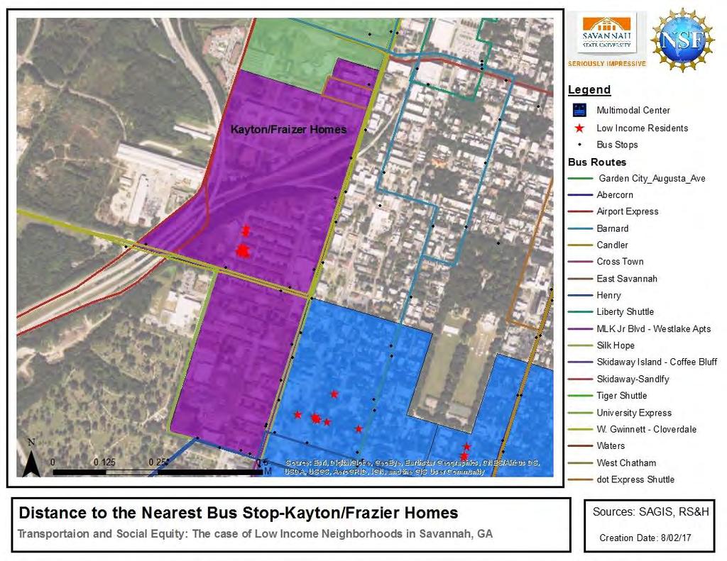
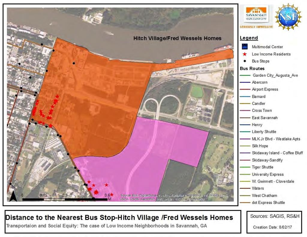
7 Data Description There are six (6) low income neighborhoods across which the data was retrieved. A total of 424 residence surveyed. Kayton/Frazier Homes Hitch Village/Fred Wessels MLK Neighborhoods Yamacraw Village West Savannah Neighborhoods Blackshear Homes.
8 TABLE SHOWING THE DIFFERENT CATEGORIES OF DATA COLLECTED Categories Survey Year Total Number of Respondents First year Respondents Year 1 (2012) 311 First Time Respondents From Second Year Year 2 (2013) 37 First Time respondents Who answered second Year Survey Year (2013) 21 Second time Respondents Year (2013) 55


9 Data Analysis Table Showing Descriptive Statistics Of Body Mass Index For First Year Respondents (2012) Histogram Showing Normal Curve Of BMI For First Year Respondents (2012)


10 Data Analysis Table Showing Descriptive Statistics Of Body Mass Index For First Time Respondents In (2013) Histogram Showing Normal Curve Of BMI For First Time Respondents (2013)
11 Using GIS To Tell Our Story 1. What is the average distance travelled by residents in low-income neighborhoods to the closest bus stop? 2. What is the average distance travelled by residents in low-income neighborhoods to the furthest bus stop. 3. How many bus routes are made available throughout low-income neighborhoods in Savannah, GA and What is the total number of Bus stops In and around low-income neighborhoods? 4. Do most low income residents travel more that a half mile radius to the closest bus stop from their home?

12 Geographic location of the low-income neighborhoods surveyed
 lowincome neighborhoods")
13 Concentration of poverty within the six(6) lowincome neighborhoods surveyed.

14 Bus stops and bus routes available to lowincome residents.

15 Quarter of a mile buffer showing coverage of public transit in Savannah, Chatham County

16 The average distance travelled from low income residents home to the closet bus stop.

17
18
19
20
21
22 Visualization by GIS The Chatham Area Transit has 1526 bus stops along the bus route coverage shown in map of which are located in and the around the low-income neighborhoods of Savannah mentioned earlier. That is 3.85% availability to resident living in these Low-Income neighborhoods.
23 Visualization by GIS There are over 23 routes operating daily throughout Chatham County, however, only 7 routes are easily accessible from these low-income neighborhoods. To answer the final research question most of the low income residents do travel more than a half mile radius in order to access the closest bus stop. Shortest commute to a bus stop 0.012miles Longest commute to a bus stop 1.15miles
24 Table Showing Near Spatial Calculation Results The Average Distance Travelled By Low Income Residents In Each Neighborhood Low-Income Neighborhoods in Savannah, GA Closest Distance travelled by a resident (linear units) Closet distances travelled by a resident (Miles) Furthest distances travelled by a resident (Linear units) Yamacraw Village Kayton/Frazier Homes MLK Hitch Village/Fred Wessels West Savannah Black Shear Homes Furthest Distance travelled by resident (Miles)
25 Indication of Findings The findings show that both bus routes and bus stops need to be expanded in and around the low-income neighborhoods of Savannah, GA. The need for self sufficiency If poor people acquire access to reliable and affordable public transportation that is in close proximity to their homes, social equity wouldn t be characterized as an incommensurable case and the need to maintain social equity of the haves may no longer need to come at the expense of the have-nots.
26 The Next Step In the process of conducting a spatial analysis of bus stop conditions within Savannah, GA. Variables (Canopy, Sidewalks, Bus stop furniture, signs)- 15 of 23 routes completed Frequency Weekend routes Aims Share data with CAT, SAGIS, and HUD
27 References Blumenberg, E., & Agrawal, A. W. (2015). Getting Around When You re Just Getting By: Transportation Survival Strategies of the Poor. Journal of Poverty, Hamrick, K. S., & Hopkins, D. (2012). The time cost of access to food Distance to the grocery store as measured in minutes. Electronic International Journal of Time Use Research, Kirstin, W., & Thill, J.-C. (2011). DO TRANSIT-DEPENDENT NEIGHBORHOODS RECEIVE INFERIOR BUS ACCESS? A NEIGHBORHOOD ANALYSIS IN FOUR U.S. CITIES. Journal of Urban Affairs, Manaugh, K., Badami, M. G., & El-Geneidy, A. M. (2015). Integrating social equity into urban transportation planning-a critical Evaluation of Equity objectives and measures in transportation plans in North America. Transport Policy, Mark, G., & Brian, T. (1999). Reconsidering Social Equity in Public Transit. Berkeley Planning Journal, 13(1), 6-27.
28 References Bollens, S. A. (1997). Concentrated Poverty and Metropolitan Equity Strategies. Board of Trustees of the Leland Sandford Junior University Stanford Law and Policy Review. Chaufana, C. D. (2012). It s a full time job being poor : understanding barriers to diabetes prevention in immigrant communities in the USA. Routledge, Criden, M. (2008). The Stranded Poor: Recognizing the Importance of Public Transportation for Low-Income Households. Washington. Fitchen, J. M. (1995). Spatial Redistribution of Poverty through Migration of Poor People to Depress Rural Communities. Rural Sociology, pp Garrett, M. T. (1999). Reconsidering Social Equity in Public Transit. Berkeley Planning Journal, 13(1), Litman, T. (2016). Evaluating Transportation Equity Manaugh, B. E.-G. (2014). Integrating Social Equity into Urban Transportation Planning.
29 Acknowledgements Funding for this research was provided by an NSF/TIPS-ITS grant to Dr. Deden Rukmana at Savannah State University, Savannah GA. Advance GIS Professor- Mr. Kevin Macleod- Spatial analysis Assistance
30 Questions? Where there is injustice for one, there is injustice for all. ~MLK
TUESDAYS AT APA PLANNING AND HEALTH. SAGAR SHAH, PhD AMERICAN PLANNING ASSOCIATION SEPTEMBER 2017 DISCUSSING THE ROLE OF FACTORS INFLUENCING HEALTH
 SAGAR SHAH, PhD sshah@planning.org AMERICAN PLANNING ASSOCIATION SEPTEMBER 2017 TUESDAYS AT APA PLANNING AND HEALTH DISCUSSING THE ROLE OF FACTORS INFLUENCING HEALTH Outline of the Presentation PLANNING
BROOKINGS May
 Appendix 1. Technical Methodology This study combines detailed data on transit systems, demographics, and employment to determine the accessibility of jobs via transit within and across the country s 100
A Comprehensive Method for Identifying Optimal Areas for Supermarket Development. TRF Policy Solutions April 28, 2011
 A Comprehensive Method for Identifying Optimal Areas for Supermarket Development TRF Policy Solutions April 28, 2011 Profile of TRF The Reinvestment Fund builds wealth and opportunity for lowwealth communities
Mapping and Health Equity Advocacy
 Mapping and Health Equity Advocacy Sarah Treuhaft PolicyLink November 7, 2008 About us PolicyLink National research and action institute that advances policies to achieve economic and social equity Center
Applying Health Outcome Data to Improve Health Equity
 Applying Health Outcome Data to Improve Health Equity Devon Williford, MPH, Health GIS Specialist Lorraine Dixon-Jones, Policy Analyst CDPHE Health Equity and Environmental Justice Collaborative Mile High
Integrating GIS into Food Access Analysis
 GIS Day at Kansas University Integrating GIS into Food Access Analysis Daoqin Tong School of Geography and Development Outline Introduction Research questions Method Results Discussion Introduction Food
Mapping Accessibility Over Time
 Journal of Maps, 2006, 76-87 Mapping Accessibility Over Time AHMED EL-GENEIDY and DAVID LEVINSON University of Minnesota, 500 Pillsbury Drive S.E., Minneapolis, MN 55455, USA; geneidy@umn.edu (Received
Together towards a Sustainable Urban Agenda
 Together towards a Sustainable Urban Agenda The City We (Youth) Want Preliminary findings from youth consultations Areas Issue Papers Policy Units 1.Social Cohesion and Equity - Livable Cities 2.Urban
East Bay BRT. Planning for Bus Rapid Transit
 East Bay BRT Planning for Bus Rapid Transit Regional Vision Draper Prison The Bottleneck is a State-Level issue, Salt Lake County 2050 Population: 1.5M Draper Prison hopefully with some State-Level funding!
GIS Analysis of Crenshaw/LAX Line
 PDD 631 Geographic Information Systems for Public Policy, Planning & Development GIS Analysis of Crenshaw/LAX Line Biying Zhao 6679361256 Professor Barry Waite and Bonnie Shrewsbury May 12 th, 2015 Introduction
Transit Time Shed Analyzing Accessibility to Employment and Services
 Transit Time Shed Analyzing Accessibility to Employment and Services presented by Ammar Naji, Liz Thompson and Abdulnaser Arafat Shimberg Center for Housing Studies at the University of Florida www.shimberg.ufl.edu
Frequently Asked Questions
 What is the Regional Transit Engagement Series? As one of the fastest growing regions in the country, there is recognition that long-term transit planning efforts should be accelerated if we are to remain
Developing Built Environment Indicators for Urban Oregon. Dan Rubado, MPH EPHT Epidemiologist Oregon Public Health Division
 Developing Built Environment Indicators for Urban Oregon Dan Rubado, MPH EPHT Epidemiologist Oregon Public Health Division What is the built environment? The built environment encompasses spaces and places
Impact of Metropolitan-level Built Environment on Travel Behavior
 Impact of Metropolitan-level Built Environment on Travel Behavior Arefeh Nasri 1 and Lei Zhang 2,* 1. Graduate Research Assistant; 2. Assistant Professor (*Corresponding Author) Department of Civil and
Identifying transit deserts in major Texas cities where the supplies missed the demands
 THE JOURNAL OF TRANSPORT AND LAND USE http://jtlu.org VOL. 10 NO. 1 [2017] pp. 529 540 Identifying transit deserts in major Texas cities where the supplies missed the demands Junfeng Jiao The University
NEW YORK AND CONNECTICUT SUSTAINABLE COMMUNITIES. Fair Housing & Equity Assessment & Regional Planning Enhancement
 NEW YORK AND CONNECTICUT SUSTAINABLE COMMUNITIES Fair Housing & Equity Assessment & Regional Planning Enhancement November 19, 2013 White Plains Public Library Federal grant to improve regional planning
The CRP stresses a number of factors that point to both our changing demographics and our future opportunities with recommendations for:
 Plan Overview The CRP represents the first broad planning initiative covering Lake, Porter and LaPorte counties. Unlike previous plans released by NIRPC, which focused primarily on transportation, the
A TRANSIT ACCESS ANALYSIS OF TANF RECIPIENTS IN THE CITY OF PORTLAND, OREGON
 A TRANSIT ACCESS ANALYSIS OF TANF RECIPIENTS IN THE CITY OF PORTLAND, OREGON By Thomas W. Sanchez Center for Urban Studies Portland State University ABSTRACT Little evidence exists regarding the relationship
Neighborhood social characteristics and chronic disease outcomes: does the geographic scale of neighborhood matter? Malia Jones
 Neighborhood social characteristics and chronic disease outcomes: does the geographic scale of neighborhood matter? Malia Jones Prepared for consideration for PAA 2013 Short Abstract Empirical research
Population Profiles
 U N D E R S T A N D I N G A N D E X P L O R I N G D E M O G R A P H I C C H A N G E MAPPING AMERICA S FUTURES, BRIEF 6 2000 2010 Population Profiles Atlanta, Las Vegas, Washington, DC, and Youngstown Allison
CRP 608 Winter 10 Class presentation February 04, Senior Research Associate Kirwan Institute for the Study of Race and Ethnicity
 CRP 608 Winter 10 Class presentation February 04, 2010 SAMIR GAMBHIR SAMIR GAMBHIR Senior Research Associate Kirwan Institute for the Study of Race and Ethnicity Background Kirwan Institute Our work Using
Economic and Social Urban Indicators: A Spatial Decision Support System for Chicago Area Transportation Planning
 Economic and Social Urban Indicators: A Spatial Decision Support System for Chicago Area Transportation Planning Piyushimita Thakuriah (Vonu), P.S. Sriraj, Paul Metaxatos, Inshu Minocha & Tanushri Swarup
STAR COMMUNITY RATING SYSTEM OBJECTIVE EE-4: EQUITABLE SERVICES & ACCESS COMMUNITY LEVEL OUTCOMES FOR KING COUNTY, WA
 STAR COMMUNITY RATING SYSTEM OBJECTIVE EE-4: EQUITABLE SERVICES & ACCESS COMMUNITY LEVEL OUTCOMES FOR KING COUNTY, WA OUTCOME I: EQUITABLE ACCESS AND PROXIMITY Background: This analysis has been developed
Regional Growth Strategy Regional Staff Committee
 Regional Growth Strategy Regional Staff Committee June 21, 2018 1 Overview Summary of June Growth Management Policy Board Regional Growth Strategy Objectives Regional Geographies Regional Growth Strategy
A Grocery Store for the Big Apple Research Question
 A Grocery Store for the Big Apple Research Question 0 To verify the validity of existing grocery stores, I searched all of the addresses on Google. Out of the original 1,547 results, only 62 were true,
Susan Clark NRS 509 Nov. 29, 2005
 Susan Clark NRS 509 Nov. 29, 2005 The original intent of this project was to look at the role of GIS in the inventory of bicycle and pedestrian facilities. The research, however, indicates a different
Regional Performance Measures
 G Performance Measures Regional Performance Measures Introduction This appendix highlights the performance of the MTP/SCS for 2035. The performance of the Revenue Constrained network also is compared to
Spatial and Socioeconomic Analysis of Commuting Patterns in Southern California Using LODES, CTPP, and ACS PUMS
 Spatial and Socioeconomic Analysis of Commuting Patterns in Southern California Using LODES, CTPP, and ACS PUMS Census for Transportation Planning Subcommittee meeting TRB 95th Annual Meeting January 11,
HORIZON 2030: Land Use & Transportation November 2005
 PROJECTS Land Use An important component of the Horizon transportation planning process involved reviewing the area s comprehensive land use plans to ensure consistency between them and the longrange transportation
Smart Growth: Threat to the Quality of Life. Experience
 Smart Growth: Threat to the Quality of Life Presentation by Wendell Cox Wendell Cox Consultancy Visiting Professor Conservatoire National des Arts et Metiers Paris Frontier Centre for Public Policy Winnipeg
Applications of GIS in Health Research. West Nile virus
 Applications of GIS in Health Research West Nile virus Outline Part 1. Applications of GIS in Health research or spatial epidemiology Disease Mapping Cluster Detection Spatial Exposure Assessment Assessment
Measuring Poverty. Introduction
 Measuring Poverty Introduction To measure something, we need to provide answers to the following basic questions: 1. What are we going to measure? Poverty? So, what is poverty? 2. Who wants to measure
APPENDIX PHASE 1 GREEN INFRASTRUCTURE FRAMEWORK
 APPENDIX PHASE 1 GREEN INFRASTRUCTURE FRAMEWORK KANSAS MISSOURI CONTENTS A DATA WISHLIST 4 B PRECEDENTS 7 C WORKSHOP MATERIALS 13 D ANALYSIS PROCESS 124 E ATLAS & PLAYBOOK DETAILS 156 F POLICY ANALYSIS
Figure 8.2a Variation of suburban character, transit access and pedestrian accessibility by TAZ label in the study area
 Figure 8.2a Variation of suburban character, transit access and pedestrian accessibility by TAZ label in the study area Figure 8.2b Variation of suburban character, commercial residential balance and mix
An online data and consulting resource of THE UNIVERSITY OF TOLEDO THE JACK FORD URBAN AFFAIRS CENTER
 An online data and consulting resource of THE JACK FORD URBAN AFFAIRS CENTER THE CENTER FOR GEOGRAPHIC INFORMATION SCIENCE AND APPLIED GEOGRAPHICS DEPARTMENT OF GEOGRAPHY AND PLANNING THE UNIVERSITY OF
Section III: Poverty Mapping Results
 Section III: Poverty Mapping Results Figure 5: Gewog level rural poverty map 58. The most prominent result from the poverty mapping exercise of Bhutan is the production of a disaggregated poverty headcount
Stability, Ability and Equity
 Stability, Ability and Equity Mobility and Protection in the Urban Context Arup Banerji Senior Director and Head of Global Practice, Social Protection and Labor The World Bank Group 1 ECONOMIC MOBILITY
Impact of transport projects on accessibility and mobility of the urban poor Case of the Delhi Metro
 Impact of transport projects on accessibility and mobility of the urban poor Case of the Delhi Metro Presentation By: Anvita Arora TRIPP, IITD Transport Innovations (TI), Delhi Bicycle Partnership Program,
What is new at ArcGIS 10.2? David Parry
 What is new at ArcGIS 10.2? David Parry What s new http://www.esri.com/software/ arcgis/arcgis10/features http://resources.arcgis.com/en/help/main/10.2/# /What_s_new_in_ArcGIS_10_2/016w0000005s 000000/
Travel behavior of low-income residents: Studying two contrasting locations in the city of Chennai, India
 Travel behavior of low-income residents: Studying two contrasting locations in the city of Chennai, India Sumeeta Srinivasan Peter Rogers TRB Annual Meet, Washington D.C. January 2003 Environmental Systems,
Assessing spatial distribution and variability of destinations in inner-city Sydney from travel diary and smartphone location data
 Assessing spatial distribution and variability of destinations in inner-city Sydney from travel diary and smartphone location data Richard B. Ellison 1, Adrian B. Ellison 1 and Stephen P. Greaves 1 1 Institute
Environmental Analysis, Chapter 4 Consequences, and Mitigation
 Environmental Analysis, Chapter 4 4.17 Environmental Justice This section summarizes the potential impacts described in Chapter 3, Transportation Impacts and Mitigation, and other sections of Chapter 4,
A/Prof. Mark Zuidgeest ACCESSIBILITY EFFECTS OF RELOCATION AND HOUSING PROJECT FOR THE URBAN POOR IN AHMEDABAD, INDIA
 A/Prof. Mark Zuidgeest ACCESSIBILITY EFFECTS OF RELOCATION AND HOUSING PROJECT FOR THE URBAN POOR IN AHMEDABAD, INDIA South African Cities Network/University of Pretoria, 09 April 2018 MOBILITY Ability
NEW YORK AND CONNECTICUT SUSTAINABLE COMMUNITIES. Fair Housing & Equity Assessment & Regional Planning Enhancement
 NEW YORK AND CONNECTICUT SUSTAINABLE COMMUNITIES Fair Housing & Equity Assessment & Regional Planning Enhancement November 18, 2013 Fordham University Bronx, NY Federal grant to improve regional planning
Purpose Study conducted to determine the needs of the health care workforce related to GIS use, incorporation and training.
 GIS and Health Care: Educational Needs Assessment Cindy Gotz, MPH, CHES Janice Frates, Ph.D. Suzanne Wechsler, Ph.D. Departments of Health Care Administration & Geography California State University Long
NEW YORK DEPARTMENT OF SANITATION. Spatial Analysis of Complaints
 NEW YORK DEPARTMENT OF SANITATION Spatial Analysis of Complaints Spatial Information Design Lab Columbia University Graduate School of Architecture, Planning and Preservation November 2007 Title New York
Policy Note 6. Measuring Unemployment by Location and Transport: StepSA s Access Envelope Technologies
 6 Measuring Unemployment by Location and Transport: StepSA s Access Envelope Technologies Introduction Increasing emphasis is coming onto spatial planning as government in South Africa moves to address
North Carolina Essential Standards Kindergarten Social Studies
 North Carolina s Kindergarten Social Studies Kindergarten through second grade students are introduced to an integrative approach of Social Studies by exploring aspects of self, others, families and communities
SPATIAL INEQUALITIES IN PUBLIC TRANSPORT AVAILABILITY: INVESTIGATION WITH SMALL-AREA METRICS
 SPATIAL INEQUALITIES IN PUBLIC TRANSPORT AVAILABILITY: INVESTIGATION WITH SMALL-AREA METRICS Research conducted by Yeran Sun and Piyushimita (Vonu) Thakuriah Presented by Obinna C.D. Anejionu INTRODUCTION
Neighborhood Locations and Amenities
 University of Maryland School of Architecture, Planning and Preservation Fall, 2014 Neighborhood Locations and Amenities Authors: Cole Greene Jacob Johnson Maha Tariq Under the Supervision of: Dr. Chao
Jobs-Housing Fit: Linking Housing Affordability and Local Wages
 Jobs-Housing Fit: Linking Housing Affordability and Local Wages Alex Karner, PhD Assistant Professor School of City and Regional Planning Georgia Institute of Technology Chris Benner, PhD Dorothy E. Everett
A Framework for the Study of Urban Health. Abdullah Baqui, DrPH, MPH, MBBS Johns Hopkins University
 This work is licensed under a Creative Commons Attribution-NonCommercial-ShareAlike License. Your use of this material constitutes acceptance of that license and the conditions of use of materials on this
Medical GIS: New Uses of Mapping Technology in Public Health. Peter Hayward, PhD Department of Geography SUNY College at Oneonta
 Medical GIS: New Uses of Mapping Technology in Public Health Peter Hayward, PhD Department of Geography SUNY College at Oneonta Invited research seminar presentation at Bassett Healthcare. Cooperstown,
Frans Thissen Department of Geography, Planning and International Development Studies Rural Poverty in Flanders
 Frans Thissen Department of Geography, Planning and International Development Studies Rural Poverty in Flanders a diversity of poverty in a diversity of places Rural poverty research in Flanders Henk Meert
Assessing Social Vulnerability to Biophysical Hazards. Dr. Jasmine Waddell
 Assessing Social Vulnerability to Biophysical Hazards Dr. Jasmine Waddell About the Project Built on a need to understand: The pre-disposition of the populations in the SE to adverse impacts from disaster
International Journal of Computing and Business Research (IJCBR) ISSN (Online) : APPLICATION OF GIS IN HEALTHCARE MANAGEMENT
 ISSN (Online) : APPLICATION OF GIS IN HEALTHCARE MANAGEMENT") International Journal of Computing and Business Research (IJCBR) ISSN (Online) : 2229-6166 Volume 3 Issue 2 May 2012 APPLICATION OF GIS IN HEALTHCARE MANAGEMENT Dr. Ram Shukla, Faculty (Operations Area),
International Journal of Computing and Business Research (IJCBR) ISSN (Online) : 2229-6166 Volume 3 Issue 2 May 2012 APPLICATION OF GIS IN HEALTHCARE MANAGEMENT Dr. Ram Shukla, Faculty (Operations Area),
Mapping the Route Identifying and Consulting with HS2 s Impacted Populations
 Tuesday 6 December 2016 Mapping the Route Identifying and Consulting with HS2 s Impacted Populations Carry Stephenson, Evelyn Robertson SYSTRA Michael Flynn HS2 Summary Study Context and Objectives Methodology
Thilo Becker
 Friedrich List Faculty of Transport and Traffic Science, Chair of Transport Ecology CAN THE CONCEPT OF ENVIRONMENTAL JUSTICE IN TRANSPORT BE TRANSFERRED TO CITIES OF THE SOUTH? A CASE STUDY OF NAIROBI
geographic patterns and processes are captured and represented using computer technologies
 Proposed Certificate in Geographic Information Science Department of Geographical and Sustainability Sciences Submitted: November 9, 2016 Geographic information systems (GIS) capture the complex spatial
Creating a Pavement Management System Using GIS
 Christopher Castruita PPD 631 Prof. Barry Waite & Prof. Bonnie Shrewsbury Creating a Pavement Management System Using GIS Problem Definition As is the case with many cities, the city of La Cañada Flintridge
Regional Performance Measures
 G Performance Measures Regional Performance Measures Introduction This appendix highlights the performance of the MTP/SCS for 2035. The performance of the Revenue Constrained network also is compared to
Health and Medical Geography (GEOG 222)
") Spring 2019 Class meets: Tuesdays and Thursdays 12:30-1:45pm Carolina Hall Room 220 Instructor: Michael Emch Email: emch@unc.edu Course Objectives Health and Medical Geography (GEOG 222) This course is
Spring 2019 Class meets: Tuesdays and Thursdays 12:30-1:45pm Carolina Hall Room 220 Instructor: Michael Emch Email: emch@unc.edu Course Objectives Health and Medical Geography (GEOG 222) This course is
Factors Affecting Human Settlement
 Factors Affecting Human Settlement Physical Factors One of the most basic factors affecting settlement patterns is the physical geography of the land. Climate is key, because if a place is too dry, too
SPACE-TIME ACCESSIBILITY MEASURES FOR EVALUATING MOBILITY-RELATED SOCIAL EXCLUSION OF THE ELDERLY
 SPACE-TIME ACCESSIBILITY MEASURES FOR EVALUATING MOBILITY-RELATED SOCIAL EXCLUSION OF THE ELDERLY Izumiyama, Hiroshi Institute of Environmental Studies, The University of Tokyo, Tokyo, Japan Email: izumiyama@ut.t.u-tokyo.ac.jp
A Comparison of the Accessibility of Three Neighborhoods Institutions and Amenities in Frederick, MD
 A Comparison of the Accessibility of Three Neighborhoods Institutions and Amenities in Frederick, MD Elizabeth Hampton Christopher Johansson Yana Demireva Albert Engel Table of Contents EXECUTIVE SUMMARY...
The 3V Approach. Transforming the Urban Space through Transit Oriented Development. Gerald Ollivier Transport Cluster Leader World Bank Hub Singapore
 Transforming the Urban Space through Transit Oriented Development The 3V Approach Gerald Ollivier Transport Cluster Leader World Bank Hub Singapore MDTF on Sustainable Urbanization The China-World Bank
We Can Get There From Here: New Perspectives on Transportation Equity
 We Can Get There From Here: New Perspectives on Transportation Equity SEPTEMBER 2016 A White Paper from the National Center for Sustainable Transportation Alex Karner, Georgia Institute of Technology Dana
Policy Paper Alabama Primary Care Service Areas
 Aim and Purpose Policy Paper Alabama Primary Care Service Areas Produced by the Office for Family Health Education & Research, UAB School of Medicine To create primary care rational service areas (PCSA)
Geospatial Analysis of Job-Housing Mismatch Using ArcGIS and Python
 Geospatial Analysis of Job-Housing Mismatch Using ArcGIS and Python 2016 ESRI User Conference June 29, 2016 San Diego, CA Jung Seo, Frank Wen, Simon Choi and Tom Vo, Research & Analysis Southern California
Measuring Performance:
 Accessibility Metrics in Metropolitan Regions around the World Geneviève Boisjoly and Ahmed El-Geneidy August 2017 Table of Contents Executive Summary...3 1 Introduction...4 2 Theoretical Background...4
GIS as a tool for rural livelihoods enhancement planning
 GIS as a tool for rural livelihoods enhancement planning (Case study of Alosylat region -Shareg Alnil-Sudan) Almojtaba M. H. Hassabo Federal Ministry of Agriculture Sudan A research submitted to the Development
A Review of Concept of Peri-urban Area & Its Identification
 A Review of Concept of Peri-urban Area & Its Identification Ar. Manita Saxena Research Scholar Department of Architecture and Planning M.A.N.I.T, Bhopal Dr. Supriya Vyas Assistant Professor, Department
Urban Form and Travel Behavior:
 Urban Form and Travel Behavior: Experience from a Nordic Context! Presentation at the World Symposium on Transport and Land Use Research (WSTLUR), July 28, 2011 in Whistler, Canada! Petter Næss! Professor
Social Studies Grade 2 - Building a Society
 Social Studies Grade 2 - Building a Society Description The second grade curriculum provides students with a broad view of the political units around them, specifically their town, state, and country.
Understanding Land Use and Walk Behavior in Utah
 Understanding Land Use and Walk Behavior in Utah 15 th TRB National Transportation Planning Applications Conference Callie New GIS Analyst + Planner STUDY AREA STUDY AREA 11 statistical areas (2010 census)
Travel to School: Social and Spatial Inequalities in Local Housing and Education Markets
 Travel to School: Social and Spatial Inequalities in Local Housing and Education Markets Dr Sue Easton Department of Town & Regional Planning University of Sheffield Travel to School Policy Contexts/ Debates
Accessibility as an Instrument in Planning Practice. Derek Halden DHC 2 Dean Path, Edinburgh EH4 3BA
 Accessibility as an Instrument in Planning Practice Derek Halden DHC 2 Dean Path, Edinburgh EH4 3BA derek.halden@dhc1.co.uk www.dhc1.co.uk Theory to practice a starting point Shared goals for access to
Forecasts for the Reston/Dulles Rail Corridor and Route 28 Corridor 2010 to 2050
 George Mason University Center for Regional Analysis Forecasts for the Reston/Dulles Rail Corridor and Route 28 Corridor 21 to 25 Prepared for the Fairfax County Department of Planning and Zoning Lisa
1Department of Demography and Organization Studies, University of Texas at San Antonio, One UTSA Circle, San Antonio, TX
 Well, it depends on where you're born: A practical application of geographically weighted regression to the study of infant mortality in the U.S. P. Johnelle Sparks and Corey S. Sparks 1 Introduction Infant
Understanding China Census Data with GIS By Shuming Bao and Susan Haynie China Data Center, University of Michigan
 Understanding China Census Data with GIS By Shuming Bao and Susan Haynie China Data Center, University of Michigan The Census data for China provides comprehensive demographic and business information
Victorian Liveability Indicator Program: Definition, Measurement and Application
 Victorian Liveability Indicator Program: Definition, Measurement and Application Dr Hannah Badland Senior Research Fellow Place, Health, and Liveability Program Melbourne School of Population and Global
Regional Snapshot Series: Transportation and Transit. Commuting and Places of Work in the Fraser Valley Regional District
 Regional Snapshot Series: Transportation and Transit Commuting and Places of Work in the Fraser Valley Regional District TABLE OF CONTENTS Complete Communities Daily Trips Live/Work Ratio Commuting Local
ADDRESSING TITLE VI AND ENVIRONMENTAL JUSTICE IN LONG-RANGE TRANSPORTATION PLANS
 ADDRESSING TITLE VI AND ENVIRONMENTAL JUSTICE IN LONG-RANGE TRANSPORTATION PLANS Activities from the National Capital Region Transportation Planning Board Sergio Ritacco Transportation Planner 2017 Association
Geographic Systems and Analysis
 Geographic Systems and Analysis New York University Robert F. Wagner Graduate School of Public Service Instructor Stephanie Rosoff Contact: stephanie.rosoff@nyu.edu Office hours: Mondays by appointment
MASSACHUSETTS FOOD ACCESS INDEX
 MASSACHUSETTS FOOD ACCESS INDEX A Pilot Method for Assessing Food Access in the Commonwealth Tufts University Department of Urban & Environmental Policy & Planning in partnership with Metropolitan Area
Measuring Perceived Accessibility to Urban Green Space: An Integration of GIS and Participatory Map
 Measuring Perceived Accessibility to Urban Green Space: An Integration of GIS and Participatory Map Fariba Sotoudehnia, Lex Comber 1,2 Department of Geography, University of Leicester, UK ABSTRACT Urban
Using New Technologies to Enhance your Research
 Using New Technologies to Enhance your Research Built Environment Audits with Google Street View Cheryl Kelly, PhD Jeff Wilson, PhD Saint Louis University School of Public Health Indiana University-Purdue
CHAPTER 4 HIGH LEVEL SPATIAL DEVELOPMENT FRAMEWORK (SDF) Page 95
 Page 95") CHAPTER 4 HIGH LEVEL SPATIAL DEVELOPMENT FRAMEWORK (SDF) Page 95 CHAPTER 4 HIGH LEVEL SPATIAL DEVELOPMENT FRAMEWORK 4.1 INTRODUCTION This chapter provides a high level overview of George Municipality s
CHAPTER 4 HIGH LEVEL SPATIAL DEVELOPMENT FRAMEWORK (SDF) Page 95 CHAPTER 4 HIGH LEVEL SPATIAL DEVELOPMENT FRAMEWORK 4.1 INTRODUCTION This chapter provides a high level overview of George Municipality s
County Public Health Department. A practical guide, lessons learned and current projects in a small local health department
 Integrating ti GIS into the El Dorado County Public Health Department y p A practical guide, lessons learned and current projects in a small local health department Presentation Overview How we got GIS
Leveraging Urban Mobility Strategies to Improve Accessibility and Productivity of Cities
 Leveraging Urban Mobility Strategies to Improve Accessibility and Productivity of Cities Aiga Stokenberga World Bank GPSC African Regional Workshop May 15, 2018 Roadmap 1. Africa s urbanization and its
Westside Extension Los Angeles, California
 Westside Extension Los Angeles, California Rail~Volution 2010 Portland, Oregon Monica Villalobos AECOM History of Westside Suburban Growth in the Westside (1920 1970 s) LA Centers Concept + Employment
Jeanette Eckert. September 22, 2015
 Jeanette Eckert September 22, 2015 Michigan State University Email: eckertj7@msu.edu Department of Geography Phone: 419-322-1454 673 Auditorium Road, Room 116 Website: www.msu.edu/~eckertj7 East Lansing,
Regional Growth Strategy Work Session Growth Management Policy Board
 Regional Growth Strategy Work Session Growth Management Policy Board September 6, 2018 1 Overview Recap June GMPB work session Objectives and outcomes Regional geographies Growth scenarios Breakout Discussion:
Telling Stories with Numbers Secondary data collection, presentation, and interpretation
 10/10/2013 Telling Stories with Numbers Secondary data collection, presentation, and interpretation Vincent Adams Coordinator, Rural Communities Explorer Oregon State University www.oregonexplorer.info/rural
OBESITY AND LOCATION IN MARION COUNTY, INDIANA MIDWEST STUDENT SUMMIT, APRIL Samantha Snyder, Purdue University
 OBESITY AND LOCATION IN MARION COUNTY, INDIANA MIDWEST STUDENT SUMMIT, APRIL 2008 Samantha Snyder, Purdue University Organization Introduction Literature and Motivation Data Geographic Distributions ib
The Role of Transitways in Our Region s Economic Competitiveness. The 23rd CTS Annual Research Conference St. Paul, MN May 23, 2012
 The Role of Transitways in Our Region s Economic Competitiveness The 23rd CTS Annual Research Conference St. Paul, MN May 23, 2012 1 2 Twin Cities Competitive Clusters 3 Competitive Clusters interconnected
Spatiotemporal Analysis of Commuting Patterns in Southern California Using ACS PUMS, CTPP and LODES
 Spatiotemporal Analysis of Commuting Patterns in Southern California Using ACS PUMS, CTPP and LODES 2017 ACS Data Users Conference May 11-12, 2017 Alexandria, VA Jung Seo, Tom Vo, Frank Wen and Simon Choi
Low-Income African American Women's Perceptions of Primary Care Physician Weight Loss Counseling: A Positive Deviance Study
 Thomas Jefferson University Jefferson Digital Commons Master of Public Health Thesis and Capstone Presentations Jefferson College of Population Health 6-25-2015 Low-Income African American Women's Perceptions
ACCESS AND MOBILITY IN GAUTENG S PRIORITY TOWNSHIPS WHAT CAN THE 2011 QUALITY OF LIFE SURVEY TELL US? ABSTRACT
 ACCESS AND MOBILITY IN GAUTENG S PRIORITY TOWNSHIPS WHAT CAN THE 2011 QUALITY OF LIFE SURVEY TELL US? C VENTER Department of Civil Engineering, University of Pretoria, Pretoria, 0002, Tel (012) 420-2184,