ENVIRONMENTAL DIVISION Arkansas State Highway and Transportation Department. Streamlining Environmental Assessment through GIS
|
|
|
- Clifton Turner
- 6 years ago
- Views:
Transcription


1 ENVIRONMENTAL DIVISION Arkansas State Highway and Transportation Department Streamlining Environmental Assessment through GIS 2 September, 2003
2 ARKANSAS STATE HIGHWAY AND TRANSPORTATION DEPARTMENT ENVIRONMENTAL DIVISION GIS UNIT HISTORY AHTD Environmental Division GIS Unit was initiated November 2000 Fully Operational January 2001 Section Status as of July 2003 GIS Section Team: GIS Section Head Robert Fuhler * Senior GIS Coordinator (July, 2001) * GPS Coordinator (January, 2002) Robert Reed Environmental GIS/GPS Analyst (June, 2003) Max Farrell GIS Analyst (June, 2003) Bart Dudley GIS Graphics Technician (Forever) Elaine Sullivan Intern Scott Alsbrook March, 2004
3

4
5 INFORMATION GATHERING AND EXCHANGE Arkansas Hwy & Trans Dept Federal Agencies Planning & Research Division FHWA Surveys Division EPA Roadway Design Division FEMA Computer Services US Fish & Wildlife Service Bridge Division US Forest Service Materials Division NRCS Universities and Schools University of Arkansas Fayetteville Center for Advanced Spatial Technologies (CAST) Soils Physics Lab GeoStor University of Arkansas Monticello Spatial Analysis Lab (SAL) University of Central Arkansas Conway Intern Program Geography Department Intern Program Biology Department (pending) EAST Program Consultants Corp of Engineers State/Local Agencies Arkansas Dept of Information Svcs Arkansas Dept of Environmental Quality Ark ansas Dept of Health Office of Emergency Svcs Arkansas Game and Fish Commission State Historic Preservation Office Arkansas Archaeological Survey Municipal Government County Government State Land Commissioner s Office 211 September, March,
6 IN-HOUSE AND ACQUIRED DATA In-House Data Acquired Hazardous Waste consolidation General Land Office Digital Data Historic Bridges Select Prime Farmlands Noise Analysis Land Cover Land Use Aerial Imagery Survey Arkansas Base Data (Mapping Section, P&R) FEMA GNIS-USGS National Hydrography Units for Arkansas EPA Data Environmentally Sensitive Rivers Scenic and Historic Rivers National Forests (USFS) Public Water Wellheads (DOH) Landfills (ADEQ) National Wetlands Inventory SSURGO Certified Soils by County USACE Arkansas Districts AHPP Historic Districts 211 September, March,
7 Universities and Schools Data and Personnel Resources University of Arkansas Fayetteville Center for Advanced Spatial Technologies (CAST) Soils Physics Lab (works with NRCS) GeoStor Development University of Arkansas Monticello Spatial Analysis Lab (SAL) University of Central Arkansas Conway Intern Program Geography Department Intern Program Biology Department (pending) Environmental & Spatial Technology (EAST) Consortium Established since Schools in 7 states (AL, AR,CA, HA, IL, LA, MS) Over 20,000 Students currently enrolled 211 September, March,
8 STATE AND MUNICIPAL AGENCIES Arkansas Geographic Information Office (AGIO) GeoStor Access through this Office Arkansas Department of Environmental Quality (ADEQ) Landfills (Legal/Illegal; open/closed) Industrial Facilities Storage Tanks (Under and Above Ground) Hazardous Waste Notifier Arkansas Department of Health (ADOH) Water Sources Wellhead Protection Areas Arkansas Game and Fish Commission State Historic Preservation Office (SHPO) Historic Structures and Sites Arkansas Archeological Survey (UA, Fayetteville) Archeological Reports Sensitive Archeological Locations Municipal and County Government Land Plats, City Limits State Land Commissioner s Office General Land Office Plats (scanned tifs) Wildlife Management Area Boundaries Endangered & Threatened Species 211 September, March,
9 DEVELOP AND/OR HOST USERS GROUPS AHTD GIS Users Group In force since 1998 Primarily discusses methodology and database design Group training involves CADD techniques as well Location of various data in other Divisions is also discussed by their own representatives. Arkansas GIS Users Forum State-wide GIS Users Group Makes coordination much easier Host Various Federal/State/Local Groups Data dispersal and education on other databases and designs Cooperative efforts much easier when meetings are hosted face-to-face 211 September, March,
10 ONGOING PROJECT EXAMPLES MAX FARRELL ENVIRONMENTAL GIS ANALYST 11 March, 2004

11 GIS AND LOW-STRENGTH SOILS

12 LOW STRENGTH SOILS/GENERAL HWY MAP AND QUADRANGLE


13 SPECIAL STUDIES SECTION Significant protection of wetlands as integral and essential parts of the nation s water. Section 404 of the Clean Water Act GIS Technology is helpful in this process in many ways: - Wetland Mitigation - Wetland Delineation - Endangered Species Protection - Historic Water Evaluation - Soils
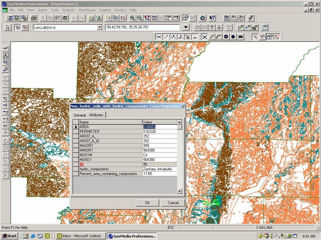
14 ASSESSMENT SECTION Prime Farmland -(Farm Protection Policy Act) Federal Programs which contribute to the unnecessary and irreversible conversion of farmland to nonagricultural uses will be minimized -Soils: Query Certain Type of Soils and Calculate Acreage Water Quality -Redline Data -Public Water Supply -Wellhead Protection Areas ALESTINE FORREST CITY MADISON WIDE»Use to GIS Buffer From Each Public Water Supply Wellhead. These Buffers Then Become Wellhead Protection Areas. Layer Used to Mitigate, Minimize and Avoid These Areas During Projects Wellhead Protection Special Provision September, March,
15
16
17
18
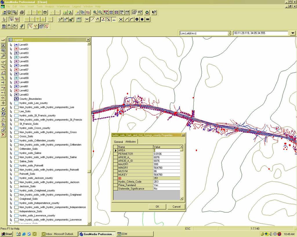
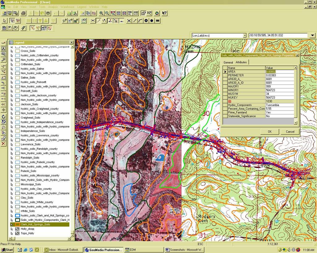
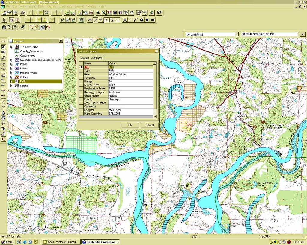
19 CULTURAL RESOURCE SECTION Archeology - GLOS - Recording sites and see if impacted by proposed job - Modeling potential sites - Locate new Sites and incorporate into GIS Historic Structures Historic Bridge Management System 211 September, March,
20 GLO PROJECT A Brief History Need For GLO Database Applications GIS Methodology Caveats Work in Progress 211 September, March,


21 A BRIEF HISTORY Land Ordinance of 1785 Rectangular Survey System Survey Team Usually Consisted of 5 Men Gunter s Chain Plat sketched and labeled in a field book
22 NEED FOR GLO DIGITAL DATABASE Digitally Document the Cultural and Natural Features Noted on the GLO Plats A Quick and Efficient Method for Staff Archeologists to Access GLO Plat Information A New Way to Model and Predict Potential Historically Valuable Sites An Easy Way to Query Cultural, Commercial, Historic and Historic Water Data Facilitate New Studies into Such Areas as Historic Transportation Networks, Historic Wetlands, Historic Watersheds and Native American Lands 211 September, March,
")

23 METHODOLOGY 1) Acquire GLO Plats from State Land Office CD ROM 2) Search for Plat in Alchemy Search Engine 211 September, March,

24 METHODOLOGY CONTINUED 3) Name and Save Plat as TIFF 4) Import Plat into IRAS-C for Geo- Referencing 211 September, March,

25 METHODOLOGY CONTINUED 5) Geo-Reference to AHTD Mapping Section s Township Coverage File 211 September, March,

26 METHODOLOGY CONTINUED 6) Bring Geo-Referenced Image into GeoMedia Professional 4.0 to be digitized 211 September, March,

27 METHODOLOGY CONTINUED 7) After the Feature is Digitized it is then Assigned Attributes 211 September, March,

28 METHODOLOGY CONTINUED 8) Attribute Table 211 September, March,
29 GLO PLAT CAVEATS Precision Not as Accurate as Present Day Surveys. Gunter s Chain Observations and Descriptions Influenced by Cultural and Educational Backgrounds 211 September, March,
30 DIGITAL GLO DATA CAVEATS Data Collection Occurred Over a Long Period of Time Inconsistencies Among Surveyors Data Collection Obstacles Potential Errors Because of the Digitizing Process Edge Matching 211 September, March,
31 EDGE MATCHING 211 September, March,

32 EDGE MATCHING 15 N 32 W M 32 W 1834
33 OVERALL ACCURACY
34
35 Mangers Woodrow farm spring State House Rapleys store ferry Memphis road river crossing house Mrs. Trapmalls street street Col.? road Cap.? Killian's; Watkins: JR Reans street Watkins house field Arsenal grounds College grounds cemetery street Dr.? Mrs. Fultons road
 211 September, March,")
36 IMAGERY USGS Quadrangle Digital Ortho Quarter Quad (DOQQ) 211 September, March,
37
38 Archeologists APPLICATIONS Has Someone Been There Historically? Movement of People Historic Waters Transportation Corridors Native American Lands Historians Information is Historic Document and Study Historic Transportation Networks Historic Wetlands Historic Watersheds Native American Lands 11 March, 2004
39 Grassy Lake 1848 GLO Plat Grassy Lake 1983 USGS Topographic Map Crooked Lake 1848 GLO Plat Campbell s Oldfield Lake 1848 GLO Plat

40 Grassy Lake 1848 GLO Plat Crooked Lake 1848 GLO Plat Campbell s Oldfield Lake 1848 GLO Plat
41 WORK IN PROGRESS Over 2500 GLO Plats to Process Approximately?? Percent Have Been Geo- Referenced 211 September, March,

42 QUESTIONS Please feel free to contact me if you have any questions or comments at THANK YOU!! 211 September, March,
43 ENVIRONMENTAL DIVISION Arkansas State Highway and Transportation Department Streamlining Environmental Assessment through GIS 2 September, 2003
Louisiana Transportation Engineering Conference. Monday, February 12, 2007
 Louisiana Transportation Engineering Conference Monday, February 12, 2007 Agenda Project Background Goal of EIS Why Use GIS? What is GIS? How used on this Project Other site selection tools I-69 Corridor
John Laznik 273 Delaplane Ave Newark, DE (302)
") Office Address: John Laznik 273 Delaplane Ave Newark, DE 19711 (302) 831-0479 Center for Applied Demography and Survey Research College of Human Services, Education and Public Policy University of Delaware
Office Address: John Laznik 273 Delaplane Ave Newark, DE 19711 (302) 831-0479 Center for Applied Demography and Survey Research College of Human Services, Education and Public Policy University of Delaware
Digital Wetlands. Bringing the Field into the Office Through GIS
 Digital Wetlands Bringing the Field into the Office Through GIS Maryland Department of the Environment Wetlands and Waterways Program MDE's Wetlands and Waterways Program seeks to conserve valuable aquatic
Development of Webbased. Tool for Tennessee
 Development of Webbased Farm Mapping Tool for Tennessee Southern Region Water Quality Conference, Oct. 24 2005 Forbes Walker and Alan Jolly Biosystems Engineering and SOIL SCIENCE Nutrient Management Planning
Appendix C. Questionnaire Summary of Responses Geographic Information Systems
 Appendix C Questionnaire Summary of Responses Geographic Information Systems 1. Is your agency using or planning use of GIS for: a. general mapping (e.g. highway routes, political boundaries, etc.) b.
INDIANAMAP VIEWING APPLICATION
 INDIANAMAP VIEWING APPLICATION (VERSION 1.0 ) Based on the 2005 Developed for the Indiana Department of Homeland Security by: IndianaMap Viewing Application Introduction The IndianaMap Viewing Application
An Internet-Based Integrated Resource Management System (IRMS)
") An Internet-Based Integrated Resource Management System (IRMS) Third Quarter Report, Year II 4/1/2000 6/30/2000 Prepared for Missouri Department of Natural Resources Missouri Department of Conservation
An Internet-Based Integrated Resource Management System (IRMS) Third Quarter Report, Year II 4/1/2000 6/30/2000 Prepared for Missouri Department of Natural Resources Missouri Department of Conservation
COMMUNITY SERVICE AREA
 INSTITUTE FOR TRIBAL ENVIRONMENTAL PROFESSIONALS Tribal Waste and Response Assistance Program (TWRAP) Developing and Implementing a Tribal Integrated Solid Waste Management Plan April 12-14, 2016 Palm
Wetland Mapping. Wetland Mapping in the United States. State Wetland Losses 53% in Lower US. Matthew J. Gray University of Tennessee
 Wetland Mapping Caribbean Matthew J. Gray University of Tennessee Wetland Mapping in the United States Shaw and Fredine (1956) National Wetlands Inventory U.S. Fish and Wildlife Service is the principle
GIS Geographical Information Systems. GIS Management
 GIS Geographical Information Systems GIS Management Difficulties on establishing a GIS Funding GIS Determining Project Standards Data Gathering Map Development Recruiting GIS Professionals Educating Staff
StreBanD DSS: A Riparian Buffer Decision Support System for Planners
 StreBanD DSS: A Riparian Buffer Decision Support System for Planners Dharmendra Saraswat Assoc. Prof,/Ext. Engineer- Geospatial 501-681-5987 (mobile) dsaraswat@uaex.edu Acknowledgment Project Team: Dr.
MVP WMS, George Schorr
 APPROVED JURISDICTIONAL DETERMINATION FORM U.S. Army Corps of Engineers This form should be completed by following the instructions provided in Section IV of the JD Form Instructional Guidebook. SECTION
CENSUS MAPPING WITH GIS IN NAMIBIA. BY Mrs. Ottilie Mwazi Central Bureau of Statistics Tel: October 2007
 CENSUS MAPPING WITH GIS IN NAMIBIA BY Mrs. Ottilie Mwazi Central Bureau of Statistics E-mail: omwazi@npc.gov.na Tel: + 264 61 283 4060 October 2007 Content of Presentation HISTORICAL BACKGROUND OF CENSUS
Statewide Topographic Mapping Program
 Statewide Topographic Mapping Program February 28, 2018 www.dotd.la.gov Outline Purpose of the Statewide Topographic Mapping Program History Breakdown of R.S. 48:36 - Topographic Mapping Statewide Topographic
PW Parkway ES Prince William County, Virginia WSSI #
 PW Parkway ES Prince William County, Virginia WSSI #15.3 Cultural Resources Site Assessment November 15 Prepared for: Prince William County Public Schools P.O. Box 39 Manassas, Virginia 1 Prepared by:
Summary Description Municipality of Anchorage. Anchorage Coastal Resource Atlas Project
 Summary Description Municipality of Anchorage Anchorage Coastal Resource Atlas Project By: Thede Tobish, MOA Planner; and Charlie Barnwell, MOA GIS Manager Introduction Local governments often struggle
Great California Delta Trail Blueprint for Contra Costa and Solano Counties GIS AND MAPPING MEMORANDUM JULY 2010
 Great California Delta Trail Blueprint for Contra Costa and Solano Counties GIS AND MAPPING MEMORANDUM JULY 2010 {DRAFT} July 2010 Introduction Geographic Information Systems (GIS) are computer-based
Information. Information Technology. Geographic. Services (GIS) 119 W Indiana Ave Deland, FL 32720
 119 W Indiana Ave Deland, FL 32720") Information Technology Geographic Information Services (GIS) 119 W Indiana Ave Deland, FL 32720 A GIS consists of 5 primary components: Hardware Software People Data Methods or Business Processes --- Hardware
Information Technology Geographic Information Services (GIS) 119 W Indiana Ave Deland, FL 32720 A GIS consists of 5 primary components: Hardware Software People Data Methods or Business Processes --- Hardware
An Internet-based Agricultural Land Use Trends Visualization System (AgLuT)
") An Internet-based Agricultural Land Use Trends Visualization System (AgLuT) Prepared for Missouri Department of Natural Resources Missouri Department of Conservation 07-01-2000-12-31-2001 Submitted by
An Internet-based Agricultural Land Use Trends Visualization System (AgLuT) Prepared for Missouri Department of Natural Resources Missouri Department of Conservation 07-01-2000-12-31-2001 Submitted by
ADMINISTRATION DEPARTMENT Land Management Information Center. An Inventory of Its Records
 MINNESOTA HISTORICAL SOCIETY Minnesota State Archives ADMINISTRATION DEPARTMENT Land Management Information Center An Inventory of Its Records OVERVIEW OF THE RECORDS Agency: Series Title: Land Management
GEOGRAPHIC INFORMATION SYSTEMS
 GEOGRAPHIC INFORMATION SYSTEMS 4-H Round-Up Community Transitions Workshop Daniel Hanselka June 14, 2011 Goals of the Workshop Answer the question: What is GIS? Uses of GIS. Some of the Common Terminology
Storm Surge Analysis Update Meeting Cross City, Florida June 17, 2014
 Big Bend Coastal Storm Surge Study Storm Surge Analysis Update Meeting Cross City, Florida June 17, 2014 Introductions Risk MAP Project Team FEMA Region IV Florida Division of Emergency Management (FDEM)
McHenry County Property Search Sources of Information
 Disclaimer: The information in this system may contain inaccuracies or typographical errors. The information in this system is a digital representation of information derived from original documents; as
Technical Drafting, Geographic Information Systems and Computer- Based Cartography
 Technical Drafting, Geographic Information Systems and Computer- Based Cartography Project-Specific and Regional Resource Mapping Services Geographic Information Systems - Spatial Analysis Terrestrial
APPROVED JURISDICTIONAL DETERMINATION FORM U.S. Army Corps of Engineers
 APPROVED JURISDICTIONAL DETERMINATION FORM U.S. Army Corps of Engineers This form should be completed by following the instructions provided in Section IV of the JD Form Instructional Guidebook. SECTION
A Summary of State DOT GIS Activities. Presented at the 2000 AASHTO GIS-T Symposium Minneapolis, MN
 A Summary of State DOT GIS Activities Presented at the 2000 AASHTO GIS-T Symposium Minneapolis, MN Information Sources E-mail survey of state DOT GIS managers 49 State DOTs responded in 2000 Results compared
McHenry County Property Search Sources of Information
 Disclaimer: The information in this system may contain inaccuracies or typographical errors. The information in this system is a digital representation of information derived from original documents; as
What s Happening in My Watershed?
 What s Happening in My Watershed? How Implementing a GIS system to Utilize Spatial Data and Digital Collection Techniques can help Solve Watershed Issues. Mindi J. Parsell City of Tulsa Stormwater Quality
Ecological Land Cover Classification For a Natural Resources Inventory in the Kansas City Region, USA
 Ecological Land Cover Classification For a Natural Resources Inventory in the Kansas City Region, USA by Applied Ecological Services, Inc. In cooperation with the Mid-America Regional Council 600 Broadway,
Creating A-16 Compliant National Data Theme for Cultural Resources
 Creating A-16 Compliant National Data Theme for Cultural Resources Cultural Resource GIS Facility National Park Service John J. Knoerl Deidre McCarthy Paper 169 Abstract OMB Circular A-16 defines a set
SoilView: Development of a Custom GIS Application for Publishing Soil Surveys
 SoilView: Development of a Custom GIS Application for Publishing Soil Surveys Allan Johnson and Mike Wigginton Abstract Currently, digital soils information can be obtained from many sources. Numerous
1.1 What is Site Fingerprinting?
 Site Fingerprinting Utilizing GIS/GPS Technology 1.1 What is Site Fingerprinting? Site fingerprinting is a planning tool used to design communities where protection of natural resources is the primary
Techniques for Science Teachers: Using GIS in Science Classrooms.
 Techniques for Science Teachers: Using GIS in Science Classrooms. After ESRI, 2008 GIS A Geographic Information System A collection of computer hardware, software, and geographic data used together for
APPROVED JURISDICTIONAL DETERMINATION FORM U.S. Army Corps of Engineers
 APPROVED JURISDICTIONAL DETERMINATION FORM U.S. Army Corps of Engineers This form should be completed by following the instructions provided in Section IV of the JD Form Instructional Guidebook. SECTION
why is a national or regional context important?
 The need Accessibility to opportunities, Efficient movement of people and goods, Environmental Health Strength and competitiveness of the economy, Availability and cost of energy, Safety and Security,
Chesapeake Bay Remote Sensing Pilot Executive Briefing
 Chesapeake Bay Remote Sensing Pilot Executive Briefing Introduction In his Executive Order 13506 in May 2009, President Obama stated The Chesapeake Bay is a national treasure constituting the largest estuary
STEREO ANALYST FOR ERDAS IMAGINE Stereo Feature Collection for the GIS Professional
 STEREO ANALYST FOR ERDAS IMAGINE Stereo Feature Collection for the GIS Professional STEREO ANALYST FOR ERDAS IMAGINE Has Your GIS Gone Flat? Hexagon Geospatial takes three-dimensional geographic imaging
INDOT Office of Traffic Safety
 Intro to GIS Spatial Analysis INDOT Office of Traffic Safety Intro to GIS Spatial Analysis INDOT Office of Traffic Safety Kevin Knoke Section 130 Program Manager Highway Engineer II Registered Professional
APPROVED JURISDICTIONAL DETERMINATION FORM U.S. Army Corps of Engineers
 APPROVED JURISDICTIONAL DETERMINATION FORM U.S. Army Corps of Engineers This form should be completed by following the instructions provided in Section IV of the JD Form Instructional Guidebook. SECTION
Preparation of Database for Urban Development
 Preparation of Database for Urban Development By PunyaP OLI, 1. Chairman, ERMC (P) Ltd., Kathmandu, Nepal. Email: punyaoli@ermcnepal.com 2. Coordinator, Himalayan College of Geomatic Engineering and Land
Introduction to Geographic Information Systems (GIS): Environmental Science Focus
: Environmental Science Focus") Introduction to Geographic Information Systems (GIS): Environmental Science Focus September 9, 2013 We will begin at 9:10 AM. Login info: Username:!cnrguest Password: gocal_bears Instructor: Domain: CAMPUS
Introduction to Geographic Information Systems (GIS): Environmental Science Focus September 9, 2013 We will begin at 9:10 AM. Login info: Username:!cnrguest Password: gocal_bears Instructor: Domain: CAMPUS
NEW CONCEPTS - SOIL SURVEY OF THE FUTURE
 NEW CONCEPTS - SOIL SURVEY OF THE FUTURE The new process of doing soil surveys by Major Land Resource Areas (MLRA) highlights this section. Special emphasis is given to an overview of the National Soil
Town of Taos Request for Proposal Historic Preservation GIS Geodatabase Project April 2007
 Town of Taos Request for Proposal Historic Preservation GIS Geodatabase Project April 2007 1. Background The Town of Taos is requesting proposals from qualified firms or a team of firms who can develop
Geospatial Data, Services, and Products. National Surveying, mapping and geospatial conference
 Geospatial Data, Services, and Products Federal Programs -- USDA NRCS National Surveying, mapping and geospatial conference March 15, 2016 NRCS Applications using Geosaptial Products & Services Field
Use of Government Land Office Surveys in Tribal GIS Land Management. Dustin Holt GIS Technician Choctaw Nation of Oklahoma
 Use of Government Land Office Surveys in Tribal GIS Land Management Dustin Holt GIS Technician Choctaw Nation of Oklahoma Ardmore Quadrangle - 1949 Different versions of the same map were printed in 1901,
PPT Slide. Slide 1 of 32. Notes:
 Slide 1 of 32 This presentaion will describe the background of establishing an agricultural district in Westchester County and how GIS was used to map the district. file:///volumes/web/www/ce/conferences/gis%20present/testfarm/sld001.htm[4/6/11
March 2007 The Survey Department of Sri Lanka
 Contribution of Survey Department of Sri Lanka for Mitigation of Disasters in Sri Lanka K.A.U.N.Kasthuri Deputy Surveyor General (Information Technology) March 2007 The Survey Department of Sri Lanka 1
GIS Monroe Geographic Information System March 14, 2018
 GIS Monroe Geographic Information System March 14, 2018 Goals Maintain Enterprise/County-wide geo-database Increase spatial accuracy of data Build and acquire more data layers Increase use of GIS; as another
3D Elevation Program, Lidar in Missouri. West Central Regional Advanced LiDAR Workshop Ray Fox
 3D Elevation Program, Lidar in Missouri West Central Regional Advanced LiDAR Workshop Ray Fox National Enhanced Elevation Assessment (Dewberry, 2011) Sponsored by the National Digital Elevation Program
ENV208/ENV508 Applied GIS. Week 1: What is GIS?
 ENV208/ENV508 Applied GIS Week 1: What is GIS? 1 WHAT IS GIS? A GIS integrates hardware, software, and data for capturing, managing, analyzing, and displaying all forms of geographically referenced information.
Author(s): Charles K. Cover, P.E. Federal Energy Regulatory Commission
: Charles K. Cover, P.E. Federal Energy Regulatory Commission") Using GIS to Help Manage a National Energy Program Author(s): Charles K. Cover, P.E. Federal Energy Regulatory Commission The Federal Energy Regulatory Commission (FERC) has statutory oversight on key
Using GIS to Help Manage a National Energy Program Author(s): Charles K. Cover, P.E. Federal Energy Regulatory Commission The Federal Energy Regulatory Commission (FERC) has statutory oversight on key
Bridging between organizations for effective water resource management;
 Bridging between organizations for effective water resource management; a look at a stakeholder network in water governance issues of a rural subbasin aren Trebitz hd student, Water Resources, law, mgt.,
Too Close for Comfort
 Too Close for Comfort Overview South Carolina consists of urban, suburban, and rural communities. Students will utilize maps to label and describe the different land use classifications. Connection to
SRJC Applied Technology 54A Introduction to GIS
 SRJC Applied Technology 54A Introduction to GIS Overview Lecture of Geographic Information Systems Fall 2004 Santa Rosa Junior College Presented By: Tim Pudoff, GIS Coordinator, County of Sonoma, Information
Annual TTFO Meeting April 10, 2018 Michael J. Wittman, P.S. Chief Surveyor / GIS Coordinator
 Annual TTFO Meeting April 10, 2018 Michael J. Wittman, P.S. Chief Surveyor / GIS Coordinator Text Book Definition: Layman Terms: An organized collection of hardware, software and geographic data designed
 Boone County GIS has the right to inquire about and investigate the use of any requested products and deny access to anyone based on concerns relating to privacy, security, public health, public safety,
GIS-T 2010 Building a Successful Geospatial Data Sharing Framework: A Ohio DOT Success Story
 GIS-T 2010 Building a Successful Geospatial Data Sharing Framework: A Ohio DOT Success Story ODOT District 2 GIS John Puente District 1 GIS Coordinator\ Planning Administrator 2 Interoperability 3 District
Diffusion of GIS in Public Policy Doctoral Program
 Diffusion of GIS in Public Policy Doctoral Program By Fulbert Namwamba PhD Southern University This presentation demonstrate how GIS was introduced in the Public Policy Doctoral Program at Southern University,
Flood Hazard Zone Modeling for Regulation Development
 Flood Hazard Zone Modeling for Regulation Development By Greg Lang and Jared Erickson Pierce County GIS June 2003 Abstract The desire to blend current digital information with government permitting procedures,
Introduction. Project Summary In 2014 multiple local Otsego county agencies, Otsego County Soil and Water
 Introduction Project Summary In 2014 multiple local Otsego county agencies, Otsego County Soil and Water Conservation District (SWCD), the Otsego County Planning Department (OPD), and the Otsego County
GEOGRAPHIC INFORMATION SYSTEMS Session 8
 GEOGRAPHIC INFORMATION SYSTEMS Session 8 Introduction Geography underpins all activities associated with a census Census geography is essential to plan and manage fieldwork as well as to report results
Electronic Submission Format Guide Anthracite Preparation Plant Permit Application
 Electronic Submission Format Guide Anthracite Preparation Plant Permit Application Module 1: Application Section A through Section J, the Application Checklist, and all narrative responses Act 67 / 68
The Use of Geographic Information Systems (GIS) by Local Governments. Giving municipal decision-makers the power to make better decisions
 by Local Governments. Giving municipal decision-makers the power to make better decisions") The Use of Geographic Information Systems (GIS) by Local Governments Giving municipal decision-makers the power to make better decisions Case Study: Examples of GIS Usage by Local Governments in North
The Use of Geographic Information Systems (GIS) by Local Governments Giving municipal decision-makers the power to make better decisions Case Study: Examples of GIS Usage by Local Governments in North
HORIZON 2030: Land Use & Transportation November 2005
 PROJECTS Land Use An important component of the Horizon transportation planning process involved reviewing the area s comprehensive land use plans to ensure consistency between them and the longrange transportation
Electronic Submission Format Guide Bituminous Coal Surface Mine Permit Application (5600-PM-BMP0311)
") Electronic Submission Format Guide Bituminous Coal Surface Mine Permit Application (5600-PM-BMP0311) Module 1: Application Section A through Section J, the Application Checklist, and all narrative responses.
Electronic Submission Format Guide Bituminous Coal Surface Mine Permit Application (5600-PM-BMP0311) Module 1: Application Section A through Section J, the Application Checklist, and all narrative responses.
Attached you will find files containing information on the sites and surveys we have in our database for the location you requested.
 Attached you will find files containing information on the sites and surveys we have in our database for the location you requested. These files include Microsoft Office Excel spreadsheets with database
Pierce Cedar Creek Institute GIS Development Final Report. Grand Valley State University
 Pierce Cedar Creek Institute GIS Development Final Report Grand Valley State University Major Goals of Project The two primary goals of the project were to provide Matt VanPortfliet, GVSU student, the
GIS = Geographic Information Systems;
 What is GIS GIS = Geographic Information Systems; What Information are we talking about? Information about anything that has a place (e.g. locations of features, address of people) on Earth s surface,
Least-Cost Transportation Corridor Analysis Using Raster Data.
 Least-Cost Transportation Corridor Analysis Using Raster Data What is GeoMedia Grid: Key Grid Concepts Vector Model Vector based systems show data by means of a series of points, lines, and polygons. Each
3Chapter Three: Rescue and Response
 17 16 Report Science Title and the Storms: the USGS Response to the Hurricanes of 2005 3Chapter Three: Rescue and Response This chapter documents the U.S. Geological Survey s (USGS) humanitarian rescue
IC ARTICLE LAND SURVEYORS
 IC 25-21.5 ARTICLE 21.5. LAND SURVEYORS IC 25-21.5-1 Chapter 1. Definitions IC 25-21.5-1-1 Application of chapter Sec. 1. The definitions in this chapter apply throughout this article. As added by P.L.23-1991,
Remote Sensing and Spatial Analysis (RSSA)
") MESM Track Remote Sensing and Spatial Analysis (RSSA) Dr. Y.Q. Wang (Track Chair) http://nrs.uri.edu/people/faculty/wang.html Remote Sensing and Spatial Analysis Remote sensing, GIS, GPS and their applications
MESM Track Remote Sensing and Spatial Analysis (RSSA) Dr. Y.Q. Wang (Track Chair) http://nrs.uri.edu/people/faculty/wang.html Remote Sensing and Spatial Analysis Remote sensing, GIS, GPS and their applications
GIS. in the City of Lewiston Maine
 GIS in the City of Lewiston Maine The purpose of this slideshow is to provide an overview of the city GIS and how it is used, maintained and accessed in-house as well as by the public. Please simply hit
APPROVED JURISDICTIONAL DETERMINATION FORM U.S. Army Corps of Engineers
 APPROVED JURISDICTIONAL DETERMINATION FORM U.S. Army Corps of Engineers This form should be completed by following the instructions provided in Section IV of the JD Form Instructional Guidebook. SECTION
City of Lockport Historic Resources Survey - Section METHODOLOGY
 2.0 METHODOLOGY Clinton Brown Company PN 07-008 2-1 April 2011 2.0 METHODOLOGY This methodology statement is prepared as part of the project tasks. It outlines the research sources identified, field strategies,
Regional GIS Initiatives Geospatial Technology Center
 Regional GIS Initiatives Geospatial Technology Center Mr. Bobby Lear GIS Coordinator St. James Parish & Dr. Balaji Ramachandran Contractors Educational Trust Fund Endowed Professor Geomatics Program, Department
GIS in Community & Regional Planning
 GIS in Community & Regional Planning The The role role of of GIS GIS in in Re-writing the the Zoning Bylaw for for the the City City of of Vernon LandInfo Technologies Presentation Overview The GIS Initiative
Map and Atlas Collection
 Finding aid prepared by Jillian Fuller This finding aid was produced using the Archivists' Toolkit June 12, 2014 Describing Archives: A Content Standard Ida Public Library May 10, 2014 320 N. State St.
GIS Co-operative Project Final Report Figure 33.0 Screenshot of Map 141A Dorset-Eagle Lake
 Figure 33.0 Screenshot of Map 141A Dorset-Eagle Lake 35 (2.6) Methodology Overview The following flow-chart is a breakdown of the methodology beginning with the data pre-processing stage. Figure 34.0 Methodology
How GIS can be used for improvement of literacy and CE programmes
 How GIS can be used for improvement of literacy and CE programmes Training Workshop for Myanmar Literacy Resource Center (MLRC) ( Yangon, Myanmar, 11 20 October 2000 ) Presented by U THEIN HTUT GEOCOMP
Kentucky Collaborates in GeoMAPP Project: The Advantages and Challenges of Archiving in a State with a Centralized GIS
 Kentucky Collaborates in GeoMAPP Project: The Advantages and Challenges of Archiving in a State with a Centralized GIS Geospatial Multistate Archive and Preservation Partnership By Glen McAninch Best Practices
KING GEORGE COUNTY DEPARTMENT OF COMMUNITY DEVELOPMENT
 GIS REPORT 2016 KING GEORGE COUNTY DEPARTMENT OF COMMUNITY DEVELOPMENT Background The GIS (Geographic Information System) coordinator was hired in 2001 to develop a GIS for King George County. Prior to
1) make sure folks know what s available in terms of geospatial data and resources that could contribute to their decision support toolkits;
 make sure folks know what s available in terms of geospatial data and resources that could contribute to their decision support toolkits;") Introduction 1 2001 It was born out of the recognition that several of the regions prominent resource management agencies have similar, if not shared, requirements for GIS data. Some of the underlying
Introduction 1 2001 It was born out of the recognition that several of the regions prominent resource management agencies have similar, if not shared, requirements for GIS data. Some of the underlying
J.H. Campbell Generating Facility Pond A - Location Restriction Certification Report
 J.H. Campbell Generating Facility Pond A - Location Restriction Certification Report Pursuant to: 40 CFR 257.60 40 CFR 257.61 40 CFR 257.62 40 CFR 257.63 40 CFR 257.64 Submitted to: Consumers Energy Company
Regional Centre for Mapping of Resources for Development (RCMRD), Nairobi, Kenya
, Nairobi, Kenya") Regional Centre for Mapping of Resources for Development (RCMRD), Nairobi, Kenya Introduction to GIS (2 weeks: 10 days) Intakes: 8 th January, 6 th February, 5th March, 3 rd. April 9 th, May 7 th, June
Regional Centre for Mapping of Resources for Development (RCMRD), Nairobi, Kenya Introduction to GIS (2 weeks: 10 days) Intakes: 8 th January, 6 th February, 5th March, 3 rd. April 9 th, May 7 th, June
APPROVED JURISDICTIONAL DETERMINATION FORM U.S. Army Corps of Engineers
 APPROVED JURISDICTIONAL DETERMINATION FORM U.S. Army Corps of Engineers This form should be completed by following the instructions provided in Section IV of the JD Form Instructional Guidebook. SECTION
GIS Data and Technology to Support Transportation & MPO Decision-Making & Planning. using an Eco-Logical* Approach within the Kansas City Region
 GIS Data and Technology to Support Transportation & MPO Decision-Making & Planning using an Eco-Logical* Approach within the Kansas City Region Authors (in alphabetical order): Tom Gerend, Tom Jacobs,
Chapter 6. Fundamentals of GIS-Based Data Analysis for Decision Support. Table 6.1. Spatial Data Transformations by Geospatial Data Types
 Chapter 6 Fundamentals of GIS-Based Data Analysis for Decision Support FROM: Points Lines Polygons Fields Table 6.1. Spatial Data Transformations by Geospatial Data Types TO: Points Lines Polygons Fields
Syllabus Reminders. Geographic Information Systems. Components of GIS. Lecture 1 Outline. Lecture 1 Introduction to Geographic Information Systems
 Syllabus Reminders Geographic Information s Lecture Introduction to Geographic Information s. Class Info: www.saigis.com/class/ 2. Office T / TH (8:00-9:30 a.m.) and (2:30 3:30pm) or Appt 3. Email: burgerpr@unk.edu
Quick Response Report #126 Hurricane Floyd Flood Mapping Integrating Landsat 7 TM Satellite Imagery and DEM Data
 Quick Response Report #126 Hurricane Floyd Flood Mapping Integrating Landsat 7 TM Satellite Imagery and DEM Data Jeffrey D. Colby Yong Wang Karen Mulcahy Department of Geography East Carolina University
DRY LAND APPROVED JURISDICTIONAL DETERMINATION FORM 1 U.S.
 DRY LAND APPROVED JURISDICTIONAL DETERMINATION FORM 1 U.S. Army Corps of Engineers This form should be completed by following the instructions provided in Section IV of the JD Form Instructional Guidebook.
APPROVED JURISDICTIONAL DETERMINATION FORM U.S. Army Corps of Engineers
 APPROVED JURISDICTIONAL DETERMINATION FORM U.S. Army Corps of Engineers SECTION I: BACKGROUND INFORMATION A. REPORT COMPLETION DATE FOR APPROVED JURISDICTIONAL DETERMINATION (JD): November 3, 06 B. DISTRICT
 www.ct.gov/opm/cdplan Role of the Locational Guide Map State agencies shall not provide funding for certain growth-related projects unless such projects are located within a priority funding area LGM shall
APPLICATION TO AMEND THE FUTURE LAND USE MAP (FLUM) SMALL SCALE
 SMALL SCALE") DEPARTMENT OF DEVELOPMENT & PLANNING 825 Ohio Avenue - Lynn Haven, FL 32444 (850) 265-2961 - (850) 265-3478 APPLICATION TO AMEND THE FUTURE LAND USE MAP (FLUM) SMALL SCALE Deadline to submit is 30 days
DEPARTMENT OF DEVELOPMENT & PLANNING 825 Ohio Avenue - Lynn Haven, FL 32444 (850) 265-2961 - (850) 265-3478 APPLICATION TO AMEND THE FUTURE LAND USE MAP (FLUM) SMALL SCALE Deadline to submit is 30 days
1. Which agency in your state is PRIMARILY responsible for archiving geospatial data and managing archived geo records? (choose one) nmlkj.
 nmlkj.") Survey Intro Kentucky, North Carolina, and Utah are partnering with the Library of Congress as part of the National Digital Information Infrastructure and Preservation Program (NDIIPP) to examine the current
Survey Intro Kentucky, North Carolina, and Utah are partnering with the Library of Congress as part of the National Digital Information Infrastructure and Preservation Program (NDIIPP) to examine the current
UTAH S STATEWIDE GEOGRAPHIC INFORMATION DATABASE
 UTAH S STATEWIDE GEOGRAPHIC INFORMATION DATABASE Data Information and Knowledge Management NASCIO Awards 2009 STATE GEOGRAPHIC INFORMATION DATABASE B. EXECUTIVE SUMMARY Utah has developed one of the most
Utah UIC Geospatial Integration EIEN Project
 Utah UIC Geospatial Integration EIEN Project ESRI UC, June 2007 Bert Granberg Utah Automated Geographic Reference Center Utah Automated Geographic Reference Center (AGRC) AGRC Responsibilities Facilitate
Enhancing Louisiana s GNIS
 Enhancing Louisiana s GNIS An Outreach Effort Between USGS and the Louisiana Geographic Information Center Louisiana Remote Sensing and GIS Workshop Lafayette, LA April 28, 2010 Louisiana Geographic Information
Land Use MTRI Documenting Land Use and Land Cover Conditions Synthesis Report
 Colin Brooks, Rick Powell, Laura Bourgeau-Chavez, and Dr. Robert Shuchman Michigan Tech Research Institute (MTRI) Project Introduction Transportation projects require detailed environmental information
Date of Report: EPA agreement number: Center Name and Institution of Ctr. Director: Identifier used by Center for Project: Title of Project:
 Date of Report: March 31, 2003 EPA agreement number: R829515C003 Center Name and Institution of Ctr. Director: Rocky Mountain Regional Hazardous Substance Research Center, Colorado State University, Fort