WP 1 Adaptation Planning Framework
|
|
|
- Ross Howard
- 5 years ago
- Views:
Transcription
1 Megacity Research Project TP. Ho Chi Minh Integrative Urban and Environmental Planning Framework Adaptation to Climate Change WP 1 Adaptation Planning Framework Dr. Harry Storch Nigel Downes Kiduk Moon Hendrik Rujner Department of Environmental Planning Brandenburg University of Technology Cottbus Germany AF 1 - Urban Environmental Planning Forum at SIHYMETE HCMC, 31 st March 2009
2 Urban Environment - Adaptation Planning Framework Urban Flooding Urban Climate Urban Energy Urban Transport Adaptation Planning Framework Urban Governance and Administrative Integration Vulnerability Assessment and Adaptation Planning Spatial Planning Information System Indicator System Regional Climate Change Effects (including Current Climate Variability and Extremes)
3 Adaptation Planning Framework Impact & Vulnerability Assessment The coordinated integration of different scientific approaches Urban Flooding Urban Climate Urban Energy Urban Transport Adaptation Planning Framework Spatial Planning Information System Base Maps Climate Change (Variability & extremes) Exposure Urban System Potential Impacts Sensitivity Indicator System Core Indicators Elements at risk
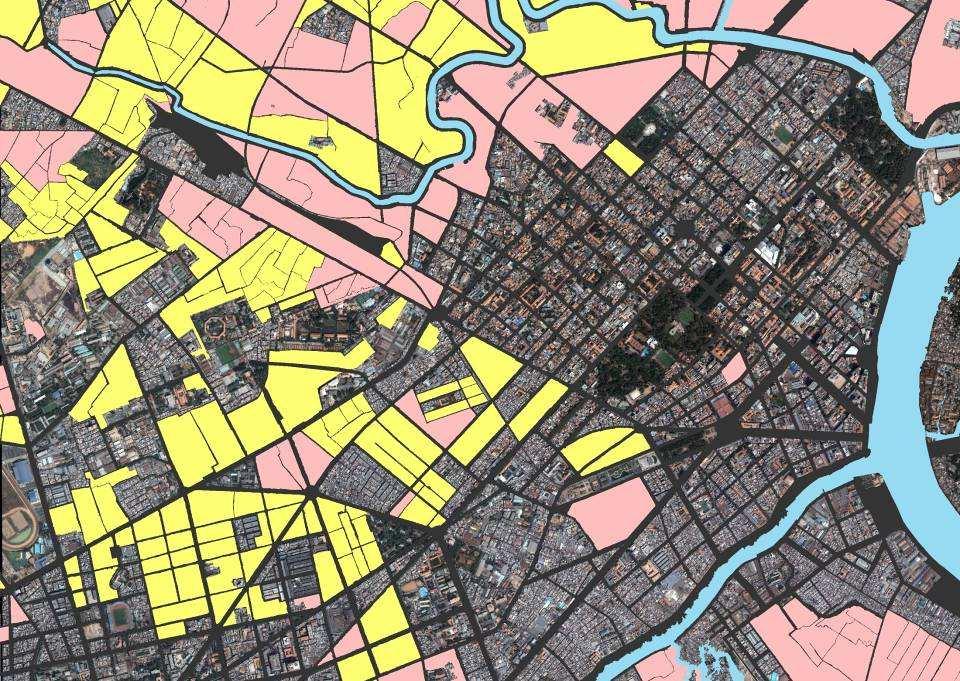
4 The Downscaling of Climate Change Impacts Global Climate Change Local Climate Change Land-Use Map 1:25000


5 Cooperation between AF1 Urban Environment and DONRE HCMC Legend LUC WATER PADDY LAND LUK REMAINING WATER PADDY LAND CON NATURAL GRASSLAND COT PLANTED GRASSLAND LNC AGROFORESTRY BHK OTHER ANNUAL CROPS LNQ ORCHARD PLANTATION LNK OTHER PERENNIAL CROPS NKH OTHER AGRICULTURAL USE RSK LAND USE OF RECOVERING PRODUCTIVE FOREST RSM PLANTED PRODUCTION FOREST LAND RPT PLANTED PROTECTIVE FOREST LAND RPM AFFORESTED PROTECTED GREENBELT RPK LAND USE OF RECOVERING PROTECTIVE FOREST RPN LAND USE OF PROTECTIVE NATURAL FOREST TSN FRESHWATER AQUACULTURE TSL BRACKISH AND MARINE AQUACULTURE ONT RURAL RESIDENTIALS ODT URBAN RESIDENTIALS SKK INDUSTRIAL ZONES SKC PRODUCTION AND BUSINESS SKX QUARRY SITES RAC WASTE DUMPING AND TREATMENT SITES TON RELIGIOUS AND WORSHIP SITES TIN AREA OF TRADITIONAL BELIEFS Meeting at DONRE, HCMC - March 2009 Ü 0 2, Kilometers Dao Anh Kiet (Director), Nguyen Thi Cam Van (Head of Planning Division), Do Hoang Oanh (Deputy Head of Planning Division) Team members of WP-1 (Adaptation Planning Framework) and WP-1.4 (Urban Governance and Administrative Integration) DTS PUBLIC OFFICES DSN HISTORICAL SITE QPH MILITARY AREAS ANI SECURITY SITE LDT HISTORICAL HERITAGE SITES DTL IRRIGATION WORKS DNT ENERGY & COMMUNICATION INFRASTRUCTURE DVH PLACES OF CULTURAL ARTS DYT HOSPITALS AND HEALTH CENTRES DGD TRAINING AND EDUCATIONAL SITES DTT SPORTS SITE DCH MARKETS NTD CEMETRY MNC SURFACE WATER FOR SPECIFIC USE DND URBAN COMMERCIAL AGRICULTURAL SERVICE BCS UNUSED LAND
 of HCMC from DONRE (Manual) Geo-processing: Le Thanh Hoa (Head of GIS Lab, GIS & RS Application, USSH Faculty of")
6 GIS Data Transfer: Official Land-Use Plan (1:25.000) of HCMC from DONRE (Manual) Geo-processing: Le Thanh Hoa (Head of GIS Lab, GIS & RS Application, USSH Faculty of Geography) GIS-Data Conversion: Bentley Microstation >>>> ESRI ArcGIS
 P roject Leader: WP: WP Leader: Geoprocesing: Cartography: Source: BTU Cottbus Adaptation Planning Framework Dr.")
7 BMBF Megacity Research Project TP. Ho C hi Minh (HCMC) P roject Leader: WP: WP Leader: Geoprocesing: Cartography: Source: BTU Cottbus Adaptation Planning Framework Dr. Harry Storch Le T hanh Hoa (USSH, Geography Dept.) Hendrik Rujner Department of Natural Resources and Environment HCMC March 2009
8 The Downscaling of Climate Change Impacts Global Climate Change Local Climate Change Land-Use Map 1:25,000 Street-Block Level

9
10

11

12

13
14 Block level as an appropriate spatial resolution based on Ho Chi Minh City's street network Ideal spatial foundation for an urban adaptation planning system
15 The Downscaling of Climate Change Impacts Global Climate Change Local Climate Change Land-Use Map 1:25000 Street-Block Level Urban Structure Types


16 Typology Description Example Card No.1 Name: Shop house large blocks with small inner road networks and pedestrian pathways Site visits of the WP1 Team Groundtruthing Urban Typologies

17
18 Informal
19 Informal -Hotel
20 Informal -Hotel Colonial Villa
21 Informal -Hotel Colonial Villa High-dense Apartments
22 Informal -Hotel Colonial Villa High-dense Apartments Colonial Building
23 Informal -Hotel Colonial Villa High-dense Apartments Colonial Building Colonial Mix

24 Informal -Hotel Colonial Villa High-dense Apartments Colonial Building Colonial Mix Sport sites
25 Informal -Hotel Colonial Villa High-dense Apartments Colonial Building Colonial Mix Sport sites Green Open Spaces
26 Informal -Hotel Colonial Villa High-dense Apartments Colonial Building Colonial Mix Sport sites Green Open Spaces Industry
27 Informal -Hotel Colonial Villa High-dense Apartments Colonial Building Colonial Mix Sport sites Green Open Spaces Industry Industry-shophouse
28 Informal -Hotel Colonial Villa High-dense Apartments Colonial Building Colonial Mix Sport sites Green Open Spaces Industry Industry-shophouse 1950/60s
29 Informal -Hotel Colonial Villa High-dense Apartments Colonial Building Colonial Mix Sport sites Green Open Spaces Industry Industry-shophouse 1950/60s High rise
30 Informal -Hotel Colonial Villa High-dense Apartments Colonial Building Colonial Mix Sport sites Green Open Spaces Industry Industry-shophouse 1950/60s High rise -high dense A
31 Informal -Hotel Colonial Villa High-dense Apartments Colonial Building Colonial Mix Sport sites Green Open Spaces Industry Industry-shophouse 1950/60s High rise -high dense A /industry
32 Informal -Hotel Colonial Villa High-dense Apartments Colonial Building Colonial Mix Sport sites Green Open Spaces Industry Industry-shophouse 1950/60s High rise -high dense A /industry /1950/60s
33 Informal -Hotel Colonial Villa High-dense Apartments Colonial Building Colonial Mix Sport sites Green Open Spaces Industry Industry-shophouse 1950/60s High rise -high dense A /industry /1950/60s /high rise
34 Informal shophouse/1950/60s Informal -Hotel Colonial Villa High-dense Apartments Colonial Building Colonial Mix Sport sites Green Open Spaces Industry Industry-shophouse 1950/60s High rise -high dense A /industry /1950/60s /high rise
35 Informal shophouse/1950/60s mix /high rise Informal -Hotel Colonial Villa High-dense Apartments Colonial Building Colonial Mix Sport sites Green Open Spaces Industry Industry-shophouse 1950/60s High rise -high dense A /industry /1950/60s /high rise
36 Informal shophouse/1950/60s mix /high rise Modern Villa/ high dense APT Informal -Hotel Colonial Villa High-dense APT Colonial Building Colonial Mix Sport sites Green Open Spaces Industry Industry-shophouse 1950/60s High rise -high dense A /industry /1950/60s /high rise
37 Informal shophouse/1950/60s mix /high rise Modern Villa/ high dense APT Cononial with adjacent GOS Informal -Hotel Colonial Villa High-dense APT Colonial Building Colonial Mix Sport sites Green Open Spaces Industry Industry-shophouse 1950/60s High rise -high dense A /industry /1950/60s /high rise
38 Informal shophouse/1950/60s mix /high rise Modern Villa/ high dense APT Cononial with adjacent GOS Cononial mix with high rise Informal -Hotel Colonial Villa High-dense APT Colonial Building Colonial Mix Sport sites Green Open Spaces Industry Industry-shophouse 1950/60s High rise -high dense A /industry /1950/60s /high rise
39 Informal shophouse/1950/60s mix /high rise Modern Villa/ high dense APT Cononial with adjacent GOS Cononial mix with high rise Informal -Hotel Colonial Villa High-dense APT Colonial Building Colonial Mix Sport sites Green Open Spaces Industry Industry-shophouse 1950/60s High rise -high dense A /industry /1950/60s /high rise

40

41
42 The Downscaling of Climate Change Impacts Global Climate Change Local Climate Change Land-Use Map 1:25,000 Urban Energy Urban Climate Street-Block Level Urban Transport Urban Flooding Urban Structure Types Environmental Impacts indicators Energetic & Climatic Efficiency indicators Exposure and resilience indicators
43 Summary Administrative cooperation: Department of Natural Resources and Environment, HCMC Common spatial working platform for AF 1: Reintegration of Research results based at DONRE and other planning authorities. Urban Structure Type Approach: Successful completion of case study area. Scientific cooperation: joint GIS data management with Dept. of Geography USSH Additional examples of cooperation in the following AF1 presentations
44 Thanks for your attention! > > > Harry S T O R C H > > > Brandenburg University of Technology Cottbus - Enviromental Planning
Megacity Research Project TP. Ho Chi Minh Adaptation to Global Climate Change in Vietnam: Integrative Urban and Environmental Planning Framework
 1. Organization 2. Global Warming 3. Starting Phase 4. Results, Transdisciplinarity, Low-Rise High Density 5. Risk of Flooding 6. Partners 7. Action Field 1 8. Action Field 2 9. Urban Development Trends
Copernicus Overview. Major Emergency Management Conference Athlone 2017
 Copernicus Overview Major Emergency Management Conference Athlone 2017 Copernicus is a European programme implemented by the European Commission. The services address six thematic areas: land, marine,
Introduction into Work Package Urban Flooding of the BMBF Megacity Research Project TP. Ho Chi Minh
 EnviroInfo 2009 (Berlin) Environmental Informatics and Industrial Environmental Protection: Concepts, Methods and Tools Introduction into Work Package Urban Flooding of the BMBF Megacity Research Project
Spatial information in strategic city planning - Zagreb experience. Darko Šiško City office for strategic planning, Zagreb
 Spatial information in strategic city planning - Zagreb experience Darko Šiško City office for strategic planning, Zagreb Overview Strategic city planning GI tools and trends Spatial data for strategic
FINANCIAL PERFORMANCE OF UTTAR PRADESH DURING TENTH PLAN
 FINANCIAL PERFORMANCE OF UTTAR PRADESH DURING TENTH PLAN Sl. Tenth Plan - 2002-07 Projected Annual Plan - 2002-03 Annual Plan - 2003-04 1. 2. 3. 4. 5. 6. 7. 8. 9. I Agriculture & Allied Activities 1. Crop
Socials Studies. Chapter 3 Canada s People 3.0-Human Geography
 Socials Studies Chapter 3 Canada s People 3.0-Human Geography Physical Geography Study of the natural features of the Earth s surface including landforms, climate, ocean currents and flora and fauna Human
Joanne N. Halls, PhD Dept. of Geography & Geology David Kirk Information Technology Services
 Joanne N. Halls, PhD Dept. of Geography & Geology David Kirk Information Technology Services Geographic Information Systems manage and analyze data to solve spatial problems. Real World Abstraction Analysis
CENSUS MAPPING WITH GIS IN NAMIBIA. BY Mrs. Ottilie Mwazi Central Bureau of Statistics Tel: October 2007
 CENSUS MAPPING WITH GIS IN NAMIBIA BY Mrs. Ottilie Mwazi Central Bureau of Statistics E-mail: omwazi@npc.gov.na Tel: + 264 61 283 4060 October 2007 Content of Presentation HISTORICAL BACKGROUND OF CENSUS
Geospatial Technologies for Resources Planning & Management
 Geospatial Technologies for Resources Planning & Management Lal Samarakoon, PhD Director, Geoinformatics Center Asian Institute of Technology, Thailand Content Geoinformatics for SDG Information Integration
Making maps: Traditions and perceptions in Europe. European spatial planning and cartographic representations
 ESPON Create Europe! Making maps: Traditions and perceptions in Europe Dr. Stefanie Dühr University of the West of England, Bristol, UK European spatial planning and cartographic representations Scenarios.
Making space for a more foundational construction sector in Brussels
 Making space for a more foundational construction sector in Brussels Sarah De Boeck, David Bassens & Michael Ryckewaert Social innovation in the Foundational Economy Cardiff, 5 th of September 2018 1.
Climate Change and the Resilience of Megacities in South-East-Asia Creating Risk-Based Climate Change Information for Ho Chi Minh City s Settlements
 reviewed paper Climate Change and the Resilience of Megacities in South-East-Asia Creating Risk-Based Climate Change Information for Ho Chi Minh City s Settlements Harry Storch, Nigel Downes, Kiduk Moon
APPLICATION OF REMOTE SENSING IN LAND USE CHANGE PATTERN IN DA NANG CITY, VIETNAM
 APPLICATION OF REMOTE SENSING IN LAND USE CHANGE PATTERN IN DA NANG CITY, VIETNAM Tran Thi An 1 and Vu Anh Tuan 2 1 Department of Geography - Danang University of Education 41 Le Duan, Danang, Vietnam
Exploring GIS Potential for Northwestern Ontario Land Information Ontario
 Exploring GIS Potential for Northwestern Ontario Land Information Ontario May 13, 2015 The LIO Vision LIO Vision: That all geographic information about Ontario is fully integrated and accessible LIO Goal:
Developing urban ecosystem accounts for Great Britain. Emily Connors Head of Natural Capital Accounting Office for National Statistics (UK)
") Developing urban ecosystem accounts for Great Britain Emily Connors Head of Natural Capital Accounting Office for National Statistics (UK) UN 2014 UN 2014 ONS 2017 UK motivation 54% 82% 5,900 Of the world
Developing urban ecosystem accounts for Great Britain Emily Connors Head of Natural Capital Accounting Office for National Statistics (UK) UN 2014 UN 2014 ONS 2017 UK motivation 54% 82% 5,900 Of the world
Spatial multicriteria analysis for home buyers
 Spatial multicriteria analysis for home buyers Xavier Albacete University of Eastern Finland, Department of Environmental Science, Research Group of Environmental Informatics, Yliopistoranta 1 E, P.O.
Grade Level, Course Third Grade Social Studies PLSD Balanced Assessment Practices. Type* DOK
 Unit Guides Assessment Items Indic ator s Concept Standard Curricular Indicator DOK Type* SR CR PB Assessment Questions # DOK Level 1E 1M 1H 2E 2M 2H 3E 3M 3H Civics Students will develop and apply the
Dar es Salaam - Reality Check Workshop
 Dar es Salaam - Reality Check Workshop hosted by GIZ and Dar es Salaam City Council Introduction: Key Urban Characteristics of Dar es Salaam Challenges and Opportunities for Resilient Development in the
Oman NSDI Supporting Economic Development. Saud Al-Nofli Director of Spatial Data Directorate General of NSDI, NCSI
 Oman NSDI Supporting Economic Development 2017 Saud Al-Nofli Director of Spatial Data Directorate General of NSDI, NCSI "It s critical to make correct decisions the first time to optimize the Investments
TOWARDS CLIMATE-RESILIENT COASTAL MANAGEMENT: OPPORTUNITIES FOR IMPROVED ICZM IN BELIZE
 TOWARDS CLIMATE-RESILIENT COASTAL MANAGEMENT: OPPORTUNITIES FOR IMPROVED ICZM IN BELIZE CHANTALLE SAMUELS Coastal Zone Management Authority and Institute The Caribbean Community Climate Change Centre VULNERABILITY
Progress and Land-Use Characteristics of Urban Sprawl in Busan Metropolitan City using Remote sensing and GIS
 Progress and Land-Use Characteristics of Urban Sprawl in Busan Metropolitan City using Remote sensing and GIS Homyung Park, Taekyung Baek, Yongeun Shin, Hungkwan Kim ABSTRACT Satellite image is very usefully
Calculating Land Values by Using Advanced Statistical Approaches in Pendik
 Presented at the FIG Congress 2018, May 6-11, 2018 in Istanbul, Turkey Calculating Land Values by Using Advanced Statistical Approaches in Pendik Prof. Dr. Arif Cagdas AYDINOGLU Ress. Asst. Rabia BOVKIR
Exploring the spatial-temporal linkages of climate response and rapid urban growth in Ho Chi Minh City
 Exploring the spatial-temporal linkages of climate response and rapid urban growth in Ho Chi Minh City 1 Introduction and Problem Overview In general, Asian cities located in deltaic regions tend to exhibit
Populations effected by flood top ten districts
 2050 - Populations effected by flood top ten districts 14 Extreme A2 Extreme A2 with dyke District Area (Ha) Population 2050 People affected Percent area affected People affected Percent area affected
ENV208/ENV508 Applied GIS. Week 1: What is GIS?
 ENV208/ENV508 Applied GIS Week 1: What is GIS? 1 WHAT IS GIS? A GIS integrates hardware, software, and data for capturing, managing, analyzing, and displaying all forms of geographically referenced information.
AHEAD OF THE STORM: Extreme Weather Resilience in the City of Toronto
 AHEAD OF THE STORM: Extreme Weather Resilience in the City of Toronto David MacLeod Toronto Environment and Energy Office Environmental Applied Science and Management Symposium 2013 March 21, 2013 Ahead
The UN-GGIM: Europe core data initiative to encourage Geographic information supporting Sustainable Development Goals Dominique Laurent, France
 INSPIRE conference Strasbourg 6 September 2017 The UN-GGIM: Europe core data initiative to encourage Geographic information supporting Sustainable Development Goals Dominique Laurent, France Introduction
Use of Geospatial data for disaster managements
 Use of Geospatial data for disaster managements Source: http://alertsystemsgroup.com Instructor : Professor Dr. Yuji Murayama Teaching Assistant : Manjula Ranagalage What is GIS? A powerful set of tools
Assessing the benefit of green infrastructure/wsud on urban microclimate
 Supporting the strategic planning of City of Unley (SA) towards a water sensitive city by quantifying the urban microclimate benefits using the Water Sensitive Cities Modelling Toolkit A Collaboration
Welcome to GCSE Geography. Where will it take us today?
 Welcome to GCSE Geography Where will it take us today? Urban Futures Dynamic Development Resource Reliance UK in the 21 st Century Global Hazards Changing Climate Distinctive Landscapes Sustaining Ecosystems
CAN THO URBAN DEVELOPMENT AND RESILIENCE PROJECT
 CAN THO URBAN DEVELOPMENT AND RESILIENCE PROJECT 1 Phnom Penh Can Tho City HCM City EAST SEA 2 1 3 Highest Water Level WATER LEVEL RAISE IN CAN THO DURING LAST 40 YEARS 4 2 Land subsidence a threat that
Chapter 10 Human Settlement Geography Book 1 Class 12
 CHAPTER 10 HUMAN SETTLEMENTS 1. RURAL, SUB URBAN AND URBAN SETTLEMENTS: This classification is common worldwide but the criteria differ from country to country. 5. Criteria for classification differs from
European Regional and Urban Statistics
 European Regional and Urban Statistics Dr. Berthold Feldmann berthold.feldmann@ec.europa.eu Eurostat Structure of the talk Regional statistics in the EU The tasks of Eurostat Regional statistics Urban
Cambridge International Examinations Cambridge International General Certificate of Secondary Education
 Cambridge International Examinations Cambridge International General Certificate of Secondary Education *86769654* GEOGRAPHY 46/4 Paper 4 Alternative to Coursework May/June 4 Candidates answer on the Question
Declaration Population and culture
 Declaration Population and culture The ministers of the parties to the Alpine Convention regard the socio-economic and socio-cultural aspects mentioned in Article 2, Paragraph 2, Item a., as being central
GIS Geographical Information Systems. GIS Management
 GIS Geographical Information Systems GIS Management Difficulties on establishing a GIS Funding GIS Determining Project Standards Data Gathering Map Development Recruiting GIS Professionals Educating Staff
International Symposium on Natural Disaster Mitigation. Local vulnerability assessment of landslides and debris flows
 International Symposium on Natural Disaster Mitigation of landslides and debris flows Lessons learnt from Cam Pha town and Van Don district, Quang Ninh province, Vietnam Nguyen Quoc Phi Faculty of Environment
Vulnerability Mapping for Disaster Assessment Using ArcGIS Tools and Techniques for Mumbai City, India
 Vulnerability Mapping for Disaster Assessment Using ArcGIS Tools and Techniques for Mumbai City, India Reshma Raskar-Phule Assistant Professor, Department of Civil Engineering, Sardar Patel College of
CLLD Cooperation OFFER
 Title of the proposed project (English) CLLD Cooperation OFFER PARKS PROTECTION III - Management, Protection and Economic Development in Protected Areas Type of project (select as many as you want) Cooperation
Urban-Rural spatial classification of Finland
 Urban-Rural spatial classification of Finland Finnish Environment Institute SYKE The geographical information-based area classification system has been created by the Finnish Environment Institute and
CK107 BA in Geographical and Archaeological Sciences
 CK107 BA in Geographical and Archaeological Sciences CK107 BA in Geographical and Archaeological Science Geography and Archaeology are closely related disciplines, concerned with concepts of time and space
INTEGRATING CLIMATE VULNERABILITY & RISK ASSESSMENT INTO URBAN SPATIAL PLANNING PROCESS
 INTEGRATING CLIMATE VULNERABILITY & RISK ASSESSMENT INTO URBAN SPATIAL PLANNING PROCESS (CASE STUDY: BLITAR CITY, EAST JAVA, INDONESIA) SHINTA MICHIKO PUTERI, ST, MT. DR. IR. DENNY ZULKAIDI, MUP. WRITER
Spatial analysis of locational conflicts
 Spatial analysis of locational conflicts Case study: Locational conflicts generated by the expansion of built up surfaces in the northern area of Bucharest, Romania Diana A. ONOSE 1, Cristian I. IOJĂ 2,
Social Studies Grade 2 - Building a Society
 Social Studies Grade 2 - Building a Society Description The second grade curriculum provides students with a broad view of the political units around them, specifically their town, state, and country.
Tackling urban sprawl: towards a compact model of cities? David Ludlow University of the West of England (UWE) 19 June 2014
 19 June 2014") Tackling urban sprawl: towards a compact model of cities? David Ludlow University of the West of England (UWE) 19 June 2014 Impacts on Natural & Protected Areas why sprawl matters? Sprawl creates environmental,
Tackling urban sprawl: towards a compact model of cities? David Ludlow University of the West of England (UWE) 19 June 2014 Impacts on Natural & Protected Areas why sprawl matters? Sprawl creates environmental,
Geospatial Data, Services, and Products. National Surveying, mapping and geospatial conference
 Geospatial Data, Services, and Products Federal Programs -- USDA NRCS National Surveying, mapping and geospatial conference March 15, 2016 NRCS Applications using Geosaptial Products & Services Field
Why Geography Matters
 Why Geography Matters Vocabulary words geography relative location absolute location physical feature human feature region modify adapt cause effect geography: The study of the Earth s physical and human
The platform is the means, not the end goal
 The platform is the means, not the end goal + Complete analytics platform at an accessible price point Compliments existing workflows by integrating with the new intelligent farm equipment. The goal is
The Contested Cultural Landscape of a Lebanese Border Town: MARJA AYOUN
 The Contested Cultural Landscape of a Lebanese Border Town: MARJA AYOUN IBD 2013 FNAS MAY 2013 Dr. Christine Mady, City & Regional Planning NDU -FAAD In this Presentation A PLANNING PERSPECTIVE INTRODUCING
CERTIFIED RESOLUTION. introduction: and dated May 29, 2017, as attached, as appropriate
 15322 Buena Vista Avenue, White Rock BC, Canada V4B 1Y6 www.whiterockcity.ca City of White Rock P: 604.541.22121 F: 604.541.9348 /2tC% City Clerk s Office IT E ROC K June 13,2017 Stephanie Lam, Deputy
Mutah university faculty of Social Sciences The Study plan of the department of Geography 2006/2007
 Mutah university faculty of Social Sciences The Study plan of the department of Geography 2006/2007 Requirements university compulsory 22 Credit hours Course No Credit hours Prerequisite Requirements Faculty
Bishkek City Development Agency. Urban Planning Bishkek
 Bishkek City Development Agency Urban Planning Bishkek Bishkek City Development Agency Official name City budget Population Area GRP Import value Export value External trade turnover Foreign direct investments
GEO-INFORMATICS AND SPACE TECHNOLOGY FOR PROPERTIES DIGITAL TAX MAP : CASE STUDY ON LOCAL ADMINISTRATIVE WONG KONG MUNICIPALITY, PHITSANULOK, THAILAND
 GEO-INFORMATICS AND SPACE TECHNOLOGY FOR PROPERTIES DIGITAL TAX MAP : CASE STUDY ON LOCAL ADMINISTRATIVE WONG KONG MUNICIPALITY, PHITSANULOK, THAILAND Vicharn Amarakul Regional Center of Geo-Informatics
Opportunities and challenges of HCMC in the process of development
 Opportunities and challenges of HCMC in the process of development Lê Văn Thành HIDS HCMC, Sept. 16-17, 2009 Contents The city starting point Achievement and difficulties Development perspective and goals
FLOOD HAZARD MAPPING OF DHAKA-NARAYANGANJ-DEMRA (DND) PROJECT USING GEO-INFORMATICS TOOLS
 PROJECT USING GEO-INFORMATICS TOOLS") FLOOD HAZARD MAPPING OF DHAKA-NARAYANGANJ-DEMRA (DND) PROJECT USING GEO-INFORMATICS TOOLS Md. Aminul Islam MEE07178 Supervisor: Prof. Kuniyoshi TAKEUCHI ABSTRACT Dhaka-Narayanganj-Demra (DND) Project is
FLOOD HAZARD MAPPING OF DHAKA-NARAYANGANJ-DEMRA (DND) PROJECT USING GEO-INFORMATICS TOOLS Md. Aminul Islam MEE07178 Supervisor: Prof. Kuniyoshi TAKEUCHI ABSTRACT Dhaka-Narayanganj-Demra (DND) Project is
Applying ArcGIS Online for Establishing Hanoi Agriculture Map
 Applying ArcGIS Online for Establishing Hanoi Agriculture Map Thanh Xuan Nguyen Geography Department Hanoi National University of Education mrthanhxuan@gmail.com Tien Yin Chou GIS Research Center Feng
Land Cover Classification Mapping & its uses for Planning
 Land Cover Classification Mapping & its uses for Planning What is Land Cover Classification Mapping? Examples of an actual product Why use Land Cover Classification Mapping for planning? Possible uses
Land Administration and Cadastre
 Geomatics play a major role in hydropower, land and water resources and other infrastructure projects. Lahmeyer International s (LI) worldwide projects require a wide range of approaches to the integration
GIS AND REMOTE SENSING FOR OPEN SPACE PROTECTION ENVIRONMENTAL MANAGEMENT DEPARTMENT
 GIS AND REMOTE SENSING FOR OPEN SPACE PROTECTION ENVIRONMENTAL MANAGEMENT DEPARTMENT 22 nd May 2009 1 Introduction It is said that more than 80% of the City s activities throughout the world are spatially
Data Dictionary Hudson River Features: Estuary shoreline Flood scenario Emergency Services: Police stations Fire stations EMS
 Data Dictionary Hudson River Features: Estuary shoreline This data layer represents the border of the Hudson River in our study area. New York State Department of Environmental Conservation. 2009. Hudson
IMPLEMENTING GOVERNMENT-WIDE ENTERPRISE GIS; THE FEDERATED MODEL
 IMPLEMENTING GOVERNMENT-WIDE ENTERPRISE GIS; THE FEDERATED MODEL James E. Mitchell, Ph. D. IT GIS Manager Louisiana Department of Transportation and Development presented at the ESRI International Users
APPENDIX I - AREA PLANS
 ROUTE 37 WEST LAND USE PLAN ROUTE 37 WEST LAND USE PLAN Recent land use decisions and development trends have drawn attention to the land within the Route 37 western by-pass area between Route 50 and
CONFERENCE STATEMENT
 CONFERENCE STATEMENT We, the elected representatives from Canada, Denmark/Greenland, Finland, Iceland, Norway, Russia, Sweden and the United States of America; In collaboration with the indigenous peoples
A new type of RICEPOTS
 A new type of RICEPOTS Alan Parkinson Geography teaching resource College Crown Copyright and Database Right 2014. Ordnance Survey (Digimap Licence) This is one of a series of teaching resources for use
Geographic Information Infrastructure and Policy Framework for Sustainable Mountain Development in the Hindu Kush-Himalayas
 Geo SMART ASIA 2017 22-24 August, Kualalampur Geographic Information Infrastructure and Policy Framework for Sustainable Mountain Development in the Hindu Kush-Himalayas Basanta Shrestha, Director Strategic
Mapping Secondary Cities for Resiliency and Emergency Preparedness
 Mapping Secondary Cities for Resiliency and Emergency Preparedness Secondary Cities Geospatial Training Workshop Pilot Project: Cusco, Peru June 29 July 3 2015 WHO ARE WE? Office of the Geographer (GGI)
WORLD DAY TO COMBAT DESERTIFICATION 2018 IN MONGOLIA
 WORLD DAY TO COMBAT DESERTIFICATION 2018 IN MONGOLIA This year the WDCD slogan was Land has true value. Invest in it to address the importance of sustainable land use, land degradation prevention and its
SITMUN: Cooperating to Build Local SDIs in the Barcelona Region
 SITMUN: Cooperating to Build Local SDIs in the Barcelona Region Diputació de Barcelona Territory and Sustainability Area Territorial Information Systems Department INSPIRE CONFERENCE Barcelona, September
Legal problems of environmental management. Spatial planning and space management. M. Gajewski 2014 / 2015
 Legal problems of environmental management Spatial planning and space management M. Gajewski 2014 / 2015 Course contents (in brief) Constitutional basis of the environment protection system. General principles
From Vulnerability to Resilience And the Tools to Get There. Out of Harm s Way Partnership for the Delaware Estuary August 1, 2012
 From Vulnerability to Resilience And the Tools to Get There Out of Harm s Way Partnership for the Delaware Estuary August 1, 2012 Today s Presentation Tour of New Jersey Challenges Definitions so we re
Remote Sensing and EO activities at the University of Turku
 Remote Sensing and EO activities at the University of Turku Niina Käyhkö Associate Professor Department of Geography and Geology GEO meeting/syke May 23rd, 2018 Geospatial competence at the University
Most people used to live like this
 Urbanization Most people used to live like this Increasingly people live like this. For the first time in history, there are now more urban residents than rural residents. Land Cover & Land Use Land cover
How the science of cities can help European policy makers: new analysis and perspectives
 How the science of cities can help European policy makers: new analysis and perspectives By Lewis Dijkstra, PhD Deputy Head of the Economic Analysis Unit, DG Regional and European Commission Overview Data
Disaster Management in Republic of Korea
 The Third UN-GGIM-AP Plenary Meeting Disaster Management in Republic of Korea ~Coordination among NGIA & Other Related Organizations and Recommendations~ Bali Indonesia 10 November 2014 Sanghoon Lee, Ph.D.
Overview of proposed approach to the Desktop Study to inform discussion
 LTAS Phase 2: Climate Change Implications for the Human Settlements sector in South Africa Overview of proposed approach to the Desktop Study to inform discussion Project Team Project Lead: Crispian Olver
Esri s Living Atlas of the World Community Maps
 Esri s Living Atlas of the World Community Maps Seth Sarakaitis Wednesday May 7, 2014 ArcGIS Living Atlas Concept Living Atlas Content Tour Contributing to the Living Atlas (Community Maps) Seth Sarakaitis
PROMOTING NATURE CONSERVATION AND SUSTAINABLE AGRICULTURAL DEVELOPMENT IN THE RURAL AREAS OF HONG KONG
 1 PROMOTING NATURE CONSERVATION AND SUSTAINABLE AGRICULTURAL DEVELOPMENT IN THE RURAL AREAS OF HONG KONG Director of Agriculture, Fisheries and Conservation Dr. LEUNG Siu-fai A STONE S THROW AWAY FROM
Excel Geomatics. Rajesh Paul Excel Geomatics Pvt. Ltd., Noida February, 2015 India Geospatial Forum, Hyderabad
 Excel Geomatics Geo-marketing for Product Sales and Customer Services Rajesh Paul Excel Geomatics Pvt. Ltd., Noida 10-12 February, 2015 India Geospatial Forum, Hyderabad Presentation Outline About Excel
Experience of Mexico in using GIS and spatial
 Experience of Mexico in using GIS and spatial data as a tool for data integration Francisco Javier Jimenez Nava Deputy General Director of Natural Resources and Environment Outline Introduction National
Application of high-resolution (10 m) DEM on Flood Disaster in 3D-GIS
 DEM on Flood Disaster in 3D-GIS") Risk Analysis V: Simulation and Hazard Mitigation 263 Application of high-resolution (10 m) DEM on Flood Disaster in 3D-GIS M. Mori Department of Information and Computer Science, Kinki University, Japan
Risk Analysis V: Simulation and Hazard Mitigation 263 Application of high-resolution (10 m) DEM on Flood Disaster in 3D-GIS M. Mori Department of Information and Computer Science, Kinki University, Japan
Regional Plan 4: Integrating Ecosystem Services Mapping into Regional Land Use Planning
 Rural-Urban Outlooks: Unlocking Synergies (ROBUST) ROBUST receives funding from the European Union s Horizon 2020 research and innovation programme under grant agreement No 727988.* October 2018 Natural
St. Mary s County Comprehensive Zoning Ordinance. Article 5. REGULATION OF USES. Schedule 50.4 Use Classifications. Legend
 St. Mary s County Comprehensive Zoning Ordinance Article 5. REGULATION OF USES Schedule 50.4 Use Classifications Legend P Use is permitted in accordance with Chapter 51 General Standards L Use is permitted
M14/3/GEOGR/SP2/ENG/TZ0/XX/Q GEOGRAPHY STANDARD LEVEL PAPER 2. Monday 19 May 2014 (morning) 1 hour 20 minutes INSTRUCTIONS TO CANDIDATES
 1 hour 20 minutes INSTRUCTIONS TO CANDIDATES") M14/3/GEOGR/SP2/ENG/TZ0/XX/Q 22145203 GEOGRAPHY STANDARD LEVEL PAPER 2 Monday 19 May 2014 (morning) 1 hour 20 minutes INSTRUCTIONS TO CANDIDATES Do not open this examination paper until instructed to do
M14/3/GEOGR/SP2/ENG/TZ0/XX/Q 22145203 GEOGRAPHY STANDARD LEVEL PAPER 2 Monday 19 May 2014 (morning) 1 hour 20 minutes INSTRUCTIONS TO CANDIDATES Do not open this examination paper until instructed to do
Climate Change Vulnerability Assessment in Thailand. Kampanart PiyathamrongchaI Naresuan University
 Climate Change Vulnerability Assessment in Thailand Kampanart PiyathamrongchaI Naresuan University Outline Background Objectives Concept and technique to assess climate change vulnerability Discussion
Sustainable Cities and Communities based on Indicators on Urbanization 地理国情监测技术. Prof. Dr. John W. Z. SHI The Hong Kong Polytechnic University
 IAEG- SDGs WG on Geospatial Information, 1 st Expert Group Meeting 12-14 Dec 2016 Mexico City Measure 地理国情监测技术 Sustainable Cities and Communities 专业 based on Indicators on Urbanization Prof. Dr. John W.
Dr Ozlem Adiyaman Earth Sciences and Geo-hazards Risk Reduction Section Division of Ecological and Earth Sciences ( ) NATURAL SCIENCES
 NATURAL SCIENCES") Earth Sciences and Geo-hazards Risk Reduction Section Earth observation with COPERNICUS to : protect, monitor, document, present and share our common heritage, our cultural and natural UNESCO World Heritage
Earth Sciences and Geo-hazards Risk Reduction Section Earth observation with COPERNICUS to : protect, monitor, document, present and share our common heritage, our cultural and natural UNESCO World Heritage
Global Atmospheric Circulation. Past climate change and natural causes. Global climate change and human activity
 GCSE Geography Edexcel B Revision Checklist Paper 1. Global Geographical Issues Topic 1. Hazardous Earth Key Idea I know/ understand The world s climate system Global Atmospheric Circulation Past climate
Looking at Communities: Comparing Urban and Rural Neighborhoods
 Looking at Communities: Comparing Urban and Rural Neighborhoods OVERVIEW & OBJECTIVES Our urban areas have become so dominant that frequently the children we teach have no connection with and very few
South Carolina Standards & Learning Science Grade: 2 - Adopted: 2014
 Main Criteria: South Carolina Standards & Learning Secondary Criteria: Subjects: Science, Social Studies Grade: 2 Correlation Options: Show Correlated South Carolina Standards & Learning Science Grade:
Advancing Geoscientific Capability. Geological Survey of Finland
 Advancing Geoscientific Capability Geological Survey of Finland GTK in brief The Geological Survey of Finland (GTK) is one of the largest European centres of excellence in assessment, research and the
Appendix C Fluvial Flood Hazards
 Appendix C Fluvial Flood Hazards Sea Level Rise Vulnerability Assessment and Adaptation Project March 2019 Contents Contents... i Figures... i Tables... i Definitions, Acronyms, & Abbreviations... ii
Land Accounts - The Canadian Experience
 Land Accounts - The Canadian Experience Development of a Geospatial database to measure the effect of human activity on the environment Who is doing Land Accounts Statistics Canada (national) Component
Investigation, assessment and warning zonation for landslides in the mountainous regions of Vietnam
 Investigation, assessment and warning zonation for landslides in the mountainous regions of Vietnam (State-Funded Landslide Project SFLP) Dr. Eng. Le Quoc Hung Add: 67 Chien Thang Street, Ha Dong District,
AP Human Geography Free-response Questions
 AP Human Geography Free-response Questions 2000-2010 2000-preliminary test 1. A student concludes from maps of world languages and religions that Western Europe has greater cultural diversity than the
EuroGEOSS Protected Areas Pilot
 EuroGEOSS Protected Areas Pilot Max Craglia European Commission Joint Research Centre Part 1: the present MyNatura2000 Mobile app. Awareness raising & volunteered data collection. Natura2000 covers 18%
 CLASSIFYING SMALL AREAS IN HANOI FO TitleLANSCAPE MANAGEMENT-BASED ON FACTOR CLUSTER ANALYSIS METHOD Author(s) Nguyen, Cao Huan; Nguyen, An Thinh; Sawaki, Masanori Annual Report of FY 2004, The Core Citation
CityGML & opendrive Urban Simulation Based on Open Standards
 CREATE MAINTAIN DISTRIBUTE 3D Mapping Solutions CityGML & opendrive Urban Simulation Based on Open Standards Dr.-Ing. Stefan Trometer virtualcitysystems GmbH virtualcitysystems Experts for 3D City Models
ANALYZING CITIES & POPULATION: POPULATION GEOGRAPHY
 ANALYZING CITIES & POPULATION: POPULATION GEOGRAPHY Population Geography Population Geography study of the number, contribution, and distribution of human populations Demography the study of the characteristics
Cities, AI, Design, & the Future Can Artificial Intelligence Improve Design Intelligence?
 March 27 th 28 Cities, AI, Design, & the Future Can Artificial Intelligence Improve Design Intelligence? Michael Batty m.batty@ucl.ac.uk @jmichaelbatty http://www.spatialcomplexcity.info/ http://www.casa.ucl.ac.uk/
Vulnerability of Bangladesh to Cyclones in a Changing Climate
 Vulnerability of Bangladesh to Cyclones in a Changing Climate Susmita Dasgupta Kiran Pandey Mainul Huq Zahirul Huq Khan M.M. Zahid Ahmed Nandan Mukherjee Malik Fida Khan 2010 Bangladesh: Tropical Cyclone