GIS AND REMOTE SENSING FOR OPEN SPACE PROTECTION ENVIRONMENTAL MANAGEMENT DEPARTMENT
|
|
|
- Dwight Palmer
- 5 years ago
- Views:
Transcription


1 GIS AND REMOTE SENSING FOR OPEN SPACE PROTECTION ENVIRONMENTAL MANAGEMENT DEPARTMENT 22 nd May
2 Introduction It is said that more than 80% of the City s activities throughout the world are spatially related. GEOGRAPHIC Conservation is about places - Andy Rowan, Ph.D. Almost everything that happens, happens somewhere. Paul A. Longley INFORMATION SYSTEM The new source of power is not money in the hands of a few but information in the hands of many. John Naisbitt, Megatrends A decision is a good as the Information that goes into it. John F. Boorout, Jr. 2
3 Contents to be covered in the presentation Decision Define problem Output GIS Process Define GIS criteria GIS Analysis Data Management And Verification Build OS Database 3
4 Define GIS Problem Developmental challenges: Pressure for development/ alienation of open spaces/ rapid loss of open space Development pressure specifically on the retention, conservation and expansion of the open space network Invasion of open spaces Inherited fragmented open space system Redress and equitable provisioning of open space Pollution and dumping Hazardous land uses e.g. sewage, mine dumps, slimes dams 4 Quality of open spaces
5 Define GIS Problem Information: Accuracy of database Level of detail of database Access to database Decision-making: Integration between decision-making in different departments Consistent decision making based on accepted criteria 5
6 Define GIS Problem (JMOSS Process) JMOSS I OS Policy OS Categories Capturing of OS Sourcing of OS datasets JMOSS II Management Strategy OS Verification (Groundtruthing) 6 Capturing of Brown OS Network OS Verification (Groundtruthing) OS Provision (Analysis) OS Integration with RSDF s OS MANAGEMENT FRAMEWORK Status Quo Policy Framework Regional OS Framework
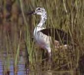
7 OS Categories PRIMARY OPEN SPACES MAIN CATEGORY Ecological open space Existing Desired Nature reserves Botanical gardens SUB-CATEGORIES Waterbodies (buffered by 50 m) Undeveloped ridges Bird sanctuaries Nature trails Areas of high conservation value (as determined by specialist ecologist) Areas with high habitat diversity (as determined by specialist ecologist) Areas with a low disturbance (as determined by specialist ecologist) Red Data fauna (from GDACEL) Red Data flora (from GDACEL) Natural land cover categories 7
8 8 SECONDARY OPEN SPACES MAIN CATEGORY Social open space Institutional Heritage Agricultural OS Categories Zoological gardens Sports facilities Recreational facilities Places of interest Places of worship Libraries Community centres SUB-CATEGORIES Municipal facilities Airports/airfields Educational facilities Public service facilities (e.g. police stations, post offices etc.) Health facilities (i.e. hospitals and clinics) Cemeteries Historical monuments Museums Art galleries Cemeteries of historical importance Archaeological sites Cultural sites Agricultural lands (including urban agriculture)
9 OS Categories TERTIARY OPEN SPACES MAIN CATEGORY SUB-CATEGORIES Refuse sites Mine dumps Prospective open space Slimes dams Landfill sites Mining land & quarries 9
 Waterbodies Ridges")
10 Build/Import Datasets (Existing Ecological OS) Waterbodies Ridges 10

11 Build/Import Datasets (Desired Ecological OS) Areas with Low Disturbance Habitat Diversity 11
12 Build/Import Datasets (Ecological Network) Ecological OS 12

13 13 Build/Import Datasets (Secondary OS)

14 14 Build/Import Datasets (Tertiary OS)

15 Data Management (OS Ownership) OS Categories Valuations Information Private/Public OS 15
 OS Categories")

16 Data Management (OS Zoning) OS Categories Zoning Information Zoning Required (YES/NO) 16


17 Data Management (OS Development Status) OS Categories Parks Database Aerial Photograph Developed/Undeveloped 17


18 Data Verification BIODIVERSITY ASSESSMENT Field verification of Natural Areas within the City Identification of all Animal and Plant Species 18
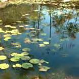
19 Data Verification WETLAND AUDIT A Retain, conserve and expand the open space network. Wetland status and functioning within the ecosystem C B E Region Hectares A D F B C D E G F G Total Hectares:
20 GIS Analysis The true Power of GIS lies in the analysis GIS analysis shows you: Patterns, Relationships, and Trends. in your geographic data that help you: understand how the world works, make the best choice from among options, plan for the future 20


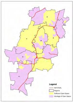
21 Open Space Provision GIS Analysis Calculation of OS hectares and Quantify within wards Provision of Openspaces International standard: 2.4ha/ 1000 people Provision of Openspaces X = OS/P*1000 Where by: X: is the ratio of openspces per 1000 people OS: is the total Ha of openspaces per ward P: is the total population of each ward Parks/OS Social OS 21
22 Outputs Table Format OPEN SPACE CATEGORY AREA (ha) % OF TOTAL AREA Ecological Existing Desired Social Institutional Heritage Agricultural Prospective Total
23 Outputs Graph Format Summary of OS Categories % Existing Ecological Desired Ecological Social Institutional Heritage Agricultural Prospective OS Categories
 OS")

24 Outputs (Map Format) OS Categories Conservation Value 24
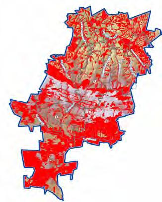
25 Outputs Biodiversity Hotspots OS Provision 25

26 26 Outputs
27 Decision-Making (DSS) Need for Decision Support System: Recognize the spatial environmental dataset as a strategic asset to the City Link to other City processes (i.e RSDF s) Easy accessibility of the OS database Regular and easy updating of the OS database Proper data management and maintenance KNOWLEDGE DECISION INFORMATION DATA 27

28 Remote Sensing Landuse 2004 Landuse


29 Remote Sensing Landcover
30 DISCUSSIONS / THANK YOU Makau Alfred Malatji Alfredmalatji@joburg.org.za
Developing urban ecosystem accounts for Great Britain. Emily Connors Head of Natural Capital Accounting Office for National Statistics (UK)
") Developing urban ecosystem accounts for Great Britain Emily Connors Head of Natural Capital Accounting Office for National Statistics (UK) UN 2014 UN 2014 ONS 2017 UK motivation 54% 82% 5,900 Of the world
Developing urban ecosystem accounts for Great Britain Emily Connors Head of Natural Capital Accounting Office for National Statistics (UK) UN 2014 UN 2014 ONS 2017 UK motivation 54% 82% 5,900 Of the world
WELCOME & INTRODUCTION
 MPA Management Capacity Building Training Module 1: WELCOME & INTRODUCTION Participants Distinguished Guests Welcome Site Overviews of MPAs represented Overview of Training Program What are Today s Objectives?
Mutah university faculty of Social Sciences The Study plan of the department of Geography 2006/2007
 Mutah university faculty of Social Sciences The Study plan of the department of Geography 2006/2007 Requirements university compulsory 22 Credit hours Course No Credit hours Prerequisite Requirements Faculty
CK107 BA in Geographical and Archaeological Sciences
 CK107 BA in Geographical and Archaeological Sciences CK107 BA in Geographical and Archaeological Science Geography and Archaeology are closely related disciplines, concerned with concepts of time and space
Legal problems of environmental management. Spatial planning and space management. M. Gajewski 2014 / 2015
 Legal problems of environmental management Spatial planning and space management M. Gajewski 2014 / 2015 Course contents (in brief) Constitutional basis of the environment protection system. General principles
Overview of Methods. Terrestrial areas that are most important for conservation Conservation
 Overview of Methods The goal of the Western Lake Erie Coastal Conservation Vision project (WLECCV) is to define where we should be working locally to optimally achieve regional conservation impact. The
COUNTY SPATIAL DATA INFRASTRUCTURE PRESENTATION: BY: GEOFREY CHERUIYOT NAIROBI CITY COUNTY
 . COUNTY SPATIAL DATA INFRASTRUCTURE PRESENTATION: BY: GEOFREY CHERUIYOT NAIROBI CITY COUNTY FRAMEWORK FOR AN INTEGRATED SPATIAL DATA INFRASTRUCTURE County GIS GIS : A computer based information system
THINK RICE! GRADE 3 STANDARDS ALIGNMENT
 THINK RICE! GRADE STANDARDS ALIGNMENT National Social Studies Standards Standard I: Culture Eplore and describe similarities and differences in the ways groups, societies, and cultures address similar
CHAPTER 4 HIGH LEVEL SPATIAL DEVELOPMENT FRAMEWORK (SDF) Page 95
 Page 95") CHAPTER 4 HIGH LEVEL SPATIAL DEVELOPMENT FRAMEWORK (SDF) Page 95 CHAPTER 4 HIGH LEVEL SPATIAL DEVELOPMENT FRAMEWORK 4.1 INTRODUCTION This chapter provides a high level overview of George Municipality s
CHAPTER 4 HIGH LEVEL SPATIAL DEVELOPMENT FRAMEWORK (SDF) Page 95 CHAPTER 4 HIGH LEVEL SPATIAL DEVELOPMENT FRAMEWORK 4.1 INTRODUCTION This chapter provides a high level overview of George Municipality s
EcoServ-GIS. EcoServ GIS Stage I. Why EcoServ GIS? 17/12/2012
 EcoServ-GIS Ecosystem Services Mapping: A Wildlife Trust GIS Toolkit to map ecosystem services at a county scale Dr Jonathan Winn Living Landscape Coordinator Durham Wildlife Trust Dr Chloe Bellamy Ecosystem
Strategies for biodiversity conservation
 Institute of Earth Systems University of Malta Strategies for biodiversity conservation Louis F. Cassar PhD Elisabeth Conrad PhD The conservation imperative: perspective Biodiversity hotspot High endemism
Data Dictionary for Network of Conservation Areas Transcription Reports from the Colorado Natural Heritage Program
 Data Dictionary for Network of Conservation Areas Transcription Reports from the Colorado Natural Heritage Program This Data Dictionary defines terms used in Network of Conservation Areas (NCA) Reports
GIS and Remote Sensing
 Spring School Land use and the vulnerability of socio-ecosystems to climate change: remote sensing and modelling techniques GIS and Remote Sensing Katerina Tzavella Project Researcher PhD candidate Technology
DC Educational Standards Science Grade: 3 - Adopted: From Molecules to Organisms: Structures and Processes
 Main Criteria: DC Educational Standards Secondary Criteria: Subjects: Science, Social Studies Grade: 3 Correlation Options: Show Correlated ESSENTIAL 3-LS1. DC Educational Standards Science Grade: 3 -
EcoServ-GIS. Ecosystem Services Mapping: A Wildlife Trust GIS Toolkit to map ecosystem services at a county scale
 EcoServ-GIS Ecosystem Services Mapping: A Wildlife Trust GIS Toolkit to map ecosystem services at a county scale Dr Jonathan Winn Living Landscape Coordinator Durham Wildlife Trust Dr Chloe Bellamy Ecosystem
STAGE 2 GEOGRAPHY: Natural environments
 STAGE 2 GEOGRAPHY: Natural environments Focus area: The Earth s environment Different environments Significance of environments Key inquiry questions How does the environment support the lives of people
Most people used to live like this
 Urbanization Most people used to live like this Increasingly people live like this. For the first time in history, there are now more urban residents than rural residents. Land Cover & Land Use Land cover
Resolution XIII.23. Wetlands in the Arctic and sub-arctic
 13th Meeting of the Conference of the Contracting Parties to the Ramsar Convention on Wetlands Wetlands for a Sustainable Urban Future Dubai, United Arab Emirates, 21-29 October 2018 Resolution XIII.23
New York State Learning Standards and Core Curriculum Science Grade: 3 - Adopted: Interdependent Relationships in Ecosystems
 Main Criteria: New York State Learning Standards and Core Curriculum Secondary Criteria: Subjects: Science, Social Studies Grade: 3 Correlation Options: Show Correlated New York State Learning Standards
Heritage and Cultural Tourism Management
 Unit 34: Heritage and Cultural Tourism Management Unit code: L/601/1757 QCF level: 4 Credit value: 15 Aim The aim of this unit is to enable learners to gain understanding of the heritage and cultural,
COMMUNITY SERVICE AREA
 INSTITUTE FOR TRIBAL ENVIRONMENTAL PROFESSIONALS Tribal Waste and Response Assistance Program (TWRAP) Developing and Implementing a Tribal Integrated Solid Waste Management Plan April 12-14, 2016 Palm
APPENDIX PHASE 1 GREEN INFRASTRUCTURE FRAMEWORK
 APPENDIX PHASE 1 GREEN INFRASTRUCTURE FRAMEWORK KANSAS MISSOURI CONTENTS A DATA WISHLIST 4 B PRECEDENTS 7 C WORKSHOP MATERIALS 13 D ANALYSIS PROCESS 124 E ATLAS & PLAYBOOK DETAILS 156 F POLICY ANALYSIS
Wisconsin Academic Standards Science Grade: K - Adopted: 1998
 Main Criteria: Wisconsin Academic Standards Secondary Criteria: Subjects: Science, Social Studies Grade: K Correlation Options: Show Correlated Wisconsin Academic Standards Science Grade: K - Adopted:
presents challenges related to utility infrastructure planning. Many of these challenges
 1 Introduction: - a. Purpose According to U.S. Census Bureau the population of stark county was 367,585 in 1990, and in 2000 it was increase to 378,098. Thus County is experiencing a growth that presents
SIF_7.1_v2. Indicator. Measurement. What should the measurement tell us?
 Indicator 7 Area of natural and semi-natural habitat Measurement 7.1 Area of natural and semi-natural habitat What should the measurement tell us? Natural habitats are considered the land and water areas
Kyoto and Carbon Initiative - the Ramsar / Wetlands International perspective
 Kyoto and Carbon Initiative - the Ramsar / Wetlands International perspective (the thoughts of Max Finlayson, as interpreted by John Lowry) Broad Requirements Guideline(s) for delineating wetlands (specifically,
Reserve Forecast Details
 10-26th St South of Maryland Reserve (1552) Opening Balance 158,947 158,947 0 0 0 0 0 0 0 0 1058 - Street Construction 0 (158,947) 0 0 0 0 0 0 0 0 Total 0 (158,947) 0 0 0 0 0 0 0 0 Closing Balance 158,947
USING HYPERSPECTRAL IMAGERY
 USING HYPERSPECTRAL IMAGERY AND LIDAR DATA TO DETECT PLANT INVASIONS 2016 ESRI CANADA SCHOLARSHIP APPLICATION CURTIS CHANCE M.SC. CANDIDATE FACULTY OF FORESTRY UNIVERSITY OF BRITISH COLUMBIA CURTIS.CHANCE@ALUMNI.UBC.CA
Looking at Communities: Comparing Urban and Rural Neighborhoods
 Looking at Communities: Comparing Urban and Rural Neighborhoods OVERVIEW & OBJECTIVES Our urban areas have become so dominant that frequently the children we teach have no connection with and very few
Foundation Geospatial Information to serve National and Global Priorities
 Foundation Geospatial Information to serve National and Global Priorities Greg Scott Inter-Regional Advisor Global Geospatial Information Management United Nations Statistics Division UN-GGIM: A global
Together towards a Sustainable Urban Agenda
 Together towards a Sustainable Urban Agenda The City We (Youth) Want Preliminary findings from youth consultations Areas Issue Papers Policy Units 1.Social Cohesion and Equity - Livable Cities 2.Urban
Dr.Sinisa Vukicevic Dr. Robert Summers
 Dr.Sinisa Vukicevic Dr. Robert Summers "Planning" means the scientific, aesthetic, and orderly disposition of land, resources, facilities and services with a view to securing the physical, economic and
South Carolina Standards & Learning Science Grade: 2 - Adopted: 2014
 Main Criteria: South Carolina Standards & Learning Secondary Criteria: Subjects: Science, Social Studies Grade: 2 Correlation Options: Show Correlated South Carolina Standards & Learning Science Grade:
The Role of Wilderness in Climate Change Adaptation
 The Role of Wilderness in Climate Change Adaptation A Case Study of the Northern Rockies Greg Aplet, Bo Wilmer Goal: Sustaining Ecosystem Services Sustaining the full suite of benefits we receive from
Regional Plan 4: Integrating Ecosystem Services Mapping into Regional Land Use Planning
 Rural-Urban Outlooks: Unlocking Synergies (ROBUST) ROBUST receives funding from the European Union s Horizon 2020 research and innovation programme under grant agreement No 727988.* October 2018 Natural
Distribution Pattern Analysis of Green space in Al-Madinah Using GIS Haifaa Al-Ballaa 1, Alexis Comber 2, Claire Smith 3
 Distribution Pattern Analysis of Green space in Al-Madinah Using GIS Haifaa Al-Ballaa 1, Alexis Comber 2, Claire Smith 3 1 Department of Geography, University of Leicester, Leicester LE1 7RH, UK Tel. (00441162523823)
Coastal Environment. Introduction. 4.1 Coastal Environment. Extent of Coastal Environment
 4 The primary objective (set out in Chapter 2) to be implemented by this Chapter is Objective 2.4 ; the following objectives are also relevant due to the objectives integrated nature: 2.1 Tāngata whenua
National Cartographic Center
 National Cartographic Center NCC activities and accomplishments Activities of national organizations, institutions and universities in field of geomatics Large scale maps Medium scale maps Small scale
Techniques for Science Teachers: Using GIS in Science Classrooms.
 Techniques for Science Teachers: Using GIS in Science Classrooms. After ESRI, 2008 GIS A Geographic Information System A collection of computer hardware, software, and geographic data used together for
CS 350 A Computing Perspective on GIS
 CS 350 A Computing Perspective on GIS What is GIS? Definitions A powerful set of tools for collecting, storing, retrieving at will, transforming and displaying spatial data from the real world (Burrough,
GIS = Geographic Information Systems;
 What is GIS GIS = Geographic Information Systems; What Information are we talking about? Information about anything that has a place (e.g. locations of features, address of people) on Earth s surface,
ESRI NONPROFIT/CONSERVATION GRANTS PROGRAM STATUS REPORT JANUARY 2010
 ESRI NONPROFIT/CONSERVATION GRANTS PROGRAM STATUS REPORT JANUARY 2010 Grantee ESRI Client Number 150983 FARMINGTON RIVER WATERSHED ASSOCIATION 749 Hopmeadow Street, Simsbury, Connecticut 06070 Contact:
The Contested Cultural Landscape of a Lebanese Border Town: MARJA AYOUN
 The Contested Cultural Landscape of a Lebanese Border Town: MARJA AYOUN IBD 2013 FNAS MAY 2013 Dr. Christine Mady, City & Regional Planning NDU -FAAD In this Presentation A PLANNING PERSPECTIVE INTRODUCING
Topic 4: Changing cities
 Topic 4: Changing cities Overview of urban patterns and processes 4.1 Urbanisation is a global process a. Contrasting trends in urbanisation over the last 50 years in different parts of the world (developed,
GIS and Governing Anchorage. GIS Critical for Efficient, Transparent Government How is GIS Program Doing Where can GIS Program Take us
 GIS and Governing Anchorage GIS Critical for Efficient, Transparent Government How is GIS Program Doing Where can GIS Program Take us Municipality of Anchorage Office of Economic And Community Development
Fig 1. Steps in the EcoValue Project
 Assessing the Social and Economic Value of Ecosystem Services in the Northern Forest Region: A Geographic Information System (GIS) Approach to Landscape Valuation Principal Investigator(s): Dr. Matthew
The Governance of Land Use
 The planning system Levels of government and their responsibilities The Governance of Land Use COUNTRY FACT SHEET NORWAY Norway is a unitary state with three levels of government; the national level, 19
THEME 1: Expression of needs and Data Infrastructures Informative references for Ecological Network Marche
 THEME 1: Expression of needs and Data Infrastructures Informative references for Ecological Network Marche Claudio Zabaglia Regione Marche - Project manager Head of Biodiversity, ecological network and
Preparation of Database for Urban Development
 Preparation of Database for Urban Development By PunyaP OLI, 1. Chairman, ERMC (P) Ltd., Kathmandu, Nepal. Email: punyaoli@ermcnepal.com 2. Coordinator, Himalayan College of Geomatic Engineering and Land
Opportunities to Improve Ecological Functions of Floodplains and Reduce Flood Risk along Major Rivers in the Puget Sound Basin
 Opportunities to Improve Ecological Functions of Floodplains and Reduce Flood Risk along Major Rivers in the Puget Sound Basin Christopher Konrad, US Geological Survey Tim Beechie, NOAA Fisheries Managing
Conserving freshwater ecosystem values in Tasmania, Australia: identification and application of freshwater conservation management priority areas
 Conserving freshwater ecosystem values in Tasmania, Australia: identification and application of freshwater conservation management priority areas Danielle Hardie 1 and Peter Davies 2 1 Department of Primary
Summary Description Municipality of Anchorage. Anchorage Coastal Resource Atlas Project
 Summary Description Municipality of Anchorage Anchorage Coastal Resource Atlas Project By: Thede Tobish, MOA Planner; and Charlie Barnwell, MOA GIS Manager Introduction Local governments often struggle
Declaration Population and culture
 Declaration Population and culture The ministers of the parties to the Alpine Convention regard the socio-economic and socio-cultural aspects mentioned in Article 2, Paragraph 2, Item a., as being central
Land Accounts - The Canadian Experience
 Land Accounts - The Canadian Experience Development of a Geospatial database to measure the effect of human activity on the environment Who is doing Land Accounts Statistics Canada (national) Component
Sri Lanka has a coastline of km excluding the shoreline of bays and inlets.
 Defining and Demarcating Coastal zones in Sri Lanka Procedure, Challenges and What needs to be done? Dr. Anil Premaratne Director General Coast Conservation Coast Conservation Department Sri Lanka 1 Sri
SPLAN-Natura Towards an integrated spatial planning approach for Natura th January, 2017 Brussels. Commissioned by DG Environment
 SPLAN-Natura 2000 Towards an integrated spatial planning approach for Natura 2000 Commissioned by DG Environment 17 th January, 2017 Brussels V. Simeonova (Ph.D.) Drivers towards integrating Biodiversity
5.2. Historic heritage. Photo: Vaughan Homestead, Long Bay Regional Park, Auckland. (Source: ARC). Historic heritage
. Historic heritage") Photo: Vaughan Homestead, Long Bay Regional Park, Auckland. (Source: ARC). 274 Hazards and heritage Contents 5.2 Introduction 276 monitoring programmes 276 The state of historic heritage 277 Heritage items
Photo: Vaughan Homestead, Long Bay Regional Park, Auckland. (Source: ARC). 274 Hazards and heritage Contents 5.2 Introduction 276 monitoring programmes 276 The state of historic heritage 277 Heritage items
THE GOVERNOR OF SVALBARD
 Human- Polar Bear conflict reduction workshop 2013 By Espen Stokke, Senior Adviser Nature Management THE GOVERNOR OF SVALBARD Topics Svalbard Environmental Protection Act - New rules on protection in the
Montana Content Standards Science Grade: 6 - Adopted: 2016
 Main Criteria: Montana Content Standards Secondary Criteria: Subjects: Science, Social Studies Grade: 6 Correlation Options: Show Correlated MT.6-8.PS. BENCHMARK / STANDARD 6-8.PS.3. MT.6-8.LS. BENCHMARK
What is GIS? Introduction to data. Introduction to data modeling
 What is GIS? Introduction to data Introduction to data modeling 2 A GIS is similar, layering mapped information in a computer to help us view our world as a system A Geographic Information System is a
16540/14 EE/cm 1 DG E 1A
 Council of the European Union Brussels, 5 December 2014 (OR. en) 16540/14 ENV 965 CULT 139 NOTE From: To: Subject: General Secretariat of the Council Delegations Charter of Rome on Natural and Cultural
5/15/ Use of Geographic Information System (GIS) in Grazing Management Muhammad Farooq Hussain Faisal 12-Arid-604 (M.
 in Grazing Management Muhammad Farooq Hussain Faisal 12-Arid-604 (M.") 5/15/218 1 Use of Geographic Information ystem (GI) in Grazing Management Muhammad Farooq Hussain Faisal 12-Arid-64 (M.phill LM) 1 Contents History Back Ground Information Introduction of GI Who use GI?
5/15/218 1 Use of Geographic Information ystem (GI) in Grazing Management Muhammad Farooq Hussain Faisal 12-Arid-64 (M.phill LM) 1 Contents History Back Ground Information Introduction of GI Who use GI?
GIS-Based Sediment Quality Database for the St. Louis River Area of Concern (AOC): Overview Presentations and Demonstration
: Overview Presentations and Demonstration") GIS-Based Sediment Quality Database for the St. Louis River Area of Concern (AOC): Overview Presentations and Demonstration Judy L. Crane 1 and Dawn E. Smorong 2 1 Minnesota Pollution Control Agency, St.
GIS-Based Sediment Quality Database for the St. Louis River Area of Concern (AOC): Overview Presentations and Demonstration Judy L. Crane 1 and Dawn E. Smorong 2 1 Minnesota Pollution Control Agency, St.
UNCLASSIFIED. Risk of Flooding from Reservoirs - Western Wales River Basin District
 UNCLASSIFIED Flood Risk Maps Risk of Flooding from Reservoirs - Western Wales Why have we produced these maps what can they be used for? Under the Flood Risk Regulations Natural Resources Wales have worked
Ecological Land Cover Classification For a Natural Resources Inventory in the Kansas City Region, USA
 Ecological Land Cover Classification For a Natural Resources Inventory in the Kansas City Region, USA by Applied Ecological Services, Inc. In cooperation with the Mid-America Regional Council 600 Broadway,
Site Suitability Analysis for Local Airport Using Geographic Information System
 Cloud Publications International Journal of Advanced Remote Sensing and GIS 2018, Volume 7, Issue 1, pp. 2719-2727 ISSN 2320 0243, Crossref: 10.23953/cloud.ijarsg.368 Research Article Site Suitability
A Method for Mapping Settlement Area Boundaries in the Greater Golden Horseshoe
 A Method for Mapping Settlement Area Boundaries in the Greater Golden Horseshoe Purpose This paper describes a method for mapping and measuring the lands designated for growth and urban expansion in the
HNRS 228 Section 002 Energy and the Environment Laboratory Exercise #9 The Kaho olawe Surveyor
 Names of Students in Group: 1 HNRS 228 Section 002 Energy and the Environment Laboratory Exercise #9 The Kaho olawe Surveyor In 1994, Dr. Harold Geller was working with a university consortium called CIESIN
BROOMFIELD COLORADO...
 2 0 1 6 P R O P O S E D A N N U A L B U D G E T C I T Y A N D C O U N T Y O F BROOMFIELD COLORADO............. 2 0 1 6 P R O P O S E D A N N U A L B U D G E T City and County of Broomfield, Colorado 2016
GIS in Community & Regional Planning
 GIS in Community & Regional Planning The The role role of of GIS GIS in in Re-writing the the Zoning Bylaw for for the the City City of of Vernon LandInfo Technologies Presentation Overview The GIS Initiative
Abstract: Contents. Literature review. 2 Methodology.. 2 Applications, results and discussion.. 2 Conclusions 12. Introduction
 Abstract: Landfill is one of the primary methods for municipal solid waste disposal. In order to reduce the environmental damage and to protect the public health and welfare, choosing the site for landfill
LONDON. January, 2013
 LONDON CULTURAL PROFILE REPORT January, 2013 1 Presentation Overview Key messages London Cultural Resource Database (LCRD) Web map demonstration Economic Impact Analysis Cultural Facilities and Infrastructure
Case study: Nairobi City County CBD and its Environs. Presenter: Peter Patrick Kioko. Supervisor: Mr. B.M. Okumu
 Case study: Nairobi City County CBD and its Environs Presenter: Peter Patrick Kioko Supervisor: Mr. B.M. Okumu OUTLINE Introduction Problem Statement Objectives Area of study Application of GIS Methodology
Framework for the Basin-Wide Socio-Economic Analysis of Four Proposed Sediment Diversions. August 4, 2015
 Framework for the Basin-Wide Socio-Economic Analysis of Four Proposed Sediment Diversions August 4, 2015 Proposed Sediment Diversions Mid-Breton Mid-Barataria Lower Barataria Lower Breton Overview of Presentation
THE IMPACT OF LANDSLIDE AREAS ON MUNICIPAL SPATIAL PLANNING
 THE IMPACT OF LANDSLIDE AREAS ON MUNICIPAL SPATIAL PLANNING Jarosław Bydłosz, PhD Faculty of Mining Surveying and Environmental Engineering AGH University of Science and Technology e-mail: bydlosz@agh.edu.pl
Mapping and Assessment of Ecosystems and their Services
 Mapping and Assessment of Ecosystems and their Services ALTER-Net Conference 2013: Science underpinning the EU 2020 Biodiversity Strategy. April 2013 Gent Joachim MAES 1 This presentation is based on the
Marine Spatial Planning Leslie-Ann McGee Battelle Memorial Institute
 Marine Spatial Planning Leslie-Ann McGee Battelle Memorial Institute Rev061708 1 Marine Spatial Planning What is it? Why is it different? Where is it currently being employed? What is happening in the
Plenary Session 2, part 2 A European shared information system
 3 rd GMES Forum 5 6 June 2003 Athens Plenary Session 2, part 2 A European shared information system Gordon McInnes Deputy Director European Environment Agency 1 I keep six honest serving men. They taught
Great California Delta Trail Blueprint for Contra Costa and Solano Counties GIS AND MAPPING MEMORANDUM JULY 2010
 Great California Delta Trail Blueprint for Contra Costa and Solano Counties GIS AND MAPPING MEMORANDUM JULY 2010 {DRAFT} July 2010 Introduction Geographic Information Systems (GIS) are computer-based
THE LAW OF THE REPUBLIC OF ARMENIA
 THE LAW OF THE REPUBLIC OF ARMENIA ON SPECIALLY PROTECTED NATURAL AREAS The objective of this law is to set forth the legal principles of State Policy for sustainable development, restoration, conservation
ENV208/ENV508 Applied GIS. Week 1: What is GIS?
 ENV208/ENV508 Applied GIS Week 1: What is GIS? 1 WHAT IS GIS? A GIS integrates hardware, software, and data for capturing, managing, analyzing, and displaying all forms of geographically referenced information.
Progress and Land-Use Characteristics of Urban Sprawl in Busan Metropolitan City using Remote sensing and GIS
 Progress and Land-Use Characteristics of Urban Sprawl in Busan Metropolitan City using Remote sensing and GIS Homyung Park, Taekyung Baek, Yongeun Shin, Hungkwan Kim ABSTRACT Satellite image is very usefully
Council Workshop on Neighbourhoods Thursday, October 4 th, :00 to 4:00 p.m. Burlington Performing Arts Centre
 Council Workshop on Neighbourhoods Thursday, October 4 th, 2012 1:00 to 4:00 p.m. Burlington Performing Arts Centre Agenda Introductions Warm-Up Exercise Presentation Exercise Neighbourhood Planning Break
Spatial analysis of locational conflicts
 Spatial analysis of locational conflicts Case study: Locational conflicts generated by the expansion of built up surfaces in the northern area of Bucharest, Romania Diana A. ONOSE 1, Cristian I. IOJĂ 2,
KING FAHD UNIVERSITY OF PETROLEUM & MINERALS
 KING FAHD UNIVERSITY OF PETROLEUM & MINERALS Department of City & Regional Planning Introduction To GIS (CRP 514) Identifying & Planning Public School Facility In California Using GIS Presented to Dr.
European Topic Centre on Land Urban and Soil Systems. Green Infrastructure at EEA
 Green Infrastructure at EEA A SPATIAL APPROACH TO MAPPING GI Stefan Kleeschulte, ETC ULS GI and territorial cohesion 2011 first EEA report on Green Infrastructure Underlining the need to develop tools
1. Pass GE1101E Geographical Journeys: Exploring World Environments. This will be counted towards the Faculty Core or UE requirements.
 H Geography At the Department of Geography, students are encouraged to develop a deeper and more critical understanding of both physical and human environments. Students will acquire knowledge, skills
SEEA Experimental Ecosystem Accounting
 SEEA Experimental Ecosystem Accounting Sokol Vako United Nations Statistics Division Training for the worldwide implementation of the System of Environmental Economic Accounting 2012 - Central Framework
USGS Community Engagement and its Role in Improving The National Map
 USGS Community Engagement and its Role in Improving The National Map ESRI User Conference, 2014 Bob Davis Carol Ostergren Drew Decker USGS Strategic Direction Provides a sharpened focus on our topographic
Jordan's Strategic Research Agenda in cultural heritage
 Jordan's Strategic Research Agenda in cultural heritage Analysis of main results Alessandra Gandini Amman, Jordan 3 rd November 2013 Main objectives The work performed had the main objective of giving
3.3 Threats to Biodiversity
 Name: Date: Class: IB Environmental Systems and Societies 3.3 Threats to Biodiversity Significant ideas: While global biodiversity is difficult to quantify, it is decreasing rapidly due to human activity.
Asia Protected Areas Charter
 資料 3-1 Asia Protected Areas Charter The Asia Challenge Asia is the world s most rapidly growing region as well as one of the most bio-diverse. This dynamic development has led to unprecedented growth,
9. Parashant Dark Sky Park Light Management Plan (LMP)
") 9. Parashant Dark Sky Park Light Management Plan (LMP) Introduction: Grand Canyon-Parashant National Monument encompasses over a million acres, including joint federal agencies, Arizona state lands, and
9. Parashant Dark Sky Park Light Management Plan (LMP) Introduction: Grand Canyon-Parashant National Monument encompasses over a million acres, including joint federal agencies, Arizona state lands, and
NREL, Intro to GIS for Wind Energy Siting for IGERT Wind NSF
 NREL, 2010 Intro to GIS for Wind Energy Siting for IGERT Wind NSF Challenge: How to encourage offshore wind in the US while managing ecological responsibility and ocean use conflicts? Introduction NREL,
Calculating Land Values by Using Advanced Statistical Approaches in Pendik
 Presented at the FIG Congress 2018, May 6-11, 2018 in Istanbul, Turkey Calculating Land Values by Using Advanced Statistical Approaches in Pendik Prof. Dr. Arif Cagdas AYDINOGLU Ress. Asst. Rabia BOVKIR
Establishment of the Hellenic Ecosystem Services Partnership (HESP) research group: Drafting the national agenda for the implementation of the
 research group: Drafting the national agenda for the implementation of the") Establishment of the Hellenic Ecosystem Services Partnership (HESP) research group: Drafting the national agenda for the implementation of the ES concept in Greece Establishment of the Hellenic Ecosystem
Establishment of the Hellenic Ecosystem Services Partnership (HESP) research group: Drafting the national agenda for the implementation of the ES concept in Greece Establishment of the Hellenic Ecosystem
The mapping of habitats: an indispensable tool to the planning and management of protected areas in Catalonia
 The mapping of habitats: an indispensable tool to the planning and management of protected areas in Catalonia Palau de Congressos de Catalunya Barcelona, 27 September 2016 Introduction Agoodcartographic
UNCLASSIFIED. Risk of Flooding from Rivers and Sea - Western Wales River Basin District
 UNCLASSIFIED Flood Risk Maps Risk of Flooding from Rivers and Sea - Western Wales Why have we produced these maps what can they be used for? Under the Flood Risk Regulations Natural Resources Wales have
2 nd Semester. Core Courses. C 2.1 City and Metropolitan Planning. Module 1: Urban Structure and Growth Implications
 2 nd Semester Core Courses C 2.1 City and Metropolitan Planning Module 1: Urban Structure and Growth Implications Growth of cities; cities as engine of growth; urban sprawl; land value, economic attributes
Physical Geography: Patterns, Processes, and Interactions, Grade 11, University/College Expectations
 Geographic Foundations: Space and Systems SSV.01 explain major theories of the origin and internal structure of the earth; Page 1 SSV.02 demonstrate an understanding of the principal features of the earth