Application of Topology to Complex Object Identification. Eliseo CLEMENTINI University of L Aquila
|
|
|
- Barbara Weaver
- 5 years ago
- Views:
Transcription
1 Application of Topology to Complex Object Identification Eliseo CLEMENTINI University of L Aquila
2 Agenda Recognition of complex objects in ortophotos Some use cases Complex objects definition An ontology of spatial relations and operators Evaluation of results Research issues and conclusions

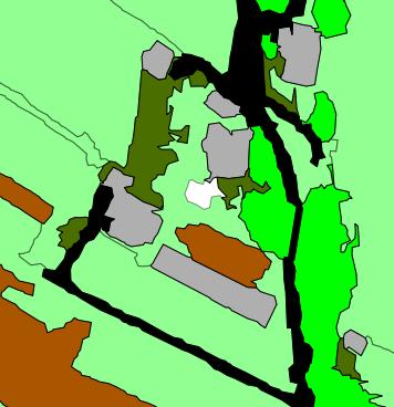
3 Question: what do you see in this image?

4 Question: what do you see in this image (the blue part)?

5 Question: what do you see in this image?
6 Answers Airports Rivers Destroyed buildings You discovered complex objects in an image My claim is: You evaluated spatial properties of simple objects by visual inspection You used your personal semantic knowledge base No much additional information
7 Observation: There must be geometric properties that we (humans) recognize (without metrics). GOAL: Automatic recognition of complex objects in ortophotos by the means of spatial and semantic information
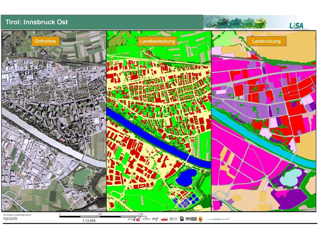
8 Semantic knowledge Hierarchy of subparts airport runway control tower hangar terminal building Hierarchy of subclasses Security check Luggage claim Gates airport big airport small airport single runway shorter than 1,000 m dirt, grass, or gravel runways
9 Semantic knowledge: official sources Corine Land Cover, Urban Atlas LISA (Land Information System of Austria) LCML (Land Cover Meta Language)
10 Observation Official definitions say nothing about the spatial properties and relations among objects This is a gap that should be filled by research
11 Spatial knowledge Based on image resolution, we can identify simple objects that can be part of complex objects Size and shape of runway Size and shape of control tower Spatial relations between runway and terminal building

12 Spatial knowledge If resolution is high we might have better indications!
13 Recognition of complex objects in ortophotos We need to define a methodology to: find the intrinsic definition of a complex object (semantic and spatial) ontological develop an algorithmic strategy to assess the structural properties of a complex object procedural build an appropriate representation for the complex object (visual appearence on a target scale) visual
14 Recognition of complex objects in ortophotos Some use cases Complex objects definition An ontology of spatial relations and operators Evaluation of results Research issues and conclusions
15 LISA (Land Information System of Austria) The LISA is a model of the Austrian environment, representing Land Cover and Land Use objects. The LISA data model 14 classes of Land Cover categories (e.g., buildings, built-up areas, rocks,...); Land Cover is directly derived from EO data; 25 classes of Land Use categories (e.g., settlement, traffic, agriculture, forestry,...); Land Use is derived using additional spatial data, such as: Spatial planning (land use zoning plans) Street maps Agricultural information system Water information system
16
17 LISA use cases Urban settlement (residential)

18 LISA use cases Urban settlement (industrial or commercial)

19 LISA use cases Road

20 LISA use cases Parking

21 LISA use cases Airport

22 LISA use cases Agricultural farmland

23 LISA use cases River basin
24 Recognition of complex objects in ortophotos Some use cases Complex objects definition An ontology of spatial relations and operators Evaluation of results Research issues and conclusions
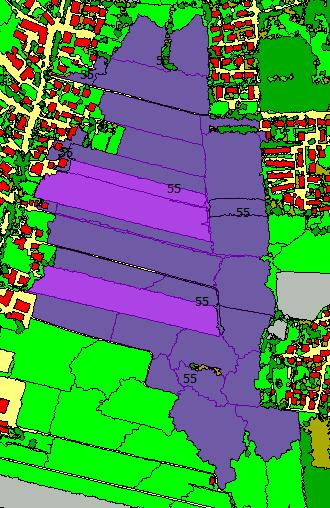
25 Complex objects definition How an urban settlement is defined? From user requirements (cartography experts) we can define a set of rules that identify the object
26 Definition of urban settlement An urban settlement (residential) is defined as: A group of buildings Each building should be smaller than a certain size (otherwise the use of the building would be most likely nonresidential: commercial or industrial use) Small parts of different land cover (high and low vegetation, water, bare soil) connected to the buildings should be part of an urban settlement

27 Definition of urban settlement An urban settlement (residential) is defined as: Narrow segments of roads passing through the group of houses should be aggregated to the complex object, and parkings and culde-sac as well. Main roads should separate the urban settlements Other larger areas (woods, bare soil, and so on) should delimit the complex object as well
28 Complex objects definition Combination of constraints: Thematic constraints Geometric constraints Rules to identify the simple objects that are part of the complex object: e.g., boolean operator to check whether two objects are touching each other Geometric operations to build a representation of the complex object: e.g., a merge operator to combine two simple objects and a split operator to take a piece of a larger object
 2.")
 3.")

29 Procedure to build urban settlements 1. Start from a seed object (a given building) 2. Finding the neighboring objects (of given land cover classes) 3. Repeat the previous step with other neighboring objects 4. Stop when the aggregate is entirely surrounded by other constructed areas (roads, parkings, )
30 Procedure to build urban settlements 5. Repeat previous steps with other buildings not previously considered 6. Group the objects found till now in such a way there exist pairs of neighboring objects that are at a distance less than a given threshold (this means that they are separated by a secondary road) 7. Connect the groups of objects previously identified by some corridors
 9.")
31 Procedure to build urban settlements 8. Filter the result to remove small holes and concavities (internal roads and parkings) 9. From the set of results, eliminate objects that have a size below a given threshold.

32 Test about Urban Settlements (residential areas)
33 Test about Urban Settlements (residential areas) aggregate

34 Test about Urban Settlements (residential areas) group

35 Test about Urban Settlements (residential areas) refine


36 Test about Urban Settlements (residential areas) validate
37 Recognition of complex objects in ortophotos Some use cases Complex objects definition An ontology of spatial relations and operators Evaluation of results Research issues and conclusions
38 Classification of spatial relations Cardinality Granularity Properties of geometric space Object type and dimension Representation level Spatial relations Embedding space dimension
39 Geometric space vs Cardinality of relations Geometric properties of spatial objects (unary relations) Topologic Two disconnected components A hole Projective concave four points of order 0 Metric Four right angles
40 Geometric space vs Cardinality of relations Binary relations Topologic A B A touch B Projective B A A inside concavity of B Metric A bigger than B
41 Geometric space vs Cardinality of relations Ternary relations Topologic B C A overlap Projective C A B A between B and C Metric equidistant
42 Geometric space vs Cardinality of relations N-ary relations Topologic network Projective surrounded by Metric grid
43 Granularity of relations Topological Relations Low granularity Fewer topological invariants are considered overlap Higher granularity More topological invariants are considered overlap + number of disconnected components of intersection
44 Taxonomy of spatial operators GO.01. Property Identification GO.PI.01. Size and Shape (of single object) GO.PI.02. Binary spatial relations GO.PI.03. N-ary spatial relations GO.PI.04. Network analysis GO.PI.05. Validate planar subdivisions GO.02. Geometry Transformation GO.GT.01. Skeleton GO.GT.02. Buffer GO.GT.03. Simplification GO.GT.04. Generalization GO.GT.05. Container GO.GT.06. Network transformation GO.GT.07. Planar subdivision enforcement GO.GT.08. Set operations
 2.")
45 Some implemented operators Operator Is Elongated In Shape boolean iselongatedinshape(geometry inputgeometry, Double tolerance) 1 - Compute the inputgeometry s MBR 2 - Compute the ratio between the perpendicular edges of the MBR (A/B) if ratio >= tolerance return true else return false
 3.")
46 Some implemented operators Operator Same Shape Orientation boolean sameshapeorientation(geometry firstinputgeometry, Geometry secondinputgeometry, Double elongatedtolerance, Double tolerance) 1. Check whether the firstinputgeometry and the secondinputgeometry are elongated in shape 2. Compute the firstinputgeometry s and secondinputgeometry s MBRs (MBR1 and MBR2) 3. Compute the angles α1 and α2 between the longest edges of MBRs and x-axis 4. If difference(α1, α2) <= π/8 ( + tolerance ) OR 7π/8 (- tolerance) <= difference(α1, α2) <= π return true else return false W NW N NE E SW S SE At most π/8 difference corresponds to same orientation
47 Some implemented operators Operator Fusion Geometry fusion(geometry inputgeometry, Double distance, int fusionoption) 1 option 0: neighboring boundaries fusion 2 option 1: convex hull in pairs fusion 3 option 2: convex hull fusion
48 Recognition of complex objects in ortophotos Some use cases Complex objects definition An ontology of spatial relations and operators Evaluation of results Research issues and conclusions

49 Urban settlements (residential)


50 Examples of different fusion and grouping distance parameters Fusion 0 Distance 11 Distance 13 Distance: 30 Fusion 1 Fusion 2

51 Parking lots

52 Urban settlements (industrial or commercial)

53 Agricultural farmland

54 Destroyed buildings

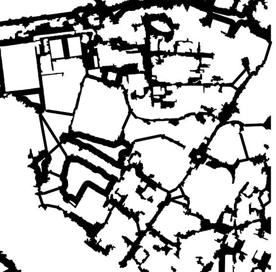
55 Road Network


56 Peculiarities of road networks
57 Classification Classification Accuracy Assessment Error matrix by previous user data Error of commission by Topology System Reference data Single buildings aggregation not aggregated aggregated total User's accuracy not aggregated ,2 aggregated ,3 total Producer's accuracy 81,8 97,1 Error of omission Urban fabric for UA Overal accuracy 87,0 Kappa index 0,731 Reference data not aggregated aggregated total User's accuracy not aggregated , aggregated ,7 total Producer's accuracy 73,7 97,7 Overal accuracy 84,0 Kappa index 0,686
58 Recognition of complex objects in ortophotos Some use cases Complex objects definition An ontology of spatial relations and operators Evaluation of results Research issues and conclusions
59 Classification techniques Pixel-based classification and Segmentationbased classification Multi-temporal rules: based on land cover evolution over time (e.g., soccer field vs corn field) Multispectral images can make finer distinctions (e.g., shadows vs deep water, roofs vs paved roads) GEOBIA (geospatial object based image analysis): to develop methodology for automated or semiautomated classification of geographical elements or complex physical features of Earth land cover
60 State of the art Agencies (e.g., Environmental Protection Agency of Austria) use a combination of automated and manual approaches, based on expert knowledge, to derive land use information from land cover maps. They use ancillary data as well. These methodologies are expensive, time consuming and subjective. In other projects, semi-automatic procedures are applied: e.g, to produce GMES Urban Atlas maps, image analysis packages such as ecognition are used.
61 Proposed approach Automatic recognition of complex objects by combined spatial rules and thematic information. Advantages: once the ontological part (spatial rules) is defined, the process is automatic; the process can be carried out from land cover data without a costly integration with other data sources; direct use of vector data in standard OGC format, which facilitates the integration with other systems; capability of modeling complex objects with a rich internal structure, made of parts and subparts obeying to spatial constraints; the methodology is independent of scale and graphical representation: for instance, the same complex object can have different graphical representations, depending on context and scale.
62 Research Issues How far can we go by checking geometric properties only?
63 Research Issues Definition of a declarative language to express spatial association rules with support and confidence
64 Research issues How to discover the spatial rules that define complex objects? Translating domain experts knowledge Validation of the rule application vs reference data By spatial data mining techniques Automatic extraction of spatial association rules with support and confidence
65 Research Issues Define a modeling tool that is able to represent the ontological part: complex objects, hierarchical structure, spatial association rules.
66 Research Issues Define a high level language for the procedural part From complex objects semantics, it allows us to describe procedures to obtain visual representations at given scale and context.
67 Research Issues Direct application to orthophotos Is it possible to apply directly the methodology to orthophotos without a pre-classification step? It is highly desirable No loss of information due to the pre-classification process Customization of classification process based on needs Approximate spatial relations can be adopted in spatial association rules E.g., building nearly touches road
68 Acknowledgements granted by European Space Agency (ESA), through the Support To Topology (STO) project ( Topology Software System (TSS), developed by SISTEMA GmbH, Vienna, Austria. Environmental Protection Agency of Austria (UBA), Department for Biodiversity and Nature Conservation, Vienna, for providing LISA images GISAT, Praha, Czech Republic, for providing Urban Atlas images
69 Application of Topology to Complex Object Identification Eliseo CLEMENTINI University of L Aquila
A Methodology for the Automatic Generation of Land Use Maps
 456 A Methodology for the Automatic Generation of Land Use Maps Enrico IPPOLITI, Eliseo CLEMENTINI, Stefano NATALI and Gebhard BANKO Abstract Land use maps are usually obtained by a set of semi-automated
OBJECT BASED IMAGE ANALYSIS FOR URBAN MAPPING AND CITY PLANNING IN BELGIUM. P. Lemenkova
 Fig. 3 The fragment of 3D view of Tambov spatial model References 1. Nemtinov,V.A. Information technology in development of spatial-temporal models of the cultural heritage objects: monograph / V.A. Nemtinov,
Key Words: geospatial ontologies, formal concept analysis, semantic integration, multi-scale, multi-context.
 Marinos Kavouras & Margarita Kokla Department of Rural and Surveying Engineering National Technical University of Athens 9, H. Polytechniou Str., 157 80 Zografos Campus, Athens - Greece Tel: 30+1+772-2731/2637,
AN INVESTIGATION OF AUTOMATIC CHANGE DETECTION FOR TOPOGRAPHIC MAP UPDATING
 AN INVESTIGATION OF AUTOMATIC CHANGE DETECTION FOR TOPOGRAPHIC MAP UPDATING Patricia Duncan 1 & Julian Smit 2 1 The Chief Directorate: National Geospatial Information, Department of Rural Development and
DEVELOPMENT OF DIGITAL CARTOGRAPHIC DATABASE FOR MANAGING THE ENVIRONMENT AND NATURAL RESOURCES IN THE REPUBLIC OF SERBIA
 DEVELOPMENT OF DIGITAL CARTOGRAPHIC BASE FOR MANAGING THE ENVIRONMENT AND NATURAL RESOURCES IN THE REPUBLIC OF SERBIA Dragutin Protic, Ivan Nestorov Institute for Geodesy, Faculty of Civil Engineering,
An Automated Object-Oriented Satellite Image Classification Method Integrating the FAO Land Cover Classification System (LCCS).
.") An Automated Object-Oriented Satellite Image Classification Method Integrating the FAO Land Cover Classification System (LCCS). Ruvimbo Gamanya Sibanda Prof. Dr. Philippe De Maeyer Prof. Dr. Morgan De
An Automated Object-Oriented Satellite Image Classification Method Integrating the FAO Land Cover Classification System (LCCS). Ruvimbo Gamanya Sibanda Prof. Dr. Philippe De Maeyer Prof. Dr. Morgan De
Land Cover Classification Mapping & its uses for Planning
 Land Cover Classification Mapping & its uses for Planning What is Land Cover Classification Mapping? Examples of an actual product Why use Land Cover Classification Mapping for planning? Possible uses
Globally Estimating the Population Characteristics of Small Geographic Areas. Tom Fitzwater
 Globally Estimating the Population Characteristics of Small Geographic Areas Tom Fitzwater U.S. Census Bureau Population Division What we know 2 Where do people live? Difficult to measure and quantify.
Validation and verification of land cover data Selected challenges from European and national environmental land monitoring
 Validation and verification of land cover data Selected challenges from European and national environmental land monitoring Gergely Maucha head, Environmental Applications of Remote Sensing Institute of
Generalized map production: Italian experiences
 Generalized map production: Italian experiences FIG Working Week 2012 Knowing to manage the territory, protect the environment, evaluate the cultural heritage Rome, Italy, 6-10 May 2012 Gabriele GARNERO,
Swedish examples on , and
 Swedish examples on 11.2.1, 11.3.1 and 11.7.1 Marie Haldorson, Director Seminar in Nairobi 7 Dec 2018 SDG Indicator Tests by Countries in Europe GEOSTAT 3: ESS Project with a purpose to guide countries
High Resolution Land Use Information by combined Analysis of Digital Landscape Models and Statistical Data Sets. Tobias Krüger Gotthard Meinel
 High Resolution Land Use Information by combined Analysis of Digital Landscape Models and Statistical Data Sets Tobias Krüger Gotthard Meinel Agenda Monitoring approach Input Data Data Processing Output
Analysis of European Topographic Maps for Monitoring Settlement Development
 Analysis of European Topographic Maps for Monitoring Settlement Development Ulrike Schinke*, Hendrik Herold*, Gotthard Meinel*, Nikolas Prechtel** * Leibniz Institute of Ecological Urban and Regional Development,
Innovation. The Push and Pull at ESRI. September Kevin Daugherty Cadastral/Land Records Industry Solutions Manager
 Innovation The Push and Pull at ESRI September 2004 Kevin Daugherty Cadastral/Land Records Industry Solutions Manager The Push and The Pull The Push is the information technology that drives research and
Quality and Coverage of Data Sources
 Quality and Coverage of Data Sources Objectives Selecting an appropriate source for each item of information to be stored in the GIS database is very important for GIS Data Capture. Selection of quality
Cell-based Model For GIS Generalization
 Cell-based Model For GIS Generalization Bo Li, Graeme G. Wilkinson & Souheil Khaddaj School of Computing & Information Systems Kingston University Penrhyn Road, Kingston upon Thames Surrey, KT1 2EE UK
Convex Hull-Based Metric Refinements for Topological Spatial Relations
 ABSTRACT Convex Hull-Based Metric Refinements for Topological Spatial Relations Fuyu (Frank) Xu School of Computing and Information Science University of Maine Orono, ME 04469-5711, USA fuyu.xu@maine.edu
Measuring and Monitoring SDGs in Portugal: Ratio of land consumption rate to population growth rate Mountain Green Cover Index
 Measuring and Monitoring SDGs in Portugal: 11.3.1Ratio of land consumption rate to population growth rate 15.4.2 Mountain Green Cover Index United Nations World Geospatial Information Congress João David
Exploring Spatial Relationships for Knowledge Discovery in Spatial Data
 2009 International Conference on Computer Engineering and Applications IPCSIT vol.2 (2011) (2011) IACSIT Press, Singapore Exploring Spatial Relationships for Knowledge Discovery in Spatial Norazwin Buang
Compact guides GISCO. Geographic information system of the Commission
 Compact guides GISCO Geographic information system of the Commission What is GISCO? GISCO, the Geographic Information System of the COmmission, is a permanent service of Eurostat that fulfils the requirements
Urban land cover and land use extraction from Very High Resolution remote sensing imagery
 Urban land cover and land use extraction from Very High Resolution remote sensing imagery Mengmeng Li* 1, Alfred Stein 1, Wietske Bijker 1, Kirsten M.de Beurs 2 1 Faculty of Geo-Information Science and
THE OVERALL EAGLE CONCEPT
 Sentinel Hub THE OVERALL EAGLE CONCEPT GEBHARD BANKO, 30. MAY 2018, COPENHAGEN ISO TC 211, STANDARDS IN ACTION SEMINAR CONTENT Background and Motivation Criteria and Structure of Data Model Semantic decomposition
Airborne Multi-Spectral Minefield Survey
 Dirk-Jan de Lange, Eric den Breejen TNO Defence, Security and Safety Oude Waalsdorperweg 63 PO BOX 96864 2509 JG The Hague THE NETHERLANDS Phone +31 70 3740857 delange@fel.tno.nl ABSTRACT The availability
Urban settlements delimitation using a gridded spatial support
 Urban settlements delimitation using a gridded spatial support Rita Nicolau 1, Elisa Vilares 1, Cristina Cavaco 1, Ana Santos 2, Mário Lucas 2 1 - General Directorate for Territory Development DGT, Portugal
Copernicus Land HRL Imperviousness: 2012 dataset, indicator Title
 Copernicus Land HRL Imperviousness: 2012 dataset, 06-09 indicator and outlook Title 2015+ Tobias LANGANKE First name SURNAME Project manager, Copernicus Position land services Name European of the Environment
EO Information Services. Assessing Vulnerability in the metropolitan area of Rio de Janeiro (Floods & Landslides) Project
 Project") EO Information Services in support of Assessing Vulnerability in the metropolitan area of Rio de Janeiro (Floods & Landslides) Project Ricardo Armas, Critical Software SA Haris Kontoes, ISARS NOA World
EO Information Services in support of Assessing Vulnerability in the metropolitan area of Rio de Janeiro (Floods & Landslides) Project Ricardo Armas, Critical Software SA Haris Kontoes, ISARS NOA World
Basics of GIS. by Basudeb Bhatta. Computer Aided Design Centre Department of Computer Science and Engineering Jadavpur University
 Basics of GIS by Basudeb Bhatta Computer Aided Design Centre Department of Computer Science and Engineering Jadavpur University e-governance Training Programme Conducted by National Institute of Electronics
Global Land Cover Mapping
 Global Land Cover Mapping and its application in SDGs Prof. Chen Jun 1, Dr. He Chaoying 2 1 National Geomatics Center of China (NGCC) 2 Ministry of Natural Resources, P.R.China May 30, 2018, Copenhagen
Overview key concepts and terms (based on the textbook Chang 2006 and the practical manual)
") Introduction Geo-information Science (GRS-10306) Overview key concepts and terms (based on the textbook 2006 and the practical manual) Introduction Chapter 1 Geographic information system (GIS) Geographically
Introduction Geo-information Science (GRS-10306) Overview key concepts and terms (based on the textbook 2006 and the practical manual) Introduction Chapter 1 Geographic information system (GIS) Geographically
Experiences and Directions in National Portals"
 FIG Seminar on e-land Administration Innsbruck/Austria 2-4 June 2004 "ESRI's Experiences and Directions in National Portals" Kevin Daugherty Cadastral/Land Records Manager ESRI Topic Points Technology
Training on national land cover classification systems. Toward the integration of forest and other land use mapping activities.
 Training on national land cover classification systems Toward the integration of forest and other land use mapping activities. Guiana Shield 9 to 13 March 2015, Paramaribo, Suriname Background Sustainable
AUTOMATIC EXTRACTION OF ALUVIAL FANS FROM ASTER L1 SATELLITE DATA AND A DIGITAL ELEVATION MODEL USING OBJECT-ORIENTED IMAGE ANALYSIS
 AUTOMATIC EXTRACTION OF ALUVIAL FANS FROM ASTER L1 SATELLITE DATA AND A DIGITAL ELEVATION MODEL USING OBJECT-ORIENTED IMAGE ANALYSIS Demetre P. Argialas, Angelos Tzotsos Laboratory of Remote Sensing, Department
An Update on Land Use & Land Cover Mapping in Ireland
 An Update on Land Use & Land Cover Mapping in Ireland Progress Towards a National Programme Kevin Lydon k.lydon@epa.ie Office of Environmental Assessment, Environmental Protection Agency, Johnstown Castle,
DEVELOPMENT OF AN ADVANCED UNCERTAINTY MEASURE FOR CLASSIFIED REMOTELY SENSED SCENES
 DEVELOPMENT OF AN ADVANCED UNCERTAINTY MEASURE FOR CLASSIFIED REMOTELY SENSED SCENES J. Schiewe, C. Kinkeldey HafenCity University Hamburg, Lab for Geoinformatics and Geovisualization (g²lab) Hebebrandstr.
Pixel-based and object-based landslide mapping: a methodological comparison
 Pixel-based and object-based landslide mapping: a methodological comparison Daniel HÖLBLING 1, Tsai-Tsung TSAI 2, Clemens EISANK 1, Barbara FRIEDL 1, Chjeng-Lun SHIEH 2, and Thomas BLASCHKE 1 1 Department
3D City/Landscape Modeling Non-Building Thematic: Vegetation
 3D City/Landscape Modeling Non-Building Thematic: Vegetation Presenter: Shafarina Wahyu Trisyanti shafarina.wahyu@gmail.com Co-Author: Deni Suwardhi, Agung Budi Harto dsuwardhi@kk-insig.org, agung@gd.itb.ac.id
Comparing CORINE Land Cover with a more detailed database in Arezzo (Italy).
.") Comparing CORINE Land Cover with a more detailed database in Arezzo (Italy). Javier Gallego JRC, I-21020 Ispra (Varese) ITALY e-mail: javier.gallego@jrc.it Keywords: land cover, accuracy assessment, area
Comparing CORINE Land Cover with a more detailed database in Arezzo (Italy). Javier Gallego JRC, I-21020 Ispra (Varese) ITALY e-mail: javier.gallego@jrc.it Keywords: land cover, accuracy assessment, area
Taxonomies of Building Objects towards Topographic and Thematic Geo-Ontologies
 Taxonomies of Building Objects towards Topographic and Thematic Geo-Ontologies Melih Basaraner Division of Cartography, Department of Geomatic Engineering, Yildiz Technical University (YTU), Istanbul Turkey
Abstract: Contents. Literature review. 2 Methodology.. 2 Applications, results and discussion.. 2 Conclusions 12. Introduction
 Abstract: Landfill is one of the primary methods for municipal solid waste disposal. In order to reduce the environmental damage and to protect the public health and welfare, choosing the site for landfill
1st EARSeL Workshop of the SIG Urban Remote Sensing Humboldt-Universität zu Berlin, 2-3 March 2006
 1 AN URBAN CLASSIFICATION APPROACH BASED ON AN OBJECT ORIENTED ANALYSIS OF HIGH RESOLUTION SATELLITE IMAGERY FOR A SPATIAL STRUCTURING WITHIN URBAN AREAS Hannes Taubenböck, Thomas Esch, Achim Roth German
MANUAL ON THE BSES: LAND USE/LAND COVER
 6. Environment Protection, Management and Engagement 2. Environmental Resources and their Use 5. Human Habitat and Environmental Health 1. Environmental Conditions and Quality 4. Disasters and Extreme
CS 350 A Computing Perspective on GIS
 CS 350 A Computing Perspective on GIS What is GIS? Definitions A powerful set of tools for collecting, storing, retrieving at will, transforming and displaying spatial data from the real world (Burrough,
Chapter 6. Fundamentals of GIS-Based Data Analysis for Decision Support. Table 6.1. Spatial Data Transformations by Geospatial Data Types
 Chapter 6 Fundamentals of GIS-Based Data Analysis for Decision Support FROM: Points Lines Polygons Fields Table 6.1. Spatial Data Transformations by Geospatial Data Types TO: Points Lines Polygons Fields
Module 3 Indicator Land Consumption Rate to Population Growth Rate
 Regional Training Workshop on Human Settlement Indicators Module 3 Indicator 11.3.1 Land Consumption Rate to Population Growth Rate Dennis Mwaniki Global Urban Observatory, Research and Capacity Development
Object Oriented Classification Using High-Resolution Satellite Images for HNV Farmland Identification. Shafique Matin and Stuart Green
 Object Oriented Classification Using High-Resolution Satellite Images for HNV Farmland Identification Shafique Matin and Stuart Green REDP, Teagasc Ashtown, Dublin, Ireland Correspondence: shafique.matin@teagasc.ie
FUNDAMENTALS OF GEOINFORMATICS PART-II (CLASS: FYBSc SEM- II)
") FUNDAMENTALS OF GEOINFORMATICS PART-II (CLASS: FYBSc SEM- II) UNIT:-I: INTRODUCTION TO GIS 1.1.Definition, Potential of GIS, Concept of Space and Time 1.2.Components of GIS, Evolution/Origin and Objectives
FUNDAMENTALS OF GEOINFORMATICS PART-II (CLASS: FYBSc SEM- II) UNIT:-I: INTRODUCTION TO GIS 1.1.Definition, Potential of GIS, Concept of Space and Time 1.2.Components of GIS, Evolution/Origin and Objectives
Towards indicators of proximity to services in Europe's major cities
 Towards indicators of proximity to services in Europe's major cities Enhancing the analytical use of the GMES Urban Atlas in combination with population distribution data Hugo Poelman European Commission
PRINCIPLES OF PHOTO INTERPRETATION
 PRINCIPLES OF PHOTO INTERPRETATION Photo Interpretation the act of examining photographic images for the purpose of identifying objects and judging their significance an art more than a science Recognition
Exploring representational issues in the visualisation of geographical phenomenon over large changes in scale.
 Institute of Geography Online Paper Series: GEO-017 Exploring representational issues in the visualisation of geographical phenomenon over large changes in scale. William Mackaness & Omair Chaudhry Institute
Pilot studies on the provision of harmonized land use/land cover statistics: Synergies between LUCAS and the national systems
 1 Pilot studies on the provision of harmonized land use/land cover statistics: Synergies between LUCAS and the national systems Norway Erik Engelien Division for Natural resources and Environmental Statistics,
UK Contribution to the European CORINE Land Cover
 Centre for Landscape andwww.le.ac.uk/clcr Climate Research CENTRE FOR Landscape and Climate Research UK Contribution to the European CORINE Land Cover Dr Beth Cole Corine Coordination of Information on
LAND COVER CATEGORY DEFINITION BY IMAGE INVARIANTS FOR AUTOMATED CLASSIFICATION
 LAND COVER CATEGORY DEFINITION BY IMAGE INVARIANTS FOR AUTOMATED CLASSIFICATION Nguyen Dinh Duong Environmental Remote Sensing Laboratory Institute of Geography Hoang Quoc Viet Rd., Cau Giay, Hanoi, Vietnam
SPATIAL DATA MINING. Ms. S. Malathi, Lecturer in Computer Applications, KGiSL - IIM
 SPATIAL DATA MINING Ms. S. Malathi, Lecturer in Computer Applications, KGiSL - IIM INTRODUCTION The main difference between data mining in relational DBS and in spatial DBS is that attributes of the neighbors
INVESTIGATING GEOSPARQL REQUIREMENTS FOR PARTICIPATORY URBAN PLANNING
 INVESTIGATING GEOSPARQL REQUIREMENTS FOR PARTICIPATORY URBAN PLANNING E. Mohammadi a, *, A. J.S. Hunter a a Geomatics Department, Schulich School of Engineering, University of Calgary, Calgary, T2N 1N4,
Spanish national plan for land observation: new collaborative production system in Europe
 ADVANCE UNEDITED VERSION UNITED NATIONS E/CONF.103/5/Add.1 Economic and Social Affairs 9 July 2013 Tenth United Nations Regional Cartographic Conference for the Americas New York, 19-23, August 2013 Item
Urban remote sensing: from local to global and back
 Urban remote sensing: from local to global and back Paolo Gamba University of Pavia, Italy A few words about Pavia Historical University (1361) in a nice town slide 3 Geoscience and Remote Sensing Society
LAND USE, LAND COVER AND SOIL SCIENCES - Vol. I - Land Use and Land Cover, Including their Classification - Duhamel C.
 LAND USE AND LAND COVER, INCLUDING THEIR CLASSIFICATION Duhamel Landsis Groupement Européen d Intérêt Economique, Luxembourg Keywords: land cover, land use, classification systems, nomenclature, information
Spatial analysis in XML/GML/SVG based WebGIS
 Spatial analysis in XML/GML/SVG based WebGIS Haosheng Huang, Yan Li huang@cartography.tuwien.ac.at and yanli@scnu.edu.cn Research Group Cartography, Vienna University of Technology Spatial Information
![)UDQFR54XHQWLQ(DQG'tD]'HOJDGR&](/thumbs/95/125846872.jpg ")UDQFR54XHQWLQ(DQG'tD]'HOJDGR&") &21&(37,21$1',03/(0(17$7,212)$1+
&21&(37,21$1',03/(0(17$7,212)$1+ Trimble s ecognition Product Suite
 Trimble s ecognition Product Suite Dr. Waldemar Krebs October 2010 Trimble Geospatial in the Image Processing Chain Data Acquisition Pre-processing Manual/Pixel-based Object-/contextbased Interpretation
EAGLE Data Model and Outcomes of HELM (Harmonised European Land Monitoring)
") EAGLE Data Model and Outcomes of HELM (Harmonised European Land Monitoring) Contribution towards better land information harmonisation and INSPIRE compliance EAGLE working group Stephan Arnold, Barbara
EAGLE Data Model and Outcomes of HELM (Harmonised European Land Monitoring) Contribution towards better land information harmonisation and INSPIRE compliance EAGLE working group Stephan Arnold, Barbara
A STRATEGY FOR QUALITY ASSURANCE OF LAND-COVER/LAND-USE INTERPRETATION RESULTS WITH FAULTY OR OBSOLETE REFERENCE DATA
 A STRATEGY FOR QUALITY ASSURANCE OF LAND-COVER/LAND-USE INTERPRETATION RESULTS WITH FAULTY OR OBSOLETE REFERENCE DATA P.Hofmann, P. Lohmann Leibniz University of Hannover, Institute for Photogrammetry
REMOTE SENSING AND GEOSPATIAL APPLICATIONS FOR WATERSHED DELINEATION
 REMOTE SENSING AND GEOSPATIAL APPLICATIONS FOR WATERSHED DELINEATION Gaurav Savant (gaurav@engr.msstate.edu) Research Assistant, Department of Civil Engineering, Lei Wang (lw4@ra.msstate.edu) Research
APPLYING THE END FOR LOMBARDY S AIRPORTS
 APPLYING THE END FOR LOMBARDY S AIRPORTS Angela Alberici, Maurizio Bassanino, Paolo Deforza, Nadia Fibbiani, Paola Maggi, Mauro Mussin, Valeria Spirolazzi ARPA Lombardia Via Francesco Restelli 3\1, 20124,
Flood Hazard Zone Modeling for Regulation Development
 Flood Hazard Zone Modeling for Regulation Development By Greg Lang and Jared Erickson Pierce County GIS June 2003 Abstract The desire to blend current digital information with government permitting procedures,
INSPIRE Land Cover and Land Use Data Specifications
 INSPIRE Land Cover and Land Use Data Specifications Lena Hallin-Pihlatie Facilitator of the Land Cover and Land Use INSPIRE Thematic Cluster www.jrc.ec.europa.eu Serving society Stimulating innovation
A Method for Mapping Settlement Area Boundaries in the Greater Golden Horseshoe
 A Method for Mapping Settlement Area Boundaries in the Greater Golden Horseshoe Purpose This paper describes a method for mapping and measuring the lands designated for growth and urban expansion in the
C o p e r n i c u s L a n d M o n i t o r i n g S e r v i c e
 C o p e r n i c u s L a n d M o n i t o r i n g S e r v i c e Submodule D: stability of protected areas & related pressures: Natura2000 sites Copernicus EU Copernicus EU Copernicus EU www.copernicus.eu
URBAN LAND COVER AND LAND USE CLASSIFICATION USING HIGH SPATIAL RESOLUTION IMAGES AND SPATIAL METRICS
 URBAN LAND COVER AND LAND USE CLASSIFICATION USING HIGH SPATIAL RESOLUTION IMAGES AND SPATIAL METRICS Ivan Lizarazo Universidad Distrital, Department of Cadastral Engineering, Bogota, Colombia; ilizarazo@udistrital.edu.co
4CitySemantics. GIS-Semantic Tool for Urban Intervention Areas
 4CitySemantics GIS-Semantic Tool for Urban Intervention Areas Nuno MONTENEGRO 1 ; Jorge GOMES 2 ; Paulo URBANO 2 José P. DUARTE 1 1 Faculdade de Arquitectura da Universidade Técnica de Lisboa, Rua Sá Nogueira,
Innovation in mapping and photogrammetry at the Survey of Israel
 16, October, 2017 Innovation in mapping and photogrammetry at the Survey of Israel Yaron Felus and Ronen Regev Contents Why HD mapping? Government requirements Mapping regulations o Quality requirements
Louisiana Transportation Engineering Conference. Monday, February 12, 2007
 Louisiana Transportation Engineering Conference Monday, February 12, 2007 Agenda Project Background Goal of EIS Why Use GIS? What is GIS? How used on this Project Other site selection tools I-69 Corridor
Mapping and Assessment of Ecosystems and their Services
 Mapping and Assessment of Ecosystems and their Services ALTER-Net Conference 2013: Science underpinning the EU 2020 Biodiversity Strategy. April 2013 Gent Joachim MAES 1 This presentation is based on the
A General Framework for Conflation
 A General Framework for Conflation Benjamin Adams, Linna Li, Martin Raubal, Michael F. Goodchild University of California, Santa Barbara, CA, USA Email: badams@cs.ucsb.edu, linna@geog.ucsb.edu, raubal@geog.ucsb.edu,
GIS = Geographic Information Systems;
 What is GIS GIS = Geographic Information Systems; What Information are we talking about? Information about anything that has a place (e.g. locations of features, address of people) on Earth s surface,
EO4SEE - THE PATHFINDER OF OPERATIONAL SATELLITE MONITORING FOR THE REGION OF THE BLACK SEA AND CENTRAL EUROPE
 EO4SEE: Pathfinder assessment for regional high volume data access, processing and information service delivery platforms - South East Region EO4SEE - THE PATHFINDER OF OPERATIONAL SATELLITE MONITORING
CityGML XFM Application Template Documentation. Bentley Map V8i (SELECTseries 2)
") CityGML XFM Application Template Documentation Bentley Map V8i (SELECTseries 2) Table of Contents Introduction to CityGML 1 CityGML XFM Application Template 2 Requirements 2 Finding Documentation 2 To
CityGML XFM Application Template Documentation Bentley Map V8i (SELECTseries 2) Table of Contents Introduction to CityGML 1 CityGML XFM Application Template 2 Requirements 2 Finding Documentation 2 To
Harmonizing Level of Detail in OpenStreetMap Based Maps
 Harmonizing Level of Detail in OpenStreetMap Based Maps G. Touya 1, M. Baley 1 1 COGIT IGN France, 73 avenue de Paris 94165 Saint-Mandé France Email: guillaume.touya{at}ign.fr 1. Introduction As OpenStreetMap
Development of a Cartographic Expert System
 Development of a Cartographic Expert System Research Team Lysandros Tsoulos, Associate Professor, NTUA Constantinos Stefanakis, Dipl. Eng, M.App.Sci., PhD 1. Introduction Cartographic design and production
Summary Description Municipality of Anchorage. Anchorage Coastal Resource Atlas Project
 Summary Description Municipality of Anchorage Anchorage Coastal Resource Atlas Project By: Thede Tobish, MOA Planner; and Charlie Barnwell, MOA GIS Manager Introduction Local governments often struggle
Applied Cartography and Introduction to GIS GEOG 2017 EL. Lecture-1 Chapters 1 and 2
 Applied Cartography and Introduction to GIS GEOG 2017 EL Lecture-1 Chapters 1 and 2 What is GIS? A Geographic Information System (GIS) is a computer system for capturing, storing, querying, analyzing and
Efficient and Robust Graphics Recognition from Historical Maps
 Efficient and Robust Graphics Recognition from Historical Maps Yao-Yi Chiang, 1 Stefan Leyk, 2 and Craig A. Knoblock 3 1 Information Sciences Institute and Spatial Sciences Institute, University of Southern
Geography 38/42:376 GIS II. Topic 1: Spatial Data Representation and an Introduction to Geodatabases. The Nature of Geographic Data
 Geography 38/42:376 GIS II Topic 1: Spatial Data Representation and an Introduction to Geodatabases Chapters 3 & 4: Chang (Chapter 4: DeMers) The Nature of Geographic Data Features or phenomena occur as
FINDING SPATIAL UNITS FOR LAND USE CLASSIFICATION BASED ON HIERARCHICAL IMAGE OBJECTS
 ISPRS SIPT IGU UCI CIG ACSG Table of contents Table des matières Authors index Index des auteurs Search Recherches Exit Sortir FINDING SPATIAL UNITS FOR LAND USE CLASSIFICATION BASED ON HIERARCHICAL IMAGE
IMPROVING REMOTE SENSING-DERIVED LAND USE/LAND COVER CLASSIFICATION WITH THE AID OF SPATIAL INFORMATION
 IMPROVING REMOTE SENSING-DERIVED LAND USE/LAND COVER CLASSIFICATION WITH THE AID OF SPATIAL INFORMATION Yingchun Zhou1, Sunil Narumalani1, Dennis E. Jelinski2 Department of Geography, University of Nebraska,
Supplementary material: Methodological annex
 1 Supplementary material: Methodological annex Correcting the spatial representation bias: the grid sample approach Our land-use time series used non-ideal data sources, which differed in spatial and thematic
KNOWLEDGE-BASED CLASSIFICATION OF LAND COVER FOR THE QUALITY ASSESSEMENT OF GIS DATABASE. Israel -
 KNOWLEDGE-BASED CLASSIFICATION OF LAND COVER FOR THE QUALITY ASSESSEMENT OF GIS DATABASE Ammatzia Peled a,*, Michael Gilichinsky b a University of Haifa, Department of Geography and Environmental Studies,
Object Based Land Cover Extraction Using Open Source Software
 Object Based Land Cover Extraction Using Open Source Software Abhasha Joshi 1, Janak Raj Joshi 2, Nawaraj Shrestha 3, Saroj Sreshtha 4, Sudarshan Gautam 5 1 Instructor, Land Management Training Center,
New approach for land use mapping in the Netherlands (LGN6)
") New approach for land use mapping in the Netherlands (LGN6) Gerard Hazeu & Rini Schuiling Content Objectives Background LGN and its history National and European activities (e.g. INSPIRE) Methodology LGN6
New approach for land use mapping in the Netherlands (LGN6) Gerard Hazeu & Rini Schuiling Content Objectives Background LGN and its history National and European activities (e.g. INSPIRE) Methodology LGN6
AUTOMATIC DIGITIZATION OF CONVENTIONAL MAPS AND CARTOGRAPHIC PATTERN RECOGNITION
 Abstract: AUTOMATC DGTZATON OF CONVENTONAL MAPS AND CARTOGRAPHC PATTERN RECOGNTON Werner Lichtner nstitute of Cartography (fk) University of Hannover FRG Commission V One important task of the establishment
GIS Generalization Dr. Zakaria Yehia Ahmed GIS Consultant Ain Shams University Tel: Mobile:
 GIS Generalization Dr. Zakaria Yehia Ahmed GIS Consultant Ain Shams University Tel: 24534976 Mobile: 01223384254 zyehia2005@yahoo.com Abstract GIS Generalization makes data less-detailed and less-complex
Land Use Planning and Agriculture: Austrian Experiences and Challenges I
 Land Use Planning and Agriculture: Austrian Experiences and Challenges I SULANET Summer School 2016 Walter Seher BOKU Vienna 1 Land Use Planning and Agriculture 2 Land Use Planning and Agriculture Agriculture
The LISA extension to INSPIRE LC/LU data model: The Austrian experience
 The LISA extension to INSPIRE LC/LU data model: The Austrian experience Gebhard Banko, Environment Agency Austria Roland Grillmayer, Environment Agency Austria Wolfgang Stemberger, GeoVille INSPIRE KEN
The Road to Data in Baltimore
 Creating a parcel level database from high resolution imagery By Austin Troy and Weiqi Zhou University of Vermont, Rubenstein School of Natural Resources State and local planning agencies are increasingly
Designing GIS Databases to Support Mapping and Map Production Charlie Frye, ESRI Redlands Aileen Buckley, ESRI Redlands
 Designing GIS Databases to Support Mapping and Map Production Charlie Frye, ESRI Redlands Aileen Buckley, ESRI Redlands 1 Designing GIS Databases to Support Mapping and Map Production Charlie Frye, ESRI
Lecture 9: Reference Maps & Aerial Photography
 Lecture 9: Reference Maps & Aerial Photography I. Overview of Reference and Topographic Maps There are two basic types of maps? Reference Maps - General purpose maps & Thematic Maps - maps made for a specific
A Case Study for Semantic Translation of the Water Framework Directive and a Topographic Database
 A Case Study for Semantic Translation of the Water Framework Directive and a Topographic Database Angela Schwering * + Glen Hart + + Ordnance Survey of Great Britain Southampton, U.K. * Institute for Geoinformatics,
Contents Introduction... 3 Get the data... 4 Workflow... 7 Test 1: Urban fabric (all)... 8 Test 2: Urban fabric (industrial and commercial)...
... 8 Test 2: Urban fabric (industrial and commercial)...") AAXY tutorial Contents Introduction... 3 Get the data... 4 Workflow... 7 Test 1: Urban fabric (all)... 8 Test 2: Urban fabric (industrial and commercial)... 9 Test 3: Urban fabric (residential)... 10 Test
AAXY tutorial Contents Introduction... 3 Get the data... 4 Workflow... 7 Test 1: Urban fabric (all)... 8 Test 2: Urban fabric (industrial and commercial)... 9 Test 3: Urban fabric (residential)... 10 Test
Traffic accidents and the road network in SAS/GIS
 Traffic accidents and the road network in SAS/GIS Frank Poppe SWOV Institute for Road Safety Research, the Netherlands Introduction The first figure shows a screen snapshot of SAS/GIS with part of the
HIERARCHICAL IMAGE OBJECT-BASED STRUCTURAL ANALYSIS TOWARD URBAN LAND USE CLASSIFICATION USING HIGH-RESOLUTION IMAGERY AND AIRBORNE LIDAR DATA
 HIERARCHICAL IMAGE OBJECT-BASED STRUCTURAL ANALYSIS TOWARD URBAN LAND USE CLASSIFICATION USING HIGH-RESOLUTION IMAGERY AND AIRBORNE LIDAR DATA Qingming ZHAN, Martien MOLENAAR & Klaus TEMPFLI International