PRINCIPLES OF PHOTO INTERPRETATION
|
|
|
- Susan Oliver
- 6 years ago
- Views:
Transcription
1 PRINCIPLES OF PHOTO INTERPRETATION Photo Interpretation the act of examining photographic images for the purpose of identifying objects and judging their significance an art more than a science Recognition Elements seven Principles of Photo Interpretation tools used by photo interpreters skilled interpreter makes inferences based on the synthesis of a few or several Principles of P.I.
2 Photo interpretation requires some training and experience with conditions on the ground to be most effective. The accuracy of the mapping results can be quite variable depending on the skill level of the interpreter. The photo interpreter uses several recognition factors and most importantly, human reasoning to pull all of the clues together when making interpretation decisions
3 PRINCIPLES OF PHOTO INTERPRETATION SIZE SHAPE SHADOW TEXTURE PATTERN ASSOCIATION/SITE TONE (OR COLOR) These are the seven PI recognition elements or principles. A trained interpreter uses PI principles intuitively and combines them into a reasoning process that concludes in the object identification or the delineation of stand type boundaries. In some cases, one or two of the recognition elements will be more heavily relied on in the interpretation decision, depending on the photography and the environment under study.


4 PI Recognition Features SIZE SHAPE SHADOW TEXTURE PATTERN ASSOCIATION TONE (OR COLOR)
 with 250 ft.")
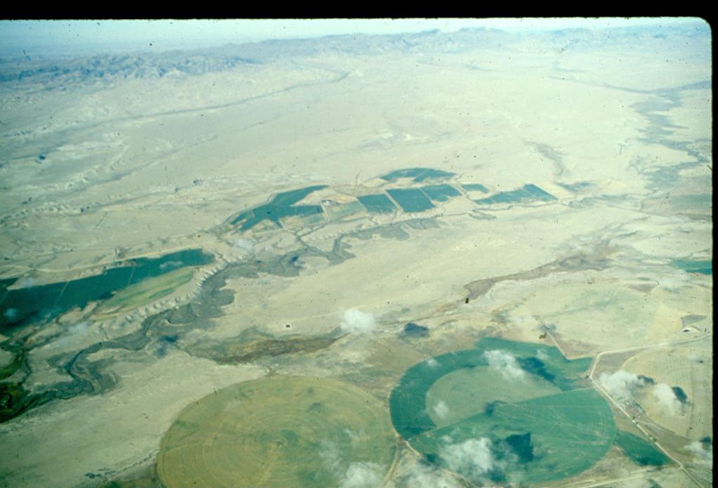
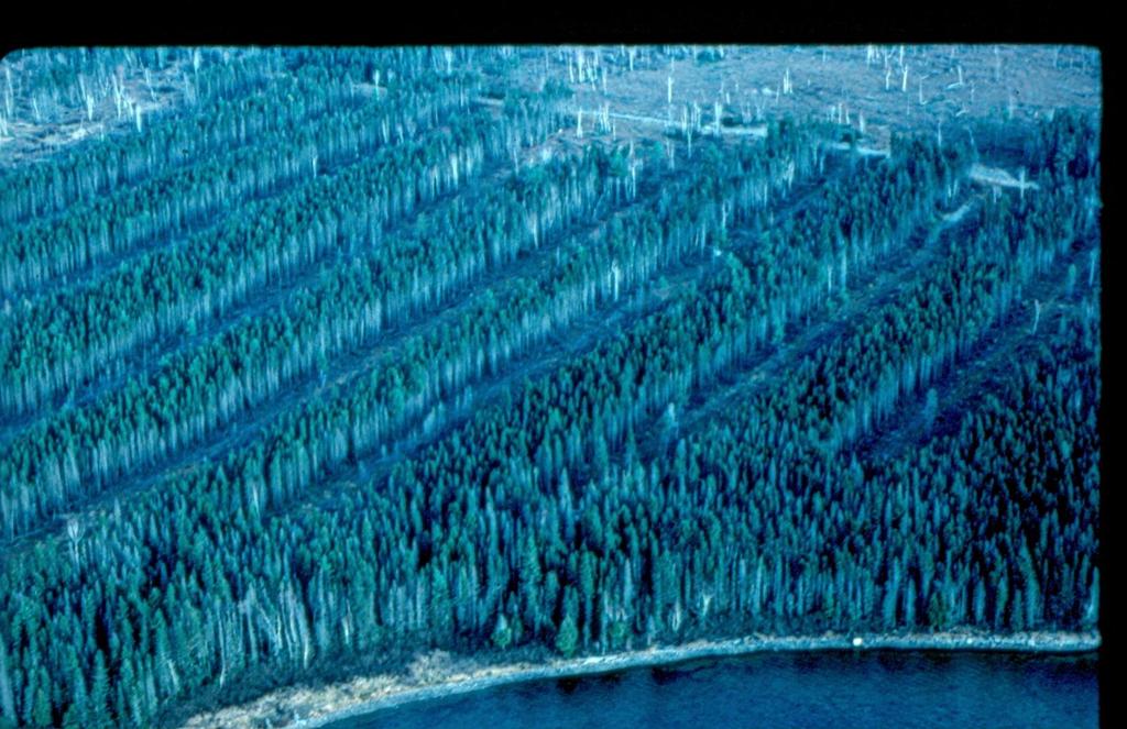
5 SIZE & SHAPE Maine Forest Practices Act Category 1 clearcuts (<35 acres in 1991) with 250 ft. forest separation zone

6 Unharvested Category 1 Clearcut - Separation Zone Harvest in Cat.1 FPA Separation Zone by 2004 Sader et al. 2005, J. Forestry


7 PRINCIPLES OF PHOTO INTERPRETATION SIZE SHAPE SHADOW TEXTURE PATTERN ASSOCIATION TONE (OR COLOR)
8
9
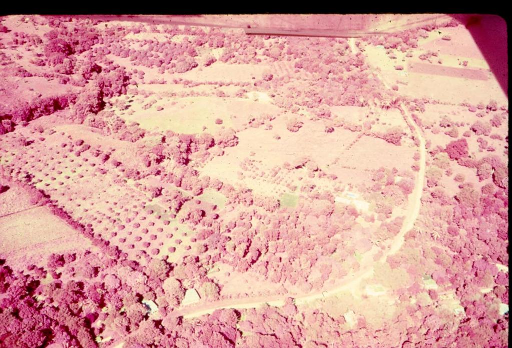
10 SHAPE AND ASSOCIATION Bog and Hay Field

11 PRINCIPLES OF PHOTO INTERPRETATION SIZE SHAPE SHADOW TEXTURE PATTERN ASSOCIATION TONE (OR COLOR)

12 SHADOWS Spruce Trees- Pyramidal or tapered shape of shadow in fields - UM Campus at Park St. and Rangley Road

13 PRINCIPLES OF PHOTO INTERPRETATION SIZE SHAPE SHADOW TEXTURE PATTERN ASSOCIATION TONE (OR COLOR)

14 TEXTURE Mixed Forest mottled Older natural forest coarser texture Softwood Plantation, even-aged - smooth

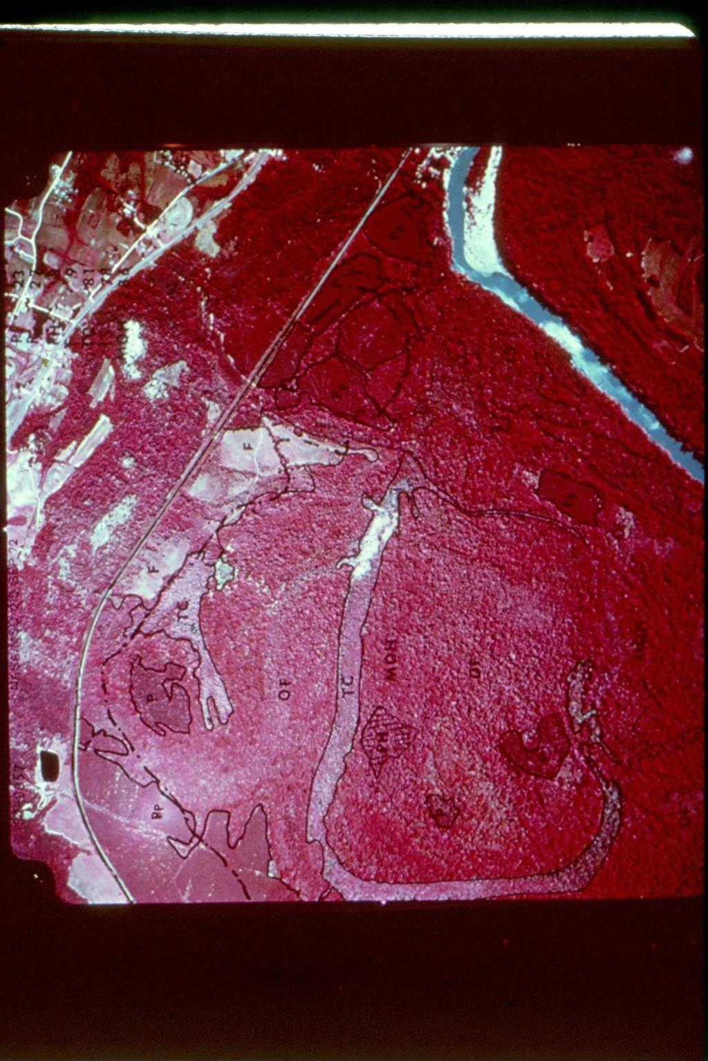
 River meander scars and")
15 PRINCIPLES OF PHOTO INTERPRETATION SIZE SHAPE SHADOW TEXTURE PATTERN ASSOCIATION Spaghetti roads of a heavy harvest TONE (OR COLOR) River meander scars and oxbows


16 USGS DOQs - So. ME 1998 New subdivision 2003 New clearing here
17

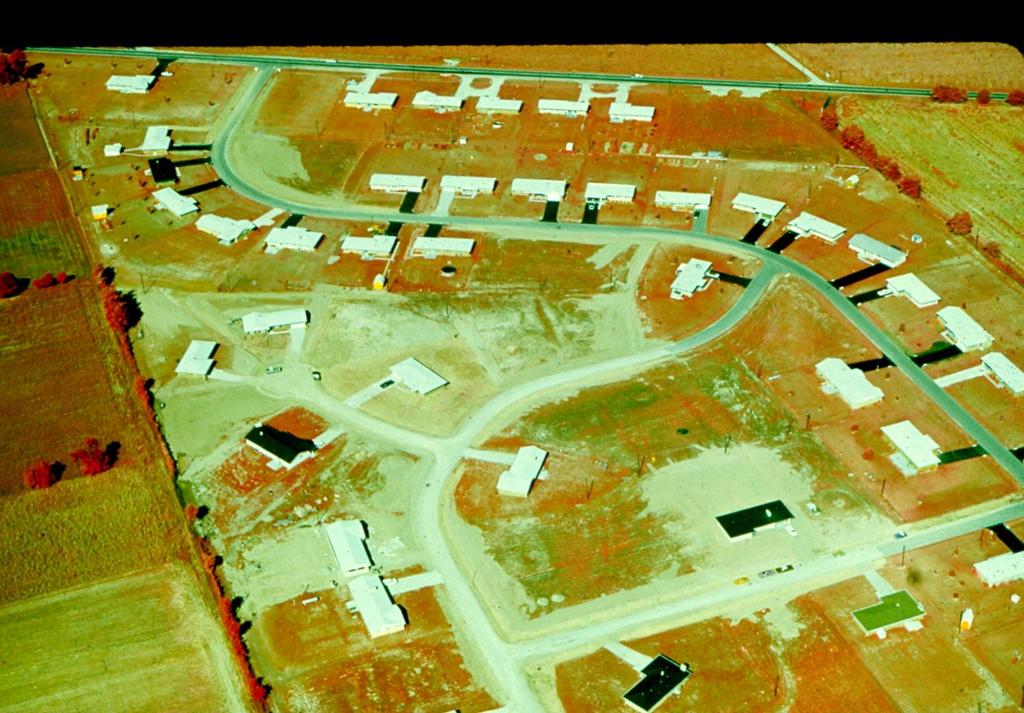
18 PATTERN Hay Fields Angular Trailer Park regular spacing and orientation Roads linear or curvi-linear

19 PRINCIPLES OF PHOTO INTERPRETATION SIZE SHAPE SHADOW TEXTURE PATTERN ASSOCIATION TONE (OR COLOR)

20 PRINCIPLES OF PHOTO INTERPRETATION SIZE SHAPE SHADOW TEXTURE PATTERN ASSOCIATION/SITE TONE (OR COLOR)

21 Association- What relationship do the circular objects in the center have with the facility on the right center??

22 SHAPE AND ASSOCIATION Bog and Hay Field


23 Association/Site Conditions Topographic or soil-site relationships Black Spruce and tamarack (larch) in bogs Red maple swamps Hardwoods on upper slopes, spruce-fir in the valleys
24 PRINCIPLES OF PHOTO INTERPRETATION SIZE SHAPE SHADOW TEXTURE PATTERN ASSOCIATION TONE (OR COLOR) tone / color differences make all other recognition elements possible Learn to interpret objects on different film types understanding albedo / spectral signatures of objects


25 BW Panchromatic tone variation Color Infrared color variation
26
27
28
29
30

31 LAND COVER AND LAND USE Land Cover type of feature physically present on the surface e.g. crops, forest, roads, urban features, etc. Land Use refers to the human employment of the land and its features e.g. residential, commercial, industrial, agriculture (crop, fallow, pasture), forest management, park / preserve, etc.

32 LAND COVER AND LAND USE example: land use: single-family residential land cover: roofs pavement grass trees
33 LAND COVER AND LAND USE * definitions of land cover and land use categories depends on a particular application, scale of analysis the classification scheme example: land use: single-family residential land cover: roofs pavement grass trees
34 LAND COVER AND LAND USE Land Cover / Land Use Classification e.g. USGS System a hierarchical system levels of increasing detail choose data types (layers), scale, and appropriate level of classification for a particular application identify classification scheme use of GIS as a classification and mapping tool
35 e.g. USGS System a hierarchical system levels of increasing detail
36 choose data types (layers), scale, and appropriate level of classification for a particular application
37 LAND COVER AND LAND USE use of Geographic Information System (GIS) Tools construction of a spatial database information layers input to database this information often comes from remotely sensed data (e.g. soils, forest cover type, road network, political / biological / property boundaries, etc.) use of overlay and analysis techniques query to answer your research / application questions

38 LAND COVER AND LAND USE
Principals and Elements of Image Interpretation
 Principals and Elements of Image Interpretation 1 Fundamentals of Photographic Interpretation Observation and inference depend on interpreter s training, experience, bias, natural visual and analytical
Pierce Cedar Creek Institute GIS Development Final Report. Grand Valley State University
 Pierce Cedar Creek Institute GIS Development Final Report Grand Valley State University Major Goals of Project The two primary goals of the project were to provide Matt VanPortfliet, GVSU student, the
Fundamentals of Photographic Interpretation
 Principals and Elements of Image Interpretation Fundamentals of Photographic Interpretation Observation and inference depend on interpreter s training, experience, bias, natural visual and analytical abilities.
Land Cover Classification Mapping & its uses for Planning
 Land Cover Classification Mapping & its uses for Planning What is Land Cover Classification Mapping? Examples of an actual product Why use Land Cover Classification Mapping for planning? Possible uses
Mapping Soils, Crops, and Rangelands by Machine Analysis of Multi-Temporal ERTS-1 Data
 Purdue University Purdue e-pubs LARS Technical Reports Laboratory for Applications of Remote Sensing 1-1-1973 Mapping Soils, Crops, and Rangelands by Machine Analysis of Multi-Temporal ERTS-1 Data M. F.
DIFFERENTIATING A SMALL URBAN AREA FROM OTHER LAND COVER CLASSES EMPLOYING LANDSAT MSS
 DIFFERENTIATING A SMALL URBAN AREA FROM OTHER LAND COVER CLASSES EMPLOYING LANDSAT MSS Lon Arowesty Department of Geography SUNY-College at Oneonta Oneonta, New York 13820 For over a decade, Landsat data
URBAN LAND COVER AND LAND USE CLASSIFICATION USING HIGH SPATIAL RESOLUTION IMAGES AND SPATIAL METRICS
 URBAN LAND COVER AND LAND USE CLASSIFICATION USING HIGH SPATIAL RESOLUTION IMAGES AND SPATIAL METRICS Ivan Lizarazo Universidad Distrital, Department of Cadastral Engineering, Bogota, Colombia; ilizarazo@udistrital.edu.co
Classification of ecosystem types: Experiences and perspectives from Statistics Canada
 Classification of ecosystem types: Experiences and perspectives from Statistics Canada Jennie Wang, François Soulard, Mark Henry, Marcelle Grenier Environmental Accounts and Statistics Program Statistics
The Road to Data in Baltimore
 Creating a parcel level database from high resolution imagery By Austin Troy and Weiqi Zhou University of Vermont, Rubenstein School of Natural Resources State and local planning agencies are increasingly
Development of Webbased. Tool for Tennessee
 Development of Webbased Farm Mapping Tool for Tennessee Southern Region Water Quality Conference, Oct. 24 2005 Forbes Walker and Alan Jolly Biosystems Engineering and SOIL SCIENCE Nutrient Management Planning
IMPROVING REMOTE SENSING-DERIVED LAND USE/LAND COVER CLASSIFICATION WITH THE AID OF SPATIAL INFORMATION
 IMPROVING REMOTE SENSING-DERIVED LAND USE/LAND COVER CLASSIFICATION WITH THE AID OF SPATIAL INFORMATION Yingchun Zhou1, Sunil Narumalani1, Dennis E. Jelinski2 Department of Geography, University of Nebraska,
Image Interpretation and Landscape Analysis: The Verka River Valley
 Image Interpretation and Landscape Analysis: The Verka River Valley Terms of reference Background The local government for the region of Scania has a need for improving the knowledge about current vegetation
DATA BASE NEWSLETTER. A Newsletter about Natural Resource Digital Data Bases Relating to National Park ServiceAreas
 DATA BASE NEWSLETTER Number! Winter 1983 A Newsletter about Natural Resource Digital s Relating to National Park ServiceAreas Issued by: Science and Remote Sensing Sections Denver Service Center National
OBJECT-BASED CLASSIFICATION USING HIGH RESOLUTION SATELLITE DATA AS A TOOL FOR MANAGING TRADITIONAL JAPANESE RURAL LANDSCAPES
 OBJECT-BASED CLASSIFICATION USING HIGH RESOLUTION SATELLITE DATA AS A TOOL FOR MANAGING TRADITIONAL JAPANESE RURAL LANDSCAPES K. Takahashi a, *, N. Kamagata a, K. Hara b a Graduate School of Informatics,
Estimation of the area of sealed soil using GIS technology and remote sensing
 From the SelectedWorks of Przemysław Kupidura 2010 Estimation of the area of sealed soil using GIS technology and remote sensing Stanisław Białousz Przemysław Kupidura Available at: https://works.bepress.com/przemyslaw_kupidura/14/
COMPARISON OF PIXEL-BASED AND OBJECT-BASED CLASSIFICATION METHODS FOR SEPARATION OF CROP PATTERNS
 COMPARISON OF PIXEL-BASED AND OBJECT-BASED CLASSIFICATION METHODS FOR SEPARATION OF CROP PATTERNS Levent BAŞAYİĞİT, Rabia ERSAN Suleyman Demirel University, Agriculture Faculty, Soil Science and Plant
Module 4 Educator s Guide Investigation 2
 Module 4 Educator s Guide Investigation 2 How do geoarchaeologists use remote sensing to interpret landscapes? Investigation Overview In this investigation students learn the seven elements geoarchaeologists
Quick Response Report #126 Hurricane Floyd Flood Mapping Integrating Landsat 7 TM Satellite Imagery and DEM Data
 Quick Response Report #126 Hurricane Floyd Flood Mapping Integrating Landsat 7 TM Satellite Imagery and DEM Data Jeffrey D. Colby Yong Wang Karen Mulcahy Department of Geography East Carolina University
Abstract: About the Author:
 REMOTE SENSING AND GIS IN LAND USE PLANNING Sathees kumar P 1, Nisha Radhakrishnan 2 1 1 Ph.D Research Scholar, Department of Civil Engineering, National Institute of Technology, Tiruchirappalli- 620015,
AN INVESTIGATION OF AUTOMATIC CHANGE DETECTION FOR TOPOGRAPHIC MAP UPDATING
 AN INVESTIGATION OF AUTOMATIC CHANGE DETECTION FOR TOPOGRAPHIC MAP UPDATING Patricia Duncan 1 & Julian Smit 2 1 The Chief Directorate: National Geospatial Information, Department of Rural Development and
LAND USE AND LAND COVER ANALYSIS USING 8- BAND DATA: A CASE STUDY OF BELGAUM CITY AND ITS SURROUNDING.
 LAND USE AND LAND COVER ANALYSIS USING 8- BAND DATA: A CASE STUDY OF BELGAUM CITY AND ITS SURROUNDING. Mrs. Rita Basanna *, Dr. A.K. Wodeyar ** ABSTRACT Monitoring land-use change has become an important
Chapter 6. Fundamentals of GIS-Based Data Analysis for Decision Support. Table 6.1. Spatial Data Transformations by Geospatial Data Types
 Chapter 6 Fundamentals of GIS-Based Data Analysis for Decision Support FROM: Points Lines Polygons Fields Table 6.1. Spatial Data Transformations by Geospatial Data Types TO: Points Lines Polygons Fields
Standardization of the land cover classes using FAO Land Cover Classification System (LCCS)
") Sofia, 17-18 September 2008, LPIS Workshop LPIS applications and quality 1 Standardization of the land cover classes using FAO Land Cover Classification System (LCCS) Pavel MILENOV Agriculture Unit, JRC
Sofia, 17-18 September 2008, LPIS Workshop LPIS applications and quality 1 Standardization of the land cover classes using FAO Land Cover Classification System (LCCS) Pavel MILENOV Agriculture Unit, JRC
Progress and Land-Use Characteristics of Urban Sprawl in Busan Metropolitan City using Remote sensing and GIS
 Progress and Land-Use Characteristics of Urban Sprawl in Busan Metropolitan City using Remote sensing and GIS Homyung Park, Taekyung Baek, Yongeun Shin, Hungkwan Kim ABSTRACT Satellite image is very usefully
STEREO ANALYST FOR ERDAS IMAGINE Stereo Feature Collection for the GIS Professional
 STEREO ANALYST FOR ERDAS IMAGINE Stereo Feature Collection for the GIS Professional STEREO ANALYST FOR ERDAS IMAGINE Has Your GIS Gone Flat? Hexagon Geospatial takes three-dimensional geographic imaging
Photographs to Maps Using Aerial Photographs to Create Land Cover Maps
 Aerial photographs are an important source of information for maps, especially land cover and land use maps. Using ArcView, a map composed of points, lines, and areas (vector data) can be constructed from
Lecture 6 - Raster Data Model & GIS File Organization
 Lecture 6 - Raster Data Model & GIS File Organization I. Overview of Raster Data Model Raster data models define objects in a fixed manner see Figure 1. Each grid cell has fixed size (resolution). The
Urban land cover and land use extraction from Very High Resolution remote sensing imagery
 Urban land cover and land use extraction from Very High Resolution remote sensing imagery Mengmeng Li* 1, Alfred Stein 1, Wietske Bijker 1, Kirsten M.de Beurs 2 1 Faculty of Geo-Information Science and
Using 3D Geographic Information System to Improve Sales Comparison Approach for Real Estate Valuation
 XXV FIG Congress, Kuala Lumpur, Malaysia TS02E-3D Using 3D Geographic Information System to Improve Sales Comparison Approach for Real Estate Valuation Haicong Yu Center for Assessment and Development
INVESTIGATION LAND USE CHANGES IN MEGACITY ISTANBUL BETWEEN THE YEARS BY USING DIFFERENT TYPES OF SPATIAL DATA
 INVESTIGATION LAND USE CHANGES IN MEGACITY ISTANBUL BETWEEN THE YEARS 1903-2010 BY USING DIFFERENT TYPES OF SPATIAL DATA T. Murat Celikoyan, Elif Sertel, Dursun Zafer Seker, Sinasi Kaya, Uğur Alganci ITU,
LAND USE, LAND COVER AND SOIL SCIENCES - Vol. I - Land Use and Land Cover, Including their Classification - Duhamel C.
 LAND USE AND LAND COVER, INCLUDING THEIR CLASSIFICATION Duhamel Landsis Groupement Européen d Intérêt Economique, Luxembourg Keywords: land cover, land use, classification systems, nomenclature, information
URBAN EXPANSION AND ITS ENVIRONMENTAL IMPACT ANALYSIS USING HIGH RESOLUTION REMOTE SENSING DATA: A CASE STUDY IN THE GREATER MANKATO AREA INTRODUCTION
 URBAN EXPANSION AND ITS ENVIRONMENTAL IMPACT ANALYSIS USING HIGH RESOLUTION REMOTE SENSING DATA: A CASE STUDY IN THE GREATER MANKATO AREA Fei Yuan, Assistant Professor Department of Geography Minnesota
Introduction to Geographic Information Systems (GIS): Environmental Science Focus
: Environmental Science Focus") Introduction to Geographic Information Systems (GIS): Environmental Science Focus September 9, 2013 We will begin at 9:10 AM. Login info: Username:!cnrguest Password: gocal_bears Instructor: Domain: CAMPUS
Introduction to Geographic Information Systems (GIS): Environmental Science Focus September 9, 2013 We will begin at 9:10 AM. Login info: Username:!cnrguest Password: gocal_bears Instructor: Domain: CAMPUS
IDENTIFICATION OF TRENDS IN LAND USE/LAND COVER CHANGES IN THE MOUNT CAMEROON FOREST REGION
 IDENTIFICATION OF TRENDS IN LAND USE/LAND COVER CHANGES IN THE MOUNT CAMEROON FOREST REGION By Nsorfon Innocent F. April 2008 Content Introduction Problem Statement Research questions/objectives Methodology
Remote Sensing the Urban Landscape
 Remote Sensing the Urban Landscape Urban landscape are composed of a diverse assemblage of materials (concrete, asphalt, metal, plastic, shingles, glass, water, grass, shrubbery, trees, and soil) arranged
USING HYPERSPECTRAL IMAGERY
 USING HYPERSPECTRAL IMAGERY AND LIDAR DATA TO DETECT PLANT INVASIONS 2016 ESRI CANADA SCHOLARSHIP APPLICATION CURTIS CHANCE M.SC. CANDIDATE FACULTY OF FORESTRY UNIVERSITY OF BRITISH COLUMBIA CURTIS.CHANCE@ALUMNI.UBC.CA
Southern California Earthquake Center
 Southern California Earthquake Center By: Mark Slothower Geog 406 Final Report Dr. Sun Table of Contents Introduction Page 3 Hypothesis and research questions Page 3 Methods and flowchart Page 4 Data Page
USE OF SATELLITE IMAGES FOR AGRICULTURAL STATISTICS
 USE OF SATELLITE IMAGES FOR AGRICULTURAL STATISTICS National Administrative Department of Statistics DANE Colombia Geostatistical Department September 2014 Colombian land and maritime borders COLOMBIAN
1. Introduction. S.S. Patil 1, Sachidananda 1, U.B. Angadi 2, and D.K. Prabhuraj 3
 Cloud Publications International Journal of Advanced Remote Sensing and GIS 2014, Volume 3, Issue 1, pp. 525-531, Article ID Tech-249 ISSN 2320-0243 Research Article Open Access Machine Learning Technique
Quality and Coverage of Data Sources
 Quality and Coverage of Data Sources Objectives Selecting an appropriate source for each item of information to be stored in the GIS database is very important for GIS Data Capture. Selection of quality
Site Suitability Analysis for Urban Development: A Review
 Site Suitability Analysis for Urban Development: A Review Santanu Kumar Misra Associate Professor (Dept. of CSE) Sikkim Manipal Institute of Technology Majitar, Sikkim misra_santanu@rediffmail.com Shrijana
Vegetation Change Detection of Central part of Nepal using Landsat TM
 Vegetation Change Detection of Central part of Nepal using Landsat TM Kalpana G. Bastakoti Department of Geography, University of Calgary, kalpanagb@gmail.com Abstract This paper presents a study of detecting
USE OF RADIOMETRICS IN SOIL SURVEY
 USE OF RADIOMETRICS IN SOIL SURVEY Brian Tunstall 2003 Abstract The objectives and requirements with soil mapping are summarised. The capacities for different methods to address these objectives and requirements
Sampling The World. presented by: Tim Haithcoat University of Missouri Columbia
 Sampling The World presented by: Tim Haithcoat University of Missouri Columbia Compiled with materials from: Charles Parson, Bemidji State University and Timothy Nyerges, University of Washington Introduction
History & Scope of Remote Sensing FOUNDATIONS
 History & Scope of Remote Sensing FOUNDATIONS Lecture Overview Introduction Overview of visual information Power of imagery Definition What is remote sensing? Definition standard for class History of Remote
An Internet-based Agricultural Land Use Trends Visualization System (AgLuT)
") An Internet-based Agricultural Land Use Trends Visualization System (AgLuT) Prepared for Missouri Department of Natural Resources Missouri Department of Conservation 07-01-2000-12-31-2001 Submitted by
An Internet-based Agricultural Land Use Trends Visualization System (AgLuT) Prepared for Missouri Department of Natural Resources Missouri Department of Conservation 07-01-2000-12-31-2001 Submitted by
Criteria for Selection of Land Use/Cover Data for Urban Stormwater Quality Analysis
 Contract Report 548 Criteria for Selection of Land Use/Cover Data for Urban Stormwater Quality Analysis by Ming T. Lee, Ying Ke, and Michael L. Terstriep Office of Surface Water Information and GIS Prepared
ESTIMATION OF LANDFORM CLASSIFICATION BASED ON LAND USE AND ITS CHANGE - Use of Object-based Classification and Altitude Data -
 ESTIMATION OF LANDFORM CLASSIFICATION BASED ON LAND USE AND ITS CHANGE - Use of Object-based Classification and Altitude Data - Shoichi NAKAI 1 and Jaegyu BAE 2 1 Professor, Chiba University, Chiba, Japan.
DEPARTMENT OF GEOGRAPHY B.A. PROGRAMME COURSE DESCRIPTION
 DEPARTMENT OF GEOGRAPHY B.A. PROGRAMME COURSE DESCRIPTION (3 Cr. Hrs) (2340100) Geography of Jordan (University Requirement) This Course pursues the following objectives: - The study the physical geographical
Chapter 14 The technical role of government authorities in watershed management
 Chapter 14 The technical role of government authorities in watershed management 14.1 Objectives and procedural outline 1) Purpose of this chapter as related to participatory watershed management The participatory
International Journal of Scientific Research and Reviews
 Case Study Available online www.ijsrr.org ISSN: 2279 0543 International Journal of Scientific Research and Reviews Study on the Pattern of Land Use /Land Cover Change in Sonipat District of NCR, A Block
Most people used to live like this
 Urbanization Most people used to live like this Increasingly people live like this. For the first time in history, there are now more urban residents than rural residents. Land Cover & Land Use Land cover
The Redwood National and State Parks Vegetation Classification and Mapping Project Map Data Sets Completed and Delivered! 1
 The Redwood National and State Parks Vegetation Classification and Mapping Project Map Data Sets Completed and Delivered! 1 By Ken Stumpf and Leonel Arguello The Redwood National and State Parks Vegetation
Application of Topology to Complex Object Identification. Eliseo CLEMENTINI University of L Aquila
 Application of Topology to Complex Object Identification Eliseo CLEMENTINI University of L Aquila Agenda Recognition of complex objects in ortophotos Some use cases Complex objects definition An ontology
Classification of Agricultural Crops and Quality Assessment Using Multispectral and Multitemporal Images
 Classification of Agricultural Crops and Quality Assessment Using Multispectral and Multitemporal Images Bo Ranneby and Jun Yu Research Report Centre of Biostochastics Swedish University of Report 2003:7
Urban-Rural spatial classification of Finland
 Urban-Rural spatial classification of Finland Finnish Environment Institute SYKE The geographical information-based area classification system has been created by the Finnish Environment Institute and
Summary Description Municipality of Anchorage. Anchorage Coastal Resource Atlas Project
 Summary Description Municipality of Anchorage Anchorage Coastal Resource Atlas Project By: Thede Tobish, MOA Planner; and Charlie Barnwell, MOA GIS Manager Introduction Local governments often struggle
Geospatial Technologies for the Agricultural Sciences
 Geospatial Technologies for the Agricultural Sciences Maggi Kelly Assoc. Cooperative Extension Specialist Department of Environmental Science, Policy & Management Director, GIIF UC Berkeley Karin Tuxen
GPS and GIS use in Soil Mapping of The Sugarcane Industry. Lancelot H. White. Sugar Industry Research Institute
 73 rd Annual Jamaican Association of Sugar Technologists Conference 1 GPS and GIS use in Soil Mapping of The Sugarcane Industry By Lancelot H. White Sugar Industry Research Institute Presentation Outline
Satellite Imagery: A Crucial Resource in Stormwater Billing
 Satellite Imagery: A Crucial Resource in Stormwater Billing May 10, 2007 Carl Stearns Engineering Technician Department of Public Works Stormwater Services Division Sean McKnight GIS Coordinator Department
GIS and Forest Engineering Applications FE 257 Lecture and laboratory, 3 credits
 GIS and Forest Engineering Applications FE 257 Lecture and laboratory, 3 credits Instructor: Michael Wing Associate Professor Forest Engineering, Resources, and Management Oregon State University Crop
Environmental Impact Assessment Land Use and Land Cover CISMHE 7.1 INTRODUCTION
 7 LAND USE AND LAND COVER 7.1 INTRODUCTION The knowledge of land use and land cover is important for many planning and management activities as it is considered an essential element for modeling and understanding
Resolving habitat classification and structure using aerial photography. Michael Wilson Center for Conservation Biology College of William and Mary
 Resolving habitat classification and structure using aerial photography Michael Wilson Center for Conservation Biology College of William and Mary Aerial Photo-interpretation Digitizing features of aerial
Louisiana Transportation Engineering Conference. Monday, February 12, 2007
 Louisiana Transportation Engineering Conference Monday, February 12, 2007 Agenda Project Background Goal of EIS Why Use GIS? What is GIS? How used on this Project Other site selection tools I-69 Corridor
Geospatial technology for land cover analysis
 Home Articles Application Environment & Climate Conservation & monitoring Published in : Middle East & Africa Geospatial Digest November 2013 Lemenkova Polina Charles University in Prague, Faculty of Science,
Appropriate Selection of Cartographic Symbols in a GIS Environment
 Appropriate Selection of Cartographic Symbols in a GIS Environment Steve Ramroop Department of Information Science, University of Otago, Dunedin, New Zealand. Tel: +64 3 479 5608 Fax: +64 3 479 8311, sramroop@infoscience.otago.ac.nz
2011 Land Use/Land Cover Delineation. Meghan Jenkins, GIS Analyst, GISP Jennifer Kinzer, GIS Coordinator, GISP
 2011 Land Use/Land Cover Delineation Meghan Jenkins, GIS Analyst, GISP Jennifer Kinzer, GIS Coordinator, GISP History O Key Points O Based on Anderson s Land Use and Land Cover Classification System O
Investigation of the Effect of Transportation Network on Urban Growth by Using Satellite Images and Geographic Information Systems
 Presented at the FIG Congress 2018, May 6-11, 2018 in Istanbul, Turkey Investigation of the Effect of Transportation Network on Urban Growth by Using Satellite Images and Geographic Information Systems
International Journal of Intellectual Advancements and Research in Engineering Computations
 ISSN:2348-2079 Volume-5 Issue-2 International Journal of Intellectual Advancements and Research in Engineering Computations Agricultural land investigation and change detection in Coimbatore district by
6. Image Classification
 6. Image Classification 6.1 Concept of Classification Objectives of Classification Advantages of Multi-Spectral data for Classification Variation of Multi-Spectra Data Segmentation in Feature Domain Supervised
New approach for land use mapping in the Netherlands (LGN6)
") New approach for land use mapping in the Netherlands (LGN6) Gerard Hazeu & Rini Schuiling Content Objectives Background LGN and its history National and European activities (e.g. INSPIRE) Methodology LGN6
New approach for land use mapping in the Netherlands (LGN6) Gerard Hazeu & Rini Schuiling Content Objectives Background LGN and its history National and European activities (e.g. INSPIRE) Methodology LGN6
Remote Sensing, Computers, and Land Use Planning
 Purdue University Purdue e-pubs LARS Technical Reports Laboratory for Applications of Remote Sensing 1-1-1973 Remote Sensing, Computers, and Land Use Planning Harry C. Hitchcock Follow this and additional
Syllabus Reminders. Geographic Information Systems. Components of GIS. Lecture 1 Outline. Lecture 1 Introduction to Geographic Information Systems
 Syllabus Reminders Geographic Information s Lecture Introduction to Geographic Information s. Class Info: www.saigis.com/class/ 2. Office T / TH (8:00-9:30 a.m.) and (2:30 3:30pm) or Appt 3. Email: burgerpr@unk.edu
USING GIS CARTOGRAPHIC MODELING TO ANALYSIS SPATIAL DISTRIBUTION OF LANDSLIDE SENSITIVE AREAS IN YANGMINGSHAN NATIONAL PARK, TAIWAN
 CO-145 USING GIS CARTOGRAPHIC MODELING TO ANALYSIS SPATIAL DISTRIBUTION OF LANDSLIDE SENSITIVE AREAS IN YANGMINGSHAN NATIONAL PARK, TAIWAN DING Y.C. Chinese Culture University., TAIPEI, TAIWAN, PROVINCE
Chapter 1 Overview of Maps
 Chapter 1 Overview of Maps In this chapter you will learn about: Key points when working with maps General types of maps Incident specific maps Map legend and symbols Map sources A map is a navigational
Criteria for delineating a new boundary for the Fisher Bay Park Reserve, Manitoba
 1 Criteria for delineating a new boundary for the Fisher Bay Park Reserve, Manitoba R. A. Lastra Department of Botany, University of Manitoba, Winnipeg, MB, Canada, R3T 2N2 1. INTRODUCTION Historic park
OBJECT BASED IMAGE ANALYSIS FOR URBAN MAPPING AND CITY PLANNING IN BELGIUM. P. Lemenkova
 Fig. 3 The fragment of 3D view of Tambov spatial model References 1. Nemtinov,V.A. Information technology in development of spatial-temporal models of the cultural heritage objects: monograph / V.A. Nemtinov,
CURRENT AND FUTURE ACTIVITIES TO IMPROVE STRATIFICATION FOR SEASONAL AGRICULTURE SURVEYS IN RWANDA
 CURRENT AND FUTURE ACTIVITIES TO IMPROVE STRATIFICATION FOR SEASONAL AGRICULTURE SURVEYS IN RWANDA Roselyne Ishimwe 1 *, Sebastian Manzi 1 National Institute of Statistics of Rwanda (NISR) *Email: Corresponding
Submitted to: Central Coalfields Limited Ranchi, Jharkhand. Ashoka & Piparwar OCPs, CCL
 Land Restoration / Reclamation Monitoring of more than 5 million cu. m. (Coal + OB) Capacity Open Cast Coal Mines of Central Coalfields Limited Based on Satellite Data for the Year 2013 Ashoka & Piparwar
Coalfields Limited. Based on Satellite Data for the Year Central Coalfields Limited Ranchi, Jharkhand. Submitted to:
 Land Restoration / Reclamation Monitoring of less than 5 m cu. m. (Coal + OB) Capacity Open Cast Coal Mines of Central Coalfields Limited Based on Satellite Data for the Year 2011. N URIMARI (BIRSA) OCP,CCL
ENV208/ENV508 Applied GIS. Week 1: What is GIS?
 ENV208/ENV508 Applied GIS Week 1: What is GIS? 1 WHAT IS GIS? A GIS integrates hardware, software, and data for capturing, managing, analyzing, and displaying all forms of geographically referenced information.
Spectral reflectance: When the solar radiation is incident upon the earth s surface, it is either
 Spectral reflectance: When the solar radiation is incident upon the earth s surface, it is either reflected by the surface, transmitted into the surface or absorbed and emitted by the surface. Remote sensing
DEPENDENCE OF URBAN TEMPERATURE ELEVATION ON LAND COVER TYPES. Ping CHEN, Soo Chin LIEW and Leong Keong KWOH
 DEPENDENCE OF URBAN TEMPERATURE ELEVATION ON LAND COVER TYPES Ping CHEN, Soo Chin LIEW and Leong Keong KWOH Centre for Remote Imaging, Sensing and Processing, National University of Singapore, Lower Kent
Evaluating Urban Vegetation Cover Using LiDAR and High Resolution Imagery
 Evaluating Urban Vegetation Cover Using LiDAR and High Resolution Imagery Y.A. Ayad and D. C. Mendez Clarion University of Pennsylvania Abstract One of the key planning factors in urban and built up environments
7.1 INTRODUCTION 7.2 OBJECTIVE
 7 LAND USE AND LAND COVER 7.1 INTRODUCTION The knowledge of land use and land cover is important for many planning and management activities as it is considered as an essential element for modeling and
UPDATING THE MINNESOTA NATIONAL WETLAND INVENTORY
 UPDATING THE MINNESOTA NATIONAL WETLAND INVENTORY An Integrated Approach Using Object-Oriented Image Analysis, Human Air-Photo Interpretation and Machine Learning AARON SMITH EQUINOX ANALYTICS INC. FUNDING
identify tile lines. The imagery used in tile lines identification should be processed in digital format.
 Question and Answers: Automated identification of tile drainage from remotely sensed data Bibi Naz, Srinivasulu Ale, Laura Bowling and Chris Johannsen Introduction: Subsurface drainage (popularly known
Land cover/land use mapping and cha Mongolian plateau using remote sens. Title. Author(s) Bagan, Hasi; Yamagata, Yoshiki. Citation Japan.
 Bagan, Hasi; Yamagata, Yoshiki. Citation Japan.") Title Land cover/land use mapping and cha Mongolian plateau using remote sens Author(s) Bagan, Hasi; Yamagata, Yoshiki International Symposium on "The Imp Citation Region Specific Systems". 6 Nove Japan.
Title Land cover/land use mapping and cha Mongolian plateau using remote sens Author(s) Bagan, Hasi; Yamagata, Yoshiki International Symposium on "The Imp Citation Region Specific Systems". 6 Nove Japan.
New Land Cover & Land Use Data for the Chesapeake Bay Watershed
 New Land Cover & Land Use Data for the Chesapeake Bay Watershed Why? The Chesapeake Bay Program (CBP) partnership is in the process of improving and refining the Phase 6 suite of models used to inform
Basics of GIS. by Basudeb Bhatta. Computer Aided Design Centre Department of Computer Science and Engineering Jadavpur University
 Basics of GIS by Basudeb Bhatta Computer Aided Design Centre Department of Computer Science and Engineering Jadavpur University e-governance Training Programme Conducted by National Institute of Electronics
Application of Remote Sensing and Global Positioning Technology for Survey and Monitoring of Plant Pests
 Application of Remote Sensing and Global Positioning Technology for Survey and Monitoring of Plant Pests David Bartels, Ph.D. USDA APHIS PPQ CPHST Mission Texas Laboratory Spatial Technology and Plant
GEOSPATIAL TECHNOLOGY IN ENVIRONMENTAL IMPACT ASSESSMENTS RETROSPECTIVE.
 DOI 10.1515/pesd-2015-0031 PESD, VOL. 9, no. 2, 2015 GEOSPATIAL TECHNOLOGY IN ENVIRONMENTAL IMPACT ASSESSMENTS RETROSPECTIVE. Laxmi Goparaju 1 Key-words: Impact, geospatial, Mirzapur, dry deciduous thermal
Evaluating Wildlife Habitats
 Lesson C5 4 Evaluating Wildlife Habitats Unit C. Animal Wildlife Management Problem Area 5. Game Animals Management Lesson 4. Evaluating Wildlife Habitats New Mexico Content Standard: Pathway Strand: Natural
Land Restoration /Reclamation Monitoring of Opencast Coal Mines of WCL Based On Satellite Data for the Year 2009 CMPDI. A Miniratna Company
 Land Restoration /Reclamation Monitoring of Opencast Coal Mines of WCL Based On Satellite Data for the Year 2009 CMPDI A Miniratna Company Land Restoration /Reclamation Monitoring of Opencast Coal Mines
A Help Guide for Using gssurgo to Find Potential Wetland Soil Landscapes
 A Help Guide for Using gssurgo to Find Potential Wetland Soil Landscapes Wetland Mapping Consortium Webinar September 17, 2014 Dr. John M. Galbraith Crop & Soil Environmental Sciences Virginia Tech Wetland
AGOG 485/585 /APLN 533 Spring Lecture 5: MODIS land cover product (MCD12Q1). Additional sources of MODIS data
. Additional sources of MODIS data") AGOG 485/585 /APLN 533 Spring 2019 Lecture 5: MODIS land cover product (MCD12Q1). Additional sources of MODIS data Outline Current status of land cover products Overview of the MCD12Q1 algorithm Mapping
AGOG 485/585 /APLN 533 Spring 2019 Lecture 5: MODIS land cover product (MCD12Q1). Additional sources of MODIS data Outline Current status of land cover products Overview of the MCD12Q1 algorithm Mapping
One of the many strengths of a GIS is that you can stack several data layers on top of each other for visualization or analysis. For example, if you
 One of the many strengths of a GIS is that you can stack several data layers on top of each other for visualization or analysis. For example, if you overlay a map of the habitat for an endangered species
This is trial version
 Journal of Rangeland Science, 2012, Vol. 2, No. 2 J. Barkhordari and T. Vardanian/ 459 Contents available at ISC and SID Journal homepage: www.rangeland.ir Full Paper Article: Using Post-Classification
Appendix E Environmental Analysis Tables
 Route Permit Application Bemidji-Grand Rapids Appendix E Environmental Analysis Tables. Appendices June 4, 2008 Chippewa National Forest Owned Forest Lands within Right-of-Way Segments Segments aspenwhite
Learning Computer-Assisted Map Analysis
 Learning Computer-Assisted Map Analysis by Joseph K. Berry* Old-fashioned math and statistics can go a long way toward helping us understand GIS Note: This paper was first published as part of a three-part