Creating a framework for mapping opportunity space to enhance ecological resilience in Wales
|
|
|
- Phillip Hardy
- 5 years ago
- Views:
Transcription

1 Creating a framework for mapping opportunity space to enhance ecological resilience in Wales Dr Katie Medcalf CEnv MCIEEM MBSSS


2 Why place matters To get a resilient Wales we need to maximise the benefit we get from any land management action: Need to understand how our environment works to give us the important services we need. Understand where it is best to put nature-based solutions to maximise: their value for green growth, resource efficiency, environmental resilience, improving community and individual wellbeing
 Use the")

3 The second phase of mapping for SoNaRR (State of Natural Resources Report) Mapping techniques to support the sustainable management of natural resources (SMNR) Use the best data and scientific knowledge currently available whilst allowing adaptability to include additional data, evidence and scientific discovery as it becomes available
4 Where do the project outputs sit? Area Statements are an integrated evidence base, setting out the risks, priorities and opportunities at a local level to facilitate the implementation of the NNRP within the region. Evidence streams for area statements Spatial Framework and mapping examples


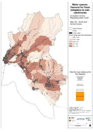
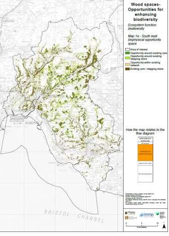
5 Green spaces: space for wellbeing Water Space: Natural Flood Management Blue space: Safe bathing waters by managing coastal pollution Wood space: Woodland planting
 Demand Space (e.")
6 Scale issues Moving from the whole of Wales to an Regional Area Approach Opportunity space: Biophysical opportunity space (e.g where is it possible to restore bogs) Demand Space (e.g where there is a flooding problem)


7 Demand and the rivers Rheidol and Ystwyth Rheidol Ystwyth
8 What is the Framework for best practice: To highlight methods and best practice Clickable document Flowchart to show decision making and guides users through the thinking and evidence behind the mapping Set of example maps to illustrate how you can interpret possible outputs derived from the framework
9 How to read the framework Introduction Preparatory questions Themes Scenario examples Multi-benefit opportunity mapping How to use the framework and background to the ecosystem approach and area statements These questions help you think through the high level questions you need to understand before you start mapping spatially These four themes take you through the concepts behind spatial mapping of ecosystem services How you use spatial mapping to look at possible futures to being to explore issues with stakeholders How to put the maps together to show the spaces where multi-benefits accrue from land management actions

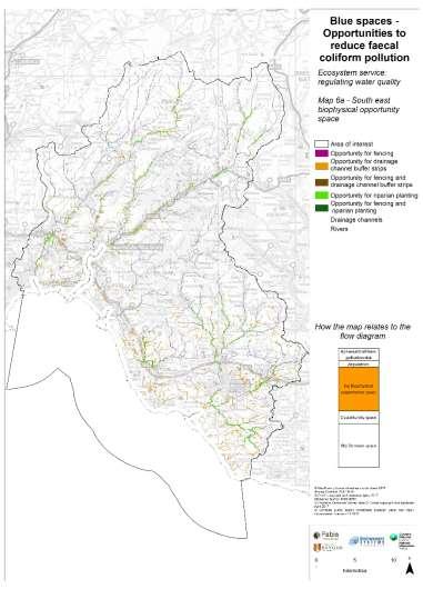
10 Hypothesis: Livestock with access to streams add to the burden of faecal coliform Evidence: Scoring for this data highlights risk of faecal coliform inputs from agricultural land (improved grassland) only and subsequent requirement for fencing where there is a risk of inputs. [7] Additional data / knowledge gaps are built in. [7] Tyrrel, S.F. and Quinton, J.N.. Overland flow transport of pathogens from agricultural land receiving faecal wastes

11 Evidence Stream
12
13

14 The example maps
15 Biophysical Opportunities Demand maps

16


17 Developing new sorts of data sets to link to the well being agenda

18 Scenarios

19
20 Economic Valuation Example of how to apply economic evaluation to the mapping showing examples from other projects How the spatial element of economic value is important
21 Conclusion The frameworks have been created so that anyone with a GIS tool can use the approach as it can be adopted by users of various packages and levels of expertise The framework and examples allow usage by a wide spectrum of people, not everyone can or will want to do everything. This work builds capacity and understanding The flow charts and evidence base ensure the theory and methods are transparent and adaptable into the future The methods can be used for scenario modelling and for economic evaluation. Success for this project would be for a variety of stakeholders to take up a more spatially orientated decision making.


22 Thank You
Possibilities for applying ES assessment results in spatial planning in Latvia
 Possibilities for applying ES assessment results in spatial planning in Latvia Inga Hoņavko LIFE EcosystemServices project manager LIFE Viva Grass seminar, Sigulda, 17.05.2018 Projekts LIFE EcosystemServices,
Framework on reducing diffuse pollution from agriculture perspectives from catchment managers
 Framework on reducing diffuse pollution from agriculture perspectives from catchment managers Photo: River Eden catchment, Sim Reaney, Durham University Introduction This framework has arisen from a series
National Land Use Policy and National Integrated Planning Framework for Land Resource Development
 Title National Land Use Policy and National Integrated Planning Framework for Land Resource Development Duration: 32 Weeks Objective: Adoption of appropriate land use planning approaches to: Maintain the
KUNMING FORUM ON UNITED NATIONS GLOBAL GEOSPATIAL INFORMATION MANAGEMENT CITIES OF THE FUTURE: SMART, RESILIENT
 KUNMING FORUM ON UNITED NATIONS GLOBAL GEOSPATIAL INFORMATION MANAGEMENT CITIES OF THE FUTURE: SMART, RESILIENT and SUSTAINABLE Yunnan Zhenzhuang Guest House, Kunming, China 10 12 May 2017 BACKGROUND CONCEPT
EcoServ-GIS. EcoServ GIS Stage I. Why EcoServ GIS? 17/12/2012
 EcoServ-GIS Ecosystem Services Mapping: A Wildlife Trust GIS Toolkit to map ecosystem services at a county scale Dr Jonathan Winn Living Landscape Coordinator Durham Wildlife Trust Dr Chloe Bellamy Ecosystem
Fig 1. Steps in the EcoValue Project
 Assessing the Social and Economic Value of Ecosystem Services in the Northern Forest Region: A Geographic Information System (GIS) Approach to Landscape Valuation Principal Investigator(s): Dr. Matthew
Empowered lives. Resilient nations. Data for People and Planet. powered by
 Empowered lives. Resilient nations. Data for People and Planet powered by Overview As we enter the fourth industrial revolution, technology is revolutionizing our ability to map nature. Satellite data
Natural Resource Management Strategy. Southern Tasmania. Summary. Natural Resource Management Strategy for Southern Tasmania Summary
 Natural Resource Management Strategy Summary Southern Tasmania 2015 2020 Natural Resource Management Strategy for Southern Tasmania 2015 2020 - Summary i Disclaimer In developing this Strategy, every effort
Assessment and valuation of Ecosystem Services for decision-makers
 Assessment and valuation of Ecosystem Services for decision-makers An introduction to the ARIES approach Ferdinando Villa *, Ken Bagstad Gary Johnson, Marta Ceroni *Basque Center for Climate Change, Bilbao,
Summary. Recommendations on the Fifth Policy Document on Spatial Planning September 2001
 Summary Recommendations on the Fifth Policy Document on Spatial Planning September 2001 2 Introduction In December 2000 the Dutch Cabinet issued Part 1 of the Fifth National Policy Document on Spatial
Most people used to live like this
 Urbanization Most people used to live like this Increasingly people live like this. For the first time in history, there are now more urban residents than rural residents. Land Cover & Land Use Land cover
Towards a National Ecosystem Services Strategy for Australia
 Towards a National Ecosystem Services Strategy for Australia Peter Ampt, Simone Maynard, Geoff Gorrie, Philippa Rowland, Allan Dale, Jeremy Thompson, Steve Cork, Bob Douglas, Lynne Reeder Australia 21
GIS as a tool in flood management
 GIS for the United Nations and the International Community Conference Panel: GIS and Capacity - How Territorial Planning Benefits from Geospatial Information 3-5 April 2012 Geneva, Switzerland GIS as a
Key Indicators for Territorial Cohesion and Spatial Planning in Preparing Territorial Development Strategies
 ESPON Evidence in a North European Context Challenges and Opportunities for Territorial Development and Cohesion in a North European Macro Region, 10-11 April, 2014, Vilnius, Lithuania Key Indicators for
Establishment of the Hellenic Ecosystem Services Partnership (HESP) research group: Drafting the national agenda for the implementation of the
 research group: Drafting the national agenda for the implementation of the") Establishment of the Hellenic Ecosystem Services Partnership (HESP) research group: Drafting the national agenda for the implementation of the ES concept in Greece Establishment of the Hellenic Ecosystem
Establishment of the Hellenic Ecosystem Services Partnership (HESP) research group: Drafting the national agenda for the implementation of the ES concept in Greece Establishment of the Hellenic Ecosystem
3/29/11. Why bother with tools? Incorporating Decision Support Tools into Climate Adaptation Planning. A Simplified Planning Process
 Incorporating Decision Support Tools into Climate Adaptation Planning Why bother with tools? Tools don t eliminate complexity but they can help deal with it" Tools can:"! Help incorporate science into
GIS Building Communities beyond National Borders (Building Successful Spatial Data Infrastructures) Nick Land, ESRI Europe
 Nick Land, ESRI Europe") GIS Building Communities beyond National Borders (Building Successful Spatial Data Infrastructures) Nick Land, ESRI Europe UK worst flooding in the last 60 years 350,000 households without drinking water
GIS Building Communities beyond National Borders (Building Successful Spatial Data Infrastructures) Nick Land, ESRI Europe UK worst flooding in the last 60 years 350,000 households without drinking water
Taking the Bite out of Wetlands
 Taking the Bite out of Wetlands Valuing Nature Annual Conference Tim Acott, University of Greenwich Tuesday 18 th October 2016 Manchester Central Complex, M2 3GX The Project Taking the bite out of wetlands:
Human-nature interactions and the coproduction of ecosystem services
 Human-nature interactions and the coproduction of ecosystem services Anke Fischer Social, Economic and Geographical Sciences Group James Hutton Institute Aberdeen @HuttonSEGS Conserving biodiversity, and
Implementing the Sustainable Development Goals: The Role of Geospatial Technology and Innovation
 Fifth High Level Forum on UN Global Geospatial Information Management Implementing the Sustainable Development Goals: The Role of Geospatial Technology and Innovation 28-30 November 2017 Sheraton Maria
Geographic Information Infrastructure and Policy Framework for Sustainable Mountain Development in the Hindu Kush-Himalayas
 Geo SMART ASIA 2017 22-24 August, Kualalampur Geographic Information Infrastructure and Policy Framework for Sustainable Mountain Development in the Hindu Kush-Himalayas Basanta Shrestha, Director Strategic
The UN-GGIM: Europe core data initiative to encourage Geographic information supporting Sustainable Development Goals Dominique Laurent, France
 INSPIRE conference Strasbourg 6 September 2017 The UN-GGIM: Europe core data initiative to encourage Geographic information supporting Sustainable Development Goals Dominique Laurent, France Introduction
Hydrologic Analysis for Ecosystem Restoration
 Hydrologic Analysis for Ecosystem Restoration Davis, California Objectives: To provide participants with: 1) an understanding of the issues in restoration studies; 2) an overview of Corps policies and
Biodiversity and Ecosystem services Thinking globally, acting locally
 Biodiversity and Ecosystem services Thinking globally, acting locally Anne-Gaelle Ausseil - Manaaki Whenua Landcare Research Geoff Hicks National Commission for UNESCO 1 8 / 1 0 / 2 0 1 8 M A N A A K I
THE ROLE OF GEOSPATIAL AT THE WORLD BANK
 THE ROLE OF GEOSPATIAL AT THE WORLD BANK INSPIRE Conference Barcelona, Spain September 26, 2016 Kathrine Kelm Senior Land Administration Specialist Global Land and Geospatial Unit The World Bank Group
Mapping and Assessment of Ecosystems and their Services
 Mapping and Assessment of Ecosystems and their Services ALTER-Net Conference 2013: Science underpinning the EU 2020 Biodiversity Strategy. April 2013 Gent Joachim MAES 1 This presentation is based on the
Governance and Urban Nexus: Closing the gaps
 Governance and Urban Nexus: Closing the gaps Donovan Storey Chief, Sustainable Urban Development, Environment & Development Division National Dialogue on Urban Nexus in Thailand Bangkok, UNCC, 19 March
Designing Networks of Marine Protected Areas in DFO s Three Atlantic Bioregions
 Designing Networks of Marine Protected Areas in DFO s Three Atlantic Bioregions Presentation for Indigenous Protected Areas Workshop Max Westhead, DFO and Adrian Gerhartz-Abraham, Dalhousie March 29, 2017
TOWARDS CLIMATE-RESILIENT COASTAL MANAGEMENT: OPPORTUNITIES FOR IMPROVED ICZM IN BELIZE
 TOWARDS CLIMATE-RESILIENT COASTAL MANAGEMENT: OPPORTUNITIES FOR IMPROVED ICZM IN BELIZE CHANTALLE SAMUELS Coastal Zone Management Authority and Institute The Caribbean Community Climate Change Centre VULNERABILITY
15 March 2010 Re: Draft Native Vegetation of the Sydney Metropolitan Catchment Management Authority Area GIS layers and explanatory reports
 SYDNEY COASTAL COUNCILS GROUP Inc. C/- City of Sydney Council Level 14, 456 Kent Street GPO Box 1591, SYDNEY NSW 2001 Phone: (02) 9246 7791 Facsimile: (02) 9265 9660 Email: info@sydneycoastalcouncils.com.au
Developing urban ecosystem accounts for Great Britain. Emily Connors Head of Natural Capital Accounting Office for National Statistics (UK)
") Developing urban ecosystem accounts for Great Britain Emily Connors Head of Natural Capital Accounting Office for National Statistics (UK) UN 2014 UN 2014 ONS 2017 UK motivation 54% 82% 5,900 Of the world
Developing urban ecosystem accounts for Great Britain Emily Connors Head of Natural Capital Accounting Office for National Statistics (UK) UN 2014 UN 2014 ONS 2017 UK motivation 54% 82% 5,900 Of the world
The Integrated Ge spatial Information Framework to the strengthening of NSDI, Mongolia
 Young Geospatial Professionals Summit 21 NOV 2018 The Integrated Ge spatial Information Framework to the strengthening of NSDI, Mongolia BAYARMAA ENKHTUR Geospatial information and technology department
Status of implementation of the INSPIRE Directive 2016 Country Fiches. COUNTRY FICHE Netherlands
 Status of implementation of the INSPIRE Directive 2016 Country Fiches COUNTRY FICHE Netherlands Introduction... 1 1. State of Play... 2 1.1 Coordination... 2 1.2 Functioning and coordination of the infrastructure...
Land Resources Planning (LRP) Toolbox User s Guide
 Toolbox User s Guide") Land Resources Planning (LRP) Toolbox User s Guide The LRP Toolbox is a freely accessible online source for a range of stakeholders, directly or indirectly involved in land use planning (planners, policy
Land Resources Planning (LRP) Toolbox User s Guide The LRP Toolbox is a freely accessible online source for a range of stakeholders, directly or indirectly involved in land use planning (planners, policy
Spatial Planning in Canada s Maritimes Region. Maritimes Region
 Spatial Planning in Canada s Maritimes Region Glen Herbert, Scott Coffen-Smout Smout,, and Tanya Koropatnick Oceans and Coastal Management Division Ecosystem Management Branch Fisheries and Oceans Canada
Outline National legislative & policy context Regional history with ESSIM ESSIM Evaluation Phase Government Integration via RCCOM Regional ICOM Framew
 What MSP Implementation could change in the Maritimes Region Tim Hall, Regional Manager Oceans and Coastal Management Division Ecosystem Management Branch Fisheries and Oceans Canada Maritimes Region BIO
Ecological Valuation for Land Use Planning Decision Support in South Florida: The Ecosystem Portfolio Model
 Ecological Valuation for Land Use Planning Decision Support in South Florida: The Ecosystem Portfolio Model Bill Labiosa, Rich Bernknopf, Paul Hearn, Dianna Hogan, Dave Strong, Leonard Pearlstine, Amy
Visualization tools for coastal climate change vulnerability assessment and adaptation guidelines: a case study in Cartagena, Colombia
 Visualization tools for coastal climate change vulnerability assessment and adaptation guidelines: a case study in Cartagena, Colombia Vivian Ochoa, Paula Cristina Sierra-Correa, Venus Rocha, Francisco
FINDINGS OF THE ARCTIC METEOROLOGY SUMMIT
 FINDINGS OF THE ARCTIC METEOROLOGY SUMMIT 2018 WWW.FMI.FI CHAIR S SUMMARY: 1 2 3 We need to be curious to explore the known unknowns. Meteorology is an elemental part of international collaboration in
Natural Resource Management. Northern Tasmania. Strategy. Appendix 2
 Natural Resource Management Strategy Northern Tasmania 2015 2020 Appendix 2 Appendix 2 Appendix 2. Carbon Planting Spatial Prioritisation In support of this Strategy s development and implementation, work
Birch Creek Geomorphic Assessment and Action Plan
 Birch Creek Geomorphic Assessment and Action Plan Jim Webster Tim Hanrahan, PhD, CFM Jesse Schwartz, PhD Zach Hill January 22, 2015 White Eagle Grange This Project is a First Step in Strategy Planning
Key Indicators for Territorial Cohesion & Spatial Planning Stakeholder Workshop - Project Update. 13 th December 2012 San Sebastián, Basque Country
 Key Indicators for Territorial Cohesion & Spatial Planning Stakeholder Workshop - Project Update 13 th December 2012 San Sebastián, Basque Country Key Aims Explore the use of territorial data in developing
SEEA Experimental Ecosystem Accounting
 SEEA Experimental Ecosystem Accounting Sokol Vako United Nations Statistics Division Training for the worldwide implementation of the System of Environmental Economic Accounting 2012 - Central Framework
OUR COASTAL FUTURES. A Strategy for the Sustainable Development of the World s Coasts.
 OUR COASTAL FUTURES A Strategy for the Sustainable Development of the World s Coasts www.futureearthcoasts.org Iqaluit, Nunavut, Canada. Photo by Don Forbes Coastal zones are the frontline in our global
16540/14 EE/cm 1 DG E 1A
 Council of the European Union Brussels, 5 December 2014 (OR. en) 16540/14 ENV 965 CULT 139 NOTE From: To: Subject: General Secretariat of the Council Delegations Charter of Rome on Natural and Cultural
European Topic Centre on Land Urban and Soil Systems. Green Infrastructure at EEA
 Green Infrastructure at EEA A SPATIAL APPROACH TO MAPPING GI Stefan Kleeschulte, ETC ULS GI and territorial cohesion 2011 first EEA report on Green Infrastructure Underlining the need to develop tools
Asia Protected Areas Charter
 資料 3-1 Asia Protected Areas Charter The Asia Challenge Asia is the world s most rapidly growing region as well as one of the most bio-diverse. This dynamic development has led to unprecedented growth,
Opportunities to Improve Ecological Functions of Floodplains and Reduce Flood Risk along Major Rivers in the Puget Sound Basin
 Opportunities to Improve Ecological Functions of Floodplains and Reduce Flood Risk along Major Rivers in the Puget Sound Basin Christopher Konrad, US Geological Survey Tim Beechie, NOAA Fisheries Managing
Land Use in the context of sustainable, smart and inclusive growth
 Land Use in the context of sustainable, smart and inclusive growth François Salgé Ministry of sustainable development France facilitator EUROGI vice president AFIGéO board member 1 Introduction e-content+
Overview of LEDDRA. Three years of research on responses to LEDD
 Overview of LEDDRA Three years of research on responses to LEDD, Coordinating institution (Greece) Project partners Agricultural University of Athens (Greece) 3D-Environmental Change (The Netherlands)
Catchment Guide Appendix 2: Case Studies
 Catchment Guide Appendix 2: Case Studies List of Case Studies 1. Ribble Catchment Online Information 2. Upper Thames Catchment Integrated Local Delivery The Ribble Catchment Question 8: What information
A Spatial Decision Support System for Agriculture and Natural Resources Management in China
 9 th APGEOSS Symposium Xiangzheng Deng A Spatial Decision Support System for Agriculture and Natural Resources Management in China Need to take decisions and make critical day-to-day and long-term planning
UPTAKE AND PATHWAYS OF COASTAL ADAPTATION PROCESSES IN AUSTRALIA
 2015 Effect of Climate Change on the World's Oceans - Santos, Brazil UPTAKE AND PATHWAYS OF COASTAL ADAPTATION PROCESSES IN AUSTRALIA COASTAL COLLABORATION CLUSTER: MEETING COASTAL CHALLENGES Débora M.
Assessment of Sustainable Land Use within the Town Planning Process Experiences with a Multi Criteria Approach (MCA)
") Assessment of Sustainable Land Use within the Town Planning Process Experiences with a Multi Criteria Approach (MCA) Dipl.-Geogr. Sophie Schetke Dipl.-Ing. Benedikt Frielinghaus, University of Bonn, Germany
Assessment of Sustainable Land Use within the Town Planning Process Experiences with a Multi Criteria Approach (MCA) Dipl.-Geogr. Sophie Schetke Dipl.-Ing. Benedikt Frielinghaus, University of Bonn, Germany
What is Spatial Planning?
 Spatial Planning in the context of the Responsible Governance of Tenure What is Spatial Planning? Text-only version This course is funded by the European Union through the EU-FAO Improved Global Governance
Building Institutional Capacity for Multi-Hazard Early Warning in Pacific Countries Subtitle
 Building Institutional Capacity for Multi-Hazard Early Warning in Pacific Countries Subtitle Title Keran Wang Chief, Space Applications Section ICT and Disaster Risk Reduction Division 30 March 2018 Slide
DELIVERING ECOSYSTEM- BASED MARINE SPATIAL PLANNING IN PRACTICE
 DELIVERING ECOSYSTEM- BASED MARINE SPATIAL PLANNING IN PRACTICE A first assessment for the UK and Ireland January 08 GLOBAL WARMING IMAGES / WWF ABOUT WWF WWF is the world s leading independent conservation
ROSS ECOSYSTEM VALUATION FRAMEWORK. TECHNICAL WORK SESSION June 12 th, 2013 FRAMEWORK DEVELOPMENT TO SUPPORT DECISION MAKING
 ECOSYSTEM VALUATION FRAMEWORK ROSS TECHNICAL WORK SESSION June 12 th, 2013 FRAMEWORK DEVELOPMENT TO SUPPORT DECISION MAKING CENTRAL PUGET SOUND REGIONAL OPEN SPACE SYSTEM (ROSS) Understand how landscape
Urbanization and Sustainable Development of Cities: A Ready Engine to Promote Economic Growth and Cooperation
 Urbanization and Sustainable Development of Cities: A Ready Engine to Promote Economic Growth and Cooperation Wan Portia Hamzah Institute of Strategic and International Studies (ISIS) Malaysia 10 September
Liana Talaue McManus. Division of Marine Affairs and Policy Rosenstiel School of Marine & Atmospheric Science University of Miami
 Liana Talaue McManus Division of Marine Affairs and Policy Rosenstiel School of Marine & Atmospheric Science University of Miami Outline 1. Coasts as vulnerable & resilient social ecological systems 2.
Spatial Units (Level 1)
") Spatial Units (Level 1) Project: Advancing the SEEA Experimental Ecosystem Accounting Overview: Spatial Units 1. Learning objectives 2. Review of Level 0 (5m) 3. Level 1 (Compilers): Presentation & group
Spatial Units (Level 1) Project: Advancing the SEEA Experimental Ecosystem Accounting Overview: Spatial Units 1. Learning objectives 2. Review of Level 0 (5m) 3. Level 1 (Compilers): Presentation & group
Ecological Land Cover Classification For a Natural Resources Inventory in the Kansas City Region, USA
 Ecological Land Cover Classification For a Natural Resources Inventory in the Kansas City Region, USA by Applied Ecological Services, Inc. In cooperation with the Mid-America Regional Council 600 Broadway,
Restoring Rivers in Cumbria Online Story Map of a case study on the River Lyvennet
 Restoring Rivers in Cumbria Online Story Map of a case study on the River Lyvennet Summary This Story Map presents a river restoration case study for the River Eden Catchment, Cumbria. Students can learn
DEPARTMENT OF GEOLOGY AND MINERAL INDUSTRIES WAYS & MEANS SUBCOMMITTEE ON NATURAL RESOURCES MARCH 2, 2017
 DEPARTMENT OF GEOLOGY AND MINERAL INDUSTRIES WAYS & MEANS SUBCOMMITTEE ON NATURAL RESOURCES MARCH 2, 2017 1 ABOUT DOGAMI AGENCY MISSION, VISION & GOALS 2 Lidar image of a stream network along the Umpqua
Curriculum Links AS and A level Field Studies
 Equipment Includes Human Geography Coastal Management Students examine the conflicts that arise from coastal erosion and the options for coastal management. They investigate different types of coastal
A land management decision support tool and ecosystem process modelling framework
 A land management decision support tool and ecosystem process modelling framework Bethanna Jackson, Bridget Emmett, David Cooper, Lindsay Maskell, + more Services currently modelled by LUCI Service Production
Physical Geography: Patterns, Processes, and Interactions, Grade 11, University/College Expectations
 Geographic Foundations: Space and Systems SSV.01 explain major theories of the origin and internal structure of the earth; Page 1 SSV.02 demonstrate an understanding of the principal features of the earth
Visualizing Upper Trophic and Ecosystem Modeling Outputs with EverVIEW to Inform the Decision Process in Coastal Louisiana.
 Visualizing Upper Trophic and Ecosystem Modeling Outputs with EverVIEW to Inform the Decision Process in Coastal Louisiana 2012 Master Plan Craig Conzelmann Carol Parsons Richards Kevin Suir COMPREHENSIVE
Spatial units (Levels 0 and 1)
") Spatial units (Levels 0 and 1) Project: Advancing the SEEA Experimental Ecosystem Accounting Overview: Spatial units 1. Learning objectives 2. Level 1: Presentation & group exercise Spatial units (10m
Spatial units (Levels 0 and 1) Project: Advancing the SEEA Experimental Ecosystem Accounting Overview: Spatial units 1. Learning objectives 2. Level 1: Presentation & group exercise Spatial units (10m
06/04/2015. Overview: Spatial units. Advancing the SEEA Experimental Ecosystem Accounting Spatial units (Level 1)
") Advancing the SEEA Experimental Ecosystem Accounting Spatial units (Level 1) Advancing the SEEA-EEA Project Overview: Spatial units 1. Learning objectives 2. Level 1: Presentation & group exercise Spatial
Advancing the SEEA Experimental Ecosystem Accounting Spatial units (Level 1) Advancing the SEEA-EEA Project Overview: Spatial units 1. Learning objectives 2. Level 1: Presentation & group exercise Spatial
EnviroAtlas: An Atlas about Ecosystems and their Connection with People
 EnviroAtlas: An Atlas about Ecosystems and their Connection with People Annie Neale, Megan Mehaffey & Atlas Team ASWM Webinar October, 17 th, 2012 What is it? The Atlas is an online decision support tool
COMMON CONCEPTUAL AND OPERATIONAL FRAMEWORKS FOR RESEARCH AND SUSTAINABLE MANAGEMENT OF NESTED SOCIO-ECOLOGICAL SYSTEMS ACROSS LARGE WATERSHEDS
 COMMON CONCEPTUAL AND OPERATIONAL FRAMEWORKS FOR RESEARCH AND SUSTAINABLE MANAGEMENT OF NESTED SOCIO-ECOLOGICAL SYSTEMS ACROSS LARGE WATERSHEDS Angheluta VADINEANU 1 & Nusret KARAKAYA 2 1 Department of
Biodiversity Blueprint Overview
 Biodiversity Blueprint Overview Climate Variability Climate projections for the Glenelg Hopkins Regions suggest that the weather will be hotter and drier in the coming years which will impact on land use,
Urban Climate Resilience
 Urban Climate Resilience in Southeast Asia Partnership Project Introduction Planning for climate change is a daunting challenge for governments in the Mekong Region. Limited capacity at the municipal level,
ESTIMATING THE SOCIAL & ENVIRONMENTAL EFFECTS OF ADVENTURE TOURISM AND RECREATION ON CROWN LAND IN BRITISH COLUMBIA
 ESTIMATING THE SOCIAL & ENVIRONMENTAL EFFECTS OF ADVENTURE TOURISM AND RECREATION ON CROWN LAND IN BRITISH COLUMBIA Wolfgang Haider School of Resource and Environmental Mgt. Simon Fraser University Burnaby,
Spatial decision making in Armenia based on multidisciplinary environmental research
 EU FP7 EcoArm2ERA Integration into ERA Integration of spatial decision support systems and evidence based modeling in National/Regional Policy applications and regulatory systems: scientific and policy
What s the problem? A Modern Odyssey in Search of Relevance. The search for relevance. Some current drivers for new services. Some Major Applications
 A Modern Odyssey in Search of Relevance FIG Working Week, Athens, 24 May 2004 Paul Kelly ANZLIC Executive Director The search for relevance 1. New expectations for spatial services 2. Are we ready to meet
EcoServ-GIS. Ecosystem Services Mapping: A Wildlife Trust GIS Toolkit to map ecosystem services at a county scale
 EcoServ-GIS Ecosystem Services Mapping: A Wildlife Trust GIS Toolkit to map ecosystem services at a county scale Dr Jonathan Winn Living Landscape Coordinator Durham Wildlife Trust Dr Chloe Bellamy Ecosystem
GIS-Based Sediment Quality Database for the St. Louis River Area of Concern (AOC): Overview Presentations and Demonstration
: Overview Presentations and Demonstration") GIS-Based Sediment Quality Database for the St. Louis River Area of Concern (AOC): Overview Presentations and Demonstration Judy L. Crane 1 and Dawn E. Smorong 2 1 Minnesota Pollution Control Agency, St.
GIS-Based Sediment Quality Database for the St. Louis River Area of Concern (AOC): Overview Presentations and Demonstration Judy L. Crane 1 and Dawn E. Smorong 2 1 Minnesota Pollution Control Agency, St.
Weather Climate Science to Service Partnership South Africa
 PROJECTS UNDERWAY Title of the Weather Climate Science to Service Partnership South Africa Together, building on an existing strong partnership, South African Weather Service and the Met Office will build
Creating a Staff Development Plan with Esri
 Creating a Staff Development Plan with Esri Michael Green David Schneider Guest Presenter: Shane Feirer, University of California Esri UC 2014 Technical Workshop Agenda What is a Staff Development Plan?
Presentation by Thangavel Palanivel Senior Strategic Advisor and Chief Economist UNDP Regional Bureau for Asia-Pacific
 Presentation by Thangavel Palanivel Senior Strategic Advisor and Chief Economist UNDP Regional Bureau for Asia-Pacific The High-Level Euro-Asia Regional Meeting on Improving Cooperation on Transit, Trade
Maritime Spatial Planning
 Maritime Spatial Planning The Dutch experience Kopenhagen 28 november 2012 Lodewijk.Abspoel@minienm.nl North Sea 2 Outline History of MSP in the Netherlands Spatial Plan for the Dutch EEZ, principles and
Spatial Data Availability Energizes Florida s Citizens
 NASCIO 2016 Recognition Awards Nomination Spatial Data Availability Energizes Florida s Citizens State of Florida Agency for State Technology & Department of Environmental Protection Category: ICT Innovations
ERA-NET CRUE Funding Initiative. Risk Assessment and Risk Management in Small Urban Catchments
 ERA-NET CRUE Funding Initiative Integrate, Consolidate and Disseminate European Flood Risk Management Research Kick-off Meeting of Research Projects Risk Assessment and Risk Management in Small Urban Catchments
INTEGRATION OF LUTI MODELS IN SUSTAINABLE URBAN MOBILITY PLANS
 Proceedings of the 14 th International Conference on Environmental Science and Technology Rhodes, Greece, 3-5 September 2015 INTEGRATION OF LUTI MODELS IN SUSTAINABLE URBAN MOBILITY PLANS GAVANAS N. 1,
Preliminary Vulnerability Assessment of Coastal Flooding Threats - Taylor County, Florida
 Preliminary Vulnerability Assessment of Coastal Flooding Threats - Taylor County, Florida North Central Florida Regional Planning Council Northeast Florida Regional Council April 28, 2016 BACKGROUND This
EXPLORING COMMON SOLUTIONS IN ARCTIC METEOROLOGY FINLAND S CHAIRMANSHIP OF THE ARCTIC COUNCIL
 EXPLORING COMMON SOLUTIONS IN ARCTIC METEOROLOGY FINLAND S CHAIRMANSHIP OF THE ARCTIC COUNCIL 2017 2019 GENERAL OBJECTIVES Finland chairs the Arctic Council in 2017-2019. One of the chairmanship priorities
AP ENVIRONMENTAL SCIENCE 2013 SCORING GUIDELINES [14 pt space] Question 1
![AP ENVIRONMENTAL SCIENCE 2013 SCORING GUIDELINES [14 pt space] Question 1](/thumbs/77/74883235.jpg "AP ENVIRONMENTAL SCIENCE 2013 SCORING GUIDELINES [14 pt space] Question 1") AP ENVIRONMENTAL SCIENCE 2013 SCORING GUIDELINES [14 pt space] Question 1 (a) Identify TWO human activities that alter the natural flow of sediments into Gulf Coast ecosystems. Explain how each of the
AP ENVIRONMENTAL SCIENCE 2013 SCORING GUIDELINES [14 pt space] Question 1 (a) Identify TWO human activities that alter the natural flow of sediments into Gulf Coast ecosystems. Explain how each of the
SPLAN-Natura Towards an integrated spatial planning approach for Natura th January, 2017 Brussels. Commissioned by DG Environment
 SPLAN-Natura 2000 Towards an integrated spatial planning approach for Natura 2000 Commissioned by DG Environment 17 th January, 2017 Brussels V. Simeonova (Ph.D.) Drivers towards integrating Biodiversity
Esri and GIS Education
 Esri and GIS Education Organizations Esri Users 1,200 National Government Agencies 11,500 States & Regional Agencies 30,800 Cities & Local Governments 32,000 Businesses 8,500 Utilities 12,600 NGOs 11,000
UN-GGIM: Strengthening Geospatial Capability
 Fifth Plenary Meeting of UN-GGIM: Europe Brussels, 6-7 June 2018 UN-GGIM: Strengthening Geospatial Capability Walking the talk to leave no one behind Greg Scott, UN-GGIM Secretariat Environmental Statistics
sentinel-2 COLOUR VISION FOR COPERNICUS
 sentinel-2 COLOUR VISION FOR COPERNICUS SATELLITES TO SERVE By providing a set of key information services for a wide range of practical applications, Europe s Copernicus programme is providing a step
Applying GIS to Coastal Management in Cork Harbour: the Corepoint experience
 Applying GIS to Coastal Management in Cork Harbour: the Corepoint experience Kathrin Köpke University College Cork, Ireland Thematic Conference: THE WATERFRONT MANAGEMENT AND GI (IT), 14 th -18 th November
Barnabas Chipindu, Department of Physics, University of Zimbabwe
 DEFICIENCIES IN THE OPERATIONAL APPLICATIONS OF LONG - RANGE WEATHER PREDICTIONS FOR AGRICULTURE - RECOMMENDATIONS FOR IMPROVING THE TECHNOLOGY FOR THE BENEFIT OF AGRICULTURE AT THE NATIONAL AND REGIONAL
NSW Education Standards Authority. Geography Geography Life Skills Stage 6 Draft Directions for Syllabus Development
 NSW Education Standards Authority Geography Geography Life Skills Stage 6 Draft Directions for Syllabus Development for Consultation 23 July 2018 2 September 2018 2018 NSW Education Standards Authority
Environmental Management Information System (EMIS)
") United Nations Human Settlements Programme (UN-HABITAT) United Nations Environment Programme (UNEP) Environmental Management Information System (EMIS) a tool for Environmental Planning and Management (EPM)
United Nations Human Settlements Programme (UN-HABITAT) United Nations Environment Programme (UNEP) Environmental Management Information System (EMIS) a tool for Environmental Planning and Management (EPM)
Chisoni Mumba. Presentation made at the Zambia Science Conference 2017-Reseachers Symposium, th November 2017, AVANI, Livingstone, Zambia
 Application of system dynamics and participatory spatial group model building in animal health: A case study of East Coast Fever interventions in Lundazi and Monze districts of Zambia Chisoni Mumba Presentation
ROLE OF SPATIAL PLANNING TOOLS AT MESO-SCALE IN THE MANAGEMENT OF NATURAL RESOURCES, LESSONS LEARNT FROM AFRICAN COUNTRIES
 6th Nov, 2012 ROLE OF SPATIAL PLANNING TOOLS AT MESO-SCALE IN THE MANAGEMENT OF NATURAL RESOURCES, LESSONS LEARNT FROM AFRICAN COUNTRIES Masoom Hamdard Environmental Planning and Assessment for Adaptation
Introduction and Project Overview
 Greater New Orleans Regional Land Use Modeling GIS Techniques in a P olitical C ontext Louisiana Remote Sensing and GIS Workshop Wednesday, April 24, 2013 Working Towards a Shared Regional Vision Introduction