Chisoni Mumba. Presentation made at the Zambia Science Conference 2017-Reseachers Symposium, th November 2017, AVANI, Livingstone, Zambia
|
|
|
- Homer Evans
- 5 years ago
- Views:
Transcription
1 Application of system dynamics and participatory spatial group model building in animal health: A case study of East Coast Fever interventions in Lundazi and Monze districts of Zambia Chisoni Mumba Presentation made at the Zambia Science Conference 2017-Reseachers Symposium, th November 2017, AVANI, Livingstone, Zambia Theme: The role of Human Behaviour and environmental contextual issues in developing successful disease control Interventions in Livestock systems
2 Overview Initial focus: describe practices of traditional beef farmers in their production & marketing of cattle in Zambia Started as a big survey (n=770) to identify problem ECF most economically important production disease Despite the disease control efforts by stakeholders, ECF cases are increasing Research Question: Why does ECF oscillate over time? Can alternative approaches such as systems thinking contribute solutions to the complex ECF problem? To answer these research questions and inform the design & implementation of ECF interventions, We qualitatively investigated the influence of dynamic socioeconomic, cultural, and ecological contextual issues
3 Overview (2) Need for tools to assess these issues (research gap) Role of system dynamics (SD): a computer aided approach to policy analysis and design Interdisciplinary in nature & applies to dynamic problems arising in complex social, managerial, economic or ecological systems SD models can be developed through literature review, interviews and meetings Group model building (GMB) - use of communities/stakeholders in model conceptualization, formulation, analysis, & decision making SGMB - a new modification of a standard GMB highlighting spatial context of system
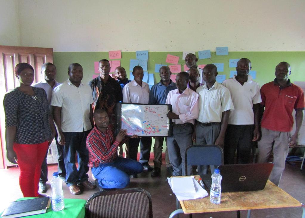
4 Overview (3) SGMB sessions applied facilitation tool called LayerStack developed at Lincoln University in NZ Used plastic acetates where each acetate denotes a data layer similar to a computer-based GIS. Helps stakeholders visualize many of the spatial factors of a particular research problem Eases facilitation process LayerStack enables SGMB to be done in any environment (e.g. outside, under a tree, etc.) Does not require use of computers, projectors, flip charts, or whiteboards like ordinary GMB processes Useful for developing countries
5 Methodology-Theories driving SD Grounded on 2 theories; personal construct & nonlinear dynamics (Sterman, 2000; Vennix, 1996) PC theory is a cognitive theory that defines every man as a scientist, who collects data to understand the world and creates mental models to predict the problem and control it (Kelly 1955) This is based on the fact that every man thinks & Thinking is the construction of mental models and simulating them in order to draw conclusions and make decisions (Richmond 2013) Mental models are images that we carry in our minds to simplify a representation of complex systems (Ford, 2010)
6 Theory of Nonlinear dynamics Spencer-wood, (2013) defines a dynamical nonlinear systems theory as, A paradigm in science that permits more accurate description and explanation of the evolution of most natural and cultural systems, patterns, and processes. This is because most systems are nonlinear to some extent
7 Why SGMB Since every man thinks (creates mental models), The use of SGMB makes SD mental models extremely close to reality as compared to desktop models (black box modelling) developed through literature review (Sterman, 2000) Improves quality of information received from stakeholders & Also grounds it spatially, providing more targeted details on the where of problems Allows bottom-up process of policy formulation & prioritization that take local needs into account Creates awareness, motivation, & platform for joint learning of solutions to common problems
8 Procedure of SGMB Script 1: Planning Script 2: Scene preparation Script 3: Introduction (hopes & fears) Script 4: Language of SD (concept models) Script 5: SGMB (facilitation tool) -Settlements, -Value chain actors & supporters, -Cattle production, -Cattle sales, -Disease -Household socioeconomic status Script 6: Problem identification (CLD, feedbacks) Script 7: Model development & simulation)

9 Pictorial description of SGMB
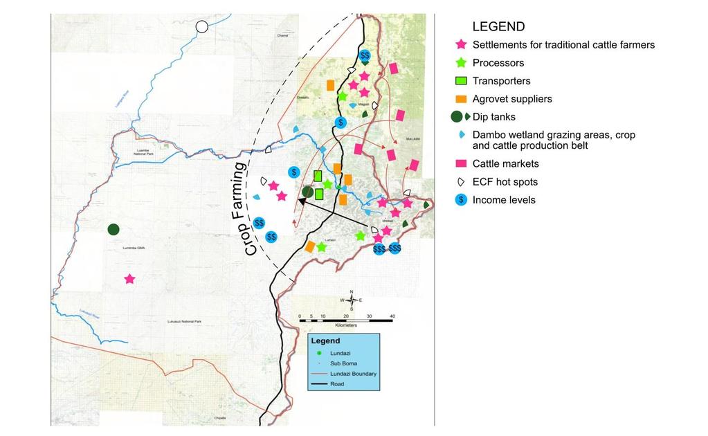
10 Digitised LayerStack
11 Learning outcomes from the SGMB process SGMB process revealed considerable diversity in the dynamic context of ECF due to differences in spatial patterns ECF interventions in Lundazi hindered by competition for land-use between crops & cattle Use of dip tanks obsolete, yet they are critical in keeping the host, vector and pathogen stable In Monze district, the model structure influenced by effects of climate change Climate change led to droughts & fewer floods that would otherwise provide an enabling environment for ticks & ECF parasite to thrive
12 Learning outcomes from the SGMB process The contrasts in access to cattle markets between the districts also influence ECF disease dynamics. E.g, in Monze district market is more internal while in Lundazi more externally-focused. External influence complicate effective ECF control interventions Variations in cultural shocks also influence ECF system behaviour Stigma associated with mixing of animals for cattle farmers of different social classes Effects stigma on dipping imply ECF is not only biologically determined but also socially constructed and maintained
13 Learning outcomes from the SGMB process Variations in agro-ecological zones & cattle herding practices also influence ECF system behaviour. Monze district practices transhumance cattle herding system in human-wildlife-livestock interface areas. The contact between cattle and wildlife in this system further complicates ECF disease control efforts
14 CLDs and Feedbacks
15 Modelling Process
16 Conclusions and Recommendations The spatial aspects and interactions of socio-economical, cultural, and ecological contextual issues play a critical role in designing and implementing effective and sustainable community-led ECF control policies These issues vary considerably across space and context, suggesting that a one-size-fits-all policy will not be effective The nature of disease and disease processes are just one part of the broader livestock system that includes market, socio-economic, and environmental factors. Household decisions made on the basis of social obligations, conventions, ethnic rivalry, or other household needs further thwart the technical, top-down efforts of policymakers to control disease
17 Conclusions and Recommendations These structures, and their interactions produce different patterns of disease endemicity over time, and which can be influenced by the introduction of public policies aimed at mitigating disease incidence From a policy perspective, SD models provide decision makers with insights on how interrelated factors /drivers influence disease patterns These insights are typically missing among decision-makers, We argue that a greater appreciation could help them develop policies that more effectively integrate technical solutions with socio-ecological interventions (e.g. farmer awareness, education, or specific socio-economic policies).
18 Policy leavers Internalising cattle sales through a creation of stable and sustainable markets Strategic immunisation and placement of dip tanks & establishing of veterinary infrastructure in cattle producing areas would help to change ECF system behaviour. Remedying social conflicts Involving stakeholders in policy design could improve the uptake of interventions Human development (population growth, urbanisation, agriculture) is a threat to biodiversity conservations. How do we deal with this?
19 Thank You
r10_summary.qxd :19 Page 245 ABOUT THE BOOK
 r10_summary.qxd 2011-08-28 21:19 Page 245 ABOUT THE BOOK The main strategic aim of most concepts of rural development is to improve the quality of life of rural residents through providing appropriate
Key Indicators for Territorial Cohesion & Spatial Planning Stakeholder Workshop - Project Update. 13 th December 2012 San Sebastián, Basque Country
 Key Indicators for Territorial Cohesion & Spatial Planning Stakeholder Workshop - Project Update 13 th December 2012 San Sebastián, Basque Country Key Aims Explore the use of territorial data in developing
Rural Sociology (RU_SOC)
") Rural Sociology (RU_SOC) 1 Rural Sociology (RU_SOC) RU_SOC 1000: Rural Sociology Introduction to basic concepts and principles of sociology with a focus on rural populations and places. The course explores
Rural Sociology (RU_SOC) 1 Rural Sociology (RU_SOC) RU_SOC 1000: Rural Sociology Introduction to basic concepts and principles of sociology with a focus on rural populations and places. The course explores
have been a number of high level and expert reviews including the most recent, the Marmot review.
 QUESTIONS 5. Role of GPs and GP practices in public health: Are there additional ways in which we can ensure that GPs and GP practices will continue to play a key role in areas for which Public Health
EWARD. Details for application. Overview of key fields and questions (Ph.D. topics and positions) of EWARD
 of EWARD") EWARD Energy and Resource Awareness in Urban and Regional Development Doctoral College at the Vienna University of Technology VUT Energiebewusste Stadt und Regionalentwicklung With this call, the Vienna
EWARD Energy and Resource Awareness in Urban and Regional Development Doctoral College at the Vienna University of Technology VUT Energiebewusste Stadt und Regionalentwicklung With this call, the Vienna
Multiple services provided by protected-areas in times of crises and implication for socio-ecological systems resilience
 Multiple services provided by protected-areas in times of crises and implication for socio-ecological systems resilience Insights from Hwange SES in Zimbabwe by Chloé Guerbois, Carli Bunding-Venter & Hervé
Natura 2000 and spatial planning. Executive summary
 Natura 2000 and spatial planning Executive summary DISCLAIMER The information and views set out in this study are those of the author(s) and do not necessarily reflect the official opinion of the Commission.
Foundation Geospatial Information to serve National and Global Priorities
 Foundation Geospatial Information to serve National and Global Priorities Greg Scott Inter-Regional Advisor Global Geospatial Information Management United Nations Statistics Division UN-GGIM: A global
Bridging socio-economic and environmental aspects in the study of Greek rural settings (for sustainability assessment)
") Bridging socio-economic and environmental aspects in the study of Greek rural settings (for sustainability assessment) Erasmia Kastanidi Apostolos Papadopoulos Vassilis Detsis XIII World Congress of Rural
Bridging socio-economic and environmental aspects in the study of Greek rural settings (for sustainability assessment) Erasmia Kastanidi Apostolos Papadopoulos Vassilis Detsis XIII World Congress of Rural
Millennium Ecosystem Assessment
 Millennium Ecosystem Assessment Global Data Challenges from an MA perspective Global Spatial Data and Information User Workshop 21-23 September 2004! What is the MA?! How and what kinds of data does it
6 th GLOBAL SUMMIT ON URBAN TOURISM 4 6 December 2017, Kuala Lumpur (Malaysia)
") 6 th GLOBAL SUMMIT ON URBAN TOURISM 4 6 December 2017, Kuala Lumpur (Malaysia) SUMMARY/CONCLUSIONS Esencan TERZIBASOGLU Director Destination Management and Quality eterzibasoglu@unwto.org 6TH GLOBAL SUMMIT
6 th GLOBAL SUMMIT ON URBAN TOURISM 4 6 December 2017, Kuala Lumpur (Malaysia) SUMMARY/CONCLUSIONS Esencan TERZIBASOGLU Director Destination Management and Quality eterzibasoglu@unwto.org 6TH GLOBAL SUMMIT
GGY 301: Research Methods
 GGY 301: Research Methods Course No GGY 301 Course Title Research Methods Core/Optional Core for Special Degree :This course provides students with a basic knowledge and understanding of the research methodology
Key elements An open-ended questionnaire can be used (see Quinn 2001).
.") Tool Name: Risk Indexing What is it? Risk indexing is a systematic approach to identify, classify, and order sources of risk and to examine differences in risk perception. What can it be used assessing
Tool Name: Risk Indexing What is it? Risk indexing is a systematic approach to identify, classify, and order sources of risk and to examine differences in risk perception. What can it be used assessing
16540/14 EE/cm 1 DG E 1A
 Council of the European Union Brussels, 5 December 2014 (OR. en) 16540/14 ENV 965 CULT 139 NOTE From: To: Subject: General Secretariat of the Council Delegations Charter of Rome on Natural and Cultural
Geographical knowledge and understanding scope and sequence: Foundation to Year 10
 Geographical knowledge and understanding scope and sequence: Foundation to Year 10 Foundation Year 1 Year 2 Year 3 Year 4 Year 5 Year 6 Year level focus People live in places Places have distinctive features
SPLAN-Natura Towards an integrated spatial planning approach for Natura th January, 2017 Brussels. Commissioned by DG Environment
 SPLAN-Natura 2000 Towards an integrated spatial planning approach for Natura 2000 Commissioned by DG Environment 17 th January, 2017 Brussels V. Simeonova (Ph.D.) Drivers towards integrating Biodiversity
GEOGRAPHY ADVANCED LEVEL
 GEOGRAPHY ADVANCED LEVEL The syllabus is based on the belief that geography makes a valuable contribution to education. This partly derives from the nature of the questions which geographers raise and
HELSINKI COMMISSION Baltic Marine Environment Protection Commission
 HELSINKI COMMISSION Baltic Marine Environment Protection Commission HELCOM RECOMMENDATION 24/10 Adopted 25 June 2003, having regard to Article 20, Paragraph 1 b) of the 1992 Helsinki Convention IMPLEMENTATION
INTERNATIONAL CULTURAL TOURISM CHARTER Managing Tourism at Places of Heritage Significance (1999)
") INTERNATIONAL CULTURAL TOURISM CHARTER Managing Tourism at Places of Heritage Significance (1999) Adopted by ICOMOS at the 12th General Assembly in Mexico, October 1999. INTRODUCTION The Charter Ethos
INTERNATIONAL CULTURAL TOURISM CHARTER Managing Tourism at Places of Heritage Significance (1999) Adopted by ICOMOS at the 12th General Assembly in Mexico, October 1999. INTRODUCTION The Charter Ethos
Geography General Course Year 12. Selected Unit 3 syllabus content for the. Externally set task 2019
 Geography General Course Year 12 Selected Unit 3 syllabus content for the Externally set task 2019 This document is an extract from the Geography General Course Year 12 syllabus, featuring all of the content
TP4D. Fostering territorial perspective for development. Towards a wider alliance
 Fostering territorial perspective for development Towards a wider alliance FOR several years, territorial approaches to development have been spreading within international organizations and among development
National Land Use Policy and National Integrated Planning Framework for Land Resource Development
 Title National Land Use Policy and National Integrated Planning Framework for Land Resource Development Duration: 32 Weeks Objective: Adoption of appropriate land use planning approaches to: Maintain the
COMMON CONCEPTUAL AND OPERATIONAL FRAMEWORKS FOR RESEARCH AND SUSTAINABLE MANAGEMENT OF NESTED SOCIO-ECOLOGICAL SYSTEMS ACROSS LARGE WATERSHEDS
 COMMON CONCEPTUAL AND OPERATIONAL FRAMEWORKS FOR RESEARCH AND SUSTAINABLE MANAGEMENT OF NESTED SOCIO-ECOLOGICAL SYSTEMS ACROSS LARGE WATERSHEDS Angheluta VADINEANU 1 & Nusret KARAKAYA 2 1 Department of
Scenario development for reaching urban and environmental planning integration in the context of climate change*.
 Scenario development for reaching urban and environmental planning integration in the context of climate change*. PhD (cand) Verónica Zagare (TUDelft, ) Dr. Diego Sepúlveda Carmona (TUDelft) September
World Geography. WG.1.1 Explain Earth s grid system and be able to locate places using degrees of latitude and longitude.
 Standard 1: The World in Spatial Terms Students will use maps, globes, atlases, and grid-referenced technologies, such as remote sensing, Geographic Information Systems (GIS), and Global Positioning Systems
Alleghany County Schools Curriculum Guide GRADE/COURSE: World Geography
 GRADE/COURSE: World 2013-14 GRADING PERIOD: 1 st Six Weeks Time Frame Unit/SOLs SOL # Strand Resource Assessment 8 days* The student will use maps, globes, satellite images, photographs, or diagrams to
LEDDRA an overview. Helen Briassoulis Department of Geography, University of the Aegean Mytilini, Greece
 LEDDRA an overview, and Ecology Harokopion University, Athens, Greece Outline LEDDRA philosophy LEDDRA approach LEDDRA objectives LEDDRA conceptual framework LEDDRA theoretical framework LEDDRA methodological
Land Use in the context of sustainable, smart and inclusive growth
 Land Use in the context of sustainable, smart and inclusive growth François Salgé Ministry of sustainable development France facilitator EUROGI vice president AFIGéO board member 1 Introduction e-content+
A science-policy approach towards local adaptation planning: The case of Santiago de Chile
 A science-policy approach towards local adaptation planning: The case of Santiago de Chile Kerstin Krellenberg, PhD Resilient Cities 2011 2nd World Congress on Cities and Adaptation to Climate Change Bonn,
Mission Geography and Missouri Show-Me Standards Connecting Mission Geography to State Standards
 Module 1: Volcanoes local hazard, global issue Mission Geography and Missouri Show-Me Standards Connecting Mission Geography to State Standards Grades 5-8 Inv Geography for Life State Standard(s) Connection
Mapping and Assessment of Ecosystems and their Services
 Mapping and Assessment of Ecosystems and their Services ALTER-Net Conference 2013: Science underpinning the EU 2020 Biodiversity Strategy. April 2013 Gent Joachim MAES 1 This presentation is based on the
Interdisciplinary Data Management: An Example from NSF s Dynamics of Coupled Natural and Human Systems Program
 Interdisciplinary Data Management: An Example from NSF s Dynamics of Coupled Natural and Human Systems Program Steven Fassnacht, Watershed Science with Melinda Laituri, Watershed Science; Sophia Linn,
Resource Stewards and Users in the New Arctic. Dr. Joan Nymand Larsen Stefansson Arctic Institute Akureyri, Iceland
 Resource Stewards and Users in the New Arctic Dr. Joan Nymand Larsen Stefansson Arctic Institute Akureyri, Iceland Overview: Two broad questions 1. What are the key trends in Arctic human development of
Topic 4: Changing cities
 Topic 4: Changing cities Overview of urban patterns and processes 4.1 Urbanisation is a global process a. Contrasting trends in urbanisation over the last 50 years in different parts of the world (developed,
The Thresholds working Group.
 A Report for the CEESP on the Key Biodiversity Areas (KBA) Delineation Workshop organized by the IUCN during 10-15 March 2013, Front Royal, Virginia, USA. The joint task force of the World Commission of
TERRITORIAL IMPACT ASSESSMENT: AN APPROACH TO IMPROVE THE VERTICAL AND HORIZONTAL INTEGRATION OF EU POLICIES
 TERRITORIAL IMPACT ASSESSMENT: AN APPROACH TO IMPROVE THE VERTICAL AND HORIZONTAL INTEGRATION OF EU POLICIES Naja Marot & Mojca Golobič Biotehnical Faculty, University of Ljubljana, Slovenia RSA Workshop
ILLINOIS CERTIFICATION TESTING SYSTEM
 ILLINOIS CERTIFICATION TESTING SYSTEM FIELD 113 SOCIAL SCIENCE: GEOGRAPHY November 2003 Illinois Certification Testing System FIELD 113 SOCIAL SCIENCE: GEOGRAPHY November 2003 Subarea Range of Objectives
Indicators of sustainable development: framework and methodologies CSD Indicators of sustainable development 1996
 Indicators of sustainable development: framework and methodologies CSD Indicators of sustainable development 1996 Keywords: mountain areas, mountain development, natural resources management, sustainable
Land Resources Planning (LRP) Toolbox User s Guide
 Toolbox User s Guide") Land Resources Planning (LRP) Toolbox User s Guide The LRP Toolbox is a freely accessible online source for a range of stakeholders, directly or indirectly involved in land use planning (planners, policy
Land Resources Planning (LRP) Toolbox User s Guide The LRP Toolbox is a freely accessible online source for a range of stakeholders, directly or indirectly involved in land use planning (planners, policy
History and Social Science: Advanced Placement Human Geography
 History and Social Science: Advanced Placement Human Geography A.P. Human Geography Curriculum for Loudoun County Public Schools Ashburn, Virginia 2016 This curriculum document for Advanced Placement Human
REGIONAL SDI DEVELOPMENT
 REGIONAL SDI DEVELOPMENT Abbas Rajabifard 1 and Ian P. Williamson 2 1 Deputy Director and Senior Research Fellow Email: abbas.r@unimelb.edu.au 2 Director, Professor of Surveying and Land Information, Email:
INDIANA ACADEMIC STANDARDS FOR SOCIAL STUDIES, WORLD GEOGRAPHY. PAGE(S) WHERE TAUGHT (If submission is not a book, cite appropriate location(s))
 WHERE TAUGHT (If submission is not a book, cite appropriate location(s))") Prentice Hall: The Cultural Landscape, An Introduction to Human Geography 2002 Indiana Academic Standards for Social Studies, World Geography (Grades 9-12) STANDARD 1: THE WORLD IN SPATIAL TERMS Students
Prentice Hall: The Cultural Landscape, An Introduction to Human Geography 2002 Indiana Academic Standards for Social Studies, World Geography (Grades 9-12) STANDARD 1: THE WORLD IN SPATIAL TERMS Students
Presentation outline
 Man And The Biosphere Programme a short overview Managers workshop in the preparation of the Management Manual for UNESCO biosphere reserves in Africa Noeline Raondry Rakotoarisoa, Senior Programme Specialist
National Spatial Development Perspective (NSDP) Policy Coordination and Advisory Service
 Policy Coordination and Advisory Service") National Spatial Development Perspective (NSDP) Policy Coordination and Advisory Service 1 BACKGROUND The advances made in the First Decade by far supersede the weaknesses. Yet, if all indicators were
National Spatial Development Perspective (NSDP) Policy Coordination and Advisory Service 1 BACKGROUND The advances made in the First Decade by far supersede the weaknesses. Yet, if all indicators were
AP HUG REVIEW WELCOME TO 2 ND SEMESTER! Annette Parkhurst, M.Ed. January, 2015
 AP HUG REVIEW WELCOME TO 2 ND SEMESTER! Annette Parkhurst, M.Ed. January, 2015 Movement Globalization Latitude & Elevation Levels of Economic Activities CONNECTIONS Human Geography Human is the geography
10-18 February February - 6 April March March - 7 April March 2012
 Training courses under Regional Frameworks during 2011- Training courses Duration Organizers Deadline for application Ayeyawady-Chao Phraya-Mekong Economic Cooperation Strategy (ACMECS) Industrial Policy
An Internet-Based Integrated Resource Management System (IRMS)
") An Internet-Based Integrated Resource Management System (IRMS) Third Quarter Report, Year II 4/1/2000 6/30/2000 Prepared for Missouri Department of Natural Resources Missouri Department of Conservation
An Internet-Based Integrated Resource Management System (IRMS) Third Quarter Report, Year II 4/1/2000 6/30/2000 Prepared for Missouri Department of Natural Resources Missouri Department of Conservation
Joint-accessibility Design (JAD) Thomas Straatemeier
 Thomas Straatemeier") Joint-accessibility Design (JAD) Thomas Straatemeier To cite this report: Thomas Straatemeier (2012) Joint-accessibility Design (JAD), in Angela Hull, Cecília Silva and Luca Bertolini (Eds.) Accessibility
Joint-accessibility Design (JAD) Thomas Straatemeier To cite this report: Thomas Straatemeier (2012) Joint-accessibility Design (JAD), in Angela Hull, Cecília Silva and Luca Bertolini (Eds.) Accessibility
ENV208/ENV508 Applied GIS. Week 1: What is GIS?
 ENV208/ENV508 Applied GIS Week 1: What is GIS? 1 WHAT IS GIS? A GIS integrates hardware, software, and data for capturing, managing, analyzing, and displaying all forms of geographically referenced information.
Cycles, Systems and Changing Places 5 days
 AS Level Geography AQA Cycles, Systems and Changing Places 5 days Complete the fieldwork requirements for AS level students within physical and human environments. Fieldwork in these locations provides
Realizing benefits of Spatial Data Infrastructure A user s perspective from Environment Agency - Abu Dhabi
 Realizing benefits of Spatial Data Infrastructure A user s perspective from Environment Agency - Abu Dhabi Anil Kumar Director, Environment Information Management 26 April 2012 Geospatial World Forum,
LOUISIANA STUDENT STANDARDS FOR SOCIAL STUDIES THAT CORRELATE WITH A FIELD TRIP TO DESTREHAN PLANTATION KINDERGARTEN
 LOUISIANA STUDENT STANDARDS FOR SOCIAL STUDIES THAT CORRELATE WITH A FIELD TRIP TO DESTREHAN PLANTATION KINDERGARTEN Standard 2 Historical Thinking Skills Students distinguish between events, people, and
Reducing Vulnerability to Extreme Heat: Science-Policy Interface
 Reducing Vulnerability to Extreme Heat: Science-Policy Interface Olga Wilhelmi, Mary Hayden, Jennifer Boehnert, Ursula Lauper and SIMMER research team October 23, 2013 Toronto SIMMER workshop Science-Policy
Declaration Population and culture
 Declaration Population and culture The ministers of the parties to the Alpine Convention regard the socio-economic and socio-cultural aspects mentioned in Article 2, Paragraph 2, Item a., as being central
Marine Spatial Planning as an important tool for implementing the MSFD
 Marine Spatial Planning as an important tool for implementing the MSFD Risto Kalliola Tallinn, Nov. 16 th 2012 DEPARTMENT OF GEOGRAPHY AND GEOLOGY University of Turku, Finland Ten principles to provide
Organizing Inter- and Transdisciplinary Research in TERRECO TERRECO Seminar, Winter term 2009/10
 Organizing Inter- and Transdisciplinary Research in TERRECO TERRECO Seminar, Winter term 2009/10 Prof. Dr. Thomas Köllner Professorship of Ecological Services (PES), University of Bayreuth Goals 1. Learn
Transforming Cities and Saving Lives: Making the Case for Urban Reproductive Health
 URBAN REPRODUCTIVE HEALTH PRE-CONFERENCE MEETING Gates Institute and IUSSP - Kigale 11-12, November 2018 Transforming Cities and Saving Lives: Making the Case for Urban Reproductive Health SITUATING THE
Pathways. Pathways through the Geography Major
 Pathways through the Major majors may structure their course selections around a sub-field of. Pathways are suggestions for classes in, in related disciplines, and skills training. Each pathway includes
Modelling environmental systems
 Modelling environmental systems Some words on modelling the hitchhiker s guide to modelling Problem perception Definition of the scope of the model Clearly define your objectives Allow for incremental
ROLE OF SPATIAL PLANNING TOOLS AT MESO-SCALE IN THE MANAGEMENT OF NATURAL RESOURCES, LESSONS LEARNT FROM AFRICAN COUNTRIES
 6th Nov, 2012 ROLE OF SPATIAL PLANNING TOOLS AT MESO-SCALE IN THE MANAGEMENT OF NATURAL RESOURCES, LESSONS LEARNT FROM AFRICAN COUNTRIES Masoom Hamdard Environmental Planning and Assessment for Adaptation
Framework on reducing diffuse pollution from agriculture perspectives from catchment managers
 Framework on reducing diffuse pollution from agriculture perspectives from catchment managers Photo: River Eden catchment, Sim Reaney, Durham University Introduction This framework has arisen from a series
Regional stakeholders strategy of Donegal County Council
 Regional stakeholders strategy of Donegal County Council Table of contents The template comprised five steps in the creation of this communication strategy: 1 Starting point. Communication objectives...
Climate Change: How it impacts Canadians and what we can do to slow it down.
 Climate Change: How it impacts Canadians and what we can do to slow it down. Lesson Overview This lesson takes stock of how climate change has already affected Canadians in geographic, economic, and cultural
The UN-GGIM: Europe core data initiative to encourage Geographic information supporting Sustainable Development Goals Dominique Laurent, France
 INSPIRE conference Strasbourg 6 September 2017 The UN-GGIM: Europe core data initiative to encourage Geographic information supporting Sustainable Development Goals Dominique Laurent, France Introduction
Year 9 plan Victorian Curriculum: Humanities Semester Two (Geography/Economics and Business)
") Year 9 plan Victorian Curriculum: Humanities Semester Two (Geography/Economics and Business) Implementation year: School name: Kyabram P-12 College Prepared By: Rowena Morris Identify Curriculum Curriculum
Year 9 plan Victorian Curriculum: Humanities Semester Two (Geography/Economics and Business) Implementation year: School name: Kyabram P-12 College Prepared By: Rowena Morris Identify Curriculum Curriculum
Switching to AQA from Edexcel: Draft Geography AS and A-level (teaching from September 2016)
") Switching to AQA from Edexcel: Draft Geography AS and A-level (teaching from September 2016) If you are thinking of switching from OCR to AQA (from September 2016), this resource is an easy reference guide.
Switching to AQA from Edexcel: Draft Geography AS and A-level (teaching from September 2016) If you are thinking of switching from OCR to AQA (from September 2016), this resource is an easy reference guide.
Building the Sustainable Network of Settlements on the Caspian Sea Region of Kazakhstan
 Building the Sustainable Network of Settlements on the Caspian Sea Region of Kazakhstan Introduction The Ecological Zoning and Identification of Ecological Capacity of Natural and Socio- Economic Potential
Marine Spatial Planning Leslie-Ann McGee Battelle Memorial Institute
 Marine Spatial Planning Leslie-Ann McGee Battelle Memorial Institute Rev061708 1 Marine Spatial Planning What is it? Why is it different? Where is it currently being employed? What is happening in the
Cross-border Maritime Spatial Plan for the Black sea - Romania and Bulgaria project
 Cross-border Maritime Spatial Plan for the Black sea - Romania and Bulgaria project in Romania and Bulgaria Plan Presentation A first step in the management of the marine areas of Romania and Bulgaria
Biodiversity and Protected Areas Management Project
 Biodiversity and Protected Areas Management Project Technical Advisor ESA region: Selwyn Willoughby Coordinator ESA region: Christine Mentzel FlexiCadastre EMEA Regional User Conference, Cape Town, South
Environmentally-induced Population Displacements: Conclusions from PERN s Online Seminar
 Environment, Forced Migration & Social Vulnerability International Conference 9-11 October 2008 Bonn, Germany www.efmsv2008.org Environmentally-induced Population Displacements: Conclusions from PERN s
UPTAKE AND PATHWAYS OF COASTAL ADAPTATION PROCESSES IN AUSTRALIA
 2015 Effect of Climate Change on the World's Oceans - Santos, Brazil UPTAKE AND PATHWAYS OF COASTAL ADAPTATION PROCESSES IN AUSTRALIA COASTAL COLLABORATION CLUSTER: MEETING COASTAL CHALLENGES Débora M.
International Guidelines on Access to Basic Services for All
 International Guidelines on Access to Basic Services for All Presentation and initials lessons from implementation Accessibility to services in regions and cities : measures and policies, OECD 18 June
Chapter 14 The technical role of government authorities in watershed management
 Chapter 14 The technical role of government authorities in watershed management 14.1 Objectives and procedural outline 1) Purpose of this chapter as related to participatory watershed management The participatory
Strengthening Cooperation on International Rivers:
 Strengthening Cooperation on International Rivers: Transboundary Ecosystem Services as a Policy Tool (a theoretical perspective integrating Political Science & Ecology) Olivier Petit (U. of Artois, France)
GIS (GEOGRAPHICAL INFORMATION SYSTEMS) AS A FACILITATION TOOL FOR SUSTAINABLE DEVELOPMENT IN AFRICA
 AS A FACILITATION TOOL FOR SUSTAINABLE DEVELOPMENT IN AFRICA") GIS (GEOGRAPHICAL INFORMATION SYSTEMS) AS A FACILITATION TOOL FOR SUSTAINABLE DEVELOPMENT IN AFRICA a presentation by Elizabeth Hicken GDEST Conference on Geospatial Sciences for Sustainable Development
GIS (GEOGRAPHICAL INFORMATION SYSTEMS) AS A FACILITATION TOOL FOR SUSTAINABLE DEVELOPMENT IN AFRICA a presentation by Elizabeth Hicken GDEST Conference on Geospatial Sciences for Sustainable Development
Core Courses for Students Who Enrolled Prior to Fall 2018
 Biostatistics and Applied Data Analysis Students must take one of the following two sequences: Sequence 1 Biostatistics and Data Analysis I (PHP 2507) This course, the first in a year long, two-course
Biodiversity and Ecosystem services Thinking globally, acting locally
 Biodiversity and Ecosystem services Thinking globally, acting locally Anne-Gaelle Ausseil - Manaaki Whenua Landcare Research Geoff Hicks National Commission for UNESCO 1 8 / 1 0 / 2 0 1 8 M A N A A K I
Seymour Centre 2017 Education Program 2071 CURRICULUM LINKS
 Suitable for: Stage 5 Stage 6 HSC Subject Links: Seymour Centre 2017 Education Program 2071 CURRICULUM LINKS Science Stage Content Objective Outcomes Stage 5 Earth and Space ES3: People use scientific
The National Spatial Strategy
 Purpose of this Consultation Paper This paper seeks the views of a wide range of bodies, interests and members of the public on the issues which the National Spatial Strategy should address. These views
Overview of proposed approach to the Desktop Study to inform discussion
 LTAS Phase 2: Climate Change Implications for the Human Settlements sector in South Africa Overview of proposed approach to the Desktop Study to inform discussion Project Team Project Lead: Crispian Olver
PROGRAM OF THE RUSSIAN FEDERATION CHAIRMANSHIP OF THE ARCTIC COUNCIL IN
 PROGRAM OF THE RUSSIAN FEDERATION CHAIRMANSHIP OF THE ARCTIC COUNCIL IN 2004-2006 The Arctic Council is a unique forum for interaction between the governments of the Arctic States, the Permanent Participants
Geography - Grade 8. Unit A - Global Settlement: Patterns and Sustainability
 Geography - Grade 8 Geographical Thinking: Spatial Significance Patterns and Trends Interrelationships Geographic Perspective Geographic Inquiry: STEP 1 - Formulate Questions STEP 2 - Gather and Organize
DATA DISAGGREGATION BY GEOGRAPHIC
 PROGRAM CYCLE ADS 201 Additional Help DATA DISAGGREGATION BY GEOGRAPHIC LOCATION Introduction This document provides supplemental guidance to ADS 201.3.5.7.G Indicator Disaggregation, and discusses concepts
From animal welfare assessment to welfare improvement
 ASD 2017, Brandlucken/Austria From animal welfare assessment to welfare improvement Christoph Winckler & Christine Leeb University of Natural Resources and Life Sciences, Vienna Department of Sustainable
PURR: POTENTIAL OF RURAL REGIONS UK ESPON WORKSHOP Newcastle 23 rd November Neil Adams
 PURR: POTENTIAL OF RURAL REGIONS UK ESPON WORKSHOP Newcastle 23 rd November 2012 Neil Adams PURR: Potential of Rural Regions Introduction Context for the project A spectrum of knowledge Rural Potentials
Participatory Mapping for Drought Resilience in Jalna District, Maharashtra, India
 Participatory Mapping for Drought Resilience in Jalna District, Maharashtra, India Work in progress Line J. Barkved (NIVA), Armando LaMadrid (CICERO), Ulka Kelkar (TERI), Karianne debruin (CICERO), Guro
Geography. Programme of study for key stage 3 and attainment target (This is an extract from The National Curriculum 2007)
") Geography Programme of study for key stage 3 and attainment target (This is an extract from The National Curriculum 2007) Crown copyright 2007 Qualifications and Curriculum Authority 2007 Curriculum aims
Geography Programme of study for key stage 3 and attainment target (This is an extract from The National Curriculum 2007) Crown copyright 2007 Qualifications and Curriculum Authority 2007 Curriculum aims
Pacemaker World Geography and Cultures. correlated to. Louisiana Social Studies Grade Level Expectations: World Geography Geography Grades 9-12
 Pacemaker World and Cultures correlated to Louisiana Social Studies Grade Level Expectations: World Grades 9-12 Pacemaker World and Cultures Pearson Learning Group correlated to Louisiana Social Studies
Key issues of regional development: DIAMONT WP6 experience. Vincent Briquel, Cemagref, France
 Key issues of regional development: DIAMONT WP6 experience Vincent Briquel, Cemagref, France WP6 objectives DIAMONT: provide with a basis for monitoring the sustainability of regional development in the
Economic and Social Council
 United Nations Economic and Social Council Distr.: General 2 July 2012 E/C.20/2012/10/Add.1 Original: English Committee of Experts on Global Geospatial Information Management Second session New York, 13-15
The ESPON Programme. Goals Main Results Future
 The ESPON Programme Goals Main Results Future Structure 1. Goals Objectives and expectations Participation, organisation and networking Themes addressed in the applied research undertaken in ESPON projects
Application for Horizon Research and Innovation Framework Programme. ANTHUSIA Anthropology of Human Security in Africa (48 months)
") Application for Horizon 2020 - Research and Innovation Framework Programme ANTHUSIA Anthropology of Human Security in Africa (48 months) 2 Presentation of IARA (Institute for Anthropological Research in
Application for Horizon 2020 - Research and Innovation Framework Programme ANTHUSIA Anthropology of Human Security in Africa (48 months) 2 Presentation of IARA (Institute for Anthropological Research in
Accounting for Ecosystem and Biodiversity Related Themes in Uganda
 Introduction Accounting for Ecosystem and Biodiversity Related Themes in Uganda Calls for more evidence-based approaches to policy have increased the need for integrated environmental-economic information
HUMAN DEVELOPMENT IN ECOLOGICAL CONTEXT
 HUMAN DEVELOPMENT IN ECOLOGICAL CONTEXT ECOLOGICAL BACKGROUND We do not live in isolation we interact Environment: everything outside the system that we (the organism) live in Human beings = biological
Climate and Health Vulnerability & Adaptation Assessment Profile Manaus - Brazil
 Climate and Health Vulnerability & Adaptation Assessment Profile Manaus - Brazil Christovam Barcellos (ICICT/Fiocruz) Diego Xavier Silva (ICICT/Fiocruz) Rita Bacuri (CPqLMD/Fiocruz) Assessment Objectives
Towards international cooperation in the development of Marine Spatial Plans for the North Pacific: economic, social, and environmental dimensions
 Towards international cooperation in the development of Marine Spatial Plans for the North Pacific: economic, social, and environmental dimensions A.V. Sereda, V.B. Lobanov V.I. Il ichev Pacific Oceanological
GEOGRAPHY POLICY STATEMENT. The study of geography helps our pupils to make sense of the world around them.
 GEOGRAPHY POLICY STATEMENT We believe that the study of geography is concerned with people, place, space and the environment and explores the relationships between the earth and its peoples. The study
New Frameworks for Urban Sustainability Assessments: Linking Complexity, Information and Policy
 New Frameworks for Urban Sustainability Assessments: Linking Complexity, Information and Policy Moira L. Zellner 1, Thomas L. Theis 2 1 University of Illinois at Chicago, Urban Planning and Policy Program
Contract title: Technical assistance for multi-annual programming of future cross border cooperation programme in the Romania-Serbia cooperation area
 GOVERNMENT OF ROMANIA SERBIAN GOVERNMENT Contract title: Technical assistance for multi-annual programming of future cross border cooperation programme in the Romania-Serbia cooperation area Reference: